ABSTRACT
Seismic source characterization is performed as part of the PEGASOS project for the assessment of the seismic hazard at the 4 sites of the Swiss Nuclear Power Plants. The analysis is performed according to the Level 4 procedures for expert elicitation defined in the guidelines of the US Nuclear Regulatory Committee whereby the quantification of uncertainties plays a crucial role. According to our analysis, which is one amongst four that were performed in the frame of PEGASOS, the most important epistemic uncertainty is related to the question as to weather basement-rooted faults at the margins of pre-existing Permo-Carboniferous troughs are prone for compressive or transpressive reactivation under the present-day stress field or not. The question after the present-day style of deformation in the Al-pine foreland (thick-skinned versus thin-skinned) is closely related to this key question. Together with the consideration of uncertainties regarding the mapping of seismogenic zones and/or line sources alternative zonations are presented in form of a logic tree with 21 branches. Area sources play
a predominant role in the working area located at the margin of a diffuse plate boundary.
Earthquake recurrence relationships are discussed by taking into account a series of uncertainties. These concern the evaluation of b-values and the eval-uation of a-values once the b-values were fixed. Both parameters in the Guten-berg-Richter law are based on non-perfect and incomplete catalogue data that were carefully analysed beforehand. Since PEGASOS demanded an analysis of annual probabilities down to one event in 107 years, the question after the value of the maximum possible earthquake magnitude Mmax and related error
in Mmax estimates plays a crucial role. We estimate Mmax by using geological as
well as statistical methods. Mmax = 6.9 cannot be excluded in most areas, in the
Basel area Mmax = 7.3 is possible. Uncertainties in a, b and Mmax are again
dis-cussed in form of a logic tree, this time with 18 branches. Hence the final logic tree has 378 branches and represents the seismic source characterization input into PSHA that takes account of all uncertainties we are aware of.
1. Introduction
The Mediterranean – Alpine region of Cenozoic orogens (Fig. 1), which partly extends into our area of investigation (Fig. 2), rep-resents a diffuse and broad plate boundary governed by the relative motion between the African and Eurasian plates (e.g. Meletti et al. 2000). Location and deep structure of the Alps resulted from continent-continent collision, the Adriatic prom-ontory acting as a rigid indenting microplate (e.g. Schmid & Kissling 2000; Schmid et al. 2004a, 2004b). Collision produced a cold, dense, slowly subsiding lithospheric root beneath the mountain chain. The present-day Alpine uplift (1–2 mm/year) is driven by isostatic rebound of the crustal and mantle litho-spheric roots (Kissling pers. comm.; Kissling 2007). The Moho in Switzerland varies from 28 km in the northwestern sector to some 60 km under the Insubric line (Müller 1984a, 1984b; Wald-hauser et al. 1998). From updated processing of reflection and
refraction data (Waldhauser et al. 1998) a southward continua-tion of the European Moho below the Adriatic Moho, although not detected, seems plausible. The 3D model of Waldhauser et al. (1998) proposes that the European Moho subducted below the Adriatic Moho, while the latter under-thrusted the Ligurian Moho (see also Schmid et al. 2004b).
Earthquakes are considered an important natural hazard in Switzerland. They are basically a manifestation of the ongoing tectonic activity between the Alps in the south and the Ceno-zoic Rift System, e.g. the Rhine Graben (e.g. Dèzes et al. 2004) to the north. Over the past 700 years, a total of 28 events of a magnitude Mw larger than, or equal to, 5.5 have occurred (Fäh et al. 2003; Mw = moment magnitude; throughout this paper we use Mw when referring to magnitude); twelve of them caused severe damage (intensity of VIII EMS or higher). Neverthe-less, on a worldwide scale the seismicity in Switzerland and surrounding areas may be considered low to medium. Three
Seismic source characterization of the Alpine foreland
in the context of a probabilistic seismic hazard analysis by
PEGASOS Expert Group 1 (EG1a)
S
tefanM. S
chMid1& d
arioS
lejko2Key words: earthquakes, seismic hazard, seismic sources, probabilistic analysis, Alpine foreland
1661-8726/09/010121-28 DOI 10.1007/s00015-008-1300-2 Birkhäuser Verlag, Basel, 2009
Swiss J. Geosci. 102 (2009) 121–148
1 Geologisch-Paläontologisches Institut, University of Basel, Switzerland. 2 Istituto Nazionale di Oceanografia e di Geofisica Sperimentale, Trieste, Italy.
main seismic areas in Switzerland (Fig. 3) were identified al-ready based on the analysis of the 1972–1978 low seismicity (1.5 < M < 4.0): Valais, Engadine, and Basel (Mayer-Rosa & Müller 1979), while the central part of the country was con-sidered almost aseismic (Pavoni 1977) although a swarm with maximum magnitude 5 occurred in 1964 near Lucerne. The largest historical earthquakes interested Basel in 1356 (mag-nitude estimated between 6.2 and 6.9 by various authors; i.e. Laubscher 2006), Valais, Lucerne, Chur, and Neuchâtel, and the Rhine valley at the border with Austria. The majority of fault plane solutions (Mayer-Rosa & Müller 1979; Jimenez & Pavoni 1984; Kastrup et al. 2004) are of strike-slip type with a NW–SE oriented compressive axis (Fig. 4); a few mechanisms are of thrust type. Strike slip mechanisms are in agreement with the left and right lateral strike slip faults in the Valais region (Pavoni 1980a) and with the in situ stress measurements at the southern end of the Rhine Graben near Basel (Becker 1999, 2000). In general, the NW–SE oriented maximum compressive stress is in agreement with the in situ measurements and corre-sponds with the orientation of the maximum horizontal crustal shortening; hence, it can be considered as constant over the last 10 million years (Pavoni 1980b). This stress pattern was con-firmed also by low magnitude earthquakes in the Sanetschpass region (Franck et al. 1984).
The first probabilistic seismic hazard assessment (PSHA) for Switzerland was published in 1978 (Sägesser & Mayer-Rosa 1978). Hazard was expressed in terms of macroseismic intensity based on the Cornell (1968) approach, with a zoning model of about 20 zones, which to a large degree mirrored the spatial distribution of seismicity. That study was the basis for the Swiss
building code as well as for critical facilities, such as nuclear power plants (NPPs) and large dams. The seismogenic source model used by Müller & Mayer-Rosa (1980) in the new seismic hazard maps of Switzerland was based on a complete analysis of the seismicity in the context of the regional tectonic setting. Fourteen zones on the Swiss territory and eight outside were considered. Ground motion was represented in terms of mac-roseismic intensity, and from that map a schematic zoning map was then derived. Also the Meletti et al. (2000) seismogenic zo-nation, used for the seismic hazard map of Italy for the build-ing code (Slejko et al. 1998), considered two seismic sources in Switzerland for their influence to Italy: Valais and Engadine.
In 1995 a comprehensive study by Rüttener (1995), based on a historical parametric method, estimated the hazard and as-sociated uncertainties at twelve sites within Switzerland. Again, the computed parameter was macroseismic intensity. Grünthal et al. (1998) slightly updated the hazard map, and provided a harmonized assessment between Germany, Austria and Swit-zerland (D-A-CH). This D-A-CH map was used as input for the Global Seismic Hazard Assessment Program (GSHAP; Giardini et al. 1999). In 2002, the SESAME project (Seismotec-tonics and Seismic Hazard Assessment in the Mediterranean Region) published a first unified seismic hazard model for the European-Mediterranean region (Jimenez et al. 2001, 2003). For SESAME computations, the Ambraseys et al. (1996) re-lationships in terms of peak ground acceleration (PGA) and spectral acceleration (SA) were considered to be appropriate for the regional hazard assessment, since they were obtained on the basis of a European-wide strong motion data set with mag-nitudes ranging between 4.0 and 7.9 and four categories of soil condition (bedrock; stiff, soft, and very soft soil). In 2002, the results of several studies developed in Switzerland contributed to a new PSHA, a seismic hazard map that was used as input for the seismic zoning of Switzerland when developing the new Swiss building code (SIA 2003). This 2002 PSHA represented a preferred consensus model and did not include a full logic-tree approach. A new generation of hazard maps for Switzerland was prepared by Giardini et al. (2004). In that study, the spec-tral accelerations for frequencies 0.5 to 10 Hz are computed and aleatory and epistemic uncertainties considered. Two mod-els of area sources are used: the first is based mainly on the his-torical and instrumental seismicity, the second is guided largely by tectonic principles and expresses the alterative view that seismicity is less stationary and thus future activity may occur in previously quiet regions.
In the course of the compulsory re-evaluation of the Swiss NPPs with respect to all safety aspects, the PEGASOS (‘Pro-babilistische Erdbeben-Gefährdungs-Analyse für die KKW Stand-Orte in der Schweiz’) project (2000–2004) was per-formed to provide an updated ground motion at the sites of the four Swiss NPPs: Mühleberg (KKM), Gösgen (KKG), Beznau (KKB) and Leibstadt (KKL). The latter three are lo-cated relatively close together in northern Switzerland; KKM is located about 100 km to the southwest (Fig. 5). Earlier ex-perience had shown that to a large extend the results of these
Fig. 1. Location of the study area in a boundary area between the consolidated European foreland and the younger and mobile Cenozoic orogenic zones.
T
10° 20° 30° 60° 50° 40° W 0° 10° 20° 30° 40° 50° 60°E GB M G GenevaB Basel M Munich T Trans European Suture Zone Cenozoic orogenic zones Frame of Figure 2 E a st Eu r o p ean Crat o nFig. 2. Geological-tectonic map of the study area, see Fig. 1 for location. Outlines taken from this same map were transferred to the maps depicted in Figs. 5, 6, 8, 9 and 14. 48° 12 11 10 12 11 10 12 12° 11° 10° 9° 8° 7° 6° 5° 4° 3° 11 10 49° 50° 48 49 50 45° 12° 11° 10° 9° 8° 7° 6° 5° 4° 45° 46° 47° 48° 49° 50° 46° 47° Donau Lech Rhein Aare Main Saône Rhône Isère Po Seine Ticino Adige Donau Lech Rhein Moselle Aare Main Saône Rhône Isère Po Seine Ticino Adige Bern Bozen Zürich St. Gallen Chur Sion Basel Freiburg Reims Strassburg Nancy Luxembourg Genève Lyon München Regensburg Milano Torino Grenoble Padova Bologna Genova Besançon Dijon Clermont-Ferrand Karlsruhe Stuttgart Ulm 0 km 100 Bern Innsbruck Innsbruck Bozen Zürich St. Gallen Chur Sion Basel Freiburg Reims Strassburg Nancy Luxembourg Genève Lyon München Regensburg Milano Torino Grenoble Padova Bologna Genova Besançon Dijon Clermont-Ferrand Karlsruhe Stuttgart Ulm 0 km 100 Tertiary Cretaceous Jurassic Triassic Paleozoic and older Tectonic lines Lake, Sea, River Appennines South Alpine
Austroalpine Pennine Jura, Helvetic and
Dauphinois Subalpine Molasse
External Massifs (Helvetic)
Tertiary Intrusives
studies are driven by the results of the seismic hazard analysis. The complete study (NAGRA 2004) was performed according to the Level 4 procedures for expert elicitation defined in the guidelines of the Senior Seismic Hazard Assessment Commit-tee (SSHAC 1997) on behalf of the U.S. Nuclear Regulatory Committee (Coppersmith et al. 2008). This was only the second time, after the study for the nuclear waste repository at Yucca Mountain (Nevada USA), that this procedure based on the use of experts and the assessment of epistemic and aleatory uncer-tainties (Stepp et al. 2001) is applied.
The quantification of uncertainties (McGuire 1977) is a cru-cial point in modern PSHA. Two kinds of uncertainties charac-terise the results in PSHA: the aleatory variability and the epis-temic uncertainty (McGuire & Shedlock 1981; Toro et al. 1997). Aleatory variability is the natural randomness in a process. It is considered in PSHA taking into account the standard deviation of the relation describing the process. Epistemic uncertainty is the scientific uncertainty in the model of the process and is due to limited data and knowledge as well as differing interpreta-tions. In PSHA epistemic uncertainty is taken into account by using alternative models proposed by different groups of sci-entists (Coppersmith et al. 2008). The logic tree approach for PSHA (Kulkarni et al. 1984; Coppersmith & Youngs 1986) has
been introduced for quantifying such epistemic uncertainties. Each node of the logic tree collects a series of choices, repsented by each branch of the logic tree. The final aggregate re-sult is obtained by weighting adequately the individual rere-sults coming from the different branches (see discussion in Rebez & Slejko 2004).
This paper summarizes the work done by one of the four teams involved in the PEGASOS project (Coppersmith et al. 2008, NAGRA 2004). Our team independently performed its own comprehensive analysis of the geological and geophysical data, as did the three other teams (Burkhard & Grünthal 2008; Musson et al. 2008; Wiemer et al. 2008). In this contribution we will define alternative models for some sectors of the study region. These models, with their weights, form the branches of the logic tree our team proposes for PSHA.
2. Seismotectonic framework 2.1. Definition of seismic sources
The definition of seismogenic sources needs to be based on geological and seismological data. Only in rare cases, such as along discrete plate boundaries, does a direct correlation be-tween the two pieces of information lead to the identification of a particular tectonic structure causing the documented seis-mic activity. In the area of investigation, however, geology iden-tifies a widely scattered network of tectonic structures, which formed in the geological past (Fig. 2). At present, parts of this network may or may not be seismically active. Hence, seismicity within the area of interest is characterized by widely scattered earthquake foci, associated with the reactivation of a pre-exist-ing fault network. Moreover, the deep geometry of individual faults is frequently unknown.
In spite of these difficulties, the definition of a general kine-matic framework provides a link between geology and seismic-ity, leading to the identification of seismotectonic regions with homogeneous behaviour. In general, active fault populations are diffusely distributed, causing earthquakes covering a wider area (“area sources”). Only in very rare cases can regions be identified, which collect the activity along one particular pres-ently active fault (“line sources”). This is because most of the seismicity in the area of investigation is proposed to be associ-ated with the reactivation of a network of pre-existing faults, located within particular source areas with assumed homoge-neous behaviour. These networks were generated during past tectonic events and their reactivation is governed by the pres-ent-day stress regime (Fig. 4).
2.2. Fault systems that are prone for reactivation
In the neighbourhood of the Swiss NPPs of central and north-ern Switzerland, the following fault systems, rooting within the crystalline (pre-Triassic) basement, and formed in the geologi-cal past under a variety of paleo-stress fields, are prone for re-activation in the present-day stress field (Fig. 4). The question
Fig. 3. Epicentre map of those events of the ECOS catalogue (Fäh et al. 2003) that were considered in this study after removal of dubious events and after-shocks (see text). Size of black circles is scaled according to Mw for events with
an Mw ≥ 4. Note that events recorded in the ECOS catalogue, and consequently
the epicentres shown in this figure, are only complete for Switzerland and imme-diately adjacent areas, i.e. between 5.6° to 11.1° east and 45.4° to 58.3° north.
whether such reactivation will take place depends on the ca-pability of the present-day stress field to overcome frictional resistance across such pre-existing faults. This in turn depends on the orientation of the pre-existing faults with respect to the present-day stress field, as well as on the magnitude of the pore pressure.
The Rhinish system strikes NNE-SSW. It essentially formed
during Late Eocene to Oligocene Rhine and Bresse graben for-mation (Schumacher 2002; Dèzes et al. 2004; Ustaszewski et al. 2005a, 2005b). This fault system is suitably oriented for sinistral reactivation, given the present day stress regime as revealed from seismotectonics (Kastrup 2002; Kastrup et al. 2004).
The Hercynic system strikes NW-SE; the Vorwald (Müller
et al. 2002) or Neuhausen (Marchant et al. 2005) faults are good examples. The fault system formed and was reactivated during a series of geological periods, i.e. Variscan orogeny, formation of Permo-Carboniferous troughs, Miocene-age movements (e.g. Müller et al. 2002). This fault system is prone for tensile and/or dextrally transtensive reactivation in the present-day stress field (Kastrup et al. 2004).
The Permo-Carboniferous (PC) trough system with its
ENE-WSW strike, pre-formed during Variscan orogeny, was predominantly active during Late Carboniferous to Permian graben formation in a dextrally transtensive regime (Schu-macher 2002). It was reactivated a third time in sinistral trans-tension during Cenozoic rifting (Ustaszewski et al. 2005a). This fault system is suitable for thrust reactivation only, given the
present-day stress field (Fig. 4; Kastrup et al. 2004). However, most fault plane solutions of recent low magnitude earthquakes, mainly available from the Black Forest area and the eastern parts of the Rhine Graben, do not provide evidence for pres-ently active thrusting by reactivation of this PC through system (Deichmann et al. 2000). On the other hand, new seismotec-tonic and local tomography data from the French part of the southern Rhine Graben (Lopes Cardozo & Granet 2003) and geological-morphological data on neotectonic activity (Giam-boni et al. 2004; Ustaszewski & Schmid 2006, 2007) do suggest presently ongoing inversion of the PC trough system by thrust-ing west of the Basel area (Fig. 4).
2.3. Thick-skinned versus thin-skinned scenarios for northern Switzerland
The question as to how far past and/or present-day tectonic ac-tivity in the northern Alpine foreland is dominated by a thick- or thin-skinned style, respectively, is still highly debated. How-ever, this question is of fundamental importance for PSHA in northern Switzerland and adjacent areas. With “thick-skinned tectonics” it is intended that basement and cover were short-ened by equal amounts within a given area. Although local de-coupling between basement and cover may occur (see evidence from in situ stress data obtained in drill hole Schafisheim; Mül-ler et al. 1987), it would be of minor importance in this scenario (Ustaszewski & Schmid, 2007). With “thin-skinned tectonics”,
on the other hand, it is intended that the sediments (“thin skin” of the Earth’s crust) are totally detached from the basement along a décollement horizon. When applied to the Alps-Jura system, this implies that shortening in the sediments, as observ-able in the Jura Mountains, does not affect the basement under-neath these Jura folds (e.g. Laubscher 1961). The corresponding shortening within the basement would take place much further to the south, i.e. at the front of the Alps. This model demands “distant push” enabled by through-going kinematic and me-chanical decoupling across a ductile horizon at the basement-cover interface, Triassic evaporites and/or shales in case of the Jura Mountains (Laubscher 1961, 1972; Burkhard 1990; Jordan 1992; Burkhard & Sommaruga 1998). Choosing between the two scenarios when addressing ongoing (neotectonic) activity has severe implications regarding the potential reactivation of basement faults located below the “thin skin” of sediments in northern Switzerland, as well as the reactivation potential of faults located in the upper “skin”.
Regarding the thick- and thin-skinned scenarios, different authors proposed three variants so far.
1. Thick-skinned model s.str. Geological-geomorphologic data
from the southern part of the Rhine Graben west of Basel (Ajoie area; Giamboni et al. 2004; Ustaszewski & Schmid 2007), as well as borehole, seismic and seismological data from underneath the Molasse basin (i.e. Fribourg fault; Meyer 1994a, 1994b; Kastrup et al. 2007) do indicate that compression, reac-tivating the PC trough system (transpression and/or thrusting)
Fig. 4. Present-day stress regime inferred, where available, from the results of stress inversions of earthquake fault plane solutions (after Kastrup et al. 2004) and from (neo-) tectonic studies (after Ustaszewski & Schmid 2007 and Madritsch et al. 2008) in case of the area west of Basel.
6 7 8 9 10 46 47 48 50 km Strike-slip to
normal faulting Normal faulting
tectonic studies Strike-slip to thrust faulting Strike-slip o o o o o o o o Penn inic Fr ont Alpine F ront Basel
presently affects the basement underneath the décollement ho-rizon. Hence, neotectonic deformation observable within the sediments exposed at the Earth’s surface also affects the under-lying basement. Note that this evidence for present-day defor-mation as being thick-skinned does not exclude a thin-skinned origin of the main structures within the Jura Mountains, which formed in the geological past, a postulate that is undisputed amongst most (but not all) authors (see discussion in Usta-szewski & Schmid 2007). Seismotectonic evidence for compres-sive reactivation of the PC trough system in terms of fault plane solutions is very scarce so far. Nevertheless a thrusting MW 4.6 event occurred in 2004 near Besançon (Baer et al. 2005), and given the geological evidences discussed above, a compressive reactivation should not be excluded. It is also feasible, for ex-ample, that thrust-related or transpressive earthquakes have a very long return period (such as potentially the strong Basel 1356 earthquake); hence they could be underrepresented by the present-day and instrumentally monitored activity.
2. Thick-skinned model s.l. (“Pavoni-model”). This model,
originally proposed by Pavoni (1961) in order to explain the structures produced during the main Miocene-age phase of Jura tectonics, proposes that pure strike-slip motion without any component of compression within the basement may in-duce folding of the sediments located above a decoupling ho-rizon (i.e. the Triassic evaporites). This model is thick-skinned in the sense that deformation of the cover directly roots in the basement below this cover. On the other hand, the style of deformation is completely different in cover and basement: distributed deformation by folding in the cover is taken up by localized strike-slip within the basement. Of course, this model can be modified towards, or may even become identical with the above-mentioned thick-skinned s.str. model, if one assumes strike slip motion in the basement to be transpressive, such as actually observed along the Fribourg Fault (Meyer 1994b; Kastrup et al. 2007) and inferred for the Ajoie area (Giam-boni et al. 2004). Hence, this “Pavoni-model” has to be very seriously considered for presently ongoing tectonics although it was originally proposed for the main (Miocene) phase of Jura-tectonics.
3. Thin-skinned model. Müller et al. (2002) argued, based on
an evaluation of the neotectonic activity in NE Switzerland (i.e. the area east of Basel), that thin-skinned deformation is still ongoing. This view is additionally supported by seismotec-tonic data (Kastrup et al. 2004), indicating that thrusting is re-stricted to the northern rim of the Alps while the basement of the foreland deforms by strike-slip motion and/or normal faulting. Hence, the type of deformation appears to be different in basement (transtension) and cover (transpression or thrust-ing) in the northern foreland of the Alps (Molasse basin and Jura Mountains), at least within the area covered by the seis-motectonic data, which are presently available. Also, it is not unreasonable to assume that thin-skinned Jura-folding (which started at about 13 Ma ago) is still ongoing at the present day.
From the analysis of all the data available, we conclude that all three models appear plausible. Regarding the definition of seismic sources for hazard assessment, the decision in favour of one or the other of the models is not crucial in as far as seismic-ity is documented to predominantly occur below the “thin skin” anyway. In fact, there is no evidence for a higher seismic activity to take place within the sediments located above the décolle-ment horizon, as opposed to the basedécolle-ment below this horizon. This argues against the thin-skinned model, and hence we give slight preference to the thick-skinned model s.l..
In case of the two thick-skinned models, seismic activity in the basement would be associated with whole crustal short-ening in the northern Alpine foreland. Note that this crustal shortening would have to be suspected, because the seismotec-tonic evidence does not convincingly document it. In case of the thin-skinned model, the Alpine foreland would be subjected to strike slip motion and/or transtension only.
We conclude that seismotectonic data (obtained on low magnitude earthquakes) indicate that there is no, or only very little, thrusting activity north of the front of the Alps. On the other hand geologists report post-2.6 Ma folding activity west of Basel (Giamboni et al. 2004; Ustaszewski & Schmid 2007), while Graf (in Müller et al. 2002) reported activity along the Mandach thrust in the easternmost Jura west of Basel after deposition of 2 Ma old Quaternary gravels. This leads to also considering the possibility that thrusting activity might be stricted to high magnitude earthquakes with a very long re-turn period. Because the latter accumulate more strain over geological times, compared to large numbers of small earth-quakes, they could possibly have remained undetected by the seismotectonic analysis which is based on instrumental data from the earthquake catalogues only. The question, as to how well seismotectonic data represent the stress and strain field, remains open.
The uncertainty regarding the three models discussed above will flow into a decision when evaluating the probability that the PC troughs are reactivated (respectively not reactivated) by presently active thrusting and/or transpression in the north-ern foreland of the Alps.
2.4. Which fault is associated with the 1356 high magnitude Basel earthquake?
In a PSHA addressing the Swiss NPPs in northern Switzerland the question as to which fault accommodated this nearby high magnitude earthquake is highly relevant. Recently, Meghraoui et al. (2001) provided evidence that the presently active Rei-nach Fault (RF), located immediately south of Basel (RF in Figs. 8 & 9 that will be discussed later), has to be associated with this historical high-magnitude Basel earthquake of 1356. Based on numerous inspections of the trench across this sup-posed normal fault and its re-interpretation as a gravitationally induced slide, we consider the evidence provided by Meghraoui et al. (2001) to be rather unlikely. We agree with Laubscher (2006, 2007) in that a reactivation of a Rhinish fault such as the
RF during the Basel earthquake in extensional mode, as was claimed by Meghraoui et al. (2001), is rather incompatible with our knowledge about the present-day stress field (Kastrup et al. 2004).
We conclude that location and orientation of the causative fault of the Basel 1356 earthquake remain unknown. However, because the Basel area is dominated by long segments of Rhin-ish and PC trough systems, it is most likely that of one of these two fault systems was activated during this high magnitude earthquake. As discussed in Ustaszewski & Schmid (2007) a dextrally transpressive reactivation of a fault that is part of the PC trough system, i.e. the ENE striking Rhine-Bresse Transfer Zone (Madritsch et al. 2008), is a possible candidate for having caused the 1356 Basel earthquake, as well as a reactivation of a segment of the NNE-striking Rhinish system, but in sinistral strike slip, rather than normal fault mode.
2.5. Large-scale kinematic framework
Regarding the area to be considered by PSHA (Fig. 2), encom-passing a very large area surrounding the NPPs, a large-scale kinematic framework on a plate tectonics scale is established first. This framework closely follows that of Meletti et al. (2000) regarding northern Italy, and that of Schmid & Kissling (2000) regarding the Western Alps. The use of a conceptual model for the larger study area is feasible because the kine-matic framework is fairly well known from the works of Meletti et al. (2000) regarding the motion of the Adria plate, that of Schmid & Kissling (2000) regarding the Alps and that of Mül-ler et al. (2002) regarding northern and north-eastern Switzer-land. There is good evidence that the Late Miocene to recent tectonic processes also control present and future seismicity. Hence many, but not all, elements of this kinematic framework are applicable to contemporary seismicity. The Friuli and Valais earthquake areas are good examples for this.
2.6. Map of the major Neotectonic Kinematic Provinces The map of Fig. 5 is solely based on the large-scale kinematic framework of neotectonic activity outlined above and serves as a first step towards the definition of the seismogenic sources for Switzerland and neighbouring regions. In two further steps, the subdivision of these Neotectonic Kinematic Provinces (NKPs) into smaller areas will finally lead to the definition of seismic source areas. These further steps will additionally take into ac-count seismotectonic evidence and present-day seismicity, re-spectively.
The motion and push of the Adria microplate towards the WNW, associated with dextral transpression along its northern margin, i.e. the Central Alps, lead to the identification of the following 6 NKPs labelled A to F in Fig. 5.
NKP A (Apennines). This unit is bounded by the presently
ac-tive northern front of the Apennine to the north (Adria plate) and by a sinistrally transpressive western limit (contact with the
Western Alps). Its limits are characterised by young to recent deformations, which however are very distant from the area of interest (Meletti et al. 2000).
NKP B (Adria plate). This area acts as an indenter in respect
to the European foreland (i.e. Schmid & Kissling 2000) and is considered a rigid microplate which moved (and still moves) to the WNW relative to a fixed European framework, and which at the same time rotates counter-clockwise around a pole lo-cated in western Liguria (Meletti et al. 2000). To the east, mainly compressive movements are taken up in the Friuli area (just off the map of Fig. 5). This area extends westwards with a transpressive character along the boundary between NKPs B (Adria plate) and D (Central and Eastern Alps). Further to the west, this dextrally transpressive movement zone produces two deformation zones which were active in the recent geological past and which are, in parts, also active at the present time: (1) the Canavese line, located between NKPs B (Adria plate) and C (Western Alps), and (2) the Simplon-Rhone line (Schmid & Kissling 2000), located between NKPs C (Western Alps) and D (Central and Eastern Alps). Eventually, this Simplon-Rhone line swings around into a N-S orientation, which leads to W-directed thrusting of NKP C (the Western Alps) onto NKP E (Proximal Alpine Foreland). This thrusting is well documented along the Pennine Frontal Thrust, active during late Oligocene to Early Miocene times (Ceriani et al. 2001; Schmid & Kissling 2000). However, since then deformation propagated further
Fig. 5. Map of the Neotectonic Kinematic Provinces (NKPs) and location of the Swiss Nuclear Power Plants (KKL: Leibstadt; KKB: Beznau; KKG: Gös-gen; KKM: Mühleberg; circles indicate the location of the 30-, 100- and 300-km radii around the power plants). The NKPs are A: Apennines; B: Adria Plate; C: Western Alps; D: Central and Eastern Alps; E: proximal Alpine foreland; F: distal Alpine foreland.
F
D
E
B
A
C
0 km 100 KKM KKG KKL KKBinto the foreland (Fügenschuh & Schmid 2003). The front of the Western Alps (NKP C) propagated further to the west and in front of the external massifs during younger (Late Miocene to Pliocene) geological periods. Its suspected present-day posi-tion (see posiposi-tion of NKP boundary between C and E) is largely mapped after Grellet et al. (1993).
NKP C (Western Alps). This part of the Alps was and still is at
least partially displaced towards the WNW, together with the Adria plate. Thereby it absorbs part of the WNW directed trans-lation of Adria with respect to Europe. Eastward the WNW directed translation of NKP C, in respect to NKP D, is taken up by the dextral Centovalli-Simplon-Rhone faults (Schmid & Kissling 2000). The limit between NKPs C and D conveniently explains dextral strike-slip motion and the abrupt change of the stress regime along and across the Rhone valley, respectively (Maurer et al. 1997).
A kinematic link to the Friuli convergent zone (boundary between NKPs B and D) is likely, but the neotectonic evidence for such a direct link is weak.
NKP D (Central and Eastern Alps). The southern boundary
is defined by the Valais-Simplon-Garda movement zone, which extends into the Friuli active area located just outside the SE edge of Fig. 5. The northern limit corresponds to the northern front of the Alps. This northern front of the Alps is character-ised by two features. Firstly, it corresponds to the southern limit of the zone of deep crustal earthquakes characteristic for the European foreland (Provinces E and F; Deichmann 2002).
Sec-ondly, it corresponds to the northern limit of significant pres-ent-day thrusting activity (seismotectonic evidence provided by Deichmann et al. 2000; Kastrup et al. 2004). Towards the SW where NKP D wedges out, at least the second of the above-mentioned characteristics is also valid for the limit between NKPs C and E. Here NKP C represents the front of the West-ern Alps.
NKP E (Proximal European Foreland). NKPs A and B are
proposed to push onto the European foreland, according to the adopted kinematic model (Meletti et al. 2000). NKPs C and D (“Alps”) are very strongly deformed by this ongoing collision while the European foreland (NKPs E and F) is less affected. The subdivision of the European foreland into NKPs E and F is guided by the concept that the Alpine front (in the sense of the northern limit of shortening within the basement) possibly migrated northward from its original position at the front of the Alps 13 Ma ago (thin-skinned Jura folding; i.e. Burkhard 1990; Burkhard & Sommaruga 1998) into its present position at the front of the Jura in the Basel area. Of course this concept is only valid if deformation within NKP E is indeed character-ized by a component of “thick-skinned” shortening. In any case, this boundary marks the northern limit of present-day tectonic activity (Müller et al. 2002; Ustaszewski & Schmid 2007). The northern boundary of NKP E starts to branch off the front of NKP D near lake Constance and then follows the northern rim
of the ENE-WSW-striking Permo-Carboniferous trough (Mül-ler et al. 2002 and references cited therein). It also delimits a re-gion of recent relative uplift of NKP E from a rere-gion of relative subsidence at the southern limit of NKP F within the NAGRA precision levelling network (Müller et al. 2002). Further to the WSW the limit was drawn along the Rhine-Bresse transform corridor and north of a small basement uplift (massif de la Serre), then across the northernmost part of the Bresse graben and finally into the northernmost Central Massif, mostly ac-cording to Grellet et al. (1993).
NKP F (Distal European Foreland). While NKP E is relatively
strongly affected by deformation in the northern Alpine fore-land, related to the indentation of the Adria plate (NKP B), this NKP F is characterised by weaker deformation, which does no more appear to be related to this indentation everywhere. Additionally, this region is affected by young volcanic activity. Many authors have invoked processes such as deep crustal and/ or mantle flow for this and for a multitude of other reasons (e.g. Laubscher 1992). This region is also characterised by strong recent uplift (parts of the Black Forest, Rheinisches Schiefer-gebirge) for which mantle up welling rather that a direct effect of compression in front of the Alps in terms of thrusting may be invoked. However, we propose that the stress field exerted by plate collision in the Alps is still felt within NKP F during Neogene to present times.
Within the Swiss territory the front of the Alps (boundary between NKPs D and E) was an important boundary in the geological past (e.g. Schmid et al. 1996). However, as pointed out above, the deformation front of the Central Alps possibly migrated further to the north from the Late Miocene onwards which led to the definition of another NKP boundary between NKPs E (Proximal Alpine Foreland) and F (Distal Alpine Foreland). More important in terms of seismicity is the fact that the front of the Alps, i.e. the northern margin of NKP D, represents a marked boundary regarding the focal depth dis-tribution of present-day earthquakes. Furthermore, it also rep-resents an important boundary regarding the seismotectonic regime (Deichmann 2002).
3. Mapping seismogenic sources
In addition to the general kinematic framework and concepts regarding the neotectonic activity in general the distribu-tion of present-day seismicity, as based on the historical and instrumental catalogues, also needs to be taken into account when mapping seismogenic sources. A zone-less approach with spatial smoothing was seriously taken into consideration but finally rejected during our evaluation, primarily because the seismotectonic knowledge about the Alpine domain allowed us to adequately define a kinematic framework able to explain the present seismogenesis. It also turned out that, given distrib-uted deformation along the extremely diffuse plate boundary between the Adria plate and the distal Alpine foreland, it was convenient to map seismogenic source areas referred to as
seis-mogenic zones. The only line sources we consider in addition to source areas are the so-called Reinach Fault (RF; Meghraoui et al. 2001) and the Fribourg Fault (FF; Kastrup et al. 2007).
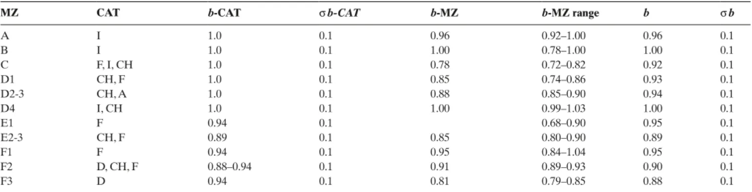
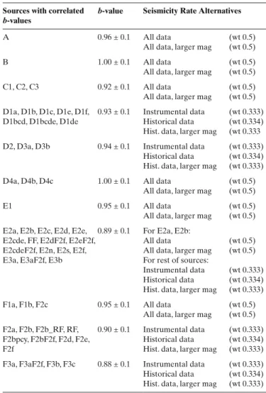
Since the area of interest is not characterised by a still ac-tive subduction zone, and as the precision of focal depths does not allow for an appropriate 3-D-resolution, all the area source boundaries are taken as vertical and “hard”, i.e. the position of zone boundaries is fixed. Given the results of a detailed seis-motectonic analysis leading to alternative zonations in critical areas we feel no need for introducing “soft” boundaries. How-ever, in a few cases and on the basis of specific seismological considerations, some epicentres will be attributed to a seismo-genic zone that is adjacent to the one within which they are lo-cated in our map. Furthermore, when evaluating b-values, some seismogenic zones will have to be lumped together in order to gather sufficient information from the seismogenic zone earth-quake catalogue. Such larger areas defined later and referred to as Macro-Zones (MZs), will be defined for a completeness analysis of the earthquake catalogue.
Generally, seismicity is taken to be homogeneous within all seismogenic zones. This procedure is justified since we de-fine very small seismogenic zones whose size decreases when approaching the sites of the NPPs. No background zones are introduced because the entire map is subdivided into seismo-genic zones.
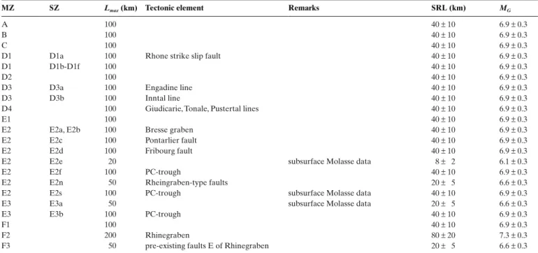
Ruptures that are longer than the dimensions of a given seismogenic zone are allowed to extend beyond its boundaries. We do so because the geometry of the SZs is based on general seismotectonic considerations, and a precise calibration of their size is not done according to the maximum magnitude (Wells and Coppersmith 1994 relations). In any case, ruptures across zone boundaries can occur in the case of very large magnitude events only. Allowing earthquake ruptures to spread across boundaries allows for a very detailed zonation by the use of small seismogenic zones without making large ruptures a priori impossible.
3.1. Mapping Seismotectonic Regions: a first step towards defining seismogenic zones
The map of areas we refer to as Seismotectonic Regions (SRs) presented in Fig. 6 is constructed according to the following pro-cedure: the boundaries drawn in the map of the NKPs (Fig. 5) are maintained, but a new set of boundaries now further subdi-vides them. The criteria for inserting these new boundaries are: (a) seismotectonic evidence (e.g. Sue et al. 1999; Deichmann et al. 2000; Deichmann 2002; Kastrup et al. 2004), and (b) evidence for the existence of sets of pre-existing faults that are prone to reactivation and characterization of their pre-dominant orien-tations. Below we characterize the regions mapped in Fig. 6.
NKPs A and B remained un-subdivided and constitute SRs A and B. Their large distance to the area of interest does not
warrant further subdivision. Most of NKP A is constituted by the Alps-Apennines transfer zones (Meletti et al. 2000) with expected sinistral strike-slip focal mechanisms in the shallow
crust and dip-slip mechanisms in the deep crust. NKP B com-prises the Po plain and is considered as a relatively stable aseis-mic sector.
NKP C is further subdivided according to the work of Sue et al. (1999) and Eva et al. (1997) into: (1) western SR C1,
pres-ently subject to a compressional regime, (2) central SR C2,
now in an extensional regime and (3) eastern SR C3, with a
compressional regime. SRs C1 and C3 are characterised by strike-slip to thrusting fault plane solutions and absorb relative WNW-directed movements between NKPs A and B in respect to NKP E. SR C2, characterised by normal dip-slip fault plane solutions, is currently in extension due to gravitational forces (“over-thickened” crust). These gravitationally induced stresses dominate within SR C2, at least within the shallow crust.
NKP D is further subdivided into: (1) northern SR D1, with
a compressional regime (strike-slip and subordinate thrusting), (2) central dome SR D2, (3) Austroalpine extensional SR D3
and (4) southern compressional SR D4 (no seismotectonic
evi-dence). SR D1 is characterised by the present-day coexistence of all three types of focal mechanisms, including mostly shallow thrusting events. On the whole strike-slip motion and subordi-nate thrusting predomisubordi-nate. The southern limit of SR D1 is dif-fuse. The northern limit (D-E NKP boundary) is well defined
Fig. 6. Map of the Seismotectonic Regions (SRs) arrived at by further subdivi-sion of the NKPs (consult also legend for Fig. 5). The SRs are A: Apennines; B: Adria Plate; C1: western compressional belt of Western Alps; C2: central extensional belt of Western Alps; C3: eastern compressional belt of Western Alps; D1: Northern Alpine compressional region; D2: Central Alpine dome; D3: Eastern Alpine extensional region; D4: Southern compressional region; E1: Massif Central; E2: Bresse – Jura – Western Molasse basin region; E3: Eastern Molasse basin; F1: Paris Basin; F2: Upper Rhine Graben; F3: Black Forest – Schwäbische Alb region.
F2
B
A
F3
E3
E3
E2
E1
D1
D1
D2
D3
D4
C1
C1
C2 C3
C3
F1
0 km 100 KKM KKG KKL KKBand coincides with a change regarding the depth distribution of earthquake foci (Deichmann 2002). The area south of this D-E NKP boundary is characterised by the absence of earthquakes deeper than about 15 km. North of this boundary earthquakes do occur all the way down to the Moho, 35% of them below 15 km and above the Moho. SR D2 is a quiet region, possibly due to the persistence of a thermal anomaly associated with the Tertiary (Lepontine) metamorphic dome. Hence the stress regime remains unknown. The outlines of SR D2 are drawn parallel to the isograds of Lepontine metamorphism. SR D3 (Austroalpine extensional region) is again a region where the far field stress field interferes with gravity forces (similar to SR C2) but extension is oblique (rather than orthogonal as in SR C2) to the strike of the Alpine orogen (Kastrup et al. 2004). The fault plane solutions point to the predominance of normal faulting with subordinate strike-slip motion. SR D4 (southern “compressional” region) represents the eastern continuation of the Friuli compressional realm onto our map. Note, however, that the very intense present-day deformation associated with the Friuli area stops near the SE border of our map. This SR D4 is interpreted as being characterised by a compressional stress regime based on geological arguments only.
NKPs E and F are further subdivided according to the pre-dominance of certain sets of pre-existing faults into: 1) SR E1
Massif Central (reactivation mode unknown), 2) SR E2
Bresse-Jura-Western Molasse basin (reactivated in strike-slip), 3) SR E3 Eastern Molasse basin (reactivated in strike-slip to normal
fault motion), 4) SR F1 Paris basin (reactivated in strike-slip
to normal fault mode), 5) SR F2 Rhine Graben region
(reac-tivated in strike-slip mode), and 6) SR F3 Black Forest and
Schwäbische Alb (reactivated in strike-slip to normal fault mode). SRs E1 and F1 were pre-fractured during the formation of the PC trough system in the Late Paleozoic. In these SRs this fault system predominantly strikes SW-NE (Grellet et al. 1993); its orientation slightly departs from the WSW–ENE strike that predominates in northern Switzerland. No seismotectonic data, except for one normal fault plane solution (Grellet et al. 1993), are available for SR E1 (Massif Central). The pre-existing faults in SR F1 (Paris basin) are presently reactivated in strike-slip to normal fault mode (Grellet et al. 1993). SRs E2 and F2 repre-sent areas that are heavily affected by pre-existent faults that formed during Cenozoic Rhine and Bresse Graben formation; hence these SRs are pre-fractured by the Rhinish system as is evident from surface geology and from subsurface information (i.e. Meyer 1994b). This Rhinish system seems to form a very diffuse transform area occupying the entire western Molasse basin. The Fribourg Fault (FF) line source (Kastrup et al. 2007) lies within SR E2 and exhibits an almost perfect alignment of recent epicentres parallel to the Rhinish system. Both SRs E2 and F3 are characterised by strike-slip fault motions (Plene-fisch & Bonjer 1997; Kastrup et al. 2004). SRs E3 and F3, on the other hand, are dominated by the predominance of faults belonging to the Hercynic system, while those related to the Rhinish system are either absent or rare in these areas (e.g. according to subsurface data; Meyer 1994a; Birkhäuser et al. 2000; Marchant et al. 2005). Seismotectonic evidence points to a predominance of strike-slip to normal faulting motions in SRs E3 and F3 (Plenefisch & Bonjer 1997; Kastrup et al. 2004). 3.2. Logic tree approach used for seismogenic zonation (Fig. 7) Consideration of the distribution of seismicity based on the historical and instrumental catalogues leads to an additional set of boundaries. These will define the Seismogenic Zones (SZs), a set of area sources characterized by uniform seismic properties within their limits. The boundaries of these SZs will largely, but not everywhere, follow the boundaries of the SRs (Fig. 6).
However, given all the uncertainties discussed earlier, al-ternative zonations have to be devised in parts of the area con-sidered. The most important epistemic uncertainty relates to the role of the PC troughs, i.e. the question as to whether or not the PC troughs are presently reactivated by compression or transpression. This question is related to the thick-skinned vs. thin-skinned dilemma and the question as to which fault produced the strong Basel 1356 earthquake, as was discussed earlier.
Fig. 7. Logic tree illustrating the definition of different groups of area sources (Seismogenic Zones; SZs) and line sources, including the weights attributed to the different branches.
Reactivation
PC troughs ReinachFault geometryBasel FribourgFault zonationAlpine
0.2 1.0 1.0 1.0 F2e F2b+RF F2d F2f 1.0 0.7 0.3 0.5 0.5 0.5 0.5 0.5 0.5 No No 0.3 Yes 0.7 No 0.9 No 0.1 Yes E2cde+FF E2c+E2d+E2e E2cde+FF E2c+E2d+E2e E2cde+FF E2c+E2d+E2e 0.2 0.4 0.4 0.4 0.4 0.2 0.4 0.4 0.2 0.4 0.4 0.2 0.4 0.4 0.2 0.4 0.4 0.2 0.4 0.4 D1bcde D1bcde D1bcd+D1e D1b+D1c+D1de D1bcd+D1e D1b+D1c+D1de D1bcde D1bcd+D1e D1b+D1c+D1de D1bcde D1bcd+D1e D1b+D1c+D1de D1bcde D1bcd+D1e D1b+D1c+D1de D1bcde D1bcd+D1e D1b+D1c+D1de D1bcde D1bcd+D1e D1b+D1c+D1de
Before discussing the individual SZs in more detail we will first evaluate the epistemic uncertainties expressed in the form of the logic tree depicted in Fig. 7. Note that one of the major difficulties during PSHA we encountered is that of assigning probabilities used as weights in the computations to bifurca-tions.
Node 1 (PC-Existence). This node considers the potential
reactivation of the PC troughs. While most of the seismotec-tonic evidence argues against a reactivation of these struc-tures, there is substantial geological evidence regarding their reactivation in thrusting mode during the geological past. The potential for thrust-mode reactivation in the future is given a probability of only 0.3, because we decided to put more weight on the seismotectonic evidence, which might reflect the present and future tectonic activity better than the geo-logical record. This first bifurcation leads to the two alterna-tive source maps depicted in Figs. 8 and 9. Fig. 10 shows the seismogenic zonation of the Alpine foreland for the case that the PC troughs are considered as prone to seismogenic re-activation. Assuming that the PC troughs are not seismically active leads to a number of alternative zonations we propose for the Basel area (Fig. 11) and the Alpine foreland (Fig. 12), respectively.
Node 2 (RF). This bifurcation, that addresses epistemic
uncer-tainties regarding the Reinach Fault line source as a potential
source of Basel-type earthquakes (“RF yes” vs. “RF no” in Fig. 7), is only needed when assuming that the PC troughs are not prone to inversion in thrust mode (Fig. 9). This is because the RF, whose orientation is parallel to Rhinish system, cannot be considered a viable alternative for the case that the 1356 Basel earthquake is assumed to be associated with thrust-mode reactivation of the PC troughs. The low weight (0.1) given to the option “RF yes” reflects our scepticism regarding the evidence provided by Meghraoui et al. (2001) that the RF is indeed the seismogenic source of the 1356 Basel earthquake. Note that by choosing the combination “RF no” and scenario “Reactiva-tion of PC troughs No “ (Fig. 7) we in fact assign a probability of 0.7 to the likelihood that SZ F2d (Fig. 9) hosted the Basel earthquake. This is because we regard it more likely that the seismogenic fault linked to the Basel earthquake was parallel to the Rhinish system, oriented parallel to the long side of the rectangle defining SZ F2d (Fig. 9). However, we do not want to exclude the possibility that the Basel earthquake might have been triggered by an intersection effect between the Rhinish and PC trough fault systems, meeting and crossing each other in the Basel area (weight of 0.3 given to square-shaped area F2f, also see Fig. 9), nor do we exclude thrust mode reactivation of the PC troughs (Node 1, branch reactivation PC troughs yes in Fig. 7).
Node 3 (Basel geometry). Because the fault associated with
the 1356 Basel historical earthquake remains unknown we
in-Fig. 8. Map of area sources, i.e. Seismogenic Zones (SZs: boundaries given by solid lines), assuming that the Permo-Carboniferous troughs are prone to seismogenic reactivation (Scenario “Reactivation PC troughs Yes” in Fig. 7). See text for abbreviations and further explanations.
F1a F1b F2c F3b F3c F3c F3a F3a F2e F2e F2b F2b F2a F2a F2a E1 E2a E2c D1b D1b C1 C1 C2 C3C3 A B D4bD4b D4c D3b D3a D3a D4a D4a D2 D1a D1aD1fD1f D1d D1d D1e D1e D1c D1c
E2n E2sE2s
E3b E3b E2b 0 km 100 E2f E2f Reactivation PC troughs yes
Fig. 9. Map of area sources, i.e. Seismogenic Zones (SZs: boundaries given by solid lines) and a few line sources (broken lines), assuming that the Permo-Carboniferous troughs are not prone to seismogenic reactivation (Scenario “Reactivation PC troughs No” in Fig. 7). See text for abbreviations and fur-ther explanations. FFFF F1a F1b F2c F3b F3c F3c F3a F3a F2f F2f F2d F2d F2b F2a F2a E1 E2a E2c D1b D1b C1 C2 C3 A B D4b D4c D3b D3a D3a D4a D4a D2 D1aD1fD1f D1d D1d D1e D1e D1c
E2d E2eE2e E3a E2b
0 km 100
RFRF
Reactivation PC troughs no
troduce a series of alternative zonations for the Basel area. In case of the scenario “Reactivation of PC troughs Yes” no fur-ther bifurcation is needed and SZ F2e is chosen for the Basel area (Fig. 8). Thereby it is implicitly assumed that the 1356 Basel earthquake reactivated the PC troughs somewhere within area F2e. Furthermore, the RF is not considered to be a localizer of seismicity, and the Basel source is represented by the east-west trending SZ F2e (Fig. 8). For the scenario “Reactivation of PC troughs No” (Fig. 9) two alternatives are proposed. If RF is considered a line source, it comes to lie within a larger zone (source area F2b_RF, Fig. 11a). If not, the Basel region is mod-elled as a narrow, north-south trending zone (F2d; Fig. 11b), or as a large zone representing the intersection of north-south and east-west structures (F2f; Fig. 11c). When using SZ F2f the sur-rounding zones are modified (e.g. zone F3a changes to zone F3a_F2f; Fig. 11c).
Node 4 (Fribourg Fault FF). While activity along the Fribourg
Fault (FF) is well documented by post-1975 instrumental data (Kastrup et al. 2007) there remains an epistemic uncertainty as to whether an introduction of this line source is needed or not. Hence a bifurcation was applied to all branches that assume scenario “Reactivation of PC troughs No”. The node 4 bifurca-tions were assigned equal (0.5) probabilities because we could not decide as to which branch might be more likely. Either FF
is not treated as a line source and areas E2c, E2d and E2e are treated as separate SZs (see Figs. 12a & b), or alternatively, FF represents an important line source within a larger source area consisting of E2c, E2d and E2e, lumped together to area E2cde (see Figs. 12c & d).
Node 5 (Alpine zonation). The alternatives regarding SZs
D1b, D1c, D1d and D1e depicted in Fig. 13 are treated with 3 branches in the logic tree (Fig. 7) as follows: Branch 1: D1b, D1c, D1d, and D1e are grouped into 1 SZ (D1bcde; Fig. 13a); this branch is weighted 0.2. Branch 2: D1b, D1c, and D1d are grouped into 1 SZ (D1bcd), which is separated from D1e (Fig. 13b); this branch is weighted 0.4. Branch 3: D1d and D1e are grouped into one SZ (D1de), which is separated from D1b and D1c (Fig. 13c); this branch is weighted 0.4. These alterna-tives are independent of all previously mentioned alternaalterna-tives and they were applied to every previously defined branch of the logic tree.
3.3. Definition and characterization of Seismogenic Zones We now discuss details concerning the mapping of the SZs shown in Figs. 8 to 13. Note that the exact location of these limits is crucial in the neighbourhood of the NPPs, since area sources are characterized by uniform seismic properties all the way to their limits. The boundaries of the SZs will largely, but not everywhere, follow the boundaries of the SRs (Fig. 6). 3.3.1. Seismogenic Zones within the Neotectonic-Kinematic Provinces A, B, and C
The NKPs A and B (Fig. 5) remain undivided since they are too distant from the NPP sites to warrant further subdivision. They correspond to SZ A (Apennines) and SZ B (Adria plate),
respectively. No assumptions are proposed concerning orienta-tion of faults and type of faulting within SZ A. SZ B is almost aseismic.
Also seismotectonic region SR C1 (Fig. 6) remains undivided and represents SZ C1 (western compressional belt of Western
Alps). No a-priori orientation of active faults is assumed; ex-pected sense of slip is strike-slip to thrusting. SR C2, not subdi-vided either, is identical with SZ C2 (central extensional belt of
Western Alps). There the orientation of active faults is assumed to be orogen-parallel, i.e. N-S to NE-SW, expected sense of slip is normal faulting. SR C3, also not subdivided, represents SZ C3 (eastern compressional belt of Western Alps). No a-priori
orientation of active faults is assumed; expected sense of slip is strike-slip to thrusting.
3.3.2. Seismogenic Zones within the Neotectonic-Kinematic Province D
The D1-D3 boundary as shown in Fig. 6, i.e. the map of the SRs, had to be slightly modified according to seismicity crite-ria. The boundaries between NKPs D and E, as well as those
Fig. 10. SZs in the Alpine foreland assuming that the Permo-Carboniferous troughs are prone to seismogenic reactivation (Scenario “Reactivation PC troughs Yes” in Fig. 7).
5° 50° 49° 48° 47° 46° 45° 6° 7° 8° 9° 10° 11°
E2s
E2f
E2c
E2n
F2e
F2bpcy
F3a
E3b
between NKPs C and B also had to be slightly modified. Changes to these major boundaries are made taking into ac-count the following considerations: 1) near Lake Geneva the northern boundary of NKP D with E is moved away from the front of the Alps by a small distance into the Molasse basin in order to capture badly located epicentres around Geneva within NKP D (instead of E); 2) the discrete southern
bound-ary of NKP D with C and B (Valais-Simplon-Garda move-ment zone) is replaced by a series of elongated SZs (D1a, D4a, and D4b). Particularly SZ D4a overrules former bound-aries drawn in Fig. 6. The SZs within the SR D1, as depicted in Figs. 8 & 9 (see also Fig. 13 for alternative SZs in the Alpine foreland previously discussed in the context of node 5 of the logic tree of Fig. 7), are characterized as follows:
Fig. 11. Alternative SZs for Basel area assuming that the Permo-Carboniferous troughs are not prone to seismogenic reactivation (Scenario “Reactivation PC troughs No” in Fig. 7), see text for further explanations.
5° 50° 49° 48° 47° 46° 6° 7° 8° 9° 10° 11° 5° 50° 49° 48° 47° 46° 6° 7° 8° 9° 10° 11° 5° 50° 49° 48° 47° 46° 6° 7° 8° 9° 10° 11° F2b_RF F3a F3a F2d F2b F2b_F2f RF F2f F3a_F2f
a
b
c
Fig. 12. Alternative SZs in the Alpine foreland assuming that the Permo-Carboniferous troughs are not prone to seismogenic reactivation (sce-nario “Reactivation PC troughs No” in Fig. 7); see text for further explanations.
5° 49° 48° 47° 46° 45° 6° 7° 8° 9° 10° 11° E2e E2c E2c E2c E2d E3a 5° 49° 48° 47° 46° 45° 6° 7° 8° 9° 10° 11° FF E2cde E3a FF E2cdeF2f 5° 49° 48° 47° 46° 45° 6° 7° 8° 9° 10° 11° E2eF2f E2c E2dF2f E3aF2f 5° 49° 48° 47° 46° 45° 6° 7° 8° 9° 10° 11° E3aF2f
a
b
c
d
SZ D1a (westernmost part of the Valais-Simplon-Garda
movement zone) is an E-W trending belt of enhanced seismic-ity, including the northern part of the Valais active area, located within the southernmost Helvetic nappes. Fault-orientation is roughly E-W and parallel to the elongated shape of the area. Sense of slip is predominantly dextral strike-slip.
SZ D1b (Savoy part of northern margin of the Alps) is
lo-cated in an area were Alps and Jura meet. This SZ is transi-tional to SZ C1 (external part of Western Alps) and is relatively quiescent compared to the more active SZ D1c. No a-priori fault orientation is assumed and sense of slip is strike-slip with subordinate thrusting.
SZ D1c (western Switzerland part of northern margin of
the Alps) is characterized by a relatively high density of epicen-tres. The boundary of this SZ appears transitional with SZ D1a (northern part of Valais active zone). No a-priori fault orienta-tion is assumed and dominant sense of slip is strike-slip with subordinate thrusting or normal faulting.
SZ D1d (central Switzerland part of northern margin of the
Alps) includes the seismically very active area around Lake Lucerne, mostly inferred from historical information. Histori-cal record probably includes thrusting quakes. No a-priori fault orientation is assumed and dominant sense of slip is strike-slip, with subordinate thrusting.
SZ D1e (eastern Switzerland part of northern margin of
the Alps) represents a part of the northern margin of the Alps, which might be kinematically linked via SZs E3a and E3b (eastern Molasse basin) to the northward propagation of fore-land deformation across the Molasse basin, causing increasing amounts of recent uplift in the area west of Lake Constance (Müller et al. 2002). No a-priori fault orientation is assumed; dominant sense of slip is strike-slip (with subordinate thrust-ing).
SZ D1f (Aar massif) is a quiescent zone. No assumptions
are made regarding fault orientation and/or sense of slip. SR D2 remains undivided and corresponds to SZ D2
(Cen-tral dome), a quiescent zone, which is adjacent to D1f and
cor-responds to the Lepontine metamorphic dome. No assumptions regarding fault orientation and/or sense of slip are made.
SR D3 is subdivided into two SZs. SZ D3a (Mittelbünden –
Engadin – northern Valtellina area) exhibits enhanced seismic-ity, with predominantly normal faulting and subordinate strike-slip. No assumptions are made regarding fault orientation. SZ D3b (western Austria) is generally characterized by moderate
seismicity, but includes quite active areas such as the Inntal line. Hence, seismicity appears unequally distributed, but given its relatively large distance from the NPPs this SZ is nevertheless considered homogeneous. Fault orientation is ENE-WSW and sense of slip is sinistral strike-slip.
Three SZs are defined within the SR D4.
SZ D4a (Insubric part of Valais-Simplon-Garda movement
zone) is a relatively quiet part of a longer and important move-ment zone. No assumptions can be made regarding fault orien-tation and sense of slip.
SZ D4b (Southern Alps part of Valais-Simplon-Garda
movement zone) is relatively active and directly connects with the Friuli area, located immediately east of the margin of the map. There is good agreement between the outlines of our map with those provided by with the data of Meletti et al. (2000). Reverse faults strike N70°E.
SZ D4c (Trento area) is a relatively quiescent block. No
assumptions can be made regarding fault orientation and sense of slip.
3.2.3. Seismogenic Zones within the Neotectonic-Kinematic Province E
The two alternative zonations proposed in Figs. 8 & 9 largely deal with alternative subdivisions of this province. The E2-E3 boundary (Fig. 6) between the eastern and western parts of the Molasse basin is modified and only kept in one of the two op-tions for seismogenic zonation, namely that depicted in Fig. 9. Moreover, the boundary between the SRs E2 and F2 (Fig. 6) has to be modified in the Basel area in order to properly take
Fig. 13. Alternative SZs for the Northern Alpine compressional region, see text for further explanations.
5° 49° 48° 47° 46° 45° 6° 7° 8° 9° 10° 11° D1bcde 5° 49° 48° 47° 46° 45° 6° 7° 8° 9° 10° 11° D1bcd D1e 5° 49° 48° 47° 46° 45° 6° 7° 8° 9° 10° 11° D1c D1b D1de
a
b
c
account of the specific needs of the Basel source area (see Figs. 8 & 9).
No further subdivision is necessary within SR E1 in view of the large distance to the power plants. In SZ E1 (Massif
Cen-tral) no assumptions are made regarding fault orientation and sense of slip.
SR E2, however, is subdivided into various SZs as follows.
SZ E2a (Basse Dauphinée) is characterized by a relatively
higher seismic activity, when compared to E2b. Fault-orienta-tion is that of the Rhinish system, sense of slip is strike-slip.
SZ E2b (Bresse) is a relatively quiescent area.
Fault-ori-entation is that of the Rhinish system, sense of slip is sinistral strike-slip.
SZ E2c (Western Jura) is a relatively quiescent area, when
compared to E2d. Fault-orientation is that of the Rhinish sys-tem, predominant sense of slip is sinistral strike-slip.
The following series of SZs are only activated when the sce-nario “reactivation PC troughs Yes” of Fig. 7 is assumed:
SZ E2d (Western Molasse basin), only defined in Fig. 9, is
heavily pre-fractured by Rhinish faults, of which line source FF (located within this area) is a particularly active example. Pre-fracturing also occurred by the PC trough system, particularly near the Molasse-Jura border. Fault orientation is NNE–SSW and sense of slip is sinistral strike-slip. Line source FF, located
within E2d, also is only defined for the scenario “reactivation PC troughs No” of Fig. 7 (see Fig. 9), and furthermore it only represents an alternative in one of the FF nodes (Fig. 7). Doc-umented offsets of the base of the Mesozoic strata coincide with line source FF (see Meyer 1994b; Kastrup et al. 2007). They represent a good example for thick-skinned reactivation of former faults by sinistral strike-slip parallel the Rhinish sys-tem with a transpressive component (see Kastrup et al. 2007 for geological and seismotectonic evidence). Inversion of the PC trough system below the Molasse basin by thrusting (geo-logical evidence is available from seismic sections only) is en-visaged when assuming the scenario “reactivation PC troughs Yes” in Fig. 7 to be valid (see Fig. 8); in this case line source FF is de-activated.
SZ E2e (Central Molasse basin), a relatively quiescent area
(Fig. 9), also is only defined within the scenario “Reactivation PC troughs No” of Fig. 7. This SZ is located east of the E2– E3 boundary as defined in Fig. 6, coinciding with the eastern limit of existence of the Rhinish system. Some epicentres ne-cessitate a very slight correction of this boundary. No assump-tions can be made regarding fault orientation and sense of slip within this SZ.
Also SZ E3a (eastern Molasse, see Fig. 9) is only defined
within scenario “reactivation PC troughs No” of Fig. 7 and, hence, when present-day tectonic activity is assumed to be primarily thin-skinned. This area is characterised by recent up-lift and represents a neotectonically active zone according to Müller et al. (2002). In comparison to E2e this is a zone of in-creased seismicity. The SZ is pre-fractured by the Hercynic and PC trough systems, particularly at its northern margin. Within the basement, sense of slip is expected to be a combination of
dextral strike-slip and normal faulting, primarily reactivating the Hercynic system.
The following series of SZs are only activated when the sce-nario “reactivation PC troughs Yes” of Fig. 7 is assumed, hence when assuming that the PC trough is presently reactivated. This scenario proposes inversion of normal faults by thrusting or transpression. It also infers that the Basel earthquake corre-sponds to such an inversion of a PC trough in the Basel area (see description of SZ F2e). These SZs span the SRs E2 and E3 of Fig. 6 (western and eastern Molasse basin) and are the following (see Fig. 8):
SZ E2n (eastern Jura) is located between the northern PC
trough (SZs F2e and E3b) and the southern PC trough (SZ E2f). It is pre-fractured by the Rhinish system; the expected sense of slip is sinistral strike-slip.
SZ E2f (southern PC trough) corresponds to the southern
PC trough, joining the northern one in the NE (boundary with SZ E3b) according to the available subsurface data. This SZ is pre-fractured by ENE-WSW-striking normal faults, which are supposed to be presently reactivated by thrusting. The area is also pre-fractured by the Rhinish system and reactivated in sinistral strike-slip mode.
SZ E2s (southern Molasse basin) encompasses the rest of
the Molasse Basin located south of SZ E2f. The area is pre-frac-tured by the Rhinish, Hercynic, and PC trough systems. Sense of slip is expected to be sinistral strike-slip (Rhinish system), a combination of dextral strike-slip and normal faulting (Herc-ynic system) and minor thrusting (PC trough system).
SZ E3b (eastern part of northern PC through) is an
elon-gated strip. It contains the eastern part of the northern PC trough, linking to Basel SZ F2e (western part of northern PC). Inversion of the PC trough system by thrusting is expected, possibly in the form of characteristic earthquakes implying that each fault generates earthquakes of a well-defined mag-nitude only (Schwartz & Coppersmith 1984). However, the expected recurrence rate is lower than that expected for SZ F2e (Basel area). In addition, the Hercynic system is also ex-pected to be reactivated by a combination of sinistral strike-slip motion and extension (e.g. “Neuhausener Störung”, an extremely well studied area; Birkhäuser et al. 2000; Marchant et al. 2005).
3.2.4. Seismogenic Zones within Neotectonic-Kinematic Province F
The Basel area, and particularly the Basel 1356 earthquake, plays a key role within NKP F. In order to properly account for the seismicity in the Basel area the boundary between NPK F and NKP E (Fig. 5) is modified, as well as that between the SRs F2 and F3 (Fig. 6). Several alternatives are considered for the Basel area.
Two SZs are defined within SR F1 (Fig. 8). SZ F1a (Paris
basin) includes most of SR F1 and is characterised by very moderate seismicity. The orientation of faults is variable; strike-slip to normal fault modes predominate. SZ F1b (Lower Rhine