HAL Id: hal-00296949
https://hal.archives-ouvertes.fr/hal-00296949
Submitted on 19 Sep 2006
HAL is a multi-disciplinary open access
archive for the deposit and dissemination of
sci-entific research documents, whether they are
pub-lished or not. The documents may come from
teaching and research institutions in France or
abroad, or from public or private research centers.
L’archive ouverte pluridisciplinaire HAL, est
destinée au dépôt et à la diffusion de documents
scientifiques de niveau recherche, publiés ou non,
émanant des établissements d’enseignement et de
recherche français ou étrangers, des laboratoires
publics ou privés.
Storm surge in the Adriatic Sea: observational and
numerical diagnosis of an extreme event
L. Zampato, G. Umgiesser, S. Zecchetto
To cite this version:
L. Zampato, G. Umgiesser, S. Zecchetto. Storm surge in the Adriatic Sea: observational and numerical
diagnosis of an extreme event. Advances in Geosciences, European Geosciences Union, 2006, 7,
pp.371-378. �hal-00296949�
Advances in Geosciences, 7, 371–378, 2006 SRef-ID: 1680-7359/adgeo/2006-7-371 European Geosciences Union
© 2006 Author(s). This work is licensed under a Creative Commons License.
Advances in
Geosciences
Storm surge in the Adriatic Sea: observational and numerical
diagnosis of an extreme event
L. Zampato1, G. Umgiesser2, and S. Zecchetto3
1Istituzione Centro Previsioni e Segnalazioni Maree – Comune di Venezia, Venice, Italy 2Istituto di Scienze Marine ISMAR-CNR, Venice, Italy
3Istituto di Scienze dell’Atmosfera e del Clima ISAC-CNR, Padua, Italy
Received: 28 October 2005 – Revised: 15 June 2006 – Accepted: 30 June 2006 – Published: 19 September 2006
Abstract. Storm surge events occur in the Adriatic Sea,
in particular during autumn and winter, often producing flooding in Venice. Sea levels are forecasted by numeri-cal models, which require wind and pressure fields as in-put. Their performances depend crucially on the quality of those fields. The storm surge event on 16 November 2002 is analysed and simulated through a finite element hydrody-namic model of the Mediterranean Sea. Several runs were carried out, imposing different atmospheric forcings: wind fields from ECMWF analysis, high resolution winds from the limited area model LAMI and satellite observed winds from QuikSCAT (NASA). The performance of the hydrodynamic model in each case has been quantified. ECMWF fields are effective in reproducing the sea level in the northern Adriatic Sea, if the wind speed is enhanced by a suitable multiply-ing factor. High resolution winds from LAMI give promis-ing results, permittpromis-ing an accurate simulation of the sea level maxima. QuikSCAT satellite wind fields produce also en-couraging results which claim, however, for further research.
1 Introduction
The Adriatic Sea is a semi-enclosed sea, extending about 1000 km by 200 km and entirely surrounded by mountain chains. Particularly during autumn and winter, storm surge events occur in its northern part: the sea level rises to un-usual values, because of the local low pressure system and of strong south-east sirocco wind channelled by orography. If such events occur in phase with the astronomical tide, they produce the flooding of the coastal regions and the phe-nomenon of high water in Venice.
Sea levels are forecasted by numerical models, which re-quire wind and pressure fields as input. This study, which
Correspondence to: L. Zampato
(lucia.zampato@comune.venezia.it)
uses the SHYFEM 1 model developed at ISMAR-CNR of Venice, consists of a set of hindcast numerical simulations for November 2002, a month characterised by a severe storm surge event on day 16.
A crucial problem in the numerical modelling of the storm surge is the quality of the meteorological fields used as forc-ing: inaccuracies in these forcing terms propagate in the computation of the sea state. The aim of this paper is to eval-uate the performance of the SHYFEM hydrodynamic model, when driven by different meteorological forcings. Three kinds of atmospheric input were considered: wind and at-mospheric pressure analysis fields of the ECMWF global model, initialised every day through the run of the previ-ous day and including a data assimilation scheme; wind and atmospheric pressure fields from the high resolution LAMI model, operational at the meteorological service ARPA of Emilia Romagna (Italy); winds observed by the satellite QuikSCAT (NASA) and atmospheric pressure analysis fields of the ECMWF global model.
In Sect. 2 the storm surge event on 16 November 2002 is described, according to the available observations. Section 3 is devoted to present the SHYFEM model, and to describe and discuss the different atmospheric inputs used in the sim-ulations. Section 4 reports some conclusive remarks.
2 The storm surge event on 16 November 2002
The high water event occurred in Venice on 16 November 2002 was the fourth highest event even registered in the city: in the historical centre (Punta Salute) the water level reached +147 cm on the local datum, flooding more than 90% of the city ground.
1Abbreviations: SHYFEM; Shallow water HYdrodynamic
Fi-nite Element Model, ISMAR; Istituto di Scienze MARine, CNR; National Council of Research, ICPSM; Istituzione Centro Pre-visioni e Segnalazioni Maree, ECMWF; European Centre for Medium-Range Weather Forecasts, LAMI; Limited Area Model Italy, ARPA; Agenzia Regionale Prevenzione e Ambiente.
372 L. Zampato et al.: Storm surge in the Adriatic Sea
Fig. 1. Observed sea level at CNR platform, 11–20 November 2002: total level (solid line), astronomical tide (dashed line), surge (limit of
the filled area).
38 N 39 N 40 N 41 N 42 N 43 N 44 N 45 N 46 N 12 E 13 E 14 E 15 E 16 E 17 E 18 E 19 E 20 E 21 E 10 m/s < 3 m/s 3-8 m/s 8-11 m/s 11-14 m/s 14-17 m/s 17-20 m/s > 20 m/s QuikSCAT 16-Nov-2002 04:00:50
Fig. 2. Wind field over the Adriatic Sea observed by the QuikSCAT
satellite on 16 November 2002 at 04:00 UTC.
Figure 1 shows the sea level measured in the Adriatic Sea, at the CNR platform (45◦180N, 12◦300E), about 15 km off-shore the Venice Lagoon, during the period 11–20 Novem-ber. The total observed level (solid line) is decomposed in the astronomical tide (dashed line) and in the meteorological residual, or surge (limit of the filled area). The surge
be-came relevant, over +40 cm, from the evening of 14 ber and reached the maximum value of 86 cm on 16 Novem-ber around 12:00 UTC. The maximum surge occurred at low astronomical tide.
The meteorological condition at the flooding time was characterized by a deep depression over the Gulf of Biscay which induced a pressure difference between the southern and northern Adriatic. The wind field observed at 04:00 UTC of the same day by the NASA’s satellite QuikSCAT (Fig. 2), shows an intense sirocco wind over the whole Adriatic, with speeds reaching 20 m/s along the Croatian coast.
The time series of pressure and wind, observed at the CNR platform and at several Adriatic coastal stations of the SYNOP network, show the persistence of a marked pressure difference between southern and northern Adriatic (17 hPa between Dubrovnik and Venice-Tessera on 16 November at 15:00 UTC) and of a strong sirocco wind over the whole basin (as to 22 m/s at CNR platform and 24 m/s at Termoli) in the period 14–16 November.
The strong correlation among surge and weather parame-ters, in particular the atmospheric pressure and the wind act-ing on the sea surface, is well known (Pugh, 1987). Local atmospheric pressure induces an inverse barometric effect, consisting in a rise of the water level when the atmospheric pressure diminishes. This effect can be roughly quantified in about 1 cm for 1 hPa drop in pressure. The wind effect con-sists in a transfer of momentum from the atmosphere to the sea, through the friction at the air-water interface. This term, called wind stress, principally depends on the wind speed, but also on the structure of the atmospheric boundary layer and the wave field developed during the storm. Also the wind
L. Zampato et al.: Storm surge in the Adriatic Sea 373 direction and the fetch, combined with the local geographic
features of the basin, play an important role in generating the surge. In particular strong south-easterly winds (sirocco) over the Adriatic Sea, associated with the crossing of cy-clones over the Mediterranean Sea, are effective in pushing the water toward the northern closed end of the basin and raising the sea level. The importance of sirocco wind in pro-ducing flooding events in Venice was evidenced by many au-thors (see for example Palmieri and Finizio, 1970; Tomasin and Frassetto, 1979; Canestrelli et al., 2001). The wind dura-tion is also important, but its effect can not be simply quan-tified, because it has important consequences on the Adri-atic seiches. The seiches are free oscillation of the AdriAdri-atic Sea, initially stimulated by meteorological factors and per-sisting, progressively attenuated, for several days, also after the storm has finished. Theoretic considerations and numer-ical experiments have shown that the development of the se-iche, its amplification or attenuation, strongly depend on the duration of the wind, giving origin to the motion (Tomasin et al., 2005).
3 Numerical simulations
3.1 The SHYFEM hydrodynamic model
The Shallow-water HYdrodynamic Finite Element Model (SHYFEM), developed at ISMAR-CNR of Venice (Umgiesser et al., 2004), is operational at ICPSM since November 2002 (Canestrelli and Zampato, 2005). The 2-dimensional version of the model solves the vertically integrated shallow-water equations, in their linearized formulation with levels and transports. The model uses a semi-implicit time stepping scheme that does not restrict the time step with a stability criterion due to the fast moving gravity waves. The finite element approach allows to use variable size grids: the region of interest, in this case the northern Adriatic Sea, is represented with high spatial resolution (about 1.5 km), maintaining a relatively coarse resolution (30÷40 km) in other areas of the Mediterranean.
For the purposes of this study, some simulations of the SHYFEM model were realized on the whole Mediterranean domain, others using a grid of the only Adriatic Sea.
The model is forced by the atmospheric pressure gradients and the wind stress τ , which can be computed from the wind velocity U =(u, v) through: τ =(τx, τy)=ρaCD|U |(u, v), where u and v are the zonal and meridional wind compo-nents, ρa=1.225 kg/m3 is the air density, kept constant in this study, and CD is the dimensionless drag coefficient. In this work CD has been parametrized in four different ways (labels between brackets indicate the name of the corre-sponding run with the SHYFEM model):
– a constant formulation: CD=2.5×10⁻³(run C);
– a commonly used formulation:
CD=(0.630+0.066|U |)10−3(run SB) (Smith and Banke, 1975);
– a wave dependent formulation (run W), whith CD
com-puted by ECMWF, through the coupling between the atmospheric model and a wave model (Janssen, 1989; Persson, 2000);
– an atmospheric boundary layer dependent formulation
(run BL), in which CD is computed from the wind speed, air temperature, sea surface temperature, air humidity, with an iterative procedure, supposing ini-tial neutral stability atmospheric conditions (Liu et al., 1979).
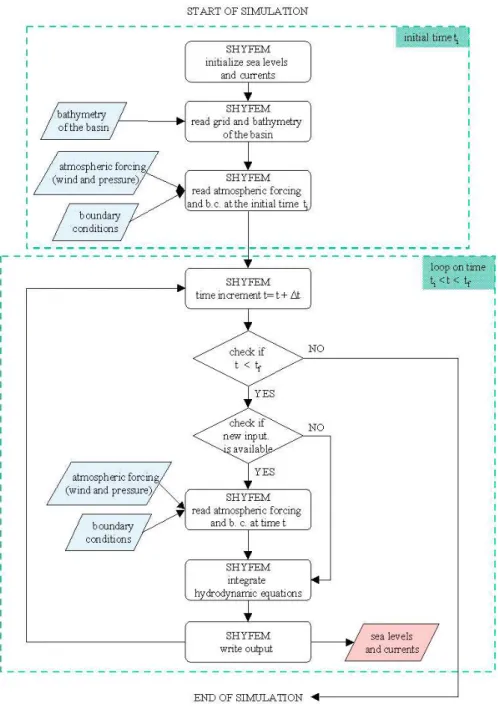
The time step of the hydrodynamic model is 5 min, which is a good compromise between the accuracy of the compu-tations and the computational load. At every time step the model uses the above forcings and computes new values of the water levels and current speeds. The SHYFEM model’s operation is represented in the flow chart in Fig. 3. Since the forcings (atmospheric pressure, wind) are only available ev-ery 6 h, they are linearly interpolated in order to provide the model with a pressure and wind field at every time step. 3.2 The atmospheric input
3.2.1 ECMWF atmospheric fields
The ECMWF atmospheric general circulation model (Pers-son, 2000), based on the primitive equations, includes the effects of orography, a parametrization of boundary layer processes, a radiation scheme, cloud physics, a description of the hydrological cycle. The atmospheric model assimi-lates observations (both in-situ and satellite data) through a four dimensional variational system (4DVAR) and produces analysis and forecast fields. The analysis fields are com-puted by ECMWF at the synoptic hours 00:00, 06:00, 12:00, 18:00 UTC, comparing the available observations with a very short (6-h) forecast of the same model used for the opera-tional forecast.
The third generation Wave Model WAM (WAMDIgroup, 1988) is integrated into the atmospheric model, allowing the computation of the two-way interaction between wind and waves.
The fields used in this work are the analysis fields of pres-sure at the mean sea level and the wind at 10 m, over the Mediterranean Sea, computed by the version T511 (horizon-tal resolution of about 39 km). They have been interpolated on a regular lat-lon grid with 0.5◦ resolution for computa-tional reasons.
3.2.2 LAMI atmospheric fields
The Limited Area Model Italy (LAMI) is the implementa-tion of the Lokal-Modell (LM) developed at the Deutscher Wetterdienst (DWD) in the framework of the european Con-sortium for Small-scale MOdelling (COSMO) (Doms and Schattler, 2002). LM is a non-hydrostatic limited-area atmo-spheric model, based on the primitive thermo-hydrodynamic
374 L. Zampato et al.: Storm surge in the Adriatic Sea
Fig. 3. Flow chart of the SHYFEM model: input data are represented in blue, output data in red.
equations describing compressible flow in a moist atmo-sphere. It uses rotated geographical coordinates and a gener-alized terrain-following vertical coordinate. The LAMI oper-ational version has horizontal spatial resolution of 7 km and cover only the central part of the Mediterranean Sea. The fields used here were supplied by the Meteorological Ser-vice of Emilia Romagna (SMR-ARPA-EMR) that performs two operational runs every day, at 00:00 and 12:00 UTC, producing forecasted fields at time lags +3, +6,..., +72 h. The boundary conditions for the limited area model are sup-plied by the general circulation atmospheric model (GME) of the DWD. To be imposed as forcing for the hydrodynamic
model, LAMI fields were interpolated on a lat-lon grid with spacing of 10 km.
Unfortunately, for the considered period of November 2002, data assimilation procedures were still not imple-mented in the LAMI model: as consequence, fields obtained from the LAMI operational forecast runs has been used to force the SHYFEM model.
3.2.3 QuikSCAT satellite fields
The scatterometer SeaWinds on board of the QuikSCAT satellite (NASA) provides wind fields over the oceans with a maximum spatial resolution of about 25 km×25 km.
L. Zampato et al.: Storm surge in the Adriatic Sea 375 -0.2 0 0.2 0.4 0.6 0.8 1 1.2 0 5 10 15 20 25 30 Residual level (m) Time (days) CNR platform - November 2002 E_C0 R=0.74 E_SB0 R=0.54 E_BL0 R=0.56 E_W0 R=0.62 observed data -0.2 0 0.2 0.4 0.6 0.8 1 1.2 0 5 10 15 20 25 30 Residual level (m) Time (days) CNR platform - November 2002 E_SB1 R=0.80 E_SB2 R=0.77 observed data -0.2 0 0.2 0.4 0.6 0.8 1 1.2 -0.2 0 0.2 0.4 0.6 0.8 1 1.2
Modelled residual level (m)
Observed residual level (m) CNR platform - November 2002 - Run AE_SB3
y=0.86-0.04, R=0.90 -0.2 0 0.2 0.4 0.6 0.8 1 1.2 0 5 10 15 20 25 30 Residual level (m) Time (days) CNR platform - November 2002 run AE_SB1, R=0.90 run AE_SB3, R=0.90 observed data
Fig. 4. Residual sea level at the CNR platform, November 2002. Dots represent observed data, lines show the values computed by the
SHYFEM model, forced by ECMWF fields. Top panels: runs with different formulations of the wind stress. Middle panels: runs with mul-tiplying correction factors. Bottom panels: runs with mulmul-tiplying correction factors and observed sea level imposed as boundary conditions at Otranto.
It covers the Adriatic Sea on average twice a day, in the early morning and in the mid afternoon (approximately at 04:00 UTC and 17:00 UTC). For this reason, the satellite winds have been used along with the ECMWF fields, to ob-tain a data set suitable to drive the hydrodynamic model. ECMWF already assimilates the satellite wind data through its 4DVAR assimilation scheme. However, due to its coarser resolution with respect to the satellite fields, as well as to the intrinsic smoothing of the data carried out by any
as-similation scheme (Che´ruy et al., 2004), the wealth of infor-mation about the spatial variability provided by the satellite fields cannot be find out in the ECMWF analysis fields. This is the main reason why satellite and ECMWF winds have been used together, in spite of their intrinsic different nature. QuikSCAT data over the Adriatic Sea, when available, were simply inserted into ECMWF data over the Mediterranean Sea. At the other times, ECMWF data were used. Details on the adopted procedure are given in Canestrelli et al. (2003).
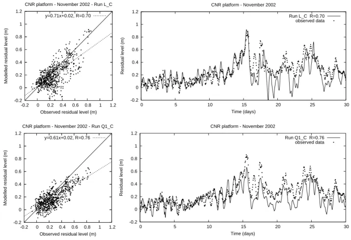
376 L. Zampato et al.: Storm surge in the Adriatic Sea -0.2 0 0.2 0.4 0.6 0.8 1 1.2 -0.2 0 0.2 0.4 0.6 0.8 1 1.2
Modelled residual level (m)
Observed residual level (m) CNR platform - November 2002 - Run L_C
y=0.71x+0.02, R=0.70 -0.2 0 0.2 0.4 0.6 0.8 1 1.2 0 5 10 15 20 25 30 Residual level (m) Time (days) CNR platform - November 2002 Run L_C R=0.70 observed data -0.2 0 0.2 0.4 0.6 0.8 1 1.2 -0.2 0 0.2 0.4 0.6 0.8 1 1.2
Modelled residual level (m)
Observed residual level (m) CNR platform - November 2002 - Run Q1_C
y=0.61x+0.02, R=0.76 -0.2 0 0.2 0.4 0.6 0.8 1 1.2 0 5 10 15 20 25 30 Residual level (m) Time (days) CNR platform - November 2002 Run Q1_C R=0.76 observed data
Fig. 5. Residual sea level at the CNR platform, November 2002. Top panels: runs with LAMI forcing and costant drag coefficient. Bottom
panels: runs with QuikSCAT forcing and costant drag coefficient.
3.3 Results and discussion
A variety of runs have been realized forcing the hydro-dynamic SHYFEM model by different data sources during November 2002.
A first set of runs was carried out with the model running in the Mediterranean Sea domain, driven by ECMWF fields. The different formulations of the wind stress term, listed in Sect. 3.1, were used and correction factors for the ECMWF wind speed were adopted. A second group of runs was re-alised with the SHYFEM model running in the Adriatic Sea domain, forced by LAMI fields. Finally, some runs were carried out forcing the model of the Mediterranean Sea by QuikSCAT wind fields integrated by the ECMWF fields to obtain a complete atmospheric input.
The results are presented in terms of the modelled and ob-served residual sea level time series at the CNR platform lo-cation, and of scatter diagrams. Fig. 4 shows the results of the runs with ECMWF forcing: the basic run E C0, with constant drag coefficient (top panel of Fig. 4), yields sea level values strongly underestimated, but correlated with data (R=0.74). The maximum surge on day 16 November is sim-ulated with an error of −31 cm and the bias, computed on the whole month, is E=−10 cm. The other formulations of
the wind stress term, even the most complex as the wave dependent or the boundary layer dependent, provide worse results (again in the top panel of Fig. 4). To compensate this strong underestimation, the ECMWF wind speed was enhanced, over the Adriatic Sea, in three ways: through a constant factor 1.5 (run E SB1), as suggested by Cavaleri and Bertotti (1997), through a constant factor 1.35, recently pro-posed by Cavaleri (personal communication, 2005), whose results are not shown in this paper, and through a spatially variable factor, given by the ratio between QuikSCAT and ECMWF in each grid point of the Adriatic, averaged on the whole month of November 2002 (run E SB2). The results (middle panel of Fig. 4) show an evident improvement, both in the correlation (R=0.80) and in the simulation of the sea level peak, even if a negative bias remains in the second half of the month.
Supposing that this bias could depend on a not perfect re-production of the sea level in the Ionian Sea, we realized some runs with the two enhancing factors 1.5 (run AE SB1) and 1.35 (run AE SB3), using the model of the Adriatic only and imposing the observed sea levels at Otranto as boundary conditions. The results (bottom panel of Fig. 4) evidence an improvement with respect to the previous runs, both in the correlation (R=0.90) and in the agreement with data
dur-L. Zampato et al.: Storm surge in the Adriatic Sea 377 0.00 0.00 0.04 0.04 0.08 0.08 0.12 0.12 0.16 0.16 0.20 0.20 0.24 0.24 0.1 0.2 0.3 0.4 0.5 0.6 0.7 0.8 0.9 0.95 0.99 1.00 0.0 Correlation Coeff. 2002 Standard Deviation 2002 Standard Deviation 2002 E_C0 E_SB1 E_SB2 L_C Q1_C 0.00 0.00 0.04 0.04 0.08 0.08 0.12 0.12 0.16 0.16 0.20 0.20 0.24 0.24 0.1 0.2 0.3 0.4 0.5 0.6 0.7 0.8 0.9 0.95 0.99 1.00 0.0 Correlation Coeff. 2002 Standard Deviation 2002 Standard Deviation 2002 AE_SB1 AE_SB3 AL_SBAQ1_C
Fig. 6. Residual sea level at the CNR platform location, November 2002. Taylor diagram with results of the runs with different forcings.
Left panel: runs without using observed sea levels. Right panel: runs with observed sea levels at Otranto, imposed as boundary conditions.
ing the second half of November (bias E=−5 cm, in the run AE SB1).
Some of the results obtained with LAMI and QuikSCAT forcing are shown in Fig. 5. Using the LAMI fields, the sim-ulation of the surge peak on 16 November results accurate (top panel), without need of any enhancement of the wind field. Unfortunately, the modelled sea level shows a too high excursion with respect to the observed data. This can be due to the particular procedure used to construct the input for the hindcast simulation: it was obtained joining together LAMI fields, computed by different short forecast simulations. This procedure introduces discontinuities into the hydrodynamic model that might trigger and enhance seiches in the Adri-atic Sea and create higher oscillations, than observed. As consequence, the correlation (R=0.70) is lower than in the case of ECMWF forcing. The bias for the whole month is
E=−6 cm.
The results obtained forcing the SHYFEM model with QuikSCAT winds are encouraging. If compared with the re-sults of the basic run E C0 with ECMWF fields, the sea lev-els computed in the run Q1 C are more accurate (R=0.76,
E=−8 cm), but the surge peak of day 16 is underestimated by 20 cm.
The Taylor diagrams in Fig. 6 summarize the performance of the SHYFEM model in the computation of the sea level during November 2002, obtained with the different forcings. The circle mark in the x-axis, called reference point, rep-resents the perfect fit between model results and data. The position of the labels, representing the results of the differ-ent runs, is determined by the values of the correlation R and of the standard deviation of modelled data. Closer is a label to the reference point, better is the performance of the run. The best run without using observed sea levels at Otranto
(see left panel of Fig. 6) is E SB1, forced by ECMWF winds enhanced by a constant factor 1.5. Imposing observed sea level at Otranto as boundary conditions, generally improves the model performance (see right panel of Fig. 6). Again, the best results are obtained with enhanced ECMWF winds.
A significance test on the correlation R between model re-sults and observed data has been performed by means of the software R (http://www.cran.r-project.org). The computed correlation values resulted extremely significant, with a p-value, calculated with the Pearson’s test at a confidence level of 99%, very close to 0.
4 Conclusions
This paper intends to provide a contribution to the research on the sea level prediction in the Adriatic Sea, in particular for the city of Venice.
The finite element hydrodynamic model SHYFEM was used to simulate the storm surge in the Adriatic Sea. A set of numerical simulations of November 2002 has been car-ried out, imposing as input different wind fields, obtained from the global atmospheric model of ECMWF, from the re-gional atmospheric model LAMI and from the QuikSCAT satellite, searching for the best performance of the hydro-dynamic model in reproducing the observed sea level. The goodness-of-fit of model results has been evaluated compar-ing them with observed sea level data measured in the open Adriatic Sea in terms of linear correlation R and bias E.
The analysis of results has shown that forcing the SHYFEM hydrodynamic model with ECMWF wind fields produce sea levels near Venice well correlated, but underes-timated, with observations. Even sophisticated formulations
378 L. Zampato et al.: Storm surge in the Adriatic Sea of the wind stress term could not compensate this negative
bias. The resulted levels are closer to the experimental data by applying correction factors to the wind speed.
Simulations driven by the regional model (LAMI) wind fields succeeded in simulating the storm surge, giving a good reproduction of the sea level peaks. Nevertheless the cor-relation with observed data was lower than in the case of ECMWF forcing and the modelled sea level showed marked oscillations. Results obtained forcing the SHYFEM model with satellite QuikSCAT wind fields integrated by ECMWF fields are fair, claiming for further research. They have shown that it is possible to manage satellite data in the hy-drodynamic modelling, in spite of their distribution not al-ways regular in space and time. For all the meteorological forcings, a marked improvement has been reached using the SHYFEM model only in the Adriatic Sea domain, with ob-served sea levels at Otranto imposed as boundary conditions. Since this study was restricted to only one event, its con-clusions do not pretend to have a general validity and can-not substitute a complete model output statistics that would require many years of data and model results, not avail-able at present. Nevertheless, November 2002 could be taken as representative of the phenomenology bringing storm surge events, because of the high value of the sea level and the typicalness of the meteorological situation producing it. Moreover, it should be stressed that the almost totality of storm surge events in the Adriatic Sea occur in October and November. For this reason, the results of this work consti-tute a good test and can be useful in choosing the best me-teorological input to drive hydrodynamic sea level models in the operational context. In fact the SHYFEM model is to-day operational at the ICPSM, centre for the tidal forecast of the Venice Municipality (Canestrelli and Zampato, 2005): it is forced by the ECMWF forecasted fields of pressure and wind and supplies every day the sea level prediction for the city of Venice.
The obtained results seem indicate that the simplest way to improve the sea level prediction in the Adriatic Sea con-sists in enhancing the ECMWF wind speed through a suit-able multiplying factor. Nevertheless, since LAMI fields sup-ply promising results, further studies and numerical simula-tions are planned to test their performance on more extended periods. The use of satellite observed winds in the opera-tional context is limited both by their off-line availability and by their poor spatial and temporal coverages. However, be-cause they provide interesting results, they will be included in the possible future developments, even if they could be used only in the initial spin-up phase of a forecast simulation. Finally, the important role played by the observed sea level at the Otranto Strait in improving the quality of simulations, stresses the necessity to develop effective data assimilation schemes.
Acknowledgements. The Authors especially want to thank
A. Tomasin for the continuous support provided during this work. We acknowledge also G. Taroni for his help in improving the statistical methodology.
The satellite data have been downloaded from the web site http://podaac.jpl.nasa.gov/.
Edited by: V. Kotroni and K. Lagouvardos Reviewed by: N. Prezerakos
References
Canestrelli, P. and Zampato, L.: Sea level forecasting at the Centro Previsioni e Segnalazioni Maree of the Venice Municipality, in: Flooding and Environmental Challenges for Venice and its La-goon: State of Knowledge, edited by: Fletcher, C. and Spencer, T., pp. 85–97, Cambridge University Press, 2005.
Canestrelli, P., Mandich, M., Pirazzoli, P., and Tomasin, A.: Venti, depressioni e sesse: perturbazioni delle maree a Venezia (1951– 2000), Tech. rep., CPSM-Centro Previsioni e Segnalazioni Ma-ree, Comune di Venezia, Venice, Italy, 2001.
Canestrelli, P., Cucco, A., De Biasio, F., Umgiesser, G., Zampato, L., and Zecchetto, S.: The use of QuikSCAT wind fields in water level modeling of the Adriatic Sea, in: Proceedings of the Sixth European Conference on Applications in Meteorology ECAM 2003, Ufficio Generale per la Meteorologia-Aeronautica Militare Italiana, 2003.
Cavaleri, L. and Bertotti, L.: In Search of the Correct Wind and Wave Fields in a Minor Basin, Mon. Wea. Rev., 125, 1964–1975, 1997.
Che´ruy, F., Speranza, A., Sutera, A., and Tartaglione, N.: Surface winds in the Euro-Mediterranean area: the real resolution of nu-merical grid, Ann. Geophys., 22, 4043–4048, 2004,
http://www.ann-geophys.net/22/4043/2004/.
Doms, G. and Schattler, U.: A description of the nonhydrostatic regional model LM. Part I: dynamics and numerics, Tech. rep., Deutscher Wetterdienst, Offenbach, Germany, 2002.
Janssen, P.: Wave induced stress and the drag of the air-flow over sea wave, J. Phys. Oceanogr., 19, 745–754, 1989.
Liu, W., Katsaros, K., and Businger, J.: Bulk parameterization of air-sea exchanges of heat and water vapor including the molec-ular constraints at the interface, J. Atmos. Sci., 36, 1722–1735, 1979.
Palmieri, S. and Finizio, C.: The prediction of sea tides in Venice, STR 11, Istituto di Fisica dell’Atmosfera, Roma, 1970. Persson, A.: User guide to ECMWF forecast products, Meteorol.
Bull. M3.2, ECMWF, Reading, UK, 2000.
Pugh, D.: Tides, surges and mean sea level, Wiley, New York, 1987. Smith, S. and Banke, E.: Variation of the sea surface drag coeffi-cient with wind speed, Quart. J. Roy. Meteorol. Soc., 101, 665– 673, 1975.
Tomasin, A. and Frassetto, R.: Cyclogenesis and forecast of dra-matic water elevations in Venice, in: Marine Forecasting, edited by: Nihoul, J., pp. 427–437, Elsevier, Amsterdam, 1979. Tomasin, A., Umgiesser, G., and Zampato, L.: On the dynamics
of the Adriatic seiche, in: Scientific research and safeguarding of Venice. CORILA Research Programme 2001–2003. Volume III. 2003 results, edited by: Campostrini, P., pp. 65–74, Venice, 2005.
Umgiesser, G., Melaku Canu, D., Cucco, A., and Solidoro, C.: A finite element model for the Venice Lagoon. Development, set up, calibration and validation, J. Mar. Syst., 51, 123–145, 2004. WAMDIgroup: The WAM model – A third generation ocean wave