Aix-en-Provence
June 7
th
-12
th
, 2010
8
Meeting of the
European Association of Vertebrate
Palaeontologists
Fieldtrip 2 - Saturday, June 12th
The "Parc Naturel Regional du Luberon": A palaeontological
paradise
Loïc Costeur1 & Christine Balme2
1
Naturhistorisches Museum Basel, Augustinergasse 2, 4001 Basel, Switzerland (loic.costeur@bs.ch)
2
Parc Naturel Regional du Luberon, 60 Place Jean Jaurès, 84400 Apt, France
Introduction
The Parc Naturel Régional du Luberon represents a geographical zone limited to the North by the Ventoux and Lure massifs and to the East and South by the Durance River. It is a sedimentary basin that accumulated several thousand meters of marine and continental sediments. Today, sediments from the Late Jurassic to the Recent oucrop (Fig. 1). The diversity of the landscapes reflects the variety of rocks exposed there (from coal, to limestones, marls, sandstones, sands, clays or plattenkalke, etc.), as well as the dynamics of particular structures, such as Oligocene massive salt diapirs in the East side near Manosque. The area is protected since 1987 because of this great geological richness and because many palaeontological sites with a worldwide fame are spread all over the "Parc Naturel Regional du Luberon", just to cite two of them: the Aptian stratotype or La Débruge, a reference level of the Palaeogene mammal biochronological timescale.
The "Parc Naturel Regional du Luberon" has the duty to protect these sites against despoilers and to pursue scientific work to improve the geological and palaeontological knowledge of the region. This has been the case since the Parc opened more than 20 years ago, and collaboration between the geologists of the Parc and the Natural History Museum Basel hosting many fossils coming from the area results in this excursion and in the opening of new excavations on several Cenozoic sites.
Besides these scientific issues, the Parc is situated in an exquisite region, touristically very appreciated. The excursion will not really allow discovering the fine products of the Luberon, or of the Provence, but it's a first approach and no doubt that you will enjoy them later!
).
Figure 1 : Simplified geological map of the Parc Naturel Régional du Luberon (courtesy Parc Naturel
Program of the day 08:30 Departure from Aix
Arrival in Apt, visit of the Museum and introduction to the sites Visit of Gignac – fossil footprints/soft sediment deformation – 1h Arrival in Viens – Lunch in Viens – Red clay quarry
Visit of Viens – fossil footprints/ongoing excavations – 1h Visit of Cereste –
19:00 Arrival in Aix Geological context
Geologically, the Parc du Luberon is the Apt- Forcalquier-Manosque basin (Lesueur, 1991, see Fig. 1 for a simplified geological map of the Parc). It is mostly a palaeogene endoreic basin that saw the deposition of siliciclastic alluvial sediments together with the formation of carlcareous deposits in the context of fluctuating shallow lakes. Two tectonic phases sturture the Palaeogene basin: the pyreneo-provence tectonic phase creating the East-West structures in a compressive context (Montagne du Luberon to the South, Mont Ventoux and Montagne de Lure to the North) and the alpine cycle creating the broad European rift system in an extensive context and thus opening the basin. Two different adjacent basins coexist during the whole Cenozoic, a very subsident one (the Manosque-Forcalquier basin) limited to the East and controlled by the Durance fault and the Apt basin to the West, far less subsident (Lesueur, 1991).
Prior to the Cenozoic sedimentary deposition, the Mesozoic cover is mostly composed of marine sediments (marls and carbonates). The Atpian Cretaceous stage (and correspondingly the Bedoulian and Gargasian, lower and upper Aptian, respectively) is referenced after the town of Apt near which the stratotype outcrops. The Aptian sees deeper marine deposits succeding to the carbonate platform sediments of the Jurassic and Early Cretaceous. The end of the Lower Cretaceous shows siliciclastic deposits (sands) indicating shallower conditions ending by an emersion probably lasting up to the Palaeocene. This emersion under subtropical climatic conditions led to the alteration of the exposed Albian sands ultimately creating the famous and touristic "Ocres de Provence" (Ochre).
The Palaeogene of the basin really starts in the Late Eocene with a coastal plain to supratidal flat environment temporarily covered by salt lakes or flood plains and progresses further to a truly endoreic lacustrine basin towards the Early Oligocene (Lesueur, 1991).
The Late Eocene of the basin is known worlwide through the "La Débruge" mammal fauna serving as a reference locality to the European biochronological timescale. The
very abundant fossil remains were found in a brown coal deposit indicating a pond-like environment.
The Oligocene broadly sees the installation of a fluctuating fluvial/lake-system with calcareous, clay and siliciclastic deposits. Many mammals and other vertebrate fossil remains are known from this period all over the region (see below).
The Neogene returns to marine conditions with the Burdigalian transgression, leaving large thicknesses of molassic sediments in the context of the rising Alp Mountains. A marine regression controlled by the N-S compressive alpine phase in the Late Miocene involves a re-emersion of the area and the nice mammal fauna of Cucuron testifies to the new terrestrial conditions.
Palaeontological richness of the Parc du Luberon
The Parc Naturel Regional du Luberon was created as a protected geological and natural reserve in 1987. The great landscape diversity and the related palaeontological content of the rocks found in the area is the result of the long geological history of southeastern France. We will not review all the fossil sites spread over the territory of the Parc, but a couple of highlights are worth noting. The excursion will be "Cenozoic-oriented", so that it is not the objective of this short paper to explain what comes before, but the sedimentary formations prior to the Cenozoic are wordwide known, mostly because of the stratotype sections for the Cretaceous Aptian age.
During the Palaeogene and Neogene, about 15 terrestrial faunas (fossil remains of all kinds: plants, aquatic and terrestrial invertebrates, microfossils, vertebrates, mammal footprints) record the biotic evolution of the area making the Parc Naturel Régional du Luberon one the best places to carry out palaeontological studies (notwithstanding its nice "Provence climate and wines"…).
The record starts in the Eocene with the type locality of the biochronological Palaeogene timescale MP18 reference level La Debruge – Late Eocene (mammals).
La Débruge was found in the 19th century in a lignite formation and yielded a great
diversity of mammals (more than 30 species, see Aguilar et al., 1997). It was already mentioned in 1846 (Gervais, 1846) and was subsequently extensively studied (e.g., Gerrvais himself in a series of papers in the 1850s; Bonis, 1964; Truc & Demarcq, 1967). It slightly precedes the "Grande Coupure" event which saw a complete renewal of the worlwide faunas at the Eocene-Oligocene boundary. Figure 2 illustrates a fossil from La Débruge (Fig. 2a), among others.
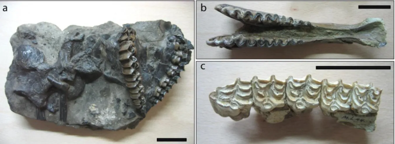
Figure 2: Three specimens of mammals from three Cenozoic localities from the Parc Naturel Régional
du Luberon stored at the Natural History Museum Basel. a, Skull of Palaeotherium curtum from La Débruge, late Eocene (NMB Db.31). b, Mandible of Plagiolophus huerzeleri from Murs, early Oligocene (NMB O.V.76b). c, Upper toothrow of Hipparion gracile from Cucuron, late Miocene (NMB M.L.44). Scale bar: 5 cm.
The Oligocene of the Parc du Luberon is also very rich in fossils, with an unsual variety of fossil forms. The diverse lacustrine sedimentary record allows different kinds of preservations, from jellyfishes preserved as imprints, to birds preserved with feathers (Mayr, 2005; Louchart et al., 2007), plants, amphibians, insects (Nel et al., 2008) mammals preserved as whole skeletons (bats, ruminants, Bouvrain & Geraads, 1985, or mammal footprints (Costeur et al., 2009). Several localities are largely known (e.g., the finds known under the name Céreste, see below) and others are unpublished or only partially described despite their good preservation state (e.g., Murs, Remy, 2000 and Fig. 2b).
The Miocene is also represented in the Parc du Luberon, mostly with the molassic sediments of the Early Miocene but a Late Miocene rich and characteristic
fauna, that of Cucuron (also known as Mont Luberon), was discovered in the 19th
century by A. Gaudry (REF). With a good record of many different mammals (rodents, antilopes, rhinos, elephants or lipothyphlans; Fig. 2c), Cucuron is one of the richest Late Miocene locality of Europe.
We will visit a couple of these Oligocene localities in the frame of the field trip (see Fig. 3 for the geological context of the localities).
Figure 3: Geographical and geological context of the 3 localities visited during the excursion.
Stars indicate the sites (Gignac, Viens and Céreste).
Field trip
Stop1: The Museum "La Maison du Parc" in Apt (Fig. 4a)
Apt is a small town and is an administrative city of the Vaucluse district. Apt was already a prosperous city during Roman times but the first settlements date back to 9000 years BC making the archaeological record around the city very rich. Today with a little more than 10000 inhabitants it is the portal to the touristic Luberon.
As the Parc is a protected area, an institution with scientists dedicated to increase the knowledge of the region was set up and a Museum was built to provide information on the Geology and Palaeontology to the public. We will first visit the small Museum
and explain the Geology, Palaeontology of the area together with the course of our field trip.
Figure 4: Pictures of the 4 stops of the excursion with examples of ichnofossils. a, The Museum "La
Maison du Parc" in Apt. b, the site of Gignac, note the syn-sedimentary parallel faults, and mammal footprints in the foreground. c, the Viens Quarry, viewed from the village of Viens, a few hundred meters away. d, the locality of Céreste in the famous "calcaires en plaquettes". e, Rhinoceros trackway on a limestone slab at the Viens Quarry, note three sets of pes-manus footprints. f, two even-toed ungulate footprints at Gignac.
Stop 2: The site of Gignac (Fig. 4b)
Gignac is one the best fossil site with mammal footprints to be seen in the world. The surface of several hundred squarre meters shows more than 400 footprints of even-toed ungulates (small ruminants, together with larger forms, possibly the suiform entelodontids, Fig. 4f) and rhinoceroses. Many of the footprints are organized in trackways sometimes totalling more than 20 meters in length (which is long for the record of mammal trackways). The site was first mentioned in the 60's (Bessonat et al., 1969) and was extensively published recently (Costeur et al., 2009). Together with the footprints, the site exposes syn-sedimentary micro-faults, whose centimeter-high walls are sometimes crushed by footprints testifying to the soft-sediment deformation. These structures are all aligned with the normal large Durance fault, 30 km to the East, and could be the result of seismic activity related to this accident.
Stop 3: The site of Viens (Fig. 4c)
The site of Viens is exposed in a quarry surmounted by the nice perched village of Viens. Several layers of calcareous limestones yielded mammal footprints, most probably always of Rhino affinities (Costeur et al., 2009). New excavations (done in April 2010; not yet undertaken at the time this paper is written…) should result in new findings. We will enlarge two outcrops that already yielded beautifully preserved rhino trackways (Fig. 4e). The site was previously known for a rhinoceros mandible (Ronzotherium velaunum) that was found in the 70's within the lacustrine limestones that compose the base of the quarry (Demathieu et al., 1984). Unfortunatly this specimen appears to have been lost. The base of the quarry records the very early Oligocene and the Eocene-Oligocene transition can be followed in the vicinity, which is pretty promising since this transition, the famous "Grande Coupure" of Stehlin (1909), sees a large renewal of the European faunas. The purpose of the field work in April 2010 is also to assess the palaeontological potential of this area. Stop 4: The site of Céreste (Fig. 4d)
Céreste is known worlwide for the numerous discoveries of various kinds (insects, plants, amphibians, bats, etc) which were also extensively excavated by amateurs before the protection of the Parc (this resulted in many private collections often with wonderful specimens). One knows "Céreste" as the common name for many finds made in the fine laminated lithostratigaphic limestones of the Parc, but several localities, besides Céreste itslelf, actually yielded fantastic fossils (including many extraordinary birds) such as:
- A complete skeleton of the Oligocene ruminant Bachitherium insigne from Vachères (Bouvrain & Geraads, 1985)
- A complete Oligocene hummingbird with modern feathering from a locality situated near the Viens quarry, called "Le Grand Banc" (Louchart et al., 2007).
- The first and only complete fossil Pelican beak (Louchart, com. pers.), a crane precurssor and a rare cuckoo all from Vachères (Mayr, 2005, 2006)
- An early Passeriformes (Mayr & Manegold, 2006).
The most common discoveries are the hundreds of complete fish skeletons (species
Dapalis macrurus) from several places in the lithographic limestones. The locality
Céreste itself we will be visiting is located in the middle Oligocene formation "Calcaires de Campagne-Calavon" and is an outcrop of lithographic limestones where fishes, insects, plants, vertebrates, bird feathers etc. were previously found.
Acknowledgement
The authorities of the Parc Naturel Régional du Luberon are warmly thanked for letting us excavate and show their resources to the participants of the 8th EAVP meeting. We thank the organizing committee of the 8th EAVP meeting for allowing us organizing this excursion.
References:
Aguilar, J.P., Legendre, S. and Michaux, J. (Eds.) 1997. BiochroM'97. Montpellier, Mémoires et Travaux EPHE.
Bessonnat, G., Dughi, R. and Sirugue, F. 1969. Un important gisement d'empreintes de pas de mammifères dans le Paléogène du Bassin d'Apt-Forcalquier. Comptes Rendus de l'Académie des Sciences, Paris 268, série D: 1376-1379.
Bonis, L. de 1964. Etude de quelques mammifères du Ludien de la Débruge (Vaucluse). Annales de Paléontologie, Paris t. L (2): 128-154.
Bouvrain, G. and Geraads, D. 1985. Un squelette complet de Bachitherium (Artiodactyla, Mammalia) de l'Oligocène de Céreste (Alpes de Haute-Provence). Remarques sur la systématique des ruminants primitif. Comptes-rendus des séances de l'Académie des sciences, Paris 300, Série 2: 75-78
Costeur L., Balme C. & Legal S. (2009). Early Oligocene mammal tracks from south-eastern France. Ichnos, 16 (4): 257-267.
Demathieu, G., Ginsburg, L., Guérin, C. and Truc, G. 1984. Etude paléontologique, ichnologique et paléoécologique du gisement oligocène de Saignon (bassin d'Apt, Vaucluse). Bulletin du Museum national d'Histoire naturel de Paris 6, 4e série, section C (2): 153-183.
Gervais, P. 1846. Observations sur les différentes espèces de mammifères fossiles du midi de la France. Annales des Sciences Naturelles, 3è série, t.5.
Lesueur, J.L. 1991. Etude sédimentologique et stratigraphique du bassin paléogène d'Apt-Manosque-Forcfalquier (Alpes de Haute Provence). Modalités de la Transgression burdigalienne. Unpublished Ph.D. Thesis, University Bordeaux 3. 424 p.
Louchart, A., Tourment N., Carrier, J., Roux T. and Mourer-Chauviré, C. 2007. Hummingbird with modern feathering: an exceptionally well-preserved Oligocene fossil from southern France. Naturwissenschaften 95 (2): 171-175.
Mayr, G. 2005. A chicken-sized crane precursor from the early Oligocene of France. Naturwissenschaften, 92: 389-393.
Mayr, G. 2006. A specimen of Eocuculus Chandler, 1999 (Aves, ? Cuculidae) from the early Oligocene of France. Geobios 39: 865-872.
Mayr, G. and Manegold, A. 2006. A small suboscine-like passeriform bird from the ealry Oligocene of France. The Condor 108: 717-720.
Nel, A., Prokop, J., Ross, A.J. 2008.New genus of leaf-mimicking katydids (Orthoptera: Tettigoniidae) from the Late Eocene–Early Oligocene of France and England. Comptes Rendus Palevol 7(4): 211-216.
Remy, J.A. 2000. Plagiolophus huerzeleri, une nouvelle espèce de Palaeotheriidae (Perissodactyla, Mammalia) de l'Oligocène inférieur (Rupélien, MP23) à Murs (Vaucluse, France). Geobios 33 (4): 489-503.
Stehlin, H.G. 1909. Remarques sur les faunules de Mammifères des couches éocènes et oligocènes du Bassin de Paris. Bulletin de la Société Géologique de France 9: 488-520.
Truc, G. and Demarcq, G. 1967. Eocène supérieur et Oligocène de Péréal (La Débruge-Sainte-Radegonde, près Apt, Vaucluse). Bulletin de la Société géologique de France IX(7): 504-510.