E E D E N
E E D E N
Environments and Ecosystem
Dynamics of the Eurasian Neogene
Birth of the New World
Birth of the New World
Stará Lesná, Slovakia Nov. 12-16, 2003
Univerzita Komenského Bratislava, November, 2004
Preface
By Meulenkamp, J. & Fortelius, M.
A programme on Environments and Ecosystem Dynamics of the Eurasian Neogene (EEDEN) was funded by the European Science Foundation in 2000 for a five-year period. Its ultimate ambition is to arrive, through promoting truly multidisciplinary collaboration and exchange of information, at a “total system view” of the processes that controlled terrestrial ecosystem change in the Neogene. It is focussed in particular on understanding three high-resolution intervals, centred around 15, 10 and 5 million years ago, respectively. The previous plenary meetings have taken place at Lyon (2000: State of the Art), Sabadell (2001: Late Miocene to Early Pliocene Environments and Ecosystems), and Frankfurt (2002: The Middle Miocene Crisis).
The EEDEN plenary meeting of 2003 at Stara Lesna has as its topic the second of the high-resolution intervals and as its title Birth of the Modern World. The title refers to the fact that the beginnings of essentially modern palaeogeographic and climate systems were established at this time. The process was accompanied by major reorganisation of terrestrial ecosystems, abrupt and accompanied by mass extinction in some cases (in particular the “Vallesian Crisis” that strongly perturbed the mammal communities of western Europe), more gradual and without evidence of system collapse in others. A main question remains to what extent physical environmental forcing was directly responsible for the regional differences observed, and to what extent they reflect intervening evolutionary processes in the ecosystems. The meeting is designed to cover all the evidence that can be brought to bear on the second high-resolution interval and more generally on the central EEDEN questions of palaeoenvironment reconstruction and the evolutionary dynamics of terrestrial ecosystems on geological time scales.
Astronomically forced climate change in Late Miocene shallow lacustrine and
distal alluvial fan sequences from the Teruel Basin
Aziz, H. A.1,2 & Abels, H.2 & Calvo, J.P.3 & van Dam, J.2 & Hilgen, F.J.2 &
Krijgsman, W.1
1Paleomagnetic Laboratory “Fort Hoofddijk”, Utrecht University, Budapestlaan 17, 3584 CD Utrecht, The
Netherlands, tel +31(0)30 2535246, fax +31(0)30 2531677, e-mail [email protected], 2Department of Geology,
Faculty of Earth Sciences, Utrecht University, The Netherlands, 3Facultad Ciencias Geológicas, Universidad
Complutense, Madrid, Spain
An integrated stratigraphic and petrographic study of cyclically bedded distal alluvial fan to lacustrine/palustrine deposits in the late Miocene continental sections of Cascante and Cańizar (Teruel basin, NE Spain) is presented. The cyclostratigraphic analysis reveals that different scales of sedimentary cyclicity are present which have a ratio of about 1:2:5. Spectral analysis of colour records in the depth domain shows the presence of a significant peak at ~2.2 m, which corresponds to the average thickness of the basic small-scale, mudstone-carbonate, cycle. Other peaks correspond to the large-scale cycle, which consists of clusters of 5 basic cycles, and to a cycle twice the average thickness of the basic cycle. Magnetostratigraphic results, in combination with small-mammal biostratigraphy, indicate that the three normal polarity intervals recorded in our sections correspond to C5n.2n, C5n.1n and C4Ar.2n. However, using the CK95 ages for the polarity reversals implies a significant change sedimentation rate throughout the studied interval, which is not in agreement with the regularity of the sedimentary cyclicity. Spectral analysis results of high-resolution colour records in the time domain produce a spectrum that is very consistent with Milankovitch climate forcing, if several age tie-points are excluded. Consequently, we have calculated the astronomical durations for C4Ar.2n (87 kyr), C4Ar.3r (54 kyr), C5n.1n (141 kyr), and C5n.1r (33 kyr), which show significant discrepancies with CK95. The duration pattern of our polarity intervals is confirmed by many detailed magnetostratigraphic records from the ocean floor, indicating errors in the reversal ages of CK95.
The great variety in the internal build-up of the carbonate beds complicated establishing phase relations between the sedimentary cycles with eccentricity thereby hampering a reliable tuning of the cycles to the astronomical curves. Therefore, to better understand the origin and nature of the different types of carbonates and, subsequently, to determine the phase relations we performed a detailed microfacies analysis of the carbonates. Our results indicate that carbonate beds from the lower part of the Cascante section were deposited in a very shallow ‘unstable’ lake, which was subjected to extensive subaerial exposure. Based on the relative depth and energy of the lake system, several sub-facies can be distinguished varying between relatively wet to relatively dry. Carbonates from the upper part of the section were deposited in a shallow ‘stable’ lake, which underwent only minor subaerial exposure. Also in this facies a distinction can be made between wet and dry sub-facies. Using these petrographic results, we can determine the phase relation between the sedimentary cycles and the astronomical parameters. Carbonates where deposited during precession minimum, however, the wet sub-facies type from both ‘stable’ and ‘unstable´ lake sub-facies formed during eccentricity maximum while the dry sub-facies types during eccentricity minimum. An astronomical tuning of the cycles is presented and shows a good fit with our petrographic interpretations. Most obvious is the shift from ‘unstable’ to ‘stable’ lake environments starting at around 9.67 Ma, which seems to be related with the long term (2.1 Ma) eccentricity cycle. At present, detailed petrographic, cyclostratigraphic and small-mammal biostratigraphic studies from parallel sections in the study area are being carried out.
The evolution of the Vallesian Crisis
Agustí, J.
Institute of Paleontology M. Crusafont 08201-Sabadell. Spain.
The Vallesian Crisis was first recognized by Agustí & Moyŕ-Solŕ (1990) in the Vallčs-Penedčs Basin, being considered as a one of the main events that affected the Eurasian mammalian faunas in the late Miocene. The Vallesian Crisis was characterized by the sudden extinction of a number of taxa which characterized most of the early and middle Miocene. Among other large mammals, the Vallesian Crisis involved the disappearance of most of the humid elements that characterised the middle Miocene and early Vallesian faunas from Western Europe. This crisis particularly affected several groups of perissodactyls, such as rhinoceroses (Lartetotherium sansaniense, “Dicerorhinus” steinheimensis) and tapirs. Among the artiodactyls, the high diversity attained by the suids in the early Vallesian times suddenly dropped and several characteristic elements such as Listriodon, Schizochoerus and the tetraconodontines Conohyus and Parachleuastochoerus became extinct as well. The Vallesian Crisis also involved the final decline of the middle Miocene forest community of cervids (Amphiprox) and moschids (Hispanomeryx) and the spread of the boselaphine bovids like
Tragoportax, which replaced their semiaquatic relatives of the genus Protragocerus (Köhler,
1993). Another group that was severely affected by the Vallesian Crisis was the large carnivores of the families Nimravidae (Sansanosmilus) and Amphicyonidae (Pseudarctos
bavaricus, Amphicyon major, Thaumastocyon dirus). Their extinction was partly compensated
with the entry of Paramachairodus, a new genus of machairodontine cat. Among the rodents, the Vallesian Crisis involved the disappearance of most of the hamsters (cricetids) and dormice (glirids) of early or middle Miocene origin (Megacricetodon, Eumyarion,
Bransatoglis, Myoglis, Paraglirulus, Eomuscardinus), flying-squirrels (Albanensia, Miopetaurista) and beavers (Chalicomys, Euroxenomys). In Western and Central Europe this
event coincided with the first dispersal of the murid rodents, the family that include the living mice and rats. After their entry into Europe, this group became the dominant rodents in the late Miocene communities and diversified into a number of genera: Progonomys,
Occitanomys, Huerzelerimys, Parapodemus.
Since that time, considerable progress has been done regarding the dating and timing of the Vallesian Crisis (Agustí et al., 1997 and 1999) as well possible causes for such crisis (Agustí et al., 2003). However, question remains about the extent of the Vallesian Crisis outside Western Europe.
References
Agustí, J. & Moyŕ Solŕ, S. (1990): Mammal extinctions in the Vallesian (Upper Miocene).Lecture Notes in Earth Science, 30: 425 432. Berlin Heidelberg.
Agustí, J., Cabrera, L., Garcés, M. & Parés, J.M. (1997): The Vallesian mammal succession in the Vallés Penedés basin (northeast Spain): Paleomagnetic calibration and correlation with global events. Paleogeogr. Paleoclim. Paleoecol., 133 (3-4): 149-180.
Agustí, J., Cabrera, L., Garcés, M. & Llenas, M. (1999): The late Miocene terrestrial record in the Vallčs-Penedčs Basin: Mammal turnover and Global climate change. In Agustí, J., Rook, L. & Andrews, P. (Eds.): The Evolution of Neogene Terrestrial Ecosystems in Europe. Cambridge University Press. Agustí, J., Sanz de Siria, A. & Garcés, M. 2003. Explaining the end of the hominoid experiment in Europe.
Distribution patterns of foraminifera in Late Miocene eastern mediterranean
sediments in relation to Environmental gradients: first results
Drinia, H.1 & Antonarakou, A. & Dermitzakis, M.D.
1National and Kapodistrian University of Athens, Department of Geology, Section of Hist.
Geology-Paleontology, Panepistimiopolis, 157 84 Athens-Greece, e-mail: [email protected]
In this work, the succession of paleoenvironments and foraminifera assemblages are analyzed from two sections (Ah Giannis, Bo) from the Lower Tortonian in Gavdos Island, which forms the southernmost extension of the South Aegean Island Arc. The main objective of the present study is to gain a better understanding of the environmental factors controlling the distribution of faunal parameters. The paleoecological approach uses the available data on recent foraminiferal assemblages from the Mediterranean (see review in Murray, 1991). These ecological characteristics of foraminifera can provide assessments, at varying levels of accuracy of water depth, bottom water oxygenation, salinity.
To reach our goal, quantitative and statistical analysis on benthic foraminiferal assemblages were carried out. Foraminiferal data are compared to others micropaleontological data. A data set, constituted by counted samples of benthic foraminifera, has been subjected to cluster and principal component analyses, in order to demonstrate the linkage between taxa distribution and paleoenvironmental gradients.
The most important benthic constituents are biconvex Cibicides, Uvigerina, elongate
Bolivina, Bulimina, Globobulimina (Praeglobobulimina), V. complanata and O. umbonatus
and represent a typical deep-sea mud dwelling assemblage. Associations largely made up of these groups are found today in normal marine environments with a muddy substrate, at depths below 100 m and with bottom temperatures lower than 10o. White marls are
characterized by well distributed high diversity of benthic species indicating stable environmental conditions. On the other hand, Ammonia beccarii is a very common foraminiferal species, which grows in almost every brackish or shallow marine environment, form the tropic to temperate regions.
Our results suggest that oxygenation and trophic conditions of the near-surface sediments are the most important factors that control the community structure of the benthic foraminiferal fauna. In addition, upwelling phenomena evidenced by signals from the benthic foraminifera may have played a role in the study area.
References
Late Miocene to Pleistocene paleoclimatic changes in eastern mediterranean
Antonarakou, A.1 & Hilgen, F. J.2 & Lourens, L. J.2 & Zachariasse, W.J.2
1University of Athens, Department of Geology, Panepistimiopolis, 157 84, Athens-Greece, 2Department of
Geology, Utrecht University, Budapestlaan 4, 3584 CD Utrecht, The Netherlands, e-mail: [email protected]
The Mediterranean sediments are very sensitive in recording astronomically induced oscillations of climate, due to its latitudinal position in combination with its semi-enclosed basin configuration. The astronomical calibrated time scales, which were constructed for the Pliocene-Pleistocene (Hilgen, 1991a,b) and extended into the Miocene (Krijgsman et al., 1995) provided a solid basis for unraveling relationships between orbital forcing and climatic proxy records in the Late Miocene-Pliocene-Pleistocene (Lourens et al., 1992, 1996).
High-resolution planktonic foraminiferal records are presented in order to reconstruct the climatic history of the Eastern Mediterranean Basin during the time span of 9.7 to 1.2 Ma. The sections selected for this presentation is the Rosselo section, covering the entire Pliocene, the Singa section for the Upper Pliocene-Lower Pleistocene, Singa section for the Late Pleistocene and Metochia section for the Upper Miocene.
Quantitative and qualitative modifications of the planktonic foraminiferal communities observed in the sections exhibit a sequence of bioevents, defined by frequency peaks and/or local (re)-occurrences or (temporary) disappearances of some of the taxa, in association with more or less important fluctuations of the more common species.
The majority of the foraminiferal species are sensitive indicators of paleoenvironmental changes. Proxy records for Sea Surface Temperature (SST) and Sea Surface Productivity (SSP) were determined considering the foraminiferal assemblages and the relative abundance of each species as indicators of particular environmental conditions.
Spectral analysis has been carried out in all records in order to establish short-term variations and the possible influence of astronomical forcing.
References:
Hilgen, F.J., 1991a. Astronomical calibration of Gaus to Matuyama sapropels in the Mediterranean and for the Geomagnetic Polarity Time Scale. Earth Planet. Sci. Lett., 104, 226-244.
Hilgen, F.J., 1991b. Extension of the astronomically calibrated (polarity) time scale to the Miocene/Pliocene boundary. Earth Planet. Sci. Lett., 107, 349-368.
Lourens, L.J., Hilgen, F.J., Gudjonsson, L. & W.J. Zachariasse, 1992. Late Pliocene to early Pleistocene astronomically forced sea surface productivity and temperature variations in the Mediterranean. Mar.
Micropaleontol., 19, 49-78.
Hilgen, F.J., Krijgsman, W., Langereis, C.G., L.J., Lourens, Santarelli, A. & W.J. Zachariasse, 1995. Extending the astronomical (polarity) time scale into the Miocene. Earth Planet. Sci. Lett., 136, 495-510.
Lourens, L.J., Antonarakou, A., Hilgen, F.J., van Hoof, A.A.M., Vernaud-Grazzini, C. & W.J. Zachariasse, 1996. Evaluation of the Plio-Pleistocene astronomical time scale. Paleoceanography,11, 4, 391-413.
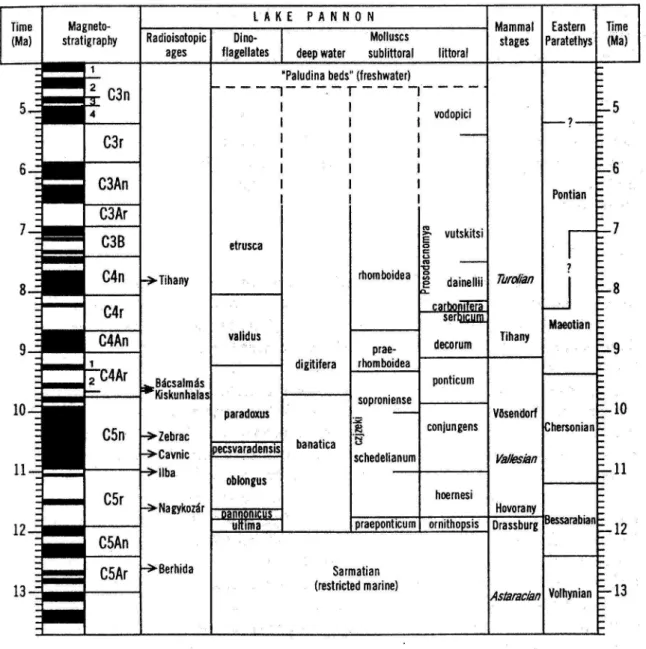
Pannonian organic-walled phytoplankton assemblages in Croatian part of
Pannonian Basin
Bakrač, K. & Pavelič, D. & Kovačič, M. & Miknič, M. & Avanič, R. & Vrsaljko, D.
Institute of Geology, HR-10000 Zagreb, Sachsova 2, Croatia; e-mail: [email protected]
The eastern Croatia was a part of the southern margins of Central Paratethys during the Miocene (Fig.1).
Palynological analyses were carried out on the sediments from the surface profile at locality Vranović near Našice, in order to define the boundaries between local formations: Kasonja Formation (Sarmatian), Croatica Formation (lower Pannonian), and Pavlovci Formation (middle Pannonian).
Following the end-Badenian initial isolation brachihaline fauna began to evolve in the Pannonian Basin. Although some deepening occurred during the Sarmatian, its end was characterised by shallowing. The findings of molluscs Ervilia disita disita,
Mactra podolica and Irus sp., define
Sarmatian age of sediments. Palynomorph assemblages consist of marine dinocysts tolerant to decreased salinity: Hystrichosphaeropsis obscura, Polysphaeridium zoharyi, Lingulodinium
machaerophorum, and brackishdinocysts Spiniferites bentori budajenoensis. This assemblage is also typical for the Late Sarmatian deposits in Hungary (Sütő-Szentai, 1988).
In the Early Pannonian, salinity was very low, and the environment became oligohaline, locally even fresh. Such environmental conditions enabled the expansion of endemic species. Macrofauna is dominated by Radix croatica and Gyraulus praeponticus, indicating Early Pannonian age ("Croatica-beds"). The deposits consist of lacustrine littoral to sublittoral limestones with marl intercalations. Ecological conditions were unfavourable for dinoflagellates, which is evident by absence of dinocysts in these sediments. Consequently, prasinophyts Mecsekia ultima, Mecsekia spinosa and Mecsekia incrassata dominate the phytoplankton assemblages.
Salinity increased and the basin became brackish again. Massive marls were deposited in a deeper part of the lake. The fossil association includes shells of Congeria banatica indicating the middle Pannonian ("Banatica-beds", Pavlovci Formation). The lake bottom was bioturbated due to activity of benthic organisms. The dinocyst assemblage of Spiniferites
bentori pannonicus, Spiniferites bentori granulatus, and Impagidinium spongianum
characterizes these deposits, which can be correlated with the assemblage of Spiniferites
bentori pannonicus zone in Hungary (Sütő-Szentai, 1988). Within the succeeding deposits, Spiniferites bentori pannonicus, Spiniferites bentori oblongus dominate the palynomorph
assemblages. Nematosphaeropsis sp. and membranous forms of Spiniferites bentori indicate water-level rise and a distal environment. This assemblage is similar to the assemblage of
Spiniferites bentori oblongus zone from Hungary (Sütő-Szentai, 1988).
Fig. 1 Geographical features of the Pannonian basin. The modern basin area is shaded; outcrops of the basement (mostly Mesozoic and older) are white. (Magyar, I. et al
In conclusion, the sedimentation during the Late Sarmatian and Pannonian was continuous, and the dinoflagellate zones are correlative within Croatian and Hungarian part of the Pannonian Basin.
References:
Magyar, I., Geary, D.H. and Müller, P., 1999. Paleogeographic evolution of the Late Miocene Lake Pannon in Central Europe. Palaeogeography, Palaeoclimatology, Palaeoecology 147, pp. 151–167.
Sütő - Szentai, M. (1988): Mikroplankton zones of organic skeleton in the Pannonian s.l. stratum complex and in the upper part of the Sarmatian strata.- Acta Botanica Hungarica, 34 (3-4), 339-356.
Some Recent Advances in Understanding Old World Hipparionine
Evolution, Biogeography and Paleoecology
Bernor, R. & Kaiser, T. & Scott, R. & Woodburne, M.O.
Raymond L. Bernor, College of Medicine, Department of Anatomy, Laboratory of Evolutionary Biology,
Howard University, 520 W St. N.W., Washington D.C. 20059;Email: [email protected]. Thomas Kaiser,
Institute and Museum of Zoology, University of Greifswald, D-17489 Greifswald, Germany; e-mail:
[email protected], Robert Scott, Department of Anthropology, University of Texas, Austin, Texas
78712-1086, USA; email: [email protected] ,Michael O. Woodburne, Department of Earth Sciences,
University of California, Riverside, 92521; [email protected]
Hipparionine horses arose by 16 Ma in North America, evolved there until circa 4 Ma., and succeeded in making a broad and rapid prochoresis into Eurasia and Africa arguably between 11.1 and 10.7 Ma. Research on these hipparions over the last 30 years have led to the recognition of several superspecific groups and multiple geographically and chronologically defined lineages across all of Holarctica and Ethiopia.
Woodburne has recently undertaken the further resolution of the North American
Cormohipparion group identifying C. goorisi as the earliest member of the clade. Cormohipparion goorisi first occurs in the early Barstovian Trinity River Pit fauna of Texas,
dated at about 15.5 Ma based on biochronology. It is characterized by having the
Cormohipparion signature of a large and strongly demarcated DPOF, with its anterior end
very near the IOF; wide POB, and lacrimal that extends within the rear of the DPOF (retracted in more evolved species). Cormohipparion goorisi differs from other species of the genus in its smaller overall size and more mesodont dentition wherein the upper cheek tooth enamel pattern is less complex, and protocone more ovate. Cormohipparion quinni is known from late Barstovian Valentine Formation faunas of Nebraska, dated at between 14-13 Ma on radioisotopic and faunal grounds. Cormohipparion quinni is larger and more hypsodont than
C. goorisi, has a more complex upper cheek tooth enamel pattern, a shorter dP1 relative to P2,
stronger lower cheek tooth protostylids, better separated p2 metaconid-metastylid, and a less strongly pocketed DPOF. The Cormohipparion occidentale group ranges throughout the Clarendonian (ca 12.5 – 9 Ma). Studies underway suggest that this group contains as many as six species, all of which are larger and contain more complex cheek tooth dentitions than C.
quinni, a much reduced dP1, and a more ovate rather than tear-drop shaped DPOF.
Preliminary studies suggest that a species of Cormohipparion from the early Clarendonian MacAdams Quarry, Texas (ca 12 Ma) is a likely candidate for the ancestry of the Old World
Hippotherium (‘Hipparion’) Datum.
It has been a long-held supposition that the first occurring Old World hipparion was
Hipparion primigenium. Recent research on the Hőwenegg (Hegau, Germany) MN 9
assemblage of 14 skeletons has provided detailed anatomical information, and revealed that this and other similar Central European hipparions are best referred to the genus
Hippotherium, not Hipparion; hence, our referral to the species Hippotherium primigenium.
There are a number of skeletal characteristics of the skull, dentition, axial and postcranial skeleton that support this referral.
Hippotherium primigenium was pervasive through the Vallesian and Early Turolian of
Central Europe, and would appear to occur in early MN9 of Western Europe. However, our recent work in the late Miocene sequence, and particularly the MN9 interval of Sinap, Turkey, has revealed that the first occurring hipparion there is referable to Cormohipparion sinapensis. Our extensive morphometric analyses of the Sinap hipparion assemblage have revealed that they underwent an extensive evolutionary radiation within MN9, with upward of 4 to 5 species occurring at the end of the interval within the local section. Morphologic diversity is
found particularly in facial, snout and postcranial anatomy of this assemblage. This radiation included species of Cormohipparion and “Hipparion” and is most likely relevant to the evolution of the multispecific genera, Hipparion s.s and Cremohipparion.
We have also recently studied a small assemblage of hipparions from MN 9 correlative horizons of Chorora, Ethiopia. Chronologic and biostratigraphic information suggests an age of between 10.7 and 10.0 Ma. We have referred this assemblage to “Cormohipparion” sp., and have recognized that more complete skull and postcranial material will be needed to attain a secure species-level identification. Analysis of the cheek tooth mesowear however has revealed that this horse was a mixed feeder that incorporated C4 grass into its diet.
By the earlier Turolian it would appear that there were several multi-species lineages in place: Hippotherium, Hipparion s.s., Cremohipparion, Sivalhippus and Eurygnathohippus. These lineages had distinct morphologies and well defined biogeographic ranges. The basal Pliocene witnessed the apparent extinction of all these lineages except for Eurygnathohippus in Africa, which continued to evolve in adaptation to African grasslands. The “Sivalhippus” Complex evolved advanced multispecific lineages of Plesiohipparion and Proboscidipparion and extended their range from Asia into Europe.
Finally, we discuss further here our current work on the medial Turolian species diversity of hipparions at Samos (Greece), the extension of late members of the Hippotherium
primgenium lineage from the Central Paratethys into Tuscany, and a lineage of tiny hipparions
Migration history of air-breathing fishes reveal Neogene atmospheric
circulation pattern
Böhme, M.
Department of Geo- and Environmental Science, Section Palaeontology, University Munich,
Richard-Wagner-Str. 10, D-80333 München. E-mail: [email protected]
The migration history of an Old World air-breathing fish group (Channidae; snakehead fishes) is used for reconstructing Neogene Eurasian precipitation and atmospheric circulation pattern. It could be shown that snakeheads are sensitive for summer precipitation maxima in subtropical and temperate regions and occur regularly if the wettest month exceed 150 mm precipitation and 20°C mean temperature. The analysis of 515 fossil freshwater fish deposites from Africa and Eurasia of the last 50 Myr show two continental scale migration events from their centre of origin in the South Himalayan region, which can be related to changes in the Northern Hemisphere circulation pattern.
The first migration at ~17.5 Myr into Western and Central Eurasia correlates with an northward shift of the Innertropical Convergence Zone (ITCZ) bringing Western Eurasia under the influence of trade winds which produced a zonal and meridional precipitation gradient in Europe. During the second migration between 8 and 4 Myr into Africa and East Asia snakeheads reached their present day distribution. This could be related with the intensification of the Asian monsoon bringing summer precipitation to their migratory pathways in East Africa/Arabia and East Asia.
Tortonian climate patterns in Europe based on plant-proxy data - and its
development since Middle Miocene
-Bruch, A. A. & Utescher, T. & Olivares, Ch. A. & Mosbrugger, V. & NECLIME members
Institut und Museum für Geologie und Paläontologie, Sigwartstrasse 10, 72076 Tübingen (Germany), e-mail:
An extended dataset of 42 late Neogene micro- and megafloras (~11-7 Ma) from Europe and western Asia was combined from data of Bruch et al. (in press), Olivares et al. (in prep.), and new climate data for additional localities. It is analysed with respect to various climate variables using the Coexistence Approach. The results are presented in maps showing spatial temperature and precipitation patterns and seasonal components.
In the time span between 11 to 7 Ma, mean annual precipitation (MAP) rates of over 1000 mm are observed in a region extending from NE Spain in the West to the Eastern Mediterranean, Anatolia and Armenia in the East, thus confirming the results of Bruch et al. (in press) where humid conditions all over Central Europe and the absence of major precipitation gradients are reported. Slightly lower MAP rates (<900 mm) result for a locality in western Central Spain, substantially dryer conditions, however, with MAP below 750mm are only reported from pollen localities in Northwestern Africa, so far (Suc, pers. comm.). As shown by the analyses of the precipitation rates in the wettest and driest month, respectively, rainfall was not distributed homogenously throughout the year. The observed spatial pattern of seasonal aridification is well in accordance with results obtained from the analyses of small mammals showing almost the same regional trends for the time-span between 10 to 8 Ma (Van Dam, in press). The precipitation rates in the warmest month always exceeds the values for the driest month.. This contradicts the presence of a Mediterranean type climate with summer drought in the time interval regarded. The establishment of seasonally drier conditions observed in the lower latitudes of Europe most probably can be referred to the pronounced cooling at the beginning of the late Miocene leading to a reduction of atmospheric moisture in southern regions.
The ongoing reconstruction of climate maps for the Langhian/Lower Badenian and Serravallian/Sarmatian time slices will give more information about the development of climate patterns in time, showing the low temperature and precipitation gradients throughout the Middle and late Miocene in Central Europe, and an increasing seasonality on both, temperature and precipitation parameters.
References
Bruch, A.A., Utescher, T. Mosbrugger, V., Gabrielyan, I., Ivanov, D.A., in press: Late Miocene terrestrial climate in the circum-Alpine realm - a quantitative palaeobotanical analysis. Palaeogeography, Palaeoclimatology, Palaeoecology.
Van Dam, J., in press, Geographic and temporal patterns in the late Neogene (12-3 Ma) aridification of Europe. The use of small mammals as paleoprecipitation proxies. Palaeogeography, Palaeoclimatology, Palaeoecology.
Alcalde Olivares, C., Bruch, A.A., Maldonado Ruiz, J., Mosbrugger, V. (in prep): The history of climate during the Neogene in the Iberian Peninsula.
The project WINE and its goals
Doukas, C. S.
Dept. of Paleontology, University of Athens, Panepistimiopolis GR-157 84, Athens, Greece e-mail:[email protected]
The study of insectivores is reflected in individual work that gives emphasis either on systematics, or phylogeny, or ecology, or all of the above. That is why in November of 2002, European insectivore specialists gathered together in Frankfurt am Main to talk about giving insectivores a high profile and work in cooperation in solving the problems concerning this group. We decided then to work together on the Neogene insectivores, retaining the classic division, starting from the E. Miocene to the Villanian/Biharian boundary. Although most of our material comes from European localities, we thought that in order not to get biased information on migration, it would be best to include Asia. We have called our project WINE, Workgroup on Insectivores of the Neogene of Eurasia. Insectivores are the oldest placental mammals. Thinking of them, however, as primitive mammals is wrong because they combine a mixture of primitive and derived characters. Insectivores recently have been called Lipotyphla. However, this systematic has been proved to be useless to paleontologists. Presence or absence of “caecum” can not be detected in our fossils and the phylogeny of the group shows that only a part of the families can be assigned to Lipotyphla. Therefore our first decision was to return to the good old name of “insectivores “. However, previously the term “insectivores”, was used as a waste basket referring to unclear definition. Now we understand “insectivores” as a covering umbrella. Following this train of thought and in order not to create havoc in systematic we retain the subdivision suggested by BUTLER (1972): Erinaceomorpha and Soricomorpha. By doing this we eliminate the question of “Lipotyphla” which becomes a supraordinal taxon. During the Neogene lived all the extant families, Erinaceidae (hedgehogs), Talpidae (moles), Soricidae (shrews), Selonodontidae (solenodons), Chrysochloridae (golden moles) and Tenencidae (tenrecs), plus two extinct now families Plesiosoricidae and Dimylidae (ZIEGLER 1999). Dimylidae should be referred to Soricomorpha. Even though, insectivores are usually less abundant than rodents in fossil small mammal assemblages, valuable collections of good material in dental and post-cranial elements exist. In the study of insectivores the use of post-cranials is also important. We have set as our first goal to gather and publish a fossil record of the Neogene insectivores which contains for every known locality, next to a fauna list, local stratigraphy, plus coordinates when available, MN zones, a reference list and place of storage of the material. This publication is expected to come out in 2004 by “Scripta Geologica” (Leiden, NL). Colleagues from Austria, the Czech Republic, France, Germany, Greece, Holland, Poland, Spain, Switzerland and Ukraine are participating in this volume. With our first step, the fossil record, we are addressing the stratigraphic problem, mainly referring to local zonation. This is essential to be able to correlate to the MN zones. It has been proven that correlation to MN zones becomes problematic when you are geographically distant from the reference fauna and the local succession is not well known. After completing our fossil record, working groups should be formed, to work on mainly phylogeny and consequently to the other topics. Phylogenetic lineages, geographical patterns and in turn migration routes, should be studied. Knowledge of geographical boundaries is also important Insectivores are good ecological markers in the study of a fauna. Biostratigraphy information is normally taken from the rodent assemblages. For the understanding of ecosystems today, modeling is “on vogue”, not without a reason. Distribution and abundance of species can help in the reconstruction of humidity and temperature, or even more, in the seasonal aspects of climate. Small mammals,
consequently insectivores, are good due to their short mean life expectancy, in calculating interannual variation.
Vegetation reconstruction in West Eurasia during the interval 12 to 8 m.a. (HRI
2) based on the plant record and the taxonomic/physiognomic evaluation
approach.
Paraschiv, V. & Kovar-Eder, J.
Dept. Geology and Palaeontology, Fac. Geology and Geophysica Univ. Bucharest, Nicole Balcescu Ave, no 1, Sct. 3, 70111 Bucharest (Romania), email: [email protected], Staatliches Museum für Naturkunde Suttgart, Rosenstein 1, 70191 Stuttgart (Germany), email: [email protected]
The taxonomic/physiognomic evaluation approach is based on a taxonomic/physiognomic grouping of plant taxa that additionally reflects major sociological components in the fossil record. This method, which was introduced in 2001 in Prag (Kovar-Eder & Kvaček 2003), has meanwhile been applied to plant assemblages of the intervals 17 -14 m.a. (HRI 3) and 7-4 m.a (HRI 1). Here we present the results for the interval 12-8 m.a. (HRI 2) where, for the first time, we include also fruit- and, pollen assemblages.
Independent dating of the plant assemblages is one of the most essential prerequisits for our evaluation. Moreover, only floras with more than 10 woody zonal (hinterland) taxa are included to minimize the influence of azonal (mainly wetland) taxa in the overall picture. Different attempts were performed: using plant assemblages from fissile sediments (so-called leaf assemblages, they include also associated, mostly winged, fruit taxa), and from sievable sediments (fruit and pollen assemblages). Reliably calibrated plant assemblages that are published in detail are available richest from fissile sediments (36) but are far less numerous from sievable sediments (fruits 8, pollen 15).
First the records of the different ogan assemblages were evaluated separately because their fossilisation is biased by different taphonomic factors.The respective results were compared then. The pictures for the different components in the leaf and the pollen record match rather well, e.g. both in the leaf- and pollen record the same trends in the region Central Europe / SE-Europe are evident regarding the broad leafed deciduous (BLD) and broad-leafed evergreen (BLE) components.
The picture provided by the fruit record ist too spotty to recognize trends. It appears less consistent with the leaves and pollen, although this may be an artifact due to the scanty fruit record. In the sclerophyll (SCL) component the consistency in percentages is well between the fruit, leaf, and pollen record. However, in the leaf record, there is a trend towards slightly increased values in SE-Europe versus Central Europe visible which is not evident from the pollen record.
For the Rhine Embayment the leaf and fruit records (BLD, BLE, and SCL+LEG (legume-like) components) are less consistent among each other than in other European regions. This fact has already been recognized earlier.
In our final attempt we fused all the records of the different organ assemblages. These maps show complementary north/south gradients both in the BLD and BLE components, and a trend towards slightly increased values of the SCL+LEG component southwards. The ratio (BLD+BLE)/(SCL+LEG) which may serve as indicator of humidity shows also a north/south gradient with higher values towards the north. The Rhine embayment can be recognized as humid region with higher values of the BLE component than in Central Europe but low values of the SCL+LEG component comparable to those in Central Europe.
Compared to the results for HRI 3 distinct differences can be stated in the percentages of the different components in Central Europe: lower values of the BLD component and higher ones
of the BLE, and especially the SCl+LEG components for the HRI 3. The eventual strong meridional gradient in Central Europe cannot be traced in the HRI 2. The results provided for the latter interval are closer to those elaborated for HRI 1. The humidity gradient (higher values in the north than in the south) seems weaker in HRI 1, indicated by the percentage of the SCL+LEG component. Anyway, it has to be kept in mind, that for HRI 3 and HRI 1 we have used the leaf record only and still have to include the fruit and pollen record.
References:
Kovar-Eder, J. & Kvacek, Z. (2003). Towards Vegetation Mapping Based on the Fossil Plant Record. Acta Universitatis Carolinae, Geologica, 46/4: 7-13.
Mammal community structure & primate dynamics during late Neogene
Eronen, J.1 & Rook L,. 2 & Fortelius, M.1
1 University of Helsinki, Department of Geology, PO Box 64, 00014 Helsinki (Finland), E-mail:
[email protected],2 Dipartimento di Scienze della Terra, Univ. di Firenze , Via G. la Pira 4, 59121
Firenze (Italia)
We used a dataset from the NOW – database (http://www.helsinki.fi/science/now) to investigate how primates reacted to changes in humidity Europe. The results show that the distribution of primates followed the distribution of humid areas through time. A comparison between primate and non-primate localities shows differences in mammalian community structure between 11,2 Ma (MN9) and 3,4 Ma (MN15) ago, an interval that includes HRI 1 and 2.
A major change affecting the distribution pattern and occurrence context of primates took place within HRI 2. In the time slice 11,2-9,5 Ma (MN9) the distribution of primate localities in Europe was the widest during the entire Neogene. The whole mammal community was homogenous and almost no regional differences can be distinguished in humidity or community structure. In time slice 9,5-9,0 Ma (MN10) differences between East and West begin to appear. The distribution of primates is restricted to few localities, but no differences can be seen in community structure between primate and non-primate localities. The differences between East and West were greatest about 9,0-8,2 Ma ago (MN11).
After this the East-West contrast faded and instead a contrast began to develop between South and North. Hominoids were restricted to Mediterranean environments and the more terrestrially adapted cercopithecoid genus Mesopithecus was found in humid habitats throughout Europe. In time slice 8,2-7,1 Ma (MN12), when the differences in community structure between primate and non-primate localities became clearer, Mesopithecus was restricted to localities in Italy, the Balkans and Greece, close to water-bodies.
About 7,1-5,3 Ma ago (MN13) the hominoid primates disappeared, Mesopithecus was restricted to humid areas in central Europe, Italy and Greece, and we see the first appearance of the genus Macaca in Europe. Macaca is very flexible in it’s habitat preferences and is known first from a relatively dry area in Spain. The community structures are very different in primate and non-primate localities. The primate localities have mammal communities consisting mainly of browsers and mixed feeders, indicating a relatively closed habitats. The non-primate localities have communities consisting mainly of grazers and mixed feeders, indicating more open-habitats.
In the time period 5,3-3,4 Ma ago (MN14-15), humid conditions returned to most of Europe and we see the appearance of Dolichopithecus (MN14) and Paradolichopithecus (MN15). The distribution of primates covered most of Europe. Also the community structure of non-primate and non-primate localities was again quite similar, reflecting in part a rise in the relative proportion of browsers in latter time period (MN15).
Evolution of the vegetation diversity in the Mediterranean region during the
Neogene: Quantification method based on pollen data
Faquette, S.1 & Suc, J-P.2 & participants to the IFB project
1UMR CNRS 5125, Paléoenvironnements et Paléobiosphčre, 2 Université Claude Bernard – Lyon 1, Boulevard
du 11 Novembre, 69622 Villeurbanne cedex, France
In the framework of a program of the French Institute for Biodiversity (IFB), we attempt to quantify the evolution of past vegetal diversity from pollen data. The aim of this project was to determine the respective impact, on vegetal diversity evolution, of global climatic variations and of regional geographic modifications since 6 million years, in 2 different contexts, before and after human action.
A survey of the past plant diversity in the Mediterranean region has been realised, based on pollen data and macrofloras and a method of quantification of the vegetal diversity using pollen data has been carried out.
The concept of diversity includes both the number of species in a sample (species richness) and the distribution of specimens within the species (equability). So far, a high diversity corresponds to a good equi-representation of each species. On the other hand, a very abundant species compared to the others in an environment will imply a decreasing diversity.
For what concerns the study of the vegetal diversity based on pollen data, it seems tricky to take into account the inter-taxonomic repartition of specimens. Indeed, all the plants have not the same pollen production and all the pollen grain types do not travel and are not preserved in the same way. It is thus not easy to transpose the variable “number of specimens by taxa” to the pollen data. We have thus chosen to work only on the species richness in a first attempt.
To know if the vegetal diversity may be estimated from pollen data, modern pollen samples have been taken in various vegetation zones and belts and floristic lists at the same places have been realised.
The correlation between total floristic richness and total pollen (taxonomic) richness has been calculated. The correlation shows a r˛ of 0.52 that substantially increase if we take into account only woody taxa (r˛=0.78). It seems thus that the woody taxa richness of a pollen spectra provide a good idea of the actual woody plants richness.
In addition, studies on modern vegetation showing a good correlation between woody plants richness and the total richness in an area, allow us to work on the woody taxa richness alone to estimate the diversity.
Using the relation obtained for the modern data (pollen samples and the respective floristic lists), a first attempt of quantification of the variation of the plants diversity in time has been realised.
Early Pliocene climate and vegetation modelling with PLASIM and CARAIB
Favre, E.1 & Micheels, A.2 & Francois, L.3,4 & Suc, J-P. 1 & Fauquette, S.1
1Laboratoire PaléoEnvironnements et PaléobioSphčre (UMR5125-CNRS), Université Claude Bernard, Lyon 1,
France. 2Institut für Geowissenschaften, Universität Tübingen, Germany. 3Laboratoire de Physique
Atmosphérique et Planetaire (LPAP), Université de Ličge, Belgium. 4Centre de Recherches Pétrographiques et
Géochimiques (CRPG), Vandoeuvre-lčs-Nancy, France.
Proxy data for the Early Pliocene (5.3 to 3.6 Ma) suggest a climate which is different to the modern one. The Pliocene is mainly characterised by warmer high northern latitudes as compared to the present-day conditions. Related to this, the meridional temperature gradient is flatter than nowadays and the Pliocene Arctic Ocean was ice-free during summer. In order to better understand the climatic processes of the Pliocene, we have performed sensitivity studies with the climate model of intermediate complexity PLASIM and vegetation modelling studies with CARAIB. The spectral PLASIM model is used in its standard resolution of T21 (5.6° 5.6°) with 5 vertical layers. For our series of five Pliocene experiments, we successively adapted to the Pliocene (1) the palaeogeography, (2) the palaeorography, (3) the sea surface temperatures (SSTs), (4) the palaeovegetation, and (5) the sea ice cover of the Northern Hemisphere. The Pliocene boundary conditions are provided from the PRISM 2 data base (USGS REPORT 99-535). For all the Pliocene simulations, the atmospheric CO2 is assumed to
be 280ppm. The modern control experiment uses a pCO2 of 360ppm.
Our PLASIM simulations demonstrate that the Pliocene climate is significantly different to the modern one. According to the PLASIM runs, the palaeogeography contributes to a warming of the coastal areas of Antarctica. The different land-sea distribution between the Pliocene and today also causes a warming of the European and North African realm. For Greenland, the Rocky Mountains and the Andes, our Pliocene simulations indicate that the lower palaeorography contributes to warmer-than-present conditions. The Pliocene runs demonstrate an additional warming of the high latitudes if the palaeo-SSTs are considered. On the one hand, the warmer Pliocene ocean water leads to a direct warming in the high northern latitudes. On the other hand, the feedback with the reduced Northern Hemisphere’s sea ice cover induces a significant warming as compared to the modern situation. If the palaeovegetation is considered, the continental regions in the lower latitudes are cooled in the Pliocene simulation as compared to the modern control experiment. Thus, the Pliocene simulations demonstrate a successively reduced meridional temperature gradient. Particularly the Pliocene run with fully adapted boundary conditions indicates a temperature reduction between the equator and the high latitudes of the Northern Hemisphere of about 6°C. Generally, our results are consistent with other Pliocene modelling approaches (Chandler et al., 1994; Sloan et al., 1996).
The outputs of the PLASIM model (2m-temperature, precipitation, air relative humidity, wind speed and sunshine hours) are used to run the vegetation and carbon cycle model CARAIB. The modern temperature signal during the day is used, since it is not simulated by the PLASIM model. All these inputs to the CARAIB model are given as averages for each month along the last 10 years of the different Pliocene simulations (equilibrium). So, we need to produce random daily values with a stochastic weather generator. The soil water content is calculated for each grid point from a surface hydrological model (IBM, Improved Bucket Model). Then, the CARAIB model can reconstruct the potential vegetation according to the environmental conditions (air temperature, soil water content, air relative humidity,
atmospheric CO2 level, etc). The results have been compared to the Pliocene Europe and
peri-Mediterranean vegetation as related by pollen records.
References
Chandler, M., Rind, D., Thompson, R. 1994. Joint investigations of the middle Pliocene climate II: GISS GCM Northern Hemisphere results. Global and Planetary Change, 9: 197-219.
Dowsett, H.J., Barron, J.A., Poore, R.Z., Thompson, R.S., Cronin, T.M., Ishman, S.E. and Willard, D.A., 1999. Middle Pliocene Paleoenvironmental Reconstruction: PRISM2. U.S. Geological Survey Open File Report 99-535, http://pubs.usgs.gov/openfile/of99-535.
Sloan, L.C., Crowley, T.J., Pollard, D. 1996. Modeling of middle Pliocene climate with the NCAR GENESIS general circulation model. Marine Micropaleontology, 27, (1/4): 51-61.
Reconstruction of European vegetation during the Tortonian: Model
comparison with proxy data
François, L.1 & Micheels, A.2 & Mosbrugger, V.2 & Suc, J-P.3 & Fauquette S.3.& Cheddadi R.4 & Dubois J.-M.4
(1) Laboratoire de Physique Atmosphérique et Planétaire, Université de Ličge, 5 avenue de Cointe, B-4000
Ličge, Belgium. E-mail: [email protected], (2) Institut und Museum für Geologie und Paläontologie,
Eberhard Karls Universität Tübingen, Sigwartstrasse 10, D-72076 Tübingen, Germany., (3) Laboratoire
PaléoEnvironnements et PaléobioSphčre, University Claude Bernard – Lyon 1, 27-43 boulevard du 11
Novembre 1918,F-69622 Villeurbanne Cedex, France. (4) Institut des Sciences de l’Evolution, Université de
Montpellier II, Place E. Bataillon, case postale 61, F-34095 Montpellier Cedex 05, France.
A new version of CARAIB (CARbon Assimilation In the Biosphere) model is used to study the vegetation distribution and land carbon storage during the Tortonian. This new version involves a finer classification of plants, with respect to the former (global) version of the model. These new classes are referred to as bioclimatic affinity groups (BAG, Dubois et al., submitted). They correspond to the major plant types which are present in Europe today. The results from the ECHAM climate model are used as inputs to the CARAIB vegetation model. However, contrary to the previous reconstructions of Tortonian vegetation performed with CARAIB, the climatic anomalies (Tortonian minus Present) derived from ECHAM are now interpolated to a higher spatial resolution before being used in the vegetation model. These anomalies are combined with a modern climatology to produce climatic inputs with virtually higher spatial resolution (0.5°x0.5°). This procedure has the advantage of making apparent relief features which are smaller than the grid cells of the climate model and, hence, makes easier the comparison with local vegetation data, although it does not really improve the quality of the Tortonian climate reconstruction. The new version of CARAIB was run over Europe at this higher spatial resolution. This new version calculates the potential distribution of 13 different classes of European trees, together with their net primary productivities and biomasses. The resulting vegetation distribution reconstructed for the Tortonian is compared to available proxy data.
The Late Miocene Insectivora (Mammalia) assemblages in Spain:
biogeographical and biostratigraphical patterns of distribution
Furió, M.
Institut de Paleontologia M.Crusafont, C/Escola Industrial, 23 (08201) Sabadell (Barcelona, SPAIN), E-mail: [email protected]
As it is well known, Spain is a land of great contrasts when referring to the environments. Its latitude, topography and situation (intermediate between South-Europe and North-Africa, and sorrounded by sea-waters) make possible a gradual distribution of some mammal groups. The north shows nowadays mid-european vegetation, fauna and climatical conditions, whileas the southeastern regions are dependent on Mediterranean temperatures and rainfalls. Some places in the south even show semi-arid conditions.
All mammals, but specially the small ones, are strongly dependent on the vegetation and the climatical conditions in their distribution. Thus, the Iberian Peninsula is a perfect place to evaluate the migration of this gradual boundary along the time taking micromammals as indicatives of it.
The Insectivora species, althought not depending directly on the vegetation (due to their main source of feeding, which are invertebrates), have been demonstrated to be relationed with the degree of humidity and the temperatures (Reumer, 1995). This is because invertebrates, like earthworms, insects or pulmonate gastropods are more abundant and diversified in humid environments. So that, a bigger number of species are able to share a more reduced area without strong competition for feeding resources.
In the present study, the distribution of Vallesian and Turolian insectivores is discussed. The bibliographical compilation for the Iberian Peninsula of the WINE Project (See Doukas, this volume) has been taken as the main source to evaluate the presence-absence of the different groups. That has enable the chance to appreciate some interesting facts concerning to the distributions of these animals along the Late Miocene.
The first one refers to the assemblage structure of the insectivores communities. Nowadays, the most diversified assemblages in Spain trend to live in the northern regions, were the rainfalls are frequent and the humidity degree is high (Real et al., 1996). That seems to have been controled by the same patterns during the Pleistocene (Sesé Benito, 1994; Furió, 2003). So that, the diversity of species (or at least the number of different genera) seems to be a good indicative of the kind of environment. Having a look to the Miocene record is also possible to recognize more and less diversified communities of insectivores, always showing a relationship with the latitude of the sites.
Another interesting point is the fact of the coexistence of two different species of burrower Talpidae in many localities. As it has been noticed in litterature, this fact is frequent during Pliocene and Pleistocene (Van Cleef-Roders & Van den Hoek Ostende, 2001), but this is also remarkable for some localities of Spain along the Late Miocene.
The last interesting point is the replacement of some specific groups of insectivores with analogous patterns of dentition. Both, dimily (absence of the third upper and lower molars) and exodaenodonty (bulbous cusps and increase of the enamel thickness) are repeated in
Plesiodimylus chantrei (Fam. Dimylidae) and Amblycoptus (Tribe Anourosoricini,
Fam.Soricidae). That has been explained as an adaption to similar diet, and thus similar environments.
P.chantrei is the most frequent species of Dimylidae in the Spanish record for Vallesian ages,
to MN 11 (Ziegler, 1999). Despite of this, the Vallesian is the moment in which other groups arise, such as the shrews of the tribe Anourosoricini. The classical MN 9 localities in the Vallčs-Penedčs Basin (Can Llobateres, Can Ponsic I and Hostalets de Pierola Sup.) exhibit an assemblage in which Crusafontina endemica and P.chantrei represent a high percentage of the total insectivore remains. That means the beginning of the replacement which led until the complete substitution of the Dimylidae ecological niches by the Anourosoricine Amblycoptus. Finally, and from a biostratigraphical point of view, it is remarkable the end of MN 13 with the FAD of Asoriculus gibberodon (Tribe Neomyini, Fam.Soricidae). Althought it is present in classical MN 13 localities of other countries, it arrives to Spain close to the Turolian-Ruscinian boundary. Further research will shed light on the exact moment of arrival of this species to the Iberian Peninsula.
References:
Furió, M. (2003). Los Insectívoros (Mammalia) del Pleistoceno Inferior de Fuente Nueva 3 y Barranco León (Orce, Granada). In: El Pleistoceno Inferior de Barranco león y Fuente Nueva 3, Orce (Granada). Memoria científica campańas 1999-2002. Isidro Toro, Jordi Agustí & Bienvenido Martínez-Navarro (Coord.): 147-157. Junta de Andalucía, Sevilla.
Real, R., Márquez, A.L., Guerrero, J.C., Vargas, J.M. & Palomo, L.J. (1996). Modelos de distribución de los insectívoros en la Península Ibérica. Dońana, Acta Vertebrata, 23 (2): 123-142
Reumer, J.W.F. (1995). The evolution of shrews (Mammalia, Soricidae): a key role for humidity. GEOBIOS, M.S.18: 367-372
Sesé Benito, C. (1994). Paleoclimatical interpretation of the Quaternary small mammals of Spain. GEOBIOS, 27, 6: 753-767
Van Cleef-Roders, J.T. & Van den Hoek Ostende, L.W. (2001). Dental morphology of Talpa europaea and
Talpa occidentalis (Mammalia: Insectivora) with a discussion of fossil Talpa in the Pleistocene of Europe.
Zoologische Mededelingen Leiden , 75 (2), 24.xii.2001: 51-68
Ziegler, R. (1999). Order Insectivora. In: The Miocene Land Mammals of Europe. Rössner & Heissig (Ed.):53-74. Verlag Dr.F.Pfeil, München.
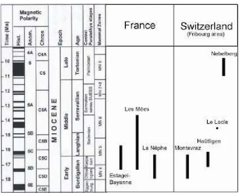
Vegetation change during the Miocene in the Western Alpine area
Moreno, G. J.
Departamento de Estratigrafía y Paleontología, Universidad de Granada, Avda. Fuente Nueva s/n, 18002 Granada (Spain) and Laboratoire PaléoEnvironnements et PaléobioSphčre, UMR CNRS 5125, Université Claude Bernard - Lyon I, 27-43 Boulevard du 11 Novembre, 69622 Villeurbanne (France).
A palynological study has been carried out in several boreholes and sections along the Alpine arc during the Middle and Late Miocene (Fig. 1 & 2). A comparison of the pollen spectra has been done on samples from relatively close areas in France (Istres, Les Mées borehole, La Nčphe) and Switzerland (Haütligen, Montevraz, Le Locle and Nebelberg in the Bern and Fribourg areas). This comparison shows that samples from middle Miocene age are richer in megathermic and mega-mesothermic elements (such as Avicennia (mangrove), Caesalpiniaceae, Melastomataceae, Rubiaceae, Euphorbiaceae, Buxus bahamensis, Acanthaceae, Bombax, Arecaceae, Chloranthaceae, Platycarya, Engelhardia, Sapotaceae, Celastraceae, Taxodiaceae, etc.) than the ones from Tortonian age. The development of the mangrove (rich in Avicennia) in Southern France and Switzerland during the Miocene can be interpreted as corresponding to the Miocene climate optimum comparable to the lowest value of the δ18O in Miller & Feigenson (1991). Therefore, cooler climate conditions are inferred for
the Late Miocene.
Fig. 1. Distribution of the studied sites; 1: Istres area (Estagel & Bayanne sections), 2: Les Mées borehole, 3: La Nèphe section, 4: Bern & Fribourg areas (Montevraz, Haütligen, Le Locle & Nebelberg sections).
Fig. 2. Chronologic distribution of the studied sections and boreholes in the Alpine area.
References:
Miller K.G. and Feigenson M.D. 1991. Miocene isotope reference section, DSDP Site 608: an evaluation of isotope and biostratigraphic resolution. Paleoceanography 6, 1, 33-52.
The Pannonian of the Styrian Basin - State of Knowledge
Groß, M.
Department of Geology & Paleontology, Provincial Museum Joanneum, Raubergasse 10, A-8010 Graz, Austria; [email protected]
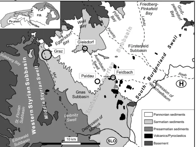
The Styrian Basin is located at the southeastern margin of the Alps. The SW-NE trending South Burgenland Swell separates this basin from the Westpannonian realm. Internally basement spurs and swells divide it into several subbasins (Fig. 1). The basin filling can reach more than 4000 m and reflect trans- and regressions of the Central Paratethys from Ottnangian to Pannonian times and two phases of volcanic activity.
Fig. 1: Geological sketch of the Styrian Basin (S.B. = Styrian Basin, P.B. = Pannonian Basin). Pannonian sediments are restricted to the Eastern Styrian Basin. They cover most of the area but are only a few hundred meters thick. Geological investigations approximately last for 150 years and exploration for hydrocarbon and thermal water reservoirs supplies a huge database. However these information often are unpublished and deal preferably with older rock columns and basin configuration. In recent times the need for correlating aquifers (e.g. public water supply) forced new stratigraphic research activities. >From paleontological and sedimentological point of view our knowledge of the Pannonian sediments is still fragmentary. Biostratigraphic division follows traditionally the “PAPP-Zones”, especially based
on the evolution of “Congeria” and the occurrence of the three toed horse Hipparion. Also other macrovertebrates (MOTTL, 1970) and ostracods (KOLLMANN, 1965) are used for
biostratigraphic investigations. But there are no modern publications on this topic. Recently sequence stratigraphic interpretations are available for central to distal basin areas (KOSI et al.,
After a regression around the Sarmatian/Pannonian boundary, that seems to be related to a major eustatic sea level fall, most of the Eastern Styrian Basin was flooded by the brackish Pannonian Sea. Limnic pelits with rich occurrences of Mytilopsis ornithopsis form the lower part (Eisengraben Member) of the Feldbach Formation. The overlying coarsening upward sand-pelit-alternations indicate development of deltaic environment prograding towards the SE and are termed Sieglegg Member (Fig. 2).
Fig. 2: Lithostratigraphic scheme of the Sarmatian and Pannonian rock column in a NW-SE-section through the Eastern Styrian Basin (M = Münzengraben Bed, M/U = Middle and Upper Pannonian strata; after GROSS, 2003).
Afterwards (Upper Lower Pannonian) alluvial fans in proximal areas pass through the open basin into braided and subsequently into meandering river systems. In central position fluvial Members are closely related to limnic-deltaic environment. Many plant-bearing sites are known from these strata. In the lower part of this Paldau Formation (Münzengraben Bed) an ingression of the Pannonian Sea is proved by paleontological and sequence stratigraphic data. Autocyclic meander and delta lobe switching causes in connection with tectonic processes complex facies pattern. Some examples will demonstrate the lithological and paleontological contents of this Lower Pannonian units. New results of sequence stratigraphic investigations will be discussed.
Middle and Upper Pannonian sediments are known from the vicinity of the South Burgenland Swell. They consist of gravels, sand-pelit-intercalations and thin coal seams. Their bio-, litho-and sequence stratigraphic arrangement remains unclear up to now.
References
Gross, M. (2003): Beitrag zur Lithostratigraphie des Oststeirischen Beckens (Neogen/Pannonium; Österreich). -Österrreichische Akademie der Wissenschaften, Schriftenreihe der Erdwissenschaftlichen Kommissionen,
16: 11-62, 18 Fig., 2 Tab., 1 Map, Wien.
Kollmann, K. (1965): Jungtertiär im Steirischen Becken. - Mitteilungen der Geologischen Gesellschaft in Wien,
57(2): 479-632, 2 Figs., 6 Pl., Wien.
Kosi, W., Sachsenhofer, R.F. & Schreilechner, M. (2003): High Resolution Sequence Stratigraphy of Upper Sarmatian and Lower Pannonian Units in the Styrian Basin, Austria. - Österrreichische Akademie der Wissenschaften, Schriftenreihe der Erdwissenschaftlichen Kommissionen, 16: 63-86, 17 Figs., Wien. Mottl, M. (1970): Die jungtertiären Säugetierfaunen der Steiermark, Südost-Österreichs. - Mitteilung des
Museums für Bergbau, Geologie und Technik am Landesmuseum „Joanneum“ Graz, 31: 3-92, 7 Figs., Graz.
Terrestrial environments and ecosystems during the HRI-2 in the Pannonian
Basin – as interpreted on the basis of flora and vegetation
Hably, L.
Botanical Department of the Hungarian Natural History Museum, 1476 Budapest, Pf. 222. e-mail: [email protected]
Plants are quite suitable for the characterization of the former terrestrial ecosystems and environments. Plants are sensitive in responding to the change of climate and environment, i.e. the floral composition alters which results in the formation of various associations and vegetation types at various habitats.
During the HRI-2 of the Pannonian Basin a leaf-flora with a rather poor diversity can be found at several localities both at the western and eastern part of the basin, e.g. Dozmat, Iharosberény, Balatonszentgyörgy, Tiszapalkonya and sites in Transylvania. This flora is characterized by Glyptostrobus europaeus, Alnus cecropiifolia, Byttneriophyllum tiliifolium. In addition to the dominant taxa above few accessory elements with an extremely low number of specimens are recorded. Based on the ecological requirements of these taxa they must have formed a vegetation in swamp habitats.
Floras of fruits and seeds refer to an aquatic environment, like Trapa praehungarica,
nymphaea szaferi, Nuphar palfalvyi, Ceratophyllum, Lycopus cf. europaeus, Potamogeton sp., Stratiotes tuberculatus, Carex sp. etc. This aquatic vegetation is known from relatively
extensive areas of Visonta and Bükkábrány, from the aquatic, non-swampy areas of the former Pannonian Lake.
During the HRI-2 an additional floral assemblage is also significant in the Pannonian Basin which is characterized by Platanus leucophylla, Liquidambar europaea, Alnus ducalis, Alnus
gaudini and Ulmus, Populus, Salix as accessory elements. These taxa must have existed in
lowlands, in riparian or in gallery forests, thus they represent the remains of the former riparian vegetation. Localities yielding remains of this vegetation are known from Tihany and Győr. Another type of riparian vegetation was found near Sé where almost exclusively the leaf fossils of Salix were recorded.
All the three types of vegetation introduced above are intrazonal and edaphic, thus instead of the zonal climate first of all local edaphic factors, like the water balance and water table of soil, determinate their presence and formation. Since, during the HRI-2 the Pannonian Basin was characterized by these floras all over the basin it may be proper to suppose that there were no extensive terrestrial areas emerging out from the lake where zonal vegetation could have existed. Few traces of this vegetation were recorded only in marginal areas, e.g. Rudabánya, Mataschen, Nauhaus or in „inselbergs” like Aranyosgadány (Mecsek Mts.).
Intrazonal vegetation types are regarded as inadequate indicators of climate. Zonal vegetation types are much more useful from this point of view. Nevertheless, such taxa are recorded in these intrazonal vegetation types on the basis of which a subtropical climate is assumable. Among predominant swamp elements Glyptostrobus and Byttneriophyllum are thermophilous, as well as, Smilax, a subtropical liana occurring in the lowland floras.
In the Pannonian Basin, as it was mentioned above, remains of the zonal vegetation were recorded only in marginal areas and in „inselbergs”. In the nortern marginal areas, like in Rudabánya the occurrence of Daphnogene and Engelhardia proves the existence of thermophilous, subtropical taxa. In the western marginal areas the subtropical flora of Mataschen rich in lauraceous taxa refers to the survival of the subtropical flora in the Pannonian (see J. Eder in this volume).