HAL Id: hal-00296947
https://hal.archives-ouvertes.fr/hal-00296947
Submitted on 3 Mar 2006
HAL is a multi-disciplinary open access archive for the deposit and dissemination of sci-entific research documents, whether they are pub-lished or not. The documents may come from teaching and research institutions in France or abroad, or from public or private research centers.
L’archive ouverte pluridisciplinaire HAL, est destinée au dépôt et à la diffusion de documents scientifiques de niveau recherche, publiés ou non, émanant des établissements d’enseignement et de recherche français ou étrangers, des laboratoires publics ou privés.
The 1997 El Niño impact on clouds, water vapour,
aerosols and reactive trace gases in the troposphere, as
measured by the Global Ozone Monitoring Experiment
D. Loyola, P. Valks, T. Ruppert, A. Richter, T. Wagner, W. Thomas, R. van
der A, R. Meisner
To cite this version:
D. Loyola, P. Valks, T. Ruppert, A. Richter, T. Wagner, et al.. The 1997 El Niño impact on clouds, water vapour, aerosols and reactive trace gases in the troposphere, as measured by the Global Ozone Monitoring Experiment. Advances in Geosciences, European Geosciences Union, 2006, 6, pp.267-272. �hal-00296947�
Advances in Geosciences, 6, 267–272, 2006 SRef-ID: 1680-7359/adgeo/2006-6-267 European Geosciences Union
© 2006 Author(s). This work is licensed under a Creative Commons License.
Advances in
Geosciences
The 1997 El Ni ˜no impact on clouds, water vapour, aerosols and
reactive trace gases in the troposphere, as measured by the Global
Ozone Monitoring Experiment
D. Loyola1, P. Valks1, T. Ruppert2, A. Richter3, T. Wagner4, W. Thomas5, R. van der A6, and R. Meisner2
1German Aerospace Center (DLR), Rem. Sens. Technol. Inst. (IMF), Oberpfaffenhofen, 82334 Wessling, Germany 2German Aerospace Center (DLR), German Rem. Sens. Data Center (DFD), Oberpfaffenhofen, 82334 Wessling, Germany 3University of Bremen, P.O. Box 33 04 40, 28334 Bremen, Germany
4University of Heidelberg, Im Neuenheimer Feld 229, 69120 Heidelberg, Germany 5Deutscher Wetterdienst (DWD), P.O. Box 10 04 65, 63004 Offenbach, Germany
6Royal Netherlands Meteorological Institute (KNMI), P.O.Box 201, 3730 AE De Bilt, The Netherlands Received: 4 May 2005 – Revised: 23 February 2006 – Accepted: 24 February 2006 – Published: 3 March 2006
Abstract. The El Ni˜no event of 1997/1998 caused dry con-ditions over the Indonesian area that were followed by large scale forest and savannah fires over Kalimantan, Sumatra, Java, and parts of Irian Jaya. Biomass burning was most in-tense between August and October 1997, and large amounts of ozone precursors, such as nitrogen oxides, carbon monox-ide and hydrocarbons were emitted into the atmosphere. In this work, we use satellite measurements from the Global Ozone Monitoring Experiment (GOME) sensor to study the teleconnections between the El Ni˜no event of 1997 and the Indonesian fires, clouds, water vapour, aerosols and reactive trace gases (nitrogen dioxide, formaldehyde and ozone) in the troposphere.
1 Introduction
The El Ni˜no event is caused by changes of the normal pat-tern of the circulation over the Pacific Ocean. In normal years there is strong convection of air masses in the West-ern Pacific areas over Indonesia while winds move westward, which causes the balancing flow of relatively warm water at the ocean surface towards Indonesia and Australia. This leads in turn to upwelling cool water masses along the South American coast. In El Ni˜no years we observe the reverse cir-culation pattern which leads to warmer water and elevated sea level along the South American continent. The increased moisture there causes frequent storms and heavy precipita-tion in these areas, enforced by the topographic situaprecipita-tion. On the other hand, abnormal dry conditions occur in the Western
Correspondence to: D. Loyola
(diego.loyola@dlr.de)
Pacific area which often causes a dramatic increase of areas affected by biomass burning.
The intention of the study is to quantify the impact of El Ni˜no events on atmospheric composition and cloud param-eters. For this purpose we used backscatter radiances mea-sured by the Global Ozone Monitoring Experiment (GOME) satellite instrument to describe the relation between the El Ni˜no event of 1997 and changes of a number of atmospheric parameters over the Indonesian area. GOME is a nadir-viewing spectrometer, launched on board the ERS-2 satellite in April 1995, which measures the Earth’s radiance spectrum from UV to near-infrared wavelengths (240–790 nm). The typical footprint size of GOME pixels is about 320×40 km2 allowing global coverage within 3 days (Burrows et al., 1999).
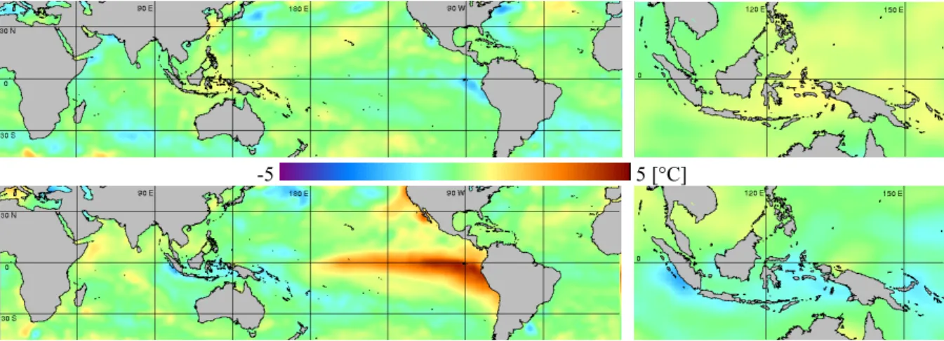
2 Sea surface temperature
Although neither a cloud parameter nor part of the atmo-sphere, we analysed the temporal evolution of the sea surface temperature (SST) to conclude the presence of El Ni˜no con-ditions. We retrieved the sea surface temperature for October 1996 and 1997 by inverting satellite data (NOAA/AVHRR). Figure 1 shows the SST anomaly during the El Ni˜no event of 1997/98 by comparing SST data of October 1996 and Oc-tober 1997. Positive values represent a higher temperature than the zonal average; negative values show lower temper-atures for that specific month. SST anomalies are computed by subtracting the monthly mean data from the climatolog-ical mean for the 1971–2000 base period. This method is appropriate to show relatively warm ocean currents induced by El Ni˜no (lower left panel on Fig. 1) but also relatively cold areas around the Indonesian region (lower right panel on Fig. 1).
268 D. Loyola et al.: El Ni˜no impact on atmospheric constituents
(NOAA/AVHRR). Figure 1 shows the SST anomaly during the El Niño event of 1997/98 by comparing SST data of October 1996 and October 1997. Positive values represent a higher temperature than the zonal average; negative values show lower temperatures for that specific month. SST anomalies are computed by subtracting the monthly mean data from the climatological mean for the 1971-2000 base period. This method is appropriate to show relatively warm ocean currents induced by El Niño (lower left panel on Figure 1) but also relatively cold areas around the Indonesian region (lower right panel on Figure 1).
-5 5 [°C]
Fig. 1. SST anomaly during October 1996 (top) and October 1997 (bottom) calculated using NOAA-AVHRR data provided by NASA’s JPL
3 Fires and Aerosols
The usual rainfall surrounding Indonesia is abated during El Niño events due to changes of the atmospheric circulation. The dry conditions over the Indonesian area finally result in large scale biomass burning, especially in Kalimantan and Sumatra. Biomass burning events may be observed in a number of ways from space. Satellite sensors with high spatial resolution and a limited number of spectral channels such as the AVHRR sensor or its European counterparts (the series of ATSR instruments) can provide detailed visual information of the spatial distribution of smoke clouds and fires. Figure 2a shows the fires registered by ATSR-2 during October 1997. Highly-absorbing aerosols associated with biomass burning have been detected using the TOMS (Hsu et al., 1994) and GOME instruments (De Graaf et al., 2005). Figure 2b shows the monthly averaged aerosol index over the Indonesian area as measured by GOME during October 1997.
(a) (b)
Fig. 2. (a) ATSR-2 fire count in red during October 1997 provided by ESA’s world fire atlas. (b) GOME aerosol
index (from -3 to 3) during October 1997.
The absorbing aerosol index is clearly higher in the Southern parts of Borneo, over Indonesia and Papua New Guinea where ATSR-2 data indicate a large number of fire spots on the ground. Fires at the Australian continent obviously produced lower aerosol masses which may be explained by the sparser vegetation that is mainly savannah.
4 Cloud Fraction, Cloud-top Pressure and Cloud Optical Thickness
Various cloud parameters can be measured with the GOME instrument. Cloud fraction is determined using broadband radiance measurements in the UV/VIS range, whilst cloud-top
Fig. 1. SST anomaly during October 1996 (top) and October 1997 (bottom) calculated using NOAA-AVHRR data provided by NASA’s JPL.
(NOAA/AVHRR). Figure 1 shows the SST anomaly during the El Niño event of 1997/98 by
comparing SST data of October 1996 and October 1997. Positive values represent a higher
temperature than the zonal average; negative values show lower temperatures for that specific
month. SST anomalies are computed by subtracting the monthly mean data from the
climatological mean for the 1971-2000 base period. This method is appropriate to show
relatively warm ocean currents induced by El Niño (lower left panel on Figure 1) but also
relatively cold areas around the Indonesian region (lower right panel on Figure 1).
-5 5 [°C]
Fig. 1. SST anomaly during October 1996 (top) and October 1997 (bottom) calculated using
NOAA-AVHRR data provided by NASA’s JPL
3 Fires and Aerosols
The usual rainfall surrounding Indonesia is abated during El Niño events due to changes of the
atmospheric circulation. The dry conditions over the Indonesian area finally result in large scale
biomass burning, especially in Kalimantan and Sumatra. Biomass burning events may be
observed in a number of ways from space. Satellite sensors with high spatial resolution and a
limited number of spectral channels such as the AVHRR sensor or its European counterparts (the
series of ATSR instruments) can provide detailed visual information of the spatial distribution of
smoke clouds and fires. Figure 2a shows the fires registered by ATSR-2 during October 1997.
Highly-absorbing aerosols associated with biomass burning have been detected using the TOMS
(Hsu et al., 1994) and GOME instruments (De Graaf et al., 2005). Figure 2b shows the monthly
averaged aerosol index over the Indonesian area as measured by GOME during October 1997.
(a) (b)
Fig. 2. (a) ATSR-2 fire count in red during October 1997 provided by ESA’s world fire atlas. (b) GOME aerosol
index (from -3 to 3) during October 1997.
The absorbing aerosol index is clearly higher in the Southern parts of Borneo, over Indonesia
and Papua New Guinea where ATSR-2 data indicate a large number of fire spots on the ground.
Fires at the Australian continent obviously produced lower aerosol masses which may be
explained by the sparser vegetation that is mainly savannah.
4 Cloud Fraction, Cloud-top Pressure and Cloud Optical Thickness
Various cloud parameters can be measured with the GOME instrument. Cloud fraction is
determined using broadband radiance measurements in the UV/VIS range, whilst cloud-top
Fig. 2. (a) ATSR-2 fire count in red during October 1997 provided by ESA’s world fire atlas. (b) GOME aerosol index (from −3 to 3) during
October 1997.
3 Fires and aerosols
The usual rainfall surrounding Indonesia is abated during El Ni˜no events due to changes of the atmospheric circulation. The dry conditions over the Indonesian area finally result in large scale biomass burning, especially in Kalimantan and Sumatra. Biomass burning events may be observed in a num-ber of ways from space. Satellite sensors with high spatial resolution and a limited number of spectral channels such as the AVHRR sensor or its European counterparts (the series of ATSR instruments) can provide detailed visual information of the spatial distribution of smoke clouds and fires. Fig-ure 2a shows the fires registered by ATSR-2 during October 1997. Highly-absorbing aerosols associated with biomass burning have been detected using the TOMS (Hsu et al., 1994) and GOME instruments (De Graaf et al., 2005). Fig-ure 2b shows the monthly averaged aerosol index over the In-donesian area as measured by GOME during October 1997.
The absorbing aerosol index is clearly higher in the South-ern parts of Borneo, over Indonesia and Papua New Guinea where ATSR-2 data indicate a large number of fire spots on the ground. Fires at the Australian continent obviously pro-duced lower aerosol masses which may be explained by the sparser vegetation that is mainly savannah.
4 Cloud fraction, cloud-top pressure and cloud optical thickness
Various cloud parameters can be measured with the GOME instrument. Cloud fraction is determined using broadband radiance measurements in the UV/VIS range, whilst cloud-top pressure (cloud-cloud-top height) and cloud optical thickness (cloud-top albedo) are retrieved from the spectral informa-tion in the Oxygen A-band in and around 760 nm (Loyola, 2004). Figure 3 illustrates the effect of the 1997–1998 El Ni˜no on the cloud distribution over the tropics. October 1997 shows a high cloud fraction anomaly over the equatorial cen-tral Pacific area with a simultaneous decrease of the cloud-top pressure and the cloud optical thickness (Fig. 4).
Notice the low cloud fraction anomaly over large parts of the Indonesian region as a consequence of the dry conditions. The apparent cloud increase over Kalimantan and Sumatra is induced by smoke clouds (see Fig. 2b).
The cloud optical thickness anomaly indicates that the ar-eas with an apparent cloud incrar-ease are populated with rel-atively thin clouds; this feature is clearly visible over Kali-mantan and Sumatra (see Figs. 3 and 4).
D. Loyola et al.: El Ni˜no impact on atmospheric constituents 269
pressure (cloud-top height) and cloud optical thickness (cloud-top albedo) are retrieved from the spectral information in the Oxygen A-band in and around 760nm (Loyola, 2004). Figure 3 illustrates the effect of the 1997-1998 El Niño on the cloud distribution over the tropics. October 1997 shows a high cloud fraction anomaly over the equatorial central Pacific area with a simultaneous decrease of the cloud-top pressure and the cloud optical thickness (Figure 4).
-0.5 0.5 [-]
Fig. 3. Cloud fraction anomaly during October 1996 (top) and October 1997 (bottom)
Notice the low cloud fraction anomaly over large parts of the Indonesian region as a consequence of the dry conditions. The apparent cloud increase over Kalimantan and Sumatra is induced by smoke clouds (see Figure 2b).
-10 350 [-]
Fig. 4. Cloud optical thickness anomaly during October 1996 (top) and October 1997 (bottom)
The cloud optical thickness anomaly indicates that the areas with an apparent cloud increase are populated with relatively thin clouds; this feature is clearly visible over Kalimantan and Sumatra (see Figures 3 and 4).
5 Water Vapour Column
Global water vapour column distributions have been measured with the GOME instrument, using the visible wavelength region with the DOAS technique (Wagner et al., 2005). In contrast to other satellite observations of water vapour, the GOME observations are of similar sensitivity over both land and ocean.
Fig. 3. Cloud fraction anomaly during October 1996 (top) and October 1997 (bottom).
pressure (cloud-top height) and cloud optical thickness (cloud-top albedo) are retrieved from the spectral information in the Oxygen A-band in and around 760nm (Loyola, 2004). Figure 3 illustrates the effect of the 1997-1998 El Niño on the cloud distribution over the tropics. October 1997 shows a high cloud fraction anomaly over the equatorial central Pacific area with a simultaneous decrease of the cloud-top pressure and the cloud optical thickness (Figure 4).
-0.5 0.5 [-]
Fig. 3. Cloud fraction anomaly during October 1996 (top) and October 1997 (bottom)
Notice the low cloud fraction anomaly over large parts of the Indonesian region as a consequence of the dry conditions. The apparent cloud increase over Kalimantan and Sumatra is induced by smoke clouds (see Figure 2b).
-10 350 [-]
Fig. 4. Cloud optical thickness anomaly during October 1996 (top) and October 1997 (bottom)
The cloud optical thickness anomaly indicates that the areas with an apparent cloud increase are populated with relatively thin clouds; this feature is clearly visible over Kalimantan and Sumatra (see Figures 3 and 4).
5 Water Vapour Column
Global water vapour column distributions have been measured with the GOME instrument, using the visible wavelength region with the DOAS technique (Wagner et al., 2005). In contrast to other satellite observations of water vapour, the GOME observations are of similar sensitivity over both land and ocean.
Fig. 4. Cloud optical thickness anomaly during October 1996 (top) and October 1997 (bottom).
5 Water vapour column
Global water vapour column distributions have been mea-sured with the GOME instrument, using the visible wave-length region with the DOAS technique (Wagner et al., 2005). In contrast to other satellite observations of water vapour, the GOME observations are of similar sensitivity over both land and ocean.
Figure 5 illustrates the effect of the 1997/1998 El Ni˜no on the global distribution of the water vapour abundance in the atmosphere. The relative anomalies are averaged from Octo-ber 1997 to March 1998 (bottom) and for the same period of the previous year (top). Relatively small water vapour anomalies are found over the Indonesian region, indicating the dry conditions over this area. Note also the correspond-ing high water vapour anomaly over the equatorial Eastern Pacific during the El Ni˜no period that clearly follows the SST anomaly in this region (Fig. 1).
As expected, there is a clear correlation between the GOME measurements of water vapour (Fig. 5) and the cloud parameters (Figs. 3 and 4).
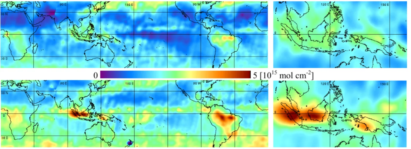
6 Tropospheric NO2column
Nitrogen dioxide (NO2)is generated in natural (soil, light-ning) and man-made (industrial production and heating, au-tomobile combustion, biomass burning) processes. In clear air masses the bulk of NO2is in the stratosphere while large amounts of NO2are found in the lower troposphere, if pol-luted air masses over industrial regions or biomass burning areas are analyzed.
The essential step in the retrieval of the tropospheric NO2 amount from GOME measurements is the separation of stratospheric and tropospheric contributions to the signal. Measurements over a clean air area (the Pacific) are used to estimate the stratospheric NO2 column and differences be-tween local column measurements and the clean air mea-surement are used to derive the tropospheric NO2 column. For the data used here, this method has been refined by using the three dimensional chemical transport model SLIMCAT to account for the longitudinal variations of stratospheric NO2 (Richter et al., 2005). Figure 6 shows GOME tropo-spheric NO2anomaly during September 1996 and 1997. The large scale biomass burning over Kalimantan and Sumatra
270 D. Loyola et al.: El Ni˜no impact on atmospheric constituents
-0.6 0.6 [-]
Fig. 5. Relative water vapour anomaly during 1996/1997 (top) and 1997/1998 (bottom). The anomalies are
calculated with respect to the average of the non El Niño years (1996/1997, 1998/1999, 1999/2000, 2000/2001) Figure 5 illustrates the effect of the 1997/1998 El Niño on the global distribution of the water vapour abundance in the atmosphere. The relative anomalies are averaged from October 1997 to March 1998 (bottom) and for the same period of the previous year (top). Relatively small water vapour anomalies are found over the Indonesian region, indicating the dry conditions over this area. Note also the corresponding high water vapour anomaly over the equatorial Eastern Pacific during the El Niño period that clearly follows the SST anomaly in this region (Figure 1).
As expected, there is a clear correlation between the GOME measurements of water vapour (Figure 5) and the cloud parameters (Figures 3 and 4).
6 Tropospheric NO2 Column
Nitrogen dioxide (NO2) is generated in natural (soil, lightning) and man-made (industrial
production and heating, automobile combustion, biomass burning) processes. In clear air masses the bulk of NO2 is in the stratosphere while large amounts of NO2 are found in the lower
troposphere, if polluted air masses over industrial regions or biomass burning areas are analyzed. The essential step in the retrieval of the tropospheric NO2 amount from GOME measurements is
the separation of stratospheric and tropospheric contributions to the signal. Measurements over a clean air area (the Pacific) are used to estimate the stratospheric NO2 column and differences
between local column measurements and the clean air measurement are used to derive the tropospheric NO2 column. For the data used here, this method has been refined by using the three
dimensional chemical transport model SLIMCAT to account for the longitudinal variations of stratospheric NO2 (Richter et al., 2005). Figure 6 shows GOME tropospheric NO2 anomaly
during September 1996 and 1997. The large scale biomass burning over Kalimantan and Sumatra in September 1997 resulted in highly elevated NO2 columns over Indonesia, as can be
seen in the bottom picture. Tropospheric NO2 columns of 1·1015 - 3·1015 mol cm-2 are measured
over Kalimantan in September 1997, while typical values of 2·1014 mol cm-2 and below are found over the same area in 1996.
-5 15 [1014 mol cm-2]
Fig. 5. Relative water vapour anomaly during 1996/1997 (top) and 1997/1998 (bottom). The anomalies are calculated with respect to the
average of the non El Ni˜no years (1996/1997, 1998/1999, 1999/2000, 2000/2001).
-0.6 0.6 [-]
Fig. 5. Relative water vapour anomaly during 1996/1997 (top) and 1997/1998 (bottom). The anomalies are
calculated with respect to the average of the non El Niño years (1996/1997, 1998/1999, 1999/2000, 2000/2001) Figure 5 illustrates the effect of the 1997/1998 El Niño on the global distribution of the water vapour abundance in the atmosphere. The relative anomalies are averaged from October 1997 to March 1998 (bottom) and for the same period of the previous year (top). Relatively small water vapour anomalies are found over the Indonesian region, indicating the dry conditions over this area. Note also the corresponding high water vapour anomaly over the equatorial Eastern Pacific during the El Niño period that clearly follows the SST anomaly in this region (Figure 1).
As expected, there is a clear correlation between the GOME measurements of water vapour (Figure 5) and the cloud parameters (Figures 3 and 4).
6 Tropospheric NO2 Column
Nitrogen dioxide (NO2) is generated in natural (soil, lightning) and man-made (industrial
production and heating, automobile combustion, biomass burning) processes. In clear air masses the bulk of NO2 is in the stratosphere while large amounts of NO2 are found in the lower
troposphere, if polluted air masses over industrial regions or biomass burning areas are analyzed. The essential step in the retrieval of the tropospheric NO2 amount from GOME measurements is
the separation of stratospheric and tropospheric contributions to the signal. Measurements over a clean air area (the Pacific) are used to estimate the stratospheric NO2 column and differences
between local column measurements and the clean air measurement are used to derive the tropospheric NO2 column. For the data used here, this method has been refined by using the three
dimensional chemical transport model SLIMCAT to account for the longitudinal variations of stratospheric NO2 (Richter et al., 2005). Figure 6 shows GOME tropospheric NO2 anomaly
during September 1996 and 1997. The large scale biomass burning over Kalimantan and Sumatra in September 1997 resulted in highly elevated NO2 columns over Indonesia, as can be
seen in the bottom picture. Tropospheric NO2 columns of 1·1015 - 3·1015 mol cm-2 are measured
over Kalimantan in September 1997, while typical values of 2·1014 mol cm-2 and below are found over the same area in 1996.
-5 15 [1014 mol cm-2]
Fig. 6. Tropospheric NO2 anomaly during September 1996 (top) and September 1997 (bottom) 7 Formaldehyde Column
Formaldehyde (H2CO) is generated directly in burning processes but also by subsequent
oxidation of hydrocarbons. The building process is more effective under lower temperatures e.g., in smouldering fires. In a biomass burning scenario, formaldehyde levels are expected to be large in the troposphere, where hydrocarbon oxidation is greatly enhanced; in undisturbed atmospheres H2CO is a product of the methane cycle. Formaldehyde retrieval from GOME
backscatter data in the UV wavelength region was first shown by Thomas et al. (1998).
Figure 7 shows the GOME tropospheric formaldehyde columns during October 1996 and 1997. Clearly visible are the strongly elevated formaldehyde abundance over the Indonesian region in October 1997 as a result of the large emissions of hydrocarbons during the biomass burnings.
0 5 [1015 mol cm-2]
Fig. 7. Formaldehyde column during October 1996 (top) and October 1997 (bottom) 8 Tropospheric Ozone Column
The tropospheric ozone column in the tropics has been determined from GOME ozone column and cloud measurements, using the so-called convective-cloud-differential (CCD) method (Valks et al., 2003). Figure 8 shows the tropospheric ozone column over the tropical region during October 1996 and 1997. Ozone is produced by photochemical reactions of nitrogen oxides, carbon monoxide, methane and other hydrocarbons, which are released in large amounts by tropical biomass burnings.
The elevated tropospheric ozone columns over the tropical Atlantic and Africa in October 1996 are a result of the normal burning season in southern Africa and Brazil. The effect of the forest and savannah fires over Kalimantan and Sumatra in 1997 is clearly visible in the bottom picture. In October 1997 high tropospheric ozone columns are found over the Indonesian region and a plume of elevated ozone values extends over a large region of the Indian Ocean, west of Indonesia.
During the El Niño period, ozone is concentrated in the free troposphere (mainly between 3 to 6 km) above the fire areas, and transported from the source regions to the Indian Ocean with the prevailing easterlies (Thompson et al., 2001; Chandra et al., 2002).
Fig. 6. Tropospheric NO2anomaly during September 1996 (top) and September 1997 (bottom).
in September 1997 resulted in highly elevated NO2columns over Indonesia, as can be seen in the bottom picture. Tropo-spheric NO2columns of 1×10¹⁵–3×10¹⁵mol cm−2are mea-sured over Kalimantan in September 1997, while typical val-ues of 2×10¹⁴mol cm−2and below are found over the same area in 1996.
7 Formaldehyde column
Formaldehyde (H2CO) is generated directly in burning pro-cesses but also by subsequent oxidation of hydrocarbons. The building process is more effective under lower tem-peratures e.g., in smouldering fires. In a biomass burn-ing scenario, formaldehyde levels are expected to be large in the troposphere, where hydrocarbon oxidation is greatly enhanced; in undisturbed atmospheres H2CO is a product of the methane cycle. Formaldehyde retrieval from GOME backscatter data in the UV wavelength region was first shown by Thomas et al. (1998).
Figure 7 shows the GOME tropospheric formaldehyde columns during October 1996 and 1997. Clearly visible are the strongly elevated formaldehyde abundance over the In-donesian region in October 1997 as a result of the large emis-sions of hydrocarbons during the biomass burnings.
8 Tropospheric ozone column
The tropospheric ozone column in the tropics has been determined from GOME ozone column and cloud mea-surements, using the so-called convective-cloud-differential (CCD) method (Valks et al., 2003). Figure 8 shows the tro-pospheric ozone column over the tropical region during Oc-tober 1996 and 1997. Ozone is produced by photochemical reactions of nitrogen oxides, carbon monoxide, methane and other hydrocarbons, which are released in large amounts by tropical biomass burnings.
The elevated tropospheric ozone columns over the tropical Atlantic and Africa in October 1996 are a result of the normal
D. Loyola et al.: El Ni˜no impact on atmospheric constituents 271
Fig. 6. Tropospheric NO2 anomaly during September 1996 (top) and September 1997 (bottom) 7 Formaldehyde Column
Formaldehyde (H2CO) is generated directly in burning processes but also by subsequent
oxidation of hydrocarbons. The building process is more effective under lower temperatures e.g., in smouldering fires. In a biomass burning scenario, formaldehyde levels are expected to be large in the troposphere, where hydrocarbon oxidation is greatly enhanced; in undisturbed atmospheres H2CO is a product of the methane cycle. Formaldehyde retrieval from GOME
backscatter data in the UV wavelength region was first shown by Thomas et al. (1998).
Figure 7 shows the GOME tropospheric formaldehyde columns during October 1996 and 1997. Clearly visible are the strongly elevated formaldehyde abundance over the Indonesian region in October 1997 as a result of the large emissions of hydrocarbons during the biomass burnings.
0 5 [1015 mol cm-2]
Fig. 7. Formaldehyde column during October 1996 (top) and October 1997 (bottom) 8 Tropospheric Ozone Column
The tropospheric ozone column in the tropics has been determined from GOME ozone column and cloud measurements, using the so-called convective-cloud-differential (CCD) method (Valks et al., 2003). Figure 8 shows the tropospheric ozone column over the tropical region during October 1996 and 1997. Ozone is produced by photochemical reactions of nitrogen oxides, carbon monoxide, methane and other hydrocarbons, which are released in large amounts by tropical biomass burnings.
The elevated tropospheric ozone columns over the tropical Atlantic and Africa in October 1996 are a result of the normal burning season in southern Africa and Brazil. The effect of the forest and savannah fires over Kalimantan and Sumatra in 1997 is clearly visible in the bottom picture. In October 1997 high tropospheric ozone columns are found over the Indonesian region and a plume of elevated ozone values extends over a large region of the Indian Ocean, west of Indonesia.
During the El Niño period, ozone is concentrated in the free troposphere (mainly between 3 to 6 km) above the fire areas, and transported from the source regions to the Indian Ocean with the prevailing easterlies (Thompson et al., 2001; Chandra et al., 2002).
Fig. 7. Formaldehyde column during October 1996 (top) and October 1997 (bottom).
10 45 [DU]
Fig. 8. Tropospheric Ozone column during October 1996 (top) and October 1997 (bottom) 9 Discussion and Conclusions
We have shown the relation between the El Niño event of 1997 and the observed Indonesian fires, changes in cloud parameters, and the atmospheric composition in the troposphere (water vapour, aerosols and reactive trace gases such as nitrogen dioxide, formaldehyde and ozone) using GOME satellite measurements.
Changes of the sea surface temperature, cloudiness and water vapour, the latter two quantities derived from GOME data, clearly indicated the presence of an El Niño event in autumn 1997. Sea surface temperature increased along the South American coastline in equatorial regions while the cloudiness was low over South East Asia and cloud-top pressure increased. Abnormally dry conditions over South-East Asia were clearly visible in the decreased atmospheric water vapour content as retrieved from GOME data. This caused finally heavy biomass burning in large regions of Indonesia, Kalimantan and Java, partly because the traditional slash-and-burn farming method went out of control. The fires are responsible for a strong increase of soot and dust-like aerosols with high absorption capabilities. A second effect of the fires is the enhancement of chemically active species in the troposphere, which originate either directly from burning processes (nitrogen dioxide, formaldehyde, carbon monoxide) or stem from photochemical reactions (ozone).
We could show that especially tropospheric nitrogen dioxide and formaldehyde levels largely increased by a factor of 10 over the areas where fires were located. Similarly the tropospheric ozone content increased by a factor of 3. As result of the large emissions combined with rapid transport, even the short lived species (NO2, H2CO) affected a large area and ozone was
enhanced all the way to Africa.
The anomalies presented are a good example for dramatic changes of the environment that are initially caused by a change of the atmospheric circulation pattern and its subsequent impact on the ocean state.
Acknowledgments
The authors gratefully thank the reviewers for detailed comments; the paper has benefited significantly as a result. ESA is acknowledged for facilitating the access to ATSR-2 and GOME data, as well as NASA for the SST data. Part or this work was supported by the European Union through the ACCENT project.
References
Burrows J:P., M. Weber, M. Buchwitz, V. Rozanov, A. Ladstaetter-Weissenmayer , A. Richter, R. de Beek, R. Hoogen, K. Bramstedt, K.-U. Eichmann, M. Eisinger, and D. Perner, The Global Ozone Monitoring Experiment (GOME): Mission concept and first scientific results,
J. Atm. Sci., 56, 151-175, 1999.
Fig. 8. Tropospheric Ozone column during October 1996 (top) and October 1997 (bottom).
burning season in southern Africa and Brazil. The effect of the forest and savannah fires over Kalimantan and Sumatra in 1997 is clearly visible in the bottom picture. In October 1997 high tropospheric ozone columns are found over the Indone-sian region and a plume of elevated ozone values extends over a large region of the Indian Ocean, west of Indonesia.
During the El Ni˜no period, ozone is concentrated in the free troposphere (mainly between 3 to 6 km) above the fire areas, and transported from the source regions to the Indian Ocean with the prevailing easterlies (Thompson et al., 2001; Chandra et al., 2002).
9 Discussion and conclusions
We have shown the relation between the El Ni˜no event of 1997 and the observed Indonesian fires, changes in cloud parameters, and the atmospheric composition in the tropo-sphere (water vapour, aerosols and reactive trace gases such as nitrogen dioxide, formaldehyde and ozone) using GOME satellite measurements.
Changes of the sea surface temperature, cloudiness and water vapour, the latter two quantities derived from GOME data, clearly indicated the presence of an El Ni˜no event in autumn 1997. Sea surface temperature increased along the South American coastline in equatorial regions while the cloudiness was low over South East Asia and cloud-top pres-sure increased. Abnormally dry conditions over South-East Asia were clearly visible in the decreased atmospheric water vapour content as retrieved from GOME data. This caused finally heavy biomass burning in large regions of Indonesia, Kalimantan and Java, partly because the traditional slash-and-burn farming method went out of control. The fires are responsible for a strong increase of soot and dust-like aerosols with high absorption capabilities. A second effect of the fires is the enhancement of chemically active species in the troposphere, which originate either directly from burning processes (nitrogen dioxide, formaldehyde, carbon monox-ide) or stem from photochemical reactions (ozone).
We could show that especially tropospheric nitrogen diox-ide and formaldehyde levels largely increased by a factor of 10 over the areas where fires were located. Similarly the
272 D. Loyola et al.: El Ni˜no impact on atmospheric constituents tropospheric ozone content increased by a factor of 3. As
result of the large emissions combined with rapid transport, even the short lived species (NO2, H2CO) affected a large area and ozone was enhanced all the way to Africa.
The anomalies presented are a good example for dramatic changes of the environment that are initially caused by a change of the atmospheric circulation pattern and its subse-quent impact on the ocean state.
Acknowledgements. The authors gratefully thank the reviewers
for detailed comments; the paper has benefited significantly as a result. ESA is acknowledged for facilitating the access to ATSR-2 and GOME data, as well as NASA for the SST data. Part or this work was supported by the European Union through the ACCENT project.
Edited by: P. Fabian and J. L. Santos
Reviewed by: H. Dijkstra and another anonymous referee
References
Burrows, J. P., Weber, M., Buchwitz, M., Rozanov, V., Ladstaetter-Weissenmayer, A., Richter, A., de Beek, R., Hoogen, R., Bram-stedt, K., Eichmann, K.-U., Eisinger, M., and Perner, D.: The Global Ozone Monitoring Experiment (GOME): Mission con-cept and first scientific results, J. Atm. Sci., 56, 151–175, 1999. Chandra, S., Ziemke, J. R., Bhartia, P. K., and Martin, R. V.:
Tropical tropospheric ozone: Implications for dynamics and biomass burning, J. Geophys. Res., 107, 4188, doi:10.1029 /2001JD000447, 2002.
De Graaf, M., Stammes, P., Torres, O., and Koelemeijer, R. B. A.: Absorbing Aerosol Index: Sensitivity analysis, application to GOME and comparison with TOMS, J. Geophys. Res., 110, D01201, doi:10.1029/2004JD005178, 2004.
Hsu, N. C., Herman, J. R., Bhartia, P. K., Seftor, C. J., Torres, O., Thompson, A. M., Gleason, J. F., Eck, T. F., and Holben, B. N.: Detection of Biomass Burning Smoke from TOMS measure-ments, Geophys. Res. Lett., 23, 745–748, 1994.
Loyola, D.: Automatic Cloud Analysis from Polar-Orbiting Satel-lites using Neural Network and Data Fusion Techniques, IEEE International Geoscience and Remote Sensing Symposium, 4, 2530–2534, 2004.
Richter, A., Burrows, J. P., N¨uß, H., Granier, C., and Niemeier, U.: Increase in tropospheric nitrogen dioxide over China observed from space, Nature, 437, 129–132, doi:10.1038/nature04092, 2005.
Thomas, W., Hegels, E., Slijkhuis, S., Spurr, R., and Chance, K.: Detection of biomass burning combustion products in Southeast Asia from backscatter data taken by the GOME spectrometer, Geophys. Res. Lett., 25, 1317–1320, 1998.
Thompson, A. M., Witte, J. C., Hudson, R. D., Guo, H., Herman, J. R., and Fujiwara, M.: Tropical tropospheric ozone and biomass burning, Science, 291, 2128–2132, 2001.
Valks, P. J. M., Koelemeijer, R. B. A., van Weele, M., van Velthoven, P., Fortuin, J. P. F., and Kelder, H.: Variability in trop-ical tropospheric ozone: Analysis with Global Ozone Monitoring Experiment observations and a global model, J. Geophys. Res., 108, 4328, doi:10.1029 /2002JD002894, 2003.
Wagner, T., Beirle, S., Grzegorski, M., Sanghavi, S., and Platt, U.: El-Ni˜no induced anomalies in global data sets of total column precipitable water and cloud cover derived from GOME on ERS-2, J. Geophys. Res., 110, D15104, doi:10.1029/2005JD00597ERS-2, 2005.