Computer Science and Artificial Intelligence Laboratory
Technical Report
MIT-CSAIL-TR-2018-003
January 29, 2018
Decision Uncertainty Minimization and
Autonomous Information Gathering
Decision Uncertainty Minimization
and
Autonomous Information Gathering
by
Lawrence A. M. Bush
Submitted to the Department of Aeronautics and Astronautics
in partial fulfillment of the requirements for the degree of
Doctor of Philosophy
at the
MASSACHUSETTS INSTITUTE OF TECHNOLOGY
September 2013
c
Massachusetts Institute of Technology 2013. All rights reserved.
Author . . . .
Department of Aeronautics and Astronautics
August 22, 2013
Certified by . . . .
Brian Williams
Professor of Aeronautics and Astronautics
Massachusetts Institute of Technology
Thesis Supervisor
Certified by . . . .
Sridhar Mahadevan
Professor in Computer Science
University of Massachusetts, Amherst
Certified by . . . .
Pierre Lermusiaux
Doherty Associate Professor in Ocean Utilization
Massachusetts Institute of Technology
Accepted by. . . .
Eytan H. Modiano
Associate Professor of Aeronautics and Astronautics
Chair, Committee on Graduate Students
Decision Uncertainty Minimization
and
Autonomous Information Gathering
by
Lawrence A. M. Bush
Submitted to the Department of Aeronautics and Astronautics on August 22, 2013, in partial fulfillment of the
requirements for the degree of Doctor of Philosophy
Abstract
Over the past several decades, technologies for remote sensing and exploration have be-come increasingly powerful but continue to face limitations in the areas of information gathering and analysis. These limitations affect technologies that use autonomous agents, which are devices that can make routine decisions independent of operator instructions. Bandwidth and other communications limitation require that autonomous differentiate be-tween relevant and irrelevant information in a computationally efficient manner.
This thesis presents a novel approach to this problem by framing it as an adaptive sensing problem. Adaptive sensing allows agents to modify their information collection strategies in response to the information gathered in real time. We developed and tested optimization algorithms that apply information guides to Monte Carlo planners. Informa-tion guides provide a mechanism by which the algorithms may blend online (realtime) and offline (previously simulated) planning in order to incorporate uncertainty into the decision-making process. This greatly reduces computational operations as well as decisional and communications overhead.
We begin by introducing a 3-level hierarchy that visualizes adaptive sensing at synop-tic (global), mesocale (intermediate) and microscale (close-up) levels (a spatial hierarchy). We then introduce new algorithms for decision uncertainty minimization (DUM) and rep-resentational uncertainty minimization (RUM). Finally, we demonstrate the utility of this approach to real-world sensing problems, including bathymetric mapping and disaster re-lief. We also examine its potential in space exploration tasks by describing its use in a hypothetical aerial exploration of Mars. Our ultimate goal is to facilitate future large-scale missions to extraterrestrial objects for the purposes of scientific advancement and human exploration.
Brian Williams
Title: Professor of Aeronautics and Astronautics Massachusetts Institute of Technology
Acknowledgments
Graduate research never occurs in a vacuum. I would like to express my deep gratitude to members of both my professional and personal community who supported me during the completion of this thesis. My foremost supporter in the professional realm was my advisor Brian Williams who has offered encouragement, guidance and many other forms of support. Brian facilitated my collaborations with researchers at MBARI and the NASA Ames Research Center and has played an active role in my career development, especially in the areas of grant writing and funding acquisition. The amount of time Brian contributed to developing the concepts in this thesis, improving my writing skills and telling me funny stories is a debt that I hope I will have the opportunity to repay in future collaborative ef-forts. My minor advisor Patrick Winston has always supported and inspired me, especially during coursework with him, in which I learned oral and written presentation skills. Com-mittee members Sridhar Mahadavan and Pierre Lermusiaux provided encouragement and helpful advice through all stages of my research.
I am also grateful to Richard Lippmann and Sai Ravela for their service as thesis read-ers. Early in my career, through his course Rich provided me with an unbelievably thorough background in pattern recognition. I was also inspired by his enthusiasm and the generos-ity with which he gave his attention to my research efforts. Sai Ravela taught me about uncertainty quantification and provided invaluable discussions on the subject as a reader. Sai’s good nature and intelligence has also offered me a great example of collegiality at its best.
I have also enjoyed collegial relations with my fellow students including Alborz Geram-ifard, Tony Jimenez, Andrew Wang, Eric Timmons, James Patterson, James McGrew and Lars Blackmore. My peers Pedro Santana, Shawn Kraut and Ben Landon have contributed by reading and offering feedback on this thesis. Julie Shah provided perspective, moral support and strategy throughout my graduate career. I am grateful to Robert Morris for hosting me at the NASA-Ames Research Institute and to Nico Mealeau for his mentorship there at Moffett Field. Our interactions inspired my interest in active sensing, space ap-plications and reinforcement learning. Kanna Rajan collaborated with and hosted me at
MBARI (the Monterey Bay Aquarium Research Institute) where I also had the privilege of working with David Caress in field testing my algorithm on their autonomous underwater vehicle. I also wish to acknowledge my former boss, Joe Chapa for always recognizing the forward looking and innovative aspects of my work. I was also inspired by his unwavering willingness to stand up for his employees. I also fondly recall Douglas Marquis, another former boss, who encouraged me to “go put a Dr. in front of [my] name.”
I am deeply grateful to the Lincoln Scholars program and Ken Estebrooke for finan-cially supporting the greater part of my Ph.D. career. 1 I will always appreciate Bob Shin and Lou Bellaire for continuing to have faith in me and support me to the end of my PhD. Karen Wilcox and Brian Williams also helped me identify sources of financial support. Bernadette Johnson and Andy Vidan who supported me in numerous ways, especially dur-ing some uphill sections of my journey. Sara Peterson, our group’s administrative assistant has been generous and diligent in helping me put out fires and find my way around the Institute. My graduate studies have also provided me with a number of enriching oppor-tunities, not directly related to uncertainty minimization. Over the past 3 years I have mentored 6 RSI (Research Science Institute) students: Changlin Ke, Lukas Missik, Albert Chu, Maxwell Wang, Jon Xia and Fredric Moezinia. These exceptional 12th graders each came to MIT for 6-weeks of a summer during which I had the privilege of sharing my re-search with them. They were always elated by the opportunity, and fanatical in their efforts. Their zeal carried me through some of the less inspiring parts of my research.
My brother Chris has happily answered many statistics questions for me and supported me like only a brother can. Finally I am most grateful to my loving and supportive wife, Nancy, and our three wonderful children who are a deep inspiration to me, and are the real secret of my success.
1This work is sponsored by the Department of Air Force under Air Force Contract #FA8721-05-C-0002.
Opinions, interpretations, conclusions, and recommendations are those of the author and are not necessarily endorsed by the United States Government
1 Forward
This thesis addresses the integration of data collection and processing needs of orbital and airborne missions. The motivating purpose is to develop a consistent strategy for ex-ploration in support of long-term human missions to terrestrial planets. The thesis specifi-cally addresses the informational requirements for large-scale adaptive sensing missions on Earth and Mars. This research addresses several remote adaptive sensing concepts through ocean sensing, disaster response and Mars exploration applications. Using these tasks as a framework, the thesis lays out a quantitative model for how to make decisions to gather information intelligently and dynamically. The primary objective of this thesis is to intro-duce algorithms that improve the quality of automated decisions made in real time and to incorporate uncertainty terms into informational value estimates used in remote sensing. The thesis makes a critical contribution by developing algorithms that address information and decision uncertainty, and using them to define an information-gathering architecture. The central application question is: how to autonomously navigate and characterize an unknown space such as a planetary surface?
1.1 Motivation: Greater Automation in Sensing and
Ex-ploration
The need to gather information more intelligently and navigate complex state spaces be-comes more pronounced as humans create more powerful remote sensing devices and ex-tend the reach of their exploration activities. Adaptive sensing is a form of remote sensing that collects information selectively, according to a policy that can incorporates informa-tion as the task progresses (see Sec. below). Adaptive sensing can modify its informainforma-tion collection strategy as more information comes in, so as to moderate overall informational possibilities that unfold with devices such as drones, smart phones, GPS, and robots. Identi-fying the valuable information in a large state space means sorting through possible actions and sensing tasks that include relatively large uncertainties. This kind of strategic
infor-mation gathering and processing can benefit larger scale exploration tasks by automating environmental characterization. Exploration also requires a method of using current infor-mation to sort through alternative actions and identify the most valuable action according to mission objectives. This thesis addresses those needs in anticipation of expanded remote sensing and exploration activities in the coming decades. This research is also applicable to many Earth-based applications, but planetary exploration offers some of the greatest re-wards, including potentially habitable environments and even evidence of life outside of Earth. As pointed out in a quote that’s often attributed (with some uncertainty) to Carl Sagan,“somewhere, something incredible is waiting to be known.”
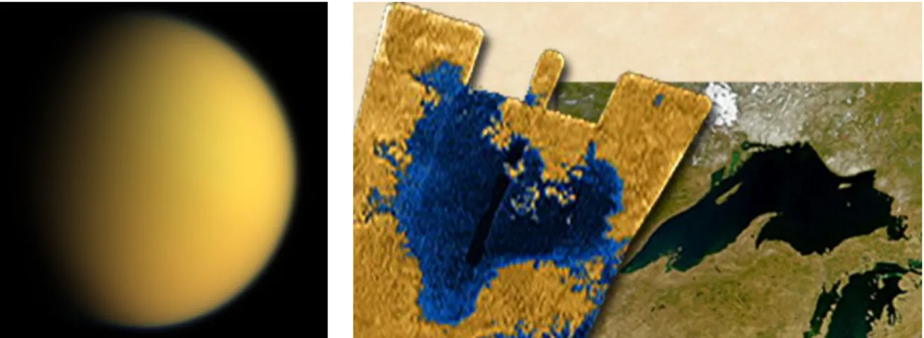
The successes celebrated by ESA, NASA over the last decade, and more recently by the Chinese National Space Agency (CNSA), and commercial space travel firms have demon-strated new possibilities in planetary exploration, and a global competitive interest in the endeavor. It is reasonable to assume that some combination of energy-related economic in-centives, scientific impetus and perhaps even a geopolitical catalyst (akin to the Cold War space race) will induce humans to continue and expand their exploration activities solar system. The technological challenges of this eventuality require us to begin developing the technology that automates this process wherever possible, making it cheaper and faster, and circumventing current exploration bottlenecks. Adaptive sensing offers extensive re-connaissance of promising objects (both planets and moons) and their environs. Europa, Titan and Mars are three objects that hold particular promise as potentially habitable envi-ronments.
Jupiter’s moon Europa (Figure 1-1) was discovered by Galileo in 1610 and is slightly smaller than Earth’s moon. Investigation by the Pioneer, Voyager, Galileo (NASA) and New Horizons (ESA) space probes indicate that Europa includes a metallic core and a rocky mantle that are enveloped by a deep, salty, ice-covered surface ocean. These infer-ences have rendered Europa the subject of many discussions concerning future mission and potential habitability. Numerous studies and proposed missions seek to explore the subter-ranean oceans of Europa, using submersibles equipped with active sensing algorithms.
Titan (Figure 2-5) is Saturn’s largest moon and includes a dense atmosphere with stable bodies of liquid hydrocarbons on its surface. While Titan may be habitable for microbial
life, its surface liquids also suggest potential economic incentives for human space explo-ration. Titan may serve as an important energy reserve in our solar system. Ligeia Mare, a liquid body in Titan’s north polar region, is larger than Lake Superior, (Figure 2-5) and consists of a liquid mixture of methane and ethane according to data returned in 2006 by NASA’s Cassini mission.
Figure 1-1: Europa, one of the four Galilean moons of Jupiter, has been the subject of ex-tensive satellite-based research. The first photos of Europa were taken by Pioneer 10 and 11 in the early 1970s; the most recent data were collected by the Galileo probe, which crashed into Jupiter in 2003. NASA made the decision to direct it into the Jovian atmosphere to avoid the risk of it carrying terrestrial bacteria into the seas of Europa.
Mars (Figure 1-3), the fourth planet from the sun, was named for its red color which evokes the Roman god of war. The planet’s landscape is characterized by volcanic fea-tures, impact craters and a giant rift likely caused nascent extensional forces, the Valles Marineris. Recent orbital and landed missions to Mars have demonstrated that liquid water once flowed on Mars and had a similar chemistry to the liquid water found on Earth. Simple organic molecules have also been detected on Mars. The Mars Curiosity Rover is currently exploring the Gale crater, with the broad directive of looking for signs and conditions for life.
Figure 1-2: As seen in the image on the right, Titan’s Ligeia Mare is larger than Lake Superior, and filled with liquid hydrocarbons (methane and ethane). Interestingly, there is some dispute over the age of Titan due to its low crater count. A low crater count could indicate that the planet’s surface was refreshed by a natural process, or that it is simply young.
Figure 1-3: Nineteenth-century astronomical observations, made with low-powered tele-scopes, led to widespread speculation that the Red Planet was not only habitable, but in-habited. More recent data, including samples taken by the Mars Curiosity Rover, have found evidence that liquid water once flowed across the planet’s surface, and its polar caps are composed largely of water ice.
1.2 Current Technological Challenges
In the current age of planetary exploration, landed and orbital missions provide data for Earth-based analysis. Few decisions are automated in this framework. Agency planning in-dicates a transition to sample return missions and eventual human exploration. Human ex-ploration will require more detailed planetary surveys using orbital, airborne, submersible and landed missions. One of the novel challenges that has arisen during the on-going MSL mission is that the shear volume of data sent by Curiosity is overwhelming the current sci-entific team assigned to processing and interpreting it. Future missions will thus require a more integrated and automated exploration model that differs from the current system in its framing of mission objectives, operational architecture and its use of algorithms.
The task of automated exploration specifically calls for an architecture and algorithms that operate from different vantage points and at different scales to achieve informational goals. The architecture and algorithms can both simulate alternatives and adapt to a chang-ing informational landscape. The planetary survey is framed as a large and complex control space addressed through both online and offline analysis. 1 The survey control space be-haves in a stochastic manner due to the evolving informational landscape. We do not know what information will be collected, nor do we know its value in terms of the mission’s in-formational goals. Uncertainties however can be quantified and minimized by algorithms. The architectures thus guides the algorithms through an evolving landscape of stochastic rewards, which is typically the value of information relative to informational goals.
1.2.1 Technical Problem
How do we improve automated decision-making given real-time constraints? This thesis focuses on decision-making for remote sensing surveys, the problem we address can be classified as an active sensing task. Active sensing addresses the problem of collecting the right information in an environment of infinite informational possibilities. This is an appli-cation of adaptive sampling techniques, applied to real-world problems of remote-sensing
1Online refers to real-time simulations and action in the real-world environment whereas offline refers
data collection similar to that described in Krause and Guestrin [2009]. It mathematically defines the optimal solution of the active sensing problem. The findings of this thesis are therefore relevant to anyone who would like to optimize according to an informational criteria.
Exploration tasks applied to large-scale environments also face an infinite number of possible actions to take. How do we decide among these alternatives using information gathered from the environment and simulated through learning models? This thesis de-scribes an architecture for the active sensing problem, and goes on to design and test several appropriate optimization algorithms using terrestrial information-gathering appli-cations and a hypothetical aerial survey of Mars. Here, we apply an algorithmic mech-anism we call information guides to a Monte Carlo search algorithm. Decisions tend to focus on the known, and assume that the optimal path of action is evident from the value function. Information guides explicitly incorporate the unknown into decision-making and offer alternatives when the optimal path is not evident. Information guides use uncertainty concerning an observation derived from a posterior distribution (or current reality as we know it) to guide the search through a set of actionable alternatives in a given situation. This method offers a novel way of applying empirical observations to reoptimize the value function concerning a particular decision (see below). Previous research concerning de-cision making in uncertain environments using value functions and simulated models is summarized in Sec. .
Monte Carlo (MC) information guides
Adaptive sampling is the mathematical approach to selecting the right samples (see Guestrin et al. [2005] and Bush et al. [2008a]). In this thesis we develop and test appropriate op-timization algorithms for solving the adaptive sampling problem. The thesis describes a novel algorithmic mechanism we call information guides. Information guides are ap-plied to a Monte Carlo planning algorithm and help integrate online and offline computer simulation models. The mechanism and applications described here demonstrate the key innovation of approximate planning in real time for remote sensing operations.
and compare it to the uncertainty of alternatives. We assume that the ’correct’ or most de-sirable decision offers greater rewards than an alternative decision. Information guides ad-ditionally may reveal alternatives that hold promising outcomes. How do we avoid subjec-tive resolution of these different outcomes? Given the right inputs and software, a computer can quantify the alternatives assigning them values that can be directly compared. Online search is an everyday application wherein information guides steer search algorithms to appropriate content. The ideas explored here thus apply to much broader information and planning applications.
Architecture
The technical challenges of defining our problem space are primarily ones of architecture and framing. Given our overriding task, how do we design and frame a complex plan-etary survey? This challenge calls for a framework that meets informational needs and dynamically adapts to a landscape of stochastic rewards. Properly framing this problem means defining our strategy, routing sensors and incorporating the information they gather into our model. Active sensing at different scales and resolutions also calls for different approaches. Our proposed solution consists of a 3-level hierarchy presented in Chapter 2, which describes how large scale adaptive sampling problems are parsed and framed so as to address unique challenges that at different scales and with different types of sensors.
1.3 Unifying Theme: Incorporating uncertainty reduction
into decision making
The unifying theme of this thesis is uncertainty quantification and minimization. Explo-ration seeks to reduce or constrain what we do not know. As we explore, our knowl-edge about previously unknown areas and phenomena increases, while our uncertainty de-creases. In a more specific context, a planetary survey must focus on mission objectives such as finding habitable conditions on another planet. The principle of guidance by mis-sion objective is also applicable to other levels of decimis-sion-making. Exploration requires
a clear and quantitative (wherever possible) understanding of what we know and its asso-ciated uncertainty. Only then can we proceed upon a course of action for improving our understanding. Likewise, as we explore the unknown, we gain a better awareness of the existence of things we do not know. This idea is captured in the following statement made by U.S. Secretary of Defense Donald Rumsfeld during a press briefing in February of 2002:
T
HEU
NKNOWN(S
EELY[2003])
As we know,
There are known knowns.
There are things we know we know. We also know
There are known unknowns. That is to say
We know there are some things We do not know.
But there are also unknown unknowns, The ones we don’t know we don’t know.
Donald Rumsfeld
These remarks were controversial at the time given public concern about the quality of planning that went into the invasion and occupation of Iraq. The actual statement itself was a concise and accurate description of the situation (if not a little too honest for a press brief-ing) and incisively conveys the nature informational uncertainty and how we conceptualize parameters from prior distributions. There is uncertainty in our knowledge with respect to the current situation, i.e., the state (the known unknowns). The existence of this uncertainty and our acknowledgment that the state is not fully represented in our current understand-ing indicates additional uncertainties (the unknown unknowns). Accurate representation of uncertainty in our situational model or state enhances mission decision-making. We can thus use knowledge more effectively when we fully understand the nature of its uncertainty.
We can also use properly characterized uncertainty to determine where to focus future data collection efforts.
Uncertainty reduction can also be used to enhance specifications of mission objectives. This functionality arises from how we assign a value to minimum success criteria. We can quantify for direct comparison, the outcomes from a strategy or path of action as well as those of an alternative strategy, including uncertainty for both. We then use that awareness to simulate through viable alternatives, potentially enhancing our understanding of these alternatives, and identifying the most rewarding path of action. In Chapter 3, we introduce Algorithm (Sec. 3.8) and specify how it performs these operations. The process of reduc-ing the uncertainty associated with our optimal decision is guided by decision uncertainty information.
Kurt G¨odel, the parent of modern mathematical logic, searched for certainty but could only prove uncertainty, thus proving that there are some things we can never know for sure. Given its persistence, I prefer the approach of embracing uncertainty at every level in problem solving. In doing so, we make better decisions with respect to some of human-kind’s greatest challenges and endeavors.
1.4 Tasks: Enhancing exploration strategies and
address-ing uncertainty
This thesis contains the following elements and discussions intended to enhance explo-ration strategies and address uncertainty:
• Formulates active sensing at each level as a Markov Decision Process. • Develops a new Monte Carlo planning algorithm using information guides • Describes a 3-level hierarchy architecture for active sensing problems
• Demonstrates the functionality of the architecture by applying it to marine explo-ration and disaster relief opeexplo-rations
• Outlines rationale for a compact representation and develops a discovery method that includes uncertainty representation
1.4.1 3-level hierarchical architecture for active sensing problems
The 3-level Hierarchy
Real world active sensing problems include planetary exploration and Earth-based endeav-ors such as submarine exploration and disaster relief. These cover large geographic areas, incorporate many different types of information and thus require multiple sensor types. The complexities of the real world require a sophisticated, multi-scale architecture.
Figure 1-4 shows a 3-level hierarchy designed for exploration of an object like Europa. The 3-level hierarchy includes synoptic, mesoscale and microscale aerial designations. The synoptic level covers the maximum area addressed in the survey, which could be planetary in scale, or the scale of an ocean basin or the combined area of several states affected by a disaster. This scale would range in practice from about 103 to 106 km (in the case of Europa). The mesoscale level covers an intermediate area, and the microscale level covers the smallest area that can be addressed by the algorithms described here, in a non-trivial manner. A microscale sensor would cover an approximate area of a square kilometer. The mesoscale sensor would thus cover areas ranging from 10 - 103 km. In the applications described in Chapter 2, sensor coverage at the synoptic level is provided by a satellite. Coverage at the mesoscale and microscale levels is provided by an autonomous aircraft or submersible. The system works as follows: The satellite coarsely surveys a large swath of Europa’s surface. That information is processed and relayed to a group of vehicles which then deploy to the areas that are most likely to meet mission objectives. The vehicles survey the areas and return information for the next iteration of discovery.
Figure 1-4: The 3-level hierarchy shown above includes a synoptic level (covering a wide area), a mesoscale level (covering an intermediate scale area) and a microscale level (cover-ing a small local area). The synoptic sens(cover-ing (satellite) optimization algorithm concentrates on dwell time and the value of the collected information. The mesoscale system is opti-mized with respect to travel time (e.g., for autonomous unmanned aircraft or other sensors). Travel and dwell time are simultaneously adjusted at the microscale to optimize free-form exploration by sensing devices.
1.4.2 Mapping each level of the architecture as a Markov Decision
Process
This thesis describes two detailed Earth-based applications of the 3-level architecture, an algae bloom ocean sensing project and disaster relief. The first application involves au-tonomous underwater vehicles (AUVs) collectively mapping the biological phenomena of algae blooms. The second application involves air vehicles surveying a disaster area in order to reporting road conditions and transportation related information to a ground crew assigned to locate and rescue survivors. In both applications, the mapping response takes place at two levels of abstraction. At one level, the vehicles are assigned and routed to the mapping locations. The second level is a sensing platform that collates the data and takes steps to maximize the amount of useful information collected. Operations from both levels can be mapped into a special type of Markov decision process, referred to as an information state Markov decision process (info-MDP).
The info-MDP formulation is especially suitable for information gathering problems because these situations are inherently a problem of imperfect information. The core
objec-tive in other words, is to improve the information state. This process can then be reduced to a state of perfect information that includes statistics measuring the available observations. Given this formulation, paths of action can be chosen according to the available observa-tions. Similar info-MDP applications can be found in Liu [2013] and Bush et al. [2008a]). Section 2.3 offers a full definition of an info-MDP. Chapter 4 describes how an info-MDP can be applied to an active sensing problem.
1.4.3 Approximate inference driven by decision uncertainty
minimiza-tion
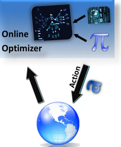
With each level of the problem framed as an info-MDP, we can then use dynamic program-ming, and specifically approximate dynamic programming (ADP) to solve the problem. Solving the problem in this case means defining a consistent policy that will control the data collection system. Chapter 2 presents a series of algorithms developed for this pur-pose, and describes a framework for applying these algorithms. We initially use ADP to develop a policy for how a sensor navigates through space and searches for information, assuming basic informational goals (i.e., accurate navigation, finding evidence of water on Mars, etc.). The second step entails modifying that policy online, during operational phases of the mission, using forward search. The online search sets initial conditions according to initial observations of the mission and searches forward through possible outcomes. The search space can be narrow or broad, shallow or deep (i.e., set according so scale level and mission objectives). The process uses the uncertainty about the expected value of each search branch to decide which actions are worthy of simulating. These information guides point the search toward promising path of action or avenues that have a high probability of yielding the best outcome. This process finally leads to use of Algorithm (see Sec. 4.6), decision uncertainty minimization via time limited branching. This algorithm applies state action value iteration with variable depth information guides and a Gaussian Process based uncertainty representation.
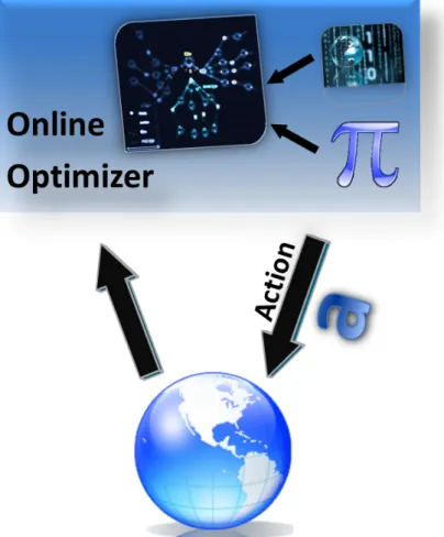
Figure 1-5 illustrates how decision uncertainty minimization via time limited branching (Algorithm ) works. The search is set according to scale level and mission objectives,
Figure 1-5: Online reoptimization algorithm : The online optimizer starts with policy π, which was produced offline. Combined with the world simulation, we can reoptimize for the current situation. For the given situation, policy π can convey its confidence in choosing one action over another, as well as which action value is most in question. Using this information as a guide, the online optimizer will simulate that action followed by a series of subsequent actions (chosen in the same manner) in order to re-estimate the value of that trajectory.
across a search space that can be narrow or broad, shallow or deep. This process uses the uncertainty about the expected value of each search branch to decide which actions are worthy of online simulation. Information guides point the search towards promising paths of action or avenues that have a high probability of yielding the best outcome.
Chapter 4 also describes two precursors algorithms related to Algorithm . Algorithm is referred to as the closed form least squares value iteration algorithm (see Sec. 5.1.5). This operation exploits the certainty equivalence property of the root mean squared error uncertainty metric in a way that accelerates the policy search algorithm. The root mean squared error uncertainty metric is a consistent alternative to Shannon entropy but has better mathematical properties. Algorithm is referred to as the closed form least squares value iteration with rollout (see Sec. 5.1.7). This operation extends Algorithm by employing a deep limited breadth online forward search. These two algorithms were natural extensions of Algorithm .
1.4.4 Demonstrating the framework in marine exploration and
disas-ter relief applications
Highly automated, intelligent devices such as drones, submersibles and landers like Cu-riosity have tremendous potential to survey and explore. Exploring unknown areas involves sensing the environment with measuring devices for the purposes of scientific discovery, reconnaissance and logistical support. In Chapter 4, we frame the active sensing problem as a 3-level hierarchy (see Sec. above) and formulate it as an information state Markov de-cision process. The chapter goes on to demonstrate this framework in a scientific research campaign and in mission support operations. The algorithms described in Chapters 3 and 4 are specifically applied and tested to a data collection effort addressing a marine algal bloom and a disaster relief scenario. Both of these applications pertain to planetary explo-ration technology, which may include exploring the oceans of Europa and liquid bodies of natural gas on Titan.
1.4.5 A Compact representation and a discovery method that
incor-porates uncertainty
Decision uncertainty minimization depends on representation that is both accurate and con-veys that accuracy as value prediction uncertainty. This in turn requires an approach to value function approximation with low uncertainty representation that also captures and expresses the uncertainty that remains (the unknown unknowns). This latter form of un-certainty is an important component of the overall un-certainty of our prediction. Identifying a solution or representation that minimizes uncertainty depends on accurate uncertainty estimates.
The utility of a value function distribution strongly depends on its having a manageable degree of variance. Excessive variance renders the ‘guidance’ steps ineffective and leads to a device response that is essentially random. Luckily the inaccuracy of a value function is a causal phenomenon: it stems from the underlying representation and can be modeled. While state-action value functions do not typically include expressions of representational uncertainty, our method constructs functions that can be assessed as ‘more sure’ in some places and ’less sure’ in others. This method provides a representation that a) accurately represents the value function and therefore has low uncertainty and b) given whatever un-certainty is present, captures that unun-certainty about the posterior value estimate. In this way, we use the uncertainty instead of ignoring it.
Chapter 3 describes how to find a value function representation with low posterior un-certainty relative to the value estimate. An online search algorithm that is guided by the uncertainty in the state-action value function requires a function that represents the un-certainty in its estimate. We also need a way to minimize the unun-certainty function. To these ends, Chapter 3 outlines the design of such a value function. Specifically, we use non-negative matrix factorization to find good basis functions that capture the structure of the underlying data. We then use a Gaussian process to map the distribution over differ-ent value ranges. We integrate these complemdiffer-entary methods with the overall objective of representational uncertainty minimization.
1.5 Prior Research and Thesis Overview
1.5.1 Prior Research
Previous research in the field of information guides, active sensing and info-MDPs has provided a strong foundation for this project and demonstrated some additional areas of development addressed by this thesis. A number of the approaches such as approximate dynamic programming (ADP) and info-MDPs have been described and applied elsewhere (Bertsekas and Tsitsiklis [1996b] and Littman [1996]). However, the research presented in this thesis makes the novel contribution of combining several of these techniques and implementing them in navigational or exploration applications. In other areas such as deci-sion uncertainty, the research described here presents new algorithms and approaches that have not been previously reported. Our initial efforts in combing offline simulation with online operations to complete adaptive sensing tasks were presented in Bush et al. [2009]. Previous researchers introduced the same approach of using ADP results to support online decisimaking. Gelly and Silver [2007] considered several ways in which offline and on-line operations could be combined to improve value function learning. Boyan and Moore [2001] demonstrated iterative re-optimization of an MDP policy that improved search per-formance. The ADP methods used here to construct offline policies as well as an exhaustive list of re-optimization strategies are surveyed by Bertsekas [2005a].
Dearden et al. [1998] also performed traditional online reinforcement learning, using information guides (uncertainty about the value function) to improve policy learning. Their model conflates environmental uncertainty and uncertainty due to approximate inference. This approach differentiates between certainty and habitual actions in decision-making, while creating an inverse model of the environment online (see Dearden et al. [1998]). In contrast, our model-based approach separates these functions, using a previously learned model, and a previously learned policy, and then tailors the policy online to the partic-ular situation. Kocsis and Szepesvari [2006] also demonstrated the use a crude form of state-action value uncertainty in guiding an online Monte Carlo sampling process. These workers (Kocsis and Szepesvari [2006]) presented an algorithm that retains information from previous states sampled to estimate uncertainty and formulate decisions. The entirely
online method and simple state space representation outlined in Kocsis and Szepesvari [2006] differs from the methods described in Chapters 2 and 3. MacKay [1992b] uses a Bayesian active learning approach related to information guides to select training samples for a neural network, and thus provided our research with ideas and approaches concerning sample selection. MacKay [1992b] is an application agnostic sample selection idea for the purpose of providing data to a function. Other methods in the reinforcement learning com-munity have developed action selection methods for the purpose of in situ learning. These methods attempt to optimize an exploration-exploitation tradeoff (Brafman and Tennen-holtz [2003],Meuleau and Bourgine [1999],Auer [2003]). These works have informed our work, as we are making a related tradeoff. However our work differs from these methods namely because our method is model-based and we learn our policy offline.
Because active sensing has so many real-world applications, numerous studies have sought to automate and develop models for adaptive sensing tasks. The works most relevant to this thesis have focused on MDPs, state-space representations and how to measure the real world environment. Murphy [1999] describes how sensor information can be used to create and update a map of a given area, and then fed into a decision-making framework concerning a given area. Thrun [2003] explored the use of occupancy grid in adaptive sensing and introduced methods similar to those outlined in Chapter 2 of this thesis. The literature concerning the use of info-MDPs in active sensing is limited and relatively recent. Mihaylova et al. [2002] used partially observable MDPs (POMDPs) to optimize active sensing algorithms and points out computational difficulties that may arise from applying MDPs to large state spaces. Ahmad and Yu [2013], Liu [2013] and Bush et al. [2008a] also use POMDPs in active sensing.
1.5.2 Thesis Overview
The remaining body of this dissertation is organized as follows:
Chapter 2 defines active sensing and applies the aforementioned algorithms into the context of two active sensing tasks. The chapter describes a hierarchical mission archi-tecture based according to different scales at which exploration tasks are carried out. We
define information state Markov Decision Processes (info-MDPs) and frame active sensing tasks as MDPs. Tasks at each hierarchal level are specifically formulated as info-MDPs. Chapter 2 also demonstrates the performance improvement of the three level approach over a single level, micro scale approach. A marine bathymetric mapping task and a hypothetical Mars exploration mission are framed as info-MDPs using this 3-level hierarchy.
Chapter 3 introduces the new algorithm of decision uncertainty minimization via time limited branching. Several precursor algorithms are discussed as background to the pri-mary algorithm. Chapter 3 defines and discusses the prior art of exact value iteration with value functions and with Q-values, approximate Q-value iteration, Monte Carlo planning in an MDP, open-loop feedback control, certainty equivalence planning and rollout. Chapter 3 also defines decision uncertainty minimization and puts it into the context of online and offline approximate dynamic programming. The chapter then discusses quantifying the un-certainty of a policy, and the dependence of its accuracy on the unun-certainty representation. It then discusses the new idea of using representational uncertainty to direct the blending of online and offline computation.
Chapter 4 defines representational uncertainty and outlines the rationale for a low un-certainty representation that also captures the unun-certainty that remains following observa-tion. The use of value function uncertainty is discussed in the context of blending online and offline decision methods. The techniques discussed include basis function discovery, linear architectures, transition matrix factoring, and uncertainty directed transition matrix factoring.
Chapter 5 describes active sensing applications using the 3-level hierarchy in greater detail. The chapter describes an active sensing task that occupies the synoptic level of the hierarchy and a task that occupies the microscale level of the hierarchy. The results demonstrate the utility of the presented methods. [Additional copy needed]
Nomenclature
Markov decision process
h•, · · · , •i = tuple brackets : ordered heterogeneous non-removable set M = hS, A, P, R, γi = Markov decision process model
S = state set
A = action set
P = state transition probability distribution
R = reward function
γ = discount factor
Pa
ss0 = probability of transitioning to state s0 from state s when executing action a
Ra
ss0 = reward associated with transitioning from state s to state s0 given action a
MDP Solutions
π∗ = optimal policy, which maximizes the value (expected future discounted
= reward) of every state
V = refers to the ethereal & theoretical true value (expected discounted future reward) over the entire state space S
Vπ(s) = average future rewards obtained when policy π is followed, starting in state s V∗(s), V
π∗(s) = optimal value of state s
¯V(s) = value lookup table where s ∈ ¯S ⊆ S
¯V = refers to the subset of points v ∈ ¯V ⊆ V pertaining to states s ∈ ¯S ⊆ S b
V = value function approximation architecture
b
V (s, a) = approximated value
Vπ(s, a) = true value under policy π
V∗(s), V
π∗(s) = optimal value
˜v = ˜V (s) ∈ ˜V = the improved value approximation obtained via a Bellman backup ¯
Q(s, a) = state-action value lookup table where s ∈ ¯S ⊆ S b
Q = state-action value function approximation architecture
b
Qπ(s, a) = true state-action value under policy π Q∗(s, a), Q
π∗(s, a) = optimal state action value
˜
Q(s, a) = the improved state-action value approximation obtained via a Bellman backup Abbreviations
info-MDP Information State Markov Decision Process
RUM Representational Uncertainty Minimization
DUM Decision Uncertainty Minimization
NMF Non-negative Matrix Factorization
GP Gaussian Process
Gaussian Process
cov(f∗) Gaussian process posterior covariance
Function Approximation
∼ = distributed according to ; example q ∼ N (µ, σ)
obs
← = realization or observation of; example bobs← B,
Glossary
3-level hierarchy A way of structuring and characterizing sensing problems at the global (synoptic), mesoscale (intermediate), and microscale (close-up) levels.
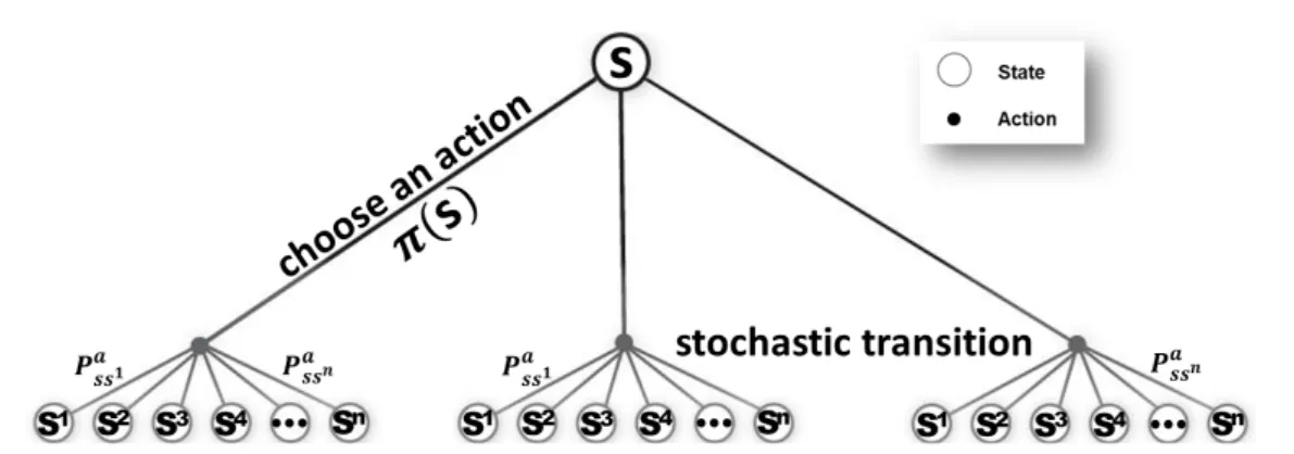
Action space The set of all possible actions A = a1, a2, ..., an, e.g. in our problems, an action entails sensing at a particular grid location.
Active sensing The application of an adaptive sample design to a sensing task. Adaptive sampling The mathematical optimization of information gathering.
Approximate dynamic programming (ADP) A method of developing control policies by approximating value functions, where those functions cannot be determined reli-ably.
Approximate value iteration An approach to learning the value function of a Markov decision process by combining function approximation and dynamic programming. This is one form of approximate dynamic programming.
Autonomy The ability of a robotic or software agent to choose its own actions, without the intervention of a human operator.
Base policy The default approach of a function or heuristic to a given problem.
Basis function An element of a basis for a function space, similar to a feature when inde-pendency is relaxed.
Bathymetric Relating to the study of underwater topography.
Belief map The probability that each space of an occupancy grid is inhabited. More gen-erally, a representation of our belief about all of a map’s parameters.
Belief or mental state A way of categorizing an autonomous agent’s awareness of its un-certainty regarding a map of its environment, via a distribution over all physically possible world states.
Bellman optimality equation A necessary condition for optimality in dynamic program-ming applications. It describes a one-step look-ahead with respect to the value func-tion.
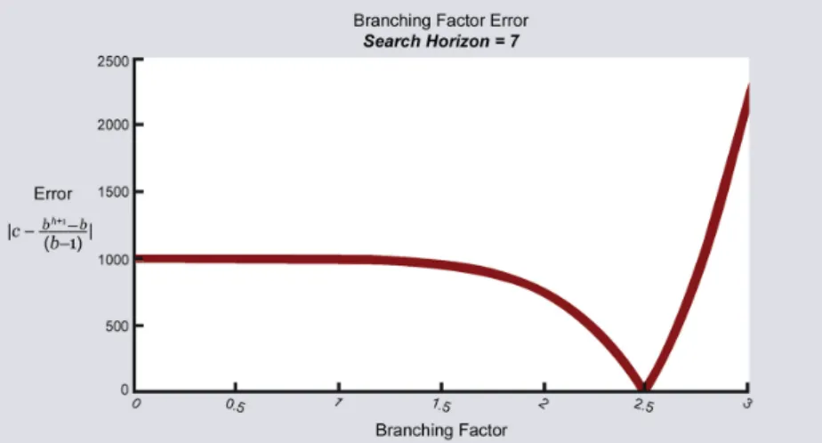
Branching factor The number of successors of a particular node, in tree-based data struc-tures.
Certainty equivalence approximation A method of reducing analytical complexity by assuming that the utility of the expected outcome is equal to the average utility over all possible outcomes.
Decision uncertainty minimization (DUM) A method of blending offline and online com-putation to improve realtime planning, by incorporating uncertainty into the online decisions regarding reevaluation of an offline policy.
Dynamic programming (DP) An approach to solving complex problems by breaking them into multiple subproblems, which are easier to solve.
Expected value In a Markov decision process, the expected value refers to the average discounted sum of rewards obtained by following a given policy from state (s). Gaussian process A stochastic process in which random variables are associated with
each point in a finite range, so that each variable has a normal distribution.
Information-state Markov decision process (info-MDP) An infinite state Markov deci-sion process that makes decideci-sions directly based on its belief about the world
Information-state partially observable Markov decision process (info-POMDP) A par-tially observable Markov decision process in which the reward is a function of the state estimate uncertainty.
Kalman filter A recursive algorithm that produce statistically optimal estimates of a sys-tem’s state from observed sequential measurements, assuming a Gaussian linear model.
Linear architecture An architecture that approximates V (s) by first mapping the state s to feature vector Φ (s) ∈ <kand by computing a linear combination of those features Φ (s) β, where β is a function parameter vector.
Markov decision process A decision making model where outcomes are ultimately stochas-tic yet an agent makes certain choices in an effort to maximize the expected dis-counted sum over future rewards.
Monte Carlo planning A method of comparing different policies by combining Monte Carlo analysis with forward search. Monte Carlo planning considers all actions at each state, but limits how thoroughly the action consequences are simulated.
Occupancy grid A mapping problem representation, where each cell in a grid conveys the likelihood that the phenomena of interest is present.
Offline planning The policies an agent learns before a mission begins, which are based upon simulated actions.
Online planning Policies generated in the field, based upon realtime simulations and ac-tions in the real-world environment.
Open-loop feedback control An approach that generates an open loop (static non-reactive) plan for the mission duration, limiting the analysis by ignoring future contingent choices.
Partially observable Markov decision process (POMDP) A Markov decision process in which the underlying state is only partially observable, so that decisions must be made using the inferred probabilistic state estimate.
Policy iteration An algorithm that calculates a sequentially improving series of policies, through evaluation, and improvement.
Q-value The value (expected discounted future reward) of taking a particular action when in a given state of a Markov decision process.
Representational uncertainty minimization (RUM) A method using Gaussian processes to capture uncertainty and factored state transition matrix based features, with the goal of finding a state-action value function representation with low posterior uncer-tainty for use in decision unceruncer-tainty minimization planning.
Rollout A method of reevaluating mission planning options by simulating ahead from each possibility. Standard rollout evaluates only the first level in the policy tree, while nested rollout allows branching at multiple levels.
Sensing task A means of surveying an area and quantifying the relevant phenomena by measuring the environment.
State The current, future, or past condition of a given system. State space The set of possible states in a dynamic system.
System dynamics A representation of the probability of transitioning from one state to another when taking an action. For example, in a sensing mission, where the map is a main part of your state, executing a sensing action will change your map and therefor your state, in some way.
Unmanned aerial vehicle (UAV) An autonomous or semi-autonomous vehicle for aerial survey and exploration.
Unmanned ground vehicle (UGV) An autonomous or semi-autonomous vehicle for ground-based survey and exploration.
Value function approximation A method of estimating a value function, where the true function cannot be accurately determined or represented.
Value function A function providing the expected discounted future reward to be gained by following a given policy.
Value The expected discounted future reward to be gained by following a given policy, from a given state. The term value in the context of an MDP solution always refers to an expectation. It is used here in the same way that value and valuation are used in
finance, where they wish to determine the present value of an asset’s expected future cash flows. The future cash flows may be stochastic, but the present value is not. Vehicle routing problem with time windows (VRP-TW) A planning problem in which
2 Active Sensing
Recent technological advances have revolutionized robotics, data storage and commu-nication in ways that call for new developments in automation. Semi-autonomous devices such as robotic landers, drones and even smart phones present us with extraordinary re-mote sensing and data collection capabilities. We can use these technologies to conduct en-vironmental surveys, or any task wherein we wish to constrain large-scale state spaces. One of the foremost challenges of this technological revolution is processing data and achieving informational goals in an efficient manner. Current technology simply offers too many data collection opportunities and too much data to review. Adaptive sensing and automation can greatly enhance the utility of remote sensing technology by optimizing its use in situa-tions where valuable information is scarce relative to the overall information content of the environment. Planetary exploration offers a good example of an exploration task wherein valuable information, such as habitable conditions or resource availability, is scarce within areas that we can access and survey. This thesis seeks to utilize advances in remote sensing and manage their proliferating data collection capabilities to efficiently attain informational objectives.
Chapter Outline
Adaptive sensing and other automation strategies are relatively untested as methods to solve these problems, partly due to the novelty of advanced sensing technology. This chapter describes how to apply adaptive algorithms within a planetary exploration architecture. An autonomous bathymetric mapping application provided a foundation for remote sensing tasks. This application informed a larger application task of exploring the surface of Mars. Section 2.1 begins by defining terms used in the chapter as they relate to the marine exploration and planetary survey applications. For the intermediate and small-scale state spaces, we categorized adaptive sensing into vehicle routing and exploration tasks. These two categories are described in Section 2.1, and later in Sections 2.4.2 and 2.4.3. Sec-tion 2.1.1 goes on to describe how adaptive sensing can be framed as an informaSec-tion state Markov Decision Process (info-MDP) and how info-MDPs can be optimized to perform
ex-ploration tasks. Adaptive sensing presents different challenges as the spatial scale changes. Section 2.2 reviews info-MDPs in detail, and formulates the active sensing task for survey-ing Mars as an info-MDP. Section 2.3 describes the assumptions and practice of adaptive planning for a marine bathymetric mapping task and a hypothetical survey of Mars. Section 2.3.1 describes how algorithms can implement low level, real time adjustment to informa-tion gathering plans on a short time scale and according to several variables in order to en-hance marine bathymetric mapping. Section 2.3.2 describes the function and effectiveness of adaptive planning strategies designed for a hypothetical Mars survey. In this application, we assumed coordinated use of current or proposed satellite and airborne technologies and discusses an active sensing platform that determines and optimal strategy in an evolving environment. Both the vehicle routing and information collection tasks described in Sec-tions 2.1 can be framed as info-MDPs, in which a policy can be learned offline, using a simulated model of the state space. These tasks can be modeled as info-MDPs because the chosen control actions are necessarily conditioned on previously collected observa-tions(see Littman [1996], Bertsekas and Shreve [1978] and Bertsekas [2005b]). Combined with adaptive sensing algorithms, our previously described 3-level hierarchy addresses is-sues of how to expand the focus of sensing tasks to planetary scales. Section 5.1.1 describes how the 3-level hierarchy integrates multiple sensors at different spatial scales, which can then be addressed as info-MPDs.
2.1 Background
This Section describes the use of active sensing and sample design in information collec-tion problems. In tradicollec-tional remote sensing tasks, the sampling design is fixed prior to beginning the task, and follows an open loop based on a priori guidance (Aeronautics and Center, for Advanced Computer Science, Bresina et al. [2005]). An adaptive sample design changes based on observations collected during the current survey or sensing task.
A
CTIVES
ENSINGActive sensing is the application of an adaptive sample strategy to a sensing task. A sample strategy is the procedure used to select a sample. A sensing task is an operation in which each sample measures the environment (i.e., for survey and mission support).
See Fedorov [1972a], MacKay [1992a], MacKay [1992b], Thompson et al. [1996], Thompson and Collins [2002], MacKay [2003], Krause and Guestrin [2007], and Powell and Ryzhov [2012].
Sensing tasks allow us to survey an area and quantify the phenomena most relevant to mission planning and execution. A sensing task, such as a survey, typically observes relevant phenomena that can be characterized by one or more spatial variables. With adap-tive sampling, the sampling procedure depends on the values of the observed variables relative to mission objectives. The sampling plan adapts to observed patterns in order to optimally survey the phenomena. Sensing tasks differ in terms of how much the decision and planning processes are affected by incoming information. In the case of current terres-trial surveys, including the marine exploration example described in the following section, information collection is primarily determined by a priori survey goals. The theoretical Mars exploration application described in Section 2.3.2 calls for an additional sensing task whose guidance system responds to information in real time as it conducts a survey.
Given the different tasks implicit in larger scale exploration activities, we categorize remote sensing activities as vehicle routing problems (See Soloman [1987], Lolla et al. [2012], Desrochers et al. [1988], Kilby et al. [2000], Kolen et al. [1987], Larsen [1999], Ralphs et al. [2003], and Fisher and J¨ornsten [1997]) or adaptive sensing problems (See
Lermusiaux [2007], Mihaylova et al. [2003], Mihaylova et al. [2002], Ahmad and Yu [2013], Murphy [1999] and Krause and Guestrin [2009]) according to informational ob-jectives, sometimes referred to as freeform exploration. Vehicle routing refers to naviga-tional guidance provided to a set of vehicles in order to perform the optimal survey of an area. Vehicle routing treats parameters such as travel time, number of vehicles and area to be surveyed in a different manner than adaptive sensing according to information objec-tives. This latter activity receives guidance according to real-time information collection and synthesis, and less according to fuel constraints and the current state rewards that deter-mine vehicle routing procedures. These two categories comprise the first order challenges for adaptive sensing at the meso- and micro-scale, and are explained in greater detail in Sections 2.4.2 and 2.4.3.
One of the advantages to using fully autonomous agents is their ability to perform adaptive planning and execution. These plans evolve with information gathered from the environment and in so doing, perform better than static planners when changes in util-ity are modeled at all levels of change in the environment. In order to perform adaptive planning, we have used a hierarchical method that combines a meso scale planner for adap-tive sampling, with a low level, kino-dynamic path planner that implements the sampling planning(L´eaut´e and Williams [2005a]) The architecture offers three critical features that benefit large scale information gathering tasks. First, the upper level is performing adap-tive sampling, which compensates for new information about the environment. The two lower levels divide the planning into two problems with smaller state spaces, and fewer constraints. Third, online replanning at both levels enables the system to compensate for approximation errors introduced by he two level hierarchy, and because of model. Section 5.1.1 describes the development and deployment of the architecture.
2.1.1 Technical Problem
Vehicle routing (See Lolla et al. [2012]) and adaptive sensing are both computationally in-tensive. The decision uncertainty minimization algorithm described in Chapter 3 addresses this problem for all levels of planning. This chapter focuses on the task of characterizing an
environment using adaptive sensing (Lermusiaux [2007]). Two real-world applications of adaptive sensing, satellite-based ocean sensing and unmanned aerial vehicle (UAV)-based mapping for search and rescue mission (detailed in Sections 5.1 and 5.4) demonstrate how adaptive sensing translated into large applications.
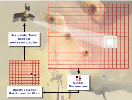
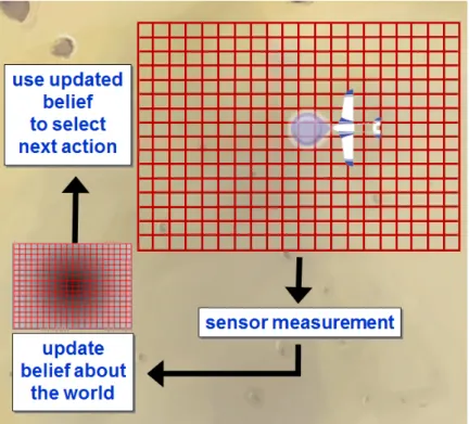
In the case of planetary surveys, the sensing platform ultimately attempts to build the most accurate map with respect to a mission-related reward metric, which in this case could be described as map uncertainty. In order to minimize uncertainty, the system state must include an expression for map uncertainty. More generally, the state must contain a mental state or projection of the optimizing model. This projection is distributed over all physi-cally possible world states and is referred to as an information state because it reflects the totality of all information collected thus far or some sufficient statistic thereof. Given that the projection is represented as a sufficient statistic with respect to optimal behavior, we can define the information state as an information state Markov decision process (MDP). An info-MDP is an infinite state MDP that makes decisions directly based on its own in-formation state, which allows it to optimize according to aspects of the real world map that positively affect mission objectives.
2.2 Modeling active sensing as an information state Markov
decision process
Thus far this chapter has operations in which agents plan automatically and online in order to gather information. Up to this point we have also assumed that exploration targets have arbitrarily pre-determined informational value. An actual survey of Mars would involve much greater uncertainty with respect to the informational value of potential exploration sites. An appropriate plan for larger scale survey would seek to provide the most ’use-ful’ information. To formalize this problem, we specify ’use’use-ful’ in terms of an objective function over ’information states’. The planner then generates a plan that maximizes this objective function. In this section we argue that this planning problem should be formulated as an information-state Markov decision process.
In actual Mars exploration efforts, information value often corresponds to several asso-ciated features that offer integrated evidence of a given phenomena of interest. In the case of current Mars survey missions for example, objects or features of high information value include geomorphologic patterns that suggest the presence of liquid water, mineral classes such as sulfates that form in association with liquid water, and specific minerals, such as montmorollinite clay, that are unique to habitable aqueous conditions. Each of these fea-tures can be detected at the synoptic, meso- and micro- levels depending on their scale and concentration, but definitive identification often requires reconnaissance of associated features and confirmation with multiple sensors (e.g., imaging, geochemical analysis, etc.). How then do we survey an area for high value information in an efficient manner?
We selected an MDP approach because of its efficiency at planning a trajectory that maximizes value. To apply a Markov Decision framework to this problem, we begin by assigning each location to be surveyed an information state, which is a probability distri-bution over the states of its environment. States in the example of the Mars survey might include variable weather conditions, local geography, such as, northern plains and south-ern highlands, or geomorphic significance, such as younger versus older craters, layered rock formations and dunes. The platform can then plan and conduct measurements that maximize information rewards and reduce uncertainty. The model uses initial, synoptic or mesoscale observations to assign information states and to encode past actions and ob-servations as probabilities of informational rewards (with uncertainties) over states of the environment. These partially observable Markov decision processes (POMDPs), when an agent encodes its history of actions and observations as a probability distribution over states of the environment, can then be converted to an information state Markov decision process (info-MDP), or a fully observable problem. This section first describes the info-MDP ap-proach (Sec. 2.2) and goes on to specify the variables and operations used to construct the model (Sec. 2.2).
I
NFORMATIONS
TATEM
ARKOVD
ECISIONP
ROCESSAn info-MDP is a type of MDP in which the uncertainty regarding the real world state is represented as an MDP or a component of an MDP state. Decisions are made based on what is known and how well it is known. An agent consists of a state estimator and a policy. The state estimator incorporates the latest observation into its belief, and the policy is a function of that new belief Littman [1996].
The info-MDP differs from other methods which create a policy for every possible world state then essentially create a compromise policy based on the probability that we are in each of those states (See Sec. 3.6 for a comparison of planning methods). In an info-MDP there is a direct mapping from belief to actions. An info-MDP policy is a function of the info-state rather than the world state.
See Littman [1996], Bertsekas and Shreve [1978], Bertsekas [2005b], and Bertsekas and Castanon [1999].
Experimental Approach
Information collection problems incorporate information from past iterations, referred to as memory in this context. Consideration of past observations is preferable to treating the current observation as a true state, due to uncertainties in observations and the state’s evolving nature. In a true MDP, a subsequent state is conditionally independent of past states, given the current states. For this to hold true in a problem involving observations,
we could consider all past states as part of the ‘memory’ of the current state. Policies that do not assimilate previously collected information perform poorly on information collection tasks, relative to those that have a memory component (Littman [1996]; Section 6.2.2). Computing some statistic or belief from past observations, which approximate the required conditional independence offers a better approach.
The value function of an info-MDP captures the value of the optimal experiment design, given the known or represented facts. Optimal experimental design is the process of select-ing a set of samples or experiments so as to maximize the knowledge gained from them. A value function is the discounted future reward to be gained by following a given sequence of actions, which may include contingencies. In an info-MDP, a reward metric captures the information contribution produced by each action, to the situational model (our projected belief). The cumulative future reward for subsequent experiments such as samples, data or measurements, is thus a value function. In the Mars survey example, our sensing platform is trying to map an area with respect to a mission-related reward metric, which we model as uncertainty minimization. The agent’s belief regarding the current map uncertainty must be included in the system state in order to reward actions that reduce uncertainty. This belief represents a distribution over all physically possible world states. The optimizing agents belief is an information state because it incorporates the sum total of all the information it has collected thus far. By representing the agents belief with a sufficient statistic with respect to optimal behavior, we can define an info-MDP (Littman [1996]), which includes the agents awareness of its own information state, given the uncertain world state. This framework rewards actions that leads to a better information state. See MacKay [1992a] for more information.
Information-state Markov Decision Processes: Variables and operations
Uncertainty minimization is a key objective of the information gathering problem described here. An MDP assumes that the state of the world is fully observable, but information-gathering must often estimate the world’s state. How do we construct a model that captures world state uncertainty? The most general formulation of planning with uncertainty is the partially observable Markov decision process (POMDP). A POMDP is defined as a tuple
(S, A, O, Pa
ss0, Rass0, Zsa0o, γ), where S, A, and, O are the set of states, control actions, and
observations. Pa
ss0 is the probability of getting to state s0when taking action a in state s and
Ra
ss0 is the corresponding scalar reward. Since states are not observable, Zsa0o provides the
probability of receiving observation o when taking action a and reaching state s0. The γ term is used as the discount factor to bound the total accumulated reward. Since the agent is unable to observe the state, it maintains a probability distribution over states called the belief. Hence a policy (π) maps such beliefs to actions. If the reward function depends on the belief, which is often the case for the exploration tasks the state itself must reflect the belief, since R : S × A × S → R. On the other hand, if the observation model is known a priori, the belief can be updated on each time step, given the observation. These facts allow us to operate in a fully observable domain, where the new state is the belief itself and the new transition model incorporates the observation model.
This formulation specifies the problem as an info-MDP, where the MDP is defined as a tuple (S, A, Pa
ss0, Rass0, γ). Any situation with imperfect state information can be reduced to
a problem where the state is fully observable (Bertsekas [2005b] p. 218). The new problem makes a decision based on the information state, which is fully observable. Thus, the problem is equivalent to a problem where the state is fully observable. Bertsekas and Shreve [1978] first introduced the info-MDP and Cassandra et al. [1994] and Littman [1996] offer detailed descriptions of it.
2.2.1 Active sensing as an information-state MDP
The overall objective of active sensing objective is to construct an accurate map upon which exploration decisions are based. The objective function must therefore include some mea-sure of map accuracy given an unknown true world state, and the overall objective and immediate reward must be information related. In framing this problem as an info-MDP, our task entails measuring real-world variables in order to maximize the value of informa-tional in a given area.
Suppose we wish to measure and map the presence of some phenomena of interest over a geographic area. We can think of this problem as creating an accurate occupancy map
and model the area as a set of n cells arranged as a rectangular grid.
• State Space: S = [0, 1]n where n is the total number of grids and s
i indicates the probability of grid cell i occupancy.
• Action Space: A(s) ⊂ A = {1, 2, . . . , n}, where an action a is to sense a particular grid location a and the surrounding cells. A(s) ⊂ A is the set of currently available sensing actions, those immediately reachable from the current location.
• System Dynamics: The system dynamics represents the probability of transitioning from information state s to s0 when taking sensing action a, where s0 is our new information state, given sensor return w (following Equation 2.2). Therefore, the transition probability is equal to the probability of getting sensor return w given ac-tion a in state s.
Pa
ss0 = P (w|s, a) (2.1)
such that
s0 = P (x|w) = αP (w|x, a)s. (2.2)
Note that in the continuous case, s is a probability density function over continuous variable x and in the general case the Bayesian update (Equation 2.2) may require integrating over x. When we can compute the expected costs of state estimation er-ror, we may select sensing actions specifically to reduce those costs. For example, suppose an autonomous Mars airplane team is tasked with finding interesting sites to investigate. Locations are optimized according to signal strength. Furthermore, iden-tifying safe traversable paths for a ground rover to get to these locations is equally important. On the other hand, when we cannot compute the expected cost of state estimation errors, we use an information theoretic approach of maximizing reduc-tion in uncertainty. One of the most common measures of reducreduc-tion in uncertainty is