HAL Id: hal-00298233
https://hal.archives-ouvertes.fr/hal-00298233
Submitted on 17 Apr 2007
HAL is a multi-disciplinary open access
archive for the deposit and dissemination of
sci-entific research documents, whether they are
pub-lished or not. The documents may come from
teaching and research institutions in France or
abroad, or from public or private research centers.
L’archive ouverte pluridisciplinaire HAL, est
destinée au dépôt et à la diffusion de documents
scientifiques de niveau recherche, publiés ou non,
émanant des établissements d’enseignement et de
recherche français ou étrangers, des laboratoires
publics ou privés.
Location of the River Euphrates in the Late Miocene;
dating of terrace gravel at Shireen, Syria
T. Demir, M. Pringle, S. Yurtmen, R. Westaway, D. Bridgland, A. Beck, K.
Challis, G. Rowbotham
To cite this version:
T. Demir, M. Pringle, S. Yurtmen, R. Westaway, D. Bridgland, et al.. Location of the River Euphrates
in the Late Miocene; dating of terrace gravel at Shireen, Syria. eEarth, 2007, 2 (1), pp.27-34.
�hal-00298233�
Technology, Cambridge, MA 02139-4307, USA
3Department of Geology, C¸ ukurova University, 01330 Adana, Turkey
4Faculty of Mathematics and Computing, The Open University, Eldon House, Gosforth, Newcastle-upon-Tyne NE3 3PW, UK 5School of Civil Engineering and Geosciences, Newcastle University, Newcastle-upon-Tyne NE1 7RU, UK
6Department of Geography, Durham University, Durham DH1 3LE, UK 7School of Computing, University of Leeds, Leeds LS2 9JT, UK
8Birmingham Archaeology, University of Birmingham, Birmingham B15 2TT, UK 9School of Earth Sciences and Geography, Keele University, Staffordshire ST5 5BG, UK
Received: 31 August 2006 – Published in eEarth Discuss.: 12 December 2006 Revised: 22 February 2007 – Accepted: 10 March 2007 – Published: 17 April 2007
Abstract. We report gravel of the River Euphrates, capped
by basalt that is Ar-Ar dated to ∼9 Ma, at Shireen in northern Syria. This gravel, preserved by the erosion-resistant basalt, allows us for the first time to reconstruct the history of this major river during the Late Miocene. In response to pro-gressive regional surface uplift, the Euphrates extended SE by ∼800 km between the early Middle Miocene, when the coast was near Kahramanmaras¸ in southern Turkey, and the Pliocene, when it lay in western Iraq, east of the Arabian Platform uplands.
1 Introduction
Due to their action of transporting the products of erosion, and thus facilitating the isostatic rebound that has contributed to the systematic growth of topography in the Late Ceno-zoic, large rivers have had a significant role in long-timescale global change. However, relatively few pre-Pleistocene up-land localities are known with demonstrable evidence that an extant major river was present. Examples include: Aus-tralian rivers with records back to the Palaeogene (Stevenson and Brown, 1989; Nott, 1992); rivers in eastern Europe that are documented back to the Late Miocene (e.g., Matoshko et al., 2004); and the Colorado in the SW USA, which has been reconstructed back to the Middle Miocene (e.g., Mc-Kee and McMc-Kee 1972; Lucchitta, 1979). However, in most other regions one can only infer roughly where rivers once
Correspondence to: R. Westaway
(robwestaway@tiscali.co.uk)
flowed from the provenance of sediment reaching lowland or offshore depocentres, with no direct supporting evidence.
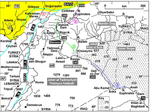
With a length of ∼2800 km, the Euphrates is the longest river in SW Asia. From its source in NE Turkey it flows ini-tially west and south, then SE across the Arabian Platform in Syria and Iraq (Fig. 1) to the Persian Gulf. The Ara-bian Platform was a marine depocentre until the Middle-Late Miocene (e.g., Lovelock, 1984). Fluvial sand and gravel are widespread near its northern margin around Kahramanmaras¸ (e.g., Derman, 1999; Fig. 1), dated to the early Mid-dle Miocene (Langhian; ∼16 Ma) using interbedded basalt (Arger et al., 2000) and shallow marine sediments (Karig and Kozlu, 1990). The diverse clast content, including metamor-phic lithologies not found in situ in the Arabian Platform, indicates that a major river, draining at least part of the mod-ern upper Euphrates catchment, reached the sea here at this time (1, Fig. 1).
A staircase of Late Cenozoic fluvial terraces records the evolution of the Euphrates along its present course, indi-cating net incision by ∼110 m at Birecik (Sanlaville, 2004; Demir et al., 2004), near the Turkey-Syria border, and by
∼70 m at Khan al-Baghdadi (Tyr´aˇcek, 1987) at the eastern
margin of the Arabian Platform uplands (Fig. 1). Across eastern Syria (around and below Raqqa, where much less incision has occurred since both the Late Pliocene and the late Early Pleistocene; Westaway et al., 2005a) and west-ern Iraq, the modwest-ern Euphrates valley is flanked by extensive older stacked fluvial gravels (attributed to the ancestral Eu-phrates from their diverse clast content), which indicate the course of the river in the Early Pliocene (e.g., Besanc¸on and Geyer, 2003; 3, Fig. 1). However, its modern course farther
28 T. Demir et al.: Late Miocene River Euphrates
Fig. 1. Map locating the study area in relation to the River Euphrates (with its altitude a.s.l. marked at key sites) and the active left-lateral
faults (after Westaway, 2004, coloured light blue) bounding the Arabian (AR), African (AF) and Turkish (TR) plates. Mountain ranges forming by distributed shortening along the DSFZ are: L.M., Lebanon Mountains; C.R., Syrian Coastal Range (Jebel Nusayriyah); and A.M., Amanos Mountains. K.V. denotes the Karasu Valley. The Anatolian crustal province is shaded yellow, except where offshore. The suture of the Neotethys Ocean follows its southern margin, also marking the northern limit of the Arabian Platform. Ophiolitic rock (chert, basalt, etc.) from this suture zone and metamorphic rock (quartzite, calcschist, etc.) from Anatolia, farther north, are major constituents of the Euphrates gravels. Cenozoic folding, superimposed on regional uplift, has created the uplands within the Arabian Platform labelled in grey. In the Key, (1) denotes outcrop of the Upper Fars Formation; (2) denotes concentrations of stacked fluvial sand and gravel, from the early Middle Miocene and (?) Late Miocene. In the figure, 1, 2, 3 and 4 indicate the Euphrates in the Middle Miocene, Late Miocene, Pliocene, and Pleistocene, respectively coloured red, green, dark blue and purple. 1, 3 and 4 are from previous work; 2 is inferred in this study.
upstream (4, Fig. 1) is no older than ∼2 Ma, from the ratio of the offset of its gorge through the East Anatolian fault zone (EAFZ) to the total slip on this fault zone (e.g., Westaway, 2004).
There is thus a significant information gap, spanning the Late Miocene and more, for which the geometry of the Eu-phrates has been obscure. One view (Arger et al., 2000) has been that it terminated in a large palaeo-lake north of the modern Atat¨urk Dam (Fig. 1). Another possibility, suggested by the modern drainage geometry (Fig. 1), is that it flowed SW into the Mediterranean Sea, along either the Karasu Val-ley or the line of the modern River Ceyhan (Fig. 1), be-fore being diverted eastward, possibly due to the initiation at ∼4 Ma of the modern geometry of the northern Dead Sea Fault Zone (DSFZ), which is strongly transpressive, with left-lateral slip accompanying localised surface uplift (e.g., Westaway, 2004; Seyrek et al., 2007). The most recent esti-mate of the initiation of this modern geometry of strike-slip faulting is 3.73±0.05 Ma (Westaway et al., 2006a), based on evidence from the SW part of the EAFZ to the east of
Kahramanmaras¸ (Fig. 1). Previous work on reconstructing Plio-Pleistocene fluvial systems in Syria (Bridgland et al., 2003) and Turkey (Westaway et al., 2004, 2005b, 2006b) has required the documentation of fragmentary sedimentary sec-tions, often with dimensions of only a few square metres. We have identified one such site, at Shireen in northern Syria (Fig. 1), where fluvial gravel – attributed to the Euphrates and preserved due to capping by basalt – has been dated to
∼9 Ma by Ar-Ar dating of the basalt, thus demonstrating the
location of this major river in the Late Miocene.
2 Regional geology and tectonics
Most outcrop in this part of northern Syria (Fig. 2) consists of Cenozoic marine carbonates. Late Eocene chalky and clayey limestone is overlain by ∼70 m of Oligocene hard crystalline limestone and dolomitic limestone (Ponikarov et al., 1967). During deposition of these sediments the northern Arabian Platform formed a seaway linking the Mediterranean Sea and Indian Ocean.
Demir et al. (2007) for details of the locations and heights of terrace deposits selected as representative of terraces QfII and QfIII in this area. Notation in brackets is after Oguchi (2001). Incision rates are calculated relative to 7 m above modern low-stage (autumn) pre-dam river level. MIS denotes the marine oxygen isotope timescale.
Unconformable Miocene marine limestone was assigned by Ponikarov et al. (1967) to the Jeribe Formation. This stratigraphic unit has regional significance, extending from Syria to Iran, dated to the early Middle Miocene (Langhian; James and Wynd, 1965; Alsharhan and Nairn, 1995). Diverse carbonate facies are evident, suggesting rapidly-changing shallow-marine conditions. This limestone is over-lain by deposits assigned by Ponikarov et al. (1967) to the Lower Fars Formation, another regionally significant unit, of late Middle Miocene (Burdigalian) age (James and Wynd, 1965; Alsharhan and Nairn, 1995). Around Shireen this consists of interbedded green calcareous clay and marl, red mudstone and white limestone with occasional gypsum lay-ers, and is no more than a few tens of metres thick. Far-ther north near the Turkish border, conglomerate and cross-bedded sandstone are also assigned to this unit. These sediments indicate marginal marine conditions with input of clastic sediment from the north. By this time a land bridge connected Arabia with Turkey (between Aleppo and Kahramanmaras¸; Fig. 1), isolating the Mediterranean Sea from the Mesopotamian Basin of Syria, Iraq and Iran.
No younger stacked sediments are found in this area. However, east of Raqqa (Fig. 1) there is extensive outcrop of the Upper Fars Formation, consisting of up to ∼250 m of clay, siltstone, fine-grained sandstone and gypsum. These deposits record a marine to lagoonal or lacustrine transition, which occurred in the Late Miocene (James and Wynd, 1965; Alsharhan and Nairn, 1995). Younger stacked terrestrial sediments, assigned to the Pliocene and correlated with the Bakhtiari Formation of Iraq, also crop out widely in eastern Syria, notably around Deir ez-Zor. These consist of sand and gravel, with a general upward-coarsening trend, with calcare-ous clay and gypsum interbeds (Ponikarov et al., 1967), indi-cating a lacustrine depocentre with fluvial input. The clasts include igneous and metamorphic rocks derived from eastern Turkey, indicating that the Euphrates reached the area at that time (3, Fig. 1).
Fig. 2. Geological map of the Shireen area, after Ponikarov (1966),
as modified by Oguchi (2001), showing the location of basalt sample 03SY09. The underlying fluvial gravel was not recog-nised in this mapping, presumably because the modern quarry had not yet opened. 1 indicates the inferred course of the Eu-phrates before this basalt eruption; 2 indicates how we sug-gest it adjusted immediately afterward. The Euphrates was lo-cally ∼300 m a.s.l. in the southern part of this map area, ris-ing to ∼305 m a.s.l. in the north; construction of the Tishreen Dam in the 1990s has impounded it at ∼325 m (see Fig. S2 in the online supplement (http://www.electronic-earth.net/2/27/2007/ ee-2-27-2007-supplement.zip) for more detail). Pleistocene grav-els are labelled consistent with Table 1; based on its mapped extent in relation to the topography, the deposit assigned to terrace QfIII is ∼45 m thick, its base and top beting ∼430 and ∼475 m a.s.l. (see Demir et al., 2007, for more details). Shireen is an abbrevi-ated phonetic spelling of the name of the village in our study area. Alternative spellings, in full, transliterated from Arabic on maps and other publications, include Shirrin esh-Shemaliyeh, Shirrin ash-Shamaliyah, Serrin Esh-Shamaligeh, Surrien Shamali, and Sarine Shamali.
30 T. Demir et al.: Late Miocene River Euphrates
Fig. 3. Cross-section through the Euphrates terrace staircase,
pass-ing ∼5 km SSW of Shireen (crosspass-ing the river valley near the SW corner of Fig. 2), modified after Oguchi (2001) (cf. Table 1). The deposits forming Euphrates terrace QfIII are projected into this sec-tion line from their locasec-tion near the NW corner of Fig. 2, assuming a downstream decrease in river level of 5 m, consistent with a typi-cal downstream gradient of the Euphrates channel of ∼0.3 m km−1.
Following the Eocene closure of the Neotethys Ocean (see Fig. 1 caption), northward motion of the African Plate (AF) was accommodated for tens of millions of years by dis-tributed crustal shortening. The principal shortening mech-anism within the Arabian Platform involved folding of an-ticlines above blind reverse faults (e.g., Rigo de Righi and Cortesini, 1964; Chaimov et al., 1990; Cos¸kun and Cos¸kun, 2000). The DSFZ developed in the early Middle Miocene (∼19 Ma; Garfunkel, 1981), separating the Arabian Plate (AR) from the African Plate. Initially, it seems, its left-lateral slip was taken up by continued distributed shortening within the northern Arabian Platform (Westaway, 2004). At
∼4 Ma (Westaway, 2004; Westaway et al., 2006a; Seyrek et
al., 2007) the modern throughgoing linkage (Fig. 1) between the DSFZ and EAFZ developed, since when many of these anticlines have been inactive. However, the northern DSFZ is strongly transpressive (e.g., Westaway, 2004; Gomez et al., 2006; Seyrek et al., 2007). The component of distributed shortening along it has caused localised growth of topogra-phy (e.g., Westaway, 2004), notably in the Lebanon Moun-tains, Syrian Coastal Range and Amanos Mountains (Fig. 1). Superimposed on all these local effects has been progressive southward regional tilting of the land surface, due to the typ-ical northward increase in rates of post-Middle Miocene re-gional uplift (e.g., Arger et al., 2000). All these factors, plus the need to maintain a downstream channel gradient, must be considered when reconstructing the evolution of the Eu-phrates.
3 The Shireen site
The site is in the left flank of the Euphrates valley (∼35 km S of the Turkish border, ∼60 km downstream of Birecik),
Fig. 4. (a) Field photograph, looking west at the Shireen quarry
exposure of gravel and overlying basalt. T. Demir provides scale.
(b) Field sketch of this exposure.
∼4 km E of the modern river, whose course locally bends
from SE to SW (Figs. 1, 2). This region is transected by both SE- and SW-trending reverse faults, which took up crustal shortening prior to the initiation of the EAFZ, causing lo-calised offsets and warpings in the stacked Cenozoic sedi-ments. The present local relief results from this deformation, differential erosion (the Eocene clayey limestone being eas-ily erodable) and fluvial incision. Young incision is revealed by Euphrates terraces (Table 1), the most prominent around Shireen being QfII and Qf0 (Fig. 2), the latter assigned to MIS 2 (Fig. 3)
About 2 km SE of Shireen, the road along the Euphrates valley passes through basalt, which unconformably overlies the stacked Middle Miocene succession (Fig. 2). At UTM co-ordinates [DA 37748 47784], a track heads west to a quarry, where the basalt overlies gravel (Fig. 4). The up to ∼1 m thickness of gravel visible (base not exposed) is cemented and highly weathered. Clasts, set in a sandy matrix, and typically rounded to subrounded, are poorly-sorted but show stratification and some evidence of fining-upward (maximum size, ∼10 cm). Intact clasts of both chert and limestone are abundant, the largest being of limestone, but clasts of other lithologies have weathered to powder or disintegrated com-pletely, leaving voids within the matrix. The cemented nature of the deposit and the fact that many clasts are unidentifiable have precluded any stone count analysis. The basalt-gravel contact is subhorizontal, except at the left-hand (south) end of the exposure, where the basalt covers a downward bluff at the edge of the gravel (Fig. 4b). The ∼3 m of basalt is
∼370 m a.s.l.
4 Age of the Shireen volcanism and its regional context
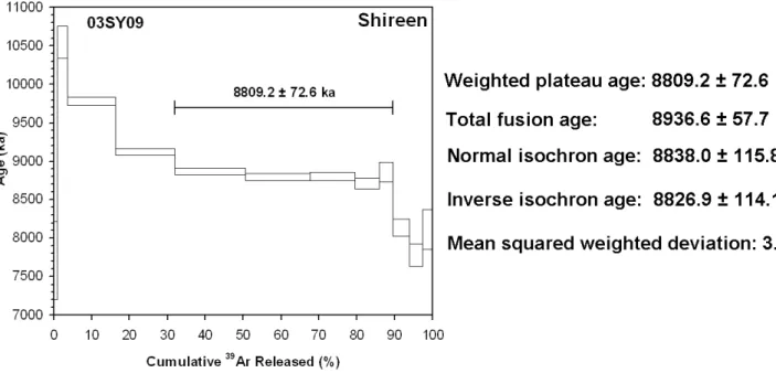
Ar-Ar dating gave an age of 8809±73 ka (±2σ ) for our sam-ple (Fig. 5). It is thus Late Miocene, therefore much older than the “Early Pleistocene” age, shown on the local geo-logical map sheet. Thius younger age seems to have been inferred (Ponikarov et al., 1967) by analogy with the Pleis-tocene basalts in the nearby Karasu Valley (cf. Yurtmen et al., 2002; Seyrek et al., 2007). However, the degree of weather-ing is more characteristic of the Late Miocene Homs basalt of western Syria (∼6 Ma; Mouty et al., 1992) and Karac¸ay basalt of SW Turkey (∼7 Ma; Westaway et al., 2005b).
Our new date also fits the existing dating framework for the Yavuzeli Basalt in adjacent parts of Turkey. For instance, Ulu (1996a) mentioned a K-Ar date of 10.6±0.2 Ma for one of the Yavuzeli Basalt flow units east of Birecik (Fig. 1); Ter-lemez et al. (1997) cited an unpublished oil-industry report in support of dating this phase of volcanism to ∼9–8 Ma. Our new date lies within the range of these earlier estimates. Farther northeast, the voluminous Siverek Volcanics, which crop out widely between Diyarbakır and the River Euphrates (Fig. 1) have an age of 7.8±1.7 Ma (±2σ ), determined as the weighted mean of three K-Ar dates (Bridgland et al., 2007), making them also broadly synchronous with the Shireen vol-canism.
5 Late Miocene location of the Euphrates
Although exposure and preservation are not ideal, we inter-pret the gravel in Figs. 2b, c as fluvial. Since chert is rel-atively rare in the Cenozoic carbonate sequence of the Ara-bian Platform, we consider it probable that the abundant chert clasts originated from the ophiolite suite at the Neotethys suture, ∼200 km farther north (Fig. 1). The unidentifiable weathered clasts may thus be of igneous constituents from this ophiolite. The gravel thus indicates the presence of the ancestral River Euphrates in this area at ∼9 Ma.
The disposition of the basalt and gravel indicates that the former cascaded into the Euphrates valley from the south, the evidence (Fig. 4b) suggesting that it reached beyond the ter-race bluff of what was at this time a low terter-race on the north
a result of the basalt-damming of its valley. This eastward course most likely led towards Raqqa, shown schematically as course 2 in Fig. 1. NW of Raqqa, a succession of fluvial sands and gravels, locally >10 m thick (base not exposed), attributed to the Euphrates from their polymict lithology (Ta-ble 2), crops out over an area of ∼200 km2(Fig. 1) at up to
∼320 m a.s.l., ∼80 m above the modern river. These gravels
adjoin the western end of the outcrop of Upper Fars Forma-tion (Fig. 1), but like the basalt were inferred in the 1960s mapping to be “Early Pleistocene” (Ponikarov, 1966). These deposits appear much less weathered than those at Shireen, but the Raqqa area has much less annual rainfall (<200 mm, against ∼350 mm) and the Pleistocene Euphrates terraces have locally experienced minimal weathering, in contrast with farther NW. We thus suggest that these Raqqa gravels mark the downstream limit of the SE course of the Euphrates through Shireen, recorded by the gravel there, and also delin-eate the paleocoastline adjoining the contemporaneous Late Miocene depocentre of the Upper Fars Formation. Subse-quently, due to continuing regional uplift, the sea retreated from this area and the Euphrates thus extended downstream across eastern Syria and Iraq (3, Fig. 1).
Previous studies (e.g., Brew et al., 1997; Besanc¸on and Geyer, 2003) have noted that the SE-trending course of the Euphrates below Raqqa is structurally controlled, by local downwarping along the Euphrates Fault Zone. We thus sug-gest that in the Late Miocene, the reach of the ancestral Eu-phrates between Shireen and Raqqa was also controlled by the same lineation (Fault F1 in Fig. 2). We infer that, at a later stage, processes in the Shireen area (including local faulting and folding, the latter including NW downthrow on fault F2; differential erosion; southward tilting) disrupted this course and deflected the river to form its modern looped course up-stream of Raqqa, which is now flooded by the Lake Assad reservoir (Fig. 1).
6 Post-Miocene uplift and fluvial incision
Regarding the incision history, we note that in SE Turkey the +60 m Euphrates terrace (QfIII) has been thought to date from MIS 12 and, it seems, the volumetrically most sig-nificant gravel (of terrace QfV, reaching +110 m) has been thought to have finished aggrading in MIS 22 (Sanlaville,
32 T. Demir et al.: Late Miocene River Euphrates
Fig. 5. Main part of figure shows an age spectrum derived from step-heating of sample 03SY09. The horizontal bar indicates the heating
steps used to calculate the age estimate from step-heating. To the right are listed four age determinations for the same sample based on different analysis methods; the internal consistency of these different numerical ages and their low error margins demonstrate the reliability of this date (see Demir et al., 2007, for more details). Following previous recommendations (e.g., Harford et al., 2002), the calculation based on step-heating is considered definitive. Calibration of the neutron flux during sample irradiation utililised the U.S. Geological Survey Taylor Creek Rhyolite sanidine standard TCR-2A with an assigned age of 28.34 Ma (after Renne et al., 1998). The material dated was groundmass, after magnetic separation, prepared following the procedure used previously by Yurtmen et al. (2002) and Westaway et al. (2004, 2005b, 2006b). Analysis was carried out at the Isotope Geosciences Laboratory, Massachusetts Institute of Technology, the method used being essentially the same as that described by Harford et al. (2002). Age calculations have assumed the decay constants of Steiger and J¨ager (1977).
Table 2. Gravel composition near Khuzayma.
Lithology Number % Quartzite 89 36% Chert or flint 55 22% Quartz 33 13% Mafic igneous 32 13% Limestone or marble 18 7% Calcschist 10 4% Hard mudstone 8 3% Sandstone 2 1%
Summary of results of a stone count of 247 clasts in the 16–32 mm size fraction, col-lected from the Euphrates gravel at [DV 98374 96614], to the south of Khuzayma (Fig. 1).
2004; Demir et al., 2004). Taking account of the regional southward tapering in uplift rates (Arger et al., 2000), we suggest that the upper part of the principal Euphrates gravel around Shireen (reaching +70 m, assigned to terrace QfIII; Figs. 2, 3) likewise probably aggraded no later than MIS 22. Other possible correlations of the terrace gravels between the Shireen and Birecik areas and with MIS stages are discussed by Demir et al. (2007). The minimal net incision at Shireen,
estimated between ∼8.8 Ma and ∼0.9 Ma, is attributed in part to the local downwarping caused by slip on fault F2 (Fig. 2) and in part to the dramatic downstream lengthen-ing of the Euphrates channel that accompanied the coastal retreat (Fig. 1). The ∼45 m thickness of the QfIII terrace gravel (Fig. 3) indicates that the Euphrates did not remain at a constant level (relative to the bedrock geology in the Shireen area) during this span of time; it evidently incised to within
∼25 m of its present level before aggrading back to ∼70 m
above its present level, before re-incising (during the Middle and Late Pleistocene, given our preferred set of terrace ages) to its present level.
Fault F2 in Fig. 2 is presumed (like many others in the northern Arabian Platform; e.g., Chaimov et al., 1990; Brew et al., 1997; Litak et al., 1997; Cos¸kun and Cos¸kun, 2000) to have been active at some stage between the Late Miocene and Middle Pliocene; it can be seen in Fig. 2 to have offset and warped the local Miocene and older stratigraphy. On the upthrown side of the fault the Eu-phrates has incised into Eocene limestone, whereas on the downthrown side it has only reached the stratigraphically overlying Oligocene limestone. Using the geological map and the additional topographic information in the on-line supplement (http://www.electronic-earth.net/2/27/2007/
gradient between this point and the coastline was probably very low, and so its change in height between these points can be neglected in this approximate calculation. If any subse-quent global sea-level fall is also neglected, some ∼470 m of uplift can thus be estimated at Shireen since ∼9 Ma, from the
∼370 m a.s.l. present-day altitude of the the Shireen gravel
plus the ∼+100 m correction for subsequent local structural warping. For comparison, west of Shireen, Early Miocene marine limestone and Middle Miocene marine clastics are both found at up to ∼500 m a.s.l. (Fig. 2), and would prob-ably be somewhat higher if the localised warping in the Shireen area had not occurred. Their disposition is con-sistent with the calculation using the Shireen gravel; thus,
∼470 m seems a reasonable estimate for the regional uplift
in the Shireen area since ∼9 Ma, greatly in excess of the observed fluvial incision, due to the effect of downstream channel-lengthening.
7 Conclusions
The discovery of Euphrates gravel, capped and preserved by basalt, dated to ∼9 Ma, constrains the evolution of the River Euphrates in northern Syria during the Late Miocene. In the early Middle Miocene, the ancestral Euphrates reached the sea near Kahramanmaras¸ in southern Turkey (1, Fig. 1). Re-gional uplift in the Late Miocene caused the coast to retreat south and east, and the river thus lengthened downstream to the vicinity of Raqqa in northern Syria (2, Fig. 1). Continu-ing regional uplift in the Pliocene caused the coast to retreat farther southeast, and the river extended to the eastern margin of the modern Arabian Platform uplands (3, Fig. 1).
Acknowledgements. Supported by the Council for British Research
in the Levant (D. Bridgland) and by Harran University Scientific Research Council (T. Demir). W. Olszewski helped with docu-mentation of the Ar-Ar dating results. We thank J. Vandenberge and an anonymous reviewer for their thoughtful and constructive comments. This study contributes to IGCP 518 “Fluvial sequences as evidence for landscape and climatic evolution in the Late Cenozoic”. Full documentation of the Ar-Ar dating and land surface imagery of the study region is provided in the online supplement.
Edited by: J. Smit
N´eolithique a l’avenement de l’Islam., edited by: Geyer, B. and Montchambert, J.-Y., vol. 1. Institut Franc¸ais du Proche Orient, Beirut, Lebanon, 7–59, 2003.
Brew, G., Litak, R., Seber, D., Barazangi, M., Sawak, T., and Al-Iman, A.: Basement depth and sedimentary velocity structure in the northern Arabian Platform, eastern Syria, Geophys. J. Int., 128, 617–631, 1997.
Bridgland, D., Demir, T., Seyrek, A., Pringle, M., Westaway, R., Beck, A., Yurtmen, S., and Rowbotham, G.: Dating Quater-nary volcanism and incision by the River Tigris at Diyarbakır, SE Turkey, J. Quat. Sci., 22, 387–393, 2007.
Bridgland, D., Philip, G., Westaway, R., and White, M.: A long Quaternary terrace sequence in the valley of the River Orontes, near Homs, Syria, Current Science, 84, 1080–1089, 2003. Chaimov, T., Barazangi, M., Al-Saad, D., Sawaf, T., and Gebran,
A.: Crustal shortening in the Palmyride fold belt, Syria, and im-plications for movement along the Dead Sea fault system, Tec-tonics, 9, 1369–1386, 1990.
Cos¸kun, B. and Cos¸kun, S.: The Dead Sea Fault and related subsur-face structures, Gaziantep Basin, SE Turkey, Geological Maga-zine, 137, 175–192, 2000.
Demir, T., Pringle, M., Yurtmen, S., Westaway, R., Bridgland, D., Beck, A., Challis, K., and Rowbotham, G.: Reply to interac-tive comment by J. Vandenberghe on “Location of the River Eu-phrates in the Late Miocene; dating of terrace gravel at Shireen, Syria”, by Demir, T., Pringle, M., Yurtmen, S., Westaway, R., Bridgland, D., Beck, A., Challis, K., and Rowbotham, G., eEarth Discuss., 1, 13 pp (published online), 2007.
Demir, T., Yes¸ilnacar, ˙I., and Westaway, R.: River terrace sequences in Turkey: sources of evidence for lateral variations in regional uplift, Proceedings of the Geologists’ Association, 115, 289– 311, 2004.
Derman, A.: Braided river deposits related to progressive Miocene surface uplift in Kahraman Maras¸ area, SE Turkey, Geological Journal, 34, 159–174, 1999.
Garfunkel, Z.: Internal structure of the Dead Sea leaky transform (rift) in relation to plate kinematics, Tectonophysics, 80, 81–108, 1981.
Gomez, F., Khawlie, M., Tabet, C., Darkal, A. N., Khair, K., and Barazangi, M.: Late Cenozoic uplift along the northern Dead Sea transform in Syria and Lebanon, Earth Planet. Sci. Lett., 241, 913–931, 2006.
Harford, C. L., Pringle, M. S., Sparks, R. S. J., and Young, S. R.: The volcanic evolution of Montserrat using40Ar/39Ar geochronology, in: The eruption of the Soufri`ere Hills volcano, Montserrat, from 1995 to 1999, edited by: Druitt, T. H. and Ko-jkelaar, B. P., Geological Society, London, Memoirs, 21, 93–113, 2002.
34 T. Demir et al.: Late Miocene River Euphrates James, G. and Wynd, J.: Stratigraphic nomenclature of Iranian
Oil Consortium Agreement Area, American Association of Petroleum Geologists’ Bulletin, 49, 2182–2245, 1965.
Karig, D. and Kozlu, H.: Late Palaeogene-Neogene evolution of the triple junction near Maras¸, south-central Turkey, J. Geological Soc., London, 147, 1023–1034, 1990.
Kuzucuoˇglu, C., Fontugne, M., and Mouralis, D.: Holocene terraces in the Middle Euphrates valley between Halfeti and Karkemish (Gaziantep, Turkey), Quaternaire, 15, 195–206, 2004.
Litak, R. K., Barazangi, M., Beauchamp, W., Seber, D., Brew, G., Sawaf, T., and Al-Youssef, W.: Mesozoic-Cenozoic evolution of the intraplate Euphrates fault system, Syria; implications for regional tectonics, J. Geological Soc., London, 154, 653–666, 1997.
Lovelock, P.: A review of the tectonics of the Middle East region, Geological Magazine, 121, 577–587, 1984.
Lucchitta, I.: Late Cenozoic uplift of the SW Colorado Plateau and adjacent lower Colorado River region, Tectonophysics, 61, 63– 95, 1979.
Maddy, D., Demir, T., Bridgland, D., Veldkamp, A., Stemerdink, C., van der Schriek, T., and Westaway, R.: An obliquity-controlled Early Pleistocene river terrace record from western Turkey?, Quat. Res., 63, 339–346, 2005.
Matoshko, A., Gozhik, P., and Danukalova, G.: Key Late Ceno-zoic fluvial archives of eastern Europe: the Dniester, Dnieper, Don and Volga, Proceedings of the Geologists’ Association, 115, 141–173, 2004.
McKee, E. D. and McKee, E. H.: Pliocene uplift of the Grand Canyon region – time of drainage adjustment, Geological Soc. Am. Bull., 83, 1923–1932, 1972.
Mouty, M., Delaloye, M., Fontignie, D., Piskin, O., and Wagner, J.-J.: The volcanic activity in Syria and Lebanon between Jurassic and Actual, Schweizerische Mineralogische und Petrographische Mitteilungen, 72, 91–105, 1992.
Nott, J.: Long-term drainage evolution in the Shoalhaven catch-ment, southeast highlands, Australia, Earth Surface Processes and Landforms, 17, 361–374, 1992.
Oguchi, T.: Geomorphological and environmental settings of Tell Kosak Shamali, Syria, in: Tell Kosak Shamali, the Archaeolog-ical Investigations on the Upper Euphrates, Syria: vol. 1, edited by: Nishiaki, N. and Matsutani, T., Oxbow, Oxford, England, p. 19–40, 2001.
Ponikarov, V.: Geological map of the Jarablus (J-37-III) quadran-gle, 1:200 000 scale, Technoexport, Moscow, and Ministry of In-dustry, Syrian Arab Republic, Damascus, 1966.
Ponikarov, V. P., Kazmin, V. G., Mikhailov, I. A., Razvaliayev, A. V., Krasheninnikov, V. A., Kozlov, V. V., Soulidi-Kondratiyev, E. D., Mikhailov, K. Y., Kulakov, V. V., Faradzhev, V. A., and Mirzayev, K. M.: The Geology of Syria: Explanatory notes on the geological map of Syria, scale 1:500,000. Part I: Stratigra-phy, Igneous Rocks, and Tectonics, Technoexport, Moscow, and Ministry of Industry, Syrian Arab Republic, Damascus, 1967. Renne, P. R., Swisher, C. C., Deino, A. L., Karner, D. B., Owens,
T. L., and DePaolo, D. J.: Intercalibration of standards, absolute ages and uncertainties in40Ar/39Ar dating, Chemical Geology 145, 117–152, 1998.
Rigo de Righi, M. and Cortesini, A.: Gravity tectonics in Foothills Structure Belt of southeast Turkey, American Association of Petroleum Geologists’ Bulletin, 48, 1911–1937, 1964.
Sanlaville, P.: Les terraces Pl´eistoc`enes de la vall´ee de l’Euphrate en Syrie et dans l’extrˆeme sud de la Turquie, British Archaeological Reports, Int. Ser., 1263, 115–133, 2004.
Seyrek, A., Demir, T., Pringle, M., Yurtmen, S., Westaway, R., Beck, A., and Rowbotham, G.: Kinematics of the Amanos Fault, southern Turkey, from Ar-Ar dating of offset Pleistocene basalt flows: transpression between the African and Arabian plates, in: Tectonics of Strike-Slip Restraining and Releasing Bends, edited by: Cunningham, D. and Mann, P., Geological Society, London, Special Publication, in press, 2007.
Steiger, R. H., and J¨ager, E.: Convention on the use of decay con-stants in geo- and cosmochronology, Earth Planet. Sci. Lett., 36, 359–363, 1977.
Stevenson, A. and Brown, C.: The ancient Murray River system, Bureau of Mineral Resources Journal of Australian Geology and Geophysics, 11, 387–395, 1989.
Terlemez, H.C¸ . ˙I., S¸ent¨urk, K., S¨umengen, M., and Oral, A.: Geo-logical map of the Antakya – L24 quadrangle, 1:100 000 scale, and accompanying 11 page explanatory booklet, General Direc-torate of Mineral Research and Exploration, Ankara, 1997. Tyr´aˇcek, J.: Terraces of the Euphrates River, Sborn´ık geologick´ych
Vˇed, Antropozoikum, 18, 185–202, 1987.
Ulu, ¨U.: Geological map of the Suruc¸ – L25 quadrangle, 1:100 000 scale, and accompanying 9 page explanatory booklet, General Directorate of Mineral Research and Exploration, Ankara, 1996. Westaway, R.: Kinematic consistency between the Dead Sea Fault Zone and the Neogene and Quaternary left-lateral faulting in SE Turkey, Tectonophysics, 391, 203–237, 2004.
Westaway, R., Bridgland, D., Challis, K., and White, M.: A dating framework for the Lower and Middle Palaeolithic in Levantine rivers, Council for British Research in the Levant Newsletter, 31– 33, 2005a.
Westaway, R., Guillou, H., Yurtmen, S., Demir, T., and Rowbotham, G.: Constraints on the timing and regional conditions at the start of the present phase of crustal extension in western Turkey from observations in and around the Denizli region, Geodinam-ica Acta, 18, 209–238, 2005b.
Westaway, R., Demir, T., Seyrek, A. and Beck, A.: Kinematics of active left-lateral faulting in southeast Turkey from offset Pleis-tocene river gorges: improved constraint on the rate and history of relative motion between the Turkish and Arabian plates, J. Geol. Soc., London, 163, 149–164, 2006a.
Westaway, R., Guillou, H., Yurtmen, S., Beck, A., Bridgland, D., Demir, T., Scaillet, S., and Rowbotham, G.: Late Cenozoic up-lift of western Turkey: Improved dating of the Kula Quaternary volcanic field and numerical modelling of the Gediz river terrace staircase, Global and Planetary Change, 51, 131–171, 2006b. Westaway, R., Pringle, M., Yurtmen, S., Demir, T., Bridgland, D.,
Rowbotham, G., and Maddy, D.: Pliocene and Quaternary re-gional uplift in western Turkey: The Gediz river terrace flight and the volcanism at Kula, Tectonophysics, 391, 121–169, 2004. Yurtmen, S., Guillou, H., Westaway, R., Rowbotham, G., and Tatar, O.: Rate of strike-slip motion on the Amanos Fault (Karasu Val-ley, southern Turkey) constrained by K-Ar dating and geochem-ical analysis of Quaternary basalts, Tectonophysics, 344, 207– 246, 2002.