HAL Id: insu-01892450
https://hal-insu.archives-ouvertes.fr/insu-01892450
Submitted on 10 Oct 2018
HAL is a multi-disciplinary open access
archive for the deposit and dissemination of
sci-entific research documents, whether they are
pub-lished or not. The documents may come from
teaching and research institutions in France or
abroad, or from public or private research centers.
L’archive ouverte pluridisciplinaire HAL, est
destinée au dépôt et à la diffusion de documents
scientifiques de niveau recherche, publiés ou non,
émanant des établissements d’enseignement et de
recherche français ou étrangers, des laboratoires
publics ou privés.
Discovery of a large 2.4 Ma Plinian eruption of
Basse-Terre, Guadeloupe, from the marine sediment
record
Martin Palmer, Stuart Hatter, Thomas Gernon, Rex Taylor, Michael Cassidy,
Peter Johnson, Anne Le Friant, Osamu Ishizuka
To cite this version:
Martin Palmer, Stuart Hatter, Thomas Gernon, Rex Taylor, Michael Cassidy, et al.. Discovery of a
large 2.4 Ma Plinian eruption of Basse-Terre, Guadeloupe, from the marine sediment record. Geology,
Geological Society of America, 2016, 44 (2), pp.123 - 126. �10.1130/g37193.1�. �insu-01892450�
Discovery of a large 2.4 Ma Plinian eruption of Basse-Terre,
Guadeloupe, from the marine sediment record
Martin R. Palmer
1, Stuart J. Hatter
1, Thomas M. Gernon
1, Rex N. Taylor
1, Michael Cassidy
2, Peter Johnson
1,
Anne Le Friant
3, and Osamu Ishizuka
41School of Ocean and Earth Science, University of Southampton, European Way, Southampton SO14 3ZH, UK 2Institute for Geosciences, Johannes Gutenberg University Mainz, J.-J.-Becher-Weg 21, D-55128 Mainz, Germany 3Institut de Physique du Globe de Paris, UMR 7154, CNRS, Paris, France
4Institute of Geology and Geoinformation, Geological Survey of Japan, AIST, Central 7, 1-1-1, Higashi, Ibaraki, Tsukuba 305-8567, Japan
ABSTRACT
Large volcanic eruptions are major geo-hazards, so identifying their frequency in the geologic record is critical for making predictions and hazard assessments. Follow-ing the discovery of a thick (18 cm) tephra layer in marine sediments from Integrated Ocean Drilling Program (IODP) Site U1396 between Montserrat and Guadeloupe in the Caribbean Sea, we document here how high-precision Pb isotopes, trace elements, and grain morphological analyses of the tephra can be used, together with volcanological models, to identify a large (Volcanic Explo-sivity Index ~6) Plinian eruption from Basse-Terre, Guadeloupe, at ca. 2.36 Ma. This pre-viously unrecognized eruption is believed to be the largest documented volcanic event in this region since this time. We hypothesize that this large eruption was associated with the final stage in the evolution of an individ-ual volcanic center, which has implications for prediction of geohazards in this setting. INTRODUCTION
Reconstructing the history of island arc vol-canoes is critical for determining their petro-logical evolution and potential geohazards, but such studies are difficult because erosion and later eruptions destroy and obscure the subaerial record of volcanoes, with much of the erupted material rapidly transported to the oceans (Le Friant et al., 2015). While marine sediment cores can provide more complete histories of arc volcanism, this approach requires identification of the depositional mode of marine tephra layers and their precise origin from closely spaced and compositionally similar volcanoes.
This problem is exemplified in the Lesser Antilles, Caribbean Sea, where volcanism has been active since ca. 40 Ma. To the north of Martinique, the arc is divided into two chains. The eastern, inactive chain is older, with carbon-ate platforms covering volcanic basement. Tec-tonic adjustments during the Miocene modified the orientation of the subducting slab, causing westward migration of the volcanic front and initiation of a new arc that includes all the ac-tive volcanoes (Pindell and Barrett, 1990). In order to reconstruct a long-term record of
volca-nism in the northern Lesser Antilles, Integrated Ocean Drilling Program (IODP) Expedition 340 occupied four sites in A.D. 2012 offshore the currently active island of Montserrat. Site U1396 is located on a topographic high (water depth of ~780 m), ~30 km southwest of Mont-serrat and ~75 km west of Guadeloupe (Fig. 1). Of the three holes cored at the site with the ad-vanced piston corer, two produced continuous (Hole U1396A, 140.5 m; Hole U1396C, 145.9 m) records that extend back ~4.5 m.y. (Hatfield, 2015). The sediments comprise hemipelagic (largely carbonate) sediment and volcaniclastic mud, with more than 150 visible (>0.5 cm thick) tephra layers intercalated in hemipelagic back-ground sediments (Le Friant et al., 2015). The present study uses geochemical, grain morphol-ogy, and volcanological techniques to identify the origin and magnitude of the eruption that generated the thickest tephra layer from Site U1396.
SEDIMENT CORE OBSERVATIONS
Tephra was likely delivered to Site U1396 from different sources, but prevailing wind di-rections and seafloor topography suggest, how-ever, that these layers were predominantly from volcanoes on Montserrat and Guadeloupe. The erupted material on both islands consists mainly of andesites, with lesser amounts of basalts and basaltic andesites (Harford et al., 2002; Samper
et al., 2007), but there is a clear north-south gra-dation in the Pb isotope ratio of volcanic rocks in the Lesser Antilles that has been present for ~5 m.y. (Lindsay et al., 2005; Labanieh et al., 2010), and Pb isotope analyses of Montserrat (Cassidy et al., 2012) and Guadeloupe lavas (White and Dupré, 1986) show that the two cen-ters are distinguishable (Fig. 2A; see the GSA Data Repository1). The one Dominican Pb iso-tope datum that lies in the Guadeloupe field is from the <40 ka Morne Anglais center (Lindsay et al., 2005). Of 29 samples of visible tephras analyzed from Site U1396 and shown in Figure 1, 17 fall in the Montserrat Pb isotope field and 12 in the Guadeloupe field. Of the latter, five come from an ~18-cm-thick tephra layer (sub-cores 6H4-U1396A and 6H2-U1396C). The other samples with a Guadeloupe origin come from tephra layers <5 cm thick.
The sedimentary interval of the tephra layer (Fig. 1) is bracketed by the base of the C2r.1n (B) Reunion polarity zone (2.148 Ma) and the base of the C2r.2r (B) Gauss/Matuyama polar-ity zone (2.581 Ma) (Hatfield, 2015) and has an
1 GSA Data Repository item 2016031, T 2.36 geo-chemical data tables, figure of tephra grain morpho-logical characteristics, and age assignment details, is available online at www.geosociety.org/pubs/ft2016 .htm, or on request from editing@geosociety.org or Documents Secretary, GSA, P.O. Box 9140, Boulder, CO 80301, USA. | | | Antigua
Atlantic
Ocean
Outer arc
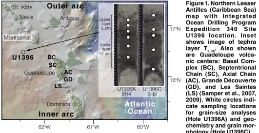
Inner arc
Guadeloupe Nevis St. Kitts Dominica Montserrat U1396 60oW 61oW 62oW U1396A 6H4 U1396C 6H2 lower layer 12 cm upper layer 6 cm BC SC AC LSGD 17oN 16oNFigure 1. Northern Lesser Antilles (Caribbean Sea) map with Integrated Ocean Drilling Program Expedition 340 Site U1396 location. Inset shows image of tephra
layer T2.36. Also shown
are Guadeloupe volca-nic centers: Basal Com-plex (BC), Septentrional Chain (SC), Axial Chain (AC), Grande Découverte (GD), and Les Saintes (LS) (Samper et al., 2007, 2009). White circles indi-cate sampling locations for grain-size analyses (Hole U1396A) and geo-chemistry and grain mor-phology (Hole U1396C).
124 www.gsapubs.org
|
Volume 44|
Number 2|
GEOLOGYinterpolated depositional age of 2.36 Ma (see the Data Repository). Hence, this tephra layer is referred to hereafter as T2.36.
A detailed study of tephra deposits from the current phase of Montserrat activity provides clear objective grain size and morphology pa-rameters for distinguishing fallout and flow de-posits (Cassidy et al., 2014). Five samples taken from different horizons within T2.36 (Fig. 1) were measured for sorting index, angularity, and elon-gation (see the Data Repository). The samples show a range in these parameters, but except for the lowermost sample (6H2 94/95), they all fall within the primary tephra fallout field (Fig. DR1 in the Data Repository). In addition, flow deposits generally exhibit cross-bedding and/or erosive bases (Cassidy et al., 2014); neither fea-ture was identified in T2.36.
COMPARISON WITH THE SUBAERIAL RECORD
Basse-Terre forms the western half of Gua-deloupe, and comprises four major volcanic massifs: the Basal Complex (2.79–2.68 Ma), the Septentrional Chain (1.81–1.15 Ma), the
Axial Chain (1.02–0.44 Ma) and the Grande Découverte volcanic complex (314 ka to pres-ent) (Samper et al., 2007, 2009) (Fig. 1). K-Ar ages show a north-south migration of volcanic activity, with a relatively large age gap between the youngest dates for the Basal Complex (2.68 ± 0.04 Ma) and the oldest age for the Septentri-onal Chain (1.81 ± 0.03 Ma). In addition, there are K-Ar dates for the two volcanic islands— Les Saintes (Terre-de-Bas, 0.92–0.88 Ma; and Terre-de-Haut, 2.98–2.00 Ma)—that lie ~10 km south of Basse-Terre (Zami et al., 2014).
The latitude of the source of T2.36 is uncer-tain, but is likely south of the older Basal Com-plex (~16°19′N). The depositional age of T2.36 lies within the age range of activity on Terre-de-Haut, but the La/Sm ratio of samples from T2.36 fall on the Basse-Terre trend that is distinct from that of Terre-de-Haut lavas (Fig. 2B). Hence geochemical and age data suggest that T2.36 likely derived from Basse-Terre, with equivalent deposits of this source now buried beneath the Septentrional and Axial Chain centers.
The five sampled layers from T2.36 have MgO and SiO2 concentrations that range from 1.12 to 2.75 wt% and 59.4 to 64.6 wt%, respectively (see the Data Repository for methods), which are typical of andesites from Basse-Terre (Sam-per et al., 2007, 2009).
ERUPTION RECONSTRUCTION
It is difficult to unequivocally determine whether more than one eruption was responsible for deposition of T2.36. Hemipelagic sedimenta-tion rates of ~2.8 cm k.y.-1 make sub-centennial gaps between eruptions difficult to identify. Het-erogeneous grain-size distribution, morphology, and geochemistry are also observed in single large deposits (Wiesner et al., 2004), so cannot easily be used to address this problem, but visual inspection of T2.36 indicates that it is composed of an upper layer of ~6 cm and a lower layer of ~12 cm thickness (Fig. 1). Grain-size analyses of the upper and lower layers in the core from Hole U1396A (see the Data Repository) show that the lower layer is coarser grained while the upper layer contains a higher percentage of fine-grained particles (Fig. 3). This pattern is similar to that observed in andesitic fallout deposits (coarser grained) overlain by finer-grained co-pyroclastic/co-ignimbrite flow cloud deposits from the A.D. 2004–2006 eruptions of Colima, Mexico (Evans et al., 2009) and in both subaerial and marine tephra deposits of the Campanian ig-nimbrite (Engwell et al., 2014), and suggest that T2.36 comprises the products of a Plinian eruption (lower layer) and associated lofted co-pyroclas-tic/co-ignimbrite flow deposits (upper layer).
Today, the wind direction over Guadeloupe is exclusively east to west at altitudes >17.5 km and <5 km, and exclusively west to east between ~9 km and 15 km. Just beneath the tropopause (~16.5 km) and between ~5 km and 8.5 km, the
wind direction reverses from east to west in the wet season, to west to east in the dry season (Ko-morowski et al., 2008). Stratospheric circulation at this latitude is controlled by Brewer-Dobson circulation (Andrews et al., 1987), so there is no
a priori reason to expect that stratospheric wind
directions would have been different at 2.36 Ma. It would be preferable to have multiple sites to produce an isopach map to constrain the erup-tion parameters, but this is not possible in this instance. Nevertheless, González-Mellado and De la Cruz-Reyna (2010) used tephra distribu-tions from 14 erupdistribu-tions to propose and calibrate a model relating the tephra thickness (T, cm) at a single site to the eruption column height (H, km), wind speed (U, km hr-1), eruption duration (t, hr), distance from the eruption site (r, km), angle to the main axis of deposition (q, degrees), and tephra density (r, kg m-3):
T r, 14.28 H r 2D e U r 4 /2 1 /2 2D 1 cos ( )θ = τ ρ ( ) ( ) ( ) α −α − − θ −α, (1) where D and a are empirical constants given by
D=52.822 – 770.17 forH
(
H>15 km or)
D=–4.189H+114.407 for(
H<15 km)
D=52.822 – 770.17 forH
(
H>15 km or)
D=–4.189H+114.407 for(
H<15 km)
, (2) andα =2.525 – 0.051H. (3) The thicknesses of the T2.36 layers are 12 cm and 6 cm, r is ~80 km (Fig. 1), and the av-erage r is measured as 1100 kg m-3. We first consider the case of the lower T2.36 layer being
16 12 8 4 18.8 19.0 19.2 19.4 Montserrat Guadeloupe Dominica U1396 T2.36
∆7/
4
206Pb/
204Pb
A
(La/Sm
)
N 3 2 1 1 2 3Age (Ma)
Terre-de-Haut Basal Complex Septentrional T2.36B
40
30
20
10
0
40
30
20
10
0
-0.5 1.5 3.5 5.5 7.5 9.5Fraction of particles in sample (%
)
Bin size φ
Upper
Layer
Lower
Layer
-0.5 1.5 3.5 5.5 7.5 9.5 77/78 79/80 81/82 83/84 86/87 90/91Figure 2. Pb isotope and geochemistry data of tephra and volcanic samples, northern Lesser Antilles. A: D7/4 (relative to
North-ern Hemisphere reference line; Hart, 1984) versus 206Pb/204Pb. Pb isotope data are for
islands from Dominica (Lindsay et al., 2005), Montserrat (Cassidy et al., 2012), and Gua-deloupe (White and Dupré, 1986; C. Chauvel, 2015, personal commun.). Green symbols are for Integrated Ocean Drilling Program Site U1396, and red symbols are for tephra
T2.36. B: Chondrite-normalized La/Sm
ver-sus age for T2.36 and lavas from Guadeloupe (Samper et al., 2007; Zami et al., 2014).
Figure 3. Grain-size analyses of tephra samples from Integrated Ocean Drilling Pro-gram Hole U1396A, northern Lesser Antilles (77/78, etc., refer to depth intervals [in cm] shown in Fig. 1).
Downloaded from https://pubs.geoscienceworld.org/gsa/geology/article-pdf/44/2/123/3549285/123.pdf by CNRS_INSU user
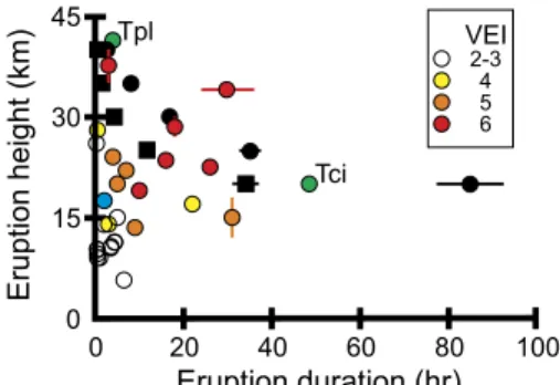
derived from a Plinian (stratospheric) eruption. Present-day stratospheric U values range from 32 to 48 km hr-1 for the dry and wet season, respectively (Komorowski et al., 2008). The stratospheric wind direction is from 90°, and Site U1396 lies on a bearing of ~290° from the Septentrional Chain (Fig. 1) (q = 20°). If these parameters are fixed, it is possible to calculate values of H (eruption column height) and for a given value of t (eruption duration). The results of this calculation are illustrated in Figure 4 for the 12-cm-thick tephra layer at Site U1396, to-gether with observed values and Volcanic Ex-plosivity Index (VEI) of 27 andesitic and silicic eruptions (Mastin et al., 2009). While there is only one site for reconstructing the T2.36 erup-tion parameters, marine tephra deposits from the Campanian ignimbrite deposit have been shown to yield a more regular pattern of expo-nential thinning from the source than their sub-aerial counterparts (Engwell et al., 2014). The main uncertainties in the model concern values of U and q. For example, if q = 0° (i.e., U1396 lay directly under the main axis of deposition), the calculated values of t are ~25% lower for a given value of H, whereas t increases by a fac-tor of ~2–3 if q is increased to 40° (an eruption from the southern tip of Les Saintes). Similarly, if U is reduced to 12.5 km hr-1 (half the mini-mum present-day stratospheric wind velocity; Komorowski et al., 2008), the calculated val-ues of t fall by ~15% for any given value of
H, and if U is increased to 144 km hr-1 (double the maximum present-day stratospheric wind velocity; Komorowski et al., 2008), calculated values of t increase by a factor of ~2.
Calculations for the T2.36 upper layer could be taken to indicate that it was deposited from a smaller Plinian eruption than the lower layer
(Fig. 4), but the lack of hemipelagic sediment between the two layers and the grain-size dis-tributions (Fig. 3) indicate that the upper layer likely represents the co-pyroclastic/co-ignim-brite phase of the same eruption. By compari-son, the Plinian phase of the A.D. 1815 Tam-bora eruption (Indonesia) lasted for 3–4 h and reached a height of 40–43 km, whereas the co-ignimbrite phase lasted for ~2 days and reached 25 km elevation (Kandlbauer and Sparks, 2014) (Fig. 4). Thus, while there are uncertainties in the model, we believe comparison of these cal-culation results with data from modern volca-noes (Mastin et al., 2009) suggests that T2.36 was deposited from an ~VEI 6 Plinian eruption.
By comparison, one of the largest eruptions from the 1995–2012 Montserrat activity was the VEI 3, 20 May 2006 dome collapse (Wadge et al., 2014). There are no reported Holocene eruptions in the Lesser Antilles with a VEI >4 (Venzke, 2013), and the LaMEVE (Large Magnitude Explosive Volcanic Eruptions) da-tabase (Crosweller et al., 2012) lists only two Quaternary Lesser Antilles eruptions with VEI of 6 or greater: those that deposited the ca. 27 ka Grande Savanne Ignimbrite and the ca. 36 ka Roseau Tuff. Recent studies suggest, however, that both of these deposits are made up of a se-ries of smaller eruptions (Howe et al., 2014). Thus, the model calculations presented here (Fig. 4) suggest that the eruption that gener-ated T2.36 was of far greater magnitude than any known eruption in the Lesser Antilles.
It has been suggested that larger eruptions occur during the later stages of the life of a vol-canic center (Caricchi et al., 2014). Thus one hypothesis for the large size of the T2.36 event (compared to typical eruptions in the region) is that it represents the last phase of activity of the Basal Complex, during which development of a thick crust allowed the volcanic system to enter a period of magma storage (cf. Caricchi et al., 2014) that ended with the large T2.36 eruption. Hence, the largest and potentially most hazard-ous eruptions in this setting may be associated with mature volcanic centers that become reac-tivated following a lengthy period of dormancy.
ACKNOWLEDGMENTS
This research used samples provided by the IODP. Funding for this research was provided by Natural Environment Research Council. We are grateful to the scientists and crew of IODP Expedition 340 for their help during the expedition. This manuscript benefitted from reviews by C. Annen, J.C. Komorowski, T. Thor-darson, and three anonymous reviewers.
REFERENCES CITED
Andrews, D.G., Holton, J.R., and Leovy, C.B., 1987, Middle Atmosphere Dynamics: Orlando, Flor-ida, Academic Press, 489 p.
Caricchi, L., Annen, C., Blundy, J., Simpson, G., and Pinel, P., 2014, Frequency and magnitude of volcanic eruptions controlled by magma in-jection and buoyancy: Nature Geoscience, v. 7, p. 126–130, doi:10.1038/ngeo2041.
Cassidy, M., Taylor, R.N., Palmer, M.R., Cooper, R.J., Stenlake, C., and Trofimovs, J., 2012, Tracking the magmatic evolution of island arc volcanism: Insights from a high-precision Pb isotope record of Montserrat, Lesser Antilles: Geochemistry Geophysics Geosystems, v. 13, Q05003, doi:10.1029/2012GC004064. Cassidy, M., Watt, S.F.L., Palmer, M.R., Trofimovs,
J., Symons, W., Maclachlan, S.E., and Stinton, A.J., 2014, Construction of volcanic records from marine sediment cores: A review and case study (Montserrat, West Indies): Earth-Science Reviews, v. 138, p. 137–155, doi:10.1016/j .earscirev .2014 .08.008.
Crosweller, H.S., et al., 2012, Global database of large magnitude explosive volcanic eruptions (LaMEVE): Journal of Applied Volcanology, v. 1, 4, doi:10.1186/2191-5040-1-4.
Engwell, S.L., Sparks, R.S.J., and Carey, S., 2014, Physical characteristics of tephra layers in the deep sea realm: The Campanian Ignimbrite eruption, in Austin, W.E.N., et al., eds., Ma-rine Tephrochronology: Geological Society of London Special Publication 398, p. 47–64, doi: 10.1144 /SP398.7.
Evans, J.R., Huntoon, J.E., Rose, W.I., Varley, N.R., and Stevenson, J.A., 2009, Particle sizes of andesitic ash fallout from vertical eruptions and co-pyroclastic flow clouds, Volcán de Co-lima, Mexico: Geology, v. 37, p. 935–938, doi: 10.1130 /G30208A.1.
González-Mellado, A.O., and De la Cruz-Reyna, S., 2010, A simple-empirical approach to model thickness of ash-deposits for different eruption scenarios: Natural Hazards and Earth System Sciences, v. 10, p. 2241–2257, doi:10.5194 /nhess -10-2241-2010.
Harford, C.L., Pringle, M.S., Sparks, R.S.J., and Young, S.R., 2002, The volcanic evolution of Montserrat using 40Ar/39Ar geochronology, in Druitt, T.H., and Kokelaar, B.P., eds., The Erup-tion of Soufrière Hills Volcano, Montserrat, from 1995 to 1999: Geological Society of Lon-don Memoir 21, p. 93–113, doi:10.1144/GSL .MEM .2002 .021 .01.05.
Hart, S.R., 1984, A large-scale isotope anomaly in the southern-hemisphere mantle: Nature, v. 309, p. 753–757, doi:10.1038/309753a0.
Hatfield, R.G., 2015, Data report: Stratigraphic cor-relation of Site U1396 and creation of a compos-ite depth scale and splice, in Le Friant, A., et al., eds., Proceedings of the Integrated Ocean Drill-ing Program, Volume 340: Tokyo, Integrated Drilling Program Management International, Inc., doi:10.2204/iodp.proc.340.202.2015. Howe, T.M., Lindsay, J.M., Shane, P., Schmitt, A.K.,
and Stockli, D.F., 2014, Re-evaluation of the Roseau Tuff eruptive sequence and other ig-nimbrites in Dominica, Lesser Antilles: Jour-nal of Quaternary Science, v. 29, p. 531–546, doi:10.1002/jqs.2723.
Kandlbauer, J., and Sparks, R.S.J., 2014, New estimates of the 1815 Tambora eruption volume: Journal of Volcanology and Geothermal Research, v. 286, p. 93–100, doi:10.1016/j .jvolgeores .2014 .08.020. Komorowski, J.C., Legendre, Y., Caron, B., and
Boudon, G., 2008, Reconstruction and analysis of sub-plinian tephra dispersal during the 1530 A.D. Soufrière (Guadeloupe) eruption: Implica-tions for scenario definition and hazards assess-ment: Journal of Volcanology and Geothermal Research, v. 178, p. 491–515, doi:10.1016/j .jvolgeores .2007.11.022.
Labanieh, S., Chauvel, C., Germa, A., Quidelleur, X., and Lewin, E., 2010, Isotopic hyperbo-las constrain sources and processes under the Lesser Antilles arc: Earth and Planetary Science 45 30 15 0 0 20 40 60 80 100 Eruption height (km) Eruption duration (hr) Tpl Tci VEI 2-3 4 5 6
Figure 4. Relationship between volcanic eruption height and duration. Black circles and squares are calculated values (Equa-tion 1) for lower and upper por(Equa-tions of tephra T2.36, respectively. Green circles are Tambora Plinian (Tpl) and co-ignimbrite (Tci) erup-tions (Kandlbauer and Sparks, 2014). Blue circle is Montserrat 20 May 2006 eruption (Wadge et al., 2014). All other data points are color coded for Volcanic Explosivity Index (VEI) and are from volcanoes with various height, duration, and VEI, as reported by Mastin et al. (2009, their table 1).
126 www.gsapubs.org
|
Volume 44|
Number 2|
GEOLOGY Letters, v. 298, p. 35–46, doi:10.1016/j .epsl.2010 .07.018.
Le Friant, A., et al., 2015, Submarine record of volca-nic island construction and collapse in the Lesser Antilles arc: First scientific drilling of submarine volcanic island landslides by IODP Expedition 340: Geochemistry Geophysics Geosystems, v. 16, p. 420–442, doi: 10.1002 /2014GC005652. Lindsay, J.M., Trumbull, R.B., and Siebel, W., 2005,
Geochemistry and petrogenesis of late Pleisto-cene to Recent volcanism in Southern Domi-nica, Lesser Antilles: Journal of Volcanology and Geothermal Research, v. 148, p. 253–294, doi: 10.1016 /j .jvolgeores .2005.04.018.
Mastin, L.G., et al., 2009, A multidisciplinary effort to assign realistic source parameters to models of volcanic ash-cloud transport and dispersion during eruptions: Journal of Volcanology and Geothermal Research, v. 186, p. 10–21, doi: 10.1016 /j .jvolgeores .2009 .01.008.
Pindell, J., and Barrett, S., 1990, Geological evolu-tion of the Caribbean region: A plate tectonic perspective, in Dengo, G., and Case, J.E., eds., The Caribbean Region: Boulder, Colorado, Geological Society of America, Geology of North America, v. H, p. 405–432.
Samper, A., Quidelleur, X., Lahitte, P., and Mollex, D., 2007, Timing of effusive volcanism and col-lapse events within an oceanic arc island: Basse-Terre, Guadeloupe archipelago (Lesser Antilles Arc): Earth and Planetary Science Letters, v. 258, p. 175–191, doi:10.1016/j .epsl .2007 .03.030. Samper, A., Quidelleur, X., Komorowski, J.C.,
La-hitte, P., and Boudon, G., 2009, Effusive history of the Grande Découverte Volcanic Complex, southern Basse-Terre (Guadeloupe, French West Indies) from new K-Ar Cassignol-Gillot ages: Journal of Volcanology and Geothermal Research, v. 187, p. 117–130, doi:10.1016/j .jvolgeores .2009 .08.016.
Venzke, E., ed., 2013, Volcanoes of the world, ver-sion 4.4.1: Washington, D.C., Smithsonian Insti-tution, Global Volcanism Program, doi:10.5479 /si .GVP .VOTW4-2013.
Wadge, G., Voight, B., Sparks, R.S.J., Cole, P.D., Loughlin, S.C., and Robertson, R.E.A., 2014, An overview of the eruption of Soufrière Hills Volcano, Montserrat from 2000 to 2010, in Wadge, G., et al., eds., The Eruption of Sou-frière Hills Volcano, Montserrat from 2000 to 2010: Geological Society of London Memoir 39, p. 1–39, doi:10.1144/M39.1.
White, W.M., and Dupré, B., 1986, Sediment subduc-tion and magma genesis in the Lesser Antilles: Isotopic and trace element constraints: Journal of Geophysical Research, v. 91, p. 5927–5941, doi: 10.1029 /JB091iB06p05927.
Wiesner, M.G., Wetzel, A., Catane, S.G., Listanco, E.L., and Mirabueno, H.T., 2004, Grain size, ar-eal thickness distribution and controls on sedi-mentation of the 1991 Mount Pinatubo tephra layer in the South China Sea: Bulletin of Volca-nology, v. 66, p. 226–242, doi:10.1007/s00445 -003 -0306-x.
Zami, F., Quidelleur, X., Ricci, J., Lebrun, J.F., and Samper, A., 2014, Initial sub-aerial volcanic ac-tivity along the central Lesser Antilles inner arc: New K–Ar ages from Les Saintes volcanoes: Journal of Volcanology and Geothermal Re-search, v. 287, p. 12–21, doi:10.1016/j .jvolgeores .2014 .09.011.
Manuscript received 24 July 2015
Revised manuscript received 4 December 2015 Manuscript accepted 7 December 2015 Printed in USA
Downloaded from https://pubs.geoscienceworld.org/gsa/geology/article-pdf/44/2/123/3549285/123.pdf by CNRS_INSU user
![Figure 3. Grain-size analyses of tephra samples from Integrated Ocean Drilling Pro-gram Hole U1396A, northern Lesser Antilles (77/78, etc., refer to depth intervals [in cm]](https://thumb-eu.123doks.com/thumbv2/123doknet/14713747.568254/3.891.50.301.55.446/figure-analyses-samples-integrated-drilling-northern-antilles-intervals.webp)