The Balance of Local Culture and Global Economic Development: the Case of the Nyarugenge Heritage Village in Kigali, Rwanda
By
Billy Ndengeyingoma B.S. in Civil Engineering Massachusetts Institute of Technology
Cambridge, Massachusetts (2015)
Submitted to the Department of Urban Studies and Planning in partial fulfillment of the requirements for the degree of
Master in City Planning at the
MASSACHUSETTS INSTITUTE OF TECHNOLOGY June 2017
0 2017 Billy Ndengeyingoma. All Rights Reserved
The author hereby grants to MIT the permission to reproduce and to distribute publicly paper and electronic copies of the thesis document in whole or in part in any medium now known or hereafter created.
Signature redacted
Signature redacted
Certified by~ -AsitnPr
DepAssistant fU Department of Ur
Accepted by
Departmen*f1? Studies and Planning Ma 24 017
ofessor Gabriella Carolini ban Studies and Planning
Signature redacted
MASSACHUSETTS INSTITUTE OF TECHNOLOGYJUN 14 2017
LIBRARIES
T
esis Supervisor- sociate Professor P. Christopher Zegras Chair, MCP Committee Department of Urban Studies and Planning
/f
The Balance of Local Culture and Global Economic Development: the Case of the Nyarugenge Heritage Village in Kigali, Rwanda
by
Billy Ndengeyingoma
Submitted to the Department of Urban Studies and Planning on May 24, 2017 in Partial Fulfillment of the Requirements for the Degree of Master in City Planning
Abstract
As the fastest urbanizing continent in the next three decades, Africa is projected to play a major role in the global economy. The upward trend in the influx of foreign direct investments is set to continue thanks to an overall stable political and macroeconomic climate on the continent and microeconomic reforms in many countries. The country of Rwanda stands out
for its reforms to ease business and for its attention to spatial planning as they relate to global competitiveness. The extensive master planning process for its capital Kigali exemplifies the city's aims to integrate its economy in the global market through strategic physical
developments including heritage preservation.
This thesis interrogates the references to and the inclusion of heritage preservation in the planning priorities of a post-colonial, post-conflict and developing city like Kigali aiming to operate as a global city. The plans for the Nyarugenge Heritage Village, currently an active wholesale trading center, will serve as a case study to assess Kigali's intentions to balance its local culture with its participation in the global economy. The case study is discussed through a content analysis of city master plans and interviews with planning stakeholders as well as with store owners in the trading center. The analysis reveals heritage preservation is primarily meant as a tourism attraction and an economic development strategy. In light of this conclusion, the thesis ends on a discussion of a holistic planning process which could achieve a better balance between local culture and global economic development.
Thesis Advisor: Gabriella Carolini, Assistant Professor Reader: Delia Wendel, Lecturer in Landscape Architecture
Acknowledgments
I would first like to express my deepest gratitude to Gabriella Carolini, my thesis advisor, and
to Delia Wendel, my thesis reader, for their support throughout this thesis. Their critical eye, patience and encouragement were critical in shaping the process and the final outcome of my thesis. I am also thankful to have received their advice regarding my future research endeavors, whose results I am looking forward to share with them.
I am grateful for all the individuals who generously shared their perspectives during interviews.
From government officials to shop owners, each interaction added a valuable building block to this thesis. Thank you for allowing me to see my home city of Kigali through your eyes.
I thank the DUSP community for welcoming into the complex and enriching field of urban
studies and planning. I am humbled by your unending compassion and drive to make positive contributions around you, and hope to represent you well in the years to come.
To the MIT-Africa Initiative, I am grateful for your generous sponsorship that immensely contributed to the depth of my thesis.
I end by thanking my family, whose infinite love and support I cannot begin to express in
words. I will simply say to my father, my mother, my older sister and my older brother that we will continue to act as the five fingers on a hand. As I know how much that means to each of you, I hope this thesis can serve as a small testament of the values you have instilled in me.
Contents
I. Introduction ... 5
Context ... Research Q uestions and M ethodology ... 8
II. O verview of K igali M aster Plans ... 10
Conceptual M aster Plan...10
D etailed M aster Plans ... 12
N yarugenge H eritage V illage...15
III. Literature Review ... 18
IV . A nalysis ... 22
Sum m ative Content A nalysis ... 22
H eritage and N yarugenge H eritage V illage ... 25
Heritage and Conservation Plan and Urban Design Objectives ... 25
Insights on motivations and conception of the heritage village project ... 26
Im ageability of N yarugenge H eritage V illage ... 28
H eritage and D evelopm ent Priorities ... 33
Econom ic D evelopm ent...34
Tourism ... 38
H eritage and G uidelines ... 41
Local Identity D evelopm ent Strategy ... 41
Rw andan vernacular architecture and urban design ... 42
City of K igali initiatives to define guidelines ... 43
M inistry of Infrastructure initiatives to define guidelines ... 43
H eritage and Identity ... 46
Identity through heritage and urban design... 46
D istinctiveness: to w hom does identity m atter ... 48
V . Conclusion ... 49
Bibliography...52
I. Introduction
Context
The assertion of Africa being the most rapidly urbanizing continent is widespread and agreed upon, although it has drawn some skepticism. The worldwide urban population first surpassed the rural population in 2009. By 2050, the United Nations estimates the urban population will grow by 2.5 billion people. Ninety percent of this growth, resulting from urbanization and population increase, will occur in Asia and Africa. Africa is projected as the fastest urbanizing continent in the next three
decades. Given the current urbanization rates, the African urban population is set to triple by 2050 and expand the list of megacities with more than 10 million inhabitants. The growth will nonetheless be most significant across existing and rapidly consolidating medium-sized cities with less than a million dwellers (United Nations, 2014). Levels of urbanization also vary across the continent, with
Eastern Africa showing the fastest rates of urbanization (UN-Habitat, 2014).
However, the Africa urbanization narrative has been criticized for its oversimplifications and erroneous claims. Potts (2009) has notably presented country-specific and continent-wide evidence of the slowing and stagnating urbanization rates with some East African regions being the exception. The author urges local planners, academics and international agencies to reframe liberalized
economic policies that currently focus on urban economies, especially given that rural populations will remain predominant in the near future (Potts, 2012). Leading international organizations like the
United Nations insert some concessions about African urbanization in their reports. For instance, the recent UNECA flagship and UN population reports note the low correlation between
urbanization and economic growth ('World Urbanization Prospects', 2014). The failures in implementing normative urban planning approaches from the global North in the global South is
also acknowledged (UN-Habitat, 2014).
At the same time, Africa's appeal to the global economy is difficult to argue against. Although the changes will vary across countries, urbanization rates coupled with population growth will provide Africa with the largest working-age population in the world by 2040 and give rise to middle-class
consumers. The McKinsey Global Institute (2010) therefore urges global companies not to overlook the immense potential of the continent: in 2020, an annual revenue above $2.5 trillion could result from only four types of industries (consumer-facing sectors, resource, agriculture, and
infrastructure). Foreign direct investments have dramatically increased, going from $9 billion in 2000 to $62 billion in 2008 for instance. By 2010, Africa had become the developing region with the highest rate of return on foreign investments. The influx of investments is set to continue thanks to an overall stable political and macroeconomic climate in Africa and to microeconomic reforms in many countries (McKinsey, 2010).
A 2015 report from the World Economic Forum concurs that important strides have been made to reform the business climate in Africa. However, the report notes that African countries have not reached the level of competitiveness expected from two decades of urbanization and growth. In fact,
low levels of competitiveness, extreme poverty and income inequality still plague the continent. Africa is also not following the usual agriculture -manufacturing - service sector progression in economic development. By bypassing the manufacturing phase, the region is heading down a remarkable but highly uncertain development path (World Economic Forum, 2015). According to the World Bank (2017), economic growth in Africa is lagging behind population growth because of spatial factors. The crowded and disconnected urban form in many cities engenders high costs of living and doing business. African cities therefore need efficient spatial development which wiln ensure their entry and competitiveness in the global economy (World Bank, 2017).
When it comes to reforms in promoting and easing of business and attention to spatial planning as they relate to global competitiveness, the country of Rwanda stands out. The annual GDP growth rate ranged between 4.6 and 11.10% in the past decade. During the same time, Rwanda had a
meteoric rise in the World Bank 'Doing Business' index, an aggregate ranking of six factors including ease of starting a business and protection of investors. The country was ranked 158th out of 190 countries in 2007, with Singapore ranked first place ("Doing Business 2007", 2006). Since then, Rwanda has risen to the 56th rank in 2017 and is the second highest ranked Sub-Saharan African nation after Mauritius' ("Doing Business 2017", 2016). On the Global Competitiveness Index, Rwanda received the third highest rank among Sub-Saharan African countries after Mauritius and
South Africa2 ("Global Competitiveness Report", 2016).
These aggregate indices and growth indicators become particularly significant considering Rwanda was torn apart by a genocide in 1994. The country's widely applauded economic turnover is primarily attributed to strategic government interventions, including policies and the creation of institutions. The 'Rwanda Vision 2020', published by the Ministry of Finance and Economic Planning (MINECOFIN) in 2000, set the tone for the country's development goals. Following national reflection sessions, the document puts forth a vision of a strong, modern and united nation with a clear identity. The year 2020 is envisioned as the country should have significantly shifted from its agrarian subsistence-based economy to a knowledge-based economy. This transformation necessitates a strong support of human capital and a liberal trade regime to ensure regional and international integration (Rwanda Vision 2020, 2000). The MINECOFIN has since published two Economic Development and Poverty Reduction Strategies (EDPRS) to detail the implementation route of the 'Rwanda Vision 2020'.
Advances in urban planning have also been observed in Rwanda. The government stands out for its leadership in physical development plans and particularly for its level of involvement in the plans' implementation. According to Goodfellow (2013), the government relies on decentralization to ensure the enforcement of building and environmental regulations. The centerpiece of urban
planning efforts is the capital city of Kigali, as the city's development is expected to pave the way for other cities in Rwanda and attract investments. The ambitious goals for Kigali were set out to be
'The top and second rank were held by New Zealand and Singapore respectively Switzerland and Singapore were the highest ranked countries worldwide.
achieved with consultation from foreign urban planners, particularly from Singapore (Goodfellow, 2013). Several African countries regard Singapore as a model for development, but the Rwanda-Singapore relationship remains remarkable, with Rwanda often dubbed the 'Rwanda-Singapore of Africa'
("Africa's Singapore?", 2012; "Rwanda Aspires to", 201 1).The relationship was first forged on the similarities between Rwanda and Singapore: after facing devastating events, both small and resource-poor geographies headed for new national identities fueled by economic growth strategies reliant on human capital (African Business, 2013).
Rwanda and Singapore most notably collaborated in the master planning process of Kigali. The master planning process was actually first led by the Denver-based design firm OZ Architecture. The firm published the Kigali Conceptual Master Plan in 2007 and followed up in 2010 with Sub-Area Plans for high-priority areas in the city. The master plans from OZ Architecture were complemented by the ones done by Surbana-Jurong (formerly known as Surbana International Consultants), a Singaporean firm behind 90 master plans across 30 countries including 9 in Sub-Saharan Africa. Surbana produced detailed master plans -including urban design, zoning, and transportation guidelines - for the city as whole and for its three districts Nyarugenge, Gasabo, and Kicukiro. This master planning process exemplifies Kigali's economic aims at integrating its economy in the global market through physical development and in particular cemented the Rwanda-Singapore partnership. Divided in five-year development phases, the three detailed district master plans by Surbana are set to guide the transformation of Kigali until 2040. The first phase, spanning between 2013 and 2018, focused on the development of the central business district into an attractive financial hub ('Africa's cities of the future', 2016).
As the end of this phase is nearing, it is timely to review its implications for Kigali thus far and its possible impacts on the city for the years to come. It is interesting to note that the current Rwandan High Commissioner to Singapore -a position created in 2010 - clarified that Rwanda is not calling itself the 'Singapore of Africa' but simply looking at Singapore as a reference in economic
development (African Business, 2016). From this claim, one can wonder what constitutes the limits between emulating an economic model and diluting a national identity in favor of another as implied in a metonymy like the 'Singapore of Africa.' In other words, could the use and the apparent
rejection of that rhetorical device tell us more about Kigali's intentions to balance of its local culture with its participation in the global economy?
This thesis will address those themes through a case study of the aspirational'Nyarugenge Heritage Village' in the Central Business District. The location of this ever-consolidating downtown happens to also be home to one of the oldest neighborhoods in the city. With an urban fabric primarily made of low-rise light industrial and retail uses, the Nyarugenge Detailed District Master Plan depicts the area as a "heritage village" that will preserve the vernacular Rwandan architecture, intimate scale and diversity of facades not found in contemporary architecture. Moreover, the heritage village is
envisioned as an attractive tourist destination with its adaptive reuse of buildings and promotion of local arts and crafts. The urban design guidelines included in the Nyarugenge District master plans
by Surbana aim to create distinctive paths, edges and urban nodes through covered pedestrian walkways, the preservation of certain building facades, and accentuated view corridors to the historic
mosque -the main landmark of the area.
The juxtaposition of a heritage village and a modern CBD has historical, development and spatial implications and sparks debates about desirable urban development in the context of Kigali. The city is a little over a century old and spent half of its existence under colonial rule. After founding Kigali in 1907, the Germans used it as a small administrative and military base. Kigali gained an important administrative role but did not experience significant urban growth under its Belgian rule starting in 1916. The three decades after Rwanda's independence in 1962 were marked by political instabilities which forced people, including Kigali residents, in and out of exile. The city's functions as an urban,
economic and cultural center hardly consolidated in that period (Manikariza, 2015).
Research Questions and Methodology
This thesis will explore how development objectives and planning processes in Kigali balance cultural and economic development goals. The primary aim of the thesis is to understand why cultural heritage preservation is included as a planning priority for the development of Kigali. To do
so, the following sub-questions will be addressed in this thesis: * What are the current development priorities for Kigali?
" How and why have the guiding design and planning principles of Kigali evolved since 2007 initial master planning process to include cultural heritage preservation?
* How do the design elements of the Nyarugenge Heritage Village relate to or contrast with the urban design characteristics of the rest of the CBD?
The first sub-question is primarily answered through an overview of the city's master plans,
discussed in Chapter 2. The following chapter is a literature review that is meant to contextualize the themes and discerned development priorities mentioned in the master plans. These two chapters will provide the basis for a summative content analysis methodology (Weber, 1990; Hsieh & Shannon, 2015). The analysis is performed on a selected set of master plans to address the second sub-question by laying out the contexts in which cultural heritage preservation is expected to operate in Kigali. First, words and phrases which relate to cultural heritage preservation and economic
development were selected based on Chapters 2 and 3. After performing frequency counts using the qualitative data analysis software Nvivo, the contextual usage of those words and phrases was thematically grouped to ease comparisons across master plans. The context is then discussed at length in Chapter 4 to highlight any overt or underlying efforts to balance local culture and global economic development.
Semi-structured interviews of planning stakeholders were conducted to complement the
questions targeted the other two sub-questions depending on the informant's occupation. The majority of respondents are local and national government representatives. The first set of
interviews was conducted with representatives of the One Stop Center (OSC) for the Construction and Urban Planning based in the City of Kigali (CoK). Respondents at the central government level were affiliated with the Ministry of Infrastructure (MININFRA); the Rwanda Development Board (RDB); and the Institute of National Museums of Rwanda (INMR) and the Rwanda Academy for Language and Culture (RALC), both under the Ministry of Sports and Culture (MINISPOC). Except for Anna Breda's interview, all interviews were conducted in Kigali over the month of January 2017.
Respondent Title- Organization
Benon Rukundo Master Planning Zoning Guidelines
Assessment Officer - Kigali One Stop Center (OSC)
Solange Muhirwa Building Construction Architect Officer
-Kigali OSC
Patrick Arinawe * Urban Planner - City of Kigali
* Former member of Surbana master plan consulting team
Antje Ilberg Senior Adviser to the Minister - MININFRA
Adelin Kajangwe Industrial Development Analyst - RDB
Jean de Dieu Mukeshimana Product Development Analyst - RDB
Eric Hakizimana Physical Planner -MININFRA
Anonymous Institute of National Museums of Rwanda
(INMR)
Anonymous RDB
Igor Iradukunda Manager - Century Real Estate
Assumpta Mugiraneza Founder and Director- Iriba Center
Alice Uwimana Public Relations Officer - INMR
Dr. Alphonse Nkurunziza City Engineer - City of Kigali
Merard Mpabwanamuguru Master Plan Review (Development and Doing Business) - OSC
Dr. Jacques Nzabonimpa Director of Culture, Protection and Promotion Unit - Rwanda Academic of Language and Culture (RALC)
Anna Breda Former Senior Architect at the Kigali OSC
A set of structured interviews were conducted with 10 employees or owners of shops located within the boundaries of the future Nyarugenge Heritage Village and along a street proposed to be
pedestrianized. The purpose of these interviews was to assess the urban design character, specifically, the imageability (to be discussed in chapter 2) of the heritage village from the
perspective of the respondents. This assessment adds valuable insights on the third sub-question by including perspectives from individuals who navigate the heritage village and the CBD on a daily basis.
II. Overview of Kigali Master Plans
Conceptual Master Plan
The Kigali Conceptual Master Plan (KCMP) is the first city-wide plan for Rwanda's capital and was prepared for the Rwandan Ministry of Infrastructure. The plan, published in 2007 (the 100th anniversary of the founding of Kigali), was elaborated by a project team lead by OZ Architecture and comprised of EDAW Inc,Tetra Tech Inc, Engineers Without Borders, Worthington Design, and Economics Research Associates. The team of consultants first became involved in Rwanda in 2004 on a few architectural and planning projects. This work involved interactions with the Rwandan President Paul Kagame, the City of Kigali leadership, and the Ministry of Infrastructure. The OZ Architecture team of consultants was offered an opportunity to broaden their planning involvement by preparing a master plan for the City of Kigali. The project team spent over a year studying the context of the city to produce a conceptual plan aimed to provide an overall vision for the development of Kigali over at least five decades (KCMP Chapi, 2007). The KCMP includes five sections: an overview of the planning process; a presentation of the physical, economic, and
institutional context; an assessment of the opportunities and constraints; the plan itself with a categorization in seven new land uses; and suggestions for an implementation strategy and other recommendations.
The intent of the KCMP is to present a flexible framework for long term growth and to provide the groundwork for comprehensive master plans. The framework does not control growth in "an authoritarian way, but [...] is guided by Rwandans as they shape they capital city incrementally." This
will result in a "vibrant, unique, and truly Rwandan city" that meets the basic needs of all its citizens
(KCMP
Introduction, 2007, 9). The timeframe for growth ranges from a few decades to a century as indicated in the two forewords by the then Minister of Infrastructure and Kigali Mayor. The specific goals and objectives of the framework are an explicit reflection of several guiding principles which were agreed upon by the project team and that informed the planning and design process. The principles emphasized among other things holistic planning, capacity building and employment opportunities for Rwandans, and locally based solutions. By following the latter principle, the KCMP "should not import ideas that have worked in other locations or climates unless they arehighly appropriate." Respecting Rwandan culture and avoiding a dependency on international
suppliers can be achieved by using local knowledge and culturally appropriate building technology (KCMP Chap1, 2007, 11).
This guiding principle of locally based solutions appears to work in tandem with the aspirational role of Kigali on the global stage. In his foreword, then Minister Stanislas Kamanzi describes the plan as an aspiration to "celebrate the best parts of the Rwandan history and culture while laying the groundwork for a dazzling future." An integral component of this future involves Kigali availing investment opportunities able to attract investors and visitors from across the world. The former minister envisions Kigali as a model city at the regional, continental, and global scales by the end of the century (KCMP Introduction, 2007, vii). The project team reiterates the vision of Kigali and Rwanda solidifying its position on the global stage both for its development and economic development strategies. For instance, enhancing the security of the city can attract world-class businesses, service investments, and visitors in general. These economic development strategies should not dismiss the existing fabric of the city. In fact, social capital and heritage should be
preserved by encouraging an incremental upgrade of the existing fabric (KCMP Introduction, 2007). With guiding principles and economic development visions as a backdrop, the primary goal of the KCMP is to promote sustainable urban development in Kigali by balancing ecology, equity, and economy. The outcomes of a participatory process with input from city officials, civil society, citizens and other stakeholders form the backbone of this objective (KCMP Chapi, 2007).
Achieving sustainable urbanism -- that is heavily anchored in environmental sustainability -- entails coordinating future land use, transportation and infrastructure with the existing fabric of Kigali and the projected growth of the city. The spatial framework of a sustainable urbanism-minded growth are presented in three maps which are the crux of the KCMP. The Land Use Plan map projects the maximum build out for Kigali by organizing the city into zones of different densities capable of accommodating to population and land area growth. The second map, the Natural Features Plan, illustrates areas where urban development ought to be restricted. These areas include wetlands, open spaces such as natural preserves, and current agricultural zones suitable to remain that way. The Transportation and Infrastructure Plan directly echoes Kigali's vision as regional and continental hub. In fact, the map presents networks that connect proposed economic centers, such as a new International Airport, with existing ones, primarily the city center in Nyarugenge (KCMP Chap4, 2007).
Detailed Master Plans
The KCMP set the groundwork for a comprehensive master planning process that would produce detailed urban design guidelines and propose implementation mechanisms. The OZ Architecture Team, in collaboration with the City of Kigali, produced some comprehensive plans in the form of the Kigali Sub Area Plans published in December 2010. The studies to produce the plans were initiated in 2008 after the team's invitation to Kigali by the then Mayor of Kigali Aisa Kacyira. Four sectors -the administrative boundaries below the district level -were treated as sub areas in these plans: Rebero, Masaka, Kimihurura and Kinyinya. The first two sectors are in the Kicukiro District, the latter two in the Gasabo District. The Sub Area Plans build on the sustainable urbanist goal of the KCMP and present an overall vision for each site that is supplemented by site planning and programning, design and development guidelines, and possible municipal financing tools. Rebero is planned for resort and conference centers related uses that necessitates the preservation of the natural environment and new developments such as hotels. Masaka, the largest of the four sites, is envisioned to include a new city center. Based on its location, the Kimihurura sub area can become a gateway to Kigali from the existing international airport. Finally, Kinyinya can serve as a town center for nearby residential neighborhoods by providing amenities and services suitable for families. To ensure the proper implementation of the Sub Area Plans, the OZ Architecture Team indicated further physical and policy planning was needed. The recommendations included the elaboration of district and city-wide master plans and clear implementation mechanisms (Kigali Sub Area Planning Introduction, 2010).
Earlier in 2010, another set of master plans produced by the Singaporean firm Surbana International Consultants was published. With the aim of following up on the KCMP with comprehensive master plans, the City of Kigali engaged Surbana in 2008 with the development of detailed master plans for the Nyarugenge District, the Central Business District, and a potential residential area in Kinyinya (Damani & Karunakaran, 2010). There is no trace of a standalone Kinyinya plan by Surbana in the online repository3 of master plans. However, master plans for the Nyarugenge district and the CBD were published in February 2010. Surbana continued their involvement in Kigali as the firm was
chosen by the City of Kigali after a public tender to produce detailed master plans for Gasabo and Kicukiro, the two other districts of the city. In May 2013, these master plans were completed and were published along other plans and reports including an integrated Kigali-wide master plan, a
transportation master plan for the city, and urban design reports for one sector in Gasabo and another in Kicukiro. Under the comprehensive master plan umbrella, the three district master plans put worth more detailed urban design guidelines and implementation timelines.
Out of the extensive set of Surbana master plans, the most relevant plans to further discuss in this thesis and in relation to the 'Nyarugenge Heritage Village' case study are the Nyarugenge district and 3 http://www.masterplan2013.kigalicity.gov.rw/Downloads/
the CBD master plans as well as the integrated Kigali master plan. The 2010 Nyarugenge district master plan was presented in three volumes: a detailed master plan, a transportation and
infrastructure master plan, and a zoning and urban design guidelines report. The main of these volumes was to provide a blueprint for the physical development of the district until about 2030. A clear development pathway was necessary for Nyarugenge especially because of the urgency to consolidate and bolster the functions of a CBD (Damani & Karunakaran, 2010, i). The Nyarugenge District is envisioned as "Kigali's Revitalized Central Business District and Vibrant New Growth Area". As stipulated in the district master plan, this vision further materializes the aspirations of "Rwanda's progressive government and enterprising population [...] to position the country as the economic and financial hub of Central Africa" and "Kigali as a global city with a thriving economy, a vibrant social setting and attractive housing options" (Detailed Master Plan Report for Nyarugenge, Vol1, 2010, p.iii). The vision also aligns with the Vision 2020, the EDPRS, and the KCMP. The guiding principles of livability, prosperity and ecological sustainability of this district master plan are said to have been adapted from the sustainable urbanism principles of the KCMP (Detailed Master Plan Report for Nyarugenge, Voll, 2010, p.iii). And to ensure these principles and vision are elaborated in an inclusive manner, the district master planning process included participatory meetings with representatives of the City of Kigali and the general public (Detailed Master Plan Report for Nyarugenge, Voll, 2010, p.i).
The proposed vision of Nyarugenge as a revitalized CBD and vibrant new growth area comes with seven goals with associated objectives and strategies. The seven goals are introduced as follows: "revival of the existing central business district and creation of well distributed district level urban nodes"; "renewal of existing urban areas"; "development of comprehensive new townships"; "creation of alluring recreational features and tourist attractions"; "transit oriented development supported by an efficient and cost-effective transportation system"; "provision of integrated, timely, cost effective and eco-friendly infrastructure facilities"; and "conservation, revitalization and
management of the unique and rich natural features" (Damani & Karunakaran, 2010, 3-3). One of the objectives under the goal of reviving the CBD is to meet the city of Kigali and the East African region's needs in commercial space. Doing so will involve the development of spaces catered to banks, multinational companies and large retail as well as activities complementary these businesses. The activities include entertainment venues, convention spaces, and hotels (Damani & Karunakaran,
2010, p.3-4). The "renewal of existing urban areas" goal involves the conservation and revitalization
of heritage and cultural landmarks. Applying a local "Rwandan" character -the adjective Rwandan is between quotes in the document - to new public projects is listed as a strategy to reach the goal. Another strategy is redeveloping historic market areas while maintaining their character and built form. For example, the Nyabugogo market -- one of the most active areas in the city -- could be turned into "a vibrant cultural market, targeting both tourists and locals" (Damani & Karunakaran, 2010, p.3-5). This type of development could also fulfill the "creation of alluring recreational features and tourist attractions" goal (Damani & Karunakaran, 2010, p.3-7).
With the CBD already a major focus area of the Nyarugenge district, the 2010 detailed master plan for the CBD provides additional levels of vision and specificity. The CBD master planning process was informed by three guiding principles -"economic advancement", "people oriented", and
"ecological sustainability" -which mirror the ones in the Nyarugenge plans (Karunakaran & Damani, 2010, 1-1). In this plan, the CBD of the city of Kigali is envisioned as "[t]he Green Financial Hub of Central Africa" (Karunakaran3-2). The master plan reiterates the crucial of the central business district in bolster Kigali and Rwanda's economic development. In fact, the CBD will need to cater to multinational and local companies and to other activities around conventions and tourism.
"[I]mpart[ing] local character and identity to the CBD" by enhancing heritage areas and public spaces can also contribute to the city's economic development which already has some momentum. In fact, a real estate demand section in the master plan notes that land prices in Kigali had been on the rise but adds that no records in support of that claim were available given the city's young property market.
The CBD will actually be comprised of two CBDs located in the Muhima and the Nyarugenge sectors, two adjacent sectors in the Nyarugenge District. Medium to low-end housing currently make up the bulk of the existing built form in the Muhima sector (Karunakaran & Damani, 2010, 2-3). The area is therefore proposed to be completely redeveloped into the "modern CBD core of Kigali" (Karunakaran & Damani, 2010, iv) -- the Muhima CBD is referred to as the CBD1. The Nyarugenge CBD2 is envisioned as the "historic CBD of Kigali" which will include high-end
modern developments catering to large-scale businesses while retaining the existing historic and low-rise urban fabric (Karunakaran & Damani, 2010, iv). The existing conditions in the Nyarugenge sector, which is already considered Kigali's center and financial hub, reflect the history of the urban growth of the city following Rwanda's independence in 1962. Various developments sprouted in the sector, from civic and educational facilities to housing and an active wholesale market (Karunakaran & Damani, 2010, 2-3). This market still operates as the primary wholesale trading center in Kigali but those are considered incompatible with the consolidation of the CBD2. The wholesale activities should be relocated but the built form of the market preserved and redeveloped for cultural and tourism purposes
(Karunakaran
& Damani, 2010, iv).While the Muhima and Nyarugenge CBDs have distinct existing conditions and target, they are both set to meet the four goals under the broader vision of the CBD as a green financial hub. The Kigali CBD aims to be: "the Premier Financial Hub of [the] Central African Region"; "the Landmark Activity Node of Rwanda"; "the Main Tourist Destination in Kigali City"; and "a Sustainable and Green CBD" (Karunakaran & Damani, 2010, 3-2). For the Kigali CBD to become a premier financial hub, top-tier regional and international financial institutions will be encouraged to open offices in the CBD (Karunakaran & Damani, 2010, 3-3). Heritage areas and iconic towers are proposed to be developed in the CBD to solidify its position as the landmark activity node of the city (Karunakaran & Damani, 2010, 3-4). The CBD could become the primary tourist destination in Kigali thanks to heritage areas that can be redeveloped into tourist attractions (Karunakaran &
recommendations is the conservation of the wetlands around the CBD (Karunakaran & Damani,
2010, 3-6). The proposed implementation mechanism of the specific projects under each goal
include a zoning plan and capital improvement projects. These two strategies are also listed in the 2010 Nyarugenge district master plan. One of the main functions of the proposed zoning plans is to prioritize development in areas serviced with infrastructure. Zoning plans shall be reviewed at least every five years and adapted in response to pressures and gaps in development. The government-funded capital improvement projects could include the development of infrastructure, public facilities, and housing (Karunakaran & Damani, 2010, 6-1).
The 2013 Kigali City Master Plan Report is the culmination of Surbana's master planning
engagement with the CoK. The master plan is influenced by an urban sustainability framework with economic, societal and environmental considerations (oshi et al, 2013, xiii). Through this triple bottom line framework, it integrates the individual visions for the three Kigali districts into a broad vision for the city and puts forth six goals that reflect priority sectors of development. Kigali is envisioned as "the center of urban excellence" whose districts each have a focus area: Kicukiro will act as knowledge hub and a green gateway to the city; Gasabo will be a hub for employment and culture; and Nyarugenge will be home to a "green financial hub and vibrant growth center" (oshi et al, 2013, xi). Given that detailed master plans of each district were done, the Kigali City Master Plan Report mainly discusses the six goals that will guide the physical development of the city and that need to be met to achieve urban excellence. The goals are phrased as follows: "city of vibrant economy and employment for all"; "city of green transport"; "city of affordable homes"; "city of enchanting nature and biodiversity"; "city of endearing character and unique local identity" and "city of sustainable resource management"
(Joshi
et al, 2013, 10-11). Without diving into the specifics of each goal, the abridged description of the "city of endearing character and unique local identity" directly refers to heritage preservation. Historic and culturally significant sites should be preserved and their heritage value promoted to locals and tourists(Joshi
et al, 2013, 11). To achieve this objective and by extension develop an endearing character and unique identity for Kigali, a Tourism Development Strategy and a Local Identity Development Strategy need to be fully fledged by the CoK (Joshi et al, 2013, 57).Nyarugenge Heritage Village
Both the conceptual and the detailed master plans operate on multiple scales, put forth a series of visions and goals, and address a variety of topics. The case study of the Nyarugenge Heritage Village provides a useful entry point to navigate those different scales, goals and topics and answer the research questions posed in this thesis. The heritage village project is extensively discussed in the 2010 Nyarugenge District detailed master plan, the 2010 CBD master plan and both the 2010 and updated 2013 Nyarugenge zoning reports.
In the 2010 Nyarugenge district master plan, the Nyarugenge Heritage Village is mentioned as part of the phasing plan. Two dozen projects, including the heritage village, are organized in three
implementation phases. The first phase spans between 2010 and 2015, phase 2 between 2016 and 2020, and the last phase ends in 2025. The heritage village, marked as a public project, is listed under phase 2 with the specific objective to make Kigali an attractive touristic destination (Damani &
Karunakaran, 2010, 13-4). Completing this public project will require infrastructure development and streetscape improvements among other tasks (Damani & Karunakaran, 13-4) and a capital improvement implementation strategy is therefore recommended (Karunakaran & Damani, 2010,
7-2).
As explained in the 2010 CBD master plan, the existing Nyarugenge Market will become the Nyarugenge Heritage Village. Given that it is one of the oldest settlements in Kigali, the market is currently located in the core of the existing city center and commercial hub in the Nyarugenge CBD2. The designated heritage village is in close proximity to notable educational facilities like the Kigali Institute of Science and Technology (KIST) and new commercial developments such as the Kigali City Tower (KCT). More importantly, the heritage village includes civic and cultural
landmarks such as an Aga Khan mosque (Karunakaran & Damani, 2010, A5-12). The strategic location, the presence of landmarks and the historic nature of the Nyarugenge Market can be leveraged into a new commercial and retail market with an appeal to tourism (Karunakaran & Damani, 2010, A5-13).
The development of the heritage village will require a relocation of the existing wholesale activities. According to the heritage village concept plan, "it is imperative to strike a delicate balance between non-gentrification" and the creation of "an environment suitable for the (new) commercial and retail market" (Karunakaran & Damani, 2010, A5-14). The concept plan continues with an overview of urban design strategies for the heritage village. There is no explicit mention that these strategies are proposed as means to achieve the aforementioned delicate balance. Nonetheless, given no other type of strategies are advanced, this thesis will discuss the proposed urban design concepts in light of the crucial balance to be achieved.
The proposed urban design concept of the Nyarugenge Heritage Village relates to the guiding principles and recommendations for the urban design of the Nyarugenge CBD2. The principles and recommendations are classified under a handful of categories including districts, imageability, legibility, and landmarks (Karunakaran & Damani, 2010, 5-30). Clusters of similar land uses are referred to as districts. The character of these districts, such as the "market and heritage precinct" that contains the heritage village, should be reinforced. This recommendation ties into the principle of imageability which emphasizes the preservation and the regulated redevelopment of the historical urban fabric of the CBD2. Although the Nyarugenge CBD is fairly well planned, its legibility can be ameliorated with streetscape improvements and road linkages. An enhanced legibility will positively affect the levels of walkability and of connectivity through visual and physical pathways. Landmarks, either historical buildings or new developments, can help also affect how the CBD is structured and experienced.
The notions of legibility and imageability presented in the urban design of the CBD2 are strongly evocative of Kevin Lynch's seminal book "The Image of the City." According to Lynch (1960), an environment is said to be highly legible if its constituent parts can be easily distinguished from one another and organized into a pattern. Those constituent parts -referred to as city elements -can be categorized as paths, edges, districts, nodes, and landmarks. A path is a customary, occasional, or potential channel of movement. Edges are barriers (either permeable or impenetrable) or seams along two regions. A district is defined as a sizeable section of the city with an identifiable character. Nodes result from the convergence of paths or from the concentration of a particular use or
physical character. Landmarks are points of reference which can either be internal or external to an environment.
Lynch (1960) defines imageability as the "quality in a physical object which gives it a high probability of evoking a strong image in any given observer." (Lynch, 1960: 9). The image evoked by a particular environment is influenced by both the structure of the environment itself and the observer. Whether an environment is well structured, unremarkable, or seemingly disordered, the observer will organize and give meaning to what is presented. Lynch (1960) explains that the imageability of an
environment depends on its physical form but also its history, function, social meaning, and
individual meaning to each observer. The author only focuses on the connection between built form and imageability as he operates under the assumption that "form should be used to reinforce
meaning, and not negate it." (Lynch, 1960: 46).
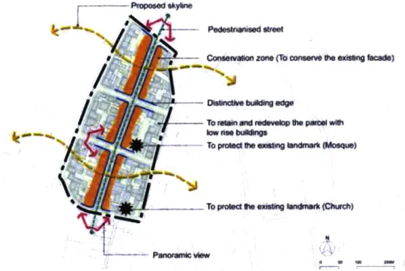
The urban design concept of the Nyarugenge Heritage Village directly points out landmarks, one of Kevin Lynch's city elements
(Joshi,
2013,, 6-37). As shown in the figure below, the main urbandesign interventions include the conservation of existing building facades. This distinctive building edge will run along a proposed pedestrianized street. Two existing Church Inkuru Nziza and Aga Khan Mosque should be preserved as landmarks.
Pdestrwwsed street
Consevon zone (To conserve e ezissng facade)
WO
lowmw<
on
bumaigTo protect M~e existing larndrr (Mcisquel
To protect the existng landmark (Church)
Figure 1 Nyarugenge Heritage Village urban design concept (Joshi, 2013,, 6-37)
III. Literature Review
As stated in the 2010 Nyarugenge master plan, Kigali intends to position itself as a global city. According to Sassen, the concept of the 'global city' has emerged alongside the rise of information technologies and the subsequent facilitated mobility of liquidity and capital. This current phase of the world economy emphasizes privatization, deregulation, and the entry of foreign firms in national economies. Global cities represent a spatial unit and scale which result from the blurring of the national as a spatial unit in favor of deregulation (Sassen, 2005). The concept of the global city is closely linked to the one of the networked economy given the intensity and variety of transactions between cities. Castells (2010) defines as a network as an open set of interconnected nodes whose quantity can expand with no bounds. The nature of the nodes is specific to the network in question but all networks share a common trait: the distance -whether it be physical, social, economic, political, or cultural - between their respective nodes approaches zero. The network society is therefore an appropriate topology for a capitalist economy rooted in globalization (Castells, 2010). Both Sassen and Castells note that the network society also engenders significant restructuring of power, culture, and experience. These shifts are also emphasized by Hudson who advances that global city transcends and challenges the notion and survival of the nation-state. Cities become fluid entities with real and metaphorical spaces in which flows of the international economy can operate (Hudson, 2015).
However, efforts to "globalize" by city authorities have met with criticism. For example, the global and network city viewpoints are criticized for a lack of acknowledgement of localized and national processes influencing globalization. Citing the work of Peter Taylor, Robinson notes that all cities are inherently global since they possess the liberty to insert themselves in global networks. This capacity underlines the competitiveness of city development and strategies that can sometimes be damaging to poorer cities (Robinson, 2012). Meagher concurs that cities in the global South are trying to outdo one another in the global economy circuit by adopting the knowledge and creative city brand. The author warns that these competitive tactics perpetuate a so-called 'telescopic urbanism' which excludes the urban poor from employment opportunities (Meagher, 2013). This notion of telescopic urbanism is at the center of much of the criticism towards developing cities aiming for the world city status. According to Watson, cities in sub-Saharan Africa are responding to the keen interest of international property development through various master plans for urban centers and satellite cities. These plans often present modernist visions rooted in globalized rhetoric such as new urbanism, smart and/or eco-cities. Implementing those visions will likely further impoverish and marginalize the poor populations disregarded in the master plans (Watson, 2013). Some authors, including African scholars, have put forth perspectives that nuances the critiques of the process and outcomes of the world class and modernism aspirations in the global South. AbdouMaliq Simone concedes that African cities, far from reaching world class city status, could incur new pressures by inserting themselves in the flows of the globalized network society. The effects of these pressures would not be insignificant in African cities and communities used to operating within confined scales. However, the author argues that Africans exert firm control in deliberately operating at a transnational and global arenas while maintaining a functional grounding at the local scales (Simone, 2001). For instance, the study of Addis Ababa's relation to modernity by Ejigu represents a case study supporting Simone's arguments. Ejigu explains that modernist projects in Ethiopia's capital should not be reductively equated with top-down political impositions nor with architectural and planning utopias. On the contrary, modernism spaces in Addis Ababa are co-constructed by the producers and the users of those spaces. Everyday citizens identify with and are proud of the commercial developments - an example modernist space- sprouting in the city (Ejigu, 2013).
The nuances presented by Simone and Ejigu add to the efforts of developing urban theories about and for the global South. Robinson writes that "decoloniz[ing] the field of urban studies" is
necessary to stimulate theoretical innovations beyond the Western-centric milieu of globalization (Robinson, 2002, p.54 9). In this vein, Enwezor presents distinct interpretations and forms of
modernity in different regions of the world. The author qualifies the European and Western modernity as a 'supermodernity' driven by notions of progress and rationality. Asia, particularly its southeastern regions, is undergoing a modernity that hybridizes western and alternative forms of development. This hybrid modernity has yet to gain the sweeping power and influence on
development narratives that supermodernity possesses. As for the African continent, its modernity is the most distant and even antagonistic to supermodernity. Enwezor calls it 'aftermodernity' as Africa
will become modern after the current forms of modernity end, after the continent distances itself from colonial modernity (Enwezor, 2010). In "The Art of Being Global", Ong expands on the notion of Asian modernity. Similarly to Robinson, the author criticizes the hegemonic urban
theories extrapolating Western ideas and forms of being global to non-Western contexts. Asian cities are successfully theorizing and embodying new and distinctive forms of global. In fact, this
reinvention of the art of being global has engendered an urban normativity positioning Singapore and Shanghai as beacons of modernity. The 'Singapore model' has been proven particularly prolific
in exporting its normative urban plans even beyond Asia (Ong, 2011). Given the existing influences from the West and the rising ones from the East, Ejigu applaudes the emerging theories from within Africa. However, he warns that the global dominance of capitalist cultural economy makes the search for an African cultural and spatial authenticity extremely difficult (Ejigu, 2013).
Difficulties in defining, gaining and maintaining cultural authenticity in African cities is a subject that has been widely discussed in other geographies as well. Hawkes explains that culture and public planning - and by extension city-making- are strongly connected. Among the many interpretations of culture, the author defines culture both as inherent values and aspirations and as processes to
transmit and develop those aspirations. Public planning, whether it be plans or policies, puts forth tangible interventions which are explicitly or tacitly influenced by culture. The author argues the connections between culture and public planning ought to be strengthened given that culture is "the bedrock of society." (Hawkes, 2001, p.3). According to Hawkes, this era of globalization has made discussions of the role of culture in society and in planning more salient. With cities in the global South aspiring for modernity, some question whether the modern can exist without dissolving the past to make way for the future (Berman, 1988). The past of most developing cities includes pre-colonial and pre-colonial phases followed by a progression into national and globalized phases (Grant, 2002). During this progression, Ong notes that cities are labelled 'post-colonial' as it is a designation encompassing a transitory phase soon to be replaced by a 'global city' label. However, positioning the postcolonial city along a trajectory of urban development does not resolve the perceived tensions between culture, planning, and identity. In fact, postcolonial cities are concerned with inauthenticity and can straddle an ambivalent identity that both rejects and identifies with colonial legacies. For instance, statements about identity can be made through the built environment using designs that aim for both cultural authenticity and international modernity. According to Ong, another contentious manifestation of the ambivalent postcolonial identity is the choice and selection of heritage areas (Ong, 2001).
The contention around heritage comes in part from the connected but effectively divergent notions of cultural authenticity and cultural distinctiveness. Hawkes explains that authenticity results from manifestations of culture within a community, which the community can itself identify.
Distinctiveness is also achieved through certain manifestations of culture. Evans lists practices of branding in European cities such as grand projects and 'edutainment' activities anchored around museums. The brand is expressed through so-called 'karaoke' architecture projects that forgo vernacular design in favor of exuberant designs aimed to impress foreign investors and politicians.
The author explains that cultural spaces are increasingly commodified given this hard-branding techniques. The cultural urban consumption occurs both in spatial and symbolic terms by
agglomerating museums in historic districts for example (Evans, 2003). City branding could ensure both cultural authenticity and distinctiveness according to Kavaratzis. The author explains that branding efforts can provide a city with a competitive edge necessary to attract investors and
tourists. However, branding goes beyond marketing techniques as it is able to concurrently strive for and enhance community development, local identity, and social cohesion. It is able to cater to multiple stakeholders and target both foreign investments and preservation of local heritage (Kavaratzis, 2004).
Kigali plans to use heritage sites as anchors in economic development and tourism promotion strategies, an approach that has been used in other countries. In the context of the United States, Reichl traces the emergence of the historic preservation movement in the 1970s after the urban renewal period. Historic preservation received political support as a strategy for commercial
development. At the time, an appealing outcome of historic district designations was an increase in property values and tax revenues (Reich, 1997). Benefits can also be felt in the development of new housing units with a significant portion being affordable. Nonetheless, the most valuable economic development outcome remain heritage tourism -- the tourism field is the third largest sector in the US. These direct benefits come with multiplier effects like job creation and downtown revitalization projects (Listoking et al., 1998). Chang (1997) touts the benefits of heritage tourism in the context of Singapore and dispels the assumption that the needs of foreign visitors are prioritized over those of the local community. The author argues that both the demand from locals for cultural activities and the demand from foreign tourists for leisure activities shape heritage conservation and tourism. Given these dual influences, the commoditization process should not be regarded as simply an outcome of touristic forces which inevitably lead to negative effects. Chang (1997) specifically dismisses the often cited negative effect of cultural erosion and inauthenticity. According to the author, "heritage is dynamic and ever changing" and can continue to be celebrated even in a new or altered form (Chang, 1997: 64).
Despite the arguments from Gale and similarly-minded scholars, the connections between heritage and economic development through tourism continue to face criticism. Markusen (2009) notes that the proliferation of arts, cultural and historic districts in the United States is occurring without much empirical research from urban planners and city officials. The author recommends to re-evaluate the approach of branding cities as cultural destinations, often done through flagship projects designed by renowned architects and other large investments meant to attract out-of-town tourists. The re-evaluation can be supported by empirical research showing citizens and residents could be more valuable targets of cultural tourism initiatives (Markusen, 2009). Nasser (2003) remarks that tourism planning tends to consider the touristic appeal of heritage sites through their built form. This strategy not shifts the focus of heritage areas away from their authentic cultural and social
significance but also redefines this significance in favor of tourism. To prevent the overexploitation and degradation of heritage assets, it is necessary to stop dissociating their built and urban forms
with the type of activities occurring in them. The author also advances the importance of merging land use planning with social ideals in order to balance the tourism influences with the needs and aspirations of local communities (Nasser, 2003). The changes in the conceptual development of cultural heritage presented by Loulanski (2006) echo the planning approaches recommended by Nasser (2003). Loulanski (2006) explains the concept of functional heritage is gaining more traction. Functional heritage emphasizes the people and the functions over the built form of heritage areas. Preservation can therefore shift from an objectified view of heritage to a more purposeful and sustainable approach (Loulanski, 2006).
IV. Analysis
Summative Content Analysis
Based on Chapters 2 and 3, the following key words and phrases were selected for the content analysis of planning documents: heritage, economic development, tourism development or tourism4, authentic, identity, and distinctive, tourism or tourism development. This selection can represent the two ends of the balance with 'authentic' and 'identity' expected to be related to local culture while 'distinctive' and 'tourism/tourism development' to global economic development.
The key words and phrases were entered in the Text Search Query tool of the NVivo Pro 11 software for each of the selected master plans. These master plans were discussed in Chapter 2 and are: the 2007 KCMP (only its fourth chapter), the 2010 Nyarugenge master plan, the 2010 CBD master plan, the 2013 Nyarugenge zoning report, and the 2013 KMP. The results of the Text Search Query includes a
list
of all the references to the key word or phrase searched. The query was conducted after enabling the option to find words stemming from the one entered in the tool. For instance, references to the noun 'distinctiveness' would be included in the query results for the adjective 'distinctive'. The references to each word or phrase query were individually read in their immediate context. Summary tables in the Appendix list the total number of references and the counts of individual references mentioned in a similar context within the selected master plans.The results of the content analysis show a clear departure between the conceptual master plan by OZ and the detailed master plans by Surbana in terms of their conceptualization of heritage preservation. In the chapter 4 of the KCMP, heritage was mostly conceptualized through the preservation of natural features. The word 'heritage' is mentioned four times in the chapter in the context of a proposed Heritage Memorial Park in the Kicukiro District. The heritage park would be part of a larger set of regional parks as noted in the Natural Features Plan, one of the three key maps that make up the KCMP. The Natural Features Plan maps 65% of Kigali as
4 The word 'tourism' was used in the analysis of the 2007 KCMP, 2013 Nyarugenge zoning report and 2010
unsuitable for urban development and necessary to protect given its environmental character (KCMP Chap4, 72).
From this observation, the preservation and enhancement of natural features can affect the type of growth in the urban fabric. This Heritage Memorial Park would be situated close to a proposed new city center to be located south of the existing one in the Nyarugenge sector. The KCMP states the new city center would not require much expropriation when developing given its proposed location on mostly unoccupied land. Plus, the construction of a new city center would be less challenging than redeveloping the existing Nyarugenge center (KCMP Chap4, 92).
The query for the word 'authentic' and words stemming from it yielded no results. The word 'identity' which could speak to cultural heritage was only mentioned in the fourth chapter of the KCMP. The sole reference to 'identity' is made in the context of housing typologies. Housing developments should have a sense of identity in addition to catering the various needs of households and providing them with a safe and private living environments (KCMP, 67). The context around 'distinctive', 'economic development', and 'tourism' did not show any explicit connections to cultural heritage preservation. The adjective 'distinctive' was not mentioned once in the document. The fives references to 'economic development' relate to a variety of strategies, none of them explicitly mentioning cultural heritage. One potential strategy to enhance economic development is to better integrate housing into the local economy. This integration could happen by linking housing to walkable and mixed-used neighborhood centers with a wide array of uses and amenities (KCMP Chap4, 65).
The master plan also notes the potential economic development potential of creating a free trade zone near the upcoming airport in Bugesera. This airport, albeit outside the
administrative boundaries of the Kigali City Province, ought to influence the development of the city. For instance, rail and transportation networks could be developed in response to the intensified import-export activities (KCMP Chap4, 105 & 108). In addition to new strategies in economic development, existing sources of economic growth should not be stifled. As
transportation networks intensify, highways and parkways are likely to cross through rural and peri-urban areas. This should not prevent residents of those areas from bringing agricultural and non-agricultural products to market and therefore stifle their sizeable contributions to the economy (KCMP Chap4, 81).
As previously noted, the three references to 'tourism' are not explicitly related to cultural heritage. Higher levels of tourism and economic activity have cause an increase in air traffic. Among other reasons, the new Bugesera airport is needed to absorb the excess air traffic because the existing international airport is rapidly reaching its capacity (KCMP Chap4, 104). The other two mentions of 'tourism' are made in the context of the Natural Features Plan. Although existing forests are set to