University of Groningen
Late Pleistocene and Holocene activity of the Atacazo-Ninahuilca Volcanic Complex
(Ecuador)
Hidalgo, Silvana; Monzier, Michel; Almeida, Eduardo; Chazot, Gilles; Eissen, Jean-Philippe;
van der Plicht, Johannes; Hall, Minard L.
Published in:
Journal of Volcanology and Geothermal Research
DOI:
10.1016/j.jvolgeores.2008.05.017
IMPORTANT NOTE: You are advised to consult the publisher's version (publisher's PDF) if you wish to cite from
it. Please check the document version below.
Document Version
Publisher's PDF, also known as Version of record
Publication date:
2008
Link to publication in University of Groningen/UMCG research database
Citation for published version (APA):
Hidalgo, S., Monzier, M., Almeida, E., Chazot, G., Eissen, J-P., van der Plicht, J., & Hall, M. L. (2008). Late
Pleistocene and Holocene activity of the Atacazo-Ninahuilca Volcanic Complex (Ecuador). Journal of
Volcanology and Geothermal Research, 176(1), 16-26. https://doi.org/10.1016/j.jvolgeores.2008.05.017
Copyright
Other than for strictly personal use, it is not permitted to download or to forward/distribute the text or part of it without the consent of the author(s) and/or copyright holder(s), unless the work is under an open content license (like Creative Commons).
Take-down policy
If you believe that this document breaches copyright please contact us providing details, and we will remove access to the work immediately and investigate your claim.
Downloaded from the University of Groningen/UMCG research database (Pure): http://www.rug.nl/research/portal. For technical reasons the number of authors shown on this cover page is limited to 10 maximum.
Late Pleistocene and Holocene activity of the Atacazo
–Ninahuilca Volcanic
Complex (Ecuador)
Silvana Hidalgo
a,b,⁎
, Michel Monzier
c,1, Eduardo Almeida
d, Gilles Chazot
b, Jean-Philippe Eissen
c,1,
Johannes van der Plicht
e, Minard L. Hall
aa
Instituto Geofísico, Escuela Politécnica Nacional, A.P. 17-01-2759, Quito, Ecuador
b
Laboratoire Magmas et Volcans, CNRS UMR 6524, 5 rue Kessler, 63038 Clermont-Ferrand, France
c
Institut de Recherche pour le Développement, Laboratoire Magmas et Volcans, IRD UMR 163, 5 rue Kessler, 63038 Clermont-Ferrand, France
d
Caminosca Cia. Ltda. Quito, Ecuador
eCenter for Isotope Research, University of Groningen, Nijenborgh 4, 9747 AG Groningen, Netherlands, and Faculty of Archaeology, University of Leiden,
PO Box 9515, 2300 RA Leiden, Netherlands
A B S T R A C T
A R T I C L E I N F O
Article history:
Received 1 November 2006 Accepted 26 May 2008 Available online 3 June 2008 Keywords: Atacazo–Ninahuilca Ecuador Holocene stratigraphy geochronology radiocarbon dating volcanic hazards
The Atacazo–Ninahuilca Volcanic Complex (ANVC) is located in the Western Cordillera of Ecuador, 10 km southwest of Quito. At least six periods of Pleistocene to Holocene activity (N1 to N6) have been preserved in the geologic record as tephra fallouts and pyroclasticflow deposits. New field data, including petrographic and whole-rock geochemical analyses of over forty soil and tephra sections, 100 pumice and lithic samples, and 10 new14C ages allow us to constrain: (1) the tephra fall isopachs and detailed characteristics of the last
two events (N5–N6) including volume estimates of the tephra and pyroclastic flow deposits and the corresponding volcanic explosivity index (VEI); (2) the petrographical and geochemical correlations between domes, tephras, and pyroclasticflow deposits; and, (3) the timing of the last 4 eruptive events and a period of quiescence that endured a few thousand years (1000–4000).
The last two eruptive events (N5 and N6) took place at around 4400 ± 35 yr BP and 2270 ± 15 yr BP, producing huge plinian and pyroclasticflow deposits. Taking into account the widely spread deposits of these VEI 5 eruptions, the present population of about 70 000 people, and the current infrastructure; the development of mitigation plans and deployment of monitoring systems at ANVC is highly recommended.
© 2008 Elsevier B.V. All rights reserved.
1. Introduction
More than sixty Quaternary volcanic complexes comprise the Ecuadorian Volcanic Arc (Fig. 1). Of these, at least seventeen have been active during the Holocene, and eight produced historical eruptions. This situation has prompted the reconstruction of the volcanic stratigraphy for numerous volcanoes throughout the Andean range, and the elaboration of hazard maps for most active and dangerous edifices (Hall, 1977; Barberi et al., 1988; Hall and Beate, 1991; Hall and Maruri, 1992; Hall and Mothes, 1994; Samaniego et al., 1998; Barba et al., 2008-this issue). During the last decade, Guagua Pichincha, Tungurahua, and Reventador volcanoes erupted, endan-gering Ecuadorian populations and infrastructures of high economic importance (such as the trans-Ecuadorian oil pipeline). This volcanic activity led to important human conflicts, and challenged the local and regional authorities.
The Atacazo–Ninahuilca Volcanic Complex (ANVC), the focus of this study, is located in the Western Cordillera of Ecuador (volcanic front), 10 km southwest of Quito (Fig. 1). Explosive activity at ANVC during the Holocene produced thick tephra layers and huge pyroclastic flow deposits that have traveled several kilometers westward from the vent. South of Quito, several small towns (e.g. Tambillo, Uyumbicho, Aloag, Tandapi, Canchacoto), the main Pana-merican highway, crossing the highland area from north to south, and the road leading from Aloag to Santo Domingo, linking the Northern highlands to the Coastal region; were built upon recent Holocene eruptive deposits, and are now positioned in high hazard zones. In the event of a reactivation of the ANVC, at least 70 000 people (INEC, 2001), the National Electrical System, and Quito's water supply could be adversely affected.
In order to better constrain the eruptive style and frequency of the ANVC, a stratigraphic, petrographic, geochemical, and chronological study was undertaken. Forty stratigraphic sections containing fallout andflow deposits related to the ANVC late Pleistocene to Holocene activity were studied mainly to the east and southwest of the complex. Carbonized wood and charred twigs found inside pyroclasticflow deposits or organic-rich paleosoils related to plinian fallout layers
⁎ Corresponding author. Instituto Geofísico, Escuela Politécnica Nacional, A.P. 17-01-2759, Quito, Ecuador.
E-mail address:shidalgo@igepn.edu.ec(S. Hidalgo).
1 Deceased.
0377-0273/$– see front matter © 2008 Elsevier B.V. All rights reserved. doi:10.1016/j.jvolgeores.2008.05.017
Contents lists available atScienceDirect
Journal of Volcanology and Geothermal Research
were dated by 14C technique at the Center for Isotope Research,
University of Groningen, Netherlands (Table 1). The conventional radiocarbon ages were calibrated to calendar years using the OxCal software (Bronk Ramsey, 2003). Average ages for the younger eruptions (N5 and N6 eruptive events; see below) were estimated using the same software. The data obtained from paleosols (N5: SA-38A and N6: SA-38C1) were not used in the average because they represent only minimal or maximal ages for an event, and their accuracy is generally lower than that of carbonized wood. The radiocarbon ages and the calibrated age ranges (confidence levels at 1 and 2 sigma) are listed inTable 1.
Pumice and juvenile lithic fragments used in petrographical and geochemical studies were sampled directly from domes, tephra, and pyroclasticflow deposits. Whole-rock geochemical analyses for major and trace elements were performed at the Université de Bretagne Occidentale, France. Petrographic and geochemical stu-dies were used to establish a correlation between the different Pleistocene and Holocene tephra and pyroclasticflow deposits and their related domes.
2. ANVC— main units: stratigraphy and geochronology of recent deposits
The ANVC can be subdivided into three main edifices: La Carcacha, Atacazo, and a group of recent domes. La Carcacha edifice is the oldest of the complex, composed of andesitic lava flows. The younger Atacazo stratovolcano is made up of several sequences of andesitic
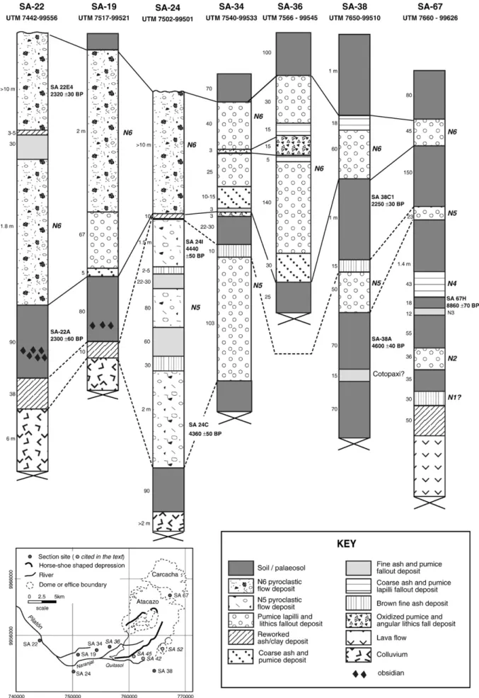
lavaflows and five satellite domes (Omoturco, Cuscungo, La Viudita, Gallo Cantana, and Arenal I). This edifice underwent a destabilization event that led to the formation of a SW oriented depression (5 × 7 km). Several late Pleistocene to Holocene domes (La Cocha I and II, Arenal II, Ninahuilca Chico I and II) extruded into this depression (Figs. 2 and 3). At least six periods of explosive activity, defined byAlmeida (1996)as N1 to N6, were associated with the formation of these domes. Explosive activity associated with their formation is preserved in the stratigraphic record as six tephra layers, and at least two different pyroclasticflow units cropping out more than 30 km from the vent. The tephra deposits overlie the Late Glacial moraines indicating an age younger than 10–12 ka (cf.Clapperton, 1993).
2.1. Late Pleistocene–Holocene domes
The youngest edifice of the ANVC is a dome complex, composed by five important domes: La Cocha I and II, Arenal II, Ninahuilca Chico I and II.
La Cocha I and II domes (3798 m) are located in the western part of the SW-opened depression of Atacazo edifice (Figs. 2 and 3c). La Cocha I dome was destroyed by an explosive eruption leaving a half-moon shaped structure with a 1.5-km-long scar. This explosive phase was followed by the emplacement of the younger La Cocha II dome. Assuming an original circular shape, the estimated diameter of this dome was likely about 3 km. These lavas contain plagioclase, orthopyroxene, clinopyroxene and Fe–Ti oxides; and have silica contents between 62 and 64 wt.%. An active fumarolicfield, about
Fig. 1. Location of the Atacazo–Ninahuilca Volcanic Complex (ANVC) in the Ecuadorian Volcanic Arc. Volcanic Centers are fromHall and Beate (1991). The cities shown on this map are: Ib = Ibarra, Q = Quito, La = Latacunga, Te = Tena, Am = Ambato.⁎ = volcano with historical activity.
17 S. Hidalgo et al. / Journal of Volcanology and Geothermal Research 176 (2008) 16–26
50 m in length, was discovered at the foot of the La Cocha II dome. Sulphur crystals, 1 mm in size, coat the orifices of low temperature gas emission vents.
Arenal II dome (4280 m) has a basal diameter of about 1.5 km and a relief of 600 m, with maximum slopes of 23°. This dome has grown along the northern Atacazo depression walls (Fig. 2). The silica con-tent of this lava is 63 wt.%, and the mineral assemblage is comprised of plg + opx + amph + Fe–Ti oxides.
Ninahuilca Chico I (3256 m) is a 1-km-diameter circular dome (500 m-high) located at the southwestern end of the Atacazo depression (Fig. 2). No sample could be obtained from this dome due to difficulties in accessing it. Ninahuilca Chico II (3824 m;Figs. 2 and 3c) is an E–W elongated dome (2.5×1.5 km) with a total relief of 700 m. This is less eroded part of the volcanic complex with very steep slopes that are frequently affected by small landslides. The eruptive products have a mineral assemblage of plg+ amph+ opx+Fe–Ti oxides ± apt. SiO2content is quite homogenous ranging around 65 wt.%.
2.2. Tephra deposits 2.2.1. N1 tephra layer
In the upperflanks of the ANVC, the N1 tephra layer is an oxidized 30-cm-thickfine brown ash and pumice layer overlying a 50-cm-thick grayish-red consolidated tuff which is in contact with the older Atacazo lavas. The sequence is overlain by a 35 cm paleosol, poor in
organic material. No radiocarbon age could be determined for this layer due to the scarcity of organic or carbonized material. Never-theless, as it is overlying the Late glacial moraines, this horizon must be younger than 10–12 ka. This layer is exposed about 5 km NE of the Atacazo depression rim (section SA-67,Fig. 4). Based on petrographical or geochemical data, no link with any of the intra-depression domes could be established.
2.2.2. N2 tephra layer
In section SA-67 (Fig. 4), N2 tephra layer is a well-sorted 36-cm-thick fallout containing orange oxidized pumices, fragmented hydrothermally altered lithics, and afine-grained matrix (plagio-clase, pumice, lithics and glass shards). It is overlain by a 55-cm-thick dark paleosol with yellow pumices at the base. Whole-rock analysis from one of N2 tephra layer pumices yields 61 wt.% SiO2
(Fig. 5), and the mineral assemblage is comprised of plg + opx + Fe–Ti oxides ± cpx. As for N1 tephra, no radiogenic age could be obtained for this deposit, however, given its stratigraphic position; it must be younger than 10–12 ka.
2.2.3. N3 tephra layer
In section SA-67, N3 tephra is a 12-cm-thick well-sorted coarse yellow ash layer. It contains 1-cm white/yellow pumices and small (1–2 cm) hydrothermally altered and fragmented lithics. Fine ash, lithics, and plagioclase, Fe–Ti-oxides and orthopyroxene crystals
Table 1
Radiocarbon ages (pre-1950) obtained for carbonized wood, charred twigs and paleosol horizons related to the recent volcanic activity of the Atacazo–Ninahuilca Volcanic Complex Stratigraphic unit Dated material Deposit Sample number Radiocarbon age (yr BP)
Calibrate age CalBC 68.2% (1 sigma) (yr BC)
Calibrated age CalBC 95.4% (2 sigma) (yr BC) Laboratory number δ13C (‰) Cv (%) N3 Soil Palaeosoil overlying N3
fallout SA-67H 8860 ± 70 8210 (60.9%) 7940 8240 (95.4%) 7750 GrN-28732 −25.26 59.1 7930 (2.2%) 7910 7900 (3.4%) 7870 7860 (1.7%) 7840 N4 Charred twigs
Ashflow Almeida (1996) 5440 ± 111 4440 (2.6%) 4420 4500 (95.4%) 3990 4370 (44.4%) 4210 4200 (8.9%) 4160 4150 (1.0%) 4140 4130 (11.3%) 4050 N5 Carbonized wood
Pyroclastic Flow SA-24C 4360 ± 50 3080 (2.1%) 3070 3270 (1.6%) 3240 GrN-28725 −27.72 73.8 3030 (66.1%) 2900 3100 (93.8%) 2880
N5 Carbonized wood
Pyroclastic Flow SA-24 I 4440 ± 50 3330 (23.8%) 3230 GrN-28726 −25.46 70.90 3180 (3.4%) 3150 3340 (39.5%) 3150 3120 (32.3%) 3010 3140 (55.9%) 2910 2980 (3.5%) 2960 2950 (5.2%) 2920 N5 Average 4400 ± 35 3090 (11.6%) 3060 3270 (3.2%) 3230 3040 (59.6%) 2920 3110 (92.2%) 2910 N5 Soil Palaeosoil underlying
N5 fallout SA-38A 4600 ± 40 3500 (30.5%) 3450 3520 (42.4%) 3400 GrN-28727 −25.46 54.2 3440 (1.2%) 3430 3390 (34.2%) 3310 3380 (30.0%) 3330 3230 (9.1%) 3170 3210 (3.0%) 3190 3160 (9.7%) 3100 3150 (3.5%) 3130 N6 Carbonized wood
Pyroclasticflow SA-42D 2220 ± 40 370 (8.2%) 340 390 (95.4%) 170 GrN-28729 −25.51 66.7 330 (60.0%) 200
N6 Carbonized wood
Pyroclasticflow SA-52B 2230 ± 40 380 (12.5%) 350 390 (95.4%) 190 GrN-28731 −24.87 76.3 320 (55.7%) 200
N6 Soil Palaeosoil underlying N6-fallout SA-38C1 2250 ± 30 390 (24.7%) 350 400 (30.2%) 340 GrN-28728 −22.24 59.9 300 (39.5%) 230 330 (65.2%) 200 220 (4.0%) 210 N6 Carbonized wood
Pyroclasticflow SA-45B 2260 ± 30 390 (32.1%) 350 400 (36.2%) 340 GrN-28730 −23.06 68.8 290 (36.1%) 230 320 (59.2%) 200 N6 Charred twigs Palaeosoil SA-22A 2300 ± 30 400 (59.4%) 360 410 (69.1%) 350 GrN-28723 −26.09 67.2 270 (8.8%) 260 300 (26.3%) 230 N6 Carbonized wood
Pyroclasticflow SA-22E4 2320 ± 30 410 (67.1%) 370 420 (82.4%) 350 GrN-28724 −23.33 67.3 270 (1.1%) 260 290 (13.0%) 230 N6 Aquater (1980) 2370 ± 70 760 (14.6%) 690 800 (90.6%) 350 550 (53.6%) 380 300 (4.8%) 200 N6 Average 2267 ± 17 390 (49.1%) 350 400 (53.7%) 350 280 (19.1%) 260 300 (40.4%) 23 220 (1.2%) 210
comprise the matrix. A single white pumice fragment from this layer yields 64 wt.% SiO2(Fig. 5), and has a mineral assemblage similar to
that of the N2 pumices. This layer is overlain by an 18-cm-thick organic-rich soil, whose base has been dated at 8860 ± 70 yr BP, indicating that the N3 tephra is slightly older than this age. 2.2.4. N4 tephra layer
The N4 tephra layer at SA-67 section is a 43-cm-thickfine greenish ash layer containing plagioclase and quartz crystals, fragmented lithics and 1–2 mm gray pumices, with rare 2–3 cm pumices scattered throughout this deposit. It is overlain by a 146 cm brown dark paleosol containing amphibole-rich yellow pumices at the base. The top of this deposit has been strongly weathered and is partially transformed into a brown soil. Pumices from this N4 layer yield 62 wt.% SiO2(Fig. 5) and
have a mineral assemblage comprised of plg + opx + amph+ Fe–Ti oxides. 2.2.5. N5 tephra layer
In section SA-67 (Fig. 4), N5 fallout is a 23-cm-thick well-sorted layer composed of 2–4 cm sub-angular yellow/orange pumices, gray angular
lithics, as well as hydrothermally altered lithics (1–2 cm in diameter). The matrix constitutes 20% of the deposit and is composed of coarse ash (plagioclase, amphibole and glass shards). In sections SA-38 and SA-34 (Fig. 4), this layer has a thickness of 50 and 103 cm, respectively. In section SA-34 (which lies along the axis of dispersion, see below), this layer shows an oscillatory grading, being inverse at the base of the layer and changing to normal grading from the middle of the deposit to the top. The pumices reach a maximum of 7 cm in diameter with an average diameter of 3–4 cm. Abundant (30%) 2–3-cm reddish hydrothermally altered dacitic lava lithics are present. In this section, the fallout deposit is overlain by 10 cm of brownfine ash, and a paleosol horizon with variable thickness (22–30 cm). Silica contents of analyzed pumices ranges from 61 to 63 wt.%, with a mineral assemblage bearing plg +amph +opx + Fe–Ti oxides. In section SA-38 (Fig. 4), a 70-cm-thick dark paleosol underlies the N5 fallout, the upper part of the paleosol yields an age of 4600 ± 40 yr BP. 2.2.6. N6 tephra layer
In section SA-67, the N6 fallout deposit is a well-sorted 45-cm-thick layer (Fig. 4). It is dominantly made up of sub-angular 2–5 cm
Fig. 2. Schematic map of the geology of the Atacazo–Ninahuilca Volcanic Complex (ANVC), including the older La Carcacha and Atacazo edifices, the Atacazo satellite domes (1 = Arenal I, 2 = Cuscungo, 3 = La Viudita, 4 = Gallo Cantana), and Late Pleistocene–Holocene intra-depression domes. Location of the main stratigraphic sections is also shown.
19 S. Hidalgo et al. / Journal of Volcanology and Geothermal Research 176 (2008) 16–26
white/yellow pumices with some scattered pumices up to 10 cm in diameter. Gray and/or reddish hydrothermally altered lithics (2–3 cm) are also present. The matrix is coarse ash formed by plagioclase, amphibole and glass shards. In section SA-34 (Figs. 3d and 4), this
layer overlies a dark paleosol of variable thickness and is capped by the modern soil.
This deposit is best exposed 5 km southwest of the vent (Ninahuilca Chico II), in the zone of Canchacoto (section SA-36;Fig. 4). At this
Fig. 3. a. ANVC aerial view from the SE. The southern external domes Omoturco, Cuscungo, and La Viudita appear in foreground; Arenal I, La Cocha II and Ninahuilca Chico II appear behind ancient Atacazo lavas. b. La Carcacha and Atacazo ancient edifices and the highly populated area of the south of Quito. c. La Cocha and Ninahuilca Chico II domes inside the Atacazo depression. d. N5 and N6 plinian fallout deposits (Section SA-34). e. N6 pyroclasticflow deposits at 6 km from the vent (Section SA-42). Note the large amount of carbonized material found inside these deposits. f. N6 pyroclasticflow deposits at 16 km from the vent (Section SA-22).
Fig. 4. Locations and stratigraphic correlations of the seven most representative sections of the recent ANVC pyroclastic deposits. Cotopaxi and GP (Guagua Pichincha) refer to fallouts from these two volcanoes. Thickness of the units is given in centimeters (except where indicated in meters). The new radiocarbon ages are also shown. Inset: Location of sections SA-42, SA-45 and SA-52 (cited in the text).
21 S. Hidalgo et al. / Journal of Volcanology and Geothermal Research 176 (2008) 16–26
location, the deposit is 240 cm-thick and preserves a complete eruptive sequence. At the base of the deposit lies a 30 cm coarse ash and pumice layer, rich in 1-mm-size fragmented crystals of plagioclase, amphibole, Fe–Ti oxides, subordinate orthopyroxene, glass shards and sub-angular tiny pumices. This ash and pumice layer is conformably overlain by a 140-cm-thick reverse graded tephra fallout deposit, in which angular white pumices (65% of the deposit) reach a maximum diameter of 7 cm, and an average diameter of 2 cm. Angular gray and reddish hydrothermally altered lithics are also present (5%; 3–4 cm of maximum diameter). The matrix (30% of this layer) is made up of plagioclase, amphibole, Fe–Ti oxides crystals, glass shards, tiny crushed pumices and fragmented lithics.
Overlying the pumice fallout layer is a 5-cm-thick gray-greenish coarse ash and pumice fallout. Its composition is the same as that of the previous layer matrix. Rare pumice clasts may reach 1 cm in diameter. This layer is overlain by a 15-cm-thick fallout deposit which is comprised of regular 2–4 cm angular pumices (40%) and reddish hydrothermally altered lithics (almost 30%). The matrix (30%) is similar to that of the previous layer. Clasts from the topfive centimeters of this layer are typically 1–1.5 cm in diameter. A 15-cm-thick layer of coarse ash and pumices overlies the lithic-rich layer. This gray-brown ash is comprised of plagioclase, amphibole, Fe–Ti oxides crystals, glass shards, fragmented pumices and lithics. Pumices in this layer do not exceed 1 cm.
At the top of the section, there is a brown-yellow 30-cm-thick reverse graded tephra fallout deposit. Light yellow pumices (50% of the deposit) reach maximum diameters of about 6 cm, they have a
range of 62 to 65 wt.% SiO2and a mineral assemblage similar to N5
pumices with the addition of scarce apatite. Angular gray lithics make up 5–10% of the deposit. Their diameters do not exceed 2 cm. Reddish hydrothermally altered lithics are less common than in the previous layers. The fallout matrix is gray-brown coarse ash.
A sample of the paleosol directly beneath the tephra fallout deposit in section SA-38 yields an age of 2250 ± 30 yr BP.
2.3. Pyroclasticflow deposits 2.3.1. N4— ash-flow deposit
This deposit underlies N5 tephra fallout in section SA-30 (20 km SW of the Atacazo depression center). Its thickness is about 80 cm and most of the deposit has almost completely degraded into soil. Nevertheless, scarce plagioclase and amphibole crystals, tiny pumices and carbonized leaves are still distinguishable from the surrounding matrix. Indeed, the ubiquitous presence of the carbonized leaves and little charcoal pieces is the clue to recognize this deposit as an ash-flow. Carbonized material at the base of the deposit yields a14C age of
5440 ± 110 yr BP (Almeida, 1996). 2.3.2. N5— pyroclastic flow deposit
In section SA-24, the N5 eruptive period is represented by a gray-pink coloured ash-and-pumice deposit. The matrix forms 75% of the volume. It contains coarse-grained ash, rich in glass shards, crushed pumices and lithics, plagioclase, amphibole, quartz, and Fe–Ti oxides. Pumice blocks comprise 15% of the deposit while white andesitic and
Fig. 5. Diagrams a. K2O b. TiO2, vs. SiO2and c. La/Yb vs. Yb diagrams, showing the geochemical relations between tephra layers pumices, blocks and pumices from the pyroclasticflow
dacitic lithics comprise 10%. Pumices blocks have 64 to 65 wt.% SiO2,
and the mineral assemblage of these rocks is the same as that of N5 tephra layer pumices.
This deposit is widely distributed around the Atacazo edifice, exposed in almost all the ravines with variable thickness (1–10 m) depending on the amount of erosion. Far to the southwest, the deposit filled the fluvial valleys of the Quitasol, Naranjal and Pilatón rivers, reaching maximum heights of about 120 m over the present day
bottom of the valley, cropping out even near the town of Tandapi (section SA-24,Fig. 4). The flow is crudely stratified. Fine ash-rich layers are interbedded with lenses filled by rounded pumices of varying size (2–8 cm with rare 25 cm blocks) and oxidized clay-rich layers. Carbonized wood is abundant throughout the deposit. At section SA-24 the deposit overlies an ancient colluvium comprised of metamorphic blocks within a purple clay-rich matrix. The top of the section is crowned by an incipient soil. Two carbonized wood samples
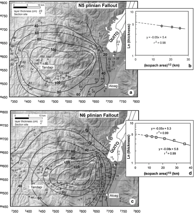
Fig. 6. a and c. Isopachs for N5 and N6 plinian tephra fallouts. Crosses indicate the sections where measurements were made. Thickness is indicated in cm. b and d. Ln (thickness) vs. Isopach area for N5 and N6 fallout isopachs, indicating the theoretical thinning of the deposits.
23 S. Hidalgo et al. / Journal of Volcanology and Geothermal Research 176 (2008) 16–26
from this pyroclasticflow deposit yield coherent ages of 4360±50 and 4440 ± 50 yr BP.
2.3.3. N6— pyroclastic flow deposit
In several sections, the N6 eruptive period is represented by a deposit comprised by ash, pumices and dacitic blocks. This deposit corresponds to pyroclastic flows which are better preserved than those from the previous N5 period (Figs. 4 and 7). In general, the deposit appears light gray in colour. The matrix containsfine to coarse ash which is comprised of glass shards, tiny pumices, fragmented lithics, and crystals of plagioclase, amphibole, quartz, titano-magne-tite and scarce ilmenite. The pumice block content is higher than in N5 deposits, reaching 20–30%, while the lithics (mainly dacitic lavas) content is of the same order (10%). Silica content of pumice clasts are around 64 wt.%, with a mineral assemblage of plg + amph + opx + Fe–Ti oxides ± apt.
Those deposits cropping out in the areas close to the Ninahuilca Chico II dome (6 km from the dome Fig. 3e, SA-42) are crudely stratified with lenses of rounded pumice completely fines depleted. These were likely emplaced by grain-flow regimes (Hunter, 1985). Far to the west (16 km from the dome;Fig. 3f), on the Tandapi–Santo Domingo road (60 m above the Pilatón valley bottom; section SA-22;
Fig. 4) the same pyroclasticflow deposit contains several fine ash and clay layers that define vague stratifications (Fig. 3f). At SA-19 (Fig. 4) theflow overlies the N6-plinian fallout, which in turn reposes over a dark brown paleosol horizon.
Carbonized wood was sampled from four different outcrops and yield ages of 2220±40 yr BP (section SA-42), 2230±40 yr BP (section SA-52), 2260±30 yr BP (section SA-45) and 2320±30 yr BP (Fig. 4, section SA-22). Charred twigs from the paleosol horizon underlying the pyroclasticflow deposit in section SA-22 yield an age of 2300 ±30 yr BP.
3. Correlating tephra layer deposits to late Pleistocene to Holocene intra-depression domes
Pumices sampled from the fallout layers and pyroclastic flow deposits can be correlated to the late Pleistocene–Holocene lava domes via whole-rock major and trace-element chemistry and mineralogical composition. Overall, there is an increase in silica as well as other major and trace elements from older to younger units (Fig. 5). As a result, several trace elements (for instance La/Yb,Fig. 5) have proven to be very useful in discriminating between each unit.
La Cocha I dome is an andesitic lava (61.3 wt.% SiO2) with
distinctively low K2O and TiO2contents and La/Ce and La/Yb ratios
relative to the other units (Fig. 5). Pumice from the N2 tephra layer plots similarly, except for TiO2, whose concentration is a little higher
in the tephra pumice. Mineral assemblages are the same for the dome and pumices samples, further corroborating the link between N2 tephra layer and La Cocha I dome.
La Cocha II dome rocks have medium K2O and TiO2contents with
La/Yb ratios around 14, (Fig. 5). These lavas are plg + opx + cpx + Fe–Ti oxides-bearing andesites and dacites. Their chemical compositions and mineral assemblage are similar to that of the N3 pumice. A slight positive correlation is observed in K2O vs. SiO2plots. Although N2 and
N3 pumices have similar mineral assemblages, the whole-rock analyses show that they are chemically distinct.
Arenal II dome is composed of a medium-K, plg + amph + opx + Fe– Ti oxides-bearing dacitic lava. Mineral and chemical compositions are nearly identical to that of the N4 pumice (Fig. 5). Overall, the N4 pumices have a homogeneous composition similar in SiO2to that of La
Cocha II dome, but slightly lower in TiO2and La/Yb ratios. Both, the
dome lavas and the N4 pumice include amphibole, which appears for thefirst time in the sequence of tephra layers.
N5 tephra layer and pyroclasticflow deposit samples display the largest variation in SiO2. The pumice clasts are medium-K
amphibole-bearing dacites. Pyroclasticflow pumices have 1–2 wt.% higher SiO2
contents relative to those in the tephra layer (Fig. 5). Mineral assemblage is comprised of plg + amph + opx + Fe–Ti oxides. No correlation could be established between these products and any of the intra-depression domes. Nevertheless, given that the only dome not sampled in this study is Ninahuilca Chico I, and tephra grain size argues for a local source, we strongly suspect a link between this dome activity and N5 eruptive period. Additionally, the relative chronology of dome emplacement suggests that Ninahuilca Chico I formed before Ninahuilca Chico II, supporting the contention that this dome could have been related to N5 eruptive period deposits.
Ninahuilca Chico II lavas are medium-K amphibole-bearing dacites with a homogeneous composition. N6 tephra and pyroclasticflow samples overlap Ninahuilca Chico II dome chemical and mineralogical compositions. Samples vary in composition from 64 to 66 wt.% SiO2
(Fig. 5). In the field, these rocks are quite similar to N5 period products; nevertheless, they can easily be distinguished from each other by their different TiO2contents.
4. Discussion
4.1. Tephra distribution and volumes of the last two eruptions 4.1.1. Fallout axes
The older N1 to N4 fallouts are so poorly exposed that no isopachs map could be drafted for these deposits. Three approximate isopachs (100–80–60 cm) have been drawn for N5 fallout deposits, while five better constrained isopachs (120–100–80–60–40 cm) have been produced for the most recent N6 sequence (Fig. 6). However, thinner deposits, important in the calculation of tephra volumes were not found in the studied area, so the estimations of tephra volumes does not include the distalfine ash that may account for an important part of the total volume. In both cases, fallout axes are oriented to the WSW, consistent with the known dominant wind direction in the region. 4.1.2. Tephra volumes
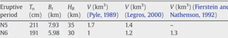
Isopach maps were used to calculate tephra volumes for N5 and N6 plinian fallouts using the equation ofPyle (1989), V = 13.08 To(bt)2,
where V is the total volume of tephra, Tois the maximum theoretical
thickness of the deposit extrapolated after plotting the logarithm of isopach thickness versus the square root of the area enclosed by that isopach, and btis the thickness half distance along minor axis of the
isopach plot (Table 2). Another formulation, that ofLegros (2000), V = 3.69tiAi, which uses only one isopach surface (Ai) and its thickness
(ti), was also used for comparison with thefirst estimation (Table 2). It
is important to note that only minimal volumes could be estimated using this last formulation. In order to accurately determine the N6 plinian fallout volume, we used the approach from Fierstein and Nathenson (1992), which integrates with respect to the depositional area in order to accommodate irregularly shaped isopachs. All the resulting volumes are shown inTable 2. For N5 plinian fallout deposit, both volume calculations yield consistent results (1.7 km3using Pyle's formulation and 1.4 km3 using Legros's equation). For N6 deposit,
Legros (2000), Fierstein and Nathenson (1992) and Pyle (1989)
approaches also produced consistent results (1.3, 1.2, and 0.9 km3,
respectively).
Table 2
Parameters used in the calculation of N5 and N6 plinian fallout volumes and volume estimations using different formulations (Pyle, 1989; Fierstein and Nathenson, 1992; Legros, 2000) Eruptive period To (cm) Bt (km) HB (km) V (km3 ) (Pyle, 1989) V (km3 ) (Legros, 2000) V (km3 ) (Fierstein and Nathenson, 1992) N5 211 7.93 35 1.7 1.4 – N6 191 5.98 30 1 1.2 1.3
Column heights for these two eruptions were estimated by
Almeida (1996)at 35 km for N5 and 30 km for N6. These values are quite high and may result from an overestimation related to the use of the largest diameter of pumices and lithics instead of the average of three sides of each element (MP and ML). Assuming an overestimation of 20%, the eruptive columns still reach significant heights (N20 km). Combining these two parameters, the column height and tephra volume, a VEI (Volcanic Explosivity Index;Newhall and Self, 1982) of 5 has been assigned to both the N5 and N6 eruptions. These estimates and the characteristics of both fallout deposits, confirm the plinian character of these eruptions.
4.2. Pyroclasticflow deposits distribution and volumes
Few accessible outcrops combined with the severe erosion of the N5 and N6 pyroclasticflow deposits have greatly inhibited mapping of the distribution of these deposits. With the aim of constraining the distribution of pyroclasticflow deposits, a numerical simulation of these events has been done. Fig. 7 shows the probable original distribution of the deposits using the VolcFlow algorithm (Kelfoun and Druitt, 2005), which is a dynamic model that makes simulations of dense isothermal volcanicflows, based on the depth-average solution of the granularflow equations.
The distribution of pyroclastic flow deposits allows for the estimation of the probable volume of the N6flow deposit. With an average thickness of 10–20 m and a maximal coverage area of 41 km2,
the total estimated volume is 0.4 to 0.8 km3. This additional volume was taken into consideration when assigning a VEI of 5 to the N6 eruptive period.
4.3. Recurrence interval
Chronological data obtained for N6 deposits yield an age of 2270 ± 15 yr BP (between 400 and 230 BC calibrated ages with 2 sigma confidence level). The soil underlying the N5 plinian deposits is older than the average age obtained from the carbonized wood in the N5 pyroclasticflow deposit (Section SA-24). This average age yields 4440± 35 yr BP (between 3270 and 2910 BC). We have assigned ages of 5440 ± 111 yr BP (4500–3990 yr BC) to N4 (Almeida, 1996) andN8860±70 yr BP (8240–7750 yr BC) to N3 (age of the soil over N3 fallout). Given that N2 tephra layer overlies Late glacial moraines, related activity could have taken place between 12 kyr and≈8 kyr ago. Based on these dates, the eruptive recurrence interval ranges from about 1000 yr between N4 and N5 to 2700 yr between N5 and N6, and≈3700 yr for the period N4–N3.
5. Conclusions
ANVC shows a recurrent pattern of explosive activity during the late Pleistocene and Holocene times. Six tephra layers (N1 to N6) have been described, and based on geochemical and petrographical descriptions; a correlation between tephra layers and the younger domes of the complex has been established.
The fallout and pyroclasticflow deposits described in this study confirm that all the Holocene eruptions of the ANVC were highly explosive plinian events. The volcanic explosivity index of the N5 and N6 eruptive periods (VEI = 5) exceeds that of all of the most violent eruptions of the last century in Ecuador. The deposits produced by the last two eruptions of ANVC (N5 and N6) underlie presently inhabited
Fig. 7. Distribution of N6 pyroclasticflow deposits. Shown in white is the probable distribution based on VolcFlow simulation (Kelfoun and Druitt, 2005), while shown in circlesfilled pattern are the pyroclasticflow outcrops distribution based inAlmeida (1996)and our ownfieldwork. Notice that probable distribution is covered on the valleys by the actual outcrops.
25 S. Hidalgo et al. / Journal of Volcanology and Geothermal Research 176 (2008) 16–26
areas with total populations of about 70 000, to the south of Quito, Tambillo, Uyumbicho, Aloag, Tandapi, and are exposed along part of the main highway linking the northern highlands to the coastal regions (Aloag–Santo Domingo road) as well as the Pan-American Highway. Should ANVC reactivate, it will compromise the National electrical infrastructure and part of the water supply for the southern Quito area. Fine ash distribution could have regional implications.
The combination of the few available chronological data from the literature with the ten new ages provided here shows that, for the recent volcanic activity, the recurrence period between eruptions is on the order of a few thousand years, ranging from about ~ 1000 yr to ~ 3700 yr. Considering the typical quiescence period of 1000–4000 yr between eruptions, and the age of the last recognized activity (2270 ± 15 yr BP), the possibility of a new eruption is increasing. As a result, mitigation plans should be elaborated and the hazard map improved. Additionally, a basic monitoring system should be deployed to look for signs of unrest at ANVC. An early warning system could help authorities to better handle a potential volcanic crisis, mitigating the effects of a new eruption for the population, the infrastructure and economic activities developed near the volcano.
Acknowledgements
This study benefited from the financial support of the IRD (Institut de Recherche pour le Développement, France), FUNDACYT (Fundación para la Ciencia y la Tecnología, Ecuador), and the French Embassy in Ecuador. Collaboration from the Departamento de Geofísica de la Escuela Politécnica Nacional was much appreciated. Our deepest thanks go out to Marc Souris and Jorge Aguilar for providing the data and generating the ANVC DEM. We thank Karim Kelfoun for his invaluable help in the modelling of the distribution of pyroclasticflow deposits. Whole-rock analyses have been carried out at the Université de Bretagne Occidentale by Joseph Cotten, whom we deeply acknowl-edge. Comments from Jean-Luc Le Pennec aided us in the develop-ment of this manuscript. Special thanks to Judy Fierstein and an anonymous reviewer whose comments greatly improved this paper.
References
Almeida, E., 1996. Dinámica de las Erupciones del Volcán Ninahuilca. 7° Congreso de Geología, Minas, Petróleo y Medio Ambiente, Quito.
Aquater, 1980. Informe geovolcanológico, Proyecto de investigación Geotérmica de la República del Ecuador, Estudio de Reconocimiento. Informe preparado por Aquater y BRGM para OLADE e INECEL, inédito. 54 p.
Barba, D., Robin, C., Samaniego, P., Eissen, J.P., 2008. Holocene recurrent explosive activity at Chimborazo volcano (Ecuador). Journal of Volcanology and Geothermal Research 176, 27–35 (this issue).
Barberi, F., et al., 1988. Plio-Quaternary volcanism in Ecuador. Geological Magazine 125 (1), 1–14.
Bronk Ramsey, C., 2003. OxCal v. 3.9, Oxford.
Clapperton, C.M., 1993. The Quaternary Geology and Geomorphology of South America. Elsevier, Amsterdam.
Fierstein, J., Nathenson, M., 1992. Another look at the calculation of fallout tephra volumes. Bulletin of Volcanology 54, 156–167.
Hall, M.L., 1977. El Volcanismo en el Ecuador. IPGH. Instituto Geográfico Militar, Quito. 120 pp.
Hall, M.L., Beate, B., 1991. El volcanismo Plio-Cuaternario en los Andes del Ecuador. In: Mothes, P. (Ed.), El Paisaje Volcánico de la Sierra Ecuatoriana, Quito, pp. 5–18. Hall, M.L., Maruri, W., 1992. Mapa de los peligros volcánicos potenciales asociados con el
Volcán Ninahuilca, Provincia de Pichincha. Instituto Geofísico— Escuela Politécnica Nacional, Quito.
Hall, M., Mothes, P., 1994. Tefroestratigrafía Holocénica de los Volcanes Principales del Valle Interandino, Ecuador. Estudios de Geografía 6, 47–67.
Hunter, R.E., 1985. A kinematic model for the structure of lee side deposits. Sedimentology 32, 409–422.
INEC, 2001. Censo de población 2001, pp.http://www.inec.gov.ec/web/.
Kelfoun, K., Druitt, T., 2005. Numerical modeling of the emplacement of Socompa rock avalanche, Chile. Journal of Geophysical Research 110, B12202.1–12202.13. doi:10.1029/2005JB003758.
Legros, F., 2000. Minimum volume of tephra fallout deposit estimated from a single isopach. Journal of Volcanology and Geothermal Research 96, 25–32.
Newhall, C.G., Self, S., 1982. The volcanic explosivity index (VEI): an estimate of explosive magnitude for historical volcanism. Journal of Geophysical Research 87, 1231–1238. Pyle, M., 1989. The thickness, volume and grainsize of tephra fall deposits. Bulletin of
Volcanology 51, 1–15.
Samaniego, P., Monzier, M., Robin, C., Hall, M.L., 1998. Late Holocene eruptive activity at Nevado Cayambe Volcano, Ecuador. Bulletin of Volcanology 59 (7), 451–459.