HAL Id: hal-02991728
https://hal-brgm.archives-ouvertes.fr/hal-02991728
Submitted on 6 Nov 2020
HAL is a multi-disciplinary open access
archive for the deposit and dissemination of
sci-entific research documents, whether they are
pub-lished or not. The documents may come from
teaching and research institutions in France or
abroad, or from public or private research centers.
L’archive ouverte pluridisciplinaire HAL, est
destinée au dépôt et à la diffusion de documents
scientifiques de niveau recherche, publiés ou non,
émanant des établissements d’enseignement et de
recherche français ou étrangers, des laboratoires
publics ou privés.
Véronique de Montety, Christelle Batiot-Guilhe, Claudine Lamotte
To cite this version:
Marie-Amélie Pétré, B. Ladouche, Jean-luc Seidel, Romain Hemelsdaël, Véronique de Montety, et al..
Hydraulic and geochemical impact of occasional saltwater intrusions through a submarine spring in a
karst and thermal aquifer (Balaruc peninsula near Montpellier, France). Hydrology and Earth System
Sciences, European Geosciences Union, 2020, �10.5194/hess-2020-292�. �hal-02991728�
Hydraulic and geochemical impact of occasional saltwater intrusions
1
through a submarine spring in a karst and thermal aquifer (Balaruc
2
peninsula near Montpellier, France)
3
Marie-Amélie Pétré1,2*, Bernard Ladouche3, Jean-Luc Seidel1, Romain Hemelsdaël4,
4
Véronique de Montety1, Christelle Batiot-Guilhe1, Claudine Lamotte3
5
1HydroSciences Montpellier, Montpellier University, CNRS, IRD, Montpellier, France
6
2Now at North Carolina State University, Marine, Earth, and Atmospheric Sciences Department,
7
Raleigh, NC 27695, United States 8
3BRGM, Montpellier University, Montpellier, France
9
4Geosciences Montpellier, Montpellier University, CNRS, Montpellier, France
10 11
*corresponding author: Marie-Amélie Pétré, marieamelie.petre@gmail.com 12
13
Abstract
14
Submarine springs are a common discharge feature of the karst aquifers along the
15
Mediterranean coast. In some instances, occasional and localized saltwater intrusions can occur
16
through the submarine spring and negatively impact the quality of the groundwater resource.
17
The hydraulic and geochemical behavior of a submarine spring discharging into the Thau
18
lagoon just offshore of the Balaruc peninsula near Montpellier, France has been characterized
19
to determine the impacts of such phenomena to better understand the dynamics of a regional
20
karst aquifer and improve its groundwater management. This work is based on both historical
21
and new hydrogeological and geochemical data, illustrating 6 occasional saltwater intrusion
22
events (from 1967 to 2014) in the Thau lagoon area (southern France).
23
Hydraulic perturbation of the aquifer is propagated instantly within the Balaruc-les-Bains
24
peninsula and reaches a distance of about 5 km upgradient within 9 days. Comparison of
25
hydraulic heads during seawater intrusion events in 2010 and 2014 indicates an aggravation of
26
the phenomenon with an increase in hydraulic head variations.
27
In contrast, isotopic tracers (87Sr/86Sr, D/H, 18O/16O,) and Rare Earth Elements (REE)
28
demonstrate that the geochemical impact of these inversac events is only observed at the local
29
scale, but is still perceptible several years after the event. For example, some of the thermal
30
wells had not recovered their initial geochemical state 20 and 40 months after the last two
31
inversac events (2010 and 2014, respectively), suggesting a geochemical legacy of this
32
phenomenon within the complex karst system. By contrast, an adjacent deep karst compartment
located south of the study area is not affected by the saltwater intrusion and is characterized by
34
distinctly different hydrodynamic behavior.
35
Overall, this work on occasional and localized saltwater intrusions constitutes a key step in
36
understanding the dynamics of this complex karstic and thermal aquifer and will support the
37
management of the groundwater resource.
38
1. Introduction
39
Submarine springs are common discharge features of karst systems along the Mediterranean
40
coast (Bakalowicz, 2014; Fleury, 2005; Fleury et al., 2007; Stieglitz et al., 2013). Water from
41
these springs can support economic development or be exploited for drinking water supply.
42
In certain instances, especially during periods of low discharge, flow can reverse and instead
43
intrude into the upgradient karst aquifer, causing an adverse impact on the quality of the
44
groundwater resource and the economic activities that depend on it (Arfib and Gilli, 2010;
45
Drogue and Bidaux, 1986). This phenomenon, termed “inversac” in French (Gèse, 1987;
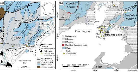
46
Pinault et al., 2004), was previously described by Albéric (2004) and Joigneaux et al. (2011) in
47
a related context of river backflooding into karst springs.
48
The factors responsible for initiating and terminating inversac events are not particularly well
49
understood and the recovery of carbonate aquifers after a seawater intrusion is poorly described
50
(Han et al., 2015). Yet, it is necessary to understand the mechanisms controlling this
51
phenomenon, as well as the long-term impact of occasional and localized saltwater intrusions,
52
to appropriately manage the groundwater resources of such karst systems.
53
In this context, a hydraulic and geochemical study was undertaken to characterize the
54
occasional and localized saltwater intrusions into the karst aquifer of the Thau basin. More
55
specifically, our study addressed the following questions: (i) What are the hydraulic and
56
geochemical conditions in the karstic aquifer during and after an inversac event? (ii) What are
57
the triggering factors contributing to the occurrence of the inversac event? (iii)To what extent
58
is the aquifer system able to recover from an inversac event and get back to its original
59
geochemical state? (iv) What are the implications in terms of groundwater resources
60
management?
61
The Thau hydrosystem in the Balaruc-les-Bains area is an example of a karst and thermal
62
aquifer affected by occasional saltwater intrusions through a submarine spring. This complex
63
hydrologic system has been described by Aquilina et al. (1997, 2002, 2003), Doerfliger et al.
(2001) and Ladouche et al. (2001). However, the causes and extent of the impact of the saltwater
65
intrusions here remain poorly understood. The karst and thermal water resources across the
66
Thau hydrosystem are exploited both for drinking water supply and spa activities.
Balaruc-les-67
bains (Fig.1) is the largest spa in France with 55,000 visitors annually. In the past, water from
68
the Vise submarine spring was diverted to the seashore and used for aquaculture activities.
69
Additionally, the Thau lagoon supports an extensive shellfish aquaculture and fishery. Thus,
70
the economic stakes are high in this area and water use conflict has the potential to arise between
71
stakeholders during dry conditions, as a consequence of an increase in water demand, and the
72
occurrence of occasional saltwater intrusions (Chu et al., 2014; La Jeunesse et al., 2015).
73
Indeed, the karst system has been affected by six inversac events through the Vise submarine
74
spring over the past 50 years (Table 1), five of which (1967,1983, 2008, 2010 and 2014) have
75
been documented and described (Ladouche et al., 2011, 2019; Ladouche and Lamotte, 2015).
76
Human activities, such as bauxite mining upstream from the Vise spring, and intervention on
77
the spring itself are thought to have contributed to the saltwater intrusions over the 1967-1993
78
period by drawing down the hydraulic head of the karst system. Historically, these inversac
79
events produced an increase in the water level and electrical conductivity at the observation
80
points (thermal well and spring) in the Balaruc peninsula. A better understanding of this
81
phenomenon is for local use purposes, but is also of strategic importance for water managers of
82
the Issanka karst spring, a major drinking water supply in the area.
83
The last two inversac events in 2010 and 2014 lasted seven and five months, respectively. The
84
2014 inversac event led to the permanent abandonment of the Cauvy spring which provided
85
drinking water to a local population of 30,000.
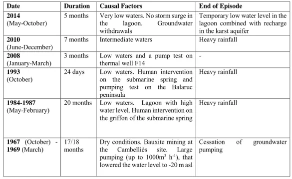
86 87 88 89 90 91 92 93 94
Date Duration Causal Factors End of Episode 2014
(May-October) 5 months Very low waters. No storm surge in the lagoon. Groundwater withdrawals
Temporary low water level in the lagoon combined with recharge in the karst aquifer
2010
(June-December) 7 months Intermediate waters Heavy rainfall 2008
(January-March) 3 months Low waters and a pump test on thermal well F14 - 1993
(October) 24 days Low waters. Human intervention on the submarine spring and pumping test on the Balaruc peninsula
Heavy rainfall
1984-1987
(May-February) 20 months Low waters. Lagoon with high water level. Human intervention on the griffon of the submarine spring
Heavy rainfall
1967 (October) -1969 (March)
17/18
months Dry conditions. Bauxite mining at the Cambelliès site. Large pumping (up to 1000m3 h-1), that
lowered the water level to -20 m asl
Cessation of groundwater pumping
95
Table 1. Summary of the observed occasional saltwater intrusions (inversac events) in the karst
96
and thermal aquifer of the Thau basin.
97
A multi-tracer approach was followed to better define the origin and contribution of the thermal,
98
karst and saltwater end-members under different conditions. Water stable isotopes (D/H,
99
18O/16O) were used to quantify the contribution of the saltwater end-member, whereas strontium
100
isotopes (87Sr/86Sr) were used to distinguish the origin of salinity (thermal or marine). Rare
101
Earth Elements (REE) were used to establish the chemical signature of the thermal wells in a
102
reference context and to evaluate the influence of the marine signature over time. Finally, the
103
B- isotope signature (d11B) was used to trace water-rock interaction initiated during inversac
104
events.
105
2. Study Area and Geological Setting
106
The Balaruc peninsula is located along the Mediterranean coast of southernmost France, west
107
of the city of Montpellier, (Fig. 1a). The karst aquifer of the peninsula lies within the Middle
108
and Upper Jurassic carbonates that outcrop to the north in the Aumelas Causse and the Gardiole
109
Massif. These Jurassic carbonates are buried under Miocene to Plio-Quaternary deposits in the
110
eastern part of the Thau lagoon (Fig 1b). Karstification and burial of the main Jurassic aquifer
111
are the result of the geological history of the region described below.
A Mesozoic series of Triassic to Early Cretaceous age was deposited during Tethyan rifting
113
(Baudrimont and Dubois, 1977; Debrand-Passard, 1984). The Mesozoic carbonate platform
114
underwent uplift during the Mid-Cretaceous, leading to exhumation that caused erosion of the
115
Early Cretaceous series and strong karstification of the Jurassic carbonates
116
The Mesozoic series was successively deformed during the Pyrenean collision phase from
117
Upper Cretaceous to Eocene time (Arthaud and Laurent, 1995; Arthaud and Seguret, 1981;
118
Choukroune et al., 1973; Choukroune and Mattauer, 1978) and the later rifting of the Gulf of
119
Lion (Arthaud et al., 1977; Arthaud and Seguret, 1981; Benedicto et al., 1996; Maerten and
120
Séranne, 1995; Séranne, 1999; Thaler, 1962). Then, the sea level rise of the Early Miocene
121
(Burdigalian) deposited transgressive sediments across the region (Fig. 1b). The overall
122
sedimentary record associated with these Upper Cretaceous to Middle Miocene geological
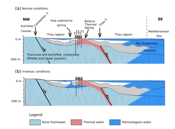
123
events, includes a wide range of detrital and carbonate facies deposited in marine, lacustrine
124
and fluvial environments (Combes, 1990; Marchand, 2019) (Fig. 1a).
125
The sea level fall related to the Messinian Salinity Crisis caused major river incision across
126
southern France which, as a consequence, deepened the karst system (Clauzon, 1982; Hsu,
127
1973; Ryan, 1976). The Messinian paleovalley in the coastal area was then flooded during the
128
early Pliocene when the Mediterranean was connected again to the Atlantic Ocean. Recent sea
129
level fluctuations over the last 5 Ma and associated Plio-Quaternary deposits have generated
130
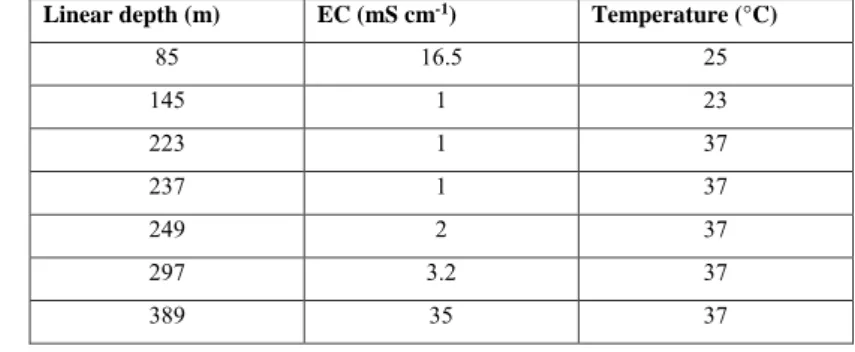
the present day morphology of the Thau lagoon.
131
Structurally, the Balaruc-les-bains area is located between both the major NE-trending
132
Cevennes and Nîmes faults, to the south of the Pyrenean Montpellier Thrust (Fig. 1a). The study
133
area is also affected by the presence of the E-W oriented Pyrenean Thau Thrust. The complex
134
fault network at the intersection with the Nîmes Fault allows to bring the Paleozoic basement
135
at shallow depth (less than 2000 m according to borehole data) in the Balaruc-Sète area (Fig.
136
1a)
138
Figure 1 (a) Simplified geological map showing the main structures of the Montpellier region. The box locates the 139
Balaruc-les-bains study area, between the Montpellier thrust and the Nîmes Fault. (b) Detailed geological map 140
of the eastern Thau lagoon. Sample sites indicated by the yellow dots in both maps correspond to the locations of 141
the thermal wells, karst springs, and other piezometric drilling sites. The location of the ancient bauxite mine 142
(Cambelliès) is indicated by the dashed oval in the northwest of the study area. 143
3. Hydrogeological conceptual model of the Thau hydrosystem
144
The Balaruc peninsula is located at the point of natural convergence of different types of
145
waters including seawater from the Thau lagoon and Mediterranean Sea, cold karst
146
groundwater sourced from the Aumelas Causse and Gardiole Massif, and mineralized hot
147
thermal water rising from depth in the Balaruc peninsula (Aquilina et al, 2002). These different
148
types of water interact together in the Middle to Upper Jurassic carbonate reservoir. The
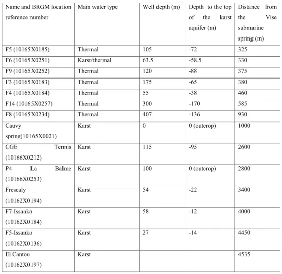
149
Montpellier Thrust to the north of the study area (Fig. 1a) brings impermeable marly Lias to
150
surface, which delimits the aquifer and acts as barrier to groundwater circulation. Groundwater
151
flow follows a general N-S trend from the Aumelas Causse and Gardiole Massif to the Balaruc
152
peninsula and the Mediterranean Sea. A clear hydraulic connection from the Vène spring
153
(Aumelas Causse) to Issanka spring (western slope of the Gardiole Massif) has been
154
demonstrated through artificial tracer testing (Paloc et Bonnet, 1969; Ladouche et al., 2001).
155
The main outlets of the Aumelas Causse karst network are the Vise submarine spring, the
156
Issanka spring and the Vène spring which acts as an overflow outlet. The Vise submarine spring
157
is located on the floor of the Thau lagoon at 30 m depth and constitutes the most downgradient
158
discharge feature of the hydrological system. The western part of the Gardiole Massif is drained
159
by the Vise spring as well as Cauvy and Ambressac springs.
At the regional scale, four levels of groundwater circulations have been recognized by previous
161
studies (Aquilina et al., 2003): 1) a surficial groundwater flow component originating from the
162
recharge areas that has a residence time <20 years; 2) an intermediate groundwater flow system
163
from the Aumelas Causse, that circulates below the Montbazin-Gigean basin and the Gardiole
164
Massif and discharges at points along the continental shelf (residence time of 50 years); 3) a
165
deep regional groundwater flow system directed from the Aumelas Causse to the Villeveyrac
166
Basin where several deep drillings (Pézenas and La Castillonne, depth of 1000 m) present hot
167
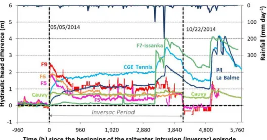
karstic waters with low mineralization (residence time of several thousand years); 4) a very
168
deep (>2 km) paleo-karst water circulation mixed with an ancient seawater circulation both
169
recharging the thermal reservoir that has residence times on the order of 100,000 years.
170
171
4. Material and methods
172
4.1 Hydrogeological Monitoring
173
Water level, specific electrical conductivity and temperature were measured at 10 locations on
174
an hourly basis during the last three inversac events in 2008, 2010 and 2014. The time-series
175
data used in this study come from the "national quantitative groundwater monitoring network
176
of the AFB/BRGM (available on the ADES website: https://ades.eaufrance.fr for P4 La Balme
177
(location 10166X0253) and CGE Tennis (location 10166X0212.) Other observation stations
178
(F5, F6, F8, F9 and S12) are managed by Balaruc-les-Bains and the municipality of Sète and
179
the Syndicat Mixte du bassin de Thau (El Cantou, F5-Issanka, Frescaly and Cauvy).
180
In order to compare the different inversac events, hydraulic head and electrical conductivity
181
were expressed with respect to reference values observed before the inversac events, as
182
discussed in the Results Section below. In Figures 3 and 5) b and 5d), the x-axis corresponds
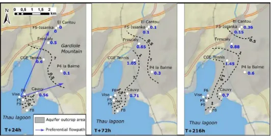
183
to the number of hours elapsed since the beginning of the inversac event (t0). The y-axis
184
represents the difference between the parameter (hydraulic head or electrical conductivity)
185
measured during the inversac and the preceding respective reference values. The variable “delta
186
H” is the difference between hydraulic head measured at time =”t” - hydraulic head observed
187
at time= t0 (before the inversac event). Thus, a positive value corresponds to an increase
188
compared to the baseline condition and vice versa. This relative comparison permits the
189
evaluation of the inversac event perturbations with respect to the initial conditions prevailing
190
in the system and result in a more precise valuation of the transient states of the system.
4.2 Geochemical and Isotopic Analysis
192
Geochemical data for the 1996-2000 period are from Aquilina et al. (2002, 2003) and Ladouche
193
et al. (2001). They are considered as representative of reference geochemical conditions of the
194
karst system. Indeed, these data were collected three to seven years after the 1993 inversac,
195
which is considered as a sufficient time for the system to have returned to its equilibrium state
196
given the short, 21-day interval of this event.
197
New geochemical data (major ions and REE compositions) and isotope analyses (D/H, 18O/16O,
198
3H, 87Sr/86Sr and d11B) were determined for samples collected in October 2010, April and
199
September of 2012 and March and August of 2018, i.e. during the 2010 inversac, 17 and 22
200
months after the end of the 2010 inversac and 3.5 years after the end of the 2014 inversac.
201
Temperature, pH, Dissolved Oxygen and Electrical Conductivity (Tref=25 °C) were
202
measured in the field, using a portable pH meter, oxymeter and conductivity meter (WTW
203
3210).
204
Water sample for major and trace element analysis were filtered on-site with disposable PP
205
syringe with a 0.22 µm Durapore membrane and stored in acid washed HDPE bottles. Aliquots
206
for cations and trace elements were acidified to pH 2 with ultrapure HNO3 (1‰ v/v). Samples
207
for H- and O-isotope analysis were collected in 15 mL amber glass vials capped with airtight
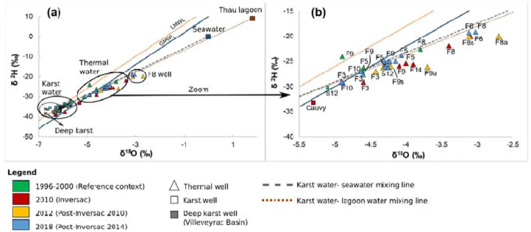
208
lids. One liter samples were collected for B- and Sr-isotope analysis in pre-cleaned HDPE
209
bottles and were later filtered in a cleanroom through a 0.22 µm Durapore membrane in a
210
pressurized Nalgene filtration unit, with samples for Sr-isotope analysis acidified with 1 %
211
ultrapure HNO3. Samples for tritium measurement were collected in 1 L HDPE bottles. All
212
samples were stored at 4 °C before analysis. Chemical analyses were performed in the
213
HydroSciences Montpellier laboratory at the University of Montpellier. Total alkalinity was
214
measured by acid titration with 0.1N HCl. Major ion (Cl-, NO3-, SO42-, Ca2+, Mg2+, Na+, and
215
K+) were analyzed by ion chromatography (ICS 1000 Dionex®). Precision error was < ± 5%.
216
After acidification with 1% HNO3-, trace elements (Li, B, Sr, REE and U) were analyzed by
217
inductively-coupled mass spectrometry using a Thermo Scientific® iCAP Q at the AETE-ISO
218
technical platform of the OSU OREME at the University of Montpellier. The use of an in-line
219
Argon Gas Dilution system permits the direct injection of highly mineralized samples without
220
prior dilution. Precision error was typically <5%. Fresh water reference material SLRS-6, and
221
seawater reference materials CASS-6 and NASS-6 for trace metals (National Research Council,
222
Canada) were analyzed every 20 samples to monitor analytical accuracy. Mean results are
within the range of certified uncertainties. Precision error for all analyses was typically <5%.
224
The REE data are represented in profiles, after normalization to a reference geological material,
225
the North American Shale Composite (NASC) for natural waters, which corresponds to an
226
average sample of North American shales (Taylor and McLennan, 1985).
227
For stable isotopes analysis, samples collected in 2010 were analyzed at BRGM Laboratories
228
using a Finnigan MAT 252 mass spectrometer, whereas those collected in 2012 and 2018 were
229
measured on an Elementar Isoprime stable isotope mass spectrometer at the LAMA laboratory
230
of HydroSciences Montpellier at the University of Montpellier. Calibration was performed by
231
repeated analyses of in-house standards of known isotopic composition in alternation with
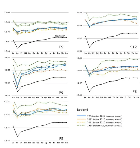
232
samples. Oxygen (18O/16O) and hydrogen (D/H) isotope ratio measurements are expressed in
233
parts per thousand (i.e. ‰) in the familiar δ notation relative to the Vienna Standard Mean
234
Ocean Water (SMOW) standard, where δ= ([Rsample/Rstandard -1] x 1000). Samples analyzed by
235
BRGM have a precision of ±0.8 ‰ for δD values and ±0.1 ‰ for δ18O values, whereas those
236
determined at the University of Montpellier have an overall precision of ± 0.6 ‰ for both δD
237
and δ18O values. Tritium analyses were performed at Hydrogeology laboratory at the Avignon
238
and Pays du Vaucluse University.
239
Sr-isotope analyses were made by thermal ionization mass spectrometry, at the BRGM
240
Laboratories for the 2010 samples and at the Centre de Recherches Pétrographiques et
241
Géochimiques in Nancy for the 2012 samples. Chemical separation of Sr was done using a
Sr-242
Spec ion-exchange column that has a total blank <0.5 ng for the entire chemical separation
243
procedure. Around 150 ng of purified Sr was loaded onto a tungsten filament and analyzed with
244
an average internal precision of ±10.10−6 (2σ) using a Finnigan MAT262 multiple collector
245
thermal ionization mass spectrometer. Measured 87Sr/86Sr ratios were normalized to a 86Sr/88Sr
246
ratio of 0.1194. The reproducibility of 87Sr/86Sr ratio measurements was tested through replicate
247
analyses of the NBS987 standard (0.710240) for which the mean value was 0.710232 ± 22x10−6
248
at the BRGM and 0.710262 ± 13x10−6 at the CRPG.
249
Boron isotopic ratios were measured with a Neptune+, Thermo Electron inductively-coupled
250
mass spectrometer (at the BRGM laboratories for samples collected in 2010 (Guerrot et al.,
251
2011) and at the AETE-ISO technical platform of the OSU OREME at University of
252
Montpellier for the other samples. The average value determined for the NIST SRM 951
253
standard was 4.67 ± 0.0033.
254
5. Results
256
5.1 Revised Conceptual Model for the Thau hydrosystem
257
The conceptual hydrogeological model of the Thau system at the local scale of the
Balaruc-les-258
Bains peninsula, is summarized in Figure 2. Thermal waters rise from the deep reservoir along
259
inferred faults in the vicinity of the Balaruc peninsula to reach the top of the Jurassic aquifer.
260
Consistent with the recent data compilation and results acquired in the Balaruc-les-Bains area
261
by the Dem’eaux Thau project (Ladouche et al., 2019), we propose that the Thau Thrust is
262
likely to provide the main pathway for thermal water. The karst freshwater is found below this
263
thermal lens as these cold waters are more dense. The diffuse intrusion of marine waters from
264
the Mediterranean Sea into the Jurassic limestone corresponds to a saltwater wedge and is
265
located below the karst waters which have a lower density. This saltwater wedge can
266
nevertheless have a more complex geometry than that represented in Fig. 2, since this
267
heterogeneous karst system is made up of multiple compartments. These contrasts in water
268
density generate several hydraulic interfaces that change according to the different hydraulic
269
heads resulting from continually- varying lagoon water levels, groundwater withdrawals and
270
recharge from precipitation.
271
272
Linear depth (m) EC (mS cm-1) Temperature (°C)
85 16.5 25 145 1 23 223 1 37 237 1 37 249 2 37 297 3.2 37 389 35 37 273
Table 2 Water temperature and electrical conductivity from the exploratory drilling F13
274
at different depths. This inclined well (40°NW, N320°) is located near the F14 well (Fig.1b)
275
This hydrogeological setting illustrated in Figure 2 was confirmed by the F13 exploratory well
276
(Table 2), that displayed contrasting electrical conductivity and temperature over depth.
277
Under normal hydrologic conditions (Fig. 2a), groundwater from the karst aquifer discharges
278
into the Vise spring, creating a plume of freshwater in the lagoon. During an occasional episode
of saltwater intrusion (or “inversac” event), the natural flow is reversed and saltwater from the
280
Thau lagoon flows into the Vise spring and enters the karstic aquifer via the Miocene cover
281
(Fig. 2b). The equilibrium between the different water bodies inside the Jurassic reservoir is
282
then strongly disrupted and the outflow of the karstic system through the Vise spring is
283
prevented. The characteristics of the thermal and karstic wells and spring in the
Balaruc-les-284
Bains peninsula are shown in Table 3
285
286
Figure 2: Conceptual cross-section oriented NW-SE passing through thermal wells of the Balaruc peninsula, and 287
showing groundwater flows of the karst hydrosystem under (a) normal conditions and (b) inversac conditions. 288
Location of the cross-section is indicated in Figure 1a. 289 290 291 292 293 294
Name and BRGM location reference number
Main water type Well depth (m) Depth to the top of the karst aquifer (m) Distance from the Vise submarine spring (m) F5 (10165X0185) Thermal 105 -72 325 F6 (10165X0251) Karst/thermal 63.5 -58.5 330 F9 (10165X0252) Thermal 120 -88 375 F3 (10165X0183) Thermal 175 -65 380 F4 (10165X0184) Thermal 55 -38 460 F14 (10165X0257) Thermal 300 -170 585 F8 (10165X0234) Thermal 407 -136 930 Cauvy spring(10165X0021) Karst 0 0 (outcrop) 1000 CGE Tennis (10166X0212) Karst 115 -95 2600 P4 La Balme (10166X0253) Karst 100 0 (outcrop) 2800 Frescaly (10162X0194) Karst 54 -22 3400 F7-Issanka (10162X0184) Karst 58 -12 4000 F5-Issanka (10162X0136) Karst 27 -14 4450 El Cantou (10162X0197) Karst 4535 295
Table 3 Characteristics of the main wells and springs in the study area
296
297
5.2 Hydraulic impact of the inversac event
298
This section provides a detailed hydrodynamic analysis of the most recent inversac event in
299
2014 and then makes a comparison between the last three inversac events of 2008, 2010, and
300
2014.
301
The hydraulic impact of the inversac event of 2014 was observed at all Balaruc peninsula
302
springs and observation wells (Fig.3). From the first hours after the intrusion of lagoon water,
303
a sharp increase in water level is observed for both karst and thermal wells, although the impact
304
is variable for different locations. The hydraulic impact was most significant for thermal well
F9, for which a +2.2 m increase in hydraulic head was observed during the first four days of
306
the inversac event. The magnitude of the hydraulic impact is similar for F5 and F6 wells, with
307
experienced respective increases in hydraulic head of +1.8 m and +1.9 m respectively. A lower
308
increase in hydraulic head of just +0.7 m during the first four days of the inversac event was
309
recorded at the Cauvy spring, situated only 1 km from the Vise submarine spring. For this
310
spring, the increase is also partly caused by the interruption of water pumping. The hydraulic
311
disturbance gradually increases over a 3-months period for the CGE Tennis and P4 La Balme
312
wells, reaching a maximum of 2 m at CGE and around 1 m at P4 La Balme piezometers after
313
1,500 h.
314
Two large rainfall events occurred in September and October 2014, some 3,400 h after the
315
beginning of the inversac event. These resulted in recharge to the aquifer that caused a sharp
316
increase in well water levels of +1.3 m at CGE Tennis and +1 m, at P4 La Balme.
317
The end of the inversac event occurred in October during the normal recession period of the
318
groundwater levels across the region. The thermal wells experienced a rapid decrease of
319
hydraulic head, which contrasted with the slow decrease of water levels in the CGE Tennis, P4
320
La Balme and F7-Issanka wells. After the inversac event, the water levels in CGE Tennis, P4
321
La Balme and Cauvy spring were observed in an intermediate position between the maximum
322
inversac and reference levels. In addition, the analysis of the water levels in the Thau lagoon
323
by Ladouche and Lamotte (2015) indicates that the end of the 2014 inversac resulted from
324
strong Tramontane winds caused an abrupt decrease in the lagoon water level in the vicinity of
325
the Vise submarine spring. Thus, both a temporary condition of a low water level in the Thau
326
lagoon and high waters conditions in the karst aquifer following heavy rainfall events appear to
327
have contributed to the conclusion of the 2014 inversac event.
328
In the Villeveyrac Basin area, the evolution of piezometric levels during 2014 indicates that the
329
hydrology of this region was not affected by the inversac event (Ladouche and Lamotte, 2015).
330
The elevated piezometric level of some 70 m here compared to the Vène area (3 m) strongly
331
suggests a compartmentalization of the karst aquifer.
332
333
335
Figure 3 Evolution of variations in hydraulic head (m) of wells and springs across the study area during the 2014 336
inversac event. The rainfall record during this time is shown at the top of the figure. 337
338
Figure 4 illustrates the dynamics of the hydraulic disturbance to the karst system caused by the
339
2014 inversac event across the Balaruc-les-Bains peninsula. This detailed analysis demonstrates
340
the hydrologic connection between the Vise spring and the Issanka area. This perturbation
341
propagates rapidly and reaches a distance of 3 km upgradient in less than 24 h (i.e. a velocity
342
of 125 m h-1). More specifically, the inversac causes an increase in hydraulic head of +1.5 m
343
throughout the peninsula and +0.5 m to the north of the peninsula (Frescaly, CGE Tennis) in
344
the first 24 h. This hydraulic perturbation then reaches the Issanka area in less than 72 h (i.e. a
345
velocity of 69m h-1) and causes a +0.4 m increase in hydraulic head within 10 days.
346
In addition, Fig.4 clearly shows that the hydraulic perturbation follows a preferential pathway
347
with a NNE orientation. A second minor flowpath follows a ENE orientation from the Vise
348
spring towards Cauvy and Ambressac springs.
349
351
Figure 4 Spatial propagation of the hydraulic perturbation (hydraulic head increase in m) across the Balaruc-les-352
Bains peninsula during the 2014 inversac event at three times after initiation: T+24 h, T+72 h, and T+216 h. 353
354
Comparison between the 2008, 2010, and 2014 inversac events.
355
Comparison between the last three inversac events of 2008, 2010, and 2014 provides a basis
356
for examining the hydraulic response to the phenomenon under different hydrological states.
357
The 2008 inversac caused an increase in the hydraulic heads of all the wells and piezometers in
358
the study area. For example, karst wells P4 La Balme and CGE Tennis showed respective
359
increases in the hydraulic head of +2 m and +1 m.
360
The increase in the water levels reached the same wells during the 2014 inversac as in 2008,
361
but was generally lower (more than 1 m for P4 La Balme and Frescaly and about 0.4 m in the
362
Issanka area).
363
In contrast to the 2008 and 2014 events, the hydraulic impact of the 2010 inversac did not reach
364
the Issanka area. An increase in hydraulic heads ranging from 1.5 to 2 m was only observed
365
north of the Balaruc-les-Bains peninsula for the P4 La Balme and CGE Tennis wells. The
366
explanation for this observation is discussed in the Discussion section.
368
Figure 5 (a) Hydraulic head (m) and (b) hydraulic head variation (m) of the karst well P4 La Balme during the 369
2010 and 2014 inversac events; electrical conductivity variation (mS cm-1) for the thermal wells (c) F5 and (d) F9
370
during the 2008, 2010 and 2014 inversac events. 371
The hydraulic head of the karst well P4 La Balme was higher during the 2010 inversac
372
(intermediate waters) than during the 2014 inversac (very low waters) reflecting contrasted
373
hydrologic conditions during these periods (Fig.5 a). However, the hydraulic head difference,
374
with respect to the reference measured before the inversac (Fig. 5b), is higher in 2014 than in
375
2010. This suggests that the low water conditions magnify the hydraulic impact of inversac
376
events. Similarly, electrical conductivity differences for the thermal wells F5 (Fig. 5c) and F9
377
(Fig. 5d) show a stronger response to the 2014 inversac than during both the 2008 and 2010
378
inversacs.
379
5.3 Geochemical impact of the inversac event
380
In addition to the hydraulic impact just described, inversac events also have a notable
381
geochemical impact on the water bodies circulating within the karst system. As indicated in the
382
discussion of the “Hydrogeological conceptual model” section, the salty and highly mineralized
383
water of the lagoon mixes with thermal and karst waters to alter their quality. A multi-tracer
384
approach was undertaken to determine the long-term hydrochemical impact of inversac events
385
on the system that employed analysis of major ion contents, REE concentrations, and H-, O-,
386
Sr- and B-isotopic compositions. The geochemical analyses reflect contrasting conditions: the
1996-2000 reference interval, the 2010 inversac event, and the 2012 and 2018 post-inversac
388
period.
389 390
Groundwater characteristics- Major ions and water types
391
Outside of the Balaruc Peninsula, karst groundwater from Issanka spring and Pézenas deep
392
borehole (738 m) is of a Ca-Mg-HCO3 type, characterized by electrical conductivity (EC)
393
values of about 500 μS cm-1, in agreement with their karstic water type. The water from the
394
deep borehole has a higher temperature (37.2 °C) than that of the Issanka spring (about 17.5
395
°C).
396
Within the Balaruc peninsula, karst water from the Cauvy spring is of the same water type, but
397
displays elevated Cl contents and EC values of up to 222 mg L-1 and 1200 μS cm-1, respectively.
398
In contrast, the thermal waters with temperatures that range up to 49.9°C are of a Na-Cl type
399
with Cl concentrations of up to 7,900 mg L-1. The Ambressac spring, located east of the Balaruc
400
peninsula, is of mixed water type, with higher Cl concentration than at the Cauvy spring (up to
401
930 mg L-1). Some samples also have high sulfate concentrations that approach 585 mg L-1.
402
The Cauvy spring and the thermal wells F5, F6, and F9 were the most impacted by the 2010
403
inversac event, displaying a sharp increase of conductivity as well as high contents of Cl and
404
Na. For example, Cl concentrations in the Cauvy spring and F6 reached levels 8 to 11 times
405
above values typical of normal flow conditions (i.e. 1,240 mg L-1 compared with 157 mg L-1 for
406
Cauvy and 8611 mg L-1 compare with 759 mg L-1 for F6). For the Cauvy spring, which is used
407
for potable water, this Cl content observed during the inversac event far exceeds the drinking
408
water standard of 250 mg L-1.
409
In a post-inversac context, Cl and Na concentrations observed for the Cauvy spring and F5, F6
410
and F9 wells in 2012 decreased significantly, with waters at these sampling points having
411
returned to levels close to those of the 1996-2000 reference period. By contrast, Cl
412
concentrations in wells F8 and F3 increased between 2010 and 2012, suggesting an increase in
413
the relative contribution of the marine water component.
414 415
Karst water and saltwater mixing traced by water stable isotopes
416
As shown in Figure 6a, different waters present in the Balaruc peninsula hydrosystem are
417
characterized by distinct δD and δ18O values. Normal waters within the karst system lie close
418
to the Local Meteoric Water Line (δD = 8 δ18O+14; Ladouche et al., 1998), illustrating their
meteoric origin. Waters sampled from thermal wells are more enriched in D and 18O than the
420
karst waters and are distributed along a karst-saltwater (i.e. lagoon or seawater) mixing line.
421
This result indicates that thermal waters result from a mixing between karst and marine
end-422
members. However, stable isotopes information alone does not allow a determination of the
423
origin of the marine end-member, which could be either lagoon water or modern or ancient
424
seawater. Samples from the F8 thermal well show a slightly enriched stable isotopes signature
425
compared to the other thermal wells, reflecting a greater contribution of the saltwater
end-426
member in this area, as initially indicated by Aquilina et al. (2002).
427
F6 samples from the reference period are located within the karst water domain, confirming the
428
strong influence of karst waters in this well (Aquilina et al. 2002) under normal flow conditions.
429
H- and O-isotopic signatures of groundwater from F5, F9, F8 and F6 thermal wells are shifted
430
towards the saltwater end-member during the 2010 inversac. Then, in 2012 and 2018, their δD
431
and δ18O values decreased, but still remain in an intermediate position between the inversac
432
maximum and the reference (1996-2000) period minimum. This result raises the question of
433
the persistence of the chemical impact in the aquifer system following occasional saltwater
434
intrusions.
435
Thermal wells F14, F5 and the thermal spring S12show similar mixing proportions for the
436
2012 and 2018 post-inversac times. For F5 and S12, these mixing proportions are intermediate
437
between that of the 2010 inversac event and the 1996-2000 reference time. Groundwater
438
samples of F3 well do not follow the same evolution, as the shift in its δ18O value does not
439
appear inversac related (Fig. 6b).
441
Figure 6 H- and O-isotopic compositions, expressed as δD and δ18O values, of (a) karst waters, thermal waters,
442
F8 well water, seawater, and Thau lagoon water, showing the Global Meteoric Water Line (GMWL) after Craig 443
(1961) and the Local Meteoric Water Line (Ladouche et al., 1998 ) for reference; (b) expanded view of the thermal 444
well water array from (a) during reference, inversac, and post-inversac conditions 445
446
Two end-member mixing calculations were made to model the geochemical impact of the 2010
447
inversac event on waters at the different sampling points across the study area, the first based
448
on stable isotope ratios and the second using Cl concentrations measured in 2010, 2012, and
449
2018. The proportions of karst water (ffresh) and saltwater (fsalt) in a groundwater sample were
450
calculated using the following formula:
451 𝑓𝑠𝑎𝑙𝑡= 𝐶𝑠𝑎𝑚𝑝𝑙𝑒−𝐶𝑓𝑟𝑒𝑠ℎ 𝐶𝑠𝑎𝑙𝑡−𝐶𝑓𝑟𝑒𝑠ℎ equation 1 452 𝑓𝑠𝑎𝑙𝑡+ 𝑓𝑓𝑟𝑒𝑠ℎ= 1 equation 2 453 454
Results of the mixing calculations are included in the Supplement (Table S1). This calculation
455
gives an indication of the magnitude of the karst water and saltwater component in of each
456
water sample, but does not provide additional insight into the origin of groundwater salinity.
457
The calculated fractions of saltwater for the karst wells and spring are similar for the three
458
tracers (δ18O, δD and Cl). However, for thermal wells with typical high Cl contents, the
459
fractions obtained are distinct for the different tracers, indicating another source of Cl for these
460
wells. Indeed, as indicated by Aquilina et al. (2002), Cl in the thermal wells is thought to derive
461
from both seawater and the thermal water end-member, which is itself partly constituted of old
462
seawater.
Inversac persistence revealed by REE
464
The 14 members of the lanthanide group of elements (from La to Lu), commonly termed rare
465
earth elements (REE), constitute an effective tool to trace water origin, water/rock interaction
466
and mixing processes (Johannesson et al. 1997, Tweed et al. 2006, Zhan et al. 2013, Gil et al.
467
2018). The REE are naturally present in natural waters at trace concentrations and their
468
normalized abundances, represented as a distribution pattern of individual REE ordered by their
469
atomic number, provide a means of visualizing the behaviour of the entire group of elements.
470
The REE profiles for seawater and groundwater from the thermal wells (S12, F8, F9, F5, F6)
471
and seawater are shown in Figure 7 for the pre-inversac reference and three post-inversac
472
situations (Fig. 7). With the exception of the F6 well, all patterns are generally flat and show a
473
small negative Ce anomaly. The F6 profile exhibits a more pronounced Ce anomaly and an
474
enrichment in heavy REE. These characteristics are those of limestone REE profiles, inherited
475
from the seawater REE profile and confirm the strong karst influence of F6 samples.
477
Figure 7 REE profiles for thermal wells at different times: the 1998 data are for the pre-inversac reference state, 478
whereas the 2011, 2012 and 2018 profiles are for the three post-inversac situations. 479
480
REE contents during the 2011-2012 post-inversac period were generally lower than for the 1998
481
reference context. This is to say that, REE profiles in a post-inversac context lie in an
482
intermediate position between the seawater profile and the reference profiles. Such an
483
observation indicates that the thermal wells, at the time of sampling 20 months later in 2012,
484
were still under the influence of the perturbations caused by the 2010 inversac event. The
post-485
inversac profiles for 2012 and 2018 are quite similar, except for the F6 well, suggesting a
486
similarity in extent of the 2010 and 2014 inversac events and post-event response of the
487
hydrologic system. The REE profile for the F8 thermal well displays a distinctly different
488
is not hydraulically impacted by the occasional saltwater intrusion. The observed evolution does
490
not seem related to an increase in water withdrawals, but may instead reflect a relative decrease
491
in the contribution of thermal component over time.
492
Characterization of the thermal and marine contributions from the strontium isotope
493
ratios 87Sr/86Sr
494
Consideration of strontium geochemistry allow the characterization of the thermal and marine
495
water contributions to the karst groundwaters. Sr-isotope ratios (87Sr/86Sr) for the groundwater
496
and lagoon samples are plotted as a function of strontium in Figure 8, where the 2010 and 2012
497
post-inversac data are compared with the 1996-2000 reference situation. It was assumed that
498
the waters from the F5 thermal well in the Balaruc peninsula during the reference interval are
499
representative of the thermal end-member, which is not affected by the karst or marine waters.
500
It is notable of the Sr-isotopic signature and Sr content of the CGE Tennis samples are relatively
501
stable in all contexts and fully representative of karst waters under confined conditions. The
502
Thau lagoon water sample is compositionally similar to that of the Mediterranean Sea and
503
corresponds to the saltwater end-member. The 87Sr/86Sr isotopic signature of karst waters and
504
thermal end-member are similar, indicative of derivation through water-rock interaction with
505
the Mesozoic carbonate aquifer. The karst member is different from the thermal
end-506
member by its lower Sr concentrations (100 µg L-1), suggesting different water residence times.
507
As shown in Fig.8, all water samples plot within a ternary domain, confirming that the
508
geochemistry from the Balaruc peninsula groundwater can be explained by a 3-member mixing.
509
The karst waters from the Issanka spring that drain the Aumelas Massif have a lower 87Sr/86Sr
510
ratios and Sr contents. The Issanka isotopic signature defines an up-gradient end-member for
511
the karst system, unaffected by mixings of the thermal and seawater that characterizes the
512
Balaruc peninsula. Waters from the P4 La Balme piezometer had a very high 87Sr/86Sr ratio in
513
2012, almost certainly reflecting the influence of rainfall infiltration since this sample site is
514
located at the outcrop of the aquifer and may be representative of surficial recharge water to the
515
karst aquifer.
517
518
Figure 8 Plot of 87Sr/86Sr ratio versus Sr concentration (as 1/Sr) for springs and wells of the Balaruc peninsula
519
for different hydrogeological situations: pre-inversac reference (green), 2010 inversac (red) and 2012 post-520
inversac (yellow). 521
522
The contribution of each end-member (saltwater, thermal water and karst water) to groundwater
523
samples under different hydrogeological situations related to inversac events were estimated
524
through 3-component mass balance equations following Faure (1986):
525
𝑓𝑠𝑎𝑙𝑡+ 𝑓𝑘𝑎𝑟𝑠𝑡+ 𝑓𝑡ℎ𝑒𝑟𝑚= 1 equation 3
526
where:
527
(87Sr/86Sr)*[Sr]sample= fsalt (87Sr/86Sr)*[Sr]salt+fkarst (87Sr/86Sr)*[Sr]karst+ ftherm(87Sr/86Sr)*[Sr]therm
528
Results of the mixing calculations are in the Supplement (Table S2).
529
The Sr-isotopic composition of the Cauvy spring is quite variable during the reference interval,
530
with samples aligned along the karst-saltwater mixing line in Figure 8. The contribution of the
531
saltwater end-member to the spring discharge is negligible under normal flow conditions, with
the Cauvy isotopic signature very close (99%) to the karst end-member. However, the Cauvy
533
spring is strongly impacted by the inversac phenomenon. Although he karst end-member
534
remains dominant at 88.1 ± 0.2 %, the contribution of saltwater end-member increases to 8.1 ±
535
0.5 % and that of the thermal end-member reaches about 3.8 ± 0.3 % during the 2010 inversac
536
event. The contribution of thermal waters to the Cauvy spring is not surprising, as it is located
537
close to the old thermal spring (S12), but the large contribution of the saltwater end-member
538
during inversac events implies a preferential groundwater flow axis between the spring and the
539
Vise submarine spring. Pinault et al. (2004) have shown that variations in the contribution of
540
thermal waters may be related to the existence of a piston effect on the thermal reservoir,
541
particularly following an intense recharge event.
542
Thermal well waters of the Balaruc peninsula are all aligned along the thermal-saltwater
end-543
member mixing line in Figure 8, except for F3, F4 hotel, and F6 waters, each of which
544
documents a significant contribution from the karst end-member (87.9 ± 0.3 %, 89.8 ± 0.2 %
545
and 53.7 ± 0.6 %, respectively).
546
The evolution of the isotopic signature for the F5, F9 and F14 borehole waters shows a similar
547
pattern. Thermal water 87Sr/86Sr ratios increase during the 2010 inversac event, but then
548
decreases in 2012 to values intermediate between the inversac condition and normal state. These
549
observations suggest that waters from this group of thermal wells were strongly affected by the
550
2010 inversac had not returned to their 1996-2000 pre-inversac Sr-isotope signature by the 2012
551
post-inversac situation.
552
The contribution of the Thau Lagoon end-member increased to 8.3 ± 1.3 % for the F9 waters
553
during the 2010 inversac, the thermal end-member was 91.3 ± 0.6 %, the karstic contribution
554
being negligible (0.4 ± 1.9 %). The contribution of the Thau lagoon end-member decreased to
555
5.7 ± 1.2 % during the 2012 context.
556
Reporting on water collected from the F8 borehole, Aquilina et al. (2002) noted a seawater
557
contribution to the thermal waters in this area of the Balaruc peninsula, which we have
558
estimated to be 8.8 ± 1.3 % for the 1996-2000 pre-inversac reference period.
559
The strontium concentrations and 87Sr/86Sr ratios of F8 well waters were very similar in 2010
560
and in April and September of 2012. Although the contribution from the saltwater end-member
561
during the 2010 inversac was greater than the reference condition (18.0 ± 1.6 % instead of 8.8
562
± 1.3 %), and remained between 17.5 ± 1.6 % to 21.2 ± 1.8 % from April to September 2012.
563
The thermal well F8 does not seem to be impacted by a direct intrusion of lagoon water during
564
the inversac event but instead influenced by seawater already within the hydrosystem.
Water at the F6 borehole was the most impacted by the 2010 inversac. During this time, the
566
contribution from the saltwater end-member sharply increased from 1.6 ± 0.1 % to 35.4 ± 1.8
567
% between 1996 to 2010 then decreased to 0.6 ± 0.1 % in 2012, a value below the 1996 to 2000
568
reference interval. Waters from the F6 borehole are representative of the upper part of the
569
Jurassic aquifer and demonstrate a significant contribution of the karst end-member (94.1 ± 0.1
570
% to 91.2 ± 0.2 % in 1996 and 2012). This karst contribution remains significant during an
571
inversac context (53.7 ± 0.6 %). Thus, waters from the F6 well illustrate the range of
572
fluctuations of the thermal component.
573
By contrast to the F6 well, the three end-member contributions are relatively stable for the
574
waters of Ambressac spring. Indeed, water samples display a large variability, with a saltwater
575
end-member contribution of between 1.1 ± 0.1 % and 2.7 ± 0.2 % and a karst contribution
576
between 94.4 ± 0.1 % and 91.5 ± 0.1 % over the reference interval (1996-2000). The thermal
577
contribution ranges between 4.4 ± 0.1 % and 5.8 ± 0.2 % during normal times.
578 579
Boron Isotope Tracking of Water-rock interactions
580
A lack of knowledge of the baseline B-isotopic signature during normal flow conditions does
581
not allow to discuss the origin of boron and its quantification for thermal borehole waters.
582
However, examination of δ11B variations as a function of B/Cl ratio clearly identifies water
583
interactions with clay minerals. Indeed, boron is present in aqueous solution, in the form of
584
boric acid B(OH)3 and borate ions B(OH)-4. The distribution between these two species depends
585
on pH, temperature and salinity (Hershey et al 1986, Hakihana 1977). For the boron isotopes,
586
11B is preferentially incorporated into boric acid whereas 10B has a greater affinity for the borate
587
ion. During the water-rock interaction, B(OH)-4 will be preferentially adsorbed onto clay
588
minerals or organic matter, resulting in a decrease of water B concentration and a consequent
589
enrichment of 11B in residual water.
590
Figure 9 shows the Cl/B ratio as a function of B isotopic composition. δ11B of the Thau Lagoon
591
is 39.1 ‰, in agreement with the signature of the modern seawater of 39.5 ‰; (Aggarwal et al.,
592
2004, Aggarwal and Palmer 1995). By contrast, karst waters display a range of δ11B values
593
from 23.1 to 52.3 ‰, but are strongly 10B enriched relative to seawater signature, whereas,
594
thermal waters have δ11B values of up to 44.3 ‰ that are similar to or higher than the seawater
595
signature.
There is a good alignment of the data points in Fig. 9, which illustrates the process of water/rock
597
interaction and indicates that the B in the waters across the Balaruc peninsula is derived from
598
clay sediments. That 11B/10B ratios are well above the seawater values, suggests that water
599
from the Thau lagoon interacts with clay sediments within the karst system during the
600
occasional intrusion into the carbonate aquifer.An exploration dive of the bottom of the Vise
601
spring in April 2017 showed the absence of sediment on the walls and bottom of the spring.
602
The inversac phenomenon therefore seems to be accompanied by a significant intrusion of
603
sediments (clayey marine mud, rich in organic matter). This phenomenon seems to contribute
604
to initiate the process of boron isotope fractionation. This process could also occur within the
605
silty-clay Miocene unit during the transfer of water from the lagoon to the Jurassic aquifer. This
606
Miocene formation overlies the Jurassic aquifer and is about 30 m thick at the Vise spring. The
607
high isotopic enrichment observed for the F3 borehole waters can be explained by their high
608
pH values (8.3) and thus a relatively higher proportion of the B(OH)-4 species, leading to a
609
higher adsorption on the solid phase and a higher enrichment of δ11B of the residual water.
610
Boron isotopes are used to identify the chemical modification of the water that enters the system
611
and interacts with the clay matrix. There is therefore a modification of the water chemistry
612
before it even enters the karst aquifer, and this modification is initiated during the saltwater
613
intrusion.
614
615
Figure 9. Plot of δ11B versus Cl/B ratio for different hydrogeological contexts: 2010 (inversac times in red),
617
2012 and 2018 (post-inversac times in yellow and blue) 618
619
6. Discussion
620
6.1 Implications for Dynamics of the Thau hydrosystem
621
Extent of the hydraulic impact and conditions required to reach the upgradient area of
622
Issanka
623
Analysis of the hydraulic response of the Thau hydrosystem to the last inversac events provides
624
insights into the dynamics of the system and a better understanding of the underlying controlling
625
mechanisms. For example, the 2010 inversac did not impact the upgradient area of Issanka in
626
contrast to the 2008 and 2014 inversac events. This is attributed to the fact that the karst system
627
in 2010 was less in deficit than at the time of the 2008 and 2014 events, when very low flow
628
conditions prevailed. For example, piezometric levels measured for the Issanka area in 2008
629
and 2014 were lower than in 2010 (i.e. 6.82 m in 2008 and, 6.89 m in 2014 and, 9.33 m in
630
2010). Considering that the overflow level of the Issanka spring is at ~9.5 m, this implies that
631
the hydraulic impact in the Issanka compartment is controlled by the pressure head difference
632
between the upstream (Issanka) and downstream (Balaruc peninsula) compartments.
633
Piezometric monitoring at these different times illustrates that the occurrence of the inversac
634
phenomenon is mainly determined by hydrogeological processes that occur within the
635
downstream compartment of the karst system. Water level of the Thau lagoon is one of the
636
controlling parameters. At inversac initiation in 2008, the water level in the Thau lagoon was
637
higher than in 2010 at 1 m compared to just 0.5 m, but then only of 0.2 m in 2014. For the
638
inversacs of 2008 and 2010, the sudden rise in lagoon waters of + 0.5 m and + 0.4 m,
639
respectively, in a few hours is considered to be
640
the triggering factor. By contrast, no sudden change in the water level of lagoon was observed
641
in 2014. The triggering mechanism of this event is still poorly understood, however it is likely
642
that the withdrawals from the aquifer for drinking water and irrigation purposes as well as the
643
low recharge during the previous winter may be the explanatory factors.
644
Thus, two factors would need to be combined for an inversac to reach the upgradient area of
645
Issanka: (i) first, low water conditions that produces a very low hydraulic head throughout the
646
aquifer. The hydraulic head would need to be lower than 7 m in the Issanka area, i.e. below
647
than the hydraulic head imposed by the saltwater intrusion; (ii) an event-specific triggering
mechanism, such as a sudden rise in the water level of the Thau lagoon or groundwater
649
withdrawals.
650
The intrusion of lagoon waters in the system causes a 2-phase response within the Thau
651
hydrosystem:
652
1) A short initial transient phase of a few days duration during which there is a
653
reorganization or displacement of the different karst, thermal and marine water bodies
654
within the hydrosystem,
655
2) A longer transient phase during which the hydrosystem reaches a new equilibrium (in
656
30 days in 2008 and 2010, 40 days in 2014) with clear evidence of water mixing causing
657
important changes in the physico-chemical parameters of waters from the sampling
658
points F5, F6, F9 and the Cauvy spring.
659 660
The impact on water quality is local whereas the hydraulic impact is perceived at the
661
regional scale
662
Results in section 5.1 showed that the hydraulic impact of an inversac event is instantly
663
propagated throughout the Balaruc peninsula and the effects of such events can also reach
664
longer distances into the karst system than previously described. The return to the equilibrium
665
situation occurs within days after a significant recharge event and is much more rapid than the
666
dissipation of the chemical impact of the inversac event. Indeed, the 2010 and 2014 inversac
667
events lasted about 6 months and had a persistent chemical impact on the hydrosystem. It stayed
668
perceptible on the quality of the water in certain compartments from 20 months to 42 months
669
after the occasional inversac intrusions ceased.
670
Even though the geochemical conditions within the hydrosystem were not monitored during
671
the 2014 inversac event, the 2018 data are similar to those for 2012, suggesting that the
672
hydrosystem did not reach its geochemical reference conditions and was still under a state of
673
influence by the latest inversac event.
674
Geochemical analysis indicates that the 2010 inversac had the greatest impact on waters from
675
the F6 well and the Cauvy spring, thus confirming the existence of a preferential groundwater
676
flowpath between the Vise spring and those points.
677
The physico-chemical disturbances resulting from inversac event are not observed at sampling
678
points CGE Tennis, P4 La Balme, Issanka located in the upgradient area of the Balaruc
peninsula. The geochemical impact is, therefore, restricted to within a 1-kilometer radius from
680
the Vise spring (Fig. 10).
681
This slow geochemical recovery is best explained by the characteristic internal heterogeneity
682
of the karst aquifer, which is typically described in terms of a triple porosity model comprising:
683
(i) matrix or primary porosity, (ii) fracture porosity and (iii) conduit porosity (Palmer et al 1999;
684
Martin and Screaton 2001). Influx of inversac water into the matrix porosity of the karst aquifer,
685
its storage, and then prolonged time of removal and return to fracture and conduit flow explains
686
the persistent fingerprint of the saltwater intrusions in the Balaruc peninsula.
687
Wells F8 and F10 in the southern part of the Balaruc peninsula were not affected by the inversac
688
events. This part of the hydrosystem corresponds to a deeper compartment in the karst system,
689
where the top of the Jurassic aquifer is 136 m deep in the F8 well and 195 m deep in the F10
690
well, which appears to be less hydraulically connected to the rest of the peninsula. Previous
691
studies postulated that an indirect impact of an inversac event might occur (Ladouche et al.,
692
2012). However, the increasing mineralization of F8 waters over time from 20 mS cm-1 in 1996
693
to 26.5 mS cm-1 in 2018 (Figure S1 in the Supplement) suggests that waters from this well are
694
not influenced by the occasional saltwater intrusions into the hydrosystem. This distinct
695
evolution cannot be explained by pumping withdrawals as well withdrawals rates in the F8
696
thermal well were steady over the period of inversac monitoring. However, a decrease in the
697
recharge rate from the karst system could result in an increase in the proportion of the thermal
698
or marine end-member contributions. Recent monitoring of springs (Ambressac and S12) will
699
address this question in the Dem'Eaux Thau project.
700
A comprehensive review of historical inversac events undertaken as part of this study showed
701
that there is a hydraulic connection between the Villeveyrac Basin and the Balaruc peninsula.
702
The relationship between these two regions is clearly demonstrated as dewatering of a bauxite
703
mine in the Cambelliès area (Fig.1) triggered the 1967 inversac event.