HAL Id: hal-00739084
https://hal-brgm.archives-ouvertes.fr/hal-00739084
Submitted on 5 Oct 2012
HAL is a multi-disciplinary open access
archive for the deposit and dissemination of sci-entific research documents, whether they are pub-lished or not. The documents may come from teaching and research institutions in France or abroad, or from public or private research centers.
L’archive ouverte pluridisciplinaire HAL, est destinée au dépôt et à la diffusion de documents scientifiques de niveau recherche, publiés ou non, émanant des établissements d’enseignement et de recherche français ou étrangers, des laboratoires publics ou privés.
Reconstruction of the Upper Cretaceous chalks removed
by dissolution during the Cenozoic in the western Paris
Basin
Benoît Laignel, Florence Quesnel, Robert Meyer, Chantal Bourdillon
To cite this version:
Benoît Laignel, Florence Quesnel, Robert Meyer, Chantal Bourdillon. Reconstruction of the Upper Cretaceous chalks removed by dissolution during the Cenozoic in the western Paris Basin. International Journal of Earth Sciences, Springer Verlag, 1999, 88 (3), pp.467-474. �10.1007/s005310050279�. �hal-00739084�
B. Laignel (Y) 7 F. Quesnel 7 R. Meyer
Laboratoire de Géologie, EP CNRS 1749, Université de Rouen, F-76821 Mont-Saint-Aignan, France
e-mail: Benoit.Laignel6univ-rouen.fr Tel.: c33-02-35146947
Fax: c33-02-35147022 F. Quesnel
Compagnie Générale de Géophysique, 1 Rue Léon Migaux, F-91341 Massy, France
C. Bourdillon
B.R.G.M., SGN/I2G/NDC, F-45060 Orléans Cedex, France
ORIGINAL PAPER
B. Laignel 7 F. Quesnel 7 R. Meyer 7 C. Bourdillon
Reconstruction of the Upper Cretaceous chalks removed
by dissolution during the Cenozoic in the western Paris Basin
Received: 20 July 1998 / Accepted: 1 July 1999
Abstract During the Cenozoic, in the western Paris
Basin, atmospheric weathering of the chalks with flints of the Upper Cretaceous led to the creation of clay with flints. A reconstitution of the chalks lost to dissolution is proposed and is based on the determination of the age of the parent chalks of the clay with flints and the quantification of the thickness of dissolved chalk. The chalks affected by weathering range in age from Turonian to Maastrichtian, thus confirming the deposi-tion of calcareous sediments in the western Paris Basin up to the Maastrichtian. Chalk weathering took place in situ, as indicated by the preservation of the strati-graphic succession of the chalk in the clay with flints profiles. Weathering led to the dissolution of 20–200 m of chalk, with regional variations. The weathering rate varies between 2.1 and 14.5 m/Ma.
Key words Clay with flints 7 Chalk 7 Upper
Cretaceous 7 Weathering 7 Paris Basin
Introduction
During the Cenozoic, in the northern, western and southern parts of the Paris Basin, the Aquitaine Basin and in the southern part of the London Basin, Upper Cretaceous chalks experienced atmospheric weathering
that led to the formation of clay with flints (CWF) (Brajnikov 1938; Bonte 1955; Klein 1970; Dewolf 1976, 1982; Callot and Pédro 1977a, 1977b; Catt 1986).
Some authors have attempted to quantify the thick-ness of chalk which needed to be dissolved to obtain the thickness of CWF observed presently. In 1938 Braj-nikov showed that for a CWF thickness of 30–40 m and for a proportion of insoluble material contained in the chalk of approximately 15%, decalcification of approxi-mately 200–250 m of chalk was required (6–7 m of chalk for 1 m of CWF). From the study of the Campanian chalk, Bauer (1964) proposed two esti-mates: to produce the observed clay and sand contents in 1 m of CWF, it is necessary to dissolve either 77 or 200 m of chalk. For the CWF of southern England, Jukes-Browne (1906) showed that the dissolution of 100 m of chalk of the Micraster coranguinum zone resulted in 7 m of CWF (14 m of chalk producing 1 m of CWF).
The wide ranges of these figures highlights the diffi-culty of proposing quantifications of thickness of chalks dissolved during the Cenozoic. This appears to be related in part to difficulties with the methodologies employed:
1. No detailed compilations had been undertaken on the CWF and the calculations were based on spot sampling, not only of the CWF, but also of the chalks.
2. The ages of the CWF parent chalks were poorly known, if known at all.
3. The calculations are based on either the total content of insoluble material (flint and matrix) or on the matrix alone. It has been clearly established that the flints of the CWF are derived from the chalk (Brajnikov 1938; Klein 1970). Furthermore, recent studies (Laignel 1997; Laignel et al. 1998a) have shown that the CWF is not solely the product of decalcification of the chalk: the matrix of CWF is a mix of decalcification residue of the chalk and allochthonous inputs (Cenozoic clay, silt and sand deposits). Thus, it appears preferable to base the
468
calculations on the flint content of both the chalks and the CWF.
This paper, after an overview of the CWF, provides a reconstitution of the Upper Cretaceous chalks removed by dissolution during the Cenozoic weathering in the western Paris Basin. Reconstruction centres on accurate knowledge of the ages of the parent chalks from which the CWF originated and on quantifi-cation of the thickness of dissolved chalk based on the amounts of flint present in both chalk and CWF.
Methodology
Lithological characterization of the CWF
The studies by Laignel (1997), Laignel et al. (1998b) and Quesnel (1997) have enabled characterization and establishment of a CWF typology for the western Paris Basin. In these studies, 2500 borehole logs listed in the BRGM’s database (French Geological Survey) were studied, and analyses of the granulometry, colour, mineralogy and chemistry of 22 CWF sites located on the plateau in the western Paris Basin have been made (Fig. 1).
Determination of the age of the chalk parent rocks of the CWF
Ages of the CWF parent rocks were determined by biostratigraphic analysis on the fine siliceous powder contained in cavities within the flints of the CWF. The siliceous powders contain silicified planktonic and benthic foraminifera (Bourdillon 1996; Bourdillon and Quesnel 1996; Quesnel et al. 1996). Flints were sampled at the top of all profiles and at various levels within the most representative profiles.
In addition, this phase of work included a study of the CWF substratum, using 1/50,000- and 1/80,000-scale geological maps, bibliographic research and micropal-aeontological analysis of the coastal chalks of the Haute Normandie region.
Calculation of the thickness of dissolved chalk
For calculation of the thickness of dissolved chalk, we used the “isoelement” method of weathering balance (Lelong 1969; Lelong and Souchier 1972). In our case, it was established that the flints of the CWF originated solely from the chalk (Brajnikov 1938; Klein 1970; Laignel et al. 1998a). Therefore, calculation of the thickness of dissolved chalk required to generate the thickness of CWF observed presently is based on the quantities of flint contained both in the CWF and the chalk.
It was then necessary to find chalk profiles repre-sentative of the chalk parent rocks of CWF removed by weathering. For the western Paris Basin, Klein (1970)
Fig. 1 Map of the studied area and typology of clay with flints of
the western Paris Basin. The lithological study of clay with flints (CWF) and the calculation of the thickness of dissolved chalk have been made on 22 sites represented on the map by the following points: 1 Blangy sur Bresle; 2 Neufchâtel en Bray; 3 Bertreville St. Ouen; 4 Yvetot; 5 A 29; 6 Bolbec; 7 Sandouville; 8 Octeville; 9 les Monts Sud; 10 Beuzeville; 11 La lièvrerie; 12 La Vasserie; 13 le Mont Mal1; 14 Courtonne les Deux Eglises; 15 Bernay; 16 Les Mollands; 17 St. Jean du Theney; 18 Dreux; 19 Aubé; 20 la Ventrouze; 21 Challet; 22 Aunay sous Crécy. Laignel (1997), Laignel et al. (1998b) and Quesnel (1997) have distin-guished five CWF geographical zones: Talou-eastern Pays de Caux; Pays de Caux; Eure; Drouais; Perche-northern Eure et Loir
considered that the parent rock from which the CWF derived were probably little different from the chalks that escaped weathering. Also, Megnien et al. (1980) showed that, for the study area, the Turonian and Senonian chalk deposits are homogeneous. Twenty-nine chalk sites, distributed evenly across the western Paris Basin, were thus studied (Laignel 1997). Compar-ison of the microfauna of the chalks and the flints of the CWF shows that the sedimentary conditions are comparable, irrespective of stratigraphic level. The chalks sampled at the 29 sites are thus considered as representative of the chalk facies lost through weathering.
The micropalaeontological analyses of flints of CWF showed that Maastrichtian chalks existed in the Paris Basin (Quesnel et al. 1996). At present, Maastrichtian chalk no longer exists in this area and therefore sampling of Maastrichtian chalk has posed a problem. However, micropalaeontological analyses of flints have shown that the depositional environment did not alter between the Campanian and the Maastrichtian (Bour-dillon and Quesnel 1996). For this reason, lithological characteristics of the Campanian chalk are taken as representative of those of the Maastrichtian chalk.
Vilas Boas (1975) and Dewolf (1977) stated that the flints of the CWF underwent some dissolution during weathering of chalks with flints. Dissolved silica may well therefore have enriched the clay neoformations within the CWF. It was thus essential to investigate this phenomenon.
The dissolution of flint can lead to size decrease of the individual flint blocks, an increase in cavity sizes observable on the flint surfaces, an increase of thick-ness and porosity of flint cortex, and mineralogical modification. In the centre of the Paris Basin, Vilas Boas (1975) stated that the flints within the chalk are made up of opal, chalcedony and microcrystalline quartz. During the weathering of chalk, the opal and chalcedony are dissolved and the flints of CWF are made up solely of microcrystalline quartz. Comparisons of the size, mineralogy, size of surface cavities, thick-ness and porosity of cortex of flints of both chalks and CWF have been made to quantify the extent of flint dissolution:
1. A flint block is a three-dimensional object. Thus, a flint can be characterized by the measurement of its length, width and thickness. We decided to measure the thickness of 100 flints from, on one hand, two CWF sites, and on the other, four chalk sites chosen as representative parent rock.
2. Flint mineralogy and the quartz crystallinity were studied by X-ray diffraction according to the method of Murata and Norman (1976).
3. Counting the numbers of flints with the surface cavi-ties and a photographic analysis has enabled quantif-ication of the volume percentage of empty spaces represented by the cavities of surface of both flints of CWF and the chalks (Laignel 1997).
4. The volume of flint cortex has been estimated by photographic analysis (Laignel 1997) and the porosity of the cortex by porosity to Mercury according to the method described by Lautridou and Ozouf (1987a, 1987b).
The flint mineralogy, the volume of the surface cavi-ties, the volume and porosity of cortex was analysed on 20 flints for each of 22 CWF sites and 29 chalk sites.
Dissolved chalk thickness were first calculated for 22 CWF sites (Fig. 1). For each CWF site we selected, from within a total of 29 chalk sites studied, the chalks as representative CWF parent chalks. Selection was
made on the basis of the ages of the 22 CWF sites, determined by micropalaeontological analysis of flints contained in the formation.
Quantification was undertaken using the following procedure:
1. Determination of the percentage of flint contained in the CWF and in the chalks identified and selected as its likely parent rocks. For the CWF, this was achieved by grain-size analysis (Laignel et al. 1998a). For the chalks, we measured the flint layers and the chalk layers devoid of flints in two or three sections taken for each outcrop (according to the method used by Ehrmann 1987). The reliability of estimated flint contents was confirmed using figures provided by quarry operators in two chalk quarries (Laignel 1997).
2. Conversion of the resultant percentages of flint by volume to thickness of flint (in metres). For the chalks, the thickness of flint was determined for 100 m sections. For the CWF, the thickness of flint was derived from information on the proportion of flint by volume and from the CWF thickness which were obtained from outcrops and from numerous boreholes.
3. A correction of the flint thickness of the CWF, to take account the amount of SiO2 dissolved out of the
flint by weathering, was applied in order to obtain a measurement of the flint content present in the parent chalks prior to weathering.
4. Calculation of the thickness of dissolved chalk using the following formula:
CdpFcorCWF!100C/F100C,
where
Cdpthickness of chalk dissolved, FcorCWFpamount
of flint in the CWF (in metres), corrected for flint dissolution, 100Cp100 m of chalk and F100Cp
thick-ness of flint in 100 m of chalk.
Finally, from the results for each CWF site, the ratios of the thickness of dissolved chalk to thickness of CWF were calculated. These coefficients, in view of their spatial variability and the typology of CWF, were then entered into the SynerGIS Geographical Informa-tion System (BRGM) database in order to relate these figures to thickness of CWF recorded for the 2500 borehole sites (Quesnel 1997). By this means a map of the thickness of chalk dissolved by Cenozoic weathering in the western Paris Basin was obtained.
Calculation of weathering rate
Calculation of the weathering rate was undertaken using the following formula:
WRpT/(Dw–Dgp),
where WRpweathering rate, Tpthickness of chalk dissolved, Dwpduration of weathering and Dgppduration of glacial periods.
470
The duration of weathering was calculated from the age of CWF in the studies by Quesnel (1997), Laignel (1997) and Laignel et al. (1998b). The subtraction “duration of weathering-duration of glacial periods” was made, because in the glacial periods there was virtually no weathering (Quesnel 1997).
Results
Typology of the CWF of the western Paris Basin The studies by Laignel (1997), Laignel et al. (1998b) and Quesnel (1997) have enabled distinction of five CWF geographical zones shown in Fig. 1:
1. In the Talou and eastern Pays de Caux, the CWF matrix is generally brown or ochre, rich in SiO2
(74–78%) and the clayey fraction contains essen-tially swelling minerals (smectite and interstratified kaolinite–smectite: 60–90%).
2. In the rest of Pays de Caux, the CWF matrix is red or brown-red, rich in Fe2O3 (6–10%) and in the
mineralogy of the ~2-mm fraction, kaolinite domi-nates (55–65%).
3. In the Drouais, the CWF matrix is brown, brown-red or brown-ochre, and the clayey fraction contains essentially swelling minerals ( 1 60%).
4. In the Eure, the CWF matrix is red or brown-red at the top of the profiles, but abruptly changes with depth to mottled beige, ochre, pink and white, and is rich in SiO2 (70–85%). The mineralogy of the
~2-mm fraction is heterogeneous, but generally kaol-inite dominates (30–95%).
5. In the Perche and the northern Eure et Loir, the CWF matrix is red or brown-red at the top of the profiles, but abruptly changes with depth to mottled beige, ochre, pink and white, and is rich in Al2O3
(25–38%). The clayey fraction contains essentially kaolinite (95–100%).
Quesnel (1997), Laignel (1997) and Laignel et al. (1998b) demonstrated the existence of two periods of chalk weathering leading to formation of CWF. In the Talou, Pays de Caux and Drouais, there was a contin-uous Tertiary cover and the CWF formed after the deposition and subsequent erosion of this cover. This cover was probably removed during the Pliocene, so CWF formed during the Pliocene and the Quaternary. In the Eure, Perche and northern Eure et Loir, the Cenozoic deposits formed a discontinuous cover of fluvial origin and the weathering started after the emer-sion of Cretaceous formations, so that the CWF formed throughout the Tertiary and the Quaternary. Thus, there was a short period of weathering (Plio-cenecQuaternaryp5 Ma) leading to formation of CWF of Talou, Pays de Caux and Drouais and a long period of weathering (TertiarycQuaternaryp65 Ma) leading to formation of CWF of the Eure, Perche and northern Eure et Loir.
Fig. 2 Age of chalks lost by dissolution through Cenozoic
weathering in the western Paris Basin. C7 Maastrichtian; C6 Campanian; C5 Santonian; C4 Coniacian; C3 Turonian; s Upper;
m Middle; i Lower. Ages of the CWF parent rocks were deter-mined by biostratigraphic analysis on the fine siliceous powder contained in cavities within the flints of 49 CWF sites (repre-sented by points on the map). The dissolved chalks range in age from Turonian to Maastrichtian
Ages of parent rocks of CWF
From the micropalaeontological analysis of flints of the CWF and the study of its substratum, a map showing the ages of the missing chalks was constructed (Fig. 2). It reveals that the chalks that were weathered range in age from Turonian to Maastrichtian. Quesnel et al. (1996) showed that Maastrichtian chalk actually existed in the NW of Paris Basin. The new results, presented here, indicate that Maastrichtian chalk also existed in the west of Paris Basin, but also subsequently disap-peared through weathering. Examination of the map in Fig. 2 reveals the presence of two zones:
1. The WSW zone, where the ages of the weathered chalk range from Turonian or Coniacian to gener-ally Upper Campanian
Flint size
Flint mineralogy
Chalk : microcrystalline quartz CI : 0.7 to 2.9 CWF : microcrystalline quartz CI : 1.2 to 3.1 0 10 20 30 40 50 60 0 - 5 6 - 10 11 - 15 16 - 20 >20 Clay-with-flints Parent-chalk 1 Parent-chalk 2 Beuzeville % Flint thickness (cm)
Fig. 3 Comparisons of the size and mineralogy between the flints
of chalks and those of CWF. The comparison of the flints size is made between the Beuzeville CWF site (located in Fig. 1) and two chalk sites chosen as parent rocks (located in proximity to Beuzeville; Laignel 1997). The mineralogical comparison is made from the most representative flints of the totality of the CWF and chalk sites. The size and mineralogy of flints in the chalks and CWF are similar. CI crystallinity index of quartz
Table 1 Calculation of volumic percentage of silica lost by
disso-lution of flints during the weathering. The amounts of silica lost are low, between 0.5 and 7.1%
CWF sites CWF geographical zones % silica lost by dissolution of flints Neufchatel Talou, 2.5
BS Ouen eastern Pays de Caux 0.9 Bolbec Pays de Caux 1.8
Sandouville 3.2 A29 3.1 Yvetot 2.7 Beuzeville Eure 0.5 Lievrerie 1.9 Mt. Sud 2.8 Mt. Mal 4.7 Vasserie 1 7.1 Vasserie 2 4.7 Bernay 4.2 Courtonne 1.2 SJ Theney 2.5 Dreux Drouais 2.4 Ventrouze Perche, 2.4
Aunay/Crécy northern Eure et Loir 1.5
Challet 5.0
2. The ENE zone, with dissolved chalks from Santonian or Campanian to generally Lower Maas-trichtian (also very locally to the Upper,
Abathom-phalus mayaroensis biozone; Quesnel et al. 1996). Furthermore, the micropalaeontological analysis of flints of the CWF confirmed that the stratigraphic succession of the chalk is preserved in the CWF profiles (Laignel 1993, 1997; Quesnel et al. 1996; Quesnel 1997).
Thickness of chalk lost through weathering
The calculation of dissolved chalk thickness is based on the quantities of flints contained in both the chalks and CWF. It was thus necessary to estimate the dissolution of flints. The comparisons between the flints of chalks and those of CWF have shown that their size and mineralogy are similar (Fig. 3). Therefore, the size and mineralogy of flints appear not to have been signifi-cantly affected by the weathering (Laignel 1997; Laignel et al. 1998a). Only the surface cavities and the cortex of the flints showed small differences. During the weathering, the volume of cavities observed on the surface of flints increased slightly and flints cortex showed a slight thickening. These measurements have enabled us to calculate the amounts of silica lost by the flints during the weathering (Table 1). Amounts are low, estimated at between 0.5 and 7.1% (Laignel 1997; Laignel et al. 1998a).
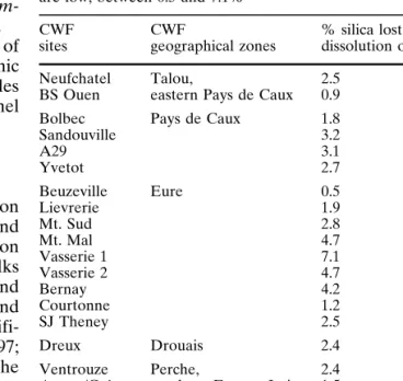
The thickness of chalk removed by weathering, calculated for the 22 CWF sites, varies between 10 and 205 m (Fig. 4). Viewed by study area it is noted that: 1. In the Talou and eastern Pays de Caux, the thickness
of dissolved chalk is small, with 10–11 m leaving a 3 m thick CWF.
2. In the remainder of the Pays de Caux, dissolution of 40–43 m of chalk resulted in 10 m of CWF.
3. In the Eure, the thickness of removed chalk varies with location, from 91 to 100 m for 20 m of CWF in the central area and from 29 to 84 m leaving 7 to 15 m in the western part.
4. In the Perche, a thickness of dissolved chalk of 31 m gave rise to 6 m of CWF.
5. In the Drouais, 23 m of chalk left behind a 5 m layer of CWF.
6. In the northern Eure et Loir, where thickness is greatest, dissolved chalk was 196–205 m thick resulting in 40 m of CWF.
The ratios of dissolved chalk thickness to CWF thickness for the aforementioned figures vary between 3.3 and 5.6 (Fig. 4).
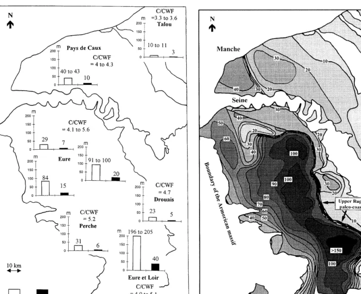
The application of these ratios, using the SynerGIS Geographical Information System (according to the method presented above), to the whole of the western Paris Basin results in the map shown in Fig. 5. This map shows that the thinnest amount of dissolved chalk (10 m) occurs in the Talou and eastern Pays de Caux, and the thickest (100–200 m) in the central Eure and northern Eure et Loir, showing an axis trending NNW–SSE. Along this axis, the thickness of dissolved chalk diminishes abruptly to the ENE, but more progressively to the SW towards the Armorican boundary.
472
Fig. 4 Thickness of chalk removed by dissolution during the
weathering, calculated from the 22 clay with flints sites (located in Fig. 1). CWF clay with flints; C/CWF ratio of thickness of chalk dissolved to thickness of clay with flints. The calculation of dissolved chalk thickness was made for the 22 CWF sites. Here, results are presented according to the five CWF geographical zones. The thickness of dissolved chalk calculated from the CWF present today varies between 10 and 205 m and the ratios of dissolved chalk thickness to the CWF thickness vary between 3.3 and 5.6. The thickness of dissolved chalk shows regional varia-tions which are connected to observed variavaria-tions in the thickness of the CWF
Fig. 5 Thickness of chalk lost by dissolution during Cenozoic
weathering in the western Paris Basin. Dissolved chalk thickness contours are given in metres. This map shows that the largest thickness of dissolved chalk ( 1 100 m) occurs in the central Eure and northern Eure et Loir, showing an axis trending NNW–SSE. The abrupt reduction in thickness of dissolved chalk on the ENE of the central NNW–SSE axis corresponds to an Upper Rupelian palaeo-coastline
Weathering rate
The calculated weathering rate is:
1. For the CWF of Talou and eastern Pays de Caux, 10 m/Ma
2. For the CWF of Pays de Caux, 14.8 m/Ma 3. For the CWF of Drouais, 5.5 m/Ma 4. For the CWF of the Eure, 2.1 m/Ma
5. For the CWF of Perche and northern Eure et Loir, 2.1 m/Ma
Discussion
The preservation of the stratigraphic succession of the chalk in the CWF profiles indicates that weathering took place in situ without significant disturbance (Laignel 1993, 1997; Quesnel et al. 1996; Quesnel 1997).
The occurrence of Maastrichtian microfauna in the flints of the CWF, noted by Quesnel et al. (1996) for the north western part of the Paris Basin, shows that Maastrichtian chalk once existed in the Paris Basin, even if it is now absent. This observation is confirmed here across the whole Basin, apart from its most
west-erly part (Fig. 2). This absence need not necessarily be interpreted as a break in Maastrichtian sedimentation at this location. In fact, Maastrichtian foraminiferae occurring most commonly in the south west point to the existence of an exposed circalittoral environment (Bourdillon and Quesnel 1996). This suggests that the sea covered the whole of the western Paris Basin until Maastrichtian times and this to a considerable depth. The absence of the Maastrichtian here could therefore be linked to mechanical erosion which may have been responsible for the removal of the upper parts of CWF profiles in the most western areas. However, this hypo-thesis is not very likely, because the CWF profiles, notwithstanding the fact that they are reduced, show a vertical differentiation identical to thicker, eastern profiles. Furthermore, no erosional feature has ever been found at the top of the CWF. The most likely hypothesis is that the Maastrichtian deposits of the extreme western part of the Paris Basin occurred, as elsewhere in northwest Europe, as tufa (sandy chalk without flints), with only poor potential for the preser-vation of microfauna (Bignot et al., in press).
The original thickness of the dissolved chalk varies between 10 and 205 m, according to distinct regions. There is a relationship between this variation in thick-ness and the observed thickthick-ness of the CWF in each of the different geographical areas studied in the western Paris Basin. The ratios of dissolved chalk thickness to CWF thickness also show regional variations (Fig. 4). These differences are, however, quite small and easily accounted for. The ratios appear directly related to the quantity of flint present in the CWF and the chalks. In turn, the amount of flint varies gradually and regionally for the CWF (with ca. 45% flint content to the north of the river Seine and 50% to the south) and stratigraphi-cally for the chalks (with 0–5% flint for the Turonian, 10–14% for the Coniacian and ca. 15% for the Santonian and the Campanian).
For the Talou, the eastern Pays de Caux and Drouais regions, where dissolved chalk thickness is smallest, Quesnel (1997) demonstrated the occurrence of remnant palaeo-CWF on Upper Thanetian marine erosion platforms in the case of the Talou and eastern Pays de Caux, and on Upper Rupelian marine erosion platforms in the Drouais. These palaeo-CWF have been eroded and currently are only preserved in the form of cobble pavements. This suggests that the thick-ness of dissolved chalk in the two areas has been under-estimated. According to the stratigraphic succession of the chalk observed in the CWF in these areas and the calculation methodology of dissolved chalk thickness, Quesnel (1997) calculated that these palaeo-CWF would not have exceeded 2–3 m in thickness, equating to a thickness of approximately 8–12 m of dissolved chalk. This should be added to thickness calculated for the CWF present today in these areas. The previously small amount of dissolved chalk calculated for the Talou and eastern Pays de Caux is thus increased from 10 to approximately 20 m. The small thickness of chalk
dissolved in this northeastern area is accounted for by the presence of an impermeable covering of Tertiary sediments which, from the Upper Thanetian until its removal in the Pliocene, protected the chalks from weathering processes (Quesnel 1997).
The abrupt reduction in thickness of dissolved chalk on the ENE of the central NNW–SSE axis (where dissolved chalk thickness is greatest), observed in Fig. 5, therefore corresponds to an Upper Rupelian palaeo-coastline. Furthermore, the lack of dissolved chalk observed in the SE in Fig. 5 is explained by the presence of a thick covering of Tertiary sediments which has protected the chalks from weathering. Finally, the progressive reduction in dissolved chalk thickness, then its disappearance in the SW, may be interpreted as evidence of sedimentary bevelling of the chalk on the boundary of the Armorican massif.
The comparison of weathering rate calculated for the CWF (2.1–14.8 m/Ma) with those calculated for the saprolites of the Congo and the Amazon (8–10 m/Ma) (Probst 1992) and those calculated for the calcareous sediments of Australia (6–13 m/Ma) (Smith et al. 1995) shows than these values are similar.
Conclusion
Study of the age of the parent chalks from which the CWF derive and the determination of the thickness of chalk lost through dissolution has provided important information regarding the Upper Cretaceous chalk deposits of the western Paris Basin and their evolution during the Cenozoic.
Micropalaeontological study of flint contained in the CWF shows that practically all of the Upper Creta-ceous series up to the Maastrichtian were deposited in the western Paris Basin. During the Cenozoic, the chalks underwent weathering that resulted in the formation of CWF deposits. The preservation of the stratigraphic succession of the chalk in the CWF profiles, and the consistent presence of Upper Campanian or Maastrichtian at the top of the sections, respectively, indicate that the weathering took place in situ and that the profiles experienced virtually no mechanical erosion. Weathering led to the dissolution of 20–200 m of chalk, with regional variations. These regional variations are closely linked to observed geographic variations in CWF thickness. The present geometry of the CWF thus appears to provide evidence of synsedimentary thickness variations of the original chalks. The calculated weathering rate varies between 2.1 and 14.5 m/Ma.
This study is also valuable by virtue of the method used to quantify the amount of dissolved chalk. This is a new approach that can be applied not only to other CWF elsewhere in the Paris, Aquitaine and London basins, but also to other calcareous deposits resulting from weathering processes. It would appears that
474
previous estimations on weathering rates and volumes of chalk should be reconsidered for NW Europe: the thickness of dissolved chalk should be calculated from an “isoflint” weathering balance corrected in according to the dissolution of flints during the weathering, and the limit of expansion of the Maastrichtian sea should be reconsidered from the study of siliceous powder contained in the flints of CWF.
References
Bauer J (1964) Etude sédimentologique comparée de quelques échantillons de craie et d’argile à silex à l’Ouest de Paris. Soc Géol France, Paris, pp 75–79
Bignot G, Quesnel F, Bourdillon C (in press) Le Crétacé terminal et le Paléocène basal de l’Europe nord-occidentale. Géol France
Bonte A (1955) Les formations superficielles à silex du Nord de la France. C R Acad Sci Paris 241 : 1211–1213
Bourdillon C (1996) Nouvelle biozonation des foraminifères dans la craie du Bassin Parisien, In Colloque La craie, objet géolog-ique, réservoir, matériau et paysage. Réunion SGF-SGN-GFC, Arras, p 21
Bourdillon C, Quesnel F (1996) Le Maastrichtien de Normandie (France): Microfaune, paléomilieux, paléogéographie, In Colloque La craie, objet géologique, réservoir, matériau et paysage. Réunion SGF-SGN-GFC, Arras, p 22
Brajnikov B (1938) Recherches sur les formations dites “argiles à silex” dans le Bassin Parisien. Rev Geogr Phys Géol Dyn Paris 10 : 1–129
Callot G, Pedro G (1977a) Relations entre la présence de couver-tures d’argile à silex et la nature du substratum carbonaté. Rôle et origine des silex. C R Acad Sci Paris 285 : 1295–1297 Callot G, Pedro G (1977b) Théorie sur la formation des argiles à
silex. C R Acad Sci Paris 285 : 1415–1418
Catt JA (1986) The nature, origin and geomorphological signifi-cance of CWF. In Sieveking G, Hart MB (eds) The scientific study of flint and chert. Cambridge University Press, Cambridge, pp 151–159
Dewolf Y (1976) A propos des argiles à silex: Essai de typologie. Rev Géomorph Dyn 25 : 113–138
Dewolf Y (1977) Désilicification et silicifications secondaires de certaines argiles à silex des marges occidentales du Bassin de Paris. C R Acad Sci Paris 284 : 725–728
Dewolf Y (1982) Le contact Ile de France – Basse Normandie. Etude géodynamique. Mém Doc Géogr, CNRS, Paris Ehrmann WU (1987) Quantification of nodular flints, upper
Cretaceous, Laegerdof, NW Germany. In colloque Le silex de sa genèse à l’outil. CNRS 17 : 69–75
Jukes-Browne AJ (1906) The clay-with-flints: its origin and distri-bution. Q J Geol Soc Lond 62 : 132–164
Klein C (1970) La surface de l’argile à silex. Rev Géogr Phys Géol Dyn 2 : 180–220
Laignel B (1993) Les matériaux résiduels à silex de la marge occi-dentale du Bassin de Paris. Caractérisation, bilan des transfor-mations minérales au cours de leur genèse et utilisation poten-tielle comme granulat. Mém D.E.A, Orléans
Laignel B (1997) Les altérites à silex de l’ouest du Bassin de Paris. Caractérisation lithologique, genèse et utilisation poten-tielle comme granulats. Thesis, Rouen, BRGM, Orléans, 224 pp
Laignel B, Quesnel F, Macaire JJ, Meyer R (1998a) Relations quantitatives entre les craies à silex et les formations rési-duelles à silex de l’ouest du Bassin de Paris. Geodyn Acta 11 : 171–181
Laignel B, Quesnel F, Lecoustumer MN, Meyer R (1998b) Varia-bilité du cortège argileux des formations résiduelles à silex de l’ouest du Bassin de Paris. C R Acad Sci Paris 326 : 467–472 Lautridou JP, Ozouf JC (1987a) Définition de normes d’analyses
physiques de roches. Acquisitions nouvelles sur la porosité et sur la perméabilité des roches au cours des dix dernières années. Mém CNRS, Caen
Lautridou JP, Ozouf JC (1987b) Définition de normes d’analyses physiques de roches. Etude critique des normes employées, proposition de nouvelles normes. Mém CNRS, Caen Lelong F (1969) Nature et genèse des produits d’altération de
roches cristallines sous climat tropical humide (Guyane fran-çaise). Mém ENSG 14 : 1–188
Lelong F, Souchier B (1972) Comparaison des bilans d’altération sur roches granitiques en zone tempérée et en zone équato-riale. C R Acad Sci Paris 274 : 1896–1899
Megnien C, Megnien F et al. (1980) Synthèse géologique du Bassin de Paris. Mém BRGM, Orléans, 3 vol, nos. 101, 102, 103
Murata KJ, Norman MB (1976) An index of crystallinity for quartz. Am J Sci 276 : 1120–1130
Probst A (1992) Géochimie et hydrologie de l’érosion continen-tale. Mécanisme, bilan global actuel et fluctuations au cours des 500 derniers millions d’années. Sci Géol Mem 94 : 1–167 Quesnel F (1997) Cartographie numérique en géologie de
surface. Application aux altérites à silex de l’ouest du Bassin de Paris. Thesis, Rouen, BRGM, Orléans, 204 p
Quesnel F, Bourdillon C, Laignel B (1996) Maastrichtien supér-ieur au Nord-Ouest du Bassin de Paris (France). Témoins résiduels en Seine-Maritime. C R Acad Sci Paris 322 : 1071–1077
Smith DI, Greenway MA, Moses C, Spate AP (1995) Limestone weathering in eastern Australia. Part 1. Erosion rates. Earth Surf Processes Landforms 20 : 451–463
Vilas Boas G (1975) L’altération des accidents siliceux, silex et chailles dans les formations paléogènes du Bassin de Paris. Thèse 3e cycle, Strasbourg, 110 p