HAL Id: hal-00297062
https://hal.archives-ouvertes.fr/hal-00297062
Submitted on 2 Jan 2008
HAL is a multi-disciplinary open access
archive for the deposit and dissemination of
sci-entific research documents, whether they are
pub-lished or not. The documents may come from
teaching and research institutions in France or
abroad, or from public or private research centers.
L’archive ouverte pluridisciplinaire HAL, est
destinée au dépôt et à la diffusion de documents
scientifiques de niveau recherche, publiés ou non,
émanant des établissements d’enseignement et de
recherche français ou étrangers, des laboratoires
publics ou privés.
Characterization of a rock avalanche deposit for risk
assessment in the town of Celano (Fucino Basin, Central
Italy)
A. Rinaldini, A. Marino, M. Ciucci
To cite this version:
A. Rinaldini, A. Marino, M. Ciucci. Characterization of a rock avalanche deposit for risk assessment
in the town of Celano (Fucino Basin, Central Italy). Advances in Geosciences, European Geosciences
Union, 2008, 14, pp.155-158. �hal-00297062�
www.adv-geosci.net/14/155/2008/ © Author(s) 2008. This work is licensed under a Creative Commons License.
Geosciences
Characterization of a rock avalanche deposit for risk assessment in
the town of Celano (Fucino Basin, Central Italy)
A. Rinaldini, A. Marino, and M. Ciucci
Institute for Health and Safety at Work, Rome, Italy
Received: 15 July 2007 – Revised: 23 September 2007 – Accepted: 24 September 2007 – Published: 2 January 2008
Abstract. This paper describes multidisciplinary
investiga-tions carried out in the urban centre of Celano, a small town located at the northern edge of the Fucino Basin (Central Italy). The town lies upon a wide debris body that was rec-ognized in this study as a rock avalanche deposit estimated to date to the Holocene. Geomorphologic studies and geo-physical investigations led to a detailed characterization of the landslide deposit and the surrounding units. The infor-mation obtained was used to assess the vulnerability of the Celano municipal area, by evaluating the stability of the land-slide body and the behaviour of its lithologies under seismic loads.
1 Introduction
This paper presents multidisciplinary data collected to assess the mass movement hazard conditions in the urban centre of Celano, a small town located at the northern edge of the Fu-cino Basin. The town lies upon a wide landslide body that is characterized by a sliding surface separating two different lithologies: the slope materials involved in the gravitational movement and the alluvial sediments at the bottom. This fea-ture, and the mass movement kinematics, characterized by a steep run-out path with a wide spreading of the toe, indicate that the landslide is a rock avalanche. Local contributing fac-tors were steep relief and the neotectonic activity of faults located near the landslide scarp.
2 Geological framework
The Fucino basin is delimited by Meso-Cenozoic limestone ridges that have been shortened, folded and thrusted toward NE by a complex sequence of compressional phases since
Correspondence to: A. Rinaldini
(al.rinaldini@libero.it)
the late Miocene. In the late Pliocene, post-orogenic exten-sion created a basin with a half-graben structure, resulting from several depositional phases (Late Pliocene-Holocene), in a thick fluvio-lacustrine succession with thickness of about 1000 m (Cavinato et al., 2002).
The town of Celano is located in the northern edge of the basin and lies upon a hill formed by heterogeneous calcare-ous blocks derived downslope from the structure of Mt. Serra (Fig. 1) . In the lowest areas around Celano, out crops of alternating fine grained materials are found associated with depositional cycles that took place in a fluvio-lacustrine en-vironment during the Holocene (Cavinato et al., 2002).
3 Landslide morphology and morphometry
The failed Celano rock mass slid from the southern slope of Mt. Serra (Fig. 2) and originated in a markedly concave failure surface within the limestones. The body consists of a typical rock avalanche deposit, i.e. a chaotic, though well delimited and internally continuous heap of fragments and blocks up to several cubic meters in size (Fig. 3).
The rock avalanche outline is characterized by a hum-mocky surface with the lower parts buried with fluvio-lacustrine materials separated by well developed calcareous transverse ridges. The rock avalance length is 1070 m and it has an estimated total volume of nearly 40 million m3. The landslide deposit is composed of a chaotic placement of blocks with sizes varying from a few decimeters to sev-eral cubic meters, and composed of intramicritic and oolitic limestones, embedded in calcareous breccias and joined by carbonatic cement.
156 A. Rinaldini et al.: Characterization of a rock avalanche deposit for risk assessment
Table 1. Elastic modula from cross-hole prospectings. δ=terrenes bulk density; V s=S-waves velocity; Vp=P-waves velocity;
Gmax=maximum shear modulus; EY=Young’s modulus; ν=Poisson ratio.
Depth (m) δ(kg/m3) V s(m/s) V p(m/s) Gmax(MPa) EY (MPa) ν
8–12 1800 472 1600 400 1163 0.45 16–18 2300 714 2000 1173 3349 0.43 22–24 2300 1042 2400 2496 6908 0.38 26–28 2300 943 1900 2047 5471 0.34 30–32 2300 980 2300 2211 6141 0.39 34–36 2300 1042 2200 2496 6766 0.36 38–40 1900 490 2000 457 1340 0.47
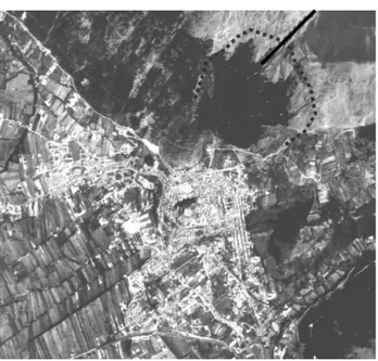
Fig. 1. Aerial photograph of Celano town: are indicated the
land-slide failure surface (dashed line) and the S. Vittorino fault (solid line).
4 Geophysical investigations
Vertical Electrical Soundings (VES) and Electrical Resistiv-ity Tomography (ERT) surveys were used in combination to calibrate multielectrodic profiles and to evaluate the es-timates of the landslide deposit depths. Additionally, the VES-ERT combination was used in cases where ERT results differed from the terrain.
4.1 Vertical electrical soundings
Investigations consisted of 12 VES, two of which were used for the calcareous material calibration. A Schlumberger re-sistivity configuration with AB/2 up to 250 m was chosen, reaching investigation depth intervals ranging from 60 to 80 m. The VES model was developed using the theoretical
Figure 2: Northwestern view, town of Celano, with the slope of Mt. Serra on the righ
Fig. 2. Northwestern view, town of Celano, with the slope of Mt. Serra on the right.
curves of the apparent resistivity, on which was subsequently applied the iterative resolution method of the steepest de-scent (Koefoed, 1979). VES data indicate a presence of strata with resistivity values characteristic of calcareous lithologies within conductive zones characteristic of silty-clayey mate-rials.
4.2 Electrical resistivity tomography
The Wenner, Schlumberger and radial dipole-dipole arrays were adopted for each of the four multi-electrodic surveys carried out in Celano. Measured values were then analysed using Res2Dinv software (Loke, 1998) which provides the most suitable parameters for the reconstruction of the terrain physical model. The results of each configuration were then analysed and compared with the corresponding VES models. ERT terrane models are characterized by sub-parallel strata with some lateral variation along the section and with resis-tivity values generally increasing with depth.
Fig. 3. Geologic section showing the path and the main geomorphic features of the Celano rock avalanche; the location of boreholes drilled
at Borgo Monterone, Via la Torre and New A.s.l is also indicated.
Legend:
SA-1 SA-2: “twin” soundings S: source
G: geophone
Mi: acquisitions every 2 m.
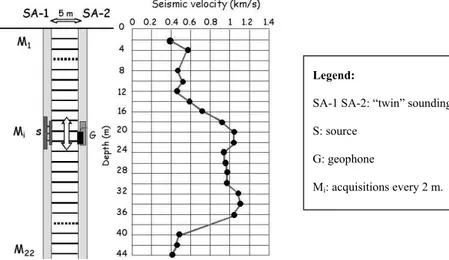
Fig. 4. Acquisition scheme from Cross-Hole waves S in New Asl site (see Fig. 3 for location).
4.3 In situ seismic surveys
SA-1 and SA-2 “twin” soundings, located 5 m apart from each other were drilled near the geoelectric survey locations. Cross-hole (C-H) investigations were carried out in these soundings. The holes hosting geophones were filled with water to enhance continuity of wave transmission between geophones and the ground.
4.3.1 Cross-hole P-waves
Values were elaborated considering linear ray paths of P-waves and the investigated section was divided into 2×5 m cells characterized by a constant velocity. An inversion al-gorithm with a constant damping factor of 1.6 was used for data interpretation.
4.3.2 Cross-hole S-waves
S-wave measurements were acquired every 2 m using a tri-directional geophone, with a maximum investigation depth of 44 m (Fig. 4). Elastic parameters of the investigated mate-rials were calculated from compression and shear wave val-ues and with consideration of the soil bulk density. P and S cross-hole wave investigation indicated sharp variations of the materials throughout the section that was studied, as in-dicated in Table 1.
5 Conclusions
The comparison and integration of data from geoelectrical surveys and cross-hole geophysics provided a detailed frame-work of the rock avalanche deposit arrangement and impor-tant information related to the geomechanical characteriza-tion of the rocks in the deposit.
158 A. Rinaldini et al.: Characterization of a rock avalanche deposit for risk assessment Models developed from the ERT data highlighted some
lateral resistivity variation of the investigated mediums only in the shallower part of the landslide body, with sub-horizontal electric strata and resistivity values generally in-creasing with depth. The ground models obtained from geo-electrical prospecting fit with the stratigraphy identified by the drill cores.
Cross-hole geophysics provided a characterization of the lithologic succession present in Celano, with respect to the physical, mechanical and dynamic properties of the materi-als. Geophysical variation was shown between the investi-gated layers, not only between the landslide’s body and the embedding terrigenous materials, but also in the calcareous debris itself. This evaluation of the dynamic behaviour of lithology contributes to a quantitative evaluation of the vul-nerability of Celano.
Edited by: P. Fabian
Reviewed by: B. Malamud and M. Larsen
References
Cavinato, G. P., Carusi, C., Dall’Asta, M., Miccadei, E., and Piacen-tini, T.: Sedimentary and tectonic evolution of Plio-Pleistocene alluvial and lacustrine deposits of Fucino Basin (Central Italy), Sed. Geol., 148, 29–59, 2002.
Loke, M. H.: RES2DINV, Rapid 2D resistivity and IP inversion using the least-squares method, User Manual, Austin Tex, Ad-vanced Geoscience Inc., 1998.
Koefoed, O.: Resistivity soundings measurements, Amsterdam, El-sevier, 1979.

