OATAO is an open access repository that collects the work of Toulouse
researchers and makes it freely available over the web where possible
Any correspondence concerning this service should be sent
to the repository administrator:
[email protected]
This is an author’s version published in:
https://oatao.univ-toulouse.fr/22272
To cite this version:
Rautu, Dorin and Dhaou, Riadh and Chaput, Emmanuel
Crowd-based positioning of UAVs as Access Points. (2018) In: 15th IEEE
Consumer Communications and Networking Conference (CCNC
2018), 12 January 2018 - 15 January 2018 (Las-Vegas, United
States).
Open Archive Toulouse Archive Ouverte
Officiel URL :
Abstract—Unmanned Aerial Vehicles (UAVs) can be a cost
saving and easy to deploy solution to implement a temporary network infrastructure. They can act as access points in scenarios such as emergency situations, special events, or specific area monitoring.
Two main deployment families can be found in the literature. The first one, the location-based family, is based on the funda-mental assumption that the network user positions are known. We do believe that this could not suit the most general scenarios. On the other hand, the location-independent family can not be as efficient as the first one. The main idea in this paper is to introduce a new crowd-based family, based on a probabilistic knowledge of user positions.
We then propose a self-deployment method built on a Coulomb’s law analogy where users and UAVs act as electrical charges. Short range interactions are implemented through network sensing, while long range ones use a crowd-based approach. Some numerical results are depicted, showing the performance of this self-deploying mechanism as well as a comparison with a well-known clustering algorithm.
Index Terms—UAV, drone, deployment, potential field
I. INTRODUCTION
In some scenarios where a network infrastructure needs to be deployed within short delays, Unmanned Aerial Vehicles (UAVs) can be an efficient solution.
Indeed, installing cables, antennas or satellite access require heavy investments. Besides, as drones are moving objects, they can reach areas inaccessible to humans, making them a practical solution for impractical zones. Of course, satellites can also fulfill this task, with a greater range of action, but cost, maintenance and deployment time are still problematic. In this paper, we consider the deployment of a wireless mesh network of drones in a remote area where the quality of the network is too poor to establish communications. Thus, in this network of UAVs, the objective would be to convey voice, but also video or data from users in difficult to access areas. For instance in the context of a natural disaster in the mountains where the classical telecommunication infrastruc-ture is no longer operable. Our aim is to be able to offer communication services to first responders, to facilitate the coordination and intervention. We would then have a network of drones that can be interconnected to the Internet via a satellite gateway.
The goal of this paper is to study a novel self-deploying mechanism for this drone network, capable of covering many users without knowing the exact initial user positions. The idea is to use a potential field like approach for the deployment. There are plenty of research done on mobile
cells, access point or sensor deployment, but, as far as we know, limited research was done on drone deployment as a temporary access point without a priori information on user positions.
The paper is organized as follows. Section II presents a short state of the art of existing deployment methods. Section III introduces the scenario, offers a detailed picture of our method and the model implementation, Section IV presents the general results as well as a comparison between our model and a clustering algorithm, and in the end, some research tracks for future work and a conclusion are given.
II. RELATED WORKS
To better understand the deployment solutions already present in the literature, we classified them into two groups: location-based methods, i.e. requiring initial positions of nodes or users and location-independent algorithms.
A. Location-based deployment methods
In [1] the authors propose a two-step approach, grid search, and enhancement prediction, to determine the best antenna positions for femtocell deployment. User locations and traffic demand have to be known in advance by the command center to maximize the gain, applying a centralized approach.
The authors of [2] are proposing another optimization approach called Mobile Small Cell Deployment (MSCD) that tries to maximize the total in-service time of mobile clients. The mechanism is a reduction for the facility location problem. After computing the best positions, the antennae will be placed randomly at some of these positions. Similar work is also presented in [3] where the authors minimize macrocell resource usage by computing the best femtocell positions.
Wang et al. presented in [4] an algorithm called Coverage Configuration Protocol (CCP) for sensor networks. It can determine the nodes’ placement to maintain a configurable degree of coverage by intersecting the sensing circles. In [5] another approach for sensor networks called Optimal Geographic Density Control (OGDC) tries to minimize the overlap between sensing disks to cover a given area.
All these approaches are centralized and static. To de-termine the optimal deployment, location calculations must be made in advance. If user hot-spots tend to change, the antennae positions have to be recomputed.
Besides, several placement strategies can adapt the de-ployment to mobile clients. These approaches were primarily based on drones as nomadic platforms. In [6], [7], [8], [9]
Crowd-based
positioning of UAVs as Access Points
Dorin
RAUTU, Riadh DHAOU and Emmanuel CHAPUT
Universite´ de Toulouse; INP; F-31071 Toulouse, France; IRIT; F-31062 Toulouse, France
different optimal heuristics are presented for access point placement. The authors of [6] search to place drones as repeaters, relaying access points to users. By solving the optimization problem, they maximize the end to end data rate. They examine the optimal position between access points and users. In [7], the goal is to provide better coverage to public services; the access points are embedded on drones. By brute force search, the UAVs are placed in areas where the signal to noise ratio of base stations is weak. Knowing the user positions, they adjust the UAV placement to maximize the network throughput. The same technique is used in [8] where the authors are maximizing the signal to noise ratio consider-ing co-channel interference in a UAV mobile access network. In [9], optimization heuristics are used to minimize the overall transmit power in a mobile network covering ground users. Even though the methods can adapt to user movement, the computation still has to be done in a centralized manner.
A different plan of attack for deploying nodes to cover users are the location-based clustering techniques. In [10], three deployment schemes are proposed based on Voronoi polygons. These solutions have the advantage to be distributed, each node calculates and moves to the most favorable position. In [11], Intelligent Deployment and Clustering Algorithm (IDCA) is proposed using local clustering to place sensors uniformly by moving in an energy efficient manner.
Two similar optimization approaches are presented in [12], [13] each of them based on k-means. The former shows an algorithm calculating UAV locations based on clustering. They minimize the overall users’ distance to the cluster centroid. The latter computes k clusters by minimizing the squared distance between clients and drones, placing them in the center of clusters. Both have the benefit of adapting to user movement, but they use a centralized approach.
To summarize, there are many location-based algorithms developed either for mobile cells placement, wireless sensor networks or mobile access points using UAVs. They are either optimization based or clustering approaches, the main criteria for searching the best placement is either user oriented (in-service time, throughput), or network oriented (signal to noise ratio, interference, energy efficiency).
We do not consider using any of this solutions mainly because, in our system, the user positions are not known in advance and we consider that it is not feasible in real life. In the second part, some location-independent approaches are presented.
B. Location-independent methods
Regarding the solutions that do not use location information as input, [14] presents a random mobile small cell placement approach. The idea is to place picocells in a given area, ran-domly. The authors compare this method to a grid placement showing that the performance loss is insignificant compared to planning costs for grid placement.
The authors of [15] propose to cover a given area, modeled as a circle by the use of the circle packing theory. The purpose is to place several drone access points as so each coverage
radius helps to fill the area. By adapting the transmission power, they make sure that the circles don’t overlap, so they do not create interference. A similar method was also presented in [16]. Here, the authors optimize the number of wireless access points to fill the region, obtaining a total coverage. They are also using them to locate users. They control the localization accuracy by varying the AP’s radius.
This kind of solutions cannot be put in place in our scenario as the number of UAV has to be significant to cover the entire area, wasting resources, in case users are concentrated in a single place, for example.
In wireless sensor network, another method is used besides those presented above. In [17], [18] another deployment scheme for sensors is presented, using the physical principle of potential fields. Like charges repel, and opposite charges attract. An optimization approach is used in [17]. The authors are using the potential field approach to maximize the distance between sensors and to minimize the repulsion interactions. A similar technique is used in [18], where the authors place sensors acting as electric charges influenced by other sensors or obstacles. They manage to cover the given area with minimal movement; the sensors move only when a force is exerted on them.
A summarized version of the related works is presented in figure 1.
Our objective is to build a versatile solution, and we believe that it should be crowd-based, distributed and dynamic. For these reasons, our method is mainly based on potential field law. In the articles cited above, this solution has been used to minimize sensor movement and overlap. In our case, we aim to use this technique to search and find users on the ground as well as covering them in the most efficient way. The energy saved by optimal moving is an interesting side effect that will be investigated later.
In order to evaluate the consequence of not knowing user positions, we will compare our solution with a location-based one. We have chosen to use k-means based one as our solution could be thought as a distributed flavor of such an algorithm. We then hope to minimize the sources of bias.
III. PROBLEM MODELING
A. Scenario
Our primary objective is to use a fleet of UAVs as a backbone for network connectivity. Users are scattered in a given area, and they can move (depending on the scenario). For this reason, we believe that location-based methods do not suit such a scenario. Because of their movements, UAVs may not be able to maintain a permanent connectivity and, as a consequence, any centralized or even cooperative method seems impossible. Accordingly, we will propose a distributed method.
As an example, one could imagine an emergency situation (earthquakes, fire, nuclear disasters, etc.). The UAVs can be used to help the rescue teams providing communication means as well as for observation (cameras on board). Another scenario is the deployment of a cultural or sporting event.
Fig. 1. Classification of placement methods
There again, the UAVs will help the organizers by providing communications, observation means or data collection (from sensors on the ground or the participants).
B. Crowd-based methods
In the most general scenario, user positions are unknown. For this reason, we do not believe that location-based methods could wildly be used. On the other hand, most scenarios exhibit a non-uniform distribution.
Location-based methods are not aware of this behavior, and the performance may suffer from it. To circumvent this drawback, we introduce a new class: crowd-based methods. The basic idea is that, even though the actual position of each user cannot be known with precision, we have some information that can help us to determine areas where users can be found. Such gathering areas can be imagined around specific spots depending on the scenario. We can also imagine crowd movements such as supporters during a sporting event, or a herd in wildlife observation. In this paper, we will focus on scenarios where users are gathering around some spots called Point of Interest.
C. Our approach
1) User position: To represent the crowd phenomenon, we
introduce the notion of Point of Interest (POI). Users are supposed to be close to POIs. A Point of Interest could be any special spot, depending on the scenario (a command center in emergency situations, a refreshment point in a sporting event, etc.). The position of a particular user is not known, but the well-known position of the POI give some statistical information about user positions. An important property of a POI is its attractiveness, which measures how close users are from it. We will give a formal definition later on.
TABLE I SCENARIO PARAMETERS characteristics value # users 300 # UAVs 5 - 30 # POIs 5 area size 0.8km2 tests/value 50
coverage continuous coverage
2) Introduction: To fulfill our objective, we need the UAVs
to move toward the users. Of course, we want a cost-effective solution, so each UAV has to cover as many users as possible. We will use the Points of Interest to estimate users position; our solution is then a crowd-based one. Furthermore, we want the UAVs to be able to act autonomously. These constraints lead us to use a model based on electrically charged particles interactions.
3) Model description: We want to place UAVs as access
points above a large number of users with random positions in a defined area. UAVs are thus supposed to get as close as possible to a maximum number of users. For this purpose, we have chosen to represent their interactions with the help of a model inspired by Coulomb’s law. In this model, a user is described as a positive electric charge and a UAV as a negative electric charge. UAVs are then attracted by users.
There are, however, lots of fundamental differences with the well-known law of physics. These variations come from the objectives of our model:
• Users should not be repelled by one another, so there is no interaction between them in our model.
• We want the UAVs to move towards the users, but the users are free to move without any constraints, therefore they are not attracted by the drones.
• In a real world implementation, UAVs can not be aware of out of range users, so in our model interactions take place in the sensing range, namedd.
• To implement multiple channels ”particles” come in different colors. Those with different colors can not interact, whatever their charge is.
• Particles can spontaneously change their color. With this option, we plan to implement some form of load balancing.
Figure 2 illustrates this model. Three UAVs (named Ui) cover seven users (A to H). Each UAV is placed at the
centroid of its users, as a consequence of the sum of the forces, they exert on it.U2has no interaction with other UAVs, while
U2andU3repel.D could change its color from orange to blue
(associating withU1).
Please note that the defined sensing range d should be
chosen in accordance with the physical network used. If a user is detected in this area, the UAV will be then attracted to it. However, by setting d = ∞ our solution becomes a
Fig. 2. Illustration of our model
4) Initial position: We imagine that the drones leave from
the management center, placed arbitrarily at (0, 0). They will activate the sensing mechanism to search the users. Their goal is to fly towards the POIs, searching for users. As soon as a UAV finds someone, it will stop over to cover the users. The major risk is that they will get attracted by isolated users on their way to the Points of Interest.
Of course, this problem increases when the attractiveness of the POI decreases. The more the users are gathered around the POIs, the less isolated clients could attract a UAV.
For these reasons, we imagine varying the position where the drone activates the sensing mechanism. This will help us to analyze if the initial position of the drone impacts the results. We can also imagine activating the UAV either at a random position or when it arrives over a certain POI. We call these two versions Cd,R, when the drones are activated at a random position andCd,P when they are activated at the POI.d is the sensing range, previously described.
5) Location based version: We plan to study the
dif-ference between our probabilistic location-based model and a pure location-based model. We modified our algorithm, for comparison reasons, by increasing the sensing range to infinity. Hence, we introduce here C∞ when our model has every user positions. We then compare our method with a clustering mechanism like k-means. Since the algorithm imposes a global knowledge of users locations, we cannot limit its sensing range. Similarly, we call it k∞. In either case, when each algorithm finishes placing the drones, we will measure the coverage rate by taking into account only the users that are in the sensing range of UAVs/clusters.
In the next part, we will present how this model is imple-mented in our simulator.
D. Model implementation
The purpose of this section is to expand on the implementa-tion choices made for simulaimplementa-tion purpose. Our simulator was created in Java for easy access to a graphical interface.
The basic idea is to simulate the attraction and repulsion forces between users and drones as well as the coverage of UAVs over the users. Our model can be adapted to whichever wireless physical technology as the ”electrical field” emitted by charges is based either on the signal power or the media access control messages like Wi-Fi beacons, for instance.
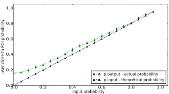
Fig. 3. Difference between theoretical and actualp
The fundamental principle of the developed model is that the UAVs will be attracted by users, having opposite charges, and repelled by other UAVs, like charges.
Each user has a weight, the quantity of charge. This feature can be used to prioritize users, by type of demanded service or importance, firefighters, organizers, etc. Earlier we introduced the sensing range d. If two drones sensing disks cross each
other, a repulsive force will exert on these UAVs. Both forces are computed by using Coulomb’s law taking into consideration both charges and the distance between the two of them. Each drone movement results from the sum of this two vectors, attractive and repulsive forces. We opted for this solution so if a UAV is connected to lots of users and another drone crosses its sensing range, it will remain static. Only the intruding UAV will repel.
In our implementation, POIs are placed by using a bidi-rectional uniform distribution. Of course, depending on the scenario, more suitable distributions could be used. As for the users, we use the following algorithm. Each user belongs to a specific POI (in this paper, users are equally distributed among POIs). A direction is randomly chosen with a uniform distribution [0, 2π]. The distance from the Point of Interest then follows a normal distribution with standard deviationσ.
We want to focus on the impact of the ”attractiveness” of the POI on the efficiency of the drone positioning algorithm. For this purpose, we define the covering range, equal to the sensing ranged and a probability p that the distance between
a user and its POI is lower thand.
For each simulation, σ is then chosen as a function of p
andd. Figure 3 shows pout as a function ofp, where pout is the probability that a user is at a distance< r from any POI.
We can notice some side effects: 1) the area is finite;
2) a user can be far from its POI but close to another one. These effects lead to a pout value greater than p. This impact is more significant for small values. In this paper, we focus on scenarios where users cluster around the POI. As a consequence, we will not take into consideration the small values of p.
Other meaningful parameters regarding the implementation are presented in Table I. In the next section, we introduce the performance results of our method, as well as the results of the comparison betweenCd,C∞ andk∞.
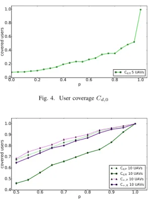
Fig. 4. User coverageCd,0
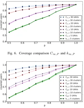
Fig. 5. Coverage comparison between different flavors of our method
IV. SIMULATIONS AND RESULTS
In this section, different test-cases with their results and conclusions about the proposed model will be presented.
A. General results
To start with, we need to check if the drones are indeed trapped by isolated users. We start with 5 Points of Interest and 5 UAVs, departing from the management center at(0, 0). In the results presented in figure 4 we clearly see that our assumptions are confirmed. As the UAVs leave from the same spot flying towards the POIs, they get ”stuck” covering isolated users around (0, 0). As a consequence, the coverage ratio is low, specially for low values ofp.
The need for diversity regarding the UAVs’ start points is thus confirmed. Of course, to limit the deployment costs, all the drones will still leave from (0, 0). We will activate the user detection on each drone when it is already flying. Either when it is in a random position or over the POI.
In the next part, we study the impact of location information on the deployment.
B. Location-based versus location independent
In this section, we analyze the performance of our crowd-based algorithm, Cd, and a location-based version, C∞. We can add this information by increasing the sensing range to
∞. We will then look at both location-based schemes (C∞,P,
C∞,R) and crowd-based schemes (Cd,P,Cd,R).
By analyzing the comparison between Cd,P and Cd,R, in figure 5, we notice that adding some information on potential user positions, by taking into account the POIs, increases
the coverage probability by20%, even though there are 50% chances that the users are located near the point of interest.
We could be tempted to think that having the exact location of each user could be an advantage for covering everyone. Because each drone has a limited coverage range, on the other hand, having this information could be a disadvantage, as a UAV could thus move forward to an unreachable user. Looking at the comparison betweenCd,P andC∞,R orC∞,P we can make the following conclusion. Detecting users only when they are in the drone’s sensing range has the same performances as knowing all the user positions from the beginning. The interest of gathering all the exact positions is minimal compared to the complexity of the gathering method. The measurement of the coverage rate is done by taking into account only the users that are in the coverage range, as explained previously. By not having any information as input to our algorithm, Cd,R, the coverage rate remains low in comparison to the other schemes, hence the importance of POIs.
C. Equivalence between C∞and k∞in a POI based location
scenario
As mentioned earlier, we want to compare the proposed model to other solutions. Our work can also be seen as a method of user clustering. Our solution is then compared to a clustering algorithm like k-means, a classical wildly used location-based solution.
We extensively analyzed the coverage rate of both algo-rithms by varying between 5 and 30 the number of UAVs. With an infinite sensing range for the drones, C∞,P we can be as close as possible to k-means, k∞,P. In figure 6 we can see that our model is performing exactly as k-means in this situation. Both are having the same information, they can cover the users in the same proportion, even if they use different approaches.
We looked then to Cd,P. In figure 7, we present the user coverage comparison betweenCd,P andk∞,P. Globally, our algorithm, without exact knowledge of user positions, but drones activated at POI, performs well in comparison with the clustering mechanism. In this figure, we notice that the clustering method have slightly better results than our algorithm. The initial position information helpsk∞to better place the clusters’ centroids, by taking into account the local information.
As the difference regarding user coverage is fairly small between our model and the clustering algorithm, we con-sider that our contribution is substantial as it demands little resources, no exact location information and no centralized computations. In the next section, we present our conclusions on our work as well as some future works.
V. CONCLUSION AND FUTURE WORKS
In this paper, a novel method of node deployment for a network of UAVs used as access points is presented. By looking at the existing solutions of deployment, two major
Fig. 6. Coverage comparisonC∞,P andk∞,P
Fig. 7. Coverage comparisonCd,P andk∞,P
classes can be distinguished, based and location-independent solutions. With regard to our scenario, we choose to introduce a deployment method that is neither location-based, nor location-independent. For this reason, we propose to describe it as a ”crowd-based” method.
We came up with a solution based on Coulomb’s law. The users are positively charged, and the UAVs are negatively charged, being attracted to users. After presenting the model, some numerical results are described. Also, we compared our model to k-means, a location-based solution. By looking at the comparison, we notice that our solution performs very well, even compared to a location-based algorithm, the benefit being that our proposal demands no exact location information and no centralized computations are needed to deploy the nodes. We are currently working on some experimentations by implementing our model on UAVs, to confirm these results. A real-world implementation will introduce some bias we want to evaluate: there is, of course, no Coulomb’s law available, and we need to use network sensing to drive UAV mobility.
Of course, user mobility is an important point we will study. Being distributed and easy to implement, our solution should be efficient in a mobile scenario. We also plan to implement a covered users’ threshold. Under this limit a UAV will not stop over some covered users, continuing to search better coverage positions.
Besides, we plan to test our model with multiple physical channels by using the color scheme previously described. Our solution is built to behave as a distributed clustering algorithm in such a situation.
Furthermore, as all simulations detailed above are using some users equally distributed between the points of interest,
we can imagine introducing some weight on each POI to proportionally distribute users among them. Another idea is to do an extensive study on the behavior of our method in the case that there is no point of interest defined.
REFERENCES
[1] I. Bahc¸eci, “On femto-cell deployment strategies for randomly dis-tributed hotspots in cellular networks,” in Wireless Communications and
Networking Conference (WCNC), 2014 IEEE. IEEE, 2014, pp. 2330–
2335.
[2] S.-F. Chou, T.-C. Chiu, Y.-J. Yu, and A.-C. Pang, “Mobile small cell deployment for next generation cellular networks,” in Global
Communications Conference (GLOBECOM), 2014 IEEE. IEEE, 2014,
pp. 4852–4857.
[3] M. H. Qutqut, H. Abou-zeid, H. S. Hassanein, A. M. Rashwan, and F. M. Al-Turjman, “Dynamic small cell placement strategies for lte heterogeneous networks,” in Computers and Communication (ISCC),
2014 IEEE Symposium on. IEEE, 2014, pp. 1–6.
[4] X. Wang, G. Xing, Y. Zhang, C. Lu, R. Pless, and C. Gill, “Integrated coverage and connectivity configuration in wireless sensor networks,” in
Proceedings of the 1st international conference on Embedded networked sensor systems. ACM, 2003, pp. 28–39.
[5] H. Zhang and J. C. Hou, “Maintaining sensing coverage and connec-tivity in large sensor networks,” Ad Hoc & Sensor Wireless Networks, vol. 1, no. 1-2, pp. 89–124, 2005.
[6] X. Li, D. Guo, H. Yin, and G. Wei, “Drone-assisted public safety wire-less broadband network,” in Wirewire-less Communications and Networking
Conference Workshops (WCNCW), 2015 IEEE. IEEE, 2015, pp. 323–
328.
[7] A. Merwaday and I. Guvenc, “Uav assisted heterogeneous networks for public safety communications,” in Wireless Communications and
Networking Conference Workshops (WCNCW), 2015 IEEE. IEEE, 2015, pp. 329–334.
[8] F. Jiang and A. L. Swindlehurst, “Dynamic uav relay positioning for the ground-to-air uplink,” in GLOBECOM Workshops (GC Wkshps), 2010
IEEE. IEEE, 2010, pp. 1766–1770.
[9] M. Mozaffari, W. Saad, M. Bennis, and M. Debbah, “Optimal transport theory for power-efficient deployment of unmanned aerial vehicles,” in Communications (ICC), 2016 IEEE International Conference on. IEEE, 2016, pp. 1–6.
[10] G. Wang, G. Cao, and T. F. La Porta, “Movement-assisted sensor deployment,” IEEE Transactions on Mobile Computing, vol. 5, no. 6, pp. 640–652, 2006.
[11] N. Heo and P. K. Varshney, “An intelligent deployment and clustering algorithm for a distributed mobile sensor network,” in Systems, Man and
Cybernetics, 2003. IEEE International Conference on, vol. 5. IEEE, 2003, pp. 4576–4581.
[12] B. Galkin, J. Kibilda, and L. A. DaSilva, “Deployment of uav-mounted access points according to spatial user locations in two-tier cellular networks,” in Wireless Days (WD), 2016. IEEE, 2016, pp. 1–6. [13] M. Mozaffari, S. Walid, B. Mehdi, and D. Merouane, “Mobile internet
of things: Can uavs provide an energy-efficient mobile architecture?” in IEEE Global Communications Conference, Internet of Things
Sym-posium. IEEE, 2016.
[14] C. S. Chen, V. M. Nguyen, and L. Thomas, “On small cell network deployment: A comparative study of random and grid topologies,” in
Vehicular Technology Conference (VTC Fall), 2012 IEEE. IEEE, 2012,
pp. 1–5.
[15] M. Mozaffari, W. Saad, M. Bennis, and M. Debbah, “Efficient de-ployment of multiple unmanned aerial vehicles for optimal wireless coverage,” IEEE Communications Letters, vol. 20, no. 8, pp. 1647– 1650, 2016.
[16] L. Liao, W. Chen, C. Zhang, L. Zhang, D. Xuan, and W. Jia, “Two birds with one stone: Wireless access point deployment for both coverage and localization,” IEEE transactions on Vehicular Technology, vol. 60, no. 5, pp. 2239–2252, 2011.
[17] N. Aitsaadi, N. Achir, K. Boussetta, and G. Pujolle, “Artificial potential field approach in wsn deployment: Cost, qom, connectivity, and lifetime constraints,” Computer Networks, vol. 55, no. 1, pp. 84–105, 2011. [18] K. L. Mills, “A brief survey of self-organization in wireless sensor
networks,” Wireless Communications and Mobile Computing, vol. 7, no. 7, pp. 823–834, 2007.