UNIVERSITÉ DU QUÉBEC À MONTRÉAL
PALEOHYDROGRAPHY OF BAFFIN BA Y, DA VIS STRAIT, AND THE NORTHWEST LABRADOR SEA
DURING THE LAST CLIMATIC CYCLE
DISSERTATION PRESENTED
AS PARTIAL REQUIREMENT
OF THE DOCTORATE OF EARTH AND ATMOSPHERIC SCIENCES
BY OLIVIA GIBB
Avertissement
La diffusion de cette thèse se fait dans le respect des droits de son auteur, qui a signé le formulaire Autorisation de reproduire et de diffuser un travail de recherche de cycles supérieurs (SDU-522 - Rév.O? -2011). Cette autorisation stipule que «conformément à l'article 11 du Règlement no 8 des études de cycles supérieurs, [l'auteur) concède à l'Université du Québec à Montréal une licence non exclusive d'utilisation et de publication de la totalité ou d'une partie importante de [son] travail de recherche pour des fins pédagogiques et non commerciales. Plus précisément, [l'auteur] autorise l'Université du Québec à Montréal à reproduire, diffuser, prêter, distribuer ou vendre des copies de [son] travail de recherche à des fins non commerciales sur quelque support que ce soit, y compris l'Internet. Cette licence et cette autorisation n'entraînent pas une renonciation de [la) part [de l'auteur] à [ses] droits moraux ni à [ses] droits de propriété intellectuelle. Sauf entente contraire, [l'auteur] conserve la liberté de diffuser et de commercialiser ou non ce travail dont [il] possède un exemplaire.»
UNIVERSITÉ DU QUÉBEC À MONTRÉAL
P ALEOHYDROGRAPHIE DE LA BAIE DE BAFFIN, DU DÉTROIT DE DA VIS,
ET DU NORD-OUEST DE LA MER DU LABRADOR AU COURS DU DERNIER CYCLE CLIMATIQUE
THÈSE PRÉSENTÉE
COMME EXIGENCE PARTIELLE
DU DOCTORAT EN SCIENCES DE LA TERRE ET DE L'ATMOSPHÈRE
PAR
OLIVIA GIBB
JUIN 2015
-to assist Chief Scientist Anne de Vernal, and the scientific crew in sampling marine sediment cores from Labrador Sea to Baffm Bay. Through that mission I learned the importance and necessity of working within a group of motivated people who shared a vast range of knowledge and expertise. This valuable experience further developed my interests in paleoceanographic research, and with Anne's unyielding enthusiasm, I started a PhD at GEOTOP. I would lilœ to express my sincere gratitude to Anne for her invitation on this joumey, and to her and my co-supervisor Claude Hillaire-Marcel for their valuable guidance and support during my PhD. Cohabitation between Montreal and Halifax/St. John's proved to be a great challenge, and I am very grateful for their patience and cooperation.
I would also like to express my gratitude towards those who have helped fund this project. The research chapters have been a contribution to the Past4Future project of the 7th Framework Program of the European Commission. Support from the following foundations is also acknowledged: Ministère du Développement Économique, Innovation et Exportation (MDEIE) and Fonds Québécois de Recherche sur la Nature et les Technologies (FQRNT), the Canadian Foundation for Climate and Atmospheric Sciences (CFCAS), Natural Resources Canada (NRCan), and the Natural Sciences and Engineering Research Council of Canada (NSERC) for their fmancial support of the HU2008029 expedition in the Labrador Sea. I personally thank FARE-UQAM and GEOTOP for bursaries toward my tuition and stipend, and to IODP-Canada and the Geological Society of America for granting me student research awards which contributed to supporting my radiocarbon and isotopie analyses.
v
A special thanks to Maryse Henry for introducing me to the world of dinocysts. Her help and expertise in the Micropaleontology and Marine Palynology Laboratory (UQAM) were exceptional. Thank you to Jean-François Hélie and Agnieszka Adamowicz for your support in the Stable Isotope Geochemistry Laboratory (UQAM). Their confidence and patience allowed me to analyse my samples on my crazy schedules. I would also like to thank the following researchers and technicians for their in kind support of labo ra tory equipment that enabled me to work from home: Kate Jarrett, Owen Brown, Rob Fensome, Peta Mudie, and Graham Williams at NRCan (Bedford Institute of Oceanography), Elliott Burden, Helen Gillespie, Danny Boyce, and Susan Fudge at Memorial University. I would like to thank Anne Jennings (INST ARR) and André Rochon (UQAR) for their evaluation of my thesis proposa!.
I would also like to thank all of my peers at GEOTOP-UQAM. Working with such a knowledgeable and talented group of students off of whom 1 could bounce ideas was a blessing. Firstly, 1 would like to thank my office mate Jenny Maccali, for her friendship and great playlists. Many, many thanks to Laurence Nuttin and Dimitri Bouvry for their hospitality and kindness. Y ou had always made Montreal feel like home. Thank you Laurence for helping be submit my thesis. Thanks to Quentin for his continued support with the Baffm Bay project, and for always keeping things, interesting. Thanks to Audrey Limoges and Nicolas Van Nieuwenhove for their expertise and companionship in the microscope room. I would also like to thank Sandrine Solignac, for her friendship, support, and for good times at la Québécoise. Thank you to Isa Lemire-Claudé, for her friendship, hospitality and support.
A special thank you to my family for their love and encouragement. It was great to have company in Montreal, but also to be occasionally closer to home.
And last but not least, I thank my husband Jon. Thank you for your love and patience throughout the difficult times apart. Thank you for your support and encouragement
when times were tough. Thank you for your insight, suggestions, and last minute corrections. Thank you for this chapter and for the one that is to come with Wesley.
TABLE OF CONTENTS Acknowledgements ... iv Table of Contents ... vii List of Figures ... x List ofTables ... xii Résumé ... xiii Abstract ... xvi Introduction ... 1 0.1 The context of the study ... 1
0.1.1 The northwest Labrador Sea ... 3
0.1.2 Baffm Bay ... 4
0.2 Statement of problem and objectives of this study ... 7
0.3 Geographie and hydrographie setting ... 9
0.4 Materials ... 11 0.5 Methodology ... 12
0.5.1 Chronology ... 12 0.5.2 Paleoceanographic proxies ... 13
0.5.3 Foraminiferal stable isotopes (8180 and 813C) ... 14
0.5.4 Palynology ... 16 0.5.5 Pollen and spores ... 17
0.5.6 Reworked (fossil) palynomorph ... 17 0.5. 7 Foraminiferal organic linings ... 18
0. 5. 8 Ancillary parameters ... 18
0.6 Thesis structure ... 19
Figures ... 21 Chapter 1 Oceanographie regimes in the northwest Labrador Sea since Marine Isotope stage 3 based on dinocyst and stable isotope pro x y records ... 22
Abstract ... 23
1.1 Introduction ... 24
1.2 Modem hydrographie setting and location of core collection ... 25
1.3 Methods ... 26
1.4 Results ... 31 1.4.1 Chronostratigraphy ... 31 1.4.2 Dinocysts and other palynomorphs ... 32
1.4.3 Reconstruction of sea surface conditions ... 34
1.4.4 Foraminiferal 8180 and 813C ... 36
1.5 Discussion ... 36
1.5.2 The deglaciation phase (ca. 12.2-8.3 cal ka BP) ... 39
1.5.3 The Postglacial phase (~8.3 cal ka BP to present) ... .41
1.6 Conclusions ... 43 Acknowledgements ... 45 References ... 46 Figures ... 55 Table ... 61 Chapter II Paleohydrography of Baffin Bay during the last climatic cycle from planktic and benthic forarniniferal records ... 63
Abstract ... 64
2.1 Introduction ... 65
2.1.1 Modem hydrography ... 68
2.2 Material and methods ... 69
2.3 Results ... 73
2.3.1 Possible bias in isotopie data due to detrital carbonate ... 73
2.3.2 Stable isotopes of forarninifera ... 74
2.3.3 Palynology ... 75
2.3.4 Comparison with 85-027-016 ... 76
2.4 Discussion ... 77
2.4.1 Possible bias in isotopie data due to detrital carbonate ... 77
2.4.2 Size dependent isotopie composition ofNpl.. ... 78
2.4.3 Isotope values of planktic (Npl) vs benthic foraminifera ... 79
2.4.4 Past productivity and paleoceanographical conditions ... 80
2.5 Conclusion ... 83 Acknowledgements ... 85 References ... 86 Figures ... 94 Tables ... 100 Chapter III Diachronous evolution of sea surface conditions in_the Labrador Sea and Baffin Bay since the last deglaciation ... 108
Abstract ... 109
3.1 Introduction ... 11 0 3 .1.1 Modem hydrographie setting and location of core sites ... 111
3.2 Methods ... 113
3.3 Results ... 116
3.3.1 CC04- The northwest Labrador Sea (Figs. 3.3a,b) ... 117
3.3.2 TWC08-Davis Strait (Figs. 3.4a,b) ... ll9 3.3.3 CC70- eastern Baffm Bay (Figs. 3.5a,b) ... 121 3.3 .4 TWC 16-central Baffm Bay (Figs. 3 .6a,b) ... 122 3.4 Discussion ... 125
lX
3.4.2 Transition towards full interglacial conditions around 7.5 cal ka BP .. 128
3.4.3 Changes in sea surface conditions during the mid- and late Holocene 131 3.5 Conclusion ... 133 Acknowledgements ... 135 Funding ... 13 5 References ... 136 Figures ... 147 Tables ... 158 Conclusion ... 162
Future work ... oooooooooooooooooooooooooooooooooo ... oo.oooooo•·· 168
Summary ... 0 0 0 0 . . . 0 0 . . . . 0 0 0 0 . 0 0 0 0 0 0 0 0 . . . 0 0 0 0 . . 0 0 0 0 . . . 0 0 . 0 0 . . . . 0 0 . . . . 0 0 0 0 0 0 .. . . 0 0 0 0 0 0 0 0 0 0 . . . 0 0 0 0 0 0 . . . 170 Appendix A
Dinocyst taxonomy .. 0 0 0 0 0 0 . . 0 0 0 0 0 0 0 0 0 0 0 0 0 0 0 0 0 0 0 0 . . .. 0 0 0 0 0 0 . . 0 0 0 0 0 0 0 0 0 0 0 0 0 0 .. . 0 0 0 0 . . 0 0 0 0 . . . 0 0 0 0 0 0. oooo .. 0 0 0 0 0 0 172 Appendix B
Data tables ... oo .. ooooooooooo ... oo .. ooooooooooooooooooooooooooo ... oo ... oooooo ... oo ... oo ... oooooo.174 References ... 216
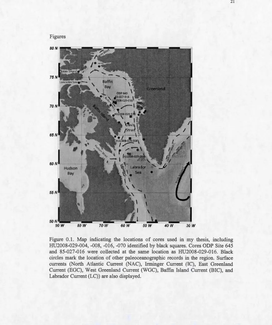
Figure 0.1. Map indicating the locations of cores used in my thesis, including
HU2008-029-004, -008, -016, -070 ... 21
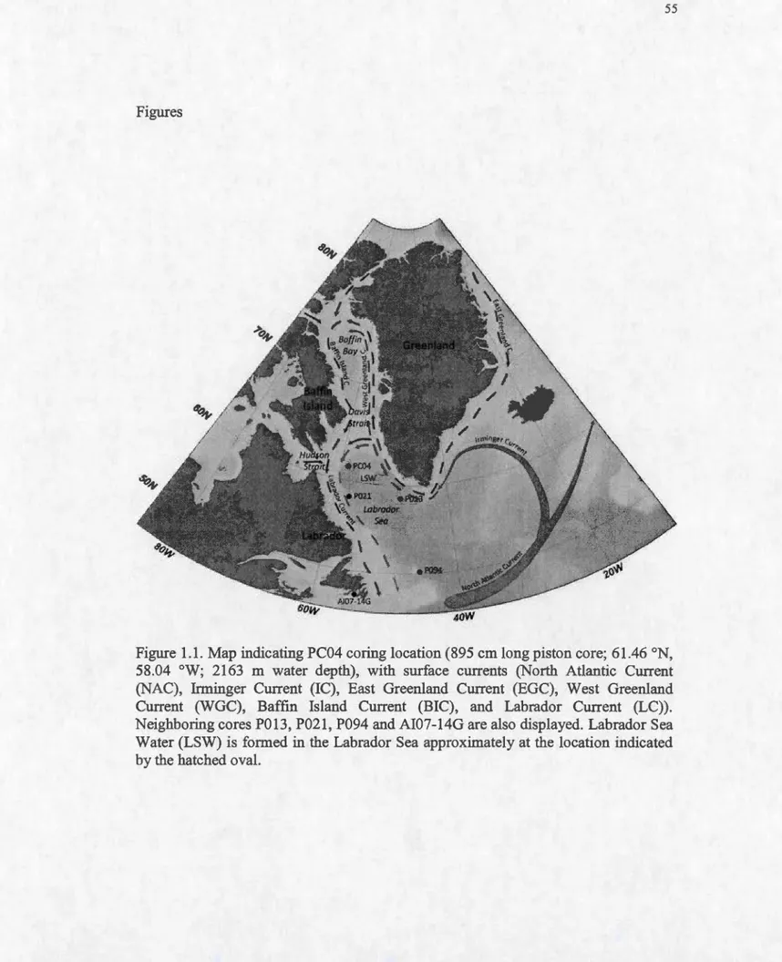
Figure 1.1. Map indicating PC04 coring location and currents ... 55
Figure 1.2. Age vs. depth relationship for core PC04 ... 56
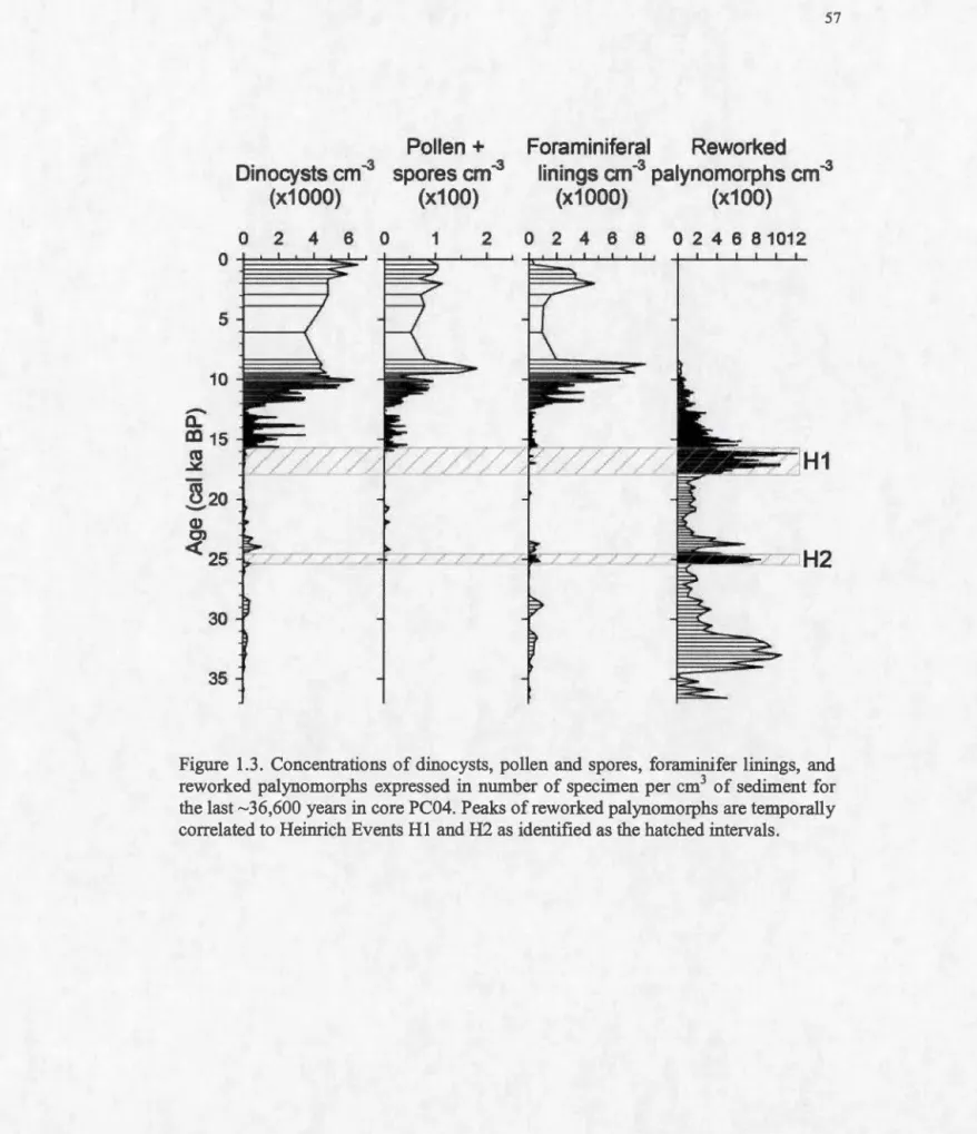
Figure 1.3. Concentrations ofpalynomorphs per cm3 ... 57
Figure 1.4. Relative abundance (percentage) of the main dinocyst taxa ... 58
Figure 1.5a. Reconstruction of sea surface conditions covering the past -36,600 years and the oxygen and carbon stable isotopes ofNpl.. ... 59
Figure 1.5b. Reconstruction of sea surface conditions for the interval spanning 16-8 ka and the oxygen and carbon stable isotopes ofNpl. ... 60
Figure 2.1. Map indicating the coring location ofPC16 ... 94
Figure 2.2. Assessment of possible bias in isotopie composition due to detrital carbonate ... 9 5 Figure 2.3. Carbon and oxygen isotopie composition (%o) of the 106-150, 150-250, and >250 !J.m size fractions Npl. ... 96
Figure 2.4. Biological, geochernical and sedimentological parameters collected in core PC16 ... 97
Figure 2.5. Carbon and oxygen isotopie composition (%o) of Npl and total micorfossil abundances in core 85-029-016 ... 98
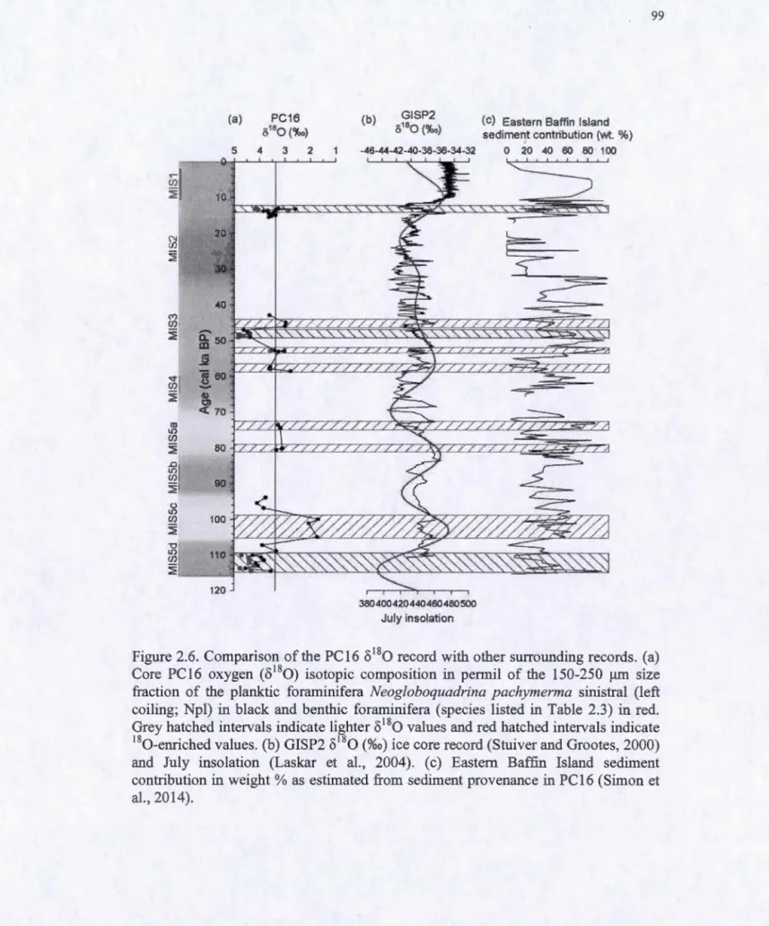
Figure 2.6. Comparison of the PC l 6 8180 record with other records ... 99
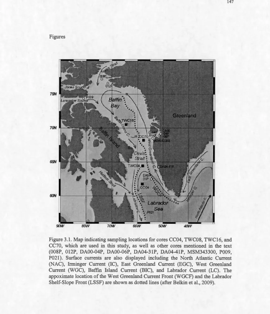
Figure 3.1. Map indicating sampling locations for cores CC04, TWC08, TWC16, and CC70 ... 147
Figure 3.2. Age vs. depth relationship for cores CC04 (a) and CC70 (b) ... 148
Figure 3.3a. Core CC04 - reconstruction of sea surface conditions from dinocyst assemblages and the weight percent coarse fraction ... 149
Figure 3.3b. Core CC04-concentrations & relative abundance ofdinocyst taxa ... 150
Figure 3.4a. Core TWC08 - reconstruction of sea surface conditions from dinocyst assemblages and the weight percent coarse fraction ... 151
Figure 3.4b.Core TWC08- concentrations & relative abundance of dinocyst taxa. 152 Figure 3.5a. Core CC70 - reconstruction of sea surface conditions from dinocyst assemblages and the weight percent coarse fraction ... 153
xi
Figure 3.5b. Core CC70 -concentrations & relative abundances of dinocyst taxa. 154 Figure 3.6a. Core TWC16 - reconstruction of sea surface conditions from dinocyst assemblages and the weight percent coarse fraction ... 155 Figure 3 .6b.Core TWC 16 -concentrations & relative abundances of dinocyst taxa.156 Figure 3.7. Reconstruction of sea surface conditions from dinocyst assemblages of cores CC70 and MSM343300 ... 157
Table 2.1. Replicate samples of oxygen and carbon isotopie composition (%o) the
150-250 )lm size fraction ofNpl. ... 100
Table 2.2. Oxygen and carbon isotopie composition (%o) of calcite in clean (uncontaminated) and dirty (contaminated) Npl ... 101
Table 2.3. Oxygen and carbon isotopie composition (%o) of Npl and benthic foraminifera ... 102
Table 2.4. Concentrations ofpalynomorphs per cm3 •..•...•.•••••••.•.••••.•••...••••••...• 106
Table 3 .1. List of cores used in this study with core location ... 158
Table 3.2. Radiocarbon dates for the cores in this study ... 159
APPENDIXB Table B.l. Core PC04 palynomorph concentrations ... 174
Table B.2. Core PC04 carbon and oxygen stable isotopes, percentage of IRD and carbonate ... 180
Table B.3. Core PC04 dinocyst species assemblage ... 186
Table B.4. Percentage of IRD in cores TWC04, TWC08, TWC70 ... 198
Table B.5. Core TWC04 palynomorph concentrations ... 200
Table B.6. Core TWC04 carbon and oxygen stable isotopes ... 202
Table B.7. Core TWC04 dinocyst species assemblage ... 204
Table B.8. Core TWC08 palynomorph concentrations ... 208
Table B.9. Core TWC08 dinocyst species assemblage ... 209
Table B. lü. Core TWC70 palynomoprh conccentrations ... 211
RÉSUMÉ
La baie de Baffm est une voie importante d'exportation d'eau douce de l'Arctique vers 1 'Atlantique Nord. Les exercices de modélisation climatiques suggèrent que le réchauffement climatique s'accompagnera d'une augmentation de l'exportation d'eau douce l'Arctique ce qui affecterait le taux de formation de la masse d'eau de la mer du Labrador (LSW) et la circulation océanique globale. L'étude paléocéanographique de la baie de Baffin est donc pertinente afin de prévoir l'impact des changements climatiques à des échelles régionale et globale. Dans ce contexte, l'objectif de la thèse est de reconstituer les conditions océanographiques et climatiques de cette région pendant le dernier cycle glaciaire-interglaciaire (- 115-0 ka). Plus précisément, il s'agit de documenter la variabilité spatio-temporelle de la circulation océanique, notamment les apports d'eau de fonte des glaciers pendant les épisodes de réchauffement.
Les chapitres présentés dans la thèse tentent de répondre à ces questions à partir de l'analyse de carottes sédimentaires. Le premier chapitre porte sur une séquence sédimentaire du nord-ouest de la mer du Labrador couvrant les derniers 36 000 ans. Le deuxième chapitre concerne une séquence du centre de la baie de Baffm enregistrant les derniers 115 000 ans. Enfm, le troisième chapitre porte sur la déglaciation et postglaciaire, soit les derniers - 15 000 ans dans le nord-ouest de la mer du Labrador, le détroit de Davis, et les régions est et centrale de la baie de Baffin. Les objectifs principaux poursuivis sont les suivants : (1) reconstituer les conditions de surface de l'océan, y compris les températures estivales et hivernales, la salinité, la productivité primaire et la couverture de glace de mer; (2) caractériser la variabilité temporelle de la température, de la salinité et du carbone inorganique dissous de la masse d'eau intermédiaire afin de retracer la stratification et la ventilation dans la colonne d'eau; (3) établir des relations entre les changements paléocéanographiques de la baie de Baffm et la circulation dans l'Atlantique Nord et le climat. Ces objectifs de recherche ont été atteints et nous avons pu retracer la chronologie des changements paléocéanographiques de la baie de Baffm au cours des derniers - 115 000 ans.
Pendant la majeure partie du dernier intervalle glaciaire, la baie de Baffm a été occupée par une couverture de glace continue. Cependant, une advection d'eau Atlantique par le détroit de Davis semble caractériser certains intervalles froids (stadiaires) et chauds (interstadiaires). Des valeurs élevées du 8180 des foraminifères planctoniques (Neogloboquadrina pachyderma senestres; Npl) et des foraminifères benthiques (> +4%o) suggèrent qu'une seule masse d'eau froide et salée d'origine
Atlantique était présente sous la couche de mélange lors des stades isotopiques Sd et une partie des stades 3 et de la transition 2/1. Une couverture de glace de mer pérenne a été déduite de la faible productivité de foraminifères et de l'absence de dinokystes. De faibles valeurs du 8180-Npl (+2,6 à +3,6%o) lors d'épisodes des stades Sc, Sa, 3 et lors de la transition 2/1 sont enregistrées à des niveaux également marqués par des abondances relativement élevées de dinokystes, ce qui laisse supposer la pénétration épisodique d'une masse d'eau Atlantique un peu plus chaude ou une ouverture occasionnelle du couvert de glace de mer. Pendant le dernier dernier maximum glaciaire et lors de la transition vers l'Holocène, le nord-ouest de la mer du Labrador était couvert de glace de mer tel qu'illustré par la faible abondance des dinokystes et des valeurs élevées du 8180-Npl. Les événements de Heinrich 1 et 2 ont y ont été marqués par des des faibles teneurs en
o
180 qui indiqueraient une production élevée de glace de mer. En raison de conditions froides et de la proximité de la calotte Laurentidienne, le B0lling-Allemd et le Dryas récent ne se sont pas accompagnés d'enregistrement particulier à une échelle régionale.La déglaciation, caractérisée par une diminution du couvert de glace de mer de pérenne à saisonnière, s'est établie progressivement du sud vers le nord, soit de la mer de Labrador vers la baie de Baffin. La séquence d'événements a été la suivante. De- 12 à 7,S cal ka BP, le nord-ouest de la mer du Labrador a connu un changement très important des conditions de surface, avec des températures d'été élevées (-11 °C) mais froides en hiver (- Ü0
C), une couverture de glace de mer de près de 3 mois par an et une faible salinité (-28) Les forts gradients thermiques saisonniers auraient été une conséquence de la forte stratification due aux apports d'eau de fonte de la calotte glaciaire laurentidienne. Dans le secteur est de la baie de Baffin, à environ 9,S cal ka BP, une augmentation de salinité de surface de 28 à> 32 et une diminution du couvert de glace de mer sont enregistrés, sans doute en relation avec le retrait des marges de la calotte glaciaire du Groenland, notamment dans Disko Bugt. Par la suite, plusieurs changements sont survenus à environ 7,S cal ka BP. Dans le nord-ouest de la mer du Labrador, les conditions interglaciaires actuelles se sont établies suite à l'augmentation de la salinité qui a atteint environ 34, s'accompagnant d'une augmentation des températures hivernales en dépit d'étés plus frais. Cette transition est associée à de moindres apports d'eau de fonte, une stratification réduite et une augmentation de la pénétration des masses d'eau de l'Atlantique Nord en surface. De telles conditions sont favorable à la convection hivernale et à la formation de la masse d'eau de la mer du Labrador (LSW), dont témoignent par ailleurs des valeurs élevées du
o
13C-Npl. Dans l'est de la baie de Baffin, le réchauffement de surface en hiver et des salinités plus élevée ont conduit à une forte réduction de la durée de la couverture de glace de mer et de la productivité primaire. Les enregistrements du centre de baie de Baffm indiquent également une advection accrue des eaux de l'Atlantique Nord en surface pendant le postglaciaire, mais avec une réponse fortement atténuée par rapport au secteur est. Ces résultats suggèrent de grandes fluctuations des conditions de surface marines à 1 'Holocène, différentes dansxv
les secteurs hauturiers et côtiers, mais étroitement contrôlées par le courant chaud de l'ouest du Groenland et froid de la Terre de Baffin.
Mots clés : paléocéanographie, paléoclimatologie, baie de Baffin, mer du Labrador, glaciaire, Holocène, dinokystes, foraminifères, isotopes de l'oxygène et du carbone
North Atlantic. Modeling forecasts of an increase in freshwater export driven by a warming Arctic may affect the rate of Labrador Sea Water (LSW) formation and global oceanic circulation. Investigating the paleoceanographic history of the Baffin Bay corridor is therefore relevant for forecasting potential climate impacts both regionally and globally. The focus of this thesis is to reconstruct the oceanographie conditions in this region through the last glacial cycle ( -115 ka), with emphasis on the spatio-temporal variability of ocean circulation through large scale climate oscillations, including meltwater outflow and warming temperatures during the de glacial.
Three research chapters address these issues using marine core sediment samples.
The frrst analyses a record spanning the last -36 ka from the northwest Labrador Sea,
the second records the last - 115 ka from central Baffin Bay, and the third correlates higher resolution records from a multiple-core transect from the northwest Labrador Sea, Davis Strait, and eastern and central Baffm Bay focusing on the last deglacial
and the Holocene (last -15 ka). Three main objectives were followed for each
research chapter: (1) reconstruct sea surface conditions including summer and win ter
temperatures (SST), summer salinity (SSS), productivity, and sea ice cover as they respond to changes in climate, the subsurface water mass, and meltwater input; (2)
characterize temporal variability in relative temperature, salinity, and dissolved
inorganic carbon of the subsurface water mass due to the advection of other water masses, changes in sea ice cover, and stratification and/or ventilation throughout the
water column, and; (3) spatially and temporally correlate changes in
paleoceanographic conditions among sites throughout the Baffm Bay corridor and with other records from the North Atlantic to identify associations with oceanic circulation and climate.
Results show that Baffm Bay remained completely ice covered during most of the last glacial interval. However advection of saline Atlantic water entered Baffm Bay through Davis Strait during both cooler (stadial) and warmer (interstadial) intervals.
High 8180 values of both planktic Neogloboquadrina pachyderma left-coiled (Npl)
and benthic foraminifera (>+4%o) suggest a single cold, saline Atlantic water mass was present during Marine Isotope Stages (MIS) 5d, 3, and the MIS 2/1 transition.
Continued perennial sea ice cover was inferred from low productivity and the absence
of dinocysts. Low 8180-Npl values (+2.6 to +3.6 %o) were present during MIS Sc, Sa, 3 and the MIS 2/1 transition. The low values, coupled with occurrences of dinocysts, suggest the Atlantic water mass was slightly warmer, or affected by the addition of
X VIl
isotopically light brilles through heavy sea ice production during occasional seasonally open water. The northwest Labrador Sea was also cold and perennially ice
covered during MIS 2 and the MIS 2/1 transition, as documented by low dinocyst
abundance and high 8180-N~l values. The termination of Heinrich Events 1 and 2
were recorded with light-8 80 excursions indicating heavy ice production. The
B0lling-Aller0d and Younger Dryas were not recorded or weakly recorded, likely due
to close proximity to Laurentide lee Sheet (LIS).
The deglaciation, characterised by the shift from perennial to seasonal sea ice cover,
occurred diachronously northward through the Baffin Bay corridor. From ~12 to 7.5
cal ka BP, the northwest Labrador Sea experienced a dramatic shift to warm summer ( ~ 11 °C) but cold win ter ( --û0
C) sea surface temperatures (SST), sea ice co ver during about 3 months per year, and low sea surface salinity (SSS) (~28), likely due to enhanced subsurface inflow of North East Atlantic Deep Water. The large seasonal gradients in temperature were due to a strongly stratified upper water layer in relation to meltwater supply from the LIS. At around 9.5 cal ka BP in eastern Baffm Bay, SSS increased significantly (28 to > 32) and the breakup of perennial sea ice began as the Greenland lee Sheet retreated into Disko Bugt. Severa! changes occured throughout
the corridor at about 7.5 cal ka BP. In the northwest Labrador Sea, postglacial
conditions were established after SSS had progressively increased to about 34, and winter SSTs became warmer and summers cooler. This was facilitated by the reduced water mass stratification by the retreat of the LIS and enhanced penetration of North
Atlantic water, all contributing to winter convection and Labrador Sea Water
formation which is reflected in increased 813C-Npl values (i.e., enhanced ventilation). In eastern Baffin Bay, warming and more importantly, higher salinity conditions, led to a strong reduction in the duration of the sea ice cover and to significant primary productivity. Central Baffm Bay likely evolved with the eastern sector of the Bay as it responded to the advection of North Atlantic waters, but with a strongly attenuated response. This diachronous evolution toward modem sea surface conditions in the Baffm Bay corridor was likely due to limited North Atlantic advection through the Davis Strait sill. These postglacial records demonstrate large fluctuations in sea surface conditions independent to the variability of surrounding coastal records, but are likely controlled by the relative strengths and shifts of the warmer West Greenland Current and colder Baffm Island Current.
Key words: paleoceanography, paleoclimatology, Baffin Bay, Labrador Sea, glacial,
Contemporary decline in Arctic sea ice extent is related to Arctic warming within recent decades, as the result of thermodynamic and sea ice-albedo feedback (cf. Stroeve et al., 2012). The increased sea-ice melting, along with increases in freshwater inputs from land, the Pacifie Ocean, and precipitation have greatly increased the amount of freshwater to the Arctic Ocean (Serreze et al., 2006). This has lead to enhanced overall freshwater export, as demonstrated by a decreasing salinity of the North Atlantic, which may affect the Atlantic Meridional Overturning Circulation (AMOC) (Curry and Mauritzen, 2005; Peterson et al., 2006; Dickson et al., 2007; Sutherland et al., 2009). Within the AMOC, deep water masses such as North Atlantic Deep Water (NADW) are created when relatively warm, but saline surface waters of the North Atlantic Current (NAC) enter the Greenland, Iceland and Norwegian (GIN) Seas and also the Labrador Sea and loose buoyancy (Fig. 0.1). Deep convection in the water column is caused by the sinking of a dense upper water mass. The densification is caused by warm surface waters losing heat to the atrnosphere, or when brines are released during sea ice formation (Curry and Mauritzen, 2005).
Increasing greenhouse gas concentrations may affect the AMOC in two dominant processes. Increasing air temperatures will reduce the cooling (densification) of the sea surface. Also, an increase in freshwater will decrease the sea surface salinity, thereby reducing the density. Debates on the effects of climate change on the AMOC focus on the magnitude of these triggers and the reaction time of these systems (Curry
2
and Mauritzen, 2005). Coupled atmosphere-ocean General Circulation Models
(GCMs) are used to forecast the effects of clirnate change on the AMOC (Jahn and
Rolland, 2013). In sorne modeling scenarios, cessation of the AMOC is projected
under conditions of large freshwater influx due to the melting of Arctic ice
(Greenland lee Sheet, permanent sea ice) (Driesschaert et al., 2007), while others
suggest non linearity (Swingedouw et al., 2009). GCMs have also been used to
understand changes in past clirnate and oceanic circulation, specifically illustrating their large-scale fluctuations during the last glacial cycle and the roles of freshwater
and clirnate in changing the AMOC (Manabe and Stouffer, 1995; Clark et al., 2007).
Currently, the amount of freshwater exiting the Arctic is increasing, and a significant proportion is exiting through the Canadian Arctic Archipelago (CAA) via Lancaster
Sound, Jones Sound, and Nares Strait (Serreze et al., 2006; Dickson et al., 2007;
Curry et al., 2011), which collect in Baffin Bay and pass through Davis Strait into the
Labrador Sea (Fig. 0.1). Models suggest that Arctic freshwater output through the
western route (i.e., west of Greenland) is colder and fresher than the eastern output
(Fram Strait; Aksenov et al., 2010). Freshwater forcing through the Baffin Bay
corridor is required in models to reconstruct decreases in sea surface salinity resulting
in decreased convection in the Labrador Sea (Goosse et al., 1997; Wadley and Bigg,
2002; Cheng and Rhines, 2004; Wekerle et al., 2013). Labrador Sea Water (LSW) is
an important component of the modem AMOC. It is an intermediate water mass
which contributes to NADW (Yashayaev and Loder, 2009 and references therein).
LSW is formed when cold winter surface air temperatures over the Labrador Sea cool a western branch of the warm, saline North Atlantic Drift (West Greenland
Current-WGC), which then sinks due to increased density (Lazier, 1973). The rate of LSW
formation is variable and responds to both changes in salinity and atmospheric
circulation, which affect stratification and therefore convective mixing. Thus,
the Labrador Sea (hereafter described as the Baffm Bay corridor) and warmer climate may modify the LSW production rates. Such changes were observed during the Great
Salinity Anomaly in the late 1960s, early 1970s, and 1990s (e.g., Dickson et al.,
1988; Gelderloos et al., 2012). In the context of extreme climate shifts, it is relevant
to investigate the past history of the sea surface conditions, the subsurface water
mass, and sea ice formation in relation to freshwater fluxes and climate from Baffin Bay to the Labrador Sea. These results, based on past conditions, contribute baselines to forecasting the potential impacts of future freshwater fluxes and increasing sea surface temperature on the formation of LSW and variability of the AMOC.
0.1.1 The northwest Labrador Sea
Throughout the last glacial interval (the last ~ 115 ka), the Labrador Sea has evolved
from being cold and mainly ice covered to warm and mainly ice free (de Vernal and
Hillaire-Marcel, 2000; de Vernal et al., 2000; de Vernal et al., 2005). A few
paleoceanographic records (black circles Fig. 0.1) have been reconstructed from
various proxies including foraminiferal species assemblages (e.g. Bilodeau et al.,
1994; Seidenkrantz et al., 20 13), the oxygen and carbon stable isotopes of
foraminiferal tests ( e.g. Hillaire-Marcel et al., 1994; Hillaire-Marcel and Bilodeau,
2000; Rasmussen et al., 2003; Seidenkrantz et al., 2013), and sea surface
reconstructions based on dinoflagellate cyst assemblages (e.g. de Vernal et al., 1994,
2000, 2001; Rochon and de Vernal, 1994; Levac and de Vernal, 1997; de Vernal and
Hillaire-Marcel, 2000; Solignac et al., 2004; Hillaire-Marcel et al., 2007). Those
studies have illustrated that the Labrador Sea bas been greatly influenced by advances and retreats of the northeastern margin of the Laurentide lee Sheet (LIS) and by the
advection of North Atlantic waters. For example, increased sea ice cover occurred
4
while the 8.3 cal ka BP-drainage layer event is not easily recognizable in sea surface reconstructions.
The northem Labrador Sea is however particularly interesting because the Hudson
Strait was one of the main sources for sediment, ice and meltwater supply during the
glacial period and deglaciation of the LIS (Andrews and Tedesco, 1992; Andrews et al., 1994). However, areas north and east of the outlet of Hudson Strait do not al ways receive such deliveries as in the case of HE 3 (Stoner et al., 1996; Rashid et al., 2003) and possibly the 8.3 cal ka BP-drainage layer event (Hillaire-Marcel et al., 2007).
Few reconstructions have been undertaken in the northwest Labrador Sea, near the
outlet of Hudson Strait. Previous reconstructions include bottom water conditions
during periods of LIS flux from foraminiferal abundances (Jennings, 1993; Jennings
et al., 1996, 1998) and changes to the intermediate water layer during Heinrich Events from planktic foraminiferal oxygen isotopes (8180; Rashid and Boyle, 2007). However reconstructions of sea surface conditions have yet to be investigated.
0.1.2 Baffm Bay
Paleoceanographic reconstructions from sediment cores in Baffin Bay (black circles
Fig. 0.1) can be divided into two groups. The frrst consists of records collected from shallow (< 1000 rn) shelf areas surrounding Baffin Bay where high sedimentation rates (e.g. 100 cm ka-1) are linked to coastal and glacial erosion. This creates records with high temporal resolution of deglacial and Holocene sediments that mainly reflect
local variability in atmospheric and oceanic circulation and meltwater discharge
(Seidenkrantz et al., 2008; Erbs-Hansen et al., 2013). Most of these paleoceanographic studies used foraminiferal abundances as proxies of subsurface-bottom water mass properties, that are in tum associated with the relative strength of Atlantic vs. Arctic water in Baffm Bay (e.g. Ostennan and Nelson, 1989; Levac et al.,
2001; Seidenkrantz et al., 2007, 2008, 2012; Knudsen et al., 2008; Ledu et al., 2008;
Lloyd et al., 2005, 2007; Mudie et al., 2006; M0ller et al., 2006; Moros et al., 2006;
Andresen et al., 2011; Pemer et al., 2013; Erbs-Hansen et al., 2013; Jennings et al.,
20 13). However, sorne records used dinoflagellates cysts as pro xi es to reconstruct sea
surface conditions since the deglaciation ( e.g. Levac et al., 2001; Hamel et al., 2002;
Ledu et al., 2008; Seidenkrantz et al., 2008; Andresen et al., 2011; Ouellet-Bernier et
al., 20 14). Other used diatoms as proxies for sea surface conditions ( e.g. Williams,
1990; Moros et al., 2006; Knudsen et al., 2008; Ren et al., 2009). Sorne of these
records document the large meltwater inputs from the deglaciation of the LIS and Innuitian lee Sheet (IlS), or the ice margin retreat and continued discharge from the Greenland lee Sheet (GIS). Most of these coastal sites record local to regional ocean
variations during the Holocene.
The second group of paleoceanographic records previously analysed were collected from the deepest, central areas of Baffm Bay. Ocean Drilling Project (ODP) Site 645
(Leg 105; Baldauf et al., 1989) extends back to the early Miocene. There are also
piston cores spanning the last glacial cycle (Fig. 0.1; Aksu and Piper, 1979; Aksu,
1981, 1983; de Vernal et al., 1987), including site survey core 85-027-016 for ODP
Site 645 (Fig. 0.1; Hillaire-Marcel et al., 1989; Scott et al., 1989). The primary
challenge in analysing marine sediments from Baffm Bay is the difficulty in
establishing a chronostratigraphy. This is caused by two factors. Sediment delivery
from surrounding ice sheets active during glacial periods cause variable
sedimentation rates in this region (Simon et al., 2012 and references therein).
Additionally, the Jack of calcareous foraminifera precludes radiocarbon analyses or
the establishment of a
o
180 stratigraphy. However, Simon et al. (2012) recentlyproposed a chronostratigraphy spanning the last 115 ka based on detailed
6
Paleoceanographic reconstructions based on the 8180 of planktic foraminifera and
dinoflagellate cyst assemblages over the last glacial interval have been attempted on severa! deep Baffin Bay cores despite the chronological uncertainty and interpretation
challenges (Aksu, 1981, 1983; Mudie and Aksu, 1984; de Vernal et al., 1987;
Hillaire-Marcel et al., 1989; Scott et al., 1989). Intervals containing little to no microfossils prevent continuous records that are difficult to interpret. Low concentrations of rnicrofossils have been explained by dilution due to high sedimentation rates (Scott et al., 1989), low productivity due to harsh, ice covered
conditions and low salinities (Hillaire-Marcel et al., 1989), carbonate dissolution
(Aksu, 1983), or a combination of these factors (Hillaire-Marcel et al., 1989).
Carbonate dissolution in Baffm Bay characterizes Holocene sediments collected from depths > 900 rn (Aksu 1983; Osterman and Nelson, 1989; de Vernal et al., 1992;
Schroeder-Adams and Van Rooyen, 2011; Steinhauer, 2012). This greatly hindered
the study of circulation in Baffm Bay throughout the glacial stage. There were also
other limitations that have since been discovered and/or improved since the 1980s. In
those days, isotopie analyses required a sample size >50 foraminiferal tests. Smaller sample sizes could have introduced analytical bias, while large samples could have been drawn from severa! planktic populations due to the low sedimentation rates and
due to the presence of reworked foraminifera (Hillaire-Marcel et al., 1989). More
importantly, any detrital carbonate material, which is found in abundance within
Baffm Bay sediments (Hiscott et al., 1989), remaining within foraminiferal tests
could bias their isotopie composition and result in rnisleading values (Hodell and Curtis, 2008). Lastly, interpretations of a planktic-8180 signal from this polar to subpolar environment can not be directly correlated with the global marine isotope stratigraphy, notab1y because of the isotopie imprint of sea ice formation (Hillaire-Marcel and de Vernal, 2008). The early planktic-8180 records from Baffm Bay revealed large range in values, initially interpreted as glacial-interglacial oscillations (Aksu, 1983; Aksu and Mudie, 1985). The low planktic-8180 values have since been
interpreted as the result of episodic depletions due to meltwater inputs (de Vernal et
al., 1987). Most recently, this pattern is thought to reflect the sinking of isotopically
depleted brines during sea ice production along the pycnocline to Npl habitat depth
(Hillaire-Marcel and de Vernal, 2008). Therefore, an established chronostratigraphy
along with the recognition of these limitations will allow for the adaptation of different techniques and interpretations in order to further pursue paleoceanographic
reconstructions of Baffin Bay.
0.2 Statement of problem and objectives of this study
The Baffm Bay corridor is currently an important pathway for Arctic freshwater
export and global oceanic circulation. These processes are expected to change in the
near future. Information on responses to changes in the past glacial-to-interglacial
periods provides insight on future dynamics. The focus is set here on deeper, more
central sites as a means to generate records of large-scale changes in oceanographie conditions that predominantly vary in response to the regional ocean dynamics rather
than to coastal processes. Also, my assessment of the limitations of
paleoceanographic research in a harsh, Arctic environment such as Baffin Bay and
analysing the data with new methods and a wider suite of potential mechanisms,
provide a precedent for other areas.
The focus of this thesis is thus to reconstruct the oceanographie history of the Baffm
Bay corridor (Baffin Bay, Davis Strait, northwest Labrador Sea) through the last
glacial cycle ( ~ 115 ka). More specifically, my goal is to document variability in
oceanographie conditions including temperature, salinity, sea ice cover, freshwater
fluxes and the occurrence of multiple water masses due to the effects of large scale
8
throughout the last glacial cycle will be addressed. These include the last five marine isotope stages, the Greenland stadials and interstadials, Heinrich Events, intense meltwater incursions, increasing insolation, climate events of the recent deglacial interval ( e.g. Belling-Allemd, Young er Dryas, drainage of glacial lake Agassiz), and the millennial scale climate oscillations of the Holocene (e.g. Mid-Holocene
optimum, Medieval Warm Period, Little lee Age). The following three main
objectives will be applied to various sites within the Baffin Bay corridor and form the
basis of three research chapters organized by location and chronology:
Objective 1: Reconstruct sea surface conditions including summer and winter
temperatures, salinity, productivity, and sea ice cover as they respond to changes in climate, the subsurface water mass, and meltwater input. Objective 2: Characterize temporal variability in relative temperature, salinity, and
dissolved inorganic carbon of the subsurface water mass due to the advection of other water masses, changes in sea ice cover, and stratification and/or ventilation throughout the water column.
Objective 3: Spatially and temporally correlate changes in paleoceanographic
conditions among sites throughout the Baffin Bay corridor and with other records from the North Atlantic to identify associations with oceanic circulation and climate.
The specifie goals required to achieve these objectives are to: (1) use dinoflagellate cyst species assemblages to reconstruct past sea ice cover, sea surface temperature and salinity, (2) set oxygen isotope records in planktic and benthic foraminifera to recreate relative changes in temperature and salinity of the mesopelagic and bottom water masses and relative amounts of sea ice formation, (3) set carbon isotope records
in plank:tic and benthic foraminifera to identify sources of the mesopelagic and bottom water masses as well as productivity, nu trient supply, and ventilation of water masses, ( 4) establish chronologies or temporally cons train oceanographie changes
using the results from goals 1 through 3, as well as 14C dating, ice-rafted detritus and
detrital carbonate contents.
0.3 Geographie and hydrographie setting
Baffm Bay is a semi-enclosed, oblong basin approximately 1450 km long and
between 110 and 650 km wide (690,000 km2 surface area; Fig. 0.1 ). It is bordered by
Greenland to the east with a wide shelf extending ~ 150 km, Baffin Island to the west
with a narrower shelf extending ~35 km, and the CAA to the north, ali with relatively
steep slopes to the sea floor. Baffin Bay reaches a maximum water depth of 2136 rn, and connects to both the Arctic and Atlantic oceans across sills. Although they restrict deep water flow, the sills permit cold Arctic surface waters to enter Baffin Bay from the north via Lancaster Sound (55 km wide, 125 rn deep), Jones Sound (30
km wide, 190 rn deep), and Nares Strait (~40 km wide, ~220 rn deep) in the north.
They also permit warmer intermediate waters from the Atlantic to enter from the
south via Davis Strait (640 rn depth). During the last glacial maximum, Baffin Bay
was surrounded by the Innuitian, Laurentide and Greenland lee Sheets which
extended onto the shelves (Briner et al., 2003, 2006; Dyke 2004;
6
Cofaigh et al.,2013; Funder et al., 2011). This may have greatly impeded flow into or through
Baffm Bay during this time. Davis Strait connects Baffin Bay to the Labrador Sea,
which expands along the Northwest Atlantic mid-ocean channel reaching ~3500 rn
10
km on average, and to the northeast by Greenland with a narrow shelf extending ~50
km.
Northward flowing warm high-salinity Atlantic waters and southward flowing cold low-salinity Arctic waters form a counter clockwise gyre throughout the Baffm Bay corridor (Fig. 0.1) (see Bourke et al., 1989; Buch, 2000, 2008; Cuny et al., 2002, 2005; Tang et al., 2004; Ribergaard, 2008; Münchow et al., 2014 for details listed
below). Along the West Greenland shelf, the West Greenland Current (WGC) carries
cool, less saline Arctic water from the East Greenland Current (temperature, T, ~ -1.8°C, salinity, S :S 34.5) that has been slightly warmed by Atlantic water (T ~ 4.5°C, S :S 34.95) which is a western branch of the Irminger Current (IC) that flows within
30 km of the West Greenland slope. Therefore the WGC consists of an upper 100 rn
of cooler, less saline water (T ~ 2.3°C, 32 :S S :S 33) above a warmer more saline water layer (T ~ 1.6°C, S ~ 34.4), which both flow north along eastern Davis Strait).
Once the WGC reaches northern Baffm Bay and turns west, it (upper 300 rn, T ~
-1.5°C, S :S 34) mixes with cold, less saline Arctic water that enters via the Canadian
Arctic Archipelago (Nares Strait, Lancaster Sound, and Jones Sound) and becomes
the Baffm Island Current (BIC). Baffin Bay Intermediate Water consists of the Irminger component of the WGC that has recirculated in Baffm Bay and sorne warmer Arctic Intermediate water of Atlantic origin that passes over the sills ofNares Strait. Baffm Bay Deep and Bottom waters cool with depth. The BIC flow south along the Baffm Island coast on the continental shelf and slope through Davis Strait
into the northwest Labrador Sea. Finally, the BIC mixes with Arctic water exiting
Hudson Strait to form the Labrador Current (LC) (T ~ -l.5°C, S :S 34) which flows along the eastern Canadian shelf and upper slope. The calder, less saline surface layer of the LC overlies a bran ch of the W GC that has extended westward near Davis S trait and circulated through the gyre. Below the LC lies the Labrador Sea Water (LSW; T
~ 3.0°C, S ~ 34.9) which is formed by vertical convection due to the sinking of dense
above the North East Atlantic Deep Water and the Denmark Strait Overflow Water (Yashayaev, 2007). Sea ice cover across the 30° latitudinal range along the Baffin Bay corridor is qui te variable, ranging from 0 to > 10 months per year or concentration ranging from 0 to about 90% from fall through spring. Sea ice formation begins in September in northwest Baffm Bay and extends southward reaching nearly complete cover by March (Wang et al., 1994; Tang et al., 2004), occasionally reaching the northwest Labrador Sea. The warm WGC prevents sea ice formation along the southwestem Greenland coast and reduces the extent in eastern Baffm Bay. The cold and stratified LC fosters sea ice growth along the Newfoundland and Labrador shelf. Sea ice begins to melt in April in northern Baffm Bay's North Water Polynya and the Greenland coast moving westward until ice free conditions occur during August or September. The strong seasonality in air temperatures and wind patterns produce the large interannual variability in sea ice cover (Tang et al., 2004).
0.4 Materials
The cores used to address the research objectives are from the HU2008-029 emise aboard the CCGS Hudson in 2008 (Fig. 0.1; Campbell et al., 2009). Piston and associated trigger core HU2008-029-004 (PC04 and TWC04) were collected off the Southem Baffm Island shelf in the northwestem Labrador Sea (61.46 °N, 58.04 °W) at a water depth of 2163 m. Core PC04 and TWC04 are 896 and 56 cm in length, respectively. Piston and trigger core HU2008-029-016 (PC16 and TWC16) were collected from deep Baffin Bay (70.77 °N, 64.66 °W) at a water depth of 2063 m. The coring site is in close proximity to cores ODP Site 645 and 85-029-16, which is useful for correlating with previous records. Cores PC16 and TWC16 are 741 and 155 cm in length, respectively. Core PC16 was previously described by Simon et al. (2012), and core TWC16 by Steinhauer (2012). Piston and trigger core
HU2008-029-12
070 (PC70 and TWC70) were collected off western Greenland (68.23 °N, 57.62°W) at a water depth of 444 m. Cores PC70 and TWC70 are 245 and 208 cm long, respectively. PC70 was previously described by Jennings et al. (20 13). Piston and trigger cores HU2008-029-008 (PC08 and TWC08) were collected south of Davis Strait (64.39 °N, 58.13 °W) at a water depth of 858 m. Cores PC08 and TWC08 are 964 and 156 cm in length, respectively. Core PC08 was previously described by Andrews et al. (2014). Due to difficulties in establishing a chronology, PC08 was not used in this study.
0.5 Methodology
0.5.1 Chronology
Establishing the chronostratigraphy should be the first step in paleoceanographic studies from sediment cores. Radiocarbon (14C) dating of calcareous foraminifera is the most common method in the northwest Atlantic. The most appropriate sample to use is a single species of planktic foraminifera from within a narrow size fraction to best represent a single foraminiferal population. Other methods of temporal correlation including paleomagnetic data and 8180 stratigraphies will also be used.
The presence of calcareous foraminifera within northwest Labrador Sea sediments (Jennings et al., 1996) will allow for a chronostratigraphy based on 14C dating. However, the presence of Heinrich Events, as determined by an abundance of coarse grained sediments with detrital carbonate content, will also be considered since they have been extensively dated in the area (Andrews and Tedesco, 1992; Andrews et al., 1994; Hillaire-Marcel et al., 1994; Stoner et al., 1995, 1996; Rashid et al., 2003).
PC16 based on magnetic, mineralogical, and physical properties of the sediment has provided an age model spanning the last 115 ka (Simon et al., 2012). Previous attempts were based on the correlation of 8180 records which were discontinuous due to the lack of calcareous foraminifera in sorne intervals (Aksu and Piper, 1979; Aksu, 1981, 1983; Mudie and Aksu, 1984; de Vernal et al., 1987; Hillaire-Marcel et al., 1989; Scott et al., 1989). Calcium carbonate dissolution due to low carbonate saturation states (Azetsu-Scott et al., 201 0) and oxidation of organic matter produced in the North Water Polynya eliminates calcareous foraminifera for radiocarbon dating as a postglacial stratigraphie tool in Baffm Bay and Davis Strait (Aksu 1983; Osterman and Nelson, 1989; de Vernal et al., 1992; Schroeder-Adams and Van Rooyen, 2011 ). The paleomagnetic properties of this interval also problematic and not used in the age mode! (Simon et al., 20 12). 1 will therefore use the palynological analyses to tentatively correlate Holocene records.
0.5.2 Paleoceanographic proxies
Severa! proxies are used for the paleoceanographic reconstructions of the Baffm Bay corridor in order to recreate conditions throughout the water colurnn. Palynological analyses and the carbon and oxygen stable isotope analyses of planktic and benthic foraminifera will be combined to identify three (or potentially more) water masses when possible. Reworked palynomorphs and ice rafted debris and detrital carbonate content will complement interpretations on sedimentation and oceanographie processes. These proxies are described below, along with the method of analysis.
14
0.5.3 Foraminiferal stable isotopes (8180 and 813C)
Foraminifera are single-celled organisms whose tests are preserved within ocean sediments given the proper conditions. There are severa! forms of foraminifera:
epibenthic (living on sea floor sediments), endobenthic (living within sea floor
sediments), other spec1es of benthic foraminifera living on substrate or other organisms, and planktonic species living in the water column. Changes in the oxygen
stable isotope values (8180) of calcareous epibenthic and planktic foraminifera reflect
changes in temperature, salinity and the 8180 of the water in which the test was
precipitated. Therefore oceanographie changes due to climate variability, large
isotopically depleted meltwater supply, increase in isotopically depleted brines during
sea ice formation, or an inflow of different water masses may be observed.
Changes in the carbon stable isotope values (813C) of benthic and planktic calcareous
foraminifera reflect the values of the dissolved inorganic carbon (DIC) in the water where they precipitate their carbonate test, and affected by vital (biological) effects and kinetic isotope fractionation. Increased photosynthesis within surface waters
sequesters isotopically depleted C02, which increases DIC and planktic foraminiferal
813C and can therefore reflect increased primary productivity during a shift to
seasonally ice covered conditions within a paleorecord. Increases in freshwater influx
during periods of warmer climate boast the influx of depleted, terrestrially-derived
DIC (Ravelo and Hillaire-Marcel, 2007). Increased respiration due to an influx of
organic matter to the sediment surface negatively fractionates C02 (DIC) producing
decrease in benthic 813C. Bottom water circulation is also traced with changes in the
813C of benthic foraminifera which increases due to increased ventilation and
To determine variation rn water temperature, salinity, primary productivity, and
therefore changes in water mass characteristics and origin, the 8180 and 813C are
analysed on the most abundant and common planktic and epibenthic species through
each core, when possible. The planktonic foraminifer Neogloboquadrina pachyderma
left-coiled (Npl) is polar species found in Arcitc waters (e.g., cf. Kucera, 2007) and
within the Baffm Bay corridor (e.g. Hillaire-Marcel et al., 1989; Hillaire-Marcel et
al., 1994). Npl most commonly lives in cold saline (~34) waters in 50-250 rn water
depth along the pycnocline (Bé and Tolderlund, 1971; Hilbrecht, 1996; Carstens et
al., 1997; Volkmann and Menshc, 2001; Sirnstich et al., 2003; Pados and Spielhagen,
2014). They are also influenced by food availability living in the chlorophyll
maximum (upper 50 rn) under permanent ice cover (Volkmann and Mensch, 2001;
Pados and Spielhagen, 2014; Xiao et al., 2014). Npl stratify with size (shell density)
and calcify at different depths within the water column (Bauch et al., 1997;
Volkmann, 2000; Volkmann and Mensch, 2001; Hillaire-Marcel et al., 2004; Xiao et
al., 2014). Samples can be analysed from different size fractions ofNpl (e.g. 106-150
!J.m, 150-250 !J.ill, and >250 !J.m) to identify temperature-salinity (i.e., density)
gradients within the intermediate (mesopelagic) water (Hillaire-Marcel et al., 2004).
However caution during interpretation is required due to changes in metabolic
activity in older stages (Volkmann and Mensch, 2001) and depth of habitat (Xiao et
al., 2014).
The most common species of benthic species throughout a core are analysed where
possible. If low numbers persist, all size fractions will be used although sorne effect
on the isotopie composition cannot be totally discarded (Barras et al., 2010). No
correction for global ice volume or vital effects are made on the benthic 8180 and
813C since the results are used to document relative changes in a water rnass within
16
0.5.4 Palynology
Four groups of palynomorphs are utilised as paleoceanographic proxies. The frrst and
foremost are dinoflagellate cysts, or dinocysts, which are composed of resistant
organic compound protecting the dinoflagellate cell during the course of their
reproductive cycle. Dinoflagellates can be either photo trop hic (photosynthetic) or
heterotrophic (preying mainly on diatoms and ciliates), blooming in well lit,
productive surface waters (upper 50 rn). Unlike dissolvable calcareous microfossils (foraminifera), these cysts can be well preserved in marine sediments from all environments. Instances of poor preservation can occur with certain heterotrophic
species susceptible to degradation due to oxidation (Zonneveld et al., 1997, 2001,
2007). Although potentially comprised of samples spanning many years (1 to 1000)
of dinocyst flux, the dinocyst assemblage of the marine surface sediments
corresponds to the cyst-forming dinoflagellate assemblage in the overlying surface
waters (de V emal and Roc hon, 2011 ). The dinocyst species assemblage is therefore
related to sea surface temperature, sea surface salinity, sea ice conditions, and
primary productivity. The distribution pattern and abundance of dinocysts in marine
sediments relative to various sea surface conditions is well known, and a database
(http://www.geotop.ca) of these relationships is continuously increasing, especially in
remote locations of the Arctic (de Vernal et al., 2001, 2005, 2013; Radi and de
Vernal, 2008). This database is then applied in transfer functions using the modem analogue technique (MAT) to each sample through the core, to pro duce a record of the sea surface conditions through time. Therefore the reconstructed sea surface conditions include sea surface temperatures (SST) in both summer and winter,
summer sea surface salinity (SSS), months per year of sea ice cover with a
concentration> 50 %, and productivity in gC m-2. The data are initially manipulated
MAT using the scripts prepared by Joel Guiot (CEREGE, France) and the procedure
described by de Vernal et al. (2005).
0.5.5 Pollen and spores
The presence of fresh terrestrial palynomorphs, which include pollen and spores,
indicate material has been transported to marine sediments by ice rafting, ice
meltwater, runoff, wind, and currents. Since the cores used in this project are
relatively far from the coast, the presence of modem (fresh) pollen and spores is an indication of vegetation on adjacent land and subsequent hydrodynamic or
atmospheric transport.
0.5.6 Reworked (fossil) palynomorph
The presence of reworked (fossil) palynomorphs, including dinocysts, pollen, spores,
and acritarchs in mid-high latitude marine sediments is due to glacial erosion,
transport, and meltwater. An abundance of reworked palynomorphs in Baffm Bay and
the northwest Labrador Sea during the last glacial period is therefore an indication of
glacial activity of surrounding lee Sheets (Laurentide, Innuitian, and Greenland). The
reworked palynomorphs within Heinrich Events are likely eroded from the
Paleozoic-Mesozoic sedimentary formations of the Canadian Arctic and West Greenland (e.g.,
Hiscott et al., 2001) and deposited with ice rafted debris or meltwater flow within the
18
0.5.7 Foraminiferal organic linings
The organic linings of benthic foraminifera are often found among the palynomorphs. They remain preserved in sediments after the carbonate test has dissolved (de Vernal
et al., 1992). Dissolution occurs due to increased dissolved C02 in surface waters
from increased C02 in the atmosphere, high DIC (HC03-, C03-3) through respiration
of organic matter causing an increase in pH, and to low calcium carbonate (CaC03)
saturation states (Azetsu-Scott et al., 2010) which are a function of temperature,
salinity and pressure. Therefore carbonate dissolution is ubiquitous to cold, deep
Arctic environments due to ice melt, reduction in sea ice cover which increases co2
sequestration and primary productivity. Concentrations of benthic foraminiferal organic 1inings are thus a measure of the amount of carbon flux to the sea floor by proxy ofbenthic production (Rochon and de Vernal, 1994), sea ice cover and primary productivity in surface waters (de Vernal et al., 1992), and possibly the inflow of
Pacifie derived Arctic water (Azetsu-Scott et al., 2010).
0.5.8 Ancillary parameters
There are other sedimentological parameters used m conjunction with
micropaleontological proxies to provide additional inforamation on the hydrography
and sedimentary influx. These ancillary parameters include weight percent of ice
rafted debris (% IRD) as estimated by the weight percent fraction > l 06 ).lm, and
weight percent carbonate which is calculated from the weight percent inorganic
carbon (% CinorJ· IRD is produced by ice sheets or ice streams that have ground up
sediments at the base, and calved off icebergs along the ice margin. The icebergs then
within. The presence of IRD is not only an indicator of cooler times with ice sheet advance and iceberg calving, but also the presence of surface waters conducive to the movement of icebergs (no permanent ice pack). In this thesis, the > 106 IJ.m fraction mostly contains detrital material and possibly a low abundance of light biological remains (microfossils) making this coarse fraction a representative proxy for IRD. High amounts of IRD and carbonate can be used to identify the rapidly deposited Heinrich layers in the North Atlantic (Heinrich, 1988; Andrews and Tedesco, 1992; Bond et al., 1992; Broecker et al., 1992) and detrital carbonate events of Baffin Bay (Andrews et al., 1998) and are therefore used as a parameter for chronology.
0.6 Thesis structure
This thesis is divided into three chapters that focus on a different location within the Baffin Bay corridor, and/or time interval within the last glacial cycle. Chapter 1
consists of an article published in Quatemary Science Reviews entitled:
Oceanographie regimes in the northwest Labrador Sea since Marine Isotope Stage 3
based on dinocyst and stable isotope proxy records. It focuses on the timing and
variability of sea surface conditions and intermediate water properties of the
northwest Labrador Sea. It characterizes their responses to the glacial and deglacial regimes influenced by the LIS and relative advection of Atlantic waters, and to the establishment of postglacial conditions.
Chapter 2 reveals the challenges and opportunities in conducting paleoceanographic research in the harsh Arctic environment of Baffin Bay using proxies from the last glacial cycle. Specifically, this examines the robustness of the data in terms of
isotopie offsets due to large foraminiferal populations and detrital carbonate
20
hypotheses ofpotential mechanisms and improved analytical methods. The advection
of Atlantic water, sea ice formation, detrital carbonate contamination, and carbonate
dissolution are identified and discussed as important contributors. This chapter is
entitled: Paleohydrography of Baffin Bay during the fast climatic cycle from planktic
vs benthic foraminiferal records. This chapter will be subrnitted for publication in
P aleoceanography.
Chapter 3 is entitled: Diachronous evolution of sea surface conditions from the
Labrador Sea to Baffin Bay since the last deglaciation and is submitted for
publication in the Holocene. This chapter attempts to spatially and temporally
correlate a transect of cores through the Baffin Bay corridor since the last glacial interval using sea surface reconstructions of dinocyst assemblages. A progressive shift in sea surface conditions from cold and ice covered to warmer and seasonally ice free is revealed through the deglaciation. Also discussed are the effects of relative
contributions of the warmer Atlantic vs calder Arctic waters and of meltwater inputs from the surrounding ice sheets on sea surface conditions and dinocyst assemblages,
Figures 80
60N
Hudson
Bay
Figure 0.1. Map indicating the locations of cores used in my thesis, including HU2008-029-004, -008, -016, -070 identified by black squares. Cores ODP Site 645 and 85-027-016 were collected at the same location as HU2008-029-0 16. Black circles mark the location of other paleoceanographic records in the region. Surface currents (North Atlantic Current (NAC), Irrninger Current (IC), East Greenland Current (EGC), West Greenland Current (WGC), Baffm Island Current (BIC), and Labrador Current (LC)) are also displayed.
CHAPTERI
Oceanographie regimes in the northwest Labrador Sea since Marine Isotope stage 3 based on dinocyst and stable isotope proxy records
Olivia T. Gibb1, Claude Hillaire-Marcel1, and Anne de Vemal1
1
GEOTOP Research Center, CP. 8888 Suce Centre Ville, Montréal, QC H3C 3P8,
Canada
Abstract
Sea surface temperature (SST), salinity and density gradients in the upper water column of the northwest Labrador Sea have been reconstructed based on high
resolution analysis of a core (HU2008-029-004PC) spanning the last ~36 ka, raised
off Hudson Strait. The modem analogue technique was applied to dinocyst
assemblages and combined with stable isotope data from Neogloboquadrina
pachyderma left-coiled (Npl) for this purpose. Three oceanographie regimes were
identified, broadly corresponding to the "glacial", "deglacial" and "post-glacial" intervals. The site remained under the direct influence of the Laurentide lee Sheet
(LIS) margin until the postglacial and did not record the B0lling-Allemd warming
and weakly recorded the Younger Dryas event. The "glacial" regime lasted until ~ 12.2 cal ka BP. It was characterized by generally low concentrations of dinocysts within an assemblage indicative of quasi-perennial sea ice. The "deglacial" regime (ca. 12.2-8.3 cal ka BP) was marked by increased biogenic fluxes and more
diversified dinocyst assemblages and possibly an enhanced subsurface inflow of
North East Atlantic Deep Water. Warm summer (~ll0C)
but low winter (~0°C) sea
surface temperatures, sea ice cover during about 3 months per year, and low surnmer
salinity (~28) suggest strong stratification in the upper water layer in relation to
meltwater supply from the LIS. Following the final drainage of glacial Lake Agassiz
through Hudson Strait, which is dated here at ~8.3 cal ka BP, and the subsequent LIS
collapse, increased surnmer salinity (up to ~35) was accompanied by a reduced
seasonal gradient of sea surface temperature from winter (~3.8°C) to summer (~8.6°C) suggesting enhanced penetration of North Atlantic Water. Weakened stratification of the surface water layer then allowed for winter convection and
Labrador Sea Water formation, which is consistent with increased Npl-813C values in