GRAESE
: Groupe de Recherches Asie de l’Est et du Sud EstETUDES ET DOCUMENTS DU
GRAESE
The Cambodian peasantry and the formalisation of land
rights: historical overview and current issues
Jean-Christophe DIEPART & Thol SEM
Centre d’Etudes du Développement, UCL, Louvain la Neuve
Unité d'Economie et Développement rural, Gembloux Agro-Bio Tech, ULG Centre for Interdisciplinary Research on Rural Development (CIRRD), Hanoi University of Agriculture (HUA)
The Cambodian peasantry and the formalisation of land rights:
historical overview and current issues
Jean‐Christophe DIEPART & Thol SEM DIEPART Jean‐Christophe Research associate, AgroParisTech, Comparative Agriculture Unit ‐ UMR Prodig & scientific collaborator, Gembloux Agro‐Bio Tech, University of Liège Contact detail: jc.diepart@gmail.com SEM Thol Freelance researcher Contact detail: semthol@gmail.com This work is licensed under a Creative Commons CC‐BY‐ND To view a copy of this license visit: http://creativecommons.org/licenses/by‐nd/2.0/TABLE OF CONTENTS
TABLE OF CONTENTS ... 1 ACKNOWLEDGMENTS ... 3 INTRODUCTION ... 5 1. THE ENDOGENOUS LOGIC OF TERRITORIAL MANAGEMENT ... 9 Land acquisition ‘by the plough’ ... 9 Multi‐functionality of the commons ... 10 Decision‐making and conflict resolution in peasant communities ... 12 2. A GENEALOGY OF LAND TENURE REGIMES ... 15 Precolonial era: acquisition ‘by the plough’ ... 15 Modernisation of the land tenure regime during the French protectorate (1863‐1953) .. 16 Post‐independence and the persistence of French rules (1953‐1970) ... 19 The DK experience and the imposition of collectivisation (1970‐1975) ... 21 Krom Samaki and the collectivisation of the peasants (1979‐1989) ... 22 Liberalisation and unequal access to land (1989‐2001) ... 27 Nature conservation efforts ... 30 Re‐emergence of a concession [political] economy ... 31 3. LAND AND POVERTY IN CONTEMPORARY CAMBODIA ... 39 Land issues in the early 2000s ... 39 The contradictions in poverty reduction ... 40 Demographic increase and development challenges ... 41 4. CONTEMPORARY REFORMS IN LAND AND NATURAL RESOURCE MANAGEMENT: A FRAMEWORK ... 43 A cornerstone: the 2001 Land Law ... 43 Looking into land right formalisation processes: the ‘land control matrix’ ... 46 5. LAND REFORMS IN LOWLAND CENTRAL PLAINS ... 49 Land access differentiation in the central plains ... 49 Chayanovian‐like differentiation process initiated by land redistribution from Krom Samaki ... 50 Negotiated land acquisition at the edge of rice hinterlands ... 50 Land market ... 51 Market‐based distributive land reform: private land registration ... 526. MIGRATION AND THE MOVE OUT OF POVERTY ... 59 Moving to the city ... 59 The invisible flow: rural‐to‐rural migrations ... 60 7. LAND REFORMS IN PERIPHERAL UPLAND AREAS ... 65 State land management ... 65 Large scale investments in agriculture: economic land concessions ... 66 Redistributive land reform: Social Land Concessions programme ... 76 Forest and fisheries resources co‐management ... 79 Protected Area management and zoning ... 83 Communal land titling ... 84 Addressing ‘irregular’ occupation of state land ... 87 Order 01 and new land right formalisation ... 88 Rationales ... 88 Institutional framework ... 89 Operational aspects of the implementation ... 91 Outreach of the land titling campaign ... 92 Outcomes ... 95 8. CONCLUSION: FRAGMENTED LAND TENURE REGIMES ... 99 9. BIBLIOGRAPHY ... 101 10. ANNEXES ... 117 Annex 1. Evolution of rice production in Cambodia ... 117 Annex 2. Demographic indicators 1998‐2008 ... 118 Annex 3. Agricultural landholding size and structure in two communes of Kampong Thom (as of 2005) ... 120 Annex 4. Processes of land registration under cadastral index map (left) and Order 021 (right) ... 121 Annex 5. Economic Land Concession area size allocated per country and purpose ... 122 Annex 6. Size distribution of land excised from State Land under Order 01 land titling scheme ... 123
ACKNOWLEDGMENTS
This working paper is the product of a partnership between AgroParisTech (UFR Agriculture comparée et développement agricole/UMR Prodig), the association ‘Améliorer la Gouvernance de la Terre, de l'Eau et des Ressources naturelles’ (AGTER) and the authors. It is part of a research project supported by the Agence Francaise de Développement (AFD) through Comité Technique Foncier et Développement (CTF). We are grateful to AFD for financial support and to the scientific support provided by AgroParisTech (Olivier Ducourtieux and Hubert Cochet) and AGTER (Mathieu Perdriault and Michel Merlet).
In a wider perspective, this working paper echoes a research agenda initiated back in 2007 in Battambang that developed in a rather organic manner with contributions from many people and institutions. Between 2007 and 2011, we were fortunate enough to advise the Battambang provincial spatial planning process at the Provincial Department of Land Management, Urban Planning, Construction and Cadastre (supported by GIZ ‐ Deutsche Gesellschaft für Internationale Zusammenarbeit). This involvement has stimulated and enriched the research activities we have conducted in this parallel process. A number of Cambodian and Belgian undergraduate and graduate students have contributed to this initiative; Gembloux Agro‐Bio Tech (Université de Liège, Belgium) has been a particularly key academic partner. We have also benefitted from intellectual exchanges with researchers from the Faculty of Development Studies (Royal University of Phnom Penh) in the context of a research project supported by the International Development Research Centre (IDRC) of Canada, with researchers from AFD (Cambodia country office) and from the Learning Institute (Phnom Penh). All of these exchanges have had a considerable influence on our reflections and questions well ahead of the writing of this working paper.
We are very grateful to David Dupuis (Université Libre de Bruxelles) and to Franz‐Volker Müller and Sophorn Poch (GIZ Land Rights Programme) for their insightful comments on an earlier draft. Thanks to Ron Jones in the early editing stage and to Laura Schoenberger for her encouragements along the way. The support of Jan Taylor in the final editing stage was precious.
INTRODUCTION
The majority of the Cambodian population are involved in managing land and natural resources. Land is the single most important productive and social asset supporting development. The land tenure regimes governing the access, use and control of land resources are thus central to the relations between people and their environment. They engage actors and institutions in complex relationships that are usually transcended by power and conflicts. So understanding the nature and impacts of land rights is an important endeavour of development studies.
In Cambodian history, land reforms have been at the centre of successive modernisation projects that have tried to subordinate the peasantry to the state and/or to markets. So in order to understand the role and the place of peasants in contemporary land reform, it is important to examine the past and to understand how peasants have gone through previous reforms. This working paper is an examination of the current formalisation process relating to land property rights against the backdrop of Cambodian history and the political economy of land and agrarian change. Our working definition of property includes the entire bundle of rights to access, use, transfer and control of land. In a wider perspective, our understanding of rights translates what Ribot and Peluso (2005) call `the ability to benefit from land’. Our choice of the expression ‘land rights’ reflects the intention to embrace this wider notion of land access.
We scrutinise land rights formalisation processes at the scale of the national territory by differentiating between lowland central plains and peripheral upland areas. The lowland rice plain is situated in the central area of Cambodia where most of the population is concentrated. It includes residential and agricultural land areas around the Tonle Sap floodplain and in the Mekong alluvial plain. The upland areas are peripheral to these central plains; they have a higher elevation and a more hilly relief. They are predominantly covered with forest although, over the past few years, deforestation has been significant. Settlement structure is less dense here than it is in the central plains. The upland agricultural systems consist mostly of annual or perennial non‐rice crops
although rice is also cultivated in land that is relatively lower (in depressions, along river banks, etc.).
This working paper is a synthesis of published and unpublished materials but it is also based on original analyses. In addition to a comprehensive review of the literature and archival documents (Forestry Administration 2008), the study draws on secondary data sources relevant to land tenure regimes which have been collected and updated on a regular basis since 2002. Relevant data from different sources was integrated into a Geographic Information System to render the information and the findings spatially explicit. Original maps are provided on a large range of topics to articulate the analysis of land issues in lowland and upland areas.
Our lines of argumentation are essentially geographical. We first suggest that legal rules and operational tools of land reform have been spatially fragmented between the lowland central plain and the peripheral uplands and have yielded contradictory and problematic results. In the lowland areas, we show the historical continuity for peasants to acquire land ‘by the plough’ and to seek land security of tenure predominantly through recognition of possession rights legitimised by local authorities through local institutions. We contrast these consistent trends with past and current attempts to modernise land property rights through land titling and the promotion of land markets. We argue that land titling has not radically change the security of tenure in the central plains but rather that the uncontrolled recourse to the market for land transactions has exacerbated the private enclosure of land and disembedded land from its social fabric. In the upland areas, land reforms have been implemented mostly in a context of post‐war political economy fuelled by the extraction of natural resources. The allocation of forest concessions and later of agro‐industrial concessions by the state has overwritten local land management rules and institutions and has considerably undermined the security of peasants in respect of their land tenure. A central shortcoming of the current land reforms lies in their failure to articulate the processes of land rights formalisation in lowland and upland areas, although both regions are closely linked through land‐driven migration movements that have contributed to a massive redistribution of the Cambodian population.
The outline of this working paper is as follows. We first set out the framework by presenting the endogenous logic of territorial management by Cambodian rural communities. We then turn to a genealogy of land tenure regimes in Cambodia from pre‐colonial time until the 1990s. Against this background, we present the contemporary land issues and the nature of the land rights formalisation processes at play under the current land reforms. We then examine the processes of differentiation in access to land that are at stake in the central plains and discuss the market‐based distributive land reform that is being promoted in this area. We then show how land poverty in the central plains has initiated large migration movements to the peripheral uplands. In light of these migrations, we further examine how the government has been managing peripheral upland areas through a number of state land management initiatives to which Economic Land Concessions (ELCs) and the Order 01 land titling scheme are central.
1. THE ENDOGENOUS LOGIC OF TERRITORIAL MANAGEMENT
In this section, we identify and discuss key land tenure institutions that have been a traditional norm for rural communities in Cambodia, and that are still visible today. These institutions have remained consistent throughout history and remain pivotal in contemporary rural Cambodia. We suggest that these institutions are the building blocks of an endogenous form of territorial management in Cambodian rural communities.
Land acquisition ‘by the plough’
According to traditional Khmer rural codes, the king is the owner of land and water (Macha Teuk Dey) in the country and its farmers are users. The right to land access and use could be claimed by clearing, settling on the land and actually cultivating it. This practice is commonly known as acquisition ‘by the plough’. As long as it does not infringe on the rights of others in the community, the cultivation of a piece of land, for subsistence farming, provides farmers with individual possession rights (Olivier 1954; Thion 1993; Guillou 2006). In Cambodia, possession (paukeas) is indicated by a bundle of rights that include access, use, claim, transmission and exclusion. If a farmer stops cultivating his plot of land for three consecutive years, he loses his de facto possession rights to the plot which then becomes available for somebody else.
In a context in which demographic pressure on land was low and the country was endowed with a large land ‘reserve’, this regime of ‘by the plough’ land appropriation allowed farmers an important freedom of movement over the territory (Aymonier 1904; Greve 1993). It also allowed them to prefer agrarian expansion (as opposed to intensification) to ensure the increase of agricultural production. Today, even if the land and people are quite different, the principle that the possession of land depends on its uncontested use is still clearly perceptible in most peasant communities.
Across the country, territories have been organised into three zones: the centre (kampong), the rice hinterlands (srae) and the forest (prey) (Chandler 1998). Placed under the control of the district authority
(chovay srok1), the kampong was where administrative, political and
economic powers merged within the patronal elite. The rice hinterlands (srae) comprised villages linked to the kampong for commercial exchanges, the collection of rice taxes, religious festivals and use by officials looking for military recruits. Rice growing villages were arranged irregularly with houses scattered randomly, reflecting the loose social structure of Khmer villages at that time. Ebihara (1984) has indeed argued that there were very few collective or communitarian entities organising rural communities in sixteenth‐ and seventeenth‐century Cambodia. In pre‐colonial times, it was not actually possible for a strong local power to develop in the rice‐growing villages (Thion 1993). Hidden in the prey (forest) these villages had little contact with the kampong, but were very important in the exploitation of forest resources, in grazing and as reserves of agricultural land. They were frequently raided for slaves (Chandler 1998).
Multi‐functionality of the commons
Rice production is the core activity in Cambodian peasant production systems but it is integrated into a larger portfolio of activities, most notably the collection and management of natural resources on ‘commons’, which individual farmers co‐manage with others. These multifunctional areas are present in most rural communities but can be best observed in the huge Tonle Sap floodplain, a rich aquatic ecological system, and in upland riparian forests rich in timber and non‐timber resources.
The Tonle Sap floodplain is characterised by a mosaic in which both increased density and degradation of shrub and grasslands can be observed The plain is characterised by continually changing land use patterns ranging from rice cultivation (at the edge of the plain), grasslands used for grazing cattle, and shrub land where a variety of non‐ timber forest products are harvested (Evans et al. 2005; Diepart 2007c; Roberts 2011). This diversity of land use is maintained through a variety of practices such as burning, ploughing, fallowing, or grazing with the
1 The term srok refers literally to district but the expression chovay srok is used in an even wider context to refer to district, province or even commune authorities.
objective of ensuring a flexible and diverse supply of crucial natural products for local livelihoods, while at the same time maintaining agro‐ ecosystem fertility (Diepart 2007b, 2007c). The system is rational. The different rice cropping systems are adapted for different water depths and encompass important aquatic biodiversity (Balzer and Balzer 2002). The grass is crucial as fodder for the cattle that generate a significant part of the farming income portfolio, and the shrubs are also important for the energy supply of households (i.e. as firewood). Fishing in the ponds of the receding floodplain is part and parcel of this management, which aims to maintain multi‐functional agro‐ecosystems. The Tragedy of the Commons, sensu Garrett Hardin (1968) has been avoided due to a low population pressure on land which has facilitated the reproduction of land fertility and has reduced the risk of conflicts between resource users. In riparian villages forests have a central role in peasant production systems (Srey et al. 2008) and are multifunctional. They provide a high diversity of timber and non‐timber products (including wax, bamboo, medicinal plants and wild vegetables that are important for subsistence or direct sale). Some of these products are essential elements of the Cambodian diet, .e.g. fish contributes more than 70 percent to the overall protein intake of the people (Ahmed 1998). Interstice land is used as grazing land for cattle, which have gradually become a key component of local production systems for cash income, for traction in rice cultivation, for savings and for the production of paddy manure.
The management of common‐pool resources by the peasantry is exemplified in diversification patterns and risk coping mechanisms that enable them to make sustainable use of limited resources and to reduce the risk to their livelihoods that is associated with their reliance on a limited number of products. The management of these common‐pool resources by peasant communities contributes to the maintenance of biodiversity. In this sense, peasant communities perform an environmental function in their landscape (Diepart 2007b). Additionally, the combination of activities associated with commons management creates an important territorial value‐added service for household incomes (Hansen and Neth 2006; Van Acker 2010; Diepart 2010). In certain cases, this income is indispensable for the survival of households. The use of commons can balance agricultural income disparities associated with land concentration in the rice landholdings. Because
these activities mobilise an important section of the labour force (usually underemployed during the dry season), the multifunctional management of commons serves as a central element of household labour management.
Decision‐making and conflict resolution in peasant communities
In Khmer rural communities the central decision‐making institution in land and natural resources is the household and traditionally this is not dictated to by a superior community‐based organisation. The local economy results primarily from strategic decisions made by households who try to maximise their interests. To be more precise, it is the coordination of those household‐level decision‐making processes that determines the management of the commons. Conceiving land management as the social relations of production negotiated between households allows the community to adapt with great flexibility to a series of parameters that evolve across different temporal and spatial scales with agrarian/household production systems. These include demographic differentiation, availability and seasonal variation of resources, access to markets and processing. The maintenance of a mosaic of land use suggests an explicit recognition of the heterogeneity of household strategies. Given the importance of commons for the subsistence of peasantries, the diversification of land occupation can be seen as a collective strategy to secure the means of subsistence for entire communities.
Decisions of land and resources management are socially negotiated between households and are influenced by two important institutions or norms that are constitutive elements of the historical governance in Cambodian peasant communities. First, social relations are traditionally based on a form of trust linked to the moral obligations between a patron and a client. These norms constitute key social bonds in rural communities (Ledgerwood and Vijghen 2002). Patronage consists of a consistent hierarchical social structure characterised by a flexible set of dyadic relationships extending down from the king and his administration to the village. Such arrangements that form patron‐client relationships have been a continuous and central element of the Khmer social fabric throughout history and remain a key social organising factor in
contemporary Cambodia. Patronage is exercised and produced in specific spheres of power including political‐administrative (dominated by local authorities), and economic networks structured around those who control the provision of agricultural inputs, the commercialisation of output and the access to credit. The intervention of development agencies should also be considered as a new sphere of patronage in Cambodian villages (Ledgerwood and Vijghen 2002). In reality, these patronage networks are all entangled, and the inter‐dependence of households within these multi‐faceted patronage networks is the norm across the Cambodian countryside. Patrons are dominant, and as such, from a peasant perspective, they direct activity, thereby proving certain forms of social and physical security. Nevertheless, these traditional patronage networks are being challenged and transformed under the pressure of political power and the liberalisation of the economy. This is resulting in very weak links and trust between the communities and the public institutions which collude with private investors.
Another important feature of collective action (and conflict resolution) is the associations created and structured around the pagoda. These associations are usually transitory and are meant only to address a specific need or problem in the community across a wide range of social endeavours (education, ceremonies, public work, credit, etc.). Even if these associations are not directly involved in land and natural resource management, they constitute social arenas or platforms where community dialogue is instituted. These social networks develop slowly and decisions are taken by consensus. Nevertheless, they have the ability, resources and competence to gather the stakeholders and entrust dialogue for collective action (Pellini 2007; Diepart 2007b; Aschmoneit 1998, 1995). These associations are fragile because they are easily influenced by politics or economics but they can be constructive in mediation and conflict management. They definitively represent a form of peasant historic governance that ensures collective security.
2. A GENEALOGY OF LAND TENURE REGIMES
The historical turbulence that accompanied the rise and fall of political regimes severely affected the development of land tenure regimes in Cambodia. The following section is a genealogy that aims to put current land reform in a wider historical perspective.
Precolonial era: acquisition ‘by the plough’
In pre‐colonial times, very low population pressure did not generate any need to regulate the use of land. There were no cadastral records that maintained information about land holders, land use and land values (Thion 1993).
Between the Angkorian period and the arrival of the French in Cambodia, the Sovereign King theoretically held absolute political and administrative power. He embodied the state in the name of deva‐raja (god‐king), a cosmological interpretation that elevated the king to guardian of the peace and protector of the land and harmony between people and divinities (Greve 1993). However, the actual exercise of power was closely linked to the oknyas (high‐ranking officials) who were personally assigned by the king. The most influential amongst these oknyas were the five king ministers and the chovay srok – provincial or district governors. The chovay srok rarely acted collectively but rather as individuals, responding to local interests and personal arrangements. Their prerogatives were not based on well‐defined administrative functions but were exercised in an expedient fashion that was appropriate to the governance of a particular territory. In order to place rice production and labour under the effective control of the state, a royal tax of 10 percent was levied on rice production. The chovay srok were authorised to collect taxes from their srok, from which they could also mobilise labour for warfare or public works. Access to manpower and rice meant that in practice the chovay srok controlled the balance of power in the kingdom (Rungswasdisab 1995; Chandler 1998).
Modernisation of the land tenure regime during the French protectorate (1863‐1953)
The notion of private land ownership and the modernisation of communal land property rights were introduced under French colonial administration in a move to stimulate rice production, secure land of French interests and allow urban investment from the kampong. The French introduced land titles and a department of cadastre to oversee both technical instruments and administrative procedures in land registration (Guillou 2006; Thion 1993).
The modernisation of land property rights consists of a change from a possession right (paukeas) to an ownership right (kamaset). The difference is subtle but significant. Possession suggests that the right to use the land is attached to certain conditions including continuous presence and utilisation of the land. In contrast, ownership rights are definitive and inalienable. They do not force the owner of the land to cultivate in order to claim full property rights on it. The transformation of possession to ownership rights rests on the premise that ownership rights give more security and incentives to farmers and investors to use the land more efficiently. The transformation of possession to ownership rights marks the complete commodification of land: that is, its alienation from the social fabric in which it is embedded (Polanyi 1957).
Land registration and titling implemented by the French administration consisted of two consecutive steps which followed two distinct procedures and involved two categories of actors:
1. The registration of land as fixed asset (equivalent to a possession (paukeas) certificate) was based on peaceful and at least five‐year occupation of a plot of land. The fixed asset registration required technical measures and registration in a land book and the procedure was overseen by the commune chief (me khum) who acted as the certifying officer.
2. On that basis, the land title and transfer of the ownership right could be delivered, but this procedure required a written property transfer and registration from the cadastral office.
The difference between possession and ownership was not clear because farmers usually had full land tenure security by local recognition of the
possession (by other peasants and me khum). We see that that the opaque distinction between possession and private ownership, which is responsible for so many contemporary land difficulties, is not new.
Thion (1993) explains that the establishment of the new land rights institutions in Cambodia did not proceed smoothly but was accompanied by resistance on the part of the local elite (controlled and supervised by the French administration) and on the part of the Cambodian peasant because land titles meant the imposition of tax, which they were not willing to pay. This largely explains why the delivery of possession certification (in the form of fixed asset certificates) covered a large area of the country (90 percent) whereas only a small proportion (10 percent) of the land was titled. Everywhere, though, the acquisition `by the plough’ continued as the norm. Ultimately, the introduction of land titling by the French reinforced the role of the commune chief (me khum) in certifying land occupancy and in providing land security to the people. In liberalising land markets and favouring access to land for French and urban investors from the kampong, the administration tried to increase the exchange value of land in order to transfer it to the most productive farmers. A new tax system was instituted, which obliged the peasants to pay a certain percentage of their production in cash. Peasants were now compelled to engage in the market economy by selling part of their production. This cash economy created usury credit systems (usurers secured preferential conditions at very low interest rates with the bank of the kampong) and resulted in widespread indebtedness among peasants (Thion 1993). Combined with the development of land markets, indebtedness led to land dispossession by mortgage or sale and the emergence of landlessness, the land lease and the creation of agricultural wage labour (Kiernan and Boua 1982).
French intervention in Cambodia also resulted in a gradual modernisation of administrative mechanisms in the forestry sector. In 1899, the French army provided Cambodia with a rudimentary forest administration, placed under the forest service of Cochinchina (Kampuchea Krom, currently Southern Vietnam including the Mekong delta). The French army corps, a large consumer of timber at that time, organised the first exploitation of teak (tectona grandis). The colony wanted to enrich its treasury by granting logging licences and levying sales taxes (Thomas 1999). This very liberal model of forest management was not well
controlled and quickly resulted in massive forest degradation (Gouvernement Général d'Indochine 1905). To sustain colonial forest rents, the French administration initiated a system of forest reserves to allow for forest regeneration. Starting in 1902, logging activities were regulated within these state enclosures according to licenses signed between French companies and the forest administration, the so‐called ‘exclusive logging privilege – privilèges exclusifs de coupe’. This was a clear attempt to substitute small‐scale indigenous forest use with large scale entrepreneurial exploitation (Thomas 1999) and represents the beginning of the concession system in Cambodia. As part of this, Cambodians were denied access to these forests (Gouvernement Général d'Indochine 1910) which also meant drastic reduction of grazing herds. The rules and coercive measures that accompanied colonial forestry tended to spare the French entrepreneurs and hang the repression over peasants and local authorities (Thomas 1999). Peasants chose passive resistance to these rules and tried to evade them by turning to smuggling routes controlled by village authorities and Thai or Vietnamese traders (Thomas 1999).
The establishment of forest reserves and the expansion of large land enclosures by urban investors who secured their land through the cadastral system established by the French had considerably reduced the possibility of land expansion. In fact, land access and land concentration associated with agrarian class formation were already serious issues in Cambodia in the early twentieth century. These agrarian dynamics were central to the analyses made by future Khmer Rouge leaders in their doctoral dissertations (Hou 1955; Khieu 1959; Hu 1965).
Map 1 ‐ Forest reserves (dark areas) in Cambodia as of 1930 (Gouvernement Général d'Indochine 1930)
Post‐independence and the persistence of French rules (1953‐1970)
King Norodom Sihanouk, the father of independence in 1953, abdicated in 1955 to take the post of prime minister of the young kingdom. His politics did not challenge land and forest tenure arrangements previously established by the French. Concession (by and for national investors only) remained the principal forest management instrument and the titling of settlement and agricultural land was pursued. Land markets were still promoted and investment in the agricultural sector by urban dwellers was encouraged.
But the Sihanouk administration could not reduce the growing inequalities initiated in the early part of the century. In the 1960s, the indebtedness of peasants and their dependency on usurers became the
norm (Kiernan 2004). Thion (1993) showed that according to the 1962 census, 84 percent of farmers were cultivating on their own land while Kiernan and Boua (1982) showed that by 1970 the number of land‐ owning farmers had been reduced as the number of landless rose to 20 percent. The gift of land that nature had offered Cambodia did not protect peasants from indebtedness. This period was also characterised by the beginning of land inequality in Cambodia that was set to rise. In reality, the socio‐economic conditions of peasants at the end of the 1960s were not essentially different from those that had prevailed in the 1920s and 1930s (Prud’homme 1969).
So (2009) notes that, as in the previous period, land continued to be claimed in three ways: ownership title, fixed asset registration, and simply by occupation. As the property system continued to be implemented, the traditional system of ownership claims through occupation had yet to be abandoned. While the main growing areas were either registered under ownership or through fixed asset registration, land continued to be cleared, utilised, and claimed through the customary arrangements that existed prior to the introduction of the private property system. The continuation of customary land clearing and ownership through occupation, coupled with a modern system of property rights, caused conflicts when the government failed to protect those vulnerable groups who did not integrate into the modern property system.
A crucial stimulus of the peasants’ revolt, which took place in 1967 in Samlaut (which lies in the north of the Cardamom Mountains), was land grabs. Powerful government and military officials manipulated the legal system and sought to invalidate undocumented ownership by issuing to themselves titles to the land that had been cleared by local villagers. The revolt was quelled through repression. Many people who were involved in the revolt took refuge in the forests where a small group of communist insurgents was hiding (Thion 1993; Kiernan 1982).
The failure of rural credit schemes, along with the poorly run and unprofitable state‐owned enterprises, put the Cambodian economy in a bad shape. Immediate liberalisation was necessary in order to revitalise the economy with foreign investments, which, at the same time, could provide a source of income for the government’s coffers. Unfortunately, mounting economic grievances and injustice that were the result of administrative corruption, and the failure of the state to protect
individual citizens from abuses by powerful people, did not allow the reform to take effect, and this created an unfavourable situation for the monarchy government. In 1970, this situation, together with nationalistic sentiment, was seized upon by General Lon Nol to overthrow the monarchy and install a republican government. Lon Nol was backed by the US government in the context of the American intervention in Vietnam. Cambodia was thrown into the Indochina war, which completely destabilised the country and destroyed the livestock and main agricultural infrastructures. In exile, the king supported the Cambodian factions that resisted the republican government, among them the Khmer Rouge (KR), a group of communist revolutionaries who were piloting collectivised farming in the areas under their control.
The DK experience and the imposition of collectivisation (1970‐ 1975)
The modernisation project of Democratic Kampuchea (DK) was based on the construction of a nation‐state, and its implementation between 1975 and 1979 was radical. The national priority was the development of the rice sector. The Angkar – the ruling body of the Khmer Rouge ‐ abolished the right of individuals to possess land, nationalised the entire agricultural domain and collectivised all means of production. Labour was organised within collective production groups to which individuals were recruited. The urban population living in the kampong were forced out to the countryside. Forest concessions were cancelled and access to forests was forbidden for the population who were now engaged in collective farming. Cadastral administration and land titling procedures were brought to a complete stop. These new forms of appropriation of space and the underlying social relations radically transformed rural territories (Tyner 2008).
Krom Samaki and the collectivisation of the peasants (1979‐1989)2
The Vietnamese intervention in Cambodia in late 1978 led to the collapse of DK rule in Cambodia or more precisely the beginning of resistance activity and fighting in the Northwest. The new government of the People’s Republic of Kampuchea (PRK) was formed from ancient Khmer Rouge members who had escaped to Vietnam to avoid the purges of Pol Pot and had come back to Cambodia with the support of the Vietnamese government. The objectives and modalities of PRK land policy and reform were centred on two premises:
There were immense structural constraints given the massive destruction of the country between 1970‐1975 (in particular rural physical infrastructures), generalised food shortage and the lack of seeds, draught animals, agricultural equipment and technicians; There was political motivation by the new leaders of the PRK, backed by Vietnam, to implement the central polities of the PRK at local level and to motivate people according to central party interests. The first months of 1979 witnessed chaos across the country. People who were displaced during the DK period migrated throughout the country in search of land, family and peace of soul after so much brutality and upheaval. These movements are poorly understood but demographer Jacqueline Desbarat (1995) argues that it is plausible that a large majority of people were re‐integrated within the villages they had occupied before 1975‐1979. In the absence of any legal framework, de facto re‐ appropriation of animals and agricultural equipment that people owned in the 1960s took place (Frings 1997).
When the socio‐political situation stabilised a new unit of agricultural production, the Krom Samaki (namely Solidarity Group), was declared and recognised by the party as the main unit of rural development. The Krom Samaki engaged the country in a second wave of agricultural collectivisation, aligned with the Vietnamese register. A Krom Samaki comprised a small group of 10‐15 families who used the land, agricultural equipment and draught animals collectively. Agricultural land was the
2 This section was mostly researched and written as part of an MSc thesis conducted back in 2002 in Cambodia. In the thesis, I examined the context and modalities of re‐collectivisation and de‐collectivisation of agriculture after the KR. In addition to an extensive literature review, it is based on a case study in Kampong Speu province (Diepart, 2002).
property of the State but it was distributed to each family within the group according to the number of active labourers. General rules of distribution were dictated by the central party but implemented locally by the group chief. In practice this meant that, whereas the principles were supposed to be unequivocal, the interpretation of the rules was contingent on the discretion of the local authorities, and this gave rise to a number of divergences that contributed to initiating land differentiation beginning as early as the1980s.
In principle, collectivisation applied to all means of production (draught animals and agricultural equipment), but due to the de facto (re)appropriation of these in early 1979, the PRK could not envisage the confiscation of what was already in the hands of the people; such a measure would have been too unpopular (Frings 1997). So the families who could re‐appropriate cattle received more land than others (one buffalo was equivalent to one full active labourer). As possession of a draught animal was already an important factor of differentiation in Cambodia during the 1960s, it is probable that the land distribution that took place through the Krom Samaki re‐initiated some pre‐war differentiation patterns.
The area of land distributed to families depended on both the total land available in the village and on the total number of families. Migration movements played an important role here. Certain home‐migration was more important in some villages than in others and this resulted in the ratio of land to people being sometimes very different from one village to another (even at times within the same commune). As there were no mechanisms of compensation between villages, landholding allocated to families could be very different. In some villages, the group chief anticipated this problem by keeping some land but these reserves were small in size and a class of landlessness quickly emerged.
In principle, the commune and group chiefs in charge of the land distribution were elected by the population. They were residents of the area, basically peasants like everyone else who were also known to people through kinship, and as neighbours or acquaintances and were hence easy to approach (Ebihara 1968). In this context, favouritism in land distribution was frequent (Frings 1997). Field observations from Kampong Speu (Diepart 2002) and from Kampong Thom (Diepart 2007a) suggest that favouritism has resulted in the land rent capture (land of
better fertility) by families who were well‐connected with the group or village chief.
Land distributed to people did not correspond to the total land in the commune. During the war, some land was abandoned and colonised by a secondary shrub vegetation regrowth. There were no specific rules to govern the distribution of this land (Frings 1993), so access to it was dependent on either the labour capacity and willingness of certain families to expand their agricultural landholdings, or on the privileged relationships certain families had with the group or village chief (Diepart 2002).
The agricultural activities were meant to be conducted collectively with equipment and draught animals that were either collectively owned or privately owned but collectively shared with the group. The harvest was collected by the group chief and redistributed to people according to a system of labour‐points which distinguished between the main labour force, auxiliary labour and people who were dependent (non‐active). The group chief was in charge of recording the amount of labour everyone spent on production and redistributed the harvest according to this number. In areas with low production, a directive stipulated that households needed to show solidarity and distribute the harvest equally according to consumption needs. In these areas conflicts occurred when hard working families considered that they were working for the benefit of the lazy ones.
In a move to address these problems and to motivate the peasants, the theoretical model of Krom Sakai was reformed. Some land was given as usufruct (the right to enjoy the land without changing it) to families and, from 1982, authorities recognised the differentiation of the Krom Samaki model and the existence within it of three levels:
Level 1 was the collective organisation of the labour force by groups or teams (Frings 1993) in which farmland was collectively held and worked by a small group of families and the produce divided among the group or team members according to the labour each had provided.
In level 2, labour was still organised collectively but the agricultural land was divided up into individually‐held plots and privately farmed. A system of mutual aid allowed families to manage peak labour without
constraints. The mutual aid group was actually the re‐emergence of a ‘provas day’ group which was a traditional form of mutual labour exchange in peasant communities. The group chief was responsible for organising the labour exchange between families.
Level 3 was the least collectivised form of Krom Samaki. Draught animals and land were allocated to families as private possessions and each family was allowed to manage its production individually. Solidarity was not absent but it was not organised by the group.
It is worth noting that the decision to distinguish three levels of Krom Samaki was not based on a plan by the central party but was a recognition of the actual situation on the ground at that time. The differentiation within the original model was contingent on factors such as the actual availability of equipment and draught animals, the ability to access markets (e.g. the proximity of trade centres) and the possibility to engage in commercial farming. Another important aspect was the local leadership, as some group chiefs tried to establish very collective structures whereas others were opposed to collectivisation and tried to minimise its importance.
Under these differentiation forces and the absence of a strong state to counter‐balance them, Krom Samaki was dismantled de facto in the countryside. The rule was that land previously allocated to each family within each Krom Samaki was redistributed to them. But sometimes, the land was redistributed according to numbers of people, and not according to their active roles. The draught animals and equipment that were previously appropriated remained with the same families and the collective equipment was redistributed to families according to the number of people or active members each family had. But because animals and equipment are not divisible, they were usually distributed to families with higher numbers of active labourers. As a consequence, the difference in land/labour ratios that prevailed during Krom Samaki was almost unchanged after the redistribution. There is a large consensus among scholars in portraying the Krom Samaki as a complete failure (Frings 1993; So 2009). Their explanation for this is three‐fold: Hard‐working people lacked the incentive to continue, as the products of their labour were seized by lazier people;
The PRK lacked human resources to oversee end encourage collectivisation. It lacked skilful cadres convinced of the benefit of collective farming;
PRK leaders were afraid of the political backlash from imposing strong penalties for non‐compliance with collectivisation directives.
After the trauma of DK, there is little doubt that, at the time, people were not willing to embark in a new collectivisation of agriculture. The actual ‘contract’, as described by Sikor and Lund (2009), between the farmers and the state was unsustainable as the people’s efforts in respect of national reconstruction by far outweighed the concrete support they received from the state (in forms such as seeds, fertilisers, tractor fuel and other necessities for agricultural development). And the forces of differentiation in the Cambodian countryside were so strong that a communist government, who had to face external and internal contestations, and who lacked competent cadres, could not actually address them.
However, as argued elsewhere (Diepart 2011, 2002), the contribution of Krom Samaki was far from insignificant. In a post‐war context of generalised starvation, ruined agricultural infrastructure, uncontrolled migration movements and international isolation, the system allowed a quick recovery of agricultural production (Annex 1) in regions heavily destroyed by the war. Even if they were instruments of central party politics, the management of Krom Samaki were quite decentralised in their everyday routine work. This gave a great deal of flexibility to identify and adjust land tenure regimes that were socially acceptable and economically sound. This is undoubtedly an important dimension of land security. Krom Samaki were managed mostly by peasant‐like authorities; they reflected a strong resilience on the part of peasant households and institutions; and they emphasised the superiority of family farming over collective modes of agricultural production
The termination of Soviet aid to Southeast Asian alliances in 1989 put a complete end to this system. Cambodia then embarked on a series of reforms relating to private property rights that laid the foundation for the current land reforms.
Liberalisation and unequal access to land (1989‐2001)
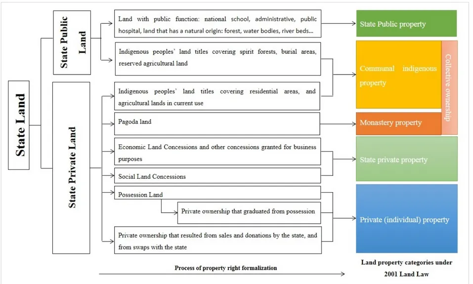
At the end of the 1980s collectivisation was officially abandoned. But on the ground, the land of Krom Samaki had already been distributed to peasants. Under the surveillance of the Bretton Woods organisations Cambodia then again engaged in an unprecedented set of reforms which radically changes the country’s land tenure institutions. Whereas the World Bank recommended starting with economic reforms including macro‐economic stabilisation through monetary and fiscal policies, price liberalisation and the privatisation of small and medium enterprises, Ljunggren (1993) shows that in fact Cambodia started with land reforms. In 1989, a number of new legal provisions relevant to land included amendments to the constitution (Jennar 1995). Land remained the property of the state and no‐one could claim rights to land acquired before 1979. All Cambodians now had the right to occupy, use and sell the land allocated to them by the state. Three types of land were defined: settlements (loumneuvthan), agricultural (kasekam) and concession (sampathian, covering more than 5 ha, for agro‐industrial development). At this stage, there was still a distinction between possession rights to agricultural and concession land, and ownership of residential land.
In order to synthesise all these new legal provisions, a Land Law was passed in 1992. This law confirmed that all land belonged to the state and that all Cambodians had possession rights (access, use, claim, transmission and exclusion). But the rest of the law was confusing. While it strictly forbade the private ownership of agricultural land, at the same time it established the conditions for someone with a possession certificate to become the actual owner of the land. Van Acker argues that this law failed to synthesise the three main land tenure regimes inherited from history: the acquisition `by the plough’, state, and private ownership promoted by the French and the socialist ideology which prevailed in the 1970s to 1980s (Van Acker 1999). In 1989, a procedure for so‐called ‘sporadic land registration’ was put in place to register the agricultural land. This sporadic process involved a number of steps before land titles could be issued, a procedure that So (2009) summarises into two main stages. First, farming families who had received land plots for cultivation were required to submit applications for land possession rights to the cadastral office. Importantly, the
application required verification by both the village and commune authority before being submitted to the district cadastral authority. Second, cadastral officials actually visited the plots to conduct technical surveys and demarcations, after which the application was forwarded for approval from different responsible authorities. This procedure, in two steps, resembles the one designed and implemented 70 years earlier under the French rule.
Again, the transition to private ownership remained incomplete. From the 4.2 million applications for land titles received by the cadastral administration, only 448,678 (10 percent) could be actually issued (Van Acker 1999). The complexity of the procedure and the clear lack of resources allocated by the state to endorse the implementation partially explains this backlog. But corruption associated with the procedure also excluded people from successfully completing the process. For example, if, officially, the registration of one plot cost USD 5, the real cost incurred by the applicant could reach as much as USD 300 to 400. At each and every step in the procedure an extra payment was required by the under‐ paid staff in charge of the registration. This real cost was obviously prohibitive for an ordinary peasant, who usually decided to abandon the procedure when asked to pay the extra. Those who could afford registration were the well‐connected people and the urban investors who became important actors in the land markets of the 1990s. The consequence of this procedure was, again, the dualisation of the land tenure regime between possession and property right, socially recognised and approved locally by Me Khum, and inalienable private ownership acquired through cadastral procedure. The distinction is very important as an ownership title can invalidate a possession certificate in the case of a conflict that goes to court (East‐West Management Institute 2003). And in the context of emerging land markets and rising land value this distinction is very significant.
Access to agricultural land in the 1990s is characterised by a rising inequality in terms of agricultural landholding size, taking place through the related processes of landlessness and land concentration.
Detailed and comprehensive data on the extent of landlessness and land concentration is not available, but estimates can be found from several surveys conducted in the 1990s: see Chan et al. (2001) for a synthesis. Each survey has its own sampling framework, so it is difficult to compare
them and to gather sense of the evolution of landlessness or land concentration. However, all surveys suggest that landlessness and land concentration increased in the 1990s (Sik 2000; Chan, Tep, and Acharya 2001).
The Landlessness and Development Investigation Tool survey (LADIT), conducted by the Oxfam Cambodian Land Study Project from 1999‐2000, presents the most convincing approach to examine and understand landlessness and land concentration. Based on recall survey methods, LADIT suggests that the proportion of people who were landless in 1960 was 4.01 percent, dropping to 2.48 percent in 1984 before rising sharply to 12 percent in 1999 and further to a predicted 15 percent in 2001 (Biddulph 2000). The survey states that landlessness was highest among families headed by single women—21.2 percent on aggregate. Among the landless, 54.8 percent had never owned land, while the rest had lost it for one reason or another. For those who never owned land the main reasons were reported as new marriage (42.3 percent), returnees (27.3 percent) and change of village (26.8 percent). Of those who had lost land, the main reasons for this were expenses due to illness (43.7 percent), lack of food (20.1 percent), expropriation (13 percent), indebtedness (4.6 percent), and natural disaster (3.4 percent). Other research on landlessness suggests similar results (Sik 2000; So et al. 2001; Diepart et al. 2006; Van Acker 1999).
Landlessness and land concentration are closely related to the emergence and rapid development of an active land market legitimised by the new economic reform agenda, namely economic liberalisation and privatisation. Land sales are usually driven by the socio‐economic vulnerability of the household (distress sales). On the demand side, land purchases are triggered by two types of actors: the successful farmers who accumulate capital in the agricultural and non‐agricultural sectors and buy additional land from their fellow peasants, and the emerging urban investors (Diepart 2011). In the absence of protective mechanisms that would prevent peasants from falling into over‐indebtedness, the land market of the 1990s led to market‐based dispossession and increasing landlessness in rural Cambodia.
The 1992 Land Law is sometimes portrayed as a ‘get rich quick’ manual for the upwardly mobile (Shaun 1999). But in most cases this law was not even applied. From 1993‐1998 more than one third of Cambodia land fell
outside the provisions of the 1992 Land Law, which was not explicit in respect of granting possible land concessions. In the prevailing post‐war socio‐economic context, the 1992 Land Law is highly problematic due to the convergence of several factors. The possibility to access land through markets and the increasing value of land, combined with the misuse of power, the incomplete and biased land titling services, and the absence of functioning land management institutions, set the stage for illicit land acquisition and the intensification of land conflicts. Anne Guillou shows that possibilities offered by the 1992 Land Law considerably increased land conflicts most notably on state land because the law did not offer a sufficiently strong juridical basis to resolve such disputes (Guillou 2006). As of 2002, George Cooper (2002) estimated that 200,000 poor Cambodians had fallen victim to on‐going, as‐yet‐unresolved, cases of large‐scale seizures.
Nature conservation efforts
In 1993, a royal decree for Protected Areas was issued to empower the Ministry of Environment to lead, manage and plan and develop a Protected Area system to preserve Cambodia’s land, forest, wildlife, wetlands and coastal zone (Royal Government of Cambodia 1993). Twenty‐three areas were included in the decree covering a total area of 3,289,000 ha (18 percent of Cambodia’s total national territory) including three RAMSAR sites (i.e. wetlands of international importance) signifying the global importance of Cambodian wetlands (Save Cambodia's Wildlife 2006). This decree distinguished four different types of protected natural areas: Natural Parks (areas of outstanding nature and scenic views to be protected for scientific, educational and entertainment purposes), Wildlife Reserves (natural areas to be preserved in their natural state in order to protect wildlife, vegetation and ecological balance), Protected Scenic View Areas (areas to be maintained as scenic views for pleasure and tourism) and Multi‐Purpose Areas (areas necessary for the stability of water, forestry, wildlife, and fisheries resources, for pleasure, and for the conservation of nature with a view to ensuring economic development). Likewise, a number of important fishing grounds were designated as protected fish sanctuaries (24,173 ha) (Map 2).