is an open access repository that collects the work of Arts et Métiers Institute of Technology researchers and makes it freely available over the web where possible.
This is an author-deposited version published in: https://sam.ensam.eu
Handle ID: .http://hdl.handle.net/10985/13806
To cite this version :
Willington SIABATO, Christophe CLARAMUNT, Sergio ILARRI - A Survey of Modelling Trends in Temporal GIS - ACM Computing Surveys - Vol. 51, n°2, p.30:1-30:41 - 2018
39
A Survey of Modelling Trends in Temporal GIS
1
WILLINGTON SIABATO,
Universidad Nacional de Colombia, Department of Geography; Universidad Politécnica de MadridCHRISTOPHE CLARAMUNT,
Naval Academy Research InstituteSERGIO ILARRI,
University of Zaragoza, I3A, Department of Computer Science and Systems EngineeringThe main achievements of spatio-temporal modelling in the field of Geographic Information Science that spans over the past three decades are surveyed. This article offers an overview of: (i) the origins and history of Temporal Geographic Information Systems (T-GIS); (ii) relevant spatio-temporal data models proposed; (iii) the evolution of spatio-temporal modelling trends; and (iv) an analysis of the future trends and developments in T-GIS. It also presents some current theories and concepts that have emerged from the research performed, as well as a summary of the current progress and the upcoming challenges and potential research directions for T-GIS. One relevant result of this survey is the proposed taxonomy of spatio-temporal modelling trends, which classifies 186 modelling proposals surveyed from more than 1450 articles.
CCS Concepts: • Information systems~Geographic information systems • Information systems~Temporal
data • Computing methodologies~Spatial and physical reasoning • Computing methodologies~Temporal reasoning
Additional Key Words and Phrases: spatio-temporal models; survey; literature review; temporal GIS; time geography; spatio-temporal databases; temporal models.
1. INTRODUCTION
While research on conventional databases started over 50 years ago (Charles Babbage Institute 1959, Codd 1970, Olle 1978), the focus on spatial databases as a specialized domain began with the groundwork of Berman and Stonebraker (1977) and Chang and Fu (1980), who defined the main principles of a spatial database architecture, suggesting for instance the Layered Architecture approach. During this process, the evaluation and adaptation of query languages for retrieving geometries (Frank 1982) and several proposals for indexing spatial data structures (e.g., Stonebraker et al. 1983, Guttman 1984) were also significant milestones. These works evolved into the Dual (Schilcher 1985, Ooi et al. 1989, Aref and Samet 1991) and Integrated architectures (Dayal et al. 1987). The latter represented a crucial instant in the development of spatial database architectures and resulted in several Spatial Database Management Systems (SDMS) such as PROBE (Orenstein 1986,
This work was supported by the Technical University of Madrid (Universidad Politécnica de Madrid), under grant ref.CH/056/2008, and partially supported by the UPM Training and Mobility of Researchers Programme (Resolutions 23/02/2011 – 28/06/2012). The authors wish to thank the Mercator Research Group for its dedicated support as well as the support of the projects TIN2016-78011-C4-3-R (AEI/FEDER, UE), TIN2013-46238-C4-4-R, and DGA-FSE. Willington Siabato was a research visitor at the Naval Academy Research Institute (IRENav), where he developed a large part of this survey. The authors thank all the anonymous reviewers and the editor for their valuable, detailed comments on the initial manuscript. We apologize to authors not included in this survey.
Author’s addresses: W. Siabato, Universidad Nacional de Colombia, Sede Bogotá, Department of Geography, Carrera 30 No. 45-03 Edificio 212 Ofc. 323, Bogotá D.C., P.C. 111321 – Colombia; Universidad Politécnica de Madrid, School of Topography, Geodesy and Cartography, wlsiabatov@unal.edu.co; C. Claramunt, Naval Academy Research Institute, Lanveóc-Poulmic, France, christophe.claramunt@ecole-navale.fr; S. Ilarri, University of Zaragoza, I3A, Department of Computer Science and Systems Engineering, silarri@unizar.es.
Permission to make digital or hard copies of part or all of this work for personal or classroom use is granted without fee provided that copies are not made or distributed for profit or commercial advantage and that copies bear this notice and the full citation on the first page. Copyrights for components of this work owned by others than ACM must be honored. To copy otherwise, distribute, republish, or post, requires prior specific permission and/or a fee. Request permissions from permissions@acm.org.
© 2017 ACM. 123-4567-24-567/08/06.$15.00 DOI: 10.1145/
**********
Orenstein and Manola 1988) and POSTGRES (Stonebraker and Rowe 1986). A comprehensive introduction and review of the state of the art of the evolution of spatial databases is available in Güting (1994); a previous overview of research issues in spatial databases was performed by Günther and Buchmann (1990).
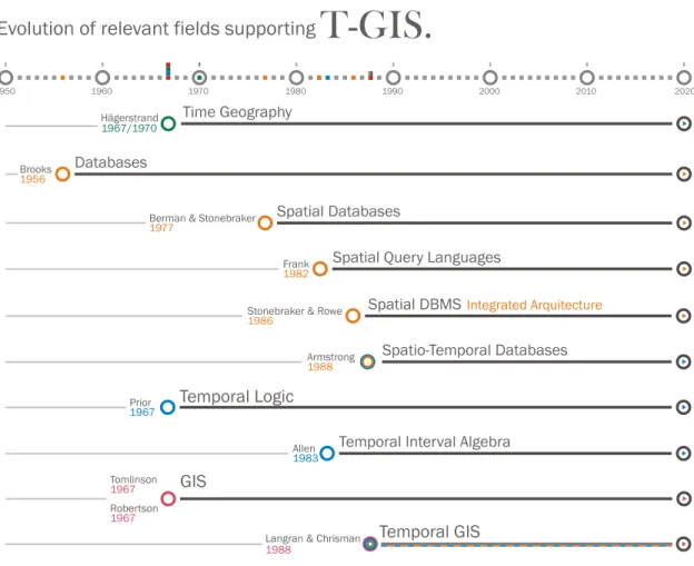
Formal studies of the temporal aspects of both non-spatial and spatial systems can be found since the early 1980s (Allen 1983, Clifford and Warren 1983, Ariav 1986, Rolland et al. 1987, Snodgrass 1987, Armstrong 1988) (see Figure 1). Nonetheless, time as a research subject has been specifically studied long before in other fields, such as natural language processing (Bull 1960), information systems (Langefors 1966), logic (Prior 1967, McArthur 1976), artificial intelligence (AI) (Allen 1983, Allen 1984), and Temporal Information Retrieval (Campos et al. 2015). Worboys (2005) indicates the existence of formal studies of time even since Hamilton (1837) concerning the algebraic theory conjugate functions. Despite initial academic attempts to include time in database systems (Brooks 1956), the earliest studies in which the time variable was considered for information processing, although not formally defined, were the ones proposed by Langefors and Sundgren (1975) and Wiederhold et al. (1975). An early review of the use of time in information processing systems is available in Bolour et al. (1982).
Figure 1. Milestones in the development of T-GIS
On the other hand, it is widely recognized that the first landmark project related to geographic information systems (GIS) is the early Canada Geographic Information System (Tomlinson 1967). Meanwhile, another important milestone in the development of GIS is a series of developments made at the Harvard Laboratory still
in the 1960s. This lab has been pioneer in the implementation of several GIS software packages such as SYMAP (Robertson 1967) and POLYVRT (see Peucker and Chrisman 1975) and in the design of geographical data structures and formats such as TIGER and DIME (Chrisman 1988). These spatial data structures played a significant role that enforced layered architectures in GIS databases and extended their impacts on temporal GIS development. A description of initial cartographic data structures is available in Peucker and Chrisman (1975).
The integration of time in GIS has been an important research subject since the late 1980s and still continues to be developed. In an early work, Donna J. Peuquet (1984) presented a taxonomy and an in-depth study of spatial data models and also mentioned the importance of time in spatial and geographic information systems. Regarding the integration of the time dimension, she concluded that “it is the one area currently identified in spatial data models and computer spatial data handling where we have barely scratched the surface.” (Peuquet 1984, p. 110). However, it was Langran and Chrisman (1988) who introduced, for the first time, some initial concepts for the temporal GIS (T-GIS) research field. If one considers that several proposals have been published during approximately the last 30 years (Langran 1988, Peuquet 1988, Delafontaine et al. 2011, Del Mondo et al. 2013, Ferreira et al. 2014, Zhu et al. 2017), this means that the GIS research field has considered the modelling and integration of temporal aspects about half the time of its lifespan and development. Figure 1 represents this fact.
How to represent time is a fundamental complex problem in temporal GIS. Three distinct types of time described originally by Snodgrass and Ahn (1985) became the de facto standard for defining time in temporal databases and information systems: valid-time (representing the time when an event occurs in the real world), transaction-time (representing the time when such event is recorded in a database), and user-time (for additional events registered by users). Most of the models described in this survey follow a linear, discrete, absolute temporal model, which must be assumed unless a different temporal model is explicitly stated.
Historically, the snapshot approach has often been the most common solution to manipulating and analysing spatio-temporal data in GIS, where temporal layers and spatio-temporal series are the data structures considered. Practically, the way geographic features change in space over time is not taken into account at the local level, and neither is the nature of the geographical processes that generate these changes; rather, changes are depicted at a global level not considering either related local factors or change of scale. This leads to several scientific questions such as those relating to the theoretical and modelling foundations upon which these components must be based. How can those modelling principles support successful implementations and convincing applications?
The goal of this article is to provide a broad historical overview of T-GIS, analysing the state of the art and identifying contributions from relevant related topics. Although it is grounded on the T-GIS research field, the intrinsic nature of data and processes in that field is complexity, a characteristic that has an impact on diverse disciplines. Therefore, this survey shows how other fields have contributed in various ways, addressed such characteristic from different perspectives, and are currently defining a new path determining the latest trends in temporal and spatio-temporal aspects in GIScience (geographic information science); among those influencing fields, the areas of artificial intelligence and temporal logic can be particularly highlighted. We identify the actual and respective achievements of those different disciplines in the field of T-GIS, and how together they have made a coherent contribution. We also describe significant milestones and landmarks that have made T-GIS an independent research subject. Chiefly, we present a description of relevant spatio-temporal models proposed over the past three decades. The article is also intended to identify the dominant modelling trends and discuss the next research challenges in T-GIS.
1.1 Literature Covered in this Survey
This survey mainly covers research on T-GIS performed during the last three decades. The surveyed literature is classified considering the scientific disciplines described in Appendix A.1 (see Figure A) and the following criteria:
The different areas that have made some valuable contributions to T-GIS and including them in the four main disciplines identified.
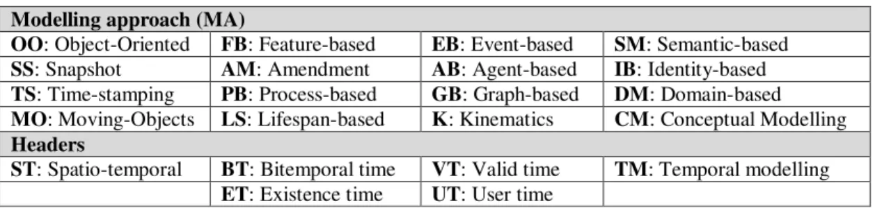
Considering the theoretical models on which each proposal is based, i.e., location-based, semantic-based, feature-based, event-based, process-based, identity-based, object-oriented, ontology-driven, graph-based, lifespan-based, agent-based and based on moving objects.
The selected approaches discussed in this article are amongst the most representative because they show key developments for spatio-temporal modelling, and temporal modelling and reasoning. In addition, the approaches described reflect in a way the evolution of this research subject starting from its early-1960s foundations to today's conceptual modelling formalisms across the multidisciplinary areas that have made relevant contributions.
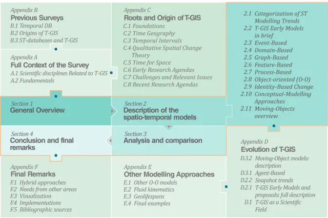
To make this survey reasonably self-contained and comprehensive, we have included early and modern perspectives to illustrate the evolution of T-GIS. This article and the online appendix offer an extended description of the topics surveyed and a large number of references. As a result, one could read this review from three different perspectives: (i) origins and historical evolution of T-GIS; (ii) development of the spatio-temporal models; and (iii) future trends and developments in T-GIS. Although these views are well-aligned and complement each other, making a single body article, they also provide a detailed description of each topic by themselves. Figure 2 represents a conceptual map that serves as the thread of the survey. Appendix F.5 describes the bibliographic sources on which this survey is based.
Figure 2. Conceptual map of the survey. Connection of the concepts described in the article and the online appendix
In the remainder of this article, Section 2 provides a detailed analysis of the different spatio-temporal models. Section 3 compares the surveyed modelling approaches and provides a classification for the identified spatio-temporal modelling trends. Finally, Section 4 collects conclusions and future research trends. Besides, several
electronic appendices, that provide relevant complementary information and detailed descriptions of other modelling approaches, complete the survey.
2. SPATIO-TEMPORAL MODELS
This section outlines the fundamental aspects of several spatio-temporal data models proposed during the late 1980s, the 1990s, and the 2000s, as well as some of the latest approaches that have arisen during the current decade. Some of them are theoretical models; others are grounded upon specific case studies that have dealt with the evolution of spatial objects over time applied to specific scenarios, such as land use evolution, wildfire growth, or road network reconfiguration. First, a classification of spatio-temporal modelling trends is presented in Section 2.1, and then a set of representative spatio-temporal modelling proposals are described in the subsequent subsections. This section is complemented by Appendix D and Appendix E, which include a description of other relevant spatio-temporal proposals and provide additional details of the ones discussed.
In addition, Appendix A and Appendix B describe in detail the context and characteristics of this survey. They present (i) a review of the scientific disciplines related to T-GIS; (ii) a complementary overview of the literature covered herein; (iii) fundamental ideas that support the concept of T-GIS; and (iv) related works. 2.1 Categorization of Spatio-temporal Modelling Trends
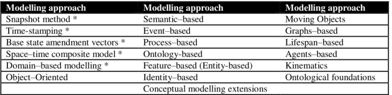
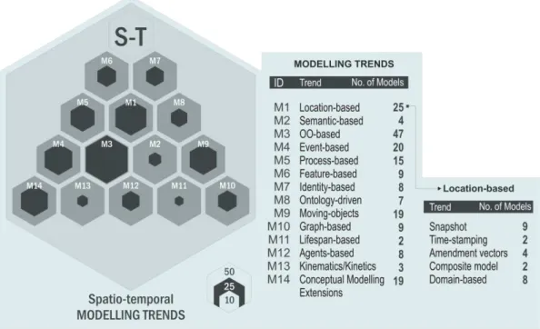
Over the past years several spatio-temporal models have been proposed (see Peuquet 2001, Pelekis et al. 2004). They can be classified by considering their theoretical approach; Table 1 presents different modelling methodologies that have arisen in the last three decades. These approaches are intended to describe the dynamic nature of geographic phenomena through five dimensions: events, processes, movement, actions, and dynamic objects. According to Yuan (1994), the snapshot method, time-stamping, the approach by using base state amendment vectors, the space-time composite model, and the domain-based models could be generalized and classified as location-based models, also called by other authors version-based approaches (e.g., Halls et al. 1999) or changed-based approaches (e.g., Yuan and Stewart Hornsby 2008). Table E, in Appendix D.1, lists most of the spatio-temporal models developed for each modelling approach.
Table 1. Classification of spatio-temporal modelling trends by the key conceptual element
Modelling approach Modelling approach Modelling approach
Snapshot method * Semantic–based Moving Objects
Time-stamping * Event–based Graphs–based
Base state amendment vectors * Process–based Lifespan–based Space–time composite model * Ontology-based Agents–based Domain–based modelling * Feature–based (Entity-based) Kinematics
Object–Oriented Identity–based Ontological foundations Conceptual modelling extensions
* location-based models / changed-based approaches A full version of this table is available in Appendix D.1, Table E Different classifications have been proposed for spatio-temporal models. Yuan and Stewart Hornsby (2008) advocate distinguishing approaches based on the origin of change and propose six classes: time-stamped; event-based; changed-event-based; process-event-based; movement-event-based; and activity-based. Another alternative differentiates between the object–based and the field–based modelling approaches, classifying the proposals according to their underlying (i) raster (e.g., Peuquet and Duan 1995, Sengupta and Yan 2004) and (ii) vector (e.g., Claramunt and Thériault 1996, Choi et al. 2008) data structures; considering (iii) hybrid approaches (e.g., Tryfona and Jensen 1999, Galton 2004, McIntosh and Yuan 2005b, Liu et al. 2008); or being (iv) generic enough to support both
raster and vector data structures (e.g., Armstrong 1988). The SNAP/SPAN ontology introduced by Grenon and Smith (2004) offers a solid conceptual foundation that emphasizes the existing dichotomy between objects and fields, as well as the concepts of snapshot, change, and process. Worboys (2005) presented a “brief history of time”, which represents a summary of the evolution of time in GIS. He describes four main phases in the development of spatio-temporal information systems: “static GIS, temporal snapshots, object change, and events and actions”. Nowadays, it would be necessary to add a fifth stage: intelligent agent systems (see Appendix D.3.1 for further description). El-Geresy et al. (2002) propose five categories by considering conceptual modelling aspects: (i) location-based, (ii) object or feature-based, (iii) event-based, (iv) functional or behavioural, and (v) causal approaches. Bothwell and Yuan (2011, p. 153) claim that “six descriptors are needed to adequately describe object spatio-temporal dynamics”: location, extent, attribute, movement, mutation, and evolution. Nonetheless, for the purposes of this survey the classification proposed in Table 1 is followed; highlighting the most relevant contributions and presenting a chronological evolution of both the modelling approaches and trends. Since some proposals are related to different modelling approaches, they have been classified in the dominant approach; Table 8 in Section 3, however, shows the various approaches to which each model is related.
2.2 T-GIS Early Models and Proposals
During the 1980s, in a domain closely related to T-GIS, several early proposals were made in order to incorporate temporal data in relational databases, e.g., time-stamping tables (Gadia and Vaishnav 1985, Gadia 1988), time-stamping tuples (Snodgrass and Ahn 1985, Snodgrass and Ahn 1986), and time-stamping cells (Gadia and Yeung 1988). These database models clearly influenced the development of early T-GIS proposals. Tables were replicated as time-stamped layers, e.g., the snapshot model (Armstrong 1988); tuples (rows) as time-stamped attributes (columns), e.g., the space-time composite model (Langran and Chrisman 1988); and cells as spatio-temporal objects, e.g., the spatio-temporal object model (Worboys 1994a).
A complete description of these early models, as well as other foundational proposals, is available in Appendix D. The snapshot method, the base state amendment vectors approach, the space-time composite model, the time-stamping ST method, the triad framework, as well as other trends regarding the snapshot approach are described in Appendices D.1 and D.2.
2.3 Domain-Based Models
Yuan’s Three-Domain Model (TDM) (Yuan 1994, 1997, 1999) represents spatial, temporal, and semantic objects, and provides references amongst them to describe geographic processes and phenomena. This three-domain representation, developed in the context of wildfire studies, is defined as a normalization of three previous modelling proposals: the space-time composite model; the snapshot model; and the initial stages of the spatio-temporal object model (time-stamped ST Objects, Worboys 1992a,b). In this sense, this proposal inherits part of the characteristics and strengths of the location-based models (see Section 2.2). As the author states, “the three-domain representation is a normalization” of the location-based models because it “eliminates repetitive data records in spatial attribute tables … by only using a single attribute record for separated locations with common properties.” (Yuan 1999, p. 148). Nevertheless, it goes one step further regarding the utility that spatio-temporal systems can bring to users through GIS in considering queries about attributes, locations, spatial features and relationships, as well as time and temporal features and relationships.
Yuan identifies a set of the minimum spatio-temporal queries that any spatio-temporal system should answer: simple and range queries. While simple queries consider instants, range queries consider periods. The three-domain model is proposed as a modelling approach to answering such queries; it focuses on the functionality of the model in actual systems through the implementation of the three-domain framework.
The improvement of this model is its capacity to manage change in the three modelling components. This characteristic represents a significant enhancement over existing models that manage either the time or the location. It considers the time as a temporal object rather than an attribute. Semantic changes “include variations
in attributes over time and the static spatial distribution of a geographic phenomenon.” (Pelekis et al. 2004, p. 246). Spatial variations may be static (looking at changes in a snapshot) or transitional (comparing “states of an event or a process at different [locations] through entity snapshots.” (Yuan 1996, p. 27). Changes are either the movement of an entity or mutations of an entity that is spatially fixed. Time is modelled as an independent domain instead of being a location’s attribute, unlike the snapshot model (see Appendix D.2.1), or a part of spatial entities, like in the case of the space-time composites and spatio-temporal objects (Yuan 1996). The model supports valid–time and transaction–time, and time can be represented in both absolute and relative terms. Besides, it is able to represent the six types of spatio-temporal changes and analysis defined by Yuan (1997); for further details see Table D in Appendix B.3. The dynamic nature of the three-domain framework is a remarkable difference of this proposal and its supporting models.
2.4 Event-Based Modelling
While time-stamping approaches focus on the idea of change to enhance spatial data with temporal components, event-oriented approaches “focus on the dynamic happening as a whole, and not just the time of the event.” (Yuan and Stewart Hornsby 2008, p. 38). When there is a change, a time-stamp marks the time of the change; the event-based approach, however, allows the distinction of event attributes and relations besides object attributes and relations (Yuan and Stewart Hornsby 2008). This section presents some of the most representative event–based modelling approaches.
Several academic discussions exist about the definitions of processes and events and their differences. It is not clear where the former finish and the latter begin. There is no single or exclusive relationship between them; depending on the phenomena modelled their nature changes. Galton and Worboys (2005), Yuan and Stewart Hornsby (2008), Yuan (2001), Claramunt and Thériault (1995) and Yuan (2008) have provided valuable discussion as to these conceptual elements. Some definitions seem to be contradictory. According to Galton and Worboys (2005, p. 48), there is a general consensus that the “key concepts required for the modelling of dynamic phenomena include object, state, process and event”, but how these should be defined is not so clear:
Galton and Worboys (2005) state that while objects and processes can experience change and such changes can be described as multiple states, an event does not experience change. An event is by definition an episode of history finished, that does not experience changes after being; the event appears in time and can subsequently appear in another point in time as a subsequent event, but different from the previous one. Yuan and Stewart Hornsby (2008) offer a conceptualization quite aligned with Galton’s (see Table A in
Appendix A.2). In contrast, Yuan (2001) asserts that an event is a spatio-temporal aggregate of its corresponding processes, and a process is a sequential change of states in space and time. While events operate at the coarsest spatial and temporal resolution, states have the finest resolutions.
Despite the differences in meaning, both Yuan and Galton agree that a process involves different states. Claramunt and Thériault (1995) also consider a process as the aggregation of changes that are related or produced simultaneously; they state that processes can be defined naturally through changes and events. An event can be represented as a set of processes that modify entities. In addition, they consider as a key element the definition of the temporal scale; the chronon is the minimum unit for establishing such scale. Since an event can be seen as a process depending on the granularity of modelling, it is not possible to define a hard boundary between such concepts. As Worboys (2005, p. 3) states, “one person’s process is another’s event, and vice versa”. This discussion can be even deeper when considering more general concepts such as continuants and occurrents. Ultimately, as Yuan (2008, p. 178) asserts, “events and processes are central to the understanding of geographic worlds. They constitute information of interest to many, and perhaps, the majority of applications and scientific inquiries”. Despite the blurred definitions, a large number of spatio-temporal models considering events and processes have been proposed.
Time-based analysis of spatio-temporal data. Peuquet and Wentz (1994) proposed an initial approach for a time-based analysis of spatio-temporal data. The model was defined as a complement to the object-based and location-based analysis approaches because of their natural restrictions to temporal representations and temporal
querying capabilities. Starting from an initial state, called the base map, events are recorded in increasing order of their occurrence, with each event linked to a list of changes experienced since the event vector was last updated. To avoid data redundancy, the changes can be recorded based on the differences from previous versions. If changes are extensive to the whole mapped area, “the full map may be registered.” (Pelekis et al. 2004, p. 244). This proposal was validated by a prototype, TEMPEST (Edsall and Peuquet 1997), that incorporated the time-based data model and the corresponding relational operators.
TEMPEST implemented the triad conceptualization (see Appendix D.2.1): where (location-based), when (time-based), and what (object-based), and provided the first temporal analytical capabilities in a GIS software. This prototype also demonstrated the feasibility of the triad framework. In contrast to the amendment vector approach (see Appendix D.2.1), which also stores a base map and considers incremental object changes but restricts searching to location, TEMPEST was defined around a timeline instead of a location, which increased the performance of temporal data queries, considering not only where but also when change occurs.
Event Oriented Spatio-Temporal Data Model (ESTDM). In a follow-up work, Peuquet and Duan (1995) introduced the ESTDM, a raster-based event-oriented proposal that has shown its efficiency in supporting spatial and temporal queries. It represents information about changes at pre-defined cells. It stores changes regarding an initial state (represented by a base map) rather than a snapshot of an instance. Basically, (i) a base map represents the initial condition; (ii) “it groups time-stamped layers to show observations of a single event in a temporal sequence” (Pelekis et al. 2004, p. 244); (iii) a header file stores the temporal sequence of events when there are changes; and (iv) a set of components encodes the locations where changes occur and the attribute values at the time of the event. The authors define an ESTseries (i.e., an Event-based SpatioTemporal series) as a “single ESTDM-formatted file that represents the spatio-temporal dynamics of a single thematic domain for a specific geographic area, equivalent to a single thematic map layer.” (Peuquet and Duan 1995, p. 15).
According to the authors, the most significant capabilities of ESTDM in GIS are the possibility to perform temporal data manipulations (e.g., temporal scale change) and sequential time-based comparisons. However, the ESTDM does not maintain the object’s identity beyond the initial location, and therefore it cannot “represent its discrete object properties, such as moving, splitting, merging, and incarnation.” (Yuan 2001, p. 85). This results in an obvious behaviour, since the model is focused on fields rather than objects: the evolution is focused on continuous, extended, general areas rather than specific objects and their properties.
Hybrid Spatio-Temporal Data Model and Structure (HST-DMS). The HST-DMS (Sengupta and Yan 2004) presented a significant improvement on the ESTDM regarding searching efficiency and data storage in very large databases. Querying improvements are based on the storage of based maps, change maps and complement maps at the time of each event. The base map “only stores those elements that never change through the entire time period represented by the event list.” (Sengupta and Yan 2004, p. 357). The “change map for an event” only stores changes since the previous event, which is similar to the sequence of events managed in ESTDM. On the other hand, the complement map stores additional changes from the change map instant to a “past time step”. The base, change, and the complement maps are associated with equal starting instants.
HST-DMS solves the problem of object identity (a single identity disappears across changes avoiding change tracking), and it can build a snapshot for a given time period ti without the need to visit all the time nodes
starting from the base map. The authors report that the “data model requires significant processing when a new time step is added to existing information. To creating a new change map and complement map for the added time step, a new base map and starting complement map will also have to be created.” (p. 357). This limitation can be omitted if one considers the processing capabilities available nowadays. Both ESTDM and HST-DMS manage implicit spatial and explicit temporal topology. The models have proved to be efficient in raster data scenarios; however, they are limited to valid–time.
Event-oriented approach based on extended-versioning. Claramunt and Thériault (1995) proposed an event-oriented approach for the management of time in GIS which relies on two complementary phases: (i) defining a suitable conceptual model by identifying the temporal processes and the related spatio-temporal operators; and (ii) designing the corresponding logical architecture. The proposed model is based on an extension of the versioning concept, the extended-versioning, defined as “a mechanism for recording the history
of the database and for describing successive events in the real world.” (Claramunt and Thériault 1995, p. 24). Considering that processes can be naturally defined through changes and events, the authors based their approach on the modelling of processes and the changes involved. According to their nature, processes are divided into three categories: basic (appearance, disappearance, spatial stability), transformation (expansion, contraction, deformation), and movement (displacement, rotation). As usual, geographic phenomena are represented by the three main domains (thematic, spatial, and temporal), each of them recorded in an independent table (the attribute, the version, and the spatial tables, respectively) every time a change occurs. Changes are recorded in three versioning tables, i.e., past, present, and future. Each table is related to both the attributes and the spatial component. When there is a spatial or thematic change, a new version is added to the versioning tables; thus, the evolution of entities is recorded for attributes and geometries at any time.
This model was “the first successful attempt to record the individual descriptive characteristics of dynamic objects.” (Pelekis et al. 2004, p. 248). The incorporation of indexes based on binary trees, such as the B+Tree value-oriented index (Comer 1979) for the current version table and a multi-dimensional R-Tree (Guttman 1984) for previous and future tables, improves the performance when querying and retrieving the different states of each element.
Temporal logic-based approach. From a temporal logic perspective, Eric Allen et al. (1995) presented a generic model to represent causal links related to events in a spatio-temporal GIS, a qualitative causal modelling in T-GIS. The causal theory compounds elements and relations that are presented via a conceptual data model using an extended entity-relation formalism based on MODUL-R (Caron et al. 1993). These elements include four entities (i.e., objects, events, agents, and conditions) and three relations (i.e., produces, is part of, and conditions). Both objects and events may have spatial representations, and all entities may have temporal representations. Based on Bunge’s (1966) theory of causality and Kowalski and Sergot's (1986) event calculus, the authors propose a model that explicitly deals with spatial and temporal phenomena; they state that “no existing temporal logic yet deals adequately with spatial relations.” (Allen et al. 1995, p. 410). In general, the authors adapted Bunge's theory to a theory of events. This model emphasizes that the data structure must be accessible for efficient analysis. As Peuquet (2002) suggests, the authors also consider that causal relations must be explicitly represented within the database if one needs to retrieve them for analysis. The explicit representation of events in the database is not difficult since they can be treated as any other object.
The resulting model provides tools for analysing historical scenarios and for understanding the current status of a region as a function of causal dependencies in the past. However, there is some ambiguity in the treatment of causality and dependence. In addition, the issue of obtaining or inferring causal connections between events is not addressed.
Pure event-oriented theory of space and time. Defined as a step forward from the object-oriented concepts developed in Worboys et al. (1990b) and Worboys (1994b), Worboys (2005) presents a new event-based model to describe geographic phenomena. He developed what he defines as a “pure event-oriented theory of space and time”. He asserts that it is necessary to model world observations not just as singular data collections but also as complex entities containing identity, internal structure and behaviour, and with capabilities to relate them to other entities and integrating in the environment in which they are included. He also states that a fully event-oriented framework should allow one “to move on from simple snapshot queries of the form ‘What happened at this location at this time?’ to a much richer language involving the interplay between object and events, and event–event relationships.” (Worboys 2005, p. 9). Thus, he argues that a breakthrough in the computer modelling of geographic phenomena will arise thanks to switching from an object-oriented view of the world to an event-oriented perspective. Defining a four-stage classification in the progression of spatio-temporal information systems (Static GIS, Temporal snapshots, and Events and actions) in which the author describes the basic elements, advantages, and problems of each approach, he concludes how “the final stage in this evolution is a full-blooded treatment of change, in terms of events and actions.” (p. 7). Worboys considers a division of world entities into continuants, “that endure through time” (e.g., houses and people), and occurrents, “that happen or occur and are then gone” (e.g., dinners and house repair jobs). His approach is, therefore, classified into the SPAN modelling ontology (see Grenon and Smith 2004).
For the formalization of the model, Worboys considers temporal structures of precedent works (tense and temporal logics, situation calculus, event calculus, interval temporal logic) and shows why the use of algebraic theories produces better results than logic-based approaches to defining a formal model of concurrent occurrences. Concurrency and interaction are the basic operations with which this model describes dynamic complex processes. Several processes are concurrent if they occur in the same time period. Two processes interact if their input and output actions (complementary pair) can be matched. The tick atom describes the temporal component, defining time as a sequence of ticks. The location describes the spatial component as “a connected region, partitioned into a set of blocks.” (p. 18). The final component is a spatio-temporal entity (entity) through which the dynamic nature of the world is represented by using structured collections of ST-entities.
The advantages of the model and its formalization are described in a case study representing the movement of a vehicle along a route that goes through a specific spatial region. Three temporal states (ticks) and five locations are considered, modelled as Clock3 and Region5, respectively. The movement system is defined as Motion = Vehicle|Clock3|Region5. The solution of the system demonstrates how the basic elements are applied and illustrates the spatio-temporal dynamics of the analysed phenomenon, e.g., the interactions of the vehicle at different instants (ticks) in some position in space (location).
This work is undoubtedly an evolution in the taxonomy of spatio-temporal models. The proposal shows how spatio-temporally extended process calculi is a powerful tool to represent the dynamics of geographic phenomena. The fact that the model is based on general mathematical theories and constructs guarantees the developed concepts as being general and computationally implementable. However, as the author asserts, this theory “needs to be scaled up to work with full-scale occurrents [processes] in the world.” (Worboys 2005, p. 26). The model considers a discrete viewpoint of reality, so continuous representations are beyond its scope. The proposal also lacks the possibility of multiple temporal granularities for describing phenomena. A significant advantage of this proposal is that geographic happenings (occurrents) and interactions are modelled considering their significance, i.e., by explicitly considering their semantics.
Geospatial Event Model (GEM). In a follow-up work, based on the conclusions of Worboys (2005), Worboys and Hornsby (2004) proposed the Geospatial Event Model (GEM). Since objects and events are “needed to model fully a dynamic system” (p. 328), the authors adopt a hybrid approach considering “three basic entity types: geospatial object, geospatial event, and geospatial setting (geo-settings).” (p. 339). A geo-setting is defined as “the distinguishing characteristic of a geospatial entity” (p. 328), and therefore one could have geo-settings for both objects and events. It could be purely spatial, purely temporal (instant, interval, or period — defined as a composition of intervals—), or mixed spatio-temporal (trajectories, histories, or geospatial lifelines). The mixed spatio-temporal setting is considered as a function from the temporal to spatial settings. A unique characteristic of the model is that it does not allow combinations of the three kinds of settings in relationships; for instance, a spatial setting cannot be mixed with a temporal setting.
In essence, the model is described as follows: (i) the events are modelled “as instances or classes”; (ii) events (like objects) can have “attributes describing their properties”; (iii) “classes of both objects and events may be arranged in a hierarchy” (p. 333); and (iv) objects and events can be “aggregated into composite entities, and decomposed into parts”, i.e., spatial parts in the case of objects, and temporal or spatio-temporal parts in the case of events. Regarding the existing relations, situation corresponds to the geographic location of events and objects. “The static geospatial object model is timeless and the settings in which geospatial events are situated are spatio-temporal.” (Worboys and Hornsby 2004, p. 333).
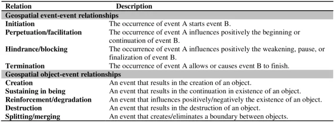
The model considers four event-event and five object-event relationships (see Table 2). The latter represent the mutual dependency of objects and events: objects need an event occurrence to exist, and objects provide meaning to events. The participation and involvement relationships represent that objects take part in events and events imply objects (Grenon and Smith 2004).
The authors also consider an extension of the Unified Modelling Language (UML) (Booch et al. 1999) class diagram to make a distinction amongst different types of classes, particularly between the object class and the event class. The GEM provides a general approach to modelling dynamic geospatial domains by considering
changes in objects, the events that produced such changes, and the definition of possible dependency relationships between them.
Table 2. Event-event and object-event relationships defined by Worboys and Hornsby (2004)
Relation Description
Geospatial event-event relationships
Initiation The occurrence of event A starts event B.
Perpetuation/facilitation The occurrence of event A influences positively the beginning or
continuation of event B.
Hindrance/blocking The occurrence of event A influences positively the weakening, pause, or
finalization of event B.
Termination The occurrence of event A allows or causes event B to finish.
Geospatial object-event relationships
Creation An event that results in the creation of an object.
Sustaining in being An event that results in the continuation in existence of an object.
Reinforcement/degradation An event that influences positively/negatively the existence of an object.
Destruction An event that results in the destruction of an object.
Splitting/merging An event that creates/eliminates a boundary between objects.
Although an extension to UML (Booch et al. 1999) is proposed, it does not go far beyond a diagram specification and it does not consider strong concepts such as the ones presented in the extensions of conceptual-modelling approaches (see Section 2.10). The proposal considers a basic, theoretical case study which shows how to apply the modelling concepts; however, it is not possible to evaluate its feasibility, since no implementations are reported. In spite of this, the example shows how the GEM adds, as a new characteristic, further clarification of the object-event relationships.
Event-based query framework. Supported upon the dynamic time warping (DTW) similarity method, McIntosh and Yuan (2005a,b) introduced an event-based query framework, along with a set of six indices (change indicators, such as elongation, growth, etc.) of static and dynamic measures that quantify the characterization and similarity of geographic events (see Table 3). As discussed above, the comparison of snapshot pairs considers only changes between two time instants rather than the life cycle of an event; this proposal applies a method to identify such a life cycle. Since the DTW method measures the similarity between sequences which could vary in time or speed, varying events of all natures can be analysed. This proposal presents a novel method that measures changes in fields using objects as an intermediary stage, i.e., areas of interest from fields (continuous areas) are converted into objects in order to apply the six proposed indices and show how events evolve and interact.
Table 3. Indices proposed by McIntosh and Yuan (2005a,b) to characterize objects and relationships
Static Indices
For objects Elongation … of the best ellipsoidal approximation of the object.
Orientation … of the major axis relative to the movement direction.
For object relationships Distribution … of objects considering a measure of clustering.
Dynamic Indices
For objects Growth Percentage of growing.
Granularity Scale of change in the conceptual object’s surface.
For object relationships Relative
While some spatial models, namely the ESTDM, are able to track changes in individual cells, events represented in raster data are usually related to more than one cell. The authors indicate that with GIS technology it is not possible to associate and summarize cells that jointly correspond to changes caused by a geographic event. They propose, as a possible solution, to identify interesting cells as features and to represent those features explicitly as data objects. In brief, the proposal comprises four steps: (i) to extract features as the footprints of a geographic event; (ii) to store the features as vector objects (each consisting of a field that encodes the spatial change captured by raster data); (iii) to link these vector objects temporally using a linear model; and (iv) to reference the vector objects back to the corresponding cells in the original images.
The same feature can be drawn on multiple and sequential snapshots resulting in a collection of objects that represents how the geographic entity evolves in space and time. Querying the resulting change patterns is achieved “by comparing the temporal sequence of features by characterizing vector objects and their embedded fields.” (McIntosh and Yuan 2005b, p. 226). The six indices quantify the characteristics of objects and fields. The measurement of similarity is based on three assumptions: (i) meaningful features identified from raster data in a temporal sequence (i.e., the identification of conceptual objects) represents the development of geographic entities; (ii) the behaviour of conceptual objects describes the progression of a geographic event; and (iii) temporal sequences of indices that measure the behaviour of conceptual objects can quantify the evolution of an event.
The static indices portray the current state of the object and its relationships, in addition to providing a baseline for the dynamic descriptions. In turn, a temporal sequence of static indices provides historic data representing the changes produced in space and time. In essence, according to the authors, “… the shorter the distance between two events in the measurement space of the indices, the higher the degree of similarity.” (p. 227).
Although the DTW algorithm is computationally intensive, the contemporary processing capabilities make it viable when computing large sequences to measure and identify changes. However, a significant limitation of this proposal is the indeterminacy of the delimitation of a phenomenon’s boundary when extracting the objects from the field; there is uncertainty in the real boundary of the phenomenon and slight changes in incompatibility for the attributes as for the pixels defining the borders of the fields (raster values intersected by an object). This uncertainty also impacts on the topological relationships amongst different delimited features; such relations will change according to the way in which the boundaries have been delimited. The Geo-atom model (Goodchild et al. 2007), further described in Section 2.7, could act as a complementary model to this proposal since the geo-objects (aggregations of geo-atoms according to rules defined in the values) could be an alternative to the aggregation concept. Moreover, the integration of the two models would support the management of both events and processes simultaneously.
Continuous spatial change in an event-oriented discrete spatio-temporal framework. Worboys and Duckham (2006) tackled the problem of modelling continuous spatial change in an event-oriented discrete spatio-temporal framework. The authors show how the proposed framework can be used to detect conventional spatial events (e.g., merging, splitting, stasis, movement, and hole formation and disappearance). The proposal is based on a triangulation of the analysed surface. Combinatorial maps and triangulations are the key elements for analysing spatial structures evolving in a two-dimensional Euclidean space. The evolution is based on the principle that triangulations can evolve through time, modelling space like a spatio-temporal scalar field function (f : T(SD)), i.e., for each time instant T, there is a spatial change S of values from D (the value domain). Continuity and incremental change determine the evolution of the triangulated network over which geographic phenomena changes are represented.
A couple of properties guarantee the continuity of the surface. Firstly, in strong connectedness, there is a path between two vertices in such a way that every point in the path, except maybe the beginning and end points, can be surrounded by or enclosed within an open set entirely contained within a defined region R. Secondly, with weak connectedness, on the other hand, this condition is not satisfied. Computationally, to determine whether or not a triangulated region R is connected, the underlying graphs contained in R must be considered; for instance, by applying a standard breadth-first search.
The way in which the network continuously evolves constrains the representation of the event at a specific instant, i.e., the representation of the evolving event depends on the incremental evolution of the triangulated network. To control the evolution of the network, a collection of transition rules and conceptual neighbourhood definitions are considered. The transition rules are combinations of (constraining or not) insertions and deletions to occur at the boundary (subject to preserving or not regularity). The neighbourhood definitions depend on the established rules; they determine the adjacency relations between the evolving triangles of the network. The application of the transition rules and the neighbourhood definitions determines the changes (e.g., movement, contraction, expansion, or splitting) of an event.
Worboys and Duckham (2006) offer a computational model of spatio-temporal data that supports the representation and querying of events in regions. The authors suggest that the model has particular relevance in scenarios in which data are derived from sensor networks, for instance in environmental monitoring. A significant advantage of this proposal is that it offers a comprehensive modelling option for analysing and modelling the continuous change of geographic phenomena. Since the delimitation of the boundary of the modelled phenomenon depends on the density of the triangulated network, it would be necessary to adopt a fine-grained network in order to reduce significantly the spatial imprecision and the corresponding edge effects. While the proposed model assumes a triangulation of the surface to control the evolution of the events, it could be generalized in order to support, as a spatial framework, any planar tessellation.
2.5 Graph-Based Modelling
While the graph-based modelling approach seems to have been put aside during the 2000s, the current decade shows an active interest in this approach. The simplicity of defining relationships amongst geographic entities and the representation of their evolution results in significant flexibility for the representation of changes, movement, and events, which in turn allows the integration of graphs with other modelling trends. For instance, it might be possible to complement the graph-based approach to model events and processes by following the principles that rule Petri nets (Murata 1989). Graph-based modelling approaches proposed during the last years are the following.
History Graph Model. Although Yuan’s three-domain model uses a graph to represent the transitions amongst spatial objects at different locations, the first graph-based modelling approach, called the History Graph Model, was actually proposed by Renolen (1996). Its main purpose is to identify the different sorts of temporal behaviours and to handle objects and events. The model is intended to visualize the temporal element in order to reproduce the evolution of geographic information. The basic idea is that an object may be in a changing state, static state, or dead state. Each version of an object is identified by two timestamps that describe the time interval during which the state of the object is valid (i.e., alive). A transition is an entity that links versions of objects with their successors and/or predecessors. Two additional timestamps describe the period when the transition has taken place. Events are transitions of no duration, that characterize objects that change suddenly, while snapshots are versions with no duration, that represent intermediate states of objects that change continuously. The objects of a dataset can be characterized by a sequence of states and changes (Pelekis et al. 2004).
For representing the evolution of the objects, the model’s notation is based on Petri nets (Murata 1989). The object versions (static states) are represented with square boxes, whereas the transitions between versions (changing states) are denoted by boxes with rounded ends. Sudden changes are represented as circles. Both states and changes are linked to a time interval; the boxes are extended to represent the corresponding time interval (Renolen 2000). A dead object is denoted by a dashed square box. The arrows between states show successor-predecessor relationships between the origin and target state. Seven types of changes are considered: creation; reincarnation; destruction; alteration; merging/annexation; splitting/deduction; and re-allocation. A typology of processes was introduced earlier by Claramunt and Thériault (1996).
According to Pelekis et al. (2004, p. 249), “the primary application of a history graph is to describe a limited extent in time and space”. The authors also state that its advantage is that “temporal relationships can be derived directly and that time can be modelled both as discrete or continuous as well as absolute or relative”
and that it captures “all the knowledge we need in order to further develop a spatio-temporal system”. Furthermore, it captures the concepts of both movement and change and supports most spatio-temporal query types. The model expresses events such as “splitting and merging”, and can be extended to better characterize the duration of events. A restriction is that history graphs poorly describe the interaction between objects, e.g., split/deduction processes usually imply the creation of an additional object and the modification of another. In addition, there is not a defined method to determining all the processes and/or mutations: events are referenced to a given timeline and can only be queried one at a time.
Spatio-temporal graph-based model for two-dimensional regions. The graph-modelling approach has been reconsidered recently, as Del Mondo et al. (2013) have presented a discrete, spatio-temporal graph-based model oriented to the modelling of evolving two-dimensional regions. The authors introduce a formal approach for analysing “the consistency of relationships of evolving entities” through a spatio-temporal graph. This proposal is an extension of previous research (Del Mondo et al. 2010) in which the authors modelled the temporal interaction networks derived from the evolution of entities considering spatial relations, spatio-temporal relations, and spatio-temporal filiations (spatio-temporal data related to the events), which in turn allow the representation of spatial and temporal connections. They propose a spatio-temporal graph along with several operators for graph manipulation (graph intersection, graph union, and graph join). An extended-relational data model is used to represent a spatio-temporal graph and the associated integrity constraints. Thus, the model provides elements for verifying the consistency of the graphs and, by extension, data consistency. The spatio-temporal graph is defined “without making distinction between graphs with entities at a single time instant or at different time instants.” (Del Mondo et al. 2013, p. 61). This characteristic offers “a more general and homogenous definition of graphs”, enabling the specification of “subgraphs based on temporal criteria.” (p. 61). The model supports connecting “entities at non-consecutive time instants” (p. 61), which leads to a more generic definition of “operations over spatio-temporal graphs.” (p. 62). At the conceptual level, entities (vertices) are associated by “spatial and filiation binary relations (edges).” (p. 61). The authors define four core elements for the formalization of the graph: a temporal domain, a collection of topological relations, a collection of filiation relations (called continuation and derivation), and a domain of temporal labels.
The model is implemented in a spatial database (PostgreSQL + PostGIS) using an extended relational model through a schema in which the entities, the relations between entities, and the filiation relations are represented. The filiation relations need to be explicitly stated considering that one of such relations cannot be inferred from the geometries but only from thematic correlation. The authors also consider that continuation relations are an exception, as they depend on the identifiers of the entities and can be obtained from the entity tables.
The authors formalize “integrity constraints for spatio-temporal databases” (p. 67), classifying them in two categories: model constraints should be fulfilled in most spatio-temporal databases (primary key, foreign key, filiation constraint), and semantic constraints enforce conditions on the filiation relations (expansion, contraction, split, separation, merge, and annexation) and are application-dependent. Two spatio-temporal semantic constraints are defined: identity-existence dependency (IED) and topological-filiation dependency (TFD). The whole set of constraints guarantees a logical evolving of the processes and their feasible storage in the database system. Satisfiability of integrity for the constraints is supported, e.g., does the set of constraints have internal contradictions?
The performed experimental results proved the feasibility of the proposal and high performance at the database level. The consistency and integrity of the constraints (satisfiability) is well supported and validated: the IED and TFD constraints provide databases with a reliable model capable of verifying the consistency of data and the derived evolving relationships. The proposal’s results are useful for checking the consistency of queries and for defining strategies for data cleaning based on the integrity constraints. A significant advantage of this proposal is that several query languages and strategies for query processing on graphs could be applied, thanks to the flexibility offered in the modelling of the graph. This characteristic increases the potential of the model through the integration of other graph formalisms; e.g., the use of LOREL (Abiteboul et al. 1997) could be of interest. Finally, depending on the application, users can define their own semantic constraints and operators on the graph.
2.6 Feature-Based Modelling
SSD-based approach. An approach focused on the use of semi-structured data (SSD) models for modelling dynamic geographic data is presented by Stefanakis (2003). The author indicates that the object exchange model (OEM) (Papakonstantinou et al. 1995), which was proposed to exchange semi-structured data between object-oriented databases, can be used and extended to represent the history of semi-structured geographic entities. Although semi-structured geographic data have some structure, it could be irregular and incomplete and not necessarily conform to a predefined schema (e.g., data are usually collected at multiple resolutions, consider complex thematic information, and are continuously updated while representing different scenarios). In this sense, the author states that other database modelling approaches, such as the object-oriented or the relational approaches, are not appropriate for modelling SSD. Thus, relying on the assumption that geographic entities are naturally semi-structured, the author extended his previous work (Stefanakis 2002) from map objects to geographic entities and created a database model for this kind of semi-structured data.
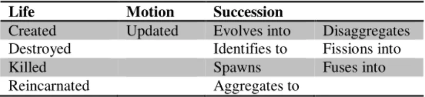
For the temporal component, the author took into account instant changes (valid–time) avoiding duration changes (changes that happen during a certain period); although the author justifies that instant changes fit many application domains, this assumption is in fact a shortcoming of his proposal. The model describes spatio-temporal changes enriching the spatio-temporal constructs defined in the History Graph Model (see Section 2.5) and the event-oriented approach of Claramunt and Thériault (see Section 2.4 – extended-versioning). The representation of the time dimension is based on the life-motion-succession scheme (LMS-scheme), i.e., the three elements that are concerned with changes of historical-spatio-temporal entities (see Table 4).
Considering that geographic entities have at least four dimensions (identity, spatial, thematic, and temporal), the author defines what he calls a minimal structure to manage semi-structured geographic entities. An OEM (Object Exchange Model) graph-like representation of the four dimensions of an entity is the key component in the model. With the spatial, thematic, and temporal definitions, the “recording of history” is achieved thanks to “the relationships established between entities involved in a temporal construct of type succession.” (Stefanakis 2003, p. 523). Although the model does not allow tracking the evolution of attributes with extreme accuracy, the thematic dimension allows it to relate the attributes to spatial components considering their variation in time.
Table 4. Temporal constraints in the LMS-Scheme (based on Stefanakis 2003)
Life Motion Succession
Created Updated Evolves into Disaggregates Destroyed Identifies to Fissions into
Killed Spawns Fuses into
Reincarnated Aggregates to
In order to demonstrate how the model works, Stefanakis defines a case study based on a cadastral scenario in which a set of application domain queries to manage spatio-temporal geographic data were solved successfully. The flexibility that this proposal shows in supporting spatio-temporal queries is due to the use of the LOREL query language (Abiteboul et al. 1997) for retrieving information. However, complex spatio-temporal queries are not supported; the way in which the “recording history” is tracked (linking records up and down) does not allow querying spatio-temporal changes to take into account more than one temporal stage. This shortcoming obviously affects the general performance. The major restriction that arises from this model is the impossibility of recording duration changes, since the behaviour of a wide number of geographic entities in several domains is described by durations (periods) rather than instants. In contrast to the potentialities offered in Del Mondo et al. (2013), this model is not able to take the most from LOREL because of the rigidity of the graph.
Feature-Based Temporal Model (FBTM). By extending the key concepts of the spatio-temporal object (ST-object) developed in the Object-Oriented Spatio-Temporal Model (OOST) (Worboys 1992b, Worboys
1994a,b) (see Section 2.8) and the Three-Domain Model (TDM) (see Section 2.3), Choi et al. (2008) proposed the Feature-Based Temporal Model (FBTM) to “represent changes of both space and theme independently.” (p. 1). The authors consider three types of changes: (i) geometry changes over time “along with theme changes”; (ii) geometry changes over time “without theme changes”; and (iii) theme changes over time “without geometry changes”. In contrast to the TDM and OOST, the FBTM uses single-feature identifiers to associate space, theme, and time as opposed to a domain link table (the links between semantic, spatial, and temporal objects applied to the TDM) and enhances the “OOST-model by adding an object identifier for thematic changes.” (p. 5).
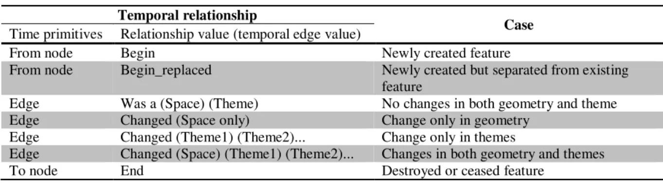
The model allows one to track the change history by maintaining persistent object identifiers for changes in space. To track the feature history and enhance the performance by removing the need to execute topological comparisons during the query processing, the authors have modified the ISO’s temporal schema (ISO 2002) and incorporated an explicit temporal relationship structure. The ISO’s temporal primitives (nodes and edges) are used to construct an explicit temporal relationship that allows storing the “temporal topology and the types of changes for spatial and thematic queries over time.” (Choi et al. 2008, p. 5). Specifically, “seven types of temporal relationships” are defined (see Table 5). This model has limitations to capture continuous changes; discrete changes of features are modelled using linear time. The implemented prototype shows the feasibility of the proposal and the case study (land use) demonstrates the querying performance.
Table 5. Temporal relationships with time primitives (Choi et al. 2008)
Temporal relationship
Case Time primitives Relationship value (temporal edge value)
From node Begin Newly created feature
From node Begin_replaced Newly created but separated from existing feature
Edge Was a (Space) (Theme) No changes in both geometry and theme Edge Changed (Space only) Change only in geometry
Edge Changed (Theme1) (Theme2)... Change only in themes
Edge Changed (Space) (Theme1) (Theme2)... Changes in both geometry and themes
To node End Destroyed or ceased feature
This model shows clearly the advantages of representing temporal changes and theme changes independently, mainly for querying processes and for tracking attribute modifications. It also provides evidence of several disadvantages of the ISO standard regarding changes of features over time. It must be noted that the ISO standard has been under revision status (90.92) since 2008. The FBTM could be catalogued as a complementary approach in the evolution of spatio-temporal modelling in GIS, since it proposes a new approach considering as its focus the third basic component of geographic information, i.e. theme, which has usually been treated as a secondary element in previous proposals (i.e., as an attribute of spatial objects).
In the same line of thought, and based on the previous relational/object-oriented and spatio-temporal data models, Wu et al. (2008) present a proposal to describe feature changes through the Change-of-Feature Based Spatio-Temporal Object-Relational Data Model. Although the authors argue for extending the FBTM by emphasizing the concepts of event and state, they do not provide enough information about how the model is extended.
Mathematical feature-based modelling. A mathematical feature-based modelling proposal, formalized trough spatio-temporal functions, was described by Maldonado Ibañez and Vázquez Hoehne (2010). The authors proposed a set of spatio-temporal geometrical primitives for the representation of dynamic features considering the topological relationships derived from them. The model considers not only spatial topological relations, but also temporal relations as for the occurrence of the phenomena, e.g., after, before, and during. The spatio-temporal context follows the relationships proposed by Claramunt and Jiang (2000). The primitives consist of a set of three-dimensional structures which are the result of three basic spatial primitives (arc, surface, and node)