Development of a knowledge base to support the consideration of
groundwater protection in land-use planning
Jérôme Cerutti1*, Roxane Lavoie1 and René Lefebvre2
1 École supérieure d'aménagement du territoire et de développement régional (ESAD), Université Laval, Pavillon Félix-Antoine-Savard – FAS 1616, 2325 allée des Bibliothèques, Québec (QC), G1V 0A6, Canada.
2 Institut national de la recherche scientifique (INRS), Centre Eau Terre Environnement, 490 rue de la Couronne, Québec (QC), G1K 9A9, Canada.
*Corresponding author. ORCID: 0000-0002-1162-9299; Tel.: +1 (418) 656-2131:4788; E-mail address: [email protected]
Abstract
Groundwater is an essential resource for water supply, but it is vulnerable to the potential impacts of contaminant emissions from human activities. It is widely recognized that the effects of human activities on groundwater quality and quantity can be mitigated, in large part, by appropriate land-use planning becaland-use it plays a central role in groundwater protection and conservation. However, groundwater-related issues are not commonly considered in the land-use decision-making process. The main objective of this paper was to develop a decision-support system (DSS) to fill the gap between groundwater resources management, territorial development and the land-use institutional framework. To achieve this objective, it was necessary to establish a dialogue with decision makers to identify their needs. Then, by linking human activities and their related contaminants and impacts, it was possible to identify land-use planning actions that could support groundwater protection. This research resulted in a tool named “Base de connaissances – aménagement du territoire et eau souterraine” (BC-ATES) [Knowledge base – Land use planning and groundwater]. This tool was tested using Microsoft Access. It includes all the information identified as relevant by land-use planners in the decision process regarding groundwater needs.
Keywords
Land-use planning; groundwater management; decision-support system; knowledge/data base.
Acknowledgements
Authors wish to thank land-use planners from the regional county municipalities of Appalaches, l’Islet, Lotbinière, Montmagny and Nouvelle-Beauce for participating in the development of an adapted tool for land-use planners. We also thank François Lajoie from the Organisme de Bassin Versant de la Côte-du-Sud for his help in recruiting participants. We acknowledge Sonja Behmel and Hervé Dandjinou from Watershed Monitoring for their precious help in building and validating the database. We also acknowledge the Réseau québécois sur les eaux souterraines (RQES) and l’Institut national de la recherche scientifique (INRS) for information on their groundwater data and groundwater research methodology. This research project was funded by the Centre de
recherche en aménagement et en développement (CRAD) of Laval University, Quebec City (QC),
1. Introduction
The use of groundwater resources for water supply is widespread. Compared to surface water, groundwater offers many advantages in terms of quality and quantity (Gleeson et al. 2010; Zektser et al. 2004). For example, groundwater supplies drinking water to more than 37% of the US population (estimated by Maupin et al. 2014) and more than 75% in Europe (European Union et al. 2008). In the province of Québec, Canada, 20% of the population depends on groundwater for their water supply (MDDELCC 2015). Furthermore, the use of groundwater resources is common for industrial activities and agriculture (Zektser et al. 2004).
However, groundwater faces many pressures from human activities (e.g., Changming et al. 2001; Custodio 2002; Gleeson et al. 2010; Trabelsi et al. 2005). Indeed, it is sensitive to overexploitation and vulnerable to potential contamination by surface activities (Granato and Smith 2002). Moreover, its regeneration capacity is slow and this aggravates the pollution impacts on a resource for which the assessment of quantity and quality is already complex and costly (Zektser et al. 2004). Thus, terrible consequences could occur when a groundwater supply is contaminated. One example in the province of Ontario (Canada) is the contamination of Walkerton’s municipal groundwater supply by E. coli bacteria in May and June 2000. It was a public health disaster with 7 deaths and 2,300 people infected in a municipality with about 5,000 inhabitants (Driedger et al. 2014; Hrudey et al. 2002; Mullen et al. 2006; O’Connor, 2002). The economic impact of this tragedy was estimated at CDN $64.5 million (Livernois 2002; Vicente and Christoffersen 2006). Because the bacteria from agricultural activities were spread by floods, this example points to the need for better land-use planning to adequately protect groundwater upstream of its withdrawal.
Indeed, as early as 1991, UNESCO issued a warning regarding the decline in groundwater quality resulting from inadequate land-use planning (Vrba et al. 1991). Several authors demonstrated a causal link between human activities and the quality and quantity of groundwater, including case studies (Collin and Melloul 2001; Conacher 1994; Foster and Cherlet 2014; Foster 2001; Haase 2009; Hayashi et al. 2009; Lerner and Harris 2009; Onodera et al. 2008; Scanlon et al. 2005; Tang et al. 2005; US EPA 2013). Yet, the integration of groundwater into land-use decision making continues to lag behind in the province of Québec, Canada (Caron et al. 2016; Lavoie, 2013). The problem persists, despite the existence of a regional groundwater resources assessment program (Programme d’acquisition de connaissances sur les eaux souterraines [PACES]) that covered more than 75% of municipal land in Québec between 2009 and 2015 (MDDELCC 2015; RQES 2012). There are many reasons for this lack of integration of available data: inadequate human and financial resources; lack of cooperation between the water stakeholders; and, available hydrogeological data too technical and not adapted to the needs of land-use decision makers (Lavoie 2013). This echoes Armstrong’s (1990) assertion that groundwater data have been collected on a large scale, but from a variety of independent sources and organized without links that could exist between them. Accordingly, these databases fail to answer the multidisciplinary problem of groundwater management and, de facto, are of little use to decision makers.
Thus, the current situation may be summarized as follows: there are available data on groundwater resources in Québec, a dynamic land-use framework exists, and groundwater supplies a large part of the population. The question that must then be asked is how might we interconnect the information to help land-use planners develop their territory while minimizing the potential risk of pollution of their main source of drinking water? The aim of this study was to develop a decision-support tool in a relational database management system (RDBMS) that could be applied to a multidisciplinary activity such as land-use planning and groundwater protection. The model introduced by Codd (1970) is still the standard in databases. It is a collection of logically connected data without redundancy (Gabillaud 2009) that allows the storage of data and links, but also the manipulation and interrogation of the data while ensuring their protection, backup and access (Akoka and Comyn-Wattiau 2001; Favennec 1998; Nguyen and Meier 2006; Ponniah 2003; Welling and Thomson 2009). These advantages appear to have been adapted, since land-use planners do not have the time to develop a database from scratch, but do have the time to modify and use a database in their daily practice.
2. Design
2.1. Description of the case study
This study is part of a research project undertaken in the Chaudière-Appalaches region located to the South of Quebec City (province of Québec, Canada), which deals with the integration of groundwater into land-use planning. Groundwater data in this region were derived from a regional groundwater resources assessment program (Programme d’acquisition de connaissances sur les
eaux souterraines [PACES]) supported by the Government of Québec between 2009 and 2015,
with projects in different areas carried out by universities (INRS in the case of Chaudière-Appalaches) in collaboration with regional water stakeholders. The purpose of this program was to provide a picture of groundwater resources across municipal land in Québec. Data were published in the PACES-Chaudière-Appalaches (PACES-CA) project report in March 2015 (see Lefebvre et al. 2015). This PACES project covered the entire Chaudière-Appalaches region (excluding the city of Lévis), an area of 15,601 km2.
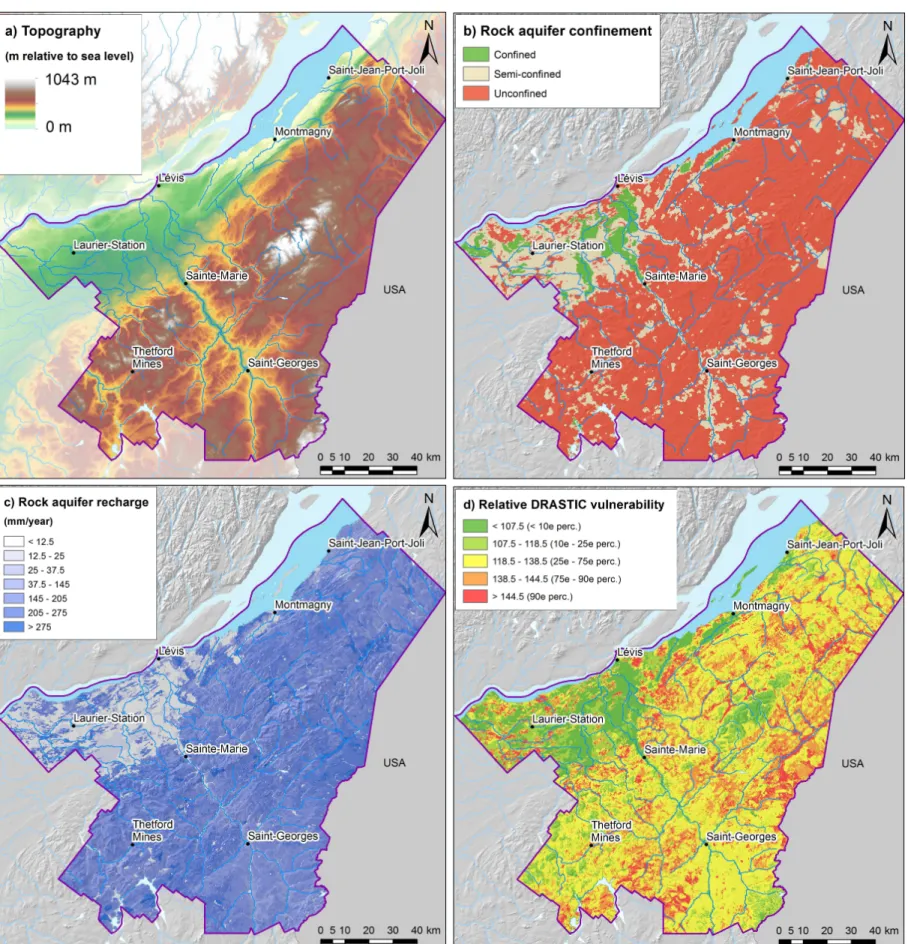
Figure 1: Maps of the Chaudière-Appalaches study area showing:(a) Topography represented by the digital elevation model (DEM) (Lefebvre et al. 2015, p.9); (b) regional rock aquifer confinement conditions (based on the nature and thickness of surficial sediments) (Lefebvre et al. 2015, p.92); (c) recharge of the regional rock aquifer (Lefebvre et al. 2015, p.108), (d) Vulnerability of the regional rock aquifer based on the DRASTIC index (Lefebvre et al. 2015, p.116)
The Chaudière-Appalaches region comprises three hydrogeological contexts: the St. Lawrence Lowlands, the Appalachian Valleys and the Appalachian Highlands. The topography of the area varies between 0 m to 1043 m (Figure 1a). The region is characterized by a continuous regional aquifer formed by naturally fractured rock and some local granular aquifers. Over most of the area, the regional rock aquifer is unconfined, but confined conditions are dominant in the St. Lawrence Lowlands (Figure 1b). The average annual recharge of the fractured rock aquifer is 166 mm/year (Figure 1c), with recharge far exceeding the groundwater exploitation rate, which is generally less than 10% of recharge except in some municipalities where it exceeds 20% in the St. Lawrence Lowland. The maximum DRASTIC vulnerability index (Aller et al. 1987) is between 160 and 180, which is considered as a medium to high vulnerability (Figure 1d). With a maximum of 168, the aquifers in the area does not reach a very high vulnerability. The most vulnerable areas are found where the aquifer is unconfined (Figure 1b) and has a high recharge (Figure 1c). Groundwater is also an important part of water supply in the region. Nearly 42% of the water used comes from groundwater and 32% of the population is supplied by private wells. Furthermore, nearly 60% of municipal systems are supplied by groundwater.
From an institutional and land-use planning perspective, the Chaudière-Appalaches region is made up of nine regional county municipalities (Municipalité régionale de comté [MRC]) comprising 135 municipalities with a total population of 278,234 inhabitants (MAMROT, 2016). The region is predominantly rural and farming occupies two thirds of the inhabited area (Services Québec, 2015). As part of this research, five MRC land-use planners (regional stakeholders) volunteered to participate in the development of the decision support tool (Table 1). Their interest in participating in this research stems mainly from the recent availability of groundwater data covering their region, but also from a lack of available tools to consider groundwater in land-use planning.
Table 1—Portrait of participating regional county municipalities (MRC). (Data: final report and deliverable 26B of PACES-CA, 2015; MAMROT, 2016).
Based on the methodological examples of Connolly and Begg (2005), Akoka and Comyn-Wattiau (2001), and some elements of Ponniah (2003), the design of the knowledge base was completed in three phases: conceptual, logical and physical. The main classes of the knowledge base were first developed, followed by secondary classes. Classes are data tables that group information categories (attributes) composed by data. For example, the class "Reference" is composed of attributes such as the name of the document used, the name of the organization that created the document and its year of publication. To identify this information, the participation of regional stakeholders was continuous and represents a benefit for this study. Indeed, the meetings with stakeholders made it possible to learn more about their relationship with groundwater resources found within their territory. Furthermore, the discussions also identified their needs and expectations in order to make the tool as functional as possible.
2.2.1. Identifying the purpose of the tool and its potential uses
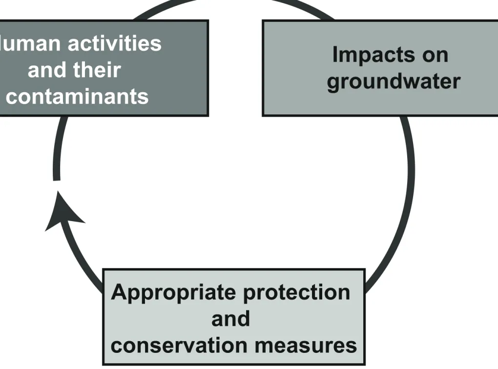
First, this study defined the basis of the tool (purpose and uses). Its purpose is to reduce the impact of human activities on groundwater through sustainable land-use planning (Figure 2).
Figure 2 - Dynamics considered to reduce the impact of human activities on groundwater resources through land-use planning
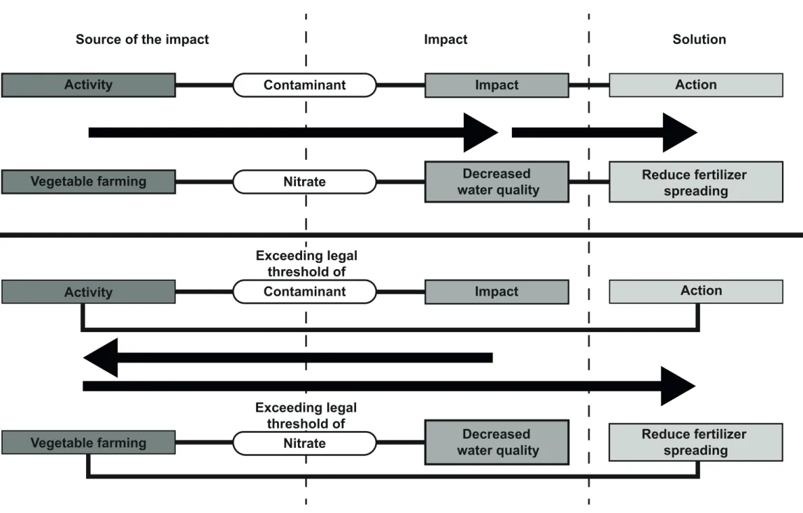
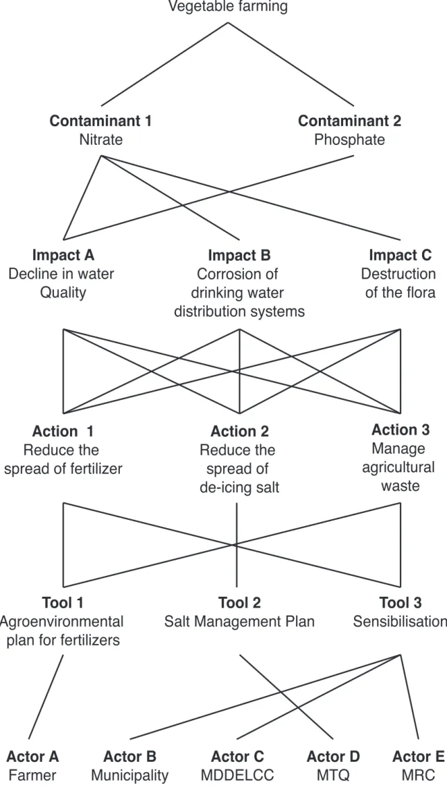
Then, three purposes for the tool were identified through exchanges with the participating regional stakeholders. Two of the purposes concern actions taken to prevent contamination; the third purpose is in response to a proven problem (Figure 3).
Prevention: If the regional or local authorities had projects and developments that they would like to implement within their territory, they would use the knowledge base to:
• Identify the activity that represents the lowest risk or the most tolerable potential impact on groundwater resources.
• Identify the measures to be implemented during the development of a project to reduce potential impacts on groundwater.
Reaction: If the regional or local authorities observed any degradation of groundwater quality (on infrastructure, in the environment, etc.), they would use the knowledge base to:
• Identify the probable sources of contamination by identifying activities releasing this type of contaminant.
Figure 3 – The purposes of the tool: Prevention and reaction illustrated by the example of vegetable farming
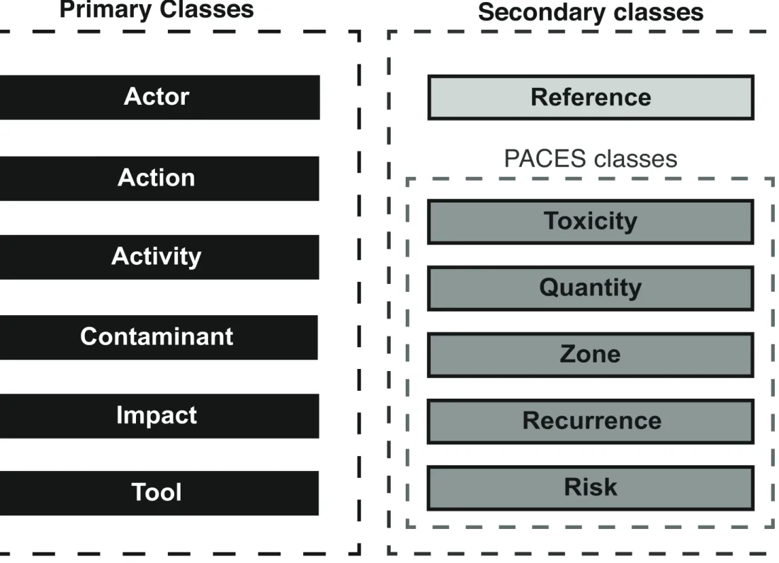
2.2.2. Identification of Primary, Secondary and Attribute Classes
After the identification of the purpose and uses of the tool, key elements emerged and were used to define the different classes of the tool. For example, the need for knowledge about the available action tools or the actors at the origin of the classes “Tool” and “Actor”. The identification process of the tool classes was achieved during individual meetings with participating regional stakeholders. This process was carried out from the inside out, starting with primary classes—considered as absolutely necessary by stakeholders—, followed by secondary classes—considered as interesting information—, and including the “PACES” classes that make a link between tool and the data from the governmental program (Figure 4). For validation, identified key elements were regrouped and sent by email to stakeholders. Through discussions and consensus between all stakeholders, primary and secondary class were thus validated.
The primary classes are:
• “Actor”: lists the actors who have the legal competence or who participate in the implementation of an action. These actors are government agencies and organizations, the population, but also private companies. The information comes from provincial laws and regulations, ministerial directives and examples of actions implemented by other regional or local stakeholders at the provincial scale.
• “Action”: lists actions that the land-use planner could implement to avoid or correct a case of contamination. These actions are identified through legislative sources, ministerial directives and planning documents at the provincial scale.
• “Activity”: identifies the activities present in the territory on the basis of the land-use code (Code d’utilisation des biens-fonds, CUBF) from Québec’s property assessment manual (Manuel d’évaluation foncière du Québec [MAMROT 2010a]) edited by the provincial government. This kind of property codification is the key to making this tool work. The CUBF takes the physical and economic inventory of the provincial territory by identifying its different uses (MAMROT 2010b). The CUBF has different degrees of accuracy from one to four digits. Each usage has a unique four-digit code. For example, the code CUBF 1542 corresponds to the use “orphanage” categorized in 154 “House of retreat and orphanage”, in Category 15 “dwelling in common”, all classified in the use Type 1 “residential”. In order for the tool to be adapted to day-to-day practices, meetings with land-use planners concluded that the four-digit CUBF code was the most accurate level of precision regarding human activities.
• “Impact”: identifies the potential impact of contaminants categorized by types of impacts (infrastructure, environment, human health, etc.). This information was identified through various sources, such as governmental health agencies or the scientific literature.
• “Contaminant”: identifies the main contaminants that can be found in groundwater. The data from PACES Protocol 23 are used to produce an index of the density of potentially groundwater-polluting human activities (Audet-Gagnon et al. 2013). The aim of this protocol is to assess the potential impact of anthropogenic activities in terms of the perceived risk on the quality of groundwater resources.
• “Tool”: lists the tools with which actions can be implemented, such as awareness raising, financial incentives and fines, planning documents and legal regulations. These tools were identified through the provincial legislation and examples of actions were based on other regional or local stakeholders at the provincial level.
Secondary classes are used mainly to add information. It is possible to subdivide the secondary classes into sub-classes resulting from PACES Protocol 23. The level of threat to groundwater quality represented by a CUBF activity is calculated according to PACES protocol 23 as follows: potential impact (class “Risk”) = (toxicity of contaminants [class “Toxicity”] + quantity of contaminants [class “Quantity”] + activity area of impact [Class “Zone”]) × recurrence of contaminant releases (class “Recurrence”) (Audet-Gagnon et al. 2013). The knowledge base does
not allow users to calculate the risk. It serves only to integrate the information produced by the protocol to inform land-use planners. Secondary classes include:
• “Reference”: lists examples of the implementation of actions and the legal documents used as a basis for the action. These are planning documents from regional and local land-use planners having implemented the same action, or a similar action. “Reference” also contains articles of law requiring the implementation of certain actions, or ministerial directives that advise on the implementation of these actions.
• “Toxicity”: indicates the toxicity of contaminants associated with an activity. PACES Protocol 23 uses the toxicity classification of pure products listed in an information system for hazardous materials in workplaces (Système d’information sur les matières dangereuses
utilisées au Travail, SIMDUT) developed by the provincial government. Pure products are
classified under three sub-categories according to their quantity in the contaminant. For each of the three products, they are categorized as nontoxic, toxic or very toxic.
• “Quantity”: indicates the quantity and concentration of contaminants associated with the activity. The quantity of contaminants can be small, large, or very large. Contaminant concentration may be low, medium or high.
• “Zone”: refers to the potential impact area of the activity. It is subdivided into three spatial scales: punctual (10 m2), local (100 m2) and regional (1 km2).
• “Recurrence”: indicates the potential contamination of an activity over time. If the releases are systematic and related to the nature of the activity, they are considered as recurrent. In other cases, they are considered as accidental.
• “Risk”: indicates the potential impact of each CUBF activity on the quality of groundwater. Activities are divided into four risk classes: low, moderate, high, very high.
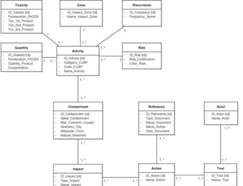
Following the identification of the different classes that make up the knowledge base, the attributes of each class were defined (Appendix 1). Finally, the validation of the attributes within the classes was carried out with participating land-use planners through emails.
2.3. Logical design
During the logical design, the associations – link – and the multiplicity – how the elements are linked – between each class were identified. Figure 5 illustrates those elements using an example (vegetable farming). This phase was carried out in three parts to ensure better readability.
Figure 5: Associations (“Links”) illustrated with the example of the activity “Vegetable Farming”
The purpose of the first part (non-illustrated in Figure 5) was to establish a link between the PACES and the activities inside the database. All the PACES classes are characterized by a
one-to-many multiplicity with the class “Activity”. For example, a degree of risk may involve several
associated with activities such as “Vegetable farming”, “Lumbering industry” or “Golf course”, but “Vegetable farming” is only associated with “Moderate” risk and not “Very High”, “High” or “Low” risk.
The purpose of the second part was to link the activities and the solutions (actions) through the causalities made by the contaminants. Each association between these classes is characterized by a many-to-many multiplicity. For example, “Vegetable farming” is associated with contaminants such as “Nitrate”, “Phosphate” or “Coliform and non-coliform bacteria”. “Nitrate” is also associated with other activities such as “Chalet or vacation house” or “Cereals, oilseed and leguminous plant crops”. The same logical process was repeated for each element to establish association and multiplicity between them.
The purpose of the third part was to link the solutions to the right tools and actors. Each association is characterized by a many-to-many multiplicity. For example, an action may be implemented by several tools and a tool can implement several actions.
Finally, the verification and validation of the links between classes were carried out with database professionals during dozens of meetings. The objective was to identify on paper the problems that could occur before implementing the concept in the database management system. Moreover, this step aimed to be sure about the logical construction of the concept.
2.4. Physical design
The physical design served to identify the type (numerical, textual, etc.) of each attribute. These elements are presented in Appendix 2. The knowledge base was validated during meetings with database experts to ensure that all the concept did not contain logical mistakes and to verify if the links between classes were well designed. Then the concept was implemented according to the model shown in Figure 6, which illustrates how the previously described blocks fit together.
Figure 6 – The BC-ATES physical implementation model 3. Application
Results of the design produced the “Base de connaissances – Aménagement du Territoire et Eau Souterraine” (BC-ATES) [Knowledge base – Land use planning and groundwater] decision support tool. To test the decision-support system, it was implemented in the Microsoft Access software.
During meetings, regional stakeholders were asked to identify the activities they would like to see in the knowledge base test (Table 2). Participants highlighted agricultural activity, which represents a large part of the land-use present within their territories. Then, other elements that could have an impact on groundwater in their territories were discussed, such as resorts, oil pipelines, industries, golfs, logging, and the road network. Thus, we can consider that these elements represent as many territorial realities as elements of concern for the regional stakeholders. According to the wishes of stakeholders, twelve activities were selected based on three criteria: the activity had to exist in at least two of the five regional county municipalities; the potential risk of the activity; and, its impact area. For the potential risk and the impact area, the selected activities had to be as heterogeneous as possible in order to provide a variety of scenarios to the knowledge base. The presence of the activities was noted through land-use planning documents and economic portraits of the region; the risk and the impact area were identified by PACES Protocol 23 as previously described.
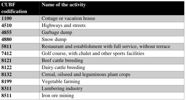
Table 2 – The twelve activities selected for the BC-ATES test
Following the choice of activities, all the data were inserted sequentially for one activity at a time. For the 12 activities, it was possible to identify 24 actions, 16 actors, 33 contaminants, 25 impacts and 22 tools (Appendix 3).
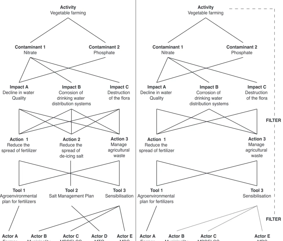
3.2. Information Filtering
After implementing information inside the knowledge base, the first queries - a request for information from a database - revealed that the information had to be filtered. Indeed, to avoid inexact information in the results of the query, specific criteria (the filters) had to be added inside the query. For example, it is necessary to filter the information for activities releasing the same contaminating product and having the same impact in order to obtain the appropriate action to apply to the activity. For instance, the action of “Reduce the spread of de-icing salt” should not concern the activity “Vegetable farming”. Thus, two filters must be inserted to correctly identify the Activity-Action and Activity-Actor combination (Figure 7). These filters may take many forms and can be inserted directly into coding. However, as part of this research, they were implemented in Microsoft Access by adding the “Code_CUBF” attribute in the “Action” and “Actor” classes. These attributes allowed to create associations between the classes and acted as filters. As a list of choices, this attribute retrieves the information from the “Activity” class and makes it possible to associate an activity with an action and an activity with an actor.
Figure 7 – Illustration of the use of query filters inside the tool.
After formatting and implementing the knowledge base, access to information was put in place. After meetings with regional stakeholders, a form was developed within the knowledge base to gain access to the information (Appendix 4). The first version of the form consisted of drop-down lists and search fields, which only allowed the user to browse the information with no possibility to modify or creating data inside the knowledge base. Therefore, it could only be used to query information and minimize the risk of untimely changes made to the data.
In the first part of the form, in a fixed header, water stakeholders can quickly find general information about activities such as the code of the activity (attribute “Code_CUBF”), the category of the activity (attribute “Category_CUBF”), the name of the activity (attribute “Name_Activity”) and the level of risk linked to the activity (class “Risk_Codification”). Users can search for an activity by its code CUBF or by its name. Using a fixed header allows users to scroll down the page without losing sight of the activity to which the data relate.
Then, in the second part of the form, users have the final part of the general information about the activity such as the frequency of contaminant releases (attribute “Frequency_Name”) and the impact area of the activity (attribute “Name_Impact_Zone”). Two main tables are visible through sub-forms. First, the contaminants rejected by the activity and their impacts (class “Contaminant”). Inserted as a sub-sub-form, users have details regarding identified impacts (class “Impact”) for each contaminant. Then, another sub-form makes the synthesis of all the impacts (class “Impact”) linked to the activity.
Lastly, in the third part of the form, information about land-use planning actions and how to implement them are shown. The same process of sub-sub-form is reproduced as this process allows precise access to information. A sub-form listing the actions (class “Action”) is inserted, allowing users to have a clear and quick information about all the actions that can be implemented regarding the activity. Then, a first sub-sub-form indicates which tool (class “Tool”) is necessary to implement the action and, for each action, it is possible to consult the various tools available. Finally, the second sub-sub-form indicates the actor (class “Actor”) that is legally responsible or related to the tool necessary to implement the action.
Thanks to filtering, the information from the form, sub-form and sub-sub-form allows users to find the right actions to implement according to the activity sought. Moreover, when it comes to awareness, the actors are filtered according to their competence with regard to the activity.
4. Discussion
One of the most important issues in the development of BC-ATES was the identification of the most relevant stakeholder who might use the knowledge base. The choice was directed towards regional county municipalities (MRC) for three reasons. First, MRCs are at the crossroads between the ministries (who make the decisions) and the municipalities (which have most of water
competencies). Secondly, the ministerial level is too far removed from local realities and the municipal level cannot act outside its administrative boundaries. Thirdly, municipalities would not have had sufficient financial and human resources to use such a tool. The second challenge was to identify the easiest tool that spatial planners could use. Relational database management systems (RDBMS) were chosen because they offer flexibility which, as part of this study, enables the effective link between information from the territory, the groundwater resources and the land-use institutional framework. Thus, land-use planners have quick access to the information they need concerning the potential impact of activities on groundwater. However, many limitations were identified.
The most important limitation of BC-ATES is the need to have a land-use planning institutional framework and a property codification, without which it would be impossible to adjust this tool. Another main limitation is the availability of groundwater data and the knowledge transfer of these data to land-use planners. Indeed, such a tool requires programs producing knowledge on groundwater resources that have been carried out previously. In Québec, the PACES has produced such knowledge in most regions, including the test region used to develop the tool. This implies a significant investment by governmental agencies. Moreover, even after obtaining the data on the resource, it is necessary to efficiently transfer the knowledge to water stakeholders who must exploit these complex hydrogeological data. In Québec, a groundwater knowledge transfer program was initiated in 2014. By 2018, it will have covered all regions where PACES projects have previously been carried out (RQES 2016). Another limitation is the need to continuously update the knowledge base. Indeed, the institutional framework is in constant evolution and the tool must be dynamic to be relevant in the long term. Thus, this implies that human resources must be allocated to update the tool. The last limitation regards aspects such as mentalities towards groundwater resources that are struggling to evolve or the lack of political will which hampers the use of such a tool. Indeed, protection and conservation of groundwater can be seen as a constraint on the development of municipalities, even though groundwater resources often represent an important part of their water supply.
Finally, the knowledge base could be enriched by the integration of economic components such as the cost of the actions and the quantification of the economic losses due to the pollution of the water resources. During meetings with the MRCs, the addition of an economic variable was requested in order to support action proposals presented to elected representatives. However, given the complexity of integrating economic components, it was proposed to integrate similar implementation examples offering an idea of the costs of an action. Furthermore, the association class linking the “Contaminant” and “Impact” classes could contain a “Reference” attribute that would allow the user to know where the information originates from.
The objective of this research was to develop a decision-making support tool to fill the gap between information about groundwater resources, territorial development and the institutional framework of land-use planning. To achieve this objective, three major methodological steps were followed to develop a decision support system. First, a conceptual design identified the purpose of the tool, its uses and the content of the primary classes, secondary classes and attributes. This was followed by a logical design to identify the associations and the multiplicity between each class. In other words, this stage made it possible to identify the links between the classes. Finally, a physical design identified the type of each attribute within the class. The result of this research is a tool known as “Base de connaissances – Aménagement du Territoire et Eau Souterraine” (BC-ATES) [Knowledge base – Land use planning and groundwater]. BC-ATES was tested using Microsoft Access software.
The development of BC-ATES would not have been possible without the participation of land-use planners from the Chaudière-Appalaches region. Indeed, as regional stakeholders, their participation was crucial to the conceptual design and different stages of validation. Thanks to their help, it was possible to adapt the tool as closely as possible to their land planning practices. Furthermore, the participation of database professionals resulted in the development of a user-friendly tool.
BC-ATES faces some limitations. Indeed, for the development of such a decision-making tool, a land-use planning framework is crucial, as is the existence of groundwater information. Furthermore, the tool must be updated continuously. This limitation is important because it involves identifying the organization responsible for these updates and setting aside the necessary resources to work on the updates. Finally, this type of tool can faces political and social obstacles, which would limit its usefulness.
Despite these limitations, BC-ATES is a promising tool because it integrates, in one location, a set of information that can help land-use planners to consider groundwater in their planning. Not only is BC-ATES making users aware of the source of groundwater contamination, but it also proposes solutions through actions that can be implemented in land-use planning to prevent or reduce contamination. Moreover, BC-ATES indicates the legal tool with which it would be possible to implement an action, as well as the actor having the legal competence to carry out the action. Therefore, this tool offers significant potential to help protect and conserve groundwater in the context of land-use planning.
Bibliography
Akoka J, Comyn-Wattiau I (2001) Conception des bases de données relationnelles [Designing
relational databases]. Vuibert informatique, Paris
Aller L, Bennett T, Lehr JH, Petty R, Hackett G (1987) DRASTIC: A Standardized System for Evaluating Ground Water Pollution Potential Using Hydrogeologic Settings. National Water Well Association, Dublin, OH, USA
Armstrong MP (1990) Database integration for knowledge based groundwater quality assessment. Computers, Environment and Urban Systems 14:187–201. doi: 10.1016/0198-9715(90)90008-H Audet-Gagnon F, Roy M, Ballard J-M, Carrier M-A (2013) Protocole pour la préparation du Livrable 23 - Indice de densité d’activités anthropiques. (Programme d’acquisition de connaissances sur les eaux souterraines du Québec) [Protocol for the preparation of Deliverable
23 - Density index of anthropogenic activities. (Québec's regional groundwater resources assessment program)]. Université du Québec en Abitibi-Témiscaminque (UQAT) en collaboration
avec l’Institut national de la recherche scientifique, Centre - Eau Terre Environnement (INRS-ETE)
Caron S, Cerutti J, Marleau Donais F, Vallières L (2016) Eau souterraine : une planification à la source de la protection [Groundwater: land-use planning at the source of its protection]. Dissertation, Université Laval
Changming L, Jingjie Y, Kendy E (2001) Groundwater Exploitation and Its Impact on the Environment in the North China Plain. Water International 26:265–272. doi: 10.1080/02508060108686913
Codd EF (1970) A relational model of data for large shared data banks. Communications of the ACM 13:377–387. doi: 10.1145/362384.362685
Collin ML, Melloul AJ (2001) Combined land-use and environmental factors for sustainable groundwater management. Urban Water 3:229–237. doi: 10.1016/S1462-0758(01)00049-8
Conacher AJ (1994) The integration of land-use planning and management with environmental impact assessment: some Australian and Canadian perspectives. Impact Assessment 12:347–372. doi: 10.1080/07349165.1994.9725874
Connolly TM, Begg CE (2005) Systèmes de bases de données : approche pratique de la conception, de l’implémentation et de l’administration [Database Systems: A Practical Approach to Design,
Custodio E (2002) Aquifer overexploitation: what does it mean? Hydrogeology Journal 10:254– 277. doi: 10.1007/s10040-002-0188-6
Driedger SM, Mazur C, Mistry B (2014) The evolution of blame and trust: an examination of a Canadian drinking water contamination event. Journal of Risk Research 17:837–854. doi: 10.1080/13669877.2013.816335
European Union, European Commission, Directorate-General for the Environment (2008) Protection des eaux souterraines en Europe: la nouvelle directive sur les eaux souterraines : une consolidation du cadre réglementaire de l’UE [Groundwater protection in Europe: the new
groundwater directive: consolidation of the EU's regulatory framework].
Favennec J-P (1998) Raffinage du pétrole (Le) [Oil refining]. Tome 5. Exploitation et gestion de la raffinerie. Editions TECHNIP
Foster S, Cherlet J (2014) The links between land use and groundwater – Governance provisions and management strategies to secure a “sustainable harvest.” Global Water Partnership
Foster SS. (2001) The interdependence of groundwater and urbanisation in rapidly developing cities. Urban Water 3:185–192. doi: 10.1016/S1462-0758(01)00043-7
Gabillaud J (2009) Oracle 11g: SQL, PL/SQL, SQL*Plus. Editions ENI
Gleeson T, VanderSteen J, Sophocleous MA, et al (2010) Groundwater sustainability strategies. Nature Geoscience 3:378–379. doi: 10.1038/ngeo881
Granato GE and Smith KP (2002) Robowell — Providing Accurate and Current Water-Level and Water-Quality Data in Real Time for Protecting Ground-Water Resources: US Geological Survey Fact Sheet FS-053-02:6. In: USGS. https://pubs.usgs.gov/fs/fs05302/robo.htm
Haase D (2009) Effects of urbanisation on the water balance – A long-term trajectory. Environmental Impact Assessment Review 29:211–219. doi: 10.1016/j.eiar.2009.01.002
Hayashi T, Tokunaga T, Aichi M, et al (2009) Effects of human activities and urbanization on groundwater environments: An example from the aquifer system of Tokyo and the surrounding area. Science of The Total Environment 407:3165–3172. doi: 10.1016/j.scitotenv.2008.07.012 Hrudey SE, Huck PM, Payment P, et al (2002) Walkerton: Lessons learned in comparison with waterborne outbreaks in the developed world. Journal of Environmental Engineering and Science 1:397–407. doi: 10.1139/s02-031
en aménagement du territoire [Strategies to facilitate the integration of groundwater in land-use
planning decision-making]. Dissertation, Université Laval
Lefebvre R, Ballard J-M, Carrier M-A, et al (2015) Portrait des ressources en eau souterraine en Appalaches, Québec, Canada [A Portrait of groundwater resources in
Chaudière-Appalaches, Québec, Canada]. Projet réalisé conjointement par l’Institut national de la recherche
scientifique (INRS), l’Institut de recherche et développement en agroenvironnement (IRDA) et le Regroupement des organismes de bassins versants de la Chaudière-Appalaches (OBV-CA) dans le cadre du Programme d’acquisition de connaissances sur les eaux souterraines (PACES), Rapport final INRS R-1580, soumis au MDDELCC en mars 2015.
Lerner DN, Harris B (2009) The relationship between land use and groundwater resources and quality. Land Use Policy 26:S265–S273. doi: 10.1016/j.landusepol.2009.09.005
Livernois J (2002) The Economic Costs of the Walkerton Water Crisis. Ministère du procureur général, Toronto (ON)
Maupin MA, Kenny JF, Hutson SS, et al (2014) Estimated use of water in the United States in 2010. U.S. Geological Survey, Reston, Virginia
Ministère des Affaires municipales et de l’Occupation du territoire (MAMROT) (2010a) Manuel d’évaluation foncière du Québec [Québec’s property assessment manual] (MEFQ). In: Ministère des Affaires municipales et de l’Occupation du territoire.
http://www.mamrot.gouv.qc.ca/evaluation-fonciere/manuel-devaluation-fonciere-du-quebec/edition-modernisee-depuis-2010/.
Ministère des Affaires municipales et de l’Occupation du territoire (2010b) Codes d’utilisation des biens-fonds [The land-use code]. In: Ministère des Affaires municipales et de l’Occupation du territoire. http://www.mamrot.gouv.qc.ca/evaluation-fonciere/manuel-devaluation-fonciere-du-quebec/codes-dutilisation-des-biens-fonds/. Accessed 9 Aug 2016
Ministère des Affaires municipales et de l’Occupation du territoire (MAMROT) (2016) Répertoire des municipalités : N°12 - Chaudière-Appalaches [Directory of municipalities : N°12 –
Chaudière-Appalaches]. In: Ministère des Affaires municipales et de l’Occupation du territoire.
http://www.mamrot.gouv.qc.ca/repertoire-des-municipalites/fiche/region/12/. Accessed 13 Jun 2016
Ministère du Développement Durable, de l’Environnement et de la Lutte contre les Changements Climatiques (2015) Programme d’acquisition de connaissances sur les eaux souterraines (PACES)
[Regional groundwater resources assessment program]. In: MDDELCC.
http://www.mddelcc.gouv.qc.ca/eau/souterraines/programmes/acquisition-connaissance.htm#premier.
Mullen J, Vladi N, Mills AJ (2006) Making Sense of the Walkerton Crisis. Culture and Organization 12:207–220. doi: 10.1080/14759550600865933
Nguyen DH, Meier A (2006) Introduction pratique aux bases de données relationnelles [Practical
introduction to relational databases]. Springer Science & Business Media
O’Connor DR (2002) Report of the Walkerton Inquiry. Ontario Ministry of the Attorney General, Ontario
Onodera S, Saito M, Sawano M, et al (2008) Effects of intensive urbanization on the intrusion of shallow groundwater into deep groundwater: Examples from Bangkok and Jakarta. Science of The Total Environment 404:401–410. doi: 10.1016/j.scitotenv.2008.08.003
Ponniah P (2003) Database Design and Development: An Essential Guide for IT Professionals. John Wiley & Sons, Inc., Hoboken, NJ, USA
Réseau Québecois sur les Eaux Souterraines (RQES) (2012) Qu’est-ce-que les PACES? [What are
the PACES?] In: RQES.
http://rqes-gries.ca/fr/archives-et-documents/rapports-memoires-et-cartes/260-quest-ce-que-les-paces.html. Accessed 27 May 2016
Réseau Québecois sur les Eaux Souterraines (RQES) (2016) La stratégie de transfert et d’échange de connaissances sur les eaux souterraines [The Groundwater Knowledge Transfer and Exchange
Strategy]. In: rqes. http://rqes.ca/strategie-de-transfert-dechange-de-connaissances-eaux-souterraines/. Accessed 19 Jan 2017
Scanlon BR, Reedy RC, Stonestrom DA, et al (2005) Impact of land use and land cover change on groundwater recharge and quality in the southwestern US. Global Change Biology 11:1577– 1593. doi: 10.1111/j.1365-2486.2005.01026.x
Services Québec (2015) Chaudière-Appalaches (12) - Portail Québec. In: Portail Québec. http://www.gouv.qc.ca/FR/LeQuebec/Pages/ChaudiereAppalaches.aspx. Accessed 13 Jun 2016 Tang Z, Engel BA, Pijanowski BC, Lim KJ (2005) Forecasting land use change and its environmental impact at a watershed scale. Journal of Environmental Management 76:35–45. doi: 10.1016/j.jenvman.2005.01.006
Trabelsi R, Zaïri M, Smida H, Ben Dhia H (2005) Salinisation des nappes côtières : cas de la nappe nord du Sahel de Sfax, Tunisie [Salinization of coastal aquifers : case of the northern Sahel of
US EPA (2013) Our Built and Natural Environments: A Technical Review of the Interactions between Land Use, Transportation, and Environmental Quality (2nd edition). United States Environmental Protection Agency
Vicente KJ, Christoffersen K (2006) The Walkerton E. coli outbreak: a test of Rasmussen’s framework for risk management in a dynamic society. Theoretical Issues in Ergonomics Science 7:93–112. doi: 10.1080/14639220500078153
Vrba J, Aldwell CR, Alfoldi L, et al (1991) Integrated Land-Use Planning and Groundwater Protection in Rural Areas: A Comparative Study of Planning and Management Methodologies. UNESCO, Paris
Welling L, Thomson L (2009) PHP et MySQL [PHP and MySQL]. Pearson Education France Zektser IS, Everett LG, International Hydrological Program (2004) Groundwater resources of the world and their use. UNESCO, Paris
Table 1—Portrait of participating regional municipalities (MRC). (Data: final report and deliverable 26B of PACES-CA, 2015; MAMROT, 2016).
Table 2 – The twelve activities selected for the BC-ATES test
CUBF codification
Name of the activity
1100 Cottage or vacation house
4510 Highways and streets
4855 Garbage dump
4880 Snow dump
5811 Restaurant and establishment with full service, without terrace
7412 Golf course, with chalet and other sports facilities
8121 Beef cattle breeding
8122 Dairy cattle breeding
8132 Cereal, oilseed and leguminous plant crops
8199 Vegetable farming
8311 Lumbering industry
8511 Iron ore mining
Name of the MRC Number of municipalities Population (2016) Surface area (km2) Groundwater use (relative to total water use)
Appalaches 19 42 970 1912,38 47,8 %
L’Islet 14 18 320 2098,80 72,1 %
Lotbinière 18 31 266 1663,49 67,1 %
Montmagny 14 22 750 1692,84 39,1 %
Nouvelle-Beauce 11 37 037 904,78 31 %
Human activities
and their
contaminants
Impacts on
groundwater
Appropriate protection
and
conservation measures
Activity Contaminant Impact Action
Vegetable farming Nitrate Decreased
water quality
Impact Solution
Reduce fertilizer spreading
Activity Contaminant Impact Action
Vegetable farming Nitrate Decreased
water quality
Source of the impact
Exceeding legal threshold of Exceeding legal threshold of Reduce fertilizer spreading
Toxicity
Quantity
Zone
Recurrence
Tool
Actor
Reference
Activity
Risk
Impact
Contaminant
Action
Primary Classes
Secondary classes
PACES classes
Activity
Vegetable farming
Contaminant 1
Nitrate
Contaminant 2
Phosphate
Impact A
Decline in water
Quality
Impact B
Corrosion of
drinking water
distribution systems
Impact C
Destruction
of the flora
Action 1
Reduce the
spread of fertilizer
Tool 1
Agroenvironmental
plan for fertilizers
Action 2
Reduce the
spread of
de-icing salt
Action 3
Manage
agricultural
waste
Tool 3
Sensibilisation
Tool 2
Salt Management Plan
Activity Vegetable farming Contaminant 1 Nitrate Contaminant 2 Phosphate Impact A Decline in water Quality Impact B Corrosion of drinking water distribution systems Impact C Destruction of the flora Action 1 Reduce the spread of fertilizer Tool 1 Agroenvironmental
plan for fertilizers
Action 2 Reduce the spread of de-icing salt Action 3 Manage agricultural waste
Results without filters following
selection of an activity
Results with filters following selection
of an activity
Tool 3 Sensibilisation Tool 2
Salt Management Plan
Activity Vegetable farming Contaminant 1 Nitrate Contaminant 2 Phosphate Impact A Decline in water Quality Impact B Corrosion of drinking water distribution systems Impact C Destruction of the flora Action 1 Reduce the spread of fertilizer Tool 1 Agroenvironmental
plan for fertilizers
Action 3 Manage agricultural waste Tool 3 Sensibilisation FILTER FILTER
Actor
Attribute Description
ID_Actor Number identifying the actor
Name_Actor Name of the actor/stakeholder
Action
Attribute Description
ID_Action Number identifying the action
Name_Action Name of the action
Impact
Attribute Description
ID_Impact Number identifying the impact
Type_Impact Identify the type of the impact that could
occur (environnemental, infrastructure, etc.)
Name_Impact Name of the impact
Activity
Attribute Description
ID_Activity Number identifying the activity
Category_CUBF Name of the CUBF category
Code_CUBF MEFQ code identifying the activity
Name_Activity Name of the activity
Contaminant
Attribute Description
ID_Contaminant Number identifying the contaminant
Name_Contaminant Name of the contaminant
Max_Concentr_Accept Indicates the maximum concentration of
contaminant that is acceptable to be found in water as defi ned by current legislation
Aesthetic_Obj Indicates the aesthetic indicators for water
as defi ned by Health Canada
Molecular_Form Identicates the molecular formula of the
contaminant
Seuil_Naturel Indicates the natural concentration of
contaminant in water
Tool
Attribute Description
ID_Tool Number identifying the tool
Name_Tool Name of the tool
Quantity
Attribute Description
ID_Quantity Number identifying the quantity
Ponderation_PACES Number linking the tool with PACES
Protocol 23
Quantity_Product Quantity of rejected contaminant
Concentration Concentration of rejected contaminant
Recurrence
Attribute Description
ID_Frequency Number identifying the frequency
Frequency_Name Defi nition of the temporality
Zone
Attribute Description
ID_Impact_Zone Number identifying the impact zone
Name_Impact_Zone Indicates the impact area
Toxicity
Attribute Description
ID_Toxicity Number identifying the toxicity
Ponderation_PACES Number linking the tool with PACES
Protocol 23
Tox_1st_Product Toxic product in greater quantity in the contaminant
Tox_2nd_Product Toxic product in medium quantity in the
contaminant
Tox_3rd_Product Toxic product in lowest amount in
contaminant Risk
Attribute Description
ID_Risk Number identifying the risk
Codifi cation_Risk Degree of risk from low to very high
Color_Risk Color related to a degree of risk
Reference
Attribute Description
ID_Reference Number identifying the reference
Type_Document Indicates the type of the document used
as a reference (law, land-use planning document, etc.)
Name_Document Name of the document in wich is proposed
the action or a similar one
Name_Author Name of the author (MRC, OBV,
Municipalities, etc.) of the document used as a reference
Date_Document Indicates the date of ratifi cation or production of the document
Actor
Attribute Description
ID_Actor Primary Key
Name_Actor Text
Action
Attribute Description
ID_Action Primary Key
Name_Action Text
Impact
Attribute Description
ID_Impact Primary Key
Type_Impact Text
Name_Impact Text
Activity
Attribute Description
ID_Activity Primary Key
Category_CUBF Text
Code_CUBF Numerical
Name_Activity Text
Contaminant
Attribute Description
ID_Contaminant Primary Key
Name_Contaminant Text Max_Concentr_Accept Text Aesthetic_Obj Text Molecular_Form Text Seuil_Naturel Text Tool Attribute Description
ID_Tool Primary Key
Quantity
Attribute Description
ID_Quantity Primary Key
Ponderation_PACES Numerical
Quantity_Product Text
Concentration Multiple Choice List
Recurrence
Attribute Description
ID_Frequency Primary Key
Frequency_Name Text
Zone
Attribute Description
ID_Impact_Zone Primary Key
Name_Impact_Zone Text
Toxicity
Attribute Description
ID_Toxicity Primary Key
Ponderation_PACES Numerical
Tox_1st_Product Multiple Choice List
Tox_2nd_Product Multiple Choice List
Tox_3rd_Product Multiple Choice List
Risk
Attribute Description
ID_Risk Primary Key
Reference
Attribute Description
ID_Reference Primary Key
Type_Document Text
Name_Document Text
Name_Author Text
Date_Document Date
Action name
Effective management of septic tank sludge Encourage a sustainable land-use development
Ensure compliance with rules for storage of fertilizer / toxic products
Ensure compliance with various wastewater disposal regulations for isolated / unconnected residences Ensure proper drainage of septic systems
Establish preservation areas to protect the most vulnerable areas and wetlands Geolocation of individual septic systems
Identify strategic locations for snow deposits Implement sustainable forest management
Integrate new developments within the municipal sewer system Manage agricultural waste
Monitor lake water quality
Raise awareness about how to store, use and dispose of hazardous household waste Raise awareness of good practices in the use of fertilizers
Raise public awareness of good practices in septic tank maintenance Reduce fertilizer input in lakes and streams
Reduce the spread of de-icing salt Reduce the spread of fertilizer Reduce the spread of pesticides Rehabilitate contaminated soils
Require raw material industries to periodically conduct soil quality surveys within harvested areas Restoration of contaminated lakes and streams (mechanical, physical, chemical, biological) Restore natural sites that have undergone a modification following an industrial activity Set up flood barrier to retain and filter contaminated water
Actor name
Citizens
Commission de la Protection du Territoire Agricole du Québec (CPTAQ) [Commission for the Protection of Agricultural Land in Quebec]
Conseil régional de l'environnement (CRE) [Regional environmental council] Eco-centers
Farmer
Ministère des Forêts, de la Faune et des Parcs (MFFP) [Ministry of Forests, Wildlife and Parks] Ministère des transports du Québec (MTQ) [Quebec Ministry of Transportation]
Ministère du Développement durable, de l'Environnement et de la Lutte contre les changements climatiques (MDDELCC) [Quebec Environment Ministry]
Municipalités régionales de comté (MRC) [Regional county municipalities] Municipalities
Non-profit organizations
Organismes de Bassins versant (OBV) [Watershed organizations] Private organizations
Promoters
Public administrations Resident associations
Contaminant name
Anti-agglomeration additives (de-icing salts) Sodium (de-icing salts)
Anticorrosive Additives Sodium ferrocyanide (de-icing salts)
Bore Soluble potash
Calcium chloride (de-icing salts) Solvents
Chromium, chromate (de-icing salts) Waste from farmed sewage
Coliform and non-coliform bacteria Waste from households and businesses
Copper Waste water
Ferric ferrocyanide (de-icing salts) Zinc
Fertilizer Food oils Herbicides
Highly corrosive acids Iron
Lixiviate Manganese Metals
Mineral and metal sulphides Mineralized Waters
Molybdenum Nitrate Nitrogen Oils
Organic and inorganic chemical contaminants
Pesticides (especially against mosquitoes, ticks, ants) and other pesticides
Impact type Impact name
Environment Animal Infertility
Public health Articulation pain and deformity Public health Cancer (all types)
Infrastructure Corrosion of drinking water distribution systems Infrastructure Corrosion of road infrastructure
Material goods Corrosion of vehicles
Environment Decline in water quality (taste and odor) Environment Destruction of the flora
Public health Diarrhea
Public health Disruption of thyroid function
Public health Effect on reproduction (testicular atrophy and spermatogenesis) Environment Eutrophication
Public health Fever
Public health Increased risk of cancer Public health Liver dysfunction Environment Loss of aquatic fauna
Public health Methemoglobinemia (blue baby syndrome) Public health Nausea
Public health Neurological complications
Infrastructure Obstruction of drinking water distribution systems Public health Respiratory complications
Public health Skin irritation
Environment Uncontrolled growth of certain aquatic species (algae, duckweed) Public health Vitamin deficiency
Tool name
Agro environmental plan for fertilizers Pesticide management code
Advice and expertise
Sustainable forest management Act
Protection of agricultural land and agricultural activities Act Land-use development plan (Plan d'aménagement d'ensemble)
Implementation and architectural integration plan (Plan d'implantation et d'intégration architecturale) Master plan (Plan d'urbanisme)
Environmental management plan for road salts (Plan de gestion environnementale des sels de voirie) Special urban planning (Plan particulier d'urbanisme)
Soil Protection and Contaminated Land Reclamation Policy City policy
Special projects for the construction, alteration or occupancy of a building Regulation respecting municipal agreements
Zoning regulations
Sewage disposal and wastewater treatment regulations
Regulation respecting quarries and sand pits with respect to soil restoration Snow removal site regulations
Municipal pesticide regulation Voluntary lakes surveillance network Land-use planning and development plan Awareness raising