HAL Id: tel-01171197
https://tel.archives-ouvertes.fr/tel-01171197
Submitted on 3 Jul 2015HAL is a multi-disciplinary open access archive for the deposit and dissemination of sci-entific research documents, whether they are pub-lished or not. The documents may come from teaching and research institutions in France or abroad, or from public or private research centers.
L’archive ouverte pluridisciplinaire HAL, est destinée au dépôt et à la diffusion de documents scientifiques de niveau recherche, publiés ou non, émanant des établissements d’enseignement et de recherche français ou étrangers, des laboratoires publics ou privés.
autonomous navigation
Tawsif Ahmad Hussein Gokhool
To cite this version:
Tawsif Ahmad Hussein Gokhool. A compact RGB-D map representation dedicated to autonomous navigation. Other. Université Nice Sophia Antipolis, 2015. English. �NNT : 2015NICE4028�. �tel-01171197�
ÉCOLE DOCTORALE STIC
SCIENCES ET TECHNOLOGIES DE L’INFORMATIONET DE LA COMMUNICATION
T H È S E
pour l’obtention du grade de
Docteur en Sciences
de l’Université de Nice-Sophia Antipolis
Mention : A
UTOMATIQUE ETT
RAITEMENT DESS
IGNAUX ET DESI
MAGESPrésentée et soutenue par
Tawsif G
OKHOOL
Cartographie dense basée sur une
représentation compacte RGB-D
dédiée à la navigation autonome
Thèse dirigée par Patrick R
IVESpréparée à l’I
NRIASophia Antipolis, Équipe L
AGADIC-S
OP soutenue le 5 Juin 2015Jury:
Rapporteurs : Pascal VASSEUR - Université de Rouen
Frédéric CHAUSSE - Institut Pascal Clermont Ferrand
Directeur : Patrick RIVES - INRIA Sophia Antipolis
Président :
Examinateurs : Noëla DESPRÉ - Airbus Defense and Space
El Mustapha MOUADDIB - Université de Picardie, Amiens
Cédric DEMONCEAUX - Université du Creusot
STIC DOCTORAL SCHOOL
INFORMATION AND COMMUNICATIONTECHNOLOGIES AND SCIENCES
T H E S I S
in partial fulfillment of the requirements for the degree of
Doctor of Philosophy
in A
UTOMATICS, S
IGNAL ANDI
MAGEP
ROCESSINGof the University of Nice - Sophia Antipolis
Defended by
Tawsif G
OKHOOL
A Compact RGB-D Map
Representation dedicated to
Autonomous Navigation
Thesis Advisor: Patrick R
IVESprepared at I
NRIASophia Antipolis, L
AGADIC-S
OPTeam
defended on 5thof June, 2015Jury:
Rapporteurs : Pascal VASSEUR - University Rouen
Frédéric CHAUSSE - Pascal Institute Clermont Ferrand
Directeur : Patrick RIVES - INRIA Sophia Antipolis
Président :
Examinateurs : Noëla DESPRÉ - Airbus Defense and Space
El Mustapha MOUADDIB - Universiy of Picardie, Amiens
Cédric DEMONCEAUX - University of du Creusot
The work reported in this manuscript has been fully funded by Airbus Defence and Space group (ex Astrium/EADS) in consortium with INRIA Sophia Antipolis. It is indeed a privilege and a great achievement in itself for me to have been given the opportunity to be at the forefront of the research field at INRIA. The working ethics over here have instilled in me some important qualities such as independency, curiosity, drive and passion which I believe are important acquisitions to help building my career towards an established researcher. I take with me some wonderful memories of the time spent in the region of “la Côte d’Azure” whose breathtaking mountainous and coastal reliefs having helped me to overcome the home sickness of my Island Mauritius.
This thesis has been possible thanks to the trust bestowed upon me by my director, Patrick Rives. I cannot express my gratitude enough for his laudable support and for lead-ing me till the end of this work. I would equally like to thank my “offline” mentor, Maxime Meilland in whom I found a great friend and a great guide. A special mention goes to Silvia Paris, Daniele Pucci, Glauco Scandaroli, Luca Marchetti and Alexandre Chapoulie for incubating me in their midst during my stay in France. My special thoughts go to all the members of the Lagadic and Hephaïstos team with whom I have shared some wonderful moments which shall be truly treasured. I thank Eduardo Fernández Moral, Renato Mar-tins and Noëla Despré (Airbus Defense and Space) for collaborating with me. A big thank you to Romain Drouilly for listening to my qualms and for imbibing me the confidence of surmounting the slopes. Equally, a big thanks to Panagiotis Papadakis for always taking the time to review my work on demand. A huge thanks to Laurent Blanchet for providing the translated version of the introduction and the conclusion.
The Politecnico di Torino has been an important cornerstone in my academic life. My special accolades go to all the professors who were indulged in making the Master in Automatica and Control Technologies (MACT) so successful in the year 2011. The idea of diving into a phd was genuinely sparked on the bench of the Polito. My special thoughts go to MACT ’11 Alumni for having made life so enjoyable in the beautiful city of Turin.
My international expedition began in the city state of Singapore in 2008 where I pur-sued my post graduate degree. My first experience away from home was fulfilled across South-East Asia where I was accustomed to an entirely different culture, a completely dif-ferent walk of life. I have had the privilege to meet some true well wishers in Jawwad Akhtar, Yousouf Kamal, Danish Maqbool and Shehzaad Muhammad who pulled me along in their cart as we explored new horizons in the east.
I finally dedicate this thesis to my entire family based between Mauritius and France, who have been both financially and psychologically supportive during my entire academic journey till now. My parents have been a great source of inspiration to the way that I have led my life so far. I shall be truly indebted to them for all the sacrifices they have made for me. My all time buddy, Nandish Calchand has always been a source of light for me and has accompanied me in all aspect of decision making in my life. A huge shout out and a
big thank you mate for making me dream.
Lagadic Sop Team
Figure 1: From left to right: Eduardo Fernández Moral, Renato Martins, Patrick Rives (Director),
1 Preamble 9
1.1 Introduction . . . 9
1.2 This Thesis . . . 12
1.2.1 Manuscript organisation . . . 13
1.2.2 Publications . . . 15
2 State of the Art 17 2.1 Introduction . . . 17
2.2 VO & SLAM . . . 17
2.2.1 Feature based vs Dense based . . . 19
2.2.2 Visual SLAM . . . 21 2.3 Map representation . . . 23 2.3.1 Occupancy grids . . . 23 2.3.2 Feature maps . . . 25 2.3.3 Topological maps . . . 26 2.3.4 Topometric maps . . . 27 2.3.5 Semantic Maps . . . 27
2.4 Towards Lifelong mapping . . . 28
2.4.1 Memory Models . . . 29
2.4.2 Graph pruning/ optimisation . . . 32
2.5 Conlusion . . . 34
3 Projective Geometry and Spherical Vision 37 3.1 Introduction . . . 37
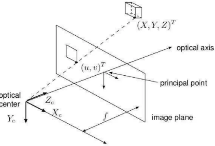
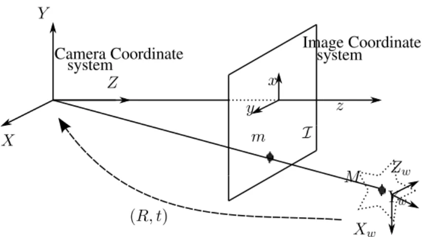
3.2 The camera model . . . 38
3.2.1 Intrinsic parameters . . . 38
3.2.2 Extrinsic parameters . . . 40
3.2.3 Projection equation . . . 41
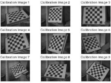
3.3 Calibration . . . 42
3.3.2 Computation of Homography Transform: . . . 43
3.3.3 Computation of the Calibration Matrix: . . . 44
3.4 Stereo Calibration . . . 46
3.4.1 Epipolar geometry . . . 46
3.4.2 Image Rectification . . . 47
3.4.2.1 Calculation of matrix R′ . . . . 48
3.4.2.2 Point to Point correspondance . . . 48
3.4.2.3 Triangulation . . . 49
3.4.2.4 Pose recovery . . . 49
3.5 Spherical Perspective projection . . . 50
3.6 Image Warping: Novel View Synthesis . . . 51
3.6.1 A formal description . . . 51
3.7 Spherical Panorama . . . 52
3.7.1 Novel System Design and Calibration . . . 54
3.7.2 An innovative indoor Spherical RGBD sensor design . . . 57
3.8 Conclusion . . . 59
4 Spherical RGB-D Odometry 63 4.1 Introduction . . . 63
4.2 From 2D Optic Flow to 3D Scene Flow . . . 64
4.2.1 Direct Photometric Registration . . . 66
4.2.1.1 Optimisation Tools . . . 66
4.2.1.2 Efficient Second Order Minimization (ESM) . . . 68
4.2.1.3 Spherical Photometric cost function . . . 69
4.2.2 Rigid Body Motion . . . 71
4.2.3 Weighting Functions . . . 73
4.2.4 Information Selection . . . 74
4.2.5 Multi-Pyramid resolution . . . 76
4.3 Geometric constraint for motion estimation . . . 79
4.3.1 Direct Depth Map Alignment . . . 80
4.3.2 Point to plane registration . . . 83
4.4 Motion Tracking englobing Photo + Geo constraints . . . . 84
4.5 Keyframe-based Representation . . . 86
4.5.1 Median Absolute Deviation . . . 86
4.5.2 Differential Entropy . . . 87
4.6 Evaluation Metrics . . . 88
4.7 Results and Discussion . . . 90
4.7.1 Synthetic dataset: . . . 90
4.7.2 Inria Semir dataset . . . 92
4.7.3 Inria Kahn building dataset (ground floor) . . . 95
4.7.3.1 Metric loop closure . . . 97
4.7.4 Results with Garbejaire Dataset . . . 100
4.8 Conclusion . . . 102
5 Towards Accurate and Consistent Dense 3D Mapping 103 5.1 Introduction . . . 103
5.2 Methodology . . . 103
5.3 A first approach to depth map fusion . . . 104
5.3.1 Depth inconsistency detection . . . 104
5.3.2 Inverse Warping and Depth Map Fusion . . . 106
5.3.3 Results . . . 108
5.3.4 Pose graph optimisation . . . 110
5.4 An improved approach to environment modelling . . . 112
5.4.1 Error modelling and propagation . . . 114
5.4.2 Homogeneous Vector Uncertainty . . . 115
5.4.3 Warped Sphere Uncertainty . . . 115
5.4.3.1 Indoor spherical sensor model . . . .117
5.4.4 Probabilistic data association . . . 118
5.4.5 Features/landmarks visibility scenario . . . 118
5.4.6 Formulation . . . 119
5.4.7 Dynamic points filtering . . . 122
5.4.8 Application to Saliency map . . . 124
5.4.9 Results . . . 125
5.4.10 Discussion . . . 128
6 Conclusion and Perspectives 131
6.1 Conclusion . . . .131
6.2 Perspectives . . . .133
1 Team Presentation . . . ii
2 European Commission projects . . . 3
1.1 European Commission projects . . . 11
2.1 Map representations . . . 23
2.2 Pose/feature graph . . . 25
2.3 Atkinson and Shiffrin human memory model . . . 28
2.4 Long term/ Short term memory model . . . 29
2.5 FSH memory model . . . 31
3.1 Perspective projection . . . 39
3.2 Transformation from image to pixel frame . . . 40
3.3 Transformation from world to camera frame . . . 41
3.4 Calibration with checkerboard pattern . . . 43
3.5 Epipolar Geometry . . . 47
3.6 Image rectification . . . 47
3.7 Spherical perspective projection model . . . 51
3.8 Camera under motion . . . 52
3.9 Acquisition platform with multicamera system . . . 53
3.10 Perspective Image transformation on a sphere . . . 54
3.11 Novel synthesised spherical panoramic image . . . 54
3.12 Spherical RGBD outdoor acquisition system . . . 55
3.13 Augmented RGBD sphere . . . 55
3.14 Spherical Triangulation . . . 56
3.15 Multi RGBD indoor acquisition system . . . 57
3.16 Spherical RGBD construction . . . 57
3.17 spherical panoramic views from indoor multi camera rig . . . 58
3.18 Calibration of non overlapping cameras . . . 60
3.19 Calibration of non overlapping cameras . . . 60
4.4 Application of saliency map . . . 76
4.2 Jacobian decomposition . . . 77
4.3 saliency table . . . 77
4.5 Multi pyramid resolution . . . 79
4.6 Depth map warping . . . 80
4.7 Principle of ICP . . . 83
4.8 Keyframe-based representation . . . 87
4.9 Illustration of Entropy ratio . . . 88
4.10 Synthetic dataset . . . 91
4.11 Trajectory comparison . . . 92
4.12 Performance comparison between cost functions . . . 93
4.13 Snapshots of Inria Semir dataset . . . 94
4.14 Reconstruction using Semir dataset . . . 94
4.15 Performance comparison between cost functions . . . 95
4.17 Reconstruction using Inria Kahn building dataset . . . 95
4.16 Comparison between Keyframe criteria . . . 96
4.18 Snapshots of Inria Kahn building dataset . . . 96
4.19 Pose graph correction . . . 97
4.20 Illustration of loop closure between two nodes . . . 99
4.21 Rotation estimation using an SSD cost function . . . 99
4.22 Reconstruction comparison with metric loop closure . . . .100
4.23 Trajectory reconstruction with Garbejaire dataset . . . .100
4.24 Full trajectory reconstruction . . . .101
5.1 Page-Hinckley Test: events . . . .105
5.2 Page-Hinckley Test: no events . . . .106
5.3 Inverse warping on reference frame . . . .107
5.4 Pipeline using P-H test . . . .108
5.5 Reconstruction comparison with Inria Kahn dataset using2with data fusion 108 5.6 Evualuation of Kahn0 dataset . . . .109
5.7 Trajectories with pose graph optimisation . . . .111
5.8 Results with pose graph optimisation . . . .113
5.10 probabilistic data association . . . 119
5.11 Node comparison pre and post filtering . . . 121
5.12 Filtered depth map evaluation . . . 121
5.13 Sphere segmentation using SLIC . . . 122
5.14 Saliency map skimming . . . 124
5.15 Trajectory comparison with and wihout fusion using error model . . . 125
5.16 Reconstruction comparison with Kahn dataset . . . 126
5.17 Evualuation of Kahn0 dataset . . . 126
Introduction générale
La manière dont les Hommes et les animaux interagissent avec la nature a toujours été fascinante. Cette marche, ce vol ou encore cette navigation dans leur environnement, ou autant de prouesses réalisées sans y réfléchir par le biais des capacités sensorielles respec-tives. Cette aisance inspire la communauté de la recherche en robotique mobile à reproduire de telles capacités au travers d’une certaine forme d’intelligence artificielle. Cette tendance du domaine des robots mobile a permis d’étendre le domaine d’interaction de l’Homme, là où l’interaction directe pour des tâches techniquement éprouvantes est considérée trop risquée ou hors de notre portée physique. Cette extension inclue des tâches aussi diverses que l’exploration de mines abandonnées ou de l’environnement martien, avec les « Mars Rovers » en 2004, jusqu’aux interventions à risques de la centrale nucléaire de Fukushima en 2011 ; toutes ces éminentes missions mettant en exergue les progrès du domaine de la robotique mobile.
Tout robot autonome dont la tâche principale est la navigation est confronté à deux diffi-cultés principales, à savoir la découverte de l’environnement et sa propre localisation. Pour accomplir cette seconde tâche à partir des capteurs équipant ce robot, celui-ci nécessite la connaissance d’une carte de l’environnement. Pour découvrir ou redécouvrir l’environ-nement, et établir ou étendre la carte correspondante, une position précise sur la carte est nécessaire. Depuis deux décades, ces deux problèmes sont devenus la pierre angulaire d’un domaine de recherche connu comme « Simultaneous Localisation and Mapping (SLAM) », soit Cartographie et Positionnement Simultanés. Une carte permet de plus de réaliser des tâches planifiées, en fournissant au robot les informations nécessaires lui permettant, à par-tir d’une position originelle A, de se déplacer jusqu’à une certaine destination B.
Des solutions commerciales de véhicules autonomes sont produites spécifiquement pour la tâche donnée. L’aspirateur Roomba de la société iRobot est équipé d’un ensemble de capteurs basiques adaptés à certaines fonctions spécifiques, comme l’évitement d’obs-tacle, la détection de la présence de saletés au sol, ou encore de capteurs d’inclinaison pour éviter de tomber dans d’éventuels escaliers. Sur les quais industriels, des robots autonomes guidés sont devenus des composants clés des opérations de chargement et déchargement de navires [Durrant-Whyte 1996], induisant une meilleure gestion du trafic sur les quais, une productivité améliorée et des coûts opérationnels réduits. Les opportunités présentées par les véhicules sans conducteurs n’a pas plus laissé l’industrie minière indifférente, avec l’émergence d’une technologie baptisée « Autonomous Haulage System (AHS) » par Rio Tinto (une des principales sociétés du secteur) [AHS 2014]. Ces camions sans composante humaine sont particulièrement adaptés aux conditions difficiles des procédures minières, de part leur activité 24/7 ininterrompue. Les bénéfices rapportés sont colossaux ; de l’ordre de 15–20% d’augmentation de la production, de 10–15% de réduction de la
consomma-tion de carburant, et encore d’un gain de 8% en coût de maintenance. D’un point de vue des ressources humaines, cette technologie a apporté une modification fondamentale des conditions de travail en déplaçant les travailleurs de zones potentiellement dangereuses vers d’autres postes aux risques réduits.
Toutes ces applications qui viennent d’être citées, dédiées à leurs tâches respectives, ne sont fonctionnelles que dans leurs environnements contrôlés propres ; et certaines, par-ticulièrement dans les domaines d’opération industriels, sont de plus dépendantes de l’in-frastructure, avec des espaces de travail hautement contraints et modulaires. Il n’existe malheureusement pas d’application unique disponible pour toute tâche.
La difficulté principale des robots autonomes est sans aucun doute d’opérer au sein d’applications pratiques du monde réel. Il n’est par exemple pas possible de structurer l’environnement sous-marin profond par des infrastructures dédiées dans le but d’explorer la vie sous-marine. Il n’est guère plus envisageable d’un point de vue économique de placer des marqueurs sur l’ensemble de nos réseaux routiers pour aider à la conduite autonome. Aussi, la navigation autonome et la cartographie doivent pouvoir être effectuées à par-tir des seules informations sur l’environnement perçues par le robot. Dans cette optique, le Mobile Robotics Group de l’université d’Oxford [MRG] a établit son motto comme « l’ex-tension à grande échelle de la portée de la navigation autonome, sans requérir de coûteuses, gênantes, et incongrues modifications de l’environnement ». Ils développent au sein d’un consortium réunissant aussi le fabricant de voitures Nissan une plateforme autonome équi-pée de technologies de laser et de vision. L’idée est alors de construire des cartes incluant des informations de situation par rapport à l’environnement statique et dynamique. Cette information sémantique est extraite de l’environnement statique que forment le marquage routier et les feux de signalisation, les informations de direction, ou encore les trottoirs. Ces informations nécessitent toutefois d’être mises à jour à cause des perpétuels changements autour de nous. Pour sa part, l’environnement dynamique consiste aux entités mobiles ou stationnaires telles que les voitures, vélos, piétons, et les autres obstacles. À partir d’une prédiction de comportement, le profil de conduite peut alors être établi en conséquence.
Le Grand Challenge lancé par la « Pentagon’s Defense and Advanced Research Pro-jects Agency » (DARPA) a été le théâtre du franchissement d’un important jalon pour les technologies des véhicules autonomes terrestres (Autonomous Ground Vehicules, AGVs). Lors de ce défi les participants devaient produire un AGV capable de concourir dans une course de 175 miles (282 kms) au travers du désert de Mojave (sud-ouest des États-Unis), et ce dans un temps imparti de 10 heures. Les AGVs participants ont été poussés dans leurs retranchements sur tous types de surfaces : des chemins boueux aux cols montagneux den-telés, en passant par l’éreintant sol désertique. Le groupe de Sebastian Thrun de l’université de Standford a été le grand gagnant de cette compétition à l’aide du robot Stanley. Pour ca-pitaliser cette participation, Professeur Thrun s’est épaulé de Google pour leur ambitieux projet de véhicules robotisés hybrides, dans un consortium réunissant de plus Toyota. En Mai 2011, ce consortium comptabilisait [Gca 2011] 140K miles (225000 kms) de kilomé-trage cumulé de leurs six Toyota Prius autonomes et unique Audi TT parcourus sur les
routes de Californie, dont plus de 1000 miles (1500 kms) en complète autonomie. La tech-nologie utilisée est perçue comme améliorant l’efficacité énergétique tout en réduisant les accidents et morts sur les routes.
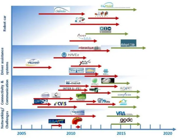
FIG. 2: Vue d’ensemble des projets financés destinés au développement de la navigation autonome.
Cette étude a été realisée pendant les dix dernieres années. Les flèches en rouges représentent des projets complétés et celles en vertes , les projets en cours (source : The European Technology Platform on Smart Systems Integration- EPoSS [EPo])
Du côté Européen, de nombreux projets ont vu le jour dans des applications de voitures intelligentes et d’urbanisme. Un de ces projets des plus avancés est CityMobil2, successeur de CityMobil. Ce projet implique un système de transport routier public automatisé local appelé Cybernetic Transport System (CTS), qui agirait à la demande sur le même principe qu’un ascenseur. Son but serait de compléter les transports publics existants pour les cas de faible influence ou dessertes éloignées, offrant un service efficace et plaisant aux usagers routiers. Ces cyber-voitures pourraient alors rouler dans des zones particulières telles que les zones piétonnes, les parkings et sites privés tels que les hôpitaux, ou encore les voies de bus libres. Une première phase de test a été menée dans la ville de La Rochelle en France. Le projet V-Charge [VCh] quant à lui, devrait apporter des solutions aux évolutions supposées des transports publics et personnels des années à venir. Leurs infrastructures incluent une aide à la conduite dans les environnements urbains, ou des options telles que la
conduite autonome dans certaines zones (stationnement automatisé, parc-relai). Une plate-forme (semi-) robotique utilisant des capteurs ultrasoniques, de signal GPS, et caméra, a été conçue au sein de ce projet, comme un élément de cette contribution majeure. La figure 1.1 présente une liste exhaustive des projets financés par la commission européenne depuis 2005, terminés ou en cours.
Bien que le progrès technologique est permanent, avec plusieurs des projets prêt à être commercialisés, le plus gros obstacle à ce point de développement en devient le cadre lé-gislatif. Les incroyables avancées technologiques menacent de dépasser les lois existantes sur la mobilité et le transport, certaines desquelles datent de l’époque des carrioles à che-vaux.Ainsi, pour que la conduite autonome prenne son essor comme une incontournable réalité dans un futur proche, les décideurs doivent rapidement réagir pour anticiper un fonc-tionnement cohérent de ces cyber-voitures.
Inscription de cette thèse dans le cadre présenté
Notre attention se concentre sur l’élaboration de cartes topographiques égo-centrées représentées par un graphe d’images-clés qui peuvent ensuite être utilisées efficacement par des agents autonomes. Ces images-clés constituant les nœuds de cette arborescence combinent une image sphérique et une carte de profondeur (couple que l’on appelle sphère de vision augmentée), synthétisant l’information collectée sur l’environnement immédiat par un système de capteurs embarqués. La représentation de l’environnement global est obtenue par un ensemble de sphères de vision augmentées, apportant la couverture néces-saire de la zone opérationnelle. Un graphe de « pose » liant ces sphères les unes aux autres dans un espace de dimension six définit le domaine potentiellement exploitable pour la navigation en temps réel. Nous proposons dans le cadre de cette thèse une approche de la représentation basée sur les cartes en considérant les points suivants :
– L’application robuste de l’odométrie visuelle, tirant le meilleur parti des données de photométrie et de géométrie disponibles par notre base de données des sphères de vision augmentée
– La détermination de la quantité et du placement optimal de ces sphères augmentées pour décrire complètement un certain environnement
– La modélisation des erreurs de mesure et la mise à jour des données compactes des sphères augmentées
– La représentation compacte de l’information contenue dans les sphères augmentées pour s’assurer de la robustesse, la précision et la stabilité le long d’une trajectoire, en exploitant les cartes d’intérêt
Cette recherche met à profit et étend les résultats du projet à succès CityVip présentés dans [Meilland et al. 2010,Meilland et al. 2011a,Meilland et al. 2011b], de part plusieurs aspects. Dans l’optique d’améliorer l’odométrie visuelle, une fonction de coût est intro-duite, combinant autant les contraintes géométriques que photométriques s’appliquant sur
la capture directe de l’image pour l’estimation de la pose. De plus le problème de l’opti-misation du graphe de pose est abordé par laquelle à partir d’une base de sphères visuelles augmentées, une trajectoire explorée aux données redondantes est extraite pour former un graphe de pose squelettique épuré.
Cartographier sous l’hypothèse d’un environnement statique est sous un certain as-pect sans intérêt, puisque l’environnement dans lequel le robot évolue nominalement est dynamique et évolue de manière imprédictible. Bien que certaines parties du milieu sont statiques en considérant un intervalle de temps court, d’autres sont susceptibles de changer abruptement selon les activités se déroulant tout autour du robot, comme des piétons en n’importe quel point voisin et les voitures sur la route. Cet aspect est couvert dans notre travail par l’introduction du concept des entités dynamiques qui évoluent selon une tra-jectoire. En plus du graphe initial des sphères de vision augmentée, comprenant les cartes photométrique, géométrique, et saillance, deux composants supplémentaires sont mainte-nant liés aux contenus d’information sur l’environnement de notre graphe ; à savoir la carte d’incertitude et la carte de stabilité.
Organisation du document
Le chapitre 2 établit l’état de l’art des systèmes de SLAM uniquement basés sur la
vi-sion. Les écueils d’autres technologies de capteurs comme le GPS, les encodeurs des axes des roues, ou encore des scanners laser, ont poussé les chercheurs à exploiter l’horizon des possibilités offertes par les contenus riches des images. L’historique du développement de l’odométrie visuelle (VO) montre que les efforts initiaux portaient tout particulièrement sur la construction de robots mobiles robustes destinés à l’exploration planétaire. Ensuite vinrent les applications de véhicules terrestres, aériens, et sous-marins intelligents, diver-sifiant ces techniques d’odométrie visuelle. Un autre domaine très prometteur requérant la VO est celui de la réalité augmentée. Tout comme d’autre techniques d’odométrie, la VO est sujette au problème de dérives. Dans la littérature, la VO est décrite par deux approches différentes : une approche par entité d’intérêt, et une approche par densité. Les avantages et inconvénients des deux techniques sont soulignés ; des exemples tirés de la littérature sont détaillés pour mettre en exergue la place de la VO dans le cadre du SLAM. Dans un but de positionnement, un robot requiert normalement une carte de son environnement perçu. Cette carte peut être établie au fil de la phase d’exploration, ou séparément au cours d’une phase d’apprentissage initiale d’exploration pure. Dans ce contexte, la cartographie est constituée de plusieurs couches : topologie métrique, sémantique. Les avantages et incon-vénients de ces couches sont ensuite élaborés plus avant. Enfin, un mot doit être dit sur le domaine naissant des cartes permanentes. Cette approche cherche à équiper des véhicules intelligents de nouveaux outils pour appréhender les défis de l’exploration à grande échelle s’appuyant sur des ressources telles que la capacité de stockage, de puissance de calcul, ou de navigation complètement autonome et non-supervisée, limitées. Malgré ces limitations, le robot doit avoir la capacité de créer une carte stable, qui peut alors être réutilisée autant de fois qu’elle est nécessaire sur de longues périodes de temps.
Le chapitre 3 introduit le lecteur au monde de la vision 3D dans la première partie. Dans
le but d’illustrer le processus complet de formation de l’image sur l’optique de la caméra, une application directe de calibration de caméra est discutée. Pour ensuite extrapoler les informations 3D comme perçues par la vision humaine à partir des images 2D, le concept de vision stéréo est mis en avant en décrivant l’ensemble des phases intermédiaires jusqu’à l’obtention des informations de profondeur. Cette synthèse concise de géométrie projec-tive et de vision stéréo permet d’établir certains concepts de base qui seront utilisés par la suite dans la deuxième partie du chapitre où la vision sphérique est introduite. On établit l’intérêt de la représentation par vision sphérique et ses multiples avantages, c’est à dire un modèle enrichi compact de l’environnement, avec une représentation par champ de vision (Field of View, FOV) omnidirectionnel à 3600 et invariant par rotation, ce qui rend cette
représentation imperméable aux différentes configurations de capteurs. De plus, couvrir l’environnement exploré sur le plus grand intervalle possible et d’orientations possibles, conduit à une meilleure localisation. Ces avantages ont motivé les chercheurs à élaborer des technologies innovantes telles que les caméras catadioptriques, ou encore mieux, les systèmes de caméras multi-trames. Tandis que ces premiers systèmes permettent d’obtenir immédiatement des images sphériques, l’obtention d’un panorama sphérique avec les se-conds n’est pas direct. Cette difficulté requiert des opérations intermédiaires sur les images, telles que déformation, fusion, et composition. Dans ce chapitre, une vue d’ensemble de ces techniques est donnée, avec des applications aux milieux en intérieur et en extérieur des systèmes multi-capteurs développés dans le cadre des activités de recherche de l’équipe. Pour chaque système, la technique de calibration propre est surimposée, produisant les matrices extrinsèques des systèmes multi-caméra. Cette étape est essentielle pour la pro-duction de panorama sphériques virtuels rendant la vue équivalente à ce qui devrait être vu.
Le chapitre 4 discute de l’odométrie RGB-D sphérique. On commencera par une
des-cription compréhensive du modèle du flux optique, extrapolé en un flux scénique 3D pour l’application directe à l’estimation de mouvement. Ce concept des plus importants struc-ture de la technique Lucas-Kanade traitant de la détection directe basé sur les images, laquelle calcule un mouvement paramétré relativement inconnu entre deux images, pour un déplacement relativement faible entre les deux images. Un aperçu de la fonction de coût photométrique est produit en appliquant celle-ci à notre ensemble de sphères visuelles augmentées, lesquelles consistent en images sphériques RGB et cartes de profondeur et d’intérêt correspondantes. Les techniques basées sur l’intensité montrent leurs limitations dans des environnements soit mal éclairés, soit sujets à de grandes variations de luminosité. Pour compenser les manquements de ces méthodes, une seconde fonction de coût est in-troduite, prenant en compte explicitement le contenu géométrique des cartes de profondeur par l’implémentation d’une technique itérative du point le plus proche (Iterative Closest Point, ICP) d’un plan, dont l’inspiration provient de la littérature. La minimisation hybride de ces deux fonctions de coût conduit à une formulation améliorée incluant autant des in-formations géométriques que photométriques. L’environnement global est représenté par
un graphe de pose constitué de nœuds et d’arêtes, et établit par la VO sphérique ; chaque nœud est représenté par une image-clé. La sélection de ces images-clés est primordiale dans une telle représentation, puisqu’une sélection avisée résulte en plusieurs avantages. Tout d’abord, le redondance des données est minimisée, minimisation impliquant une re-présentation plus compacte et clairsemée. Ces deux propriétés sont des plus recherchées dans le cadre de l’exploration d’un environnement de grande échelle et avec une capacité limitée. Ensuite, l’utilisation d’un nombre réduit d’images-clés facilite la réduction de l’in-tégration des erreurs de dérive inhérentes à l’odométrie d’image à image-clé. Dans la même optique, deux autres critères notables sont considérés, la Déviation Absolue Médiane (Me-dian Absolute Deviation, MAD) et un second utilisant la différence d’entropie, laquelle est une image de de l’incertitude de la pose. Pour valider les différents aspects discutés dans le chapitre, une partie « résultats » dédiée détaille quatre cas : deux ensembles de données simulées et deux ensembles de données réelles. Les avantages et limites de l’algorithme sont ensuite discutées avant de conclure. L’évaluation expérimentale de ce chapitre a été en partie présentée dans une conférence internationale [Gokhool et al. 2014] et une seconde, nationale [Rives et al. 2014].
Le chapitre 5 aborde les diverses limites précédemment établies ; notamment les
pro-blèmes de dérive ou de perte de l’odométrie qui casse alors la cohérence globale de la représentation par graphe de pose/d’intérêt. Une première approche cherche à améliorer la carte de profondeur, au profil très bruité résultant du capteur. Pour pouvoir fusionner les mesures de la carte de profondeur, celles-ci doivent être représentées dans un réfé-rentiel commun. Les observations obtenues le long d’une trajectoire sont obtenues dans ce référentiel particulier par transformation inverse. Pour détecter les incohérences dues à des problèmes d’occultation ou de bruit entre les cartes de profondeur mesurée et ob-servée, un test statistique est ajouté à l’implémentation. Ce test consiste principalement à la détection de la dérive sur la base des séries de temps moyennes d’un signal discret. L’intérêt limité de cette méthode lors de sa première évaluation a conduit à considérer une seconde, prenant en compte les erreurs aléatoires et dynamiques des capteurs. Un modèle d’incertitudes bien meilleur est formulé en prenant en compte autant la conception de notre représentation sphérique que les incertitudes de l’opération de transformation. Une tech-nique d’association de données probabiliste est conçue pour identifier les points aberrants dus aux phénomènes de bruit, occultations, et violation de l’espace libre. Les valeurs ob-servées correspondant aux mesures sont fusionnées pour améliorer le contenu géométrique et photométrique des sphères augmentées. Le cas des points dynamiques est de plus traité, conduisant ainsi à création d’une nouvelle entité dans notre ensemble de de sphères aug-mentées, la carte de stabilité. Cet attribut supplémentaire est utilisé pour mettre à jour la carte d’intérêt. Une partie expérimentale évalue cette seconde approche, avant de conclure. La formulation et l’évaluation expérimentale correspondante ont été en partie présentée dans une conférence internationale [Gokhool et al. 2015].
Le chapitre 6 résume l’évaluation de ce travail et des perspectives sont établies et
discu-tées pour permettre de d’amener ce projet de cartographie encore plus loin en utilisant de plus le cadre VSLAM sous-jacent.
Contributions
Internationale :
– T. Gokhool, R. Martins, P. Rives and N. Despré. A Compact Spherical RGBD
Keyframe-based Representation. In International Conference on Robotics and
Au-tomation, (ICRA), Seattle, Etats Unis, May 2015.
– T. Gokhool, M. Meilland, P. Rives and E. Fernàndez-Moral. A Dense map Building
Approach from Spherical RGBD Images. In International Conference on Computer
Vision Theory and Applications, (VISAPP), Lisbon, Portugal, January 2014. Nationale :
– P. Rives, R. Drouilly and T. Gokhool. Représentation orientée navigation
d’envi-ronnements à grande échelle.Reconnaissance de Formes et Intelligence Artificielle,
Preamble
1.1 Introduction
We have always been captivated in the way humans and animals interact with nature. The way they effortlessly walk, fly or navigate in the environment using their sensing prowess. We have indeed been inspired to replicate the sort of capabilities in robots by fitting them with the kind of artificial intelligence. Having said so, the field of mobile robotics has extended our reach to areas where human investigation is considered too risky or beyond our physical means as the tasks presented are too technically challenging. Applications ranging from exploration of abandoned mines, to planetary missions of Mars Rovers in 2004, to hazardous interventions in the Fukushima nuclear plant in 2011, all these valuable missions epitomises the progress made in the area of mobile robotics.
The core challenge for any autonomous robot whose main task is navigation is com-posed of two characteristic problems; environment mapping and localisation. To be able to locate itself by using onboard sensors, the robot requires a map. Parallely, to be able to up-grade or to extend the map, precise location on the map is required. Since two decades,these two problems have become the cornerstone of a research field known as Simultaneous
Lo-calisation and Mapping(SLAM). A map further bolsters trajectory planning tasks by
pro-viding the robot with the required information to drive from source place A to destination B.
Commercial autonomous vehicle solutions are tailormade accordingly to the task at hand. The Roomba vacuum cleaner of iRobot is equipped with a set of basic sensors cur-tailed for specific functions, such as obstacle avoidance, detection of dirts on the floor, steep sensing to prevent falling off down stairs. In cargo handling terminals, autonomous guided vehicles have been a key component in ship loading and unloading [Durrant-Whyte 1996], leading to more efficient traffic management in cargo terminals, increased productivity and reduced operating costs. The wonders of driverless vehicles have not left the mining in-dustry indifferent with the emergence of a technology baptised as Autonomous Haulage System (AHS) by Rio Tinto (a leading company in the business) [AHS 2014]. These un-manned trucks adapt well to the rigorous mining procedures, providing an incessant 24/7 service round the clock. Reported benefits are huge; 15 − 20 percent increase in output, 10− 15 percent decrease in fuel consumption, 8 percent gain in maintenance cost. On
the workforce plan, this has led to a shift in manpower requirements by removing workers from potentially hazardous environments to new employment opportunities with reduced
labour intensive operations.
The above-mentioned task specific applications are functional in controlled environ-ments and some of these solutions, especially those operating in the industry are infras-tructure dependent with constrained and highly manageable workspaces. Unfortunately, there does not exist a single off-shelf application for all applications. Undoubtedly, the most challenging task for autonomous robots is to operate in practical real world appli-cations. It is not feasible to fix dedicated infrastructures for deep sub-sea navigation for the exploration of marine life for example. It is economically not viable to place artificial markers along our road networks to facilitate autonomous driving. Therefore, autonomous navigation and mapping should be done by relying solely on the environment that the robot perceives. In this context, the Mobile Robotics Group at Oxford University [MRG] aims at “extending the reach of autonomous navigation to vast scales without the need of
ex-pensive, awkward and inconvenient modification of the environment”. In consortium with
Nissan car manufacturer, an autonomous platform is developed with laser and vision tech-nology. The idea is to build maps incorporating situational awareness with respect to static and dynamic environments. Semantic information is extracted from static environments such as road marking, traffic lights, lane information, curbs. These information however, needs updating over time due to the constant nature of changes around us. Dynamic infor-mation integrates moving or stationary entities such as cars, bicycles, pedestrians, obsta-cles. Based on their predictive behaviour, the driving profile can be moulded accordingly.
The Grand Challenge launched by Pentagon’s Defense and Advanced Research Projects Agency (DARPA) saw a great milestone laid out in autonomous ground vehicles (AGV)s. Participants were required to come up with AGVs to compete in a race track of 175 miles in the Mojave desert (south west US) within a limited time frame of 10 hours. The depth and breadth of AGVs were severely put to test on all types of surfaces; from dirt roads to rugged mountaineous passages, not to forget the sluggish nature of the desert. Sebastian Thrun’s group at Stanford University emerged out as big winners for this com-petitions thanks to the robot Stanley. To take forward this fruitful experience, Professor Thrun recently joined hands with Google for their ambitious robotic hybrid vehicle project (in consortium with Toyota). It was reported that, as at May 2011 [Gca 2011] the registered mileage of Google’s six fleet of six autonomous Toyota Priuses and one Audi TT stood at 140K miles on the roads of California, with more than 1000 miles performed on fully autonomous mode. The implemented technology is hyped to increase energy efficiency whilst reducing road injuries and deaths rates in the future.
On the European level, many projects have seen the lights too with applications in cybercars and urban technology. CityMobil2, an offspring of CityMobil is now well under way. In this project, a local public automated road transportation system, baptised as CTS-Cybernetic Transport System, works on demand with the same principle of operation of an elevator. The purpose is to complement public mass transportation systems when demand is low or pick-up points are far apart providing a more effective and pleasant service to road users. These cybercars will be allowed to run in dedicated areas such as pedestrian
Figure 1.1: An overview of funded projects that support the development of automated driving. The
analysis has been done for the period of the last ten years. Red arrows correspond to completed projects and green arrows relate to ongoing projects (source: The European Technology Platform on Smart Systems Integration- EPoSS [EPo])
areas, car parks, private sites such as hospitals or dedicated bus lanes when unoccupied. An initial testing phase has been conducted in the city of La Rochelle in France.
The V-Charge project [VCh], too is envisioned on providing solutions for anticipated changes in public and individual transportation in the years to come. The facilities include: advanced driver support in urban environments, options such as autonomous driving in designated areas (e.g. valet parking, park and ride) will also be offered. As part of this key contribution, a (semi) robotic platform has been conceived by using cost GPS, camera and ultrasonic sensors. Figure1.1summarises a long exhaustive list of completed and ongoing projects funded by the European Commission (EC) since 2005.
While progress of technology is steadfast with several projects ready to go on the mar-ket, the biggest hurdle somehow at this point lies within the main regulatory framework and the legislation bodies. The stupendous advancement of technology foresees the dan-ger of outstripping existing laws on mobility and transportation, with some of them dating back to the era of horse-drawn carriages. Therefore, if autonomous driving is to become an
unavoidable reality in the near future, policy makers should react quickly to anticipate the good functioning of this generation of cybercars.
1.2 This Thesis
Our aim is concentrated around building ego-centric topometric maps represented as a graph of keyframe nodes which can be efficiently used by autonomous agents. The keyframe nodes which combines a spherical image and a depth map (augmented visual sphere) synthesises information collected in a local area of space by an embedded acqui-sition system. The representation of the global environment consists of a collection of augmented visual spheres that provide the necessary coverage of an operational area. A "pose" graph that links these spheres together in six degrees of freedom, also defines the domain potentially exploitable for navigation tasks in real time. As part of this research, an approach to map-based representation has been proposed by considering the following issues:
• How to robustly apply visual odometry by making the most of both photometric and geometric information available from our augmented spherical database
• How to determine the quantity and optimal placement of these augmented spheres to cover an environment completely
• How to model sensor uncertainties and update the dense information of the aug-mented spheres
• How to compactly represent the information contained in the augmented sphere to ensure robustness, accuracy and stability along the trajectory by making use of saliency maps
This research work builds on the back of the successful CityVip project and extends the results presented in [Meilland et al. 2010], [Meilland et al. 2011a], [Meilland et al. 2011b] in several ways. With the aim of robustifying Visual Odometry, a cost function is intro-duced combining both geometric and photometric constraints applied in a direct image registration framework for pose estimation. Additionally, the problem of pose graph opti-mization is addressed, whereby, given a database of augmented visual spheres, an explored trajectory with redundant information is pruned out to a sparse skeletal pose graph.
Mapping under the assumption that the environment is static is somewhat baseless since the environment under which the robot is normally deployed is dynamic and evolves in unpredictable ways. Though some parts of the surrounding are static in the short run, others may be changing abruptly due to activities occurring around the robot– people walking around, cars on the road. This aspect is treated in our work by introducing the notion of dynamic entities which evolve along a trajectory. In addition to the initial graph of augmented spheres comprising of the photometric, geometric and the saliency map, two
more components are now tethered to the environment information content of our graph; the uncertainty map and the stability map.
1.2.1 Manuscript organisation
Chapter 2 lays down the state of the art of vision only slam systems. Limitations of
other sensing technologies such as the GPS, wheel encoders, laser range scanners have broaden the horizon of researchers by exploiting the rich contents of images. The histori-cal roadmap of visual odometry (VO) showed that initial efforts were concentrated towards building robust mobile robots for planetary explorations. Later on, visual odometry tech-niques became more diversified with applications to terrestial, aerial, sub-sea intelligent vehicles. Augmented reality is another promising area which requires VO. VO as other odometry techniques is not spared by the problem of drift. Two different approaches exist in literature; feature-based and dense-based. Both techniques are highlighted with their benefits and inconveniences. Further examples are detailed from literature to show how VO fits the SLAM framework. For localisation purposes, a robot normally requires a built map of its perceived environment. This can be done on the fly during the exploration phase or a map representation can be constructed separate from the exploration task during a first learning phase. In this context, the mapping framework is made up of several layers; met-ric topological, semantic. The pros and cons of each one of them is elaborated. Finally, the emerging field of lifelong mapping is worth a mention. This area aims at equipping intelligent vehicles with new tools to tackle the challenges of vast scale exploration with limited resources such as memory capacity, computational power or fully autonomous un-supervised navigation. Moreover, the robot should have the ability to create a stable map which can be used over and over again for long periods of time.
Chapter 3 introduces the reader to the world of 3D Vision. In order to illustrate the
whole process of image formation onto the camera frame, a direct application involving camera calibration is discussed. To further extrapolate 2D images to 3D information as perceived by human vision, the concept of stereo vision is outlined, describing all the in-termediary stages until the depth information extraction. These introductory concepts are vital to understand the extension to spherical vision, developed in the second fold. The motivation sparks from the multitude advantages it offers; a compact but enriched envi-ronment model with 3600 omnidirectional field of view (FOV) representation as well as
its invariance to rotation making it indifferent to sensor configuration. Moreover, cover-ing the explored environment with the maximum possible range and orientation leads to better localisation. These aspects have encouraged researchers to come up with innovative ideas such as catadioptric cameras or better, multi baseline camera systems. While in the former case, a spherical image is readily obtained, for the latter case, obtaining spherical panoramas are not straightforward. This requires intermediary operations on images such as warping, blending and mosaicing. In this chapter, an overview of these techniques is pro-vided with application to indoor and outdoor multi sensor systems developed as part of the
research activities of our team. For each system, its corresponding calibration technique is overlaid which outputs the extrinsic parameter matrices for the multi camera system. This step is vital for producing synthesised spherical panoramic images as it shall be seen.
Chapter 4 is based on spherical RGB-D odometry. It begins with an understanding of
the optical flow model and extrapolated to 3D scene flow as a direct application to motion estimation. This important concept forms the backbone of the Lucas-Kanade’s direct im-age based registration technique where a relative unknown parametrised motion between two image frames with small interframe displacement is computed. An overview of the photometric cost function is function is given as applied to our set of spherical augmented spheres consisting of spherical RGB images and their corresponding depth and saliency maps. Intensity based techniques show their limitations in poorly textured areas or regions subjected to high illumination variations. To compensate the weakness of such methods, a second cost function is introduced where the geometric information content of the depth map is explicitly taken into account with the implementation of a point to plane iterative closest point (ICP) technique inspired from literature. This leads to an improved formula-tion incorporating both geometric and photometric informaformula-tion in a hybrid minimizaformula-tion cost function. The global environment is represented by a pose graph consisting of nodes and edges, established from spherical VO, whereby each node is represented by a keyframe. Keyframe selection is a vital task in such a representation as careful selection of frames re-sults in several advantages. Firstly, data redundancy is minimised, hence rendering the representation sparser and more compact. These are highly desirable properties when ex-ploring vast scale environments with limited capacity. Secondly, using less keyframes helps in reducing the integration of tracking drift errors emerging from frame to keyframe odom-etry. Along this line, two different criteria are considered, notably, the median absolute deviation (MAD) and the other based on differential entropy which is an abstraction of the pose uncertainty. To validate the several aspects discussed in this chapter, a results section elaborates on two synthetic and two real datasets. The strengths and weaknesses of the algorithm are exploited before the conclusion is wrapped up. The experimental evaluation of this chapter was partly published in one international [Gokhool et al. 2014] and one national [Rives et al. 2014] conferences.
Chapter 5 tackles the various shortcomings exposed in the previous chapter, notably,
the problem of drift or odometry failures which disrupts the global consistency of our pose/feature graph representation. A first approach seeks to improve the noisy depth map output from the sensor. In order to fuse depth map measurements, they should be rep-resented in a common reference frame. Observations acquired along the trajectory are transferred to that particular frame by an inverse warping transformation. To detect in-consistencies arising due to occlusion phenomena or noise between the measured and the observed depth maps, a statistical test is implemented. The latter is principally based on drift detection on the mean time series of discrete signal. The limitations perceived during the evaluation of this first approach led to the consideration of a second methodology which
takes into account random and dynamic errors coming from the sensor. A much improved uncertainty model is formulated considering both the design of our spherical representa-tion coupled with uncertainties coming from the warping operarepresenta-tion. A probabilistic data association technique is devised in order to detect outliers coming from noise, occlusion, disocclusion and free space violation phenomena. Observation values in agreement with the measurement are fused so as to improve the geometric and photometric content of the augmented spheres. The aspect of dynamic points are further treated leading to the emer-gence of a new entity in our set of augmented spheres which is the stability map. This additional attribute is used to update the saliency map. An experimental section evaluates this second approach before the chapter is concluded. Part of the conceptual formulation and experimental evaluations of this chapter has been published in [Gokhool et al. 2015].
Chapter 6 summarises the evaluation of this work and perspectives are discussed to give
an idea of how to take this mapping project to the next level by further exploiting the underlying VSLAM framework.
1.2.2 Publications
International:
• T. Gokhool, R. Martins, P. Rives and N. Despré. A Compact Spherical RGBD
Keyframe-based Representation. In International Conference on Robotics and
Au-tomation, (ICRA), Seattle, US, May 2015.
• T. Gokhool, M. Meilland, P. Rives and E. Fernàndez-Moral. A Dense map Building
Approach from Spherical RGBD Images. In International Conference on Computer
Vision Theory and Applications, (VISAPP), Lisbon, Portugal, January 2014. National:
• P. Rives, R. Drouilly and T. Gokhool. Représentation orientée navigation d’environnements à grande échelle. Reconnaissance de Formes et Intelligence
State of the Art
2.1 Introduction
Visual Odometry (VO) is defined as the process of estimating the relative motion of a mobile agent using vision sensors. This incremental technique computes the pose of a ve-hicle based on the movements induced by onboard cameras. Over the years, VO has been useful to compensate other similar techniques such as wheel odometry which is highly af-fected by dead reckoning in uneven terrains. On the other hand, global positioning system (GPS) has shown its limitation in aerial, underwater applications. In urban canyons type of environment, multiple reflections of GPS signals from skyscrapers’ façades provide in-accurate measurements. As of late, breathtaking advancements in both vision sensors and computing hardware have made computer vision algorithms more mature down the years. Consequently, efficient, low cost odometry solutions provided by vision systems have seen widespread applications in the field of mobile robotics.
This chapter provides a broad coverage of the approaches and methodologies involved in equipping mobile robots with vision technology, starting from the theory of VO, through intelligent modelling of the environment before ending on the techniques for lifelong au-tonomous deployments.
2.2 VO & SLAM
Historical roadmap The first footprint of egomotion estimation applied to mobile robots
appeared in the early 80s with the work of [Moravec 1980]. The efforts in this era were particularly motivated around the conception of planetary rovers and provide them with the ability to measure their six degree of freedom motion in unstructured rugged terrains where wheel odometry is highly unreliable, notably due to wheel skidding. In this work, a single camera was made to slide on a stop and go motion style, digitizing and analyzing images at every location. This approach termed as slider stereo computed the rigid body motion by aligning 3-D points perceived between two consecutive frames. Between each stop, the camera slid horizontally on the rail, taking 9 snapshots at known equidistant intervals. A novel corner-based feature extraction technique was used to extract image primitives in a reference frame which was matched along the epipolar line of the 8 others using normalised
cross correlation as similarity criteria. Outliers were removed using a coarse to fine strategy accounting for large scale changes and the system was solved in a weighted least means square fashion to obtain the relative pose.
Although a single camera was used, this work belongs to the category of stereo VO simply because 3D positions are directly measured by triangulation, as do trinocular meth-ods as well. One typical drawback is that motion can only be recovered up to a scale factor. The absolute scale can then be determined using motion constraints or from measurements obtained by using additional sensors such as IMUs and range sensors. Even then, monoc-ular methods attracts particmonoc-ular interest since VO degenerates into monocmonoc-ular for the case where the distance to the scene is much larger than the stereo baseline as pointed out in [Scaramuzza & Fraundorfer 2011].
Since then, the framework of [Moravec 1980] has been adopted as a guideline for further improvements. The binocular system of [Matthies 1980] incorporated feature un-certainties in the pose estimation phase, which even saw better results in terms of relative trajectory error obtained. Later on, along the same streamline of developping planetary mobile robots equipped with VO technology, [Lacroix et al. 1999] focussed on good pixels to track. Reliable pixels are those whose corresponding 3D point are accurately known based on a stereo vision error model. Additionally, Pixel selection is further enhanced by studying the behaviour of key pixels around their neighbourhood. Interestingly, the corre-lation score curve extracted around that key pixel was found to have a strong recorre-lationship with disparity uncertainty – the sharper the peak observed, the more precise is the dispar-ity. The neighbourhood pixel information was further used to discard points which may drift over subsequent frames due to false correspondences occurring in low textured areas. Pixel tracking between a stereo frame T0and T1 is done by finding correspondences in the
search zone of image frame T1predicted by an estimated transformation uncertainty. This
prediction is important to restrict the search zone thereby increasing the chance of finding an inlier, or better, rejecting an outlier match. Ultimately, egomotion estimation is com-puted based on a 3D–3D constrained weighted least square approach proposed in [Haralick
et al.1989]. However, using wheel odometry feedback for an initial pose estimation is not
always reliable. How the problem of slippage was tackled was not discussed by the author. The conceptual analysis made in [Lacroix et al. 1999] was later implemented on the Mars rover platform later published in the work of [Cheng et al. 2006]. The only difference is that motion computation is encapsulated in a Random Sample Consensus, RANSAC mechanism [Fischler & Bolles 1981]. RANSAC is an established model fitting paradigm to perform parameter estimation taking into account noisy data. Given two initial sets of data points randomly sampled, one pertaining to the source and the other, to the destination set, the objective is to obtain the best model parameters. For the case of VO, the hypothesized model is the relative motion (R, t) between two camera frames and data points extracted from these two sets are then candidates for feature correspondences.
The term Visual Odometry was epitomised in the landmark paper of [Nistér et al. 2004] though research in this field has been ongoing for the last two decades or so, leading to his
real time VO algorithm. Feature detection was based on a Harris corner implementation of [Harris & Stephens 1988] using an optimal number of operations leaning on MMX coding instructions. Robust motion estimation is computed using in an iterative refinement fashion using a preemptive RANSAC [Nistér 2003], a variant of the original algorithm. To validate the method, a mobile robotic platform was integrated with the VO component. The vehicle was also equipped with a Differential GPS, (DGPS) as well as a high precision
Inertial Navigation System (INS). The highly accurate INS/DGPS system was used only
as a comparative ground truth. The mining-like truck vehicle was made to navigate in rough agricultural and forestial environments. Results obtained were impressive, with a positional error as small as 1.07% with respect to the DGPS and an almost negligible orientation error as of around 0.60 with respect to the INS on a track of around 600m. This
work is considered as a genuine VO breakthrough for autonomous ground vehicles.
2.2.1 Feature based vs Dense based
Odometry techniques in general require accurate relative motion estimation to reduce tra-jectory drift. VO, which relies heavily on image contents requires at first hand good quality feature matching which makes the problem difficult [Fitzgibon 2003]. An important step prior to registration requires that data coming from two viewpoints should be put in corre-spondence. Two main approaches are identified; one which goes through an initial feature identification phase between the two data samples while the other uses dense correspon-dence technique.
Feature based This approach is aimed at extracting salient points in an image which are
most likely to find a good match in other images. For example, a blob is an image feature whose characteristics such as intensity, colour and texture differ distinctively from its im-mediate surrounding. On the other hand, a corner is a point occurring at the intersection of two or more edges. Good features to track must generally possess specific properties such as invariance to illumination, rotation, scale or perspective distortion. They must be robust to noise, compression artifacts or blur. They should be easily redetected in other images, thus repeatable. They must provide accurate localisation both in position and scale and finally, they must be notably distinct so that correspondences can be found in other images, especially, those covering the same ground at two different vantage points. In quest of finding features with the above mentioned properties, a great deal of effort has been input by the research community. Popular feature detectors are Harris [Harris & Stephens 1988], Shi-Tomasi [Tomasi & Shi 1994], FAST [Rosten & Drummond 2006], SIFT [Lowe 2003], SURF [Bay et al. 2006], BRISK [Leutenegger et al. 2011], ORB [Rublee et al. 2011] to name a few. An indepth analysis of each one of them is provided in [Fraundorfer & Scaramuzza 2012].
Similarity measures such as the sum of squared differences (SSD), sum of absolute
criteria used to evaluate matches across images. Feature matching techniques can be further subdivided in two further approaches. In the first, extracted features from the first image is matched across subsequent frames using local search techniques based on correlation as discussed above. This works well for close sequential images in a video for example. In the second approach, two sets of features are extracted in two images located at different viewpoints and are then matched for correspondences. This is more suited for wide baseline camera frames where images are taken from two completely different viewpoints resulting in a direct application where large scale environments are involved. Such techniques help to overcome motion drift related issues.
Feature based techniques are frequently used for egomotion estimation since they pro-vide a compact information content as compared to using all the image pixels. However, they rely on an intermediary estimation process based on detection thresholds. This pro-cess is often ill-conditioned, noisy and not robust thereby relying on higher level robust estimation techniques as pointed out in [Meilland & Comport 2013b].
Dense based Also known as direct method, this technique does not require
preprocess-ing of 2D points for matchpreprocess-ing. Instead, the entire content of a source image I∗ and a
destination image I are used to compute the camera motion in a direct intensity min-imisation approach embedding a parametrised motion. Indeed, this minmin-imisation func-tion is non linear, which requires solvers provided by Gradient Descent, Gaussi- Newton or Levenberg-Marquardt class of optimisation tools. This technique works well for very small interframe incremental motions but due to the fact that the whole image information content is used, the minimisation approach takes advantage of the massive data redun-dancy to output a more robust and precise pose estimate. Initially proposed by [Lucas & Kanade 1981], several variants later appeared in literature improving the original al-gorithm in terms of computational cost and robustness [Baker & Matthews 2001] , while [Malis 2004] later provided an even better conceptualisation of the method based on a sec-ond order approximation of of the linearised objective function. Though computation is increased, the methodology provides better convergence properties as well as more robust-ness at the solution.
Once the pose has been recovered, an updated dense depth map can be obtained by using the same intensity cost function but this time the estimating depth becomes the pa-rameter to be minimised in a Maximum Likelihood Estimation MLE fashion. However, this technique produces erroneous surface estimates whenever the Lambertian assumption is violated with dynamic lighting conditions in the scene as well as partial observabil-ity conditions across multiple views. To obtained a denoised depth map, the problem is converted in a maximum aposteriori (MAP) function which includes a noise model. The better consistent depth map is then obtained using regularization techniques as elaborated in [Newcombe 2012]. Initially limited to 3D object reconstruction due to expensive regu-larization, the approach is gaining ground in dense scene reconstruction applications due to the recent advancements in computational power [Pizzoli et al. 2014].
2.2.2 Visual SLAM
GPS localisation can be accurate as 1 cm, for e.g: the Real Time Kinematic (RTK) GPS, but under the conditions of sufficient satellites’ visibility from the receiver. However, in densely populated areas, such as urban canyons, or indoor settings, accuracy drops consid-erably. In this context, the group of Maxime Lhuillier of LASMEA proposed an alternative based on visual monocular SLAM where vision sensors are explored. The related work of [Royer et al. 2007], detailed the concepts of offline map building as well as its attributed advantages. However, rapid accumulation of camera frames along a given trajectory leads to the piling up of redundant information which weighs heavily on the allocated memory. To cater for that, keyframes are selected according to a defined criteria in order to obtain an optimised pose graph - other methods such as the one mentioned in [Nistér 2001], is based on batch processing of image frames where the redundant ones are eliminated or the Geometric Robust Information Criterion (GRIC) proposed by [Torr et al.].
Furthemore, an improved pose performance can be obtained by the fusion of the co-variance observed from the dynamic model of the vehicle with the optimisation process. Image matching, keyframe selection, pose uncertainty estimation and propagation are fur-ther treated in their works [Mouragnon et al. 2006b][Mouragnon et al. 2006a]. Uncertainty propagation has been further detailed at length in [Lhuillier & Perriollat 2006]. Their for-mulation rests on the backbone of Structure from Motion (SfM) algorithm resulting in the implementation of variants of bundle adjustment (BA) optimisation. BA as defined in [Triggs et al. 2000] is a minimisation problem based on the sum of the squared reprojection errors between the camera poses and 3D point clouds.
Constantly changing features in unstructured dynamic environments lead to the prob-lem of unstable mapping with little reusability, for e.g, urban environments, some land-marks are fixed such as buildings, roads and sideways while other features are dynamic in long term - vegetation, impacted seasons, or short term - vehicles in locomotions, bill-boards, pedestrians which usually make up the complete real life picture. [Royer 2006] suggested that maps should be updated each time the trajectory is revisited so that new features may be added up and old ones with no sign of observability are discarded.
Real-Time Visual SLAM can be diversified into two distinct successful approaches; filtering and keyframe methods. The former fits into a SLAM framework where the states related motion of a mobile robot are estimated in real-time as the robot continously ob-serves an explored environment. On the other hand, the latter emerges from the SfM re-search area with BA optimisation being the main focus. However, being it BA in SfM or EKF based probabilistic SLAM, both of them rest on the backbone of Gaussian probability distribution theory because of its ease to represent the notion of uncertainty measurements and estimation. In the filtering approach, only the current pose is retained at the expense of the previously recorded history while pertinent features with a high predictive proba-bility are maintained. Alternately, BA optimisation approach involves solving the graph from scratch each time with the incoming frames but at the same time, discarding redun-dant keyframes which contribute little to estimates. An in-depth synthesis of the methods

![Figure 2.4: Long term and short term memory model, courtesy of [Dayoub et al. 2011]](https://thumb-eu.123doks.com/thumbv2/123doknet/11551217.296489/44.918.168.796.475.879/figure-long-term-short-memory-model-courtesy-dayoub.webp)
![Figure 2.5: Feature Stability Histogram memory model, courtesy of [Bacca 2012]](https://thumb-eu.123doks.com/thumbv2/123doknet/11551217.296489/46.918.191.719.259.608/figure-feature-stability-histogram-memory-model-courtesy-bacca.webp)