The D
bo
Devonia
orders o
FI
an and C
of the Di
JeanIELD T
18
thCarbon
inant Sy
-Marc MARTRIP EB
hMay 2
iferous
ynclinor
RION & Bern
G
BN/TN
009
of the n
rium (so
nard MOTTE Goemaere et al.NO
orthern
outhern B
EQUIN . (2006)and eas
Belgium
stern
m).
1
INTRODUCTION
This field trip is dedicated to the Devonian and Lower Carboniferous siliciclastics and carbonates from the northern and eastern borders of the Dinant Synclinorium. The sections that will be visited are the following (Figure 1): 1) Tihange, 2) Ombret-Rawsa, 3) Petit Avin quarry, 4) Bois d’Anthisnes quarry, and 5) Belle-Roche quarry. Thorez et al. (2006)’s overview on the Famennian of southern Belgium is enclosed in the appendix (this paper is available in colour on http://www2.ulg.ac.be/geolsed/GB/).
Figure 1. Location of the visited sections. 1. Tihange; 2. Ombret-Rawsa; 3. Petit Avin quarry; 4. Bois d’Anthisnes
quarry; 5. Belle-Roche quarry.
2 The Devonian and Lower Carboniferous of southern Belgium are included in the northwestern part of the Rheno-Hercynian Fold Belt. Outcrops are distributed on both sides of the Midi-Eifel fault zone in two main structural units, from S to N: the Ardenne Allochthon and the Brabant Parautotochthon (= Namur Synclinorium) (Hance et al. 1999; Mansy et al. 1999) (Figure 2). These Variscan structural elements constituted the Namur–Dinant Basin, which developed along the southeastern margin of Laurussia during Devonian and Carboniferous times.
In southern Belgium, Lower Devonian formations are mainly shaly and sandy [see Bultynck and Dejonghe ( 2002)]. These terrigenous units are arenaceous to conglomeratic on the northern border of the Dinant Synclinorium whereas argillaceous facies are predominant on its southern margin. Furthermore, the thickness of the Devonian formations (especially those of the Lower Devonian) increases southwards: from 1.3 km on the northern border of the Dinant Synclinorium to 4.5 km in the Neufchâteau Synclinorium. This phenomenon may result from the more or less continuous action of normal faults inducing the deepening of the basin southwards during a period of crustal extension. The sedimentary input, chiefly of northern origin, is the result of the erosion of Caledonian reliefs of the Old Red Sandstone Continent (Figure 3).
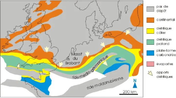
After the Upper Devonian regression, the depositional setting was a carbonate platform which evolved from a ramp at the time of the Devonian/Carboniferous boundary to a rimmed shelf during the early Viséan and to a shelf during the mid- and late Viséan (Figure 4). The shore line was situated along the southern margin of the Brabant Old Land. Tournaisian and Viséan rocks are thus mainly carbonated contrary to those of Pennsylvanian age (‘Namurian’ and ‘Westphalian’) which are terrigenous and include numerous coal seams. Only rare marine incursions have been recorded in the latter. For more details on Belgian Carboniferous lithostratigraphy, see Poty et al. (2002) and Delmer et al. (2002).
For more information on the geology of southern Belgium, see the following references and website: Bultynck and Dejonghe (2002), Dejonghe (2006), and Une introduction à la géologie de la
Wallonie by F. Boulvain and J.-L. Pingot (http://www2.ulg.ac.be/geolsed/geolwal/geolwal.htm).
3
Figure 4. General context of Lower Carboniferous sedimentation in north-western Europe showing the distribution of
emergent areas and Waulsortian mounds at the end of the Tournaisian [modified from Ziegler (1990) and Devuyst and Dehantschutter (2007)]. B = Basin.
STOP 1. TIHANGE
Location
Tihange, trench dug for new road linking the Meuse valley (N90) to the Condroz (N636). Coordinates: N 50°31'52,88" E 05°16'45,46".
Reference
Goemaere et al. 2006. Description
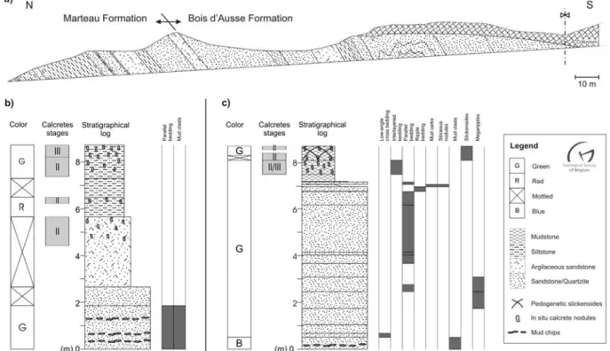
This new section offers an outstanding exposure of the lower part of the Lower Devonian succession developed on the northern border of the Dinant Synclinorium (Figures 5–6). It exposes the upper part of the Fooz Formation of Upper Lochkovian age and parts of the Upper Lochkovian-Pragian Bois d’Ausse Formation. The contact between the Fooz Formation and the Silurian shales is not exposed here. In the section of Huy-South or in the Fonds d’Oxhe, the Fooz Formation unconformably rests on Lower Palaeozoic rocks and starts with conglomerate beds (Poudingue
d’Ombret) overlaid by coarse-grained sandstones locally kaolinitic known as the Dave Member.
The Fooz (= Marteau) Formation is mainly composed of conglomerate, sandstone, siltstone and shale organized in vertically stacked sequences associated with calcretes at various maturation stages. This formation is indicative of a mature fluviatile plain including channels, crevasse-splay and flooding plain.
4 The Bois d’Ausse Formation is more complex with a predominant shoreline environment of tidal type alternating with coastal plain deposits. The lower limit of the formation is placed at the first grey, blue grey or light-coloured quartzite bank overlying the green siltstones and sandstones of the Fooz Formation. The tidal structures are locally overprinted by the growth of pedogenic calcretes. The general sketch indicates a progressive change between a continental setting (Fooz Formation) to a more marine environment illustrating the Lower Devonian ‘transgression’. The persistence of a shoreline environment for the Bois d’Ausse Formation suggests a hitched subsidence.
Figure 5. a) Tihange section. b) Fooz Formation type sequence. c) Bois d’Ausse Formation type sequence (Goemaere
et al. 2006).
Figure 6. SW–NE
schematic cross-section through the Lower Devonian formations at the northern and eastern sides of the Dinant Synclinorium and in the Vesdre Nappe (Hance et al. 1992,
Bultynck and Dejonghe 2002).
5
STOP 2. OMBRET-RAWSA
Location
Yernée road (N696), on the north flank of the Falogne stream. Coordinates: N 50°32'08,14" E 05°20'24,90".
Description
The section displays the unconformable contact between Ordovician siliciclastic rocks assigned to the Huy Formation by Owens and Servais (2007) [= unnamed formation of Llandeilian age of Dean (1991)] and the basal conglomerate (Poudingue d’Ombret) of the Upper Lochkovian Fooz Formation (Figure 7).
STOP 3. PETIT AVIN QUARRY
Location
Disused quarry, southeast of Petit Avin. Coordinates: N 50°24'00, 17" E 05°17'19,82". Description
The quarry exposes the Upper Famennian Montfort Formation which is made up of micaceous, dark grey bluish, sometimes nearly black by weathering. This formation represents a sand barrier complex (see Thorez et al. 2006). Note the presence of point bar deposits.
STOP 4. BOIS D’ANTHISNES QUARRY
Location
Active quarry, south-southwest from the city of Esneux, Ourthe valley. Coordinates: N50°30’01,93’’ E05°33’02,03’’.
Figure 7. Geological
map of the Oxhe Inlier and adjacent area south of the Ombret Fault (Dean 1991). The section corresponds to the locality A.
6 Description
The quarry exposes the Upper Famennian Montfort Formation which includes here metric to sometimes plurimetric charge structures called ‘pseudonodules’ (ball-and-pillow levels) (see Thorez et al. (2006) for more details).
Petrography of Famennian deposits
A detailed study of Upper Famennian sediments shows a great variety in their chemical composition, their granulometry and their colour. These different parameters have a major influence on the use of Famennian sandstones. Besides siliciclastic rocks, there are also carbonate rocks (limestones and dolomites) and a ‘mix’ of silici-carbonated rocks.
The ‘Psammites du Condroz’ are principally composed of fine-grained (from 40 (siltites) to 150 μm) quartzitic sandstones which are generally micaceous, sometimes feldspathic and slightly calcareous. They are disposed in beds of variable thickness. The working of these sandstones has reached a so considerable development that it has supplanted the other deposits of hard sandstone in areas where the ‘Psammites du Condroz’ occur. This is due to the very good mechanical properties of these sandy rocks, their homogeneity and their large distribution. Furthermore, the regularity and the easy sawing of benches allow to produce stones of various forms and shades but also cobblestones, aggregates, slabs and facing stones.
Through the entire Famennian succession, sandstones display significant variations in nature and abundance of the cements, both vertically and laterally. These spatial variations led sedimentologists to define new lithostratigraphic units laterally, subdivided into members, to answer in a more specific way to these lateral variations of facies. The spatial relationships between the different members and formations are highly complex and are based on a precise biostratigraphic pattern. These elements are important enough to be taken into account in any discussion on the use of the Famennian sandstones.
STOP 5. BELLE-ROCHE QUARRY [mainly based on Devuyst and Hance (2003)]
Location and access
Operating quarry located on the right bank of the River Amblève, about 1.5 km upstream to the junction with the River Ourthe. Coordinates: N 50°28'58,01" E 05°36'26,61".
References
Groessens 1975; Conil et al. 1988; Swennen et al. 1990. Description
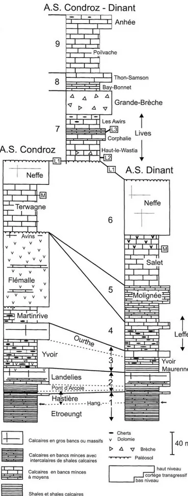
The quarry, located in the eastern part of the Condroz Sedimentation Area (Figures 8–10), displays a section which is continuous from the Ivorian Ourthe Formation (Tournaisian) to the Moliniacian Neffe Formation.
7
Figure 8. Distribution of ‘Dinantian’ rocks in southern Belgium and northern France (Avesnois) and Late Tournaisian
sedimentation areas in the Namur-Dinant Basin (not palinspastic) (modified from Hance et al. 2001). ASA = Avesnois sedimentation area; CSA = Condroz sedimentation area; DSA = Dinant sedimentation area; HSA = Hainaut sedimentation area; NSA = Namur sedimentation area; VASA = Vesdre – Aachen sedimentation area; VSA = Visé sedimentation area.
Figure 9. Organization of Tournaisian and Lower Viséan third order sequences (numbered black arroxs) across the
Namur-Dinant Basin (Hance et al. 2001). The clinoform profile of sequences 5 to 7 indicates the importance of progradation. ASA = Avesnois sedimentation area; ASC = Condroz sedimentation area; ADS = Dinant sedimentation area; HSA = Hainaut sedimentation area; ASN = Namur sedimentation area; VASA = Vesdre – Aachen sedimentation area; VSA = Visé sedimentation area. Formations: BAY = Bayard; ENG = Engihoul; FLE = Flémalle; HAS = Hastière; LAN = Landelies; LEF = Leffe; MAR = Martinrive; MAU = Maurenne; MOL = Molignée; NEF = Neffe; PAR = Pont d’Arcole; SAL = Salet; SOV = Sovet; TER = Terwagne; WAU = Waulsort; YVO = Yvoir.
The lithostratigraphic succession is as follows (in ascending stratigraphic order) (Figure 11): Ourthe Formation (Ivorian)
Thick-bedded to massive crinoidal pack- to rudstone, grey-blue. Macrofauna is abundant but not very diversified (rugose and tabulate corals, brachiopods, etc.). Fresh breaking of the limestone produces a fetid smell.
Martinrive Formation (Ivorian)
Most of the formation consists of dark limestones (pack- to wackestones) with crinoidal concentrations and numerous chert nodules. Its lowermost part contains abundant chicken-wire
8 calcite nodules (pseudomorphs after anhydrite). The uppermost part of the Martinrive Fm is thick-bedded, devoid of cherts, with fine-grained peloidal grainstones and mudstones locally dolomitized. In the Ourthe valley, chicken-wire nodules are also abundant at this level.
Longpré Formation
Flémalle Member (dolomitized) (latest Ivorian)
The member is resting on a palaeokarstic surface on top of the underlying Martinrive Fm and overlaid by the Avins Mbr. It is composed of thick-bedded crinoidal dolostones and some beds of poorly or not dolomitized limestone (packstone- to grainstone with crinoids, corals and large brachiopods). Thickness of the Flémalle Mbr is here about 73 m.
Avins Member (dolomitized, early Moliniacian)
This member, which is 7,5 m thick, consists of thick-bedded to massive light-coloured oolitic dolostone.
Terwagne Formation
The Terwagne Fm (about 90 m thick) is dolomitized; its lower 12 m include thin beds with ripple marks ripples that are overlaid by about 40 m of breccia (Belle Roche Breccia). This solution collapse breccia (at least post-Livian, possibly post-Viséan) affects different formations and has no lithostratigraphical value. It is composed of limestone or dolomite boulders, some of them reaching thousands of cubic meters (‘rafts’ of non-brecciated limestone). The brecciation is originated by solution collapse of evaporitic layers in the Terwagne Fm and can affect the overlying Lives Fm. The top of the Terwagne Fm consists of dark to light-coloured dolostones.
Neffe Formation
This unit consists of massive, light-coloured limestones (bioclastic and oolitic packstones– grainstones).
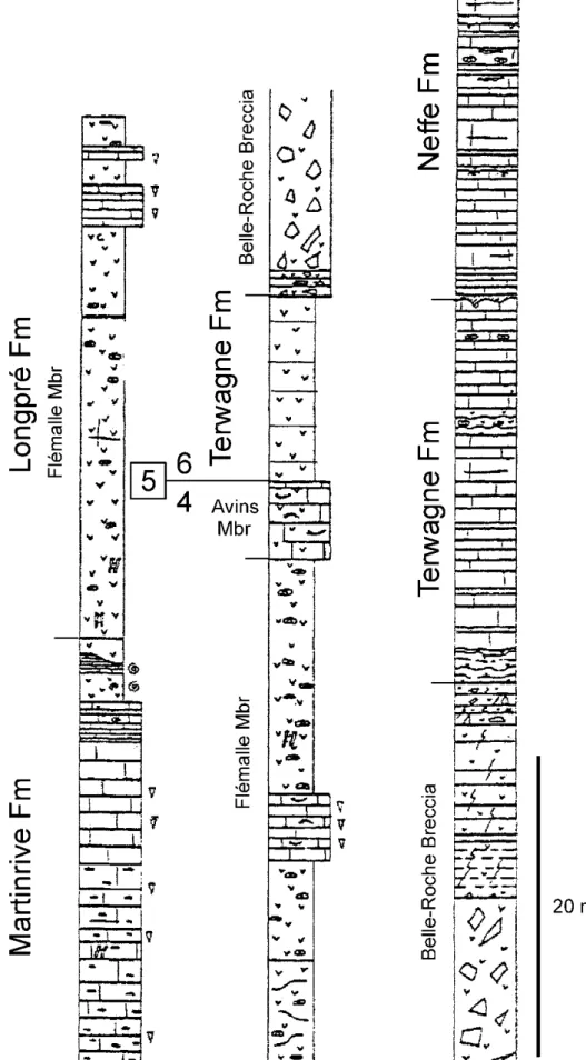
Interpretation and discussion
The crinoidal limestones of the Ourthe Fm form the HST of sequence 3 of Hance et al. (2001) (Figures 9–11). Sequence 4 starts with the cherty limestones and evaporitic facies of the Martinrive Fm as TST. Crinoidal dolostones of the Flémalle Member (Longpré Formation) and oolitic dolostones of the Avins Mbr (Longpré Fm) represent the HST. Sequence 5 is most likely completely lacking as the Terwagne Fm, which corresponds to the TST of the sequence 6, directly rests on the top of the Longpré Fm. The bioclastic and oolitic packstones–grainstones of the Neffe Fm form the HST of sequence 6.
The Longpré Fm has a thicker development westward with about 135 m in the Hoyoux area. High sedimentation rate and progradation of this sedimentary body result in the change between the ramp setting which was governing the Tournaisian sedimentation and the shelf setting of the Viséan sedimentation.
9
Figure 10. Composite lithological
columns for the Tournaisian and Lower Viséan of the Condroz and Dinant sedimentation areas (Hance et al. 2001). M, L1, L2, and L3are ash layers. Hang. = Hangenberg event.
10
Figure 11. Partial lithological column of the Belle-Roche quarry. Note that the sequence 5 is lacking between the Avins
11
References
BULTYNCK P. and DEJONGHE L. 2002. Devonian lithostratigraphic units (Belgium). In Lithostratigraphic scale of
Belgium, BULTYNCK P. and DEJONGHE L. (eds). Geologica Belgica, 4: 39–69.
CONIL R., GROESSENS E., HIBO D., LALOUX M., LEES A., and POTY E. 1988. The Tournaisian-Viséan boundary in the type area. Guidbook, Field Meeting, Palaeontological Association Carboniferous Group, 22– 25 April 1988. Institut de Géologie, Université Catholique de Louvain, Louvain-la-Neuve, 2 vols., 145 pp. DEAN W.T. 1991. Ordovician trilobites from the inlier at Le Petit Fond d’Oxhe, Belgium. Bulletin de l’Institut royal
des Sciences naturelles de Belgique, Sciences de la Terre, 61: 133-155.
DEJONGHE L. (Ed.) 2006. Chronostratigraphic units named from Belgium. Geologica Belgica, 9: 1–224.
DELMER A., DUSAR M. and DELCAMBRE B. 2002. Upper Carboniferous lithostratigraphic units (Belgium). In
Lithostratigraphic scale of Belgium, BULTYNCK P. and DEJONGHE L. (eds). Geologica Belgica, 4: 95–103.
DEVUYST F.X. and DEHANTSCHUTTER J.A.E., 2007. Waulsortian carbonate mud-banks, Belgium. In Facies from
Palaeozoic reefs and bioaccumulations, VENNIN E., ARETZ M., BOULVAIN F. and MUNNECKE A. (eds). Mémoires du Muséum national d’Histoire naturelle, 195: 235–238.
DEVUYST F.X. and HANCE L. 2003. The Dinantian of southern Belgium: sedimentary history. A guidebook of key sections. Shell field trip, April 2003, 64 pp.
GOEMAERE E., GEENINCKX S. and VANBRABANT Y. 2006. Les coupes de Tihange et de Huy : étude paléoenvironnementale des formations de Marteau et de Bois d’Ausse (Dévonien inférieur) au bord nord du Synclinorium de Dinant, Belgique. Géologie de la France, 2006 (1/2) : 35–39.
GROESSENS E. 1975. Distribution des conodontes dans le Dinantien de la Belgique. International Symposium on Belgian micropaleontological limits, Geological Survey of Belgium, Brussels, 193 pp.
HANCE L., DEJONGHE L. and STEEMANS P. 1992. Stratigraphie du Dévonien inférieur dans le Massif de la Vesdre.
Annales de la Société géologique de Belgique, 115 : 119–134.
HANCE L., POTY E. and DEVUYST F.X. 2001. Stratigraphie séquentielle du Dinantien type (Belgique) et corrélation avec le Nord de la France (Boulonnais, Avesnois). Bulletin de la Société géologique de France, 172: 411-426. HANCE L., DEJONGHE L., GHYSEL P., LALOUX M. and MANSY J.L. 1999. Influence of heterogeneous
lithostructural layering on orogenic deformation in the Variscan Front Zone (eastern Belgium).
Tectonophysics, 309: 161–177.
MANSY J.L., EVERAERTS M. and DE VOS W. 1999. Structural analysis of the adjacent Acadian and Variscan fold belts in Belgium and northern France from geophysical and geological evidence. Tectonophysics, 309: 99–116. POTY E., HANCE L., LEES A. and HENNEBERT M., 2002. Dinantian lithostratigraphic units (Belgium). In Guide to
a revised lithostratigraphic scale of Belgium, BULTYNCK, P. and DEJONGHE, L. (eds). Geologica Belgica,
4: 69–94.
OWENS R.M. and SERVAIS T. 2007. The Ordovician of the Condroz Inlier, Belgium: Trilobites from the southeastern margin of Avalonia. Palaeogeography, Palaeoclimatology, Palaeoecology, 245: 272–294.
SWENNEN R., VIANE W. and CORNELISSEN C. 1990. Petrography and geochemistry of the Belle-Roche breccias (lower Viséan, Belgium): evidence for breccia by evaporite dissolution. Sedimentology, 37: 859–878.
THOREZ J., DREESEN R. and STREEL M. 2006. Famennian. In Current status chronostratigraphic units named from
Belgium and adjacent areas, DEJONGHE L. (ed.). Geologica Belgica, 9: 27–45.
ZIEGLER P. A. 1982. Geological atlas of the Western and Central Europe. Shell Internationale Petroleum Maatschappij B.V., Den Haag, 130 pp.
ZIEGLER P.A., 1990. Geological atlas of Western and Central Europe (2nd
edition). Shell Internationale Petroleum

![Figure 4. General context of Lower Carboniferous sedimentation in north-western Europe showing the distribution of emergent areas and Waulsortian mounds at the end of the Tournaisian [modified from Ziegler (1990) and Devuyst and Dehantschutter (2007)]](https://thumb-eu.123doks.com/thumbv2/123doknet/6685756.183433/4.892.86.808.81.567/general-carboniferous-sedimentation-distribution-emergent-waulsortian-tournaisian-dehantschutter.webp)