HAL Id: hal-03142847
https://hal-amu.archives-ouvertes.fr/hal-03142847
Submitted on 16 Feb 2021
HAL is a multi-disciplinary open access archive for the deposit and dissemination of sci-entific research documents, whether they are pub-lished or not. The documents may come from teaching and research institutions in France or abroad, or from public or private research centers.
L’archive ouverte pluridisciplinaire HAL, est destinée au dépôt et à la diffusion de documents scientifiques de niveau recherche, publiés ou non, émanant des établissements d’enseignement et de recherche français ou étrangers, des laboratoires publics ou privés.
environments and determining the sedimentation rate of
south wetlands of Lake Urmia during Late Pleistocene
and Holocene
B Mirzapour, R Lak, Mohsen Aleali, Morteza Djamali, R Shahbazi
To cite this version:
B Mirzapour, R Lak, Mohsen Aleali, Morteza Djamali, R Shahbazi. Identifying the effects of climate changes on sedimentary environments and determining the sedimentation rate of south wetlands of Lake Urmia during Late Pleistocene and Holocene. Pollution, University of Tehran, 2021, 7 (1), pp.113-127. �10.22059/poll.2020.309171.891�. �hal-03142847�
Print ISSN: 2383-451X Online ISSN: 2383-4501 Web Page: https://jpoll.ut.ac.ir, Email: jpoll@ut.ac.ir
Identifying the effects of climate changes on sedimentary
environments and determining the sedimentation rate of south
wetlands of Lake Urmia during Late Pleistocene and Holocene
Mirzapour, B.1, Lak, R.2*, Aleali, M.3, Djamali, M.4 and Shahbazi, R.5
1. Department of Earth Sciences, Science and Research Branch, Islamic Azad University, Tehran, Iran
2. Research Institute for Earth Sciences, Geological Survey of Iran, Tehran, Iran 3. Department of Earth Sciences, Science and Research Branch, Islamic Azad
University, Tehran, Iran
4. French National Center for Scientific Research (CNRS), Paris, France 5. Engineering, Environmental Geology and Hazards Department, Geological
Survey of Iran, Tehran, Iran
Received: 04.08.2020 Revised: 05.09.2020 Accepted: 21.11.2020 ABSTRACT: This study investigated the evolutionary history of the Late glacial in number of wetlands in south part of Lake Urmia. Twenty-six cores with a maximum depth of 12 m, average 8 m and total depth of about 190 m were collected from sediments under the southern and southwestern wetlands using a handi auger. Sedimentary facies were identified and separated based on sediments texture and structure, composition of evaporite minerals and organic materials, also color and other macroscopic elements. The results indicated the presence of eight distinct sedimentary facies belonging to the lacustrine, wetland and fluvial (river) sedimentary environments. In the last 20 cal ka BP, the two dominant dry periods, about 4 cal ka BP and 13 cal ka BP, have been associated with the transgression of dry (alluvial) facies towards the lake and the regression of Lake facies. The dry period 4 cal ka BP affected the southern part of Lake Urmia and marginal wetlands, while the dry period 13000 years ago was more intense and longer and lasted at least 3 cal ka BP.
Keywords: Paleoenvironment, Paleogeography, Sedimentary Cores, Environment changes, Sedimentary evolution, Wetland.
INTRODUCTION
Wetlands are the most important aquatic ecosystems. Due to the presence of water, wetlands are most diverse ecosystems in the planet biologically and are also considered safe areas for wildlife. These environments provide documents and evidence with high sensitivity and clarity which are required to study global climate changes and
*
Corresponding Author, Email: lak@ries.ac.ir
sedimentary environments (Vaezi et al., 2015). Lake Urmia is a significant environmental phenomenon which is recorded in the Ramsar Convention which was held in 1970 with the presence of 120 countries. Lake Urmia also as the largest saline lake in North West of Iran, is also one of the largest hypersaline lakes in the world (Mohammadi et al., 2010; Darvishi Khatooni et al., 2011).
Many studies have been done on Urmia paleolimnology (Mohammadi et al., 2019), history of sedimentation in Urmia Lake (Mohammadi et al., 2010), climate changes in Quaternary (Kiani et al., 2017), Urmia hyper saline lake sedimentology (Kelts et al., 1986), hydrogeochemistry and brine evolution of Urmia Lake (Karbassi et al., 2010; Darvishi khatooni et al., 2015), geomorphology of fault (Pourkermani et al., 2003), fluctuations of Urmia Lake (Esmaeili et al., 2010), changes of Artemia (Darvishi Khatooni. 2016), Holocene paleoenvironmental history (Baumhauer. 2009), pollen record and vegetation changes and its history (Djamali et al., 2008, Litt et al., 2012, Djamali et al., 2009), palynology and geochemistry changes (Akbari et al., 2017, Van Zeist et al., 1977), hydrological changes (Hamzeh et al., 2016, Olsen. 1986), paleoenvironmental changes and sedimentary process (Kwak et al., 2016, Djamali et al., 2008, Sinha et al., 2006, Krillin et al., 2016), evolution and climatic characteristic (Cohen, 2003).
Study of the climate change in lake sediments and the lack of basic geological studies in the wetlands of southern Lake Urmia is important. Paleogeographic and paleoclimatological studies in southern wetlands of the lake and the history of long-standing changes in the southern slopes, can help us to understand the factors affecting the dry and wet periods in this region of Iran and the trend of water table changes in the past. The aim of this study is to find out during Late Pleistocene and Holocene sedimentation history, changes in sedimentary paleoenvironments and reconstruction of environmental conditions and sedimentation of the wetlands on the southern Lake Urmia (Solduz and Kani-Barazan) during Late Pleistocene and Holocene. The results of this study provide this capability to executive managers and planners to make future plans more accurately and reliably.
Lake Urmia is a graben tectonic area in
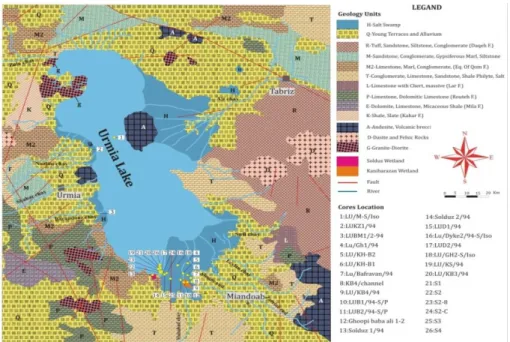
Azerbaijan created by the Tabriz fault in the east and the Urmia fault in the west and it is surrounded by high mountains of over 2000 m height (Shahrabi, 1993). From the geological point of view, this basin is the result of the operation of compressive fault systems such as Tabriz and Zarrineh-rud fault. The Urmia Lake is located in a part of the crushed area between the Saudi and Iranian plates and the fine plates of Iran and Turkey and it can be considered a kind of tectonic lake that high mountains surrounds it. (Aghanabati, 2006). The most important highlands in north of the lake are the Misho and Moro mountains that follow the Alborz mountains and their continuation in northwestern Iran is connected to the mountains of Ararat in Turkey. The southern mountain of Urmia Lake has a similar trend, in fact it`s the sequence of the Zagros mountains. On the eastern side of the lake, mountains with a north-south trend leads to alluvial plains and eastern coastal lakes with gentle slopes. Soft lake deposits are located on the hardened bottom of lower Cretaceous or marly limestones of Miocene (Qom Formation). The Urmia Lake basin is often composed of Miocene carbonate and clastic formations. In contrast to the Islamic island of Pliocene volcanic rocks, the other islands are the Filish of the Cretaceous or limestone of Miocene (Qom Formation) (Fig. 1).
The most important rivers include Zarinerud, Siminehrud, MahabadChay (Soyoq-Bulaq-Chay), GadarChay, BarandouzChay, ShahrChay, RozehChay, NazloChay, ZolaChay, TsuchChay, AjiChay and SufiChay. AjiChay passes from the Neogene salt sediments of eastern Tabriz and carries considerable amounts of salt to Lake Urmia (Aghanabati, 2006) (Fig. 1). The studied wetlands are located in the southern part of Lake Urmia. The southern wetlands of Lake Urmia are one of the most important wetlands of this Lake.
Fig. 1. Geological map and faults around the lake (derived from Shah Hosseini, 2003), Situation of the rivers around the Lake Urmia, Distribution of sampling points and wetlands around Lake Urmia Solduz and Kani Barazan wetlands have
been created under the influence of fresh water imported from the south of the lake and according to the morphological conditions of the region. The most important characteristics of these wetlands in the table 1 are mentioned.
Kani Barazan wetland with 45° and 46' east longitude and 36° 59' north latitude is located 30 km northeast of Mahabad city and the Solduz wetland with geographical coordinates of 37° and 2' north latitude and 45° and 36' east longitude, on the Urmia-Mahabad road and at the end of the drainage line of the Hasanlu dam (Fig. 1).
MATERIALS & METHODS
The different stages of this research include data collection, published statistics data, climatic data, remote sensing surveys, field Work Investigation and coring, laboratory research, field data processing, data analysis and interpretation and conclusion. The cores were collected by a handy auger (eg. Piovano et al., et al., 2002). Position of cores show on the fig. 1. Images were taken from the cores with a digital camera (Model: Canon-G10). The description of the cores was carefully written and sampling was
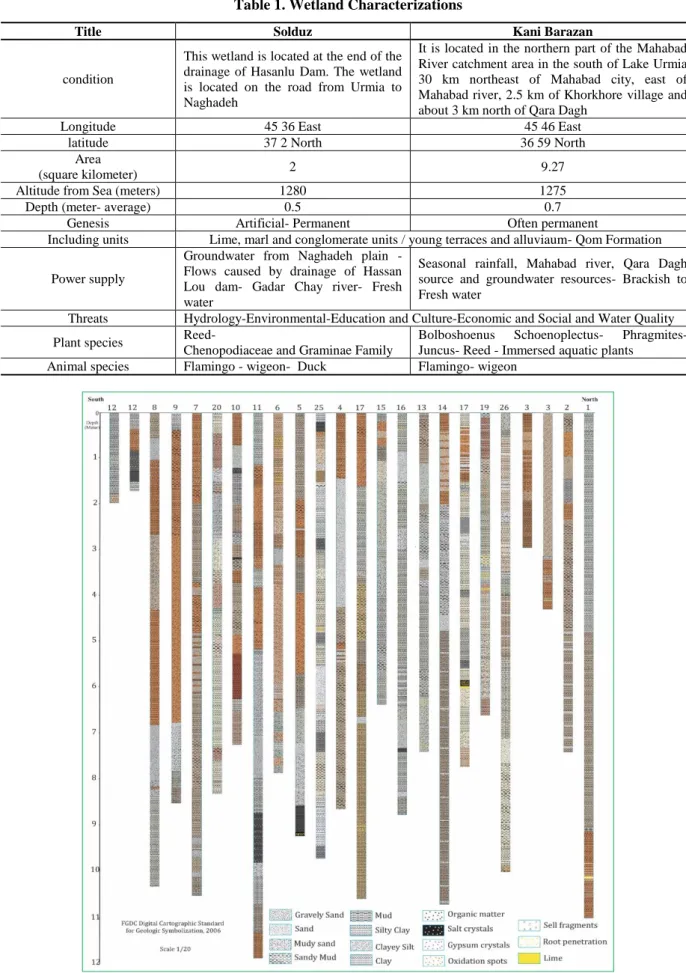
carried out according to the change of facies and sediment type (Fig. 2). Samples were prepared and analyses were performed according to the instructions given by Lewis and Mc Conchie (1994). Based on field observations, core descriptions and changes in the frequency of pellets and laboratory results, the cores were divided in to sedimentary units and based on the evidence given for each facies their stratigraphic columns and the water level of the Lake were plotted with Corel Draw software to determine the sedimentary sub-environment of each units (Li et al., 1996; Valero-Garces et al., 1998; Benison & Goldstein. 2001) (Fig. 2). In this study, radiocarbon dating (14C-AMS) was performed using organic materials and bulk samples (Table 1). The sample age was calibrated by OxCal software (17) with 2 Sigma error range and reliability coefficient of over 95%. These 2 samples were selected based on the presence of organic matter and according to the limitation of sending samples for studying. The samples included organic materials mainly in silt and clay. Dating analysis was performed at the GEOPS laboratory of Paris University.
Table 1. Wetland Characterizations
Kani Barazan Solduz
Title
It is located in the northern part of the Mahabad River catchment area in the south of Lake Urmia 30 km northeast of Mahabad city, east of Mahabad river, 2.5 km of Khorkhore village and about 3 km north of Qara Dagh
This wetland is located at the end of the drainage of Hasanlu Dam. The wetland is located on the road from Urmia to Naghadeh condition 45 46 East 45 36 East Longitude 36 59 North 37 2 North latitude 9.27 2 Area (square kilometer) 1275 1280
Altitude from Sea (meters)
0.7 0.5
Depth (meter- average)
Often permanent Artificial- Permanent
Genesis
Lime, marl and conglomerate units / young terraces and alluviaum- Qom Formation Including units
Seasonal rainfall, Mahabad river, Qara Dagh source and groundwater resources- Brackish to Fresh water
Groundwater from Naghadeh plain - Flows caused by drainage of Hassan Lou dam- Gadar Chay river- Fresh water
Power supply
Hydrology-Environmental-Education and Culture-Economic and Social and Water Quality Threats
Bolboshoenus Schoenoplectus- Phragmites- Juncus- Reed - Immersed aquatic plants
Reed-
Chenopodiaceae and Graminae Family Plant species
Flamingo- wigeon Flamingo - wigeon- Duck
Animal species
Fig. 2. Stratigraphy columns of the cores from the south of Urmia Lake
RESULT AND DISCUSSION
Eight sedimentary facies were described in 24 intact sedimentary cores with a maximum depth of 12 m, minimum 1.7 m, average 8 m were collected from the southern wetlands around Lake Urmia (Fig. 3). In the studied sediment cores, the facies represent three sedimentary environments including lacustrine (Lake), wetland and fluvial (River) environments. Fluvial facies were identified with brown silt mud sediments lacking any organic matter. Wetland facies contain dark gray mud fine-grained sediments with abundant organic matter, plant roots and oxidized zones
around the roots. In contrast, lacustrine facies contain light gray marl sediments rich in Artemia pellets, carbonate rich sediments, coated grains with black sedimentary interlayers rich in organic matter which is indicative of a reducing lacustrine environment. Change in the sedimentation rate in different parts of Lake Urmia is often dependent on water volume and sediment inputs of rivers in the basin. Combining information on statistical parameters and sedimentary facies, sedimentation conditions and paleo environments were reconstructed. The facies in the cores are briefly described below: (Fig. 3).
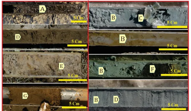
Fig. 3. (A) Brown clay with salt crystals, (B) Soft mud facies in gray, greenish gray, brown and black colors, (C) Coarse-grained secondary Gypsum crystals under the influence of sulfate-rich solutions, (D) fine to medium-grained sand with brown, black and gray colors, (E) Gravel to coarse–grained sand facies in the background of brown mud facies, (F) Bright brown to black organic matter, and (G) Brown clayey silt facies.
Sedimentary environments of the south of Lake Urmia in today's conditions include the environment of the wetland which is Kani Barazan and Solduz wetlands, the alluvial environments that has been created under the influence of Zarrineh and Siminehrood rivers and the lake environments which indicates the impact of Urmia Lake. Also, each of the main environments has sub-environments
that change from heights to the plains and from the margins to the center of the lake (Fig. 4). These sedimentary environments have been affected by many changes in different time periods and lateral and longitudinal shifts have occurred in the type of environments. Therefore, in the taken cores, these sediments have been repeated alternately.
Fig. 4. The model of recent sedimentary environment
Salt facies (Ha): Salt facies are often
found on the surface of salt pan. salt crystals with an approximate thickness of 2 to 5 cm in wet season. With continued drying of the Lake (dry season), the thickness of salt facies increases rapidly. Salt facies are also found in the core collected from Lake Urmia Bridge. It can be observed at a depth of about 9 m with a thickness of less than 10 cm. It often indicates a playa environment.
Clayey silt facies (CS): The clay silt
facies with a considerable thickness are observed in the cores collected from the wetlands around Lake Urmia. These facies are visible with different colors and characteristics at different depths. Clay silt facies are observed with black, dark gray, bright gray, gray, dark green to bright green, bright brown to dark brown, and interspersed colors. Depending on the sedimentary environment, it contains salt crystals, gypsum, oxidant spots, organic matter spots, shell fragments and plant remnants. The sedimentary environment of clay silt facies is different according to the different side features representing fluvial (River), wetland and lacustrine (Lake) environments.
Clay facies (C): Clay facies are visible
in a variety of colors in the stratification column of cores including bright gray, bright brown, dark brown and black colors. Oxidant spots, black organic matter spots and plant remains and plant roots are found in clay facies in some cases. Clay facies are sometimes observed between sand facies as small lenses. Dark color indicates a reducing environment and the presence of a considerable amount of organic matter demonstrates a lacustrine environment (Reading. 1996). It is usually located under a thick layer of salt as stinky sludge (Warren. 2000).
Laminated sediments indicate higher water table than massive sediments (Mees, 1999). The brown color of clay facies is due to weathering and the presence of brown iron oxide and represents sediments of a dry period (Moosavi Harami. 2002) with a negligible precipitation rate (Li et al., 1996). Brown clay facies containing coarse-grained gypsum are found at a depth of 7 m. The size of gypsum crystals may exceed 5 cm. The gypsum crystals are formed and grown due to contact with SO4-rich brines43. Clay facies are often
related to the flood plain sedimentary environment.
Mud facies (M): The mud facies with a
relatively large thickness are found in the columns of collected cores. Mud facies are visible at different depths with different characteristics and colors including black, gray, dark green to bright green and bright brown to dark brown. Dependent on the sedimentary environment, it contains oxidant spots, organic matter spots, the crust of the shell fragments and plant roots. Extremely dense and sticky brown mud is frequently observed in the cores collected from the Lake Urmia at the end of the cores at a depth of 8 m which lacks any
Artemia pellets and it`s drilling is very
difficult because of low water content, compression, adhesion and high density.
Silty clay facies (SC): The facies are
observed in some of the cores collected from southern wetlands at a short distance from Lake Urmia with a very limited thickness. It is often observed with a bright gray color and in some cases with a grayish-brown color. The thickness of silt clay facies does not exceed 20 cm and is mainly made from aragonite muds. Silt clay facies also indicate a lacustrine environment (Lak et al., 2012).
Sand facies (S): The facies include fine
to coarse-grained sand of intra basin-clastic type with a bright gray color. It contains organic matter and small amounts of
Artemia pellets in some places. In some
areas and depths, sand and mud facies are observed alternately with a very low thickness. In some cases, the mud facies are seen as small lenses between the sand facies. Sand facies are often formed in the delta of rivers entering the Lake and laid in the Lake margin. It therefore represents a lacustrine environment(Lak et al., 2004).
Muddy sand facies (MS): There are
sandy mud and muddy sand facies with a limited thickness in the columns of collected cores. These facies are visible with different colors and characteristics at
different depths. It is often observed in dark green to bright green and bright brown colors. Dependent on sedimentary environment, it contains oxidation spots, organic matter spots, quaternary fossils, and plant roots. The sedimentary environment of this facies is different according to the different side features, but it often indicates a wetland environment.
Gravel facies (G): Gravel facies are
often visible in the mouth of the rivers as pure or mixed with other sediments as a result of coarse-grained sediments transportation by river currents and their entry into the Lake environment. Gray gravel facies indicate the upstream environment of the river delta.
Given the existing sedimentary facies, fluvial, wetland and lacustrine sedimentary environments are detectable (Fig. 6 and 7). After determining the sedimentation status and sediment type, cores were collected from the current lacustrine and wetland environments to investigate the changes in the water level over time, regression and transgression of coastal lines and the effect of these changes on existing marginal wetlands (Fig. 7). To reconstruct the history of Lake sediments, dating is obviously necessary to determine the sedimentation rate. There are several studies on dating of Lake Urmia. While reviewing literature, the most credible and closest range to the studied area was used.
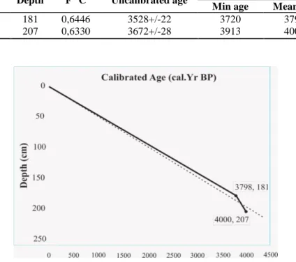
According to the results of Lake Urmia sediments dating with a method of Isotope carbon 14, the sedimentation rate varies from 0.1 to 1 mm per year (Kelts and Shahrabi. 1986). An average sedimentation rate of about 0.5 mm per year has been reported in some references (Lak et al., 2012). Given the 14C dating results (Table 2) (Fig. 5) of two plant remnant samples in the cores collected from the southern wetlands, the calibrated age is about 0.5 mm per year which confirms the results of Lak et al., 2012too.
Table 2. Dating of a sediments sample in southern and southwestern wetlands of Lake Urmia using14C methods.
sample comment Depth F14C Uncalibrated age Calibrated Age (cal. Yr BP) Min age Mean age Max age
AT S1 2 181CM 181 0,6446 3528+/-22 3720 3798 3877
AT S1 B2 207 207 0,6330 3672+/-28 3913 4000 4087
Fig. 5. Depth Model of Age- Depth for dating samples The analysis of sedimentary facies has
been done to interpret sedimentary environments. In this study, wetland sediments in south of Lake Urmia are divided into three groups of clastic, chemical and organic sediments. Clastic sediments are often carried by rivers from upstream formations into the basin. When the weather is warm and wet with a large precipitation rate, large amounts of clastic sediments enter the Lake. Under such conditions, coarse-grained gravel and sand sediments are deposited in the margin of the Lake while fine-grained suspended silt and clay sediments are carried to the central areas of the Lake and are deposited in a calm environment (Mousavi harami, 2002). Therefore, the sedimentation rate on the margin is more than the central areas of Lake Urmia (Lak et al., 2007). As a result, the frequency of clay minerals represents periods of high water content.
Therefore, more sediments are deposited in the southern part of Lake Urmia. Other sediments in the bed of
southern wetlands include chemical and biochemical sediments.
Chemical sediments are the main deposits of hyper saline Lakes. In general, with increasing salinity levels, carbonates, sulfates (gypsum and anhydrite) and chlorides (halite) are respectively formed (Warren, 2006). Before the recent drought of Lake Urmia, chemical and biochemical sediments accounted for about 50-60% of total lacustrine sediments (Mohammadi, 2005). The ratio of chemical and biochemical sediments to clastic sediments is an important indicator for environmental and weather conditions. Also, Variations of the evaporite components and clay minerals in sediments, indicate the weather conditions. The most important chemical and biochemical components of the Lake sediments include aragonite muds, coated grains, gypsum and evaporite minerals. With increasing evaporation rate, the salt percentage in the Lake increases and
Artemia Aragonite is a common type of
deposited from high-magnesium brines (Kinsman & Holland, 1969). which is capable of survival in a certain range of salinity is lost.
As a result, fecal pellets that form an important part of carbonate sediments are also decreased. When the sediments of the wetland have pellets, it means that the wetland could be a part of the lake. Carbonate muds are the main constituents of lakes carbonate sediments which were mainly formed due to the biological activity of Photosynthetic algae and the release of CO2 from the environment.
Photosynthetic algae and the release of CO2 from the environment. With
increasing evaporation rate and subsequent increased salinity of the environment, Photosynthetic organisms are reduced or eliminated. Consequently, the production of carbonate muds by biochemical methods is reduced and even stopped. With increasing salinity in the environment and stratification of the water column, oxygen deficiency occurs in the basin floor.
The frequency of carbonate sediments decreases with increasing salinity and decreasing evaporite sediments (Sonnenfeld, 1984). Evaporite deposits are among chemical components of sediments. The most important evaporite minerals found in the lacustrine sediments include: halite, gypsum and anhydrite and to a lesser extent, other evaporite minerals such as polyhalite, hexahydrate, kieserite, carnallite and bischofite.
The mentioned evaporitic minerals are present in the studied wetlands, but no conversion clay minerals such as bischofite and chrysite have been observed.
These minerals are formed during dry periods due to increased salinity (Touloei, 1998). Among evaporite minerals, gypsum and halite are more important. A relative decrease in evaporite minerals is observed by increasing the depth of samples. This indicates an increase in the salinity of the Lake water over time. Another type of
sediments in the southern wetlands of Lake Urmia is organic sediments which are often observed on the margin of the Lake and in freshwater wetlands. These sediments often contain black plant remnant formed in reducing environment. The study of sediment sequences suggests that sediments have been formed in a hyper saline environment with the sequence of clastic and chemical sediments. This sequence in marginal environments and freshwater wetlands is associated with organic deposits. Kani Barazan and Solduz wetlands in the current conditions are located in an isolated environment (wetland). These conditions are similar to the paleo-conditions in many cases with different sedimentary conditions in some cases. The environmental conditions of lakes and wetlands were the same and formed a single environment in most past periods but today represents a separate environment.
So moving to the past, analysis of the sedimentary conditions of the Lake and surrounding wetlands becomes more difficult than the current situation.
In this study has been tried to reconstruct paleogeography and paleoclimate of the region with different data obtained from south wetland of Lake Urmia.
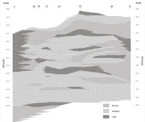
As seen, the water level on the south-east is the highest possible level in the lacustrine environment. By converting the lacustrine environment to the wetland and then the fluvial environment, the water level is gradually reduced and moves to the left. The transformation of sedimentary environments into each other has frequently occurred in the southern wetlands of Lake Urmia so, the current wetlands have been affected by lacustrine environments in most cases. As seen in the cores collected from the southern wetlands of lake Urmia, from top to 650 cm depth, evidences indicate that the lacustrine environment was dominated (with an average rate of 0.5 mm per year, about 13cal ka BP) (Fig. 7).
Fig. 6. Approximate consistency of sedimentary environments in the cores obtained from southern wetlands (right to left: from south to north)
The major drought has started at a depth of about 700 cm of the core. The cores with boundary conditions shows drought periods and red sediments are frequently observed in the cores. This suggests that major droughts in Iran reduced the size of the Lake. It should be indicated according to the mentioned depth in studied range of Lake Urmia a major drought did not occurred and past droughts have only affected the margins of the Lake (Red sediments) (Fig. 7). So, this unprecedented drought indicates the effect of anthropogenic factor on recent Lake Crisis (Lak et al., 2012).
Considering the features of facies in the cores from north to south which were previously collected by Kelt and Shahrabi (1986), the continuity of lacustrine sediments is the evident of last few thousand years. The results of cores and seismic data analysis indicate that a drought period and channel filling at the
beginning of the Holocene (about 12cal ka BP) or the end of ice age had occurred. This was associated with creation of a playa-muddy zone during which 5 to 8 gypsum horizons in red mud were replaced with the playa phase of a permanent shallow hyper saline lake.
This situation shows an interesting consistency with the cores of the southern wetlands which is associated with the transgression or presence of alluvial facies.
Among different regions, Africa and South Asia have a Monsoon climate pattern (Cohen, 2003). Since Lake Urmia is located in a region with the historic Monsoon climate model, it follows the same pattern (Kutzbach & Otto-Bliesner, 1982). These monsoons have caused plant growth in arid regions of North Africa (Street-Perrott et al., 1990).
The surface of Lakes was again reduced on a regional scale during the middle
Holocene and another drought occurred 5500 cal BP (Gasse, 2001). The sequence of sediments in the Holocene generally does not represent a wide range of sediment types. For regeneration, according to Fig. 6, major sedimentary environments include floodplain and alluvial deposits, freshwater wetlands and saltwater lake environments.
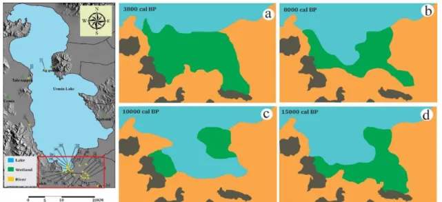
Due to the number of cores from different sedimentary environments in the Kani Barazan, Solduz and surrounding lands, three environments have been identified for the map of 15cal ka BP which has a remarkable development of wetland habitats. Different time scales are available using the average sedimentation rate according to the history of radiocarbon (Fig. 7).
The results of this study indicate that the lake was more extensive in 15cal ka BPyears ago. With regard to Lake Urmia following the conditions of the lakes in the region of Africa and Asia, the decline in water table levels reversed from 12.5cal ka BP and peaked at 9-10cal ka BP (Lak et al., 2012). This increase in lake water table levels occurred fast in the southern region, then moved to the north through the middle Holocene (Fig. 6).
Increasing the water table with the regressive of coastline has continued and the expansion of the lake has occurred to the bed of the Zarrineh River and divided southern part of the lake the lagoon into two sections. This may be due to the separated entry of the Simineh rood and Zarrineh rood rivers, based on high volume of water entry, high groundwater level or the ability of the rivers to flood from the crater or edge (coast) and low evaporate, basically have created a wetland (Fig. 6).
With regards to mentioned situation there was not enough time to form organic matter (Pete). The presence of signs of different sedimentation phases and insufficient growth of plants indicates the high rate of coastal sediments and a rapid increase in the
water table level. About 8cal ka BPwith regression of the coast lines to the Lake and its replacement with wetlands, dominating of wetlands on some parts of the Urmia Lake is visible. Compared to the current situation, the level of water table has been higher (Fig.7). The presence of evaporation and the spread of organic matter indicate a moderate regression of the lake and a slow spread in the southern wetlands of the lake. In other words, the Kani Barazan and Solduz wetlands have been created in the south of the Lake Urmia about 4 cal ka BP, although in some periods they have suffered from drought, but they have created the wetland environments again. (Fig. 7).
This period has been associated with the coastline regression of the southern part of Lake Urmia, which has caused the creation of Kani-Barazan and Selduz wetlands in the southern part of the lake. This relatively dry period in southeastern of Iran has also been reported by Vaezi et al., (2019) in Hamoon Jazmourian and Gorjazkaite et al., (2018) in Jiroft, which shows a good similarity with the dry period about 4200 cal BP. However, it is possible to have a slight precedence and delay in the beginning and the length of the dry period.
The coastline regression started with a decrease in the level of water table about 5500 cal BP and simultaneously with the creation of dry conditions it was possible to extend the cross section. Due to the facies consistency of the cores, with the regression and drying of the Lake shoreline, the expansion of the alluvial facies occurred about 5cal ka BP in the studied area and also in all the cores, alluvial conditions have been replaced with previous wetland environments at a depth of 2.5 meters (Fig. 6).
According to the facies in the taken cores of the southern part of Lake Urmia and also Fig. 6, reducing the water table of Lake has continued up to 2500 cal BP and the high rate of river sediments, especially Zarrineh rood, has overcome the level of
water table. Considering the taken cores and the reconstruction of past sedimentary environments, it can be concluded that during the Holocene, the water table level of lake was higher than now and the lake
environment has dominated and changes in sedimentary environments of the Kani Barazan and Solduz wetlands were often interfingering changes between lake environments, wetland and river (Fig. 7).
Fig. 7. Reconstruction of the sedimentary environments of the Kani Barazan and Solduz wetlands and surrounding lands over the past 15,000 years
CONCLUSION
Sedimentology, paleoclimatic and paleogeography of southern wetlands of Lake Urmia were studied and the following results were obtained. The studied core sediments and facies showed lacustrine, wetland and fluvial sedimentary environments. According to the sequence of sediments, drought periods can be detected with an increase in the amount of chemical sediments, especially evaporite minerals, while wet periods can be detected by increasing the amount of clastic sediments.
According to the sedimentation rate in Lake Urmia, the studied cores are related to the Holocene. A drought period was observed in cores with a depth of about 7 m characterized by brownish red continental sediments. The approximate age of this drought period is about 13 cal ka BP. This drought period in the southern wetlands of Lake Urmia was associated with intruding of alluvial facies.
A drought period is not seen in lacustrine sediments at a depth of 2-3 m with an age of about 5,000 years, but it has been
accompanied by the dominance of alluvial facies in the southern wetlands. It seems that this short-term drought period has been occurred with erosion caused by seasonal floods. Continuous sedimentation in the hypersaline lake is seen from the early Holocene to now (except for the border areas) indicating the long-term stability of the lacustrine environment that has not been affected by various droughts. The southern wetlands of Lake Urmia have undergone significant changes and had fluvial, wetland and lacustrine environments during the Holocene. From the south to the north, the amount of fluvial facies was reduced and the number and thickness of lacustrine facies were increased. The climate and the evolutionary history of Holocene in the southern and southwestern wetlands of Urmia Lake in Iran were reconstructed. Facies and past sedimentary environments were identified in Southern part of Urmia Lake during the Holocene. Drought and wet periods in the Holocene sedimentary sequence and displacement of sedimentary environments recognized. Moisture changes
in the northwest of Iran compared with closed watersheds of central Iran and Zagros during the Holocene. Sedimentation rate in southern Urmia Lake determined and the separation of cumulative and chemical deposits in lake bed sediments defined.
ACKNOWLEDGMENT
We would like to express our sincere gratitude to Sciences and Research Branch, Islamic Azad University, French National Center for Scientific Research (CNRS), GEOPS laboratory of Paris university and all the professors, friends and colleagues who provided insight and expertise that greatly assistant this research and especially the Geological Survey of Iran (GSI), that supported us and provided all facilities, equipment and instruments also finally we sincerely thank the all editors and reviewers.
GRANT SUPPORT DETAILS
The present research did not receive any financial support.
CONFLICT OF INTEREST
The authors declare that there is not any conflict of interests regarding the publication of this manuscript. In addition, the ethical issues, including plagiarism, informed consent, misconduct, data fabrication and/ or falsification, double publication and/or submission, and redundancy has been completely observed by the authors.
LIFE SCIENCE REPORTING
No life science threat was practiced in this research.
REFERENCES
Aghanabati, A. (2006). Geology of Iran (in Persian). Geological survey of Iran, p 500.
Akbari, T., Lak, R., Shahbazi, R., Ghadimi, M., Asadi, A., Karami, F., Wigand, P., Alizadeh, K. A. and Behling, H. (2017). Geochemistry and palynological analysis of Gahar lake sediments and paleoclimate identification of the high Zagros. Quaternary J. of Iran, 2(1):27-40.
Baumhauer, R., and Runge J. (2009). Holocene
Paleo-environmental history of the central Sahara. J.Paleoecology of Africa, 39-62.
Benison, K. C., Goldstein R. H. (2001). Evaporites and siliciclastics of the Permian Nippewalla group of Kansas, USA: a case for non-marine deposition in saline lakes and saline pans. J. Sedimentology 48:165-188.
Cohen, A. S. (2003). Paleolimnology: The history and evolution of lake systems. Oxford University press, p 500.
Darvishi Khatooni, J. (20110). Limnology and paleolimnology of Urmia Lake, phase IV: Hydrochemistry of Urmia Lake (in Persian). Geological survey of Iran, p 80.
Darvishi khatooni, J., Lak, R. and Mohammadi, A. (2015). Hydrogeochemistry and Brine Evolution of Urmia Hyper Saline Lake, Northwest of Iran. J. Geo. Sci. 24: 239-252.
Darvishi khatooni, J. (2016). The abundance changes of Artemia Urmiana pellets in bed sediments of Urmia Lake with a view to the paleoclimate. J. of wetland Ecobiology 8(2):47-62. Djamali, M. (2008). Paleo-environmental changes in Iran during the last two climatic cycles (vegetation climate-anthropisation), Ph.D thesis, Sciences and Techniques faculty, university of Paulsezanne (AIXMARSEILLE III), 194 p.
Djamali, M., de Beaulieu, J-L., Miller, N. F., Andrieu-Ponel, V., Ponel, P., Lak, R., Sadeddin, N., Akhani, H. and Fazeli H. (2009). Vegetation history of the SE section of the Zagros Mountains during the last five millennia; a pollen record from the Maharlou Lake, Fars Province, Iran, J. Veget Hist Archaeobot 18:123–136.
Esmaeili Dahesht, L., Negarestan, H., Eimanifar, A., Mohebbi, F. and Ahmadi, R. (2010). The fluctuations of physicochemical factors and phytoplankton populations of Urmia Lake, Iran. Iranian Journal of Fisheries Sciences 9 (3):368-38. Gasse, F., (2001) Hydrological changes in Africa. Science 292. P 2259-2260.
Hamzeh, M. A., Gharaie, M. H., Lahijani, H., Djamali, M., Mousavi-Harami, R. and Naderi-Beni, M. (2016). Holocene hydrological changes in SE Iran, a key region between Indian Summer Monsoon and Mediterranean winter precipitation zones, as revealed from a lacustrine sequence from Lake Hamoun. J. Quaternary International, 408: 25-42.
Kelts, K. and Shahrabi, M. (1986). Holocene sedimentology of hypersaline Lake Urmia, Nortwestern Iran. J. Palaeogeography, Palaeoclimatology, Palaeoecology 54:105-130.
Kiani, K., Ramest, M. H., Maleki, A. and Safakis, H. F., (2017). The study of climate change in the Gavkhooni basin in the Quaternary final phase, Natural Geography Research, No. 2, pp. 213-229. Kinsman, D. JJ. and Holland, H. D., (1969). The co-precipitation of Sr2+ with aragonite between 16° and 96°C. J. Geochimica et Cosmochimica Acta 33:1-17.
Kirillin, G. and Shatwell, T., (2016). Generalized scaling of seasonal thermal stratification in lakes. J. Earth Science Reviews 161:179–190.
Kutzbach, J. E. and Otto-Bliesner, B. L., (1982). The sensitivity of the African-Asian monsoonal climate to orbital parameter change for 9000 years B.P. in a low resolution general circulation model. J. of Atmospheric Sciences 39:1177-1188.
Kwak, k. Y., Choi, H. and Cho, H. G., (2016). Paleo-environmental change during the late Holocene in the southeastern Yellow Sea, Korea. Applied Clay Science. CLAY-03857: Page1-7. Lak, R. and Gharib, F., (2004). Investigation of coastal zone and near shore of south east of Caspian Sea by satellite data. 32th international geological congress, Florence, Italy.
Lak, R., Fayazi, F. and Nakhaei, M., (2007). Sedimentological evidences of a major drought in the Mid-Late Holocene of the Lake Maharlou, SW Iran. 4th International Limnogeology Congress, Alghero, Italy.
Lak, R., Darvishi Khatooni, J. and Mohammadi, A., (2012). Paleolimnology study and causes of Sudden decrease in water level of Urmai Lake (in Persian). J. Applicable Geology, Zahedan University press 4:357-372.
Lewis, D. W. and McConchie, D., (1994). Analytical Sedimentology, Chapman and Hall. New York, London, p 197.
Li, J., Lowenstein, T. K., Brown, C. B., Ku, T. L. and Luo, S. A., (1996). 100 ka record of water tables and paleoclimates from salt cores, Death Valley, California. J. Paleogeography, Paleoclimatology, Paleoecology 123:179-203. Litt, T., Ohlwein, C., Neumann, F. H., Hense, A. and Stein, M., (2012). Holocene climate variability in the Levant from the Dead Sea pollen record. Q Sci Rev 49:95–105.
Mees, F., (1999). Textural features of Holocene perennial saline lake deposits of the Taoudenni-Agorgott basin, northern Mali. J. Sedimentary Geology 127:65-84.
Mohammadi, A., (2005). Depositional history of Holocene deposits in Urmieh Lake, based on the
cores collected along the SH-K Highway. M.SC thesis (in Persian). Sedimentology and sedimentary petrology, Tehran University, p 127.
Mohammadi, A., Lak, R. and Darvishi khatooni, J., (2010). Study history of sedimentation by Cores in the west of Urmia Lake (South of shahid kalantari highway) (in Persian). 14th Geological Community Conference of Iran and 28th Geo Sience Congress, Urmia, Iran.
Mohammadi, A., Darvishi Khatooni, J., Salehipour Milani, A., Kaveh Firooz, A. and Lak, R., (2019). Genesis of microland forms of mud and salt zones of Lake Urmia. Iranian Quaternary Quarterly journal (Scientific-Research), V. 5 No. 2 Summer 2009 pp. 237-262.
Mousavi harami, R., (2002). Sedimentology. Astan Qods Razavi Publication, 8th edition p 474. Olsen, P. E., (1986). A 40-million year lake record of early Mesozoic orbital climatic forcing. Science 234:842-848.
Piovano, E. L., Ariztegui, D. and Moreiras, S. D., (2002). Recent changes in Laguna Mar Chiquita (central Argentina): a sedimentary model for a highly variable saline lake. J. Sedimentology 49: 1371-1384.
Pourkermani, M. and Sediq, H., (2003). Geomorphologic phenomena of Tabriz fault. J. Geography and Development 2:37-44.
Reading, H. G., (1996). Sedimentary Environments, Processes, Facies and Stratigraphy. 3rd edition, Blackwell Science, Oxford. p 688. Shah Hosseini, M., (2003). Sedimentology of Urmia Lake Basin in the middle section of Shahid Kalantari Highway with a special approach to the origin of sediments, under the guidance of Dr. Abdolhossein Amini, Master's Thesis, Faculty of Science, University of Tehran, 98 pages.
Shahrabi, M., (1993). Geology of Iran (Sea and Lakes of Iran). Geological Survey of Iran (in Persian). p 291.
Sinha, R., Smykatz-Kloss, W., Stuben Harrison, S. P., Berner, Z. and Kramar, U., (2006). Late Quaternary paleoclimatic reconstruction from the lacustrine sediments of the Sambhar playa core, That Desert margin, India. J. Paleogeography, Paleoclimatology, Paleoecology 233:252-270. Snnenfeld, P., (1984). Brines and Evaporates. London: Academic Press. p 613.
Street-Perrot, F. A. and Mitchell, J. B. F., (1990). Milankovitch and albedo forcing of the tropical monsoon: a comparison of geological evidence and numerical simulations for 9000 Ybp. Transactions
Pollution is licensed under a "Creative Commons Attribution 4.0 International (CC-BY 4.0)" of the Royal Society of Edinburgh: Earth Sciences
8:407-427.
Touloie, J., (1998). Hydrogeochemistry of Urmia Lake (in Persian). The First Oceanology Conference of Iran, p 20-23.
Vaezi, A. R., Karbassi, A. R., Valavi, S. and Ganjali, M. R., (2015). Ecological risk assessment of metals contamination in the sediment of the Bamdezh wetland, Iran. International journal of environmental science and technology, 12(3), 951-958.
Vaezi, A., Ghazban, F., Tavakoli, V., Routh, J., Beni, A. N., Bianchi, T. S. and Kylin, H., (2019). A Late Pleistocene-Holocene multi-proxy record of climate variability in the Jazmurian playa, southeastern Iran. Palaeogeography, Palaeoclimatology, Palaeoecology, 514, 754-767.
Gurjazkaite, K., Routh, J., Djamali, M., Vaezi, A.,
Poher, Y., Beni, A. N. and Kylin, H., (2018). Vegetation history and human-environment interactions through the late Holocene in Konar Sandal, SE Iran. Quaternary Science Reviews, 194, 143-155.
Valero-Garces, B.L., Grosjean, M., Kelts, K., Schreier, H. and Messerli, B., (1998). Holocene lacustrine deposition in the Atacama Altiplano: facies models, climate and tectonic forcing. J. Paleogeography, Paleoclimatology, Paleoecology 151:101-125. VanZeist, W. and Bottema, S., (1977). Palynological Investigations in Western Iran. Paleohistoria, Vol. 19, PP. 19-85.
Warren, J., (2000). Evaporites: their evolution and economics. Oxford, Blackwell Science, p 438. Warren, J., (2006). Evaporates: sediments, resources and hydrocarbons. Springer, Berlin, p 1035.