HAL Id: hal-01780728
https://hal.archives-ouvertes.fr/hal-01780728
Submitted on 27 Apr 2018HAL is a multi-disciplinary open access archive for the deposit and dissemination of sci-entific research documents, whether they are pub-lished or not. The documents may come from teaching and research institutions in France or abroad, or from public or private research centers.
L’archive ouverte pluridisciplinaire HAL, est destinée au dépôt et à la diffusion de documents scientifiques de niveau recherche, publiés ou non, émanant des établissements d’enseignement et de recherche français ou étrangers, des laboratoires publics ou privés.
Assessment of kite born DEM accuracy for gullies
measuring
Mohamed Amine El Maaoui, Denis Feurer, Olivier Planchon, Mohamed
Rached Boussema, Mohamed Snane
To cite this version:
Mohamed Amine El Maaoui, Denis Feurer, Olivier Planchon, Mohamed Rached Boussema, Mohamed Snane. Assessment of kite born DEM accuracy for gullies measuring. Journal of Research in Envi-ronmental and Earth Sciences, Knowledge Journals 2015, 3, pp.118-124. �hal-01780728�
Research article
Assessment of kite born DEM accuracy for gullies measuring
Mohamed Amine El Maaoui a,*, Denis Feurer b, Olivier Planchon b, Mohamed Rached Boussema a, and Mohamed Habib Snane a
a
El Manar University, National Engineering School of Tunis, LTSIRS, B.P 37, 1002 Tunis-Belvédère Tunis, Tunisia.
b
Institut de Recherche pour le Développement (IRD), UMR LISAH INRA-IRD-SupAgro, Bât. 24, 2 place Viala, 34060 Montpellier Cedex 2, France.
* Corresponding author. Tel.: +216 24961294; E-mail address: maaouiamine@yahoo.fr Article history:
Received 5 December 2015; Received in revised form 25 December 2015. Accepted 10 January 2016; Available online 15 January 2016.
Abstract
In Tunisian semi-arid areas, human pressure, torrential rains and low vegetation cover are the essential factors of gully erosion. In these areas, gullies naturally exhibit complex morphologies. Hence they are difficult to measure. This type of erosion, in its most severe form, threatens cultivated lands by the extension of badlands as well as water resources by water reservoir sedimentation. For a long time, the objective of most gully erosion studies was the morphological characterization of the gullies in order to properly understand erosion processes. Gradually, the technological advancement in sensors and platforms for aerial image acquisition made it possible to achieve more detailed mapping of gullies. During the last decade, low altitude aerial platforms have experienced the strongest development in acquiring high-resolution aerial photographs and generating associated digital elevation models (DEMs), in particular with the rise of structure from motion algorithms use in geosciences. Such DEMs meet the need for mapping at the sub-meter scale as well as the capability of studying the gullies in three dimensions. In previous studies, a DEM and the corresponding orthophotography were produced at very high resolution (6.2 cm for the DEM, 3.1 cm for the orthophotography). The 3D reconstruction was performed from overlapping images taken from a consumer grade camera hung down a kite. Such experiments, producing unusual aerial datasets, are poorly reviewed in the literature. Therefore, the objective of this paper is to assess the accuracy of such DEMs obtained from overlapping aerial photographs taken from kite platforms.
Key words: Gully erosion, Kite platforms, High-resolution images, DEM accuracy, Structure
From Motion, SfM.
© 2015 Published by Knowledge Journals KJ.
1. Introduction
In Tunisian semi-arid areas, gullies are the typical form of water erosion. Its growth rates and shapes were found to be lithology dependent (El Maaoui et al., 2012; Parkner et al., 2006; Tamene et al., 2006; Thompson et al., 2006). In these
areas, gullies naturally exhibit complex
morphologies. Hence, they are difficult to measure. Most of the studies on gully erosion aim to estimate the spatial and temporal evolution of
gullies. They are consequently descriptive studies dealing with geometry and erosion process than 3D monitoring.
Gradually, the technological advancement in sensors and platforms for aerial image acquisition (Colomina and Molina, 2014), made it possible to achieve more detailed mapping of the gullies. Indeed, lightweight platforms such as UAVs and kite are being the most used to provide high resolution imagery and to generate associated
M.A. El Maaoui et al. 2015
digital elevation models (DEMs). Such data allow to precisely understand gully geomorphology (Gimenez et al., 2009; Marzolff and Poesen, 2009; Oleire-Oltmanns et al., 2012), which is commonly facilitated by the rapid progress of structure-from-motion (SfM) algorithms and software which offer significantly easier image processing workflows than traditional aerial photogrammetric techniques (James and Robson, 2012; James and Robson, 2014; (Fonstad et al., 2013)). Unlike field
measurements, these indirect measuring
techniques allow covering of large study areas with a minimum of time and effort (Martinez-Casasnovas et al., 2004). The accuracy of the 3D reconstruction of the soil topography and gullies
geomorphology from overlapping aerial
photographs strongly depends on DEM resolution which reflects photographs resolution (Frankl et al., 2013). Historically, blimp and kite were the first platforms that have been used to acquire aerial photographs. Kite aerial photography has been successfully used for a range of topographic applications, such as archaeology (Verhoeven, 2009), geomorphology (Bogacki et al., 2010; Marzolff et al., 2002) and in geosciences (Smith et al., 2009).
In Tunisia, local regulations are the first hindrance to the UAV usage and their development. Additionally, small and affordable UAV often suffer from a lack of autonomy and cannot be deployed under windy conditions, which limits their capacities in terms of both coverage and responsiveness.
In this work, SfM software was used to produce a DEM from high resolution aerial photographs taken by an off-the-shelf camera (Sony NEX-5N) attached to a 10-squaremeter delta kite. The aim of this study is to assess the DEM elevation accuracy obtained by this new photogrammetric technique.
2. Materials and methods
The work presented in this paper has been carried out in the Kamech site and tested in another site located in the drainage basin of the Arrwiguet wadi within the peninsula of Cap Bon, North east Tunisia (figure 1). This 35 ha area is characterized by its Fortuna lithologic formation. The site includes a series of four gullies studied by (El Maaoui et al., 2012). Elevation ranges between 34
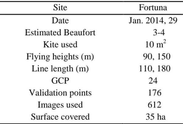
Table 1. Data collection information Site Fortuna Date Estimated Beaufort Kite used Flying heights (m) Line length (m) GCP Validation points Images used Surface covered Jan. 2014, 29 3-4 10 m2 90, 150 110, 180 24 176 612 35 ha 2.1. Image acquisition
During a one day mission on January 29th, 2014, a zone of 35 hectares including fours gullies on the site of Fortuna has been flown over. The flight was carried out with a 10 m2 kite and more than 1500 images were acquired during approximately three hours of flight. The objective was to obtain an orthophotography and a digital elevation model having decimetric accuracy. The flight parameters have been determined according to the desired ground resolution of 5 cm. Image acquisition was carried out using a camera attached to a kite following the method detailed in Feurer et al., 2015. The camera is a Sony NEX-5N, equipped with an 18mm objective and a 23.5 * 15.6 mm sensor. Wind conditions of the acquisition day have led to choose the delta wing of 10 m2. To have a ground pixel of 5 cm, camera had to be placed at an altitude of 190 m. As described with more details in Feurer et al. 2015, flight altitude is controlled by the kite line length. The flight was carried out in two times, with a first pass at half altitude, attained by unrolling 110 m of wire and a second passage to the target resolution with 230 m of wire. Moreover, in order to guarantee a longitudinal recovery of 90% for acquisition, the time interval between two images was set up at 5 seconds. At the end of the flight, images are
2.2. Field surveying
In order to validate the elevation data estimated by the photogrammetric method, topographic data were collected with a TOPCON-GR3 differential GPS RTK. The manufacturer’s specifications give an accuracy of 1 cm and 1.5 cm, for both planimetric and altimetric accuracy respectively. However, field measurements carried out on fixed points showed a standard deviation of the error which falls within 3cm for both planimetric and altimetric estimations. They were 24 ground control points (GCP) and 176 check points well distributed on the site having been measured. The choice of GCPs has been done a posteriori on kite images. They have been chosen on rocks to ensure that they do not change and so identified unambiguously both on field and images. For each selected point, two types of image prints were established: one in A4 format to identify the point surroundings on the ground (full picture of the zone) and one in A3 format at full image resolution to precisely positioning the point on the rock.
2.3. Data processing
Three-dimensional information is computed from 2D images following four steps: (I) identification of key points and their matching in the different images, (ii) estimation of camera orientations and positions as well as its internal geometry by an iterative bundle block adjustement, (iii) dense matching at the pixel scale for the calculation of elevation and individual orthophotos and (iv) mosaicking of individual orthophotographies with radiometric equalization.
Several fully automated softwares are available, which present a good solution for many
applications. Compared to conventional
photogrammetric techniques, they show shortages on measuring accuracy (Pierrot Deseilligny and Clery, 2011; Rosnell and Honkavaara, 2012; Stöcker et al., 2015). APERO/MICMAC software
(Pierrot-Deseilligny and Paparoditis, 2006;
After bundle adjustment and compensation between homologous points and (GCPs), the residuals of GPCs and validation points were used to assess the results accuracy and the absolute orientation. Here, all the points (control and validation) were considered separately and the mean square errors (RMSEs) were calculated. Firstly, we started with a quantitative assessment
of the topographic data produced by
photogrammetric method in comparison with the ground data (validation and check-points). The altimetric error of restitution is estimated by calculating the difference between values of the
altitude restored by photogrammetry and
measured by differential GPS RTK respectively. We evaluated the DEM altimetric quality by calculating the average error of altitude and the standard deviation as shown by Table 2 and figure 3. Secondly, we calculated the altimetric residual errors by comparing the measured positions of all the points (GCPs and validation) with their positions traced on the orthophotography and DEM (figure 2 and Table 2).
Moreover, the altitude estimation errors were determined by the difference in DSM altitude and
ground altitude, with negative errors indicating an underestimation of altitude and positive errors associated with an overestimation (figure 4). Non-random spatial patterns of the errors (figures 4) suggest that some parameters are still miss-estimated. In particular, a doming effect on the Fortuna test site might be attributed to residual lens distortion effects, such as the ones studied by James and Robson (2014). Since the camera is a consumer grade digital camera, it is necessary to estimate its distortion model accurately when it is used for measurement to avoid the doming effect. Table 2. Error statistics
Site Fortuna Mean (m) Standard deviation (m) Sample size Pixel size (m) +0.04 +0.07 176 0.062 Figure 4: DEM error distribution
M.A. El Maaoui et al. 2015
4. Conclusion
In this study we assessed the accuracy of the topography altimetric restitution of a strongly gullied zone covering 35 hectares. High-resolution aerial photography are taken by kite platform. DEM accuracy assessment shows the utility of this remote sensing technique to estimate the topography altitude with a precision which answers the gullying problems (monitoring and
quantifying volumetric soil loss). Stereo
photographs should allow stereoscopic
interpretation of gully morphology and erosion processes. They can be employed for digital photogrammetric analysis and production of DEMs. This opens the way to a better soil loss volume quantification. But we need to investigate photogrammetric fundamentals prerequisites for any metric reconstruction from images such as
camera calibration, image orientation and
measurement. In the case of kite-borne
acquisition, the altimetric accuracy is found to be approximately of the pixel size and the precision better than the ground sampling distance. Aerial kite photography provided excellent alternatives to more traditional techniques in monitoring and calculating gully erosion rates and volumes. In this respect, structure from motion software for images, acquired by consumer grade digital camera, processing could be considered as an advantageous alternative to conventional aerial photography processing. The method affordably
increases photo resolution and improves
flexibility, rapidity and site specificity in very fine detail.
Acknowledgements
This research work is supported by the research unit of the “National Engineering School of Tunis”.
References
Bogacki, M., M. Giersz, P. Przadka-Giersz, W. Malkowski, and K. Misiewicz, 2010, GPS RTK Mapping, Kite Aerial Photogrammetry, Geophysical Survey and GIS Based Analysis of Surface Artifact Distribution at the pre-Hispanic site of the Castillo de Huarmey,
North Coast of Peru: Proceedings of 30th EARSeL Symposium: Remote Sensing for Science, Education and Culture, p. 121-130. Colomina, I., and P. Molina, 2014, Unmanned
aerial systems for photogrammetry and remote sensing: A review: ISPRS Journal of Photogrammetry and Remote Sensing, v. 92, p. 79-97.
El Maaoui, M. A., M. S. Felfoul, M. R. Boussema, and M. H. Snane, 2012, Sediment yield from irregularly shaped gullies located on the Fortuna lithologic formation in semi-arid area of Tunisia: Catena, v. 93, p. 97-104. Feurer, D., M. A. El Maaoui, O. Planchon, M. R.
Boussema, and M. Pierrot-Deseilligny, 2015, Kite-borne photogrammetry for decimetric 3D mapping of several square kilometres areas: Geoscience and Remote Sensing Symposium (IGARSS), 2015 IEEE International, p. 3858-3861.
Fonstad, M. A., J. T. Dietrich, B. C. Courville, J. L. Jensen, and P. E. Carbonneau, 2013, Topographic structure from motion: a new
development in photogrammetric
measurement: Earth Surface Processes and Landforms, v. 38, p. 421-430.
Frankl, A., J. Poesen, N. Scholiers, M. Jacob, M. Haile, J. Deckers, and J. Nyssen, 2013, Factors controlling the morphology and volume (V)-length (L) relations of permanent gullies in the northern Ethiopian Highlands: Earth Surface Processes and Landforms, v. 38, p. 1672-1684. Georgantas, A., M. Brédif, and M. Pierrot-Desseilligny, 2012, An accuracy assessment of automated photogrammetric techniques for 3D modeling of complex interiors: Proceedings of the XXII ISPRS congress on international archives of the photogrammetry, remote sensing and spatial information sciences, p. B3.
Gimenez, R., I. Marzolff, M. A. Campo, M. Seeger, J. B. Ries, J. Casali, and J. Alvarez-Mozos, 2009, Accuracy of high-resolution photogrammetric measurements of gullies with
contrasting morphology: Earth Surface
Processes and Landforms, v. 34, p. 1915-1926. James, M., and S. Robson, 2012, Straightforward
James, M. R., and S. Robson, 2014, Mitigating systematic error in topographic models derived from UAV and ground‐based image networks: Earth Surface Processes and Landforms, v. 39, p. 1413-1420.
Lowe, D. G., 2004, Distinctive image features from scale-invariant keypoints: International journal of computer vision, v. 60, p. 91-110. Martinez-Casasnovas, J. A., M. C. Ramos, and J.
Poesen, 2004, Assessment of sidewall erosion in large gullies using multi-temporal DEMs
and logistic regression analysis:
Geomorphology, v. 58, p. 305-321.
Marzolff, I., and J. Poesen, 2009, The potential of 3D gully monitoring with GIS using high-resolution aerial photography and a digital photogrammetry system: Geomorphology, v. 111, p. 48-60.
Marzolff, I., J. Ries, and K.-D. Albert, 2002, Kite aerial photography for gully monitoring in sahelian landscapes: Proceedings of the Second Workshop of the EARSeL Special Interest Group on Remote Sensing for Developing Countries, p. 20.
Oleire-Oltmanns, S., I. Marzolff, K. Peter, and J. Ries, 2012, Unmanned Aerial Vehicle (UAV) for Monitoring Soil Erosion in Morocco: Remote Sensing, v. 4, p. 3390-3416.
Parkner, T., M. J. Page, T. Marutani, and N. A. Trustrum, 2006, Development and controlling factors of gullies and gully complexes, East Coast, New Zealand: Earth Surface Processes and Landforms, v. 31, p. 187-199.
Pierrot-Deseilligny, M., and N. Paparoditis, 2006, A multiresolution and optimization-based image matching approach: An application to surface reconstruction from SPOT5-HRS stereo imagery: International Archives of Photogrammetry, Remote Sensing and Spatial Information Sciences, v. 36, p. w41.
Pierrot Deseilligny, M., and I. Clery, 2011, Apero, an open source bundle adjusment software for automatic calibration and orientation of set of images: ISPRS-International Archives of the
generation from aerial image data acquired by a quadrocopter type micro unmanned aerial vehicle and a digital still camera: Sensors, v. 12, p. 453-480.
Smith, M. J., J. Chandler, and J. Rose, 2009, High spatial resolution data acquisition for the geosciences: kite aerial photography: Earth Surface Processes and Landforms, v. 34, p. 155.
Stöcker, C., A. Eltner, and P. Karrasch, 2015, Measuring gullies by synergetic application of UAV and close range photogrammetry—A case study from Andalusia, Spain: Catena, v. 132, p. 1-11.
Tamene, L., S. J. Park, R. Dikau, and P. L. G. Vlek, 2006, Analysis of factors determining sediment yield variability in the highlands of northern Ethiopia: Geomorphology, v. 76, p. 76-91.
Thompson, C. J., J. Croke, R. Ogden, and P.
Wallbrink, 2006, A morpho-statistical
classification of mountain stream reach types in southeastern Australia: Geomorphology, v. 81, p. 43-65.
Vedaldi, A., 2011, SIFT++ A lightweight C++ implementation of SIFT.
Verhoeven, G. J., 2009, Providing an
archaeological bird's‐eye view–an overall picture of ground‐based means to execute low‐altitude aerial photography (LAAP) in Archaeology: Archaeological Prospection, v. 16, p. 233-249.