HAL Id: hal-01533067
https://hal.archives-ouvertes.fr/hal-01533067
Submitted on 5 Jun 2017
HAL is a multi-disciplinary open access
archive for the deposit and dissemination of
sci-entific research documents, whether they are
pub-lished or not. The documents may come from
teaching and research institutions in France or
abroad, or from public or private research centers.
L’archive ouverte pluridisciplinaire HAL, est
destinée au dépôt et à la diffusion de documents
scientifiques de niveau recherche, publiés ou non,
émanant des établissements d’enseignement et de
recherche français ou étrangers, des laboratoires
publics ou privés.
Open source tools for locomotion and apprehension of
space by visually impaired persons: some propositions to
build a prototype based on Arduino, speech recognition
and OpenStreetMap
Said Boularouk, Didier Josselin, Eitan Altman
To cite this version:
Said Boularouk, Didier Josselin, Eitan Altman. Open source tools for locomotion and apprehension of
space by visually impaired persons: some propositions to build a prototype based on Arduino, speech
recognition and OpenStreetMap. Societal Geo-Innovation, May 2017, Wageningen, Netherlands.
�hal-01533067�
based on Arduino, speech recognition and OpenStreetMap
Said Boularouk,Université d’Avignon, LIA Avignon, France said.boularouk@univ-avignon.fr Didier Josselin UMR ESPACE 7300, CNRS Avignon, France didier.josselin@univ-avignon.fr Eitan Altman INRIA Sophia-Antipolis, France Eitan.Altman@inria.fr Abstract
In this article, we discuss about the benefit of IoT for people with disabilities, particularly for visually impaired and blind people mobility. We propose a simple prototype using OpenStreetMap data combined to physical environment data measured from sensors connected to a Arduino board through Speech recognition.
Keywords: blind people, usability test, Iot, Arduino, Voice recognition, OpenStreetMap, Open Source.
1
Context
1.1 Internet of Things
The internet of things (IoT) enables and improves the con-nection between people and things that surround them. Due to its wide applicability, this technology promises sig-nificant benefits in the lives of human beings. There is consequently a risk that the IoT technology will prioritize the technical artefacts (things) and will neglect the social aspects of its technical systems and information infras-tructures (Crump and Brown 2013). Beyond connectivity, IoT has the capability of embedding intelligent behaviour of connected sensors. Thus, the adjective "smart" is often seen in IoT references (Neisse et al. 2014).
Emergence of the Internet of things (IoT) is indeed im-pacting our lives. We hear more and more about new smart objects on the market. The motivations of pro-fessionals working in this field are often economic and IoT covers a wide area of applications: preserving envi-ronment, reducing energy consumption, domestic tools, games, durable goods, multipurpose drones, monitoring, etc. The projections for the impact of IoT on the econ-omy is monumental, with some anticipation of $11 tril-lion by 2025 (Rose, Eldridge, and Chapin 2015). IoT also promises to be beneficial for people with disabilities. It may improve quality of life and level of independence.
During their locomotion, visually impaired persons need human assistance or other visual compensation tools. On the one hand to avoid obstacles, on another hand to com-prehend space (Boularouk, Josselin, and Altman 2016). The evolution of Internet of things and the success of the crowd-sourcing map platform (e.g. OpenStreetMap) may improve the daily life of visually impaired persons by giv-ing them information about surroundgiv-ing space.
In this paper, we present a simple experience to combine free open-source spatial data (OpenStreetMap) with an open-source electronic platform (Arduino) used in many other applications IoT-oriented like GPS indoor
applica-tions (Vorst et al. 2008; Kolaskar et al. 2016) or domotic applications (Kumar Rath 2013). Visually impaired peo-ple can thus communicate using machines through a vo-cal Human-Machine Interface (HMI) based on the .NET Speech Recognition & Text Synthesis API.
1.2 Blind people in their environment
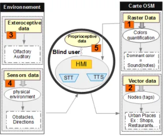
According to Gibson, the way how a knowledge is acquired is not of major importance: there is no difference in the cognitive functioning of the blind compared to other peo-ple. Gibson demonstrated that a human reacts in rela-tion to the close environment (affordances) (Virole 2009). Since development of spatial representation depends more on cognitive than on perceptual processes (Hatwell 2003), we propose in this paper to help people to compensate vi-sual perception. This system (fig: 1) can give a dual help: earning map by auditory perception, avoiding obstacles using sensors.
The extension of the concept of affordance to language allows us to understand that perception is fundamentally oriented towards the search of meaning. Understanding a word is, first of all, understanding the meaning it refers to. Likewise, a heard sound is meaningful since it corre-sponds to an adaptation of an object to its environment ("naturalistic orientation language" Virole 2009).
The visual perception allow to access, in a direct and fast way, to many spatial properties and features of the environment. However, Vision is a powerful spatial per-ception. Due to a lack of vision, blind people search in-formation from other stimulus:
• Hearing information helps to identify the nature of objects. However, many objects do not emit sound; • Proprioceptive information for position of the various
body segments in relation to each other and with the surrounding space;
• Tactile information: touch, perception of contact is very limited even if it can be enlarged by exploration
AGILE 2017 - Wegeningen, May 9-12, 2017
movements; it enriches mental maps;
• Olfactory information: smell is the meaning to ana-lyze volatile chemicals (odors) present in the air. In this paper, we mainly focus on hearing information using auditory transcription and speech recognition.
1.3 Connected systems for blind people loco-motion
In order to regulate the interaction between blind users, geographical database and sensors, we use Speech recogni-tion and Synthesis. The HMI (fig: 2) was built for desktop use and we are now working on an embedded application for android (not presented in this paper). Environment is comprehended by the blind people using exteroceptive data (auditory) and data from sensors (obstacles and ori-entation). The system is based on the OSM geographical data base, including raster and vector data.
Figure 1: Global solution for visual compensation
2
Auditory transcription of spatial data
Here we shortly present some aspects of the relation be-tween sounds, voice and spatial data.
2.1 Sonorous raster maps
The main goal of raster «sonification» is to convert map colors to sounds close in meaning (Josselin et al. 2016). It is impossible to make a direct correspondence between sounds and colors: there is no overlap between the fre-quency ranges of the sounds audible by the human ear (20 to 20 KHz) and the light visible by eyes (waves from 400 to 800 THz). A few works dealt with sonorous maps semiotic (Krygier 1994; Jouhaneau 2013), but they con-cluded that joining images and sound or music still needs major improvements, especially to associate sounds and memory capability.
In fact, auditory stimuli are not interesting as long as a relation between the heard sound and its source cannot be established. It is however possible to convert colors of map legend to sounds from nature (”soundscape”), under condition that both sound and color represent the same thing. For instance, we can represent the blue color of a sea by sounds of sea, green color by sounds of nature, etc.
2.2 Voice reading of OSM vector data
OSM Data is collected at a fine granularity as contributors tend to describe their place of daily life. However, with important flux of data, verification and validation of the data produced is not easy because of means (time, human resources) (Hombiat, Villanova-Oliver, and Gensel 2015).
Figure 2: HMI worfklow
Indeed, there are two problems: syntactic heterogene-ity and semantic heterogeneheterogene-ity. That is why we propose a spatial ontology (Vangenot 2004) for voice transcription of OpenStreetMap data for visually impaired people. To solve syntactic heterogeneity, we transfer all data, includ-ing data collected via sensors, to a database (in our HMI, we use Mysql). To solve semantic heterogeneity, we build a taxonomy based on the most visited places and taginfo and we exploit statistics to define our queries. We use also Google API translator to assure similarity between human language and English key words.
3
Components of the system
In addition to blind users perception, we propose elec-tronic sensors for obstacle detection.
3.1 Arduino board
To process the orientation during the user motion, we use an Arduino electronic board (fig: 3) and a 3-Axis Digi-tal Compass HMC5883L, a sensor to detect cardinal di-rections. This board is related to the computer or the smartphone.
3.2 A sensor for cardinal directions
A program was developed with C# (.NET) to locate ur-ban places and their details (name, address). It
calcu-Figure 3: Cardinal direction sensor with arduino nano
lates the distance between two locations using their lat-itudes and their longlat-itudes, using the Haversine formula (Boularouk, Josselin, and Altman 2016).
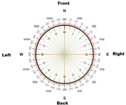
This function can tell the blind user where the place he is looking for is located, within the 4, 8 or 16 cardinal di-rections, which is not really helpful to comprehend space. So this must be change in relative directions.
The 3 axis digital compass sensor (fig:3) helps the user to detect the correct orientation and calculates the correct bearing. With a simple code (cf ??), the cardinal direc-tion will provide a more accurate interpretadirec-tion of space. Thus, HMI program will situate place in "Left", "Right", "Front", "Back" of the user (cf 4).
Figure 4: Direction using Arduino: compass
3.3 Obstacle detection
On the one hand, several systems exist to help blind peo-ple to move. Those can be based on GPS or beacons. Elec-tronic tools are sometimes used to detect obstacles from different companies (Cbel, Visioprtonic, Ultracanne, etc.). Those can be electronic canes using sounds or vibrations, or connected glasses (augmented reality with NuEyes, ob-jects or face recognition with MyEyes systems). OrCAM also developed a system with a camera (3.000 € each), as eSight (13.000 €). Most of those electronic devices are very expensive and only a few blind people can af-ford them. Research programs were funded and devel-oped mostly, for instance about indoor electronic canes
(Range-it in 2015, I-cane in 2007) or tactile cognitive maps (Blindpad in 2016).
On the other hand, many sensors exist to detect and to avoid obstacles (ultrasounds sensor, laser sensor, infrared sensor, Doppler sensor, etc., cf. 5). They are all cheap but they need some algorithms for more accuracy. Connect-ing obstacles detection sensors to smart phone for visually impaired persons helps to avoid dangerous zones. In par-allel, data from OpenStreetMap can guide the user during his motion, using voice recognition. For instance there ex-ists an on-line OSM application OSM for the Blind which allows to identify specific urban street furniture or paths. Much interesting research were developed on improving visually impaired people assistance using different input and output technologies (Kibum and Xiangshi 2014), such as sensory substitution devices (Hamilton-Fletcher et al. 2016, Carcedo et al. 2016), software on smartphones for object recognition (Manduchi and M. Coughlan 2014), haptic systems (Tanaka and Parkinson 2016), wearable systems (Ye et al. 2014) or dedicated interfaces for map-ping (Ducasse et al. 2016). An overview of current status and challenges such as sensor-based assistive devices for visually impaired people can be found in Elmannai and Khaled 2017.
Figure 5: Detecting obstacle and direction using ultra-sound and 3 axis sensors
3.4 An adapted vocal local gateway
There are many models for communication for IoT Tech-nology. Their choice depends on the application. The device-to-application-layer gateway (ALG) model is fre-quently used in popular smart devices models (fitness, tracking, personal security...). These devices do not have the native ability to be directly connected to a cloud ser-vice, so they frequently rely on smartphone to serve as an intermediary gateway to connect to the cloud (Rose, Eldridge, and Chapin 2015). In general, users directly in-teract with smartphone. In the case of blind people, we need to replace the screen by another way of interaction. In such a need, voice recognition and text synthesis can play a major role (Boularouk, Josselin, and Altman 2016, cf. Figure 6).
AGILE 2017 - Wegeningen, May 9-12, 2017
4
Conclusion and perspective about IoT
technologies for blind people
The internet of Things became an important topic in econ-omy, industry, research, policy, and has become very pop-ular thanks to the media:
• Cisco IBSG (Rose, Eldridge, and Chapin 2015) pre-dicts there will be 25 billions of devices connected to the Internet by 2015;
• the global IoT market will be $14.4T by 2022; • IC Insights predicts a revenue from Industrial
Inter-net IoT spending will increase from $6.4B in 2012 to $12.4B in 2015.
• The size of the IoT in manufacturing market is es-timated to grow from $4.11B in 2015 to $13.49B by 2020, attaining a CAGR1of 26.9%2
In this concept, objects are combined using internet connectivity. New applications can be developed by the integration of physical and digital worlds, (Neisse et al. 2014), to remedy to problems that stifle the development of this promising technology. Despite rapid technological developments in many areas (health, business, energy, se-curity), research on the social impact of the IoT is still quite sparse (Crump and Brown 2013). Research commu-nity is investigating security and privacy aspects and is constantly developing appropriate solutions for IoT: the cloud for bulk data flow, 6LowPAN for energy consump-tion, 6IPv for internet congesconsump-tion, etc.
A variety of approaches to intelligent Smart robot inter-faces were proposed (Böhme et al. 2003), but most of them concern multi-modal concepts where vision and acoustic have an important role. Since apprehension of space de-pends on cognitive ability and not on mode of perception, is is possible to use only auditory perception to interact with visually impaired people. A data mining process is needed to extract data from OSM maps. An ontology is also required to construct a rhetoric and constrictive di-alog between visually impaired person and the machine (computer, Smart phone). In this article, we proposed a solution to the particular case of the blind persons. We believe that Iot may improve integration of the persons suffering from visual deficiency in society. IoT can ensure security of blinds in their mobility and help them to better apprehend their environment.
References
Böhme, Hans-Joachim et al. (2003). “An approach to multi-modal human–machine interaction for intelligent service robots”. In: Robotics and Autonomous Systems. Best Papers of the Eurobot ’01 Workshop 44, pp. 83– 96. issn: 0921-8890.
1Compound Annual Growth Rate
2
http://www.forbes.com/sites/louiscolumbus/2015/12/27/roundup- of-internet-of-things-forecasts-and-market-estimates-2015/#6d00e78a48a0
Figure 6: Connected objects for the compensation of visual deficiency
Boularouk, Said, Didier Josselin, and Eitan Altman (2016). “Interaction Homme Machine pour l’orientation spatiale des malvoyants”. In: Colloque International de Géomatique et d’Analyse Spatiale (SAGEO 2016), Dec 2016, Nice, France. 2015.
Carcedo, Marta G. et al. (2016). “HaptiColor: Interpolat-ing Color Information as Haptic Feedback to Assist the Colorblind”. In: CHI’16, May 07 - 12, 2016, San Jose, CA, USA.
Crump, Jeremy and Ian Brown (2013). The Societal Im-pact of the Internet of Things.
Ducasse, Julie et al. (2016). “Tangible Reels: Construction and Exploration of Tangible Maps by Visually Impaired Users”. In: CHI’16, May 07 - 12, 2016, San Jose, CA, USA.
Elmannai, Wafa and Elleithy Khaled (2017). “Sensor-Based Assistive Devices for Visually-Impaired People: Current Status, Challenges, and Future Directions”. In: Sensors17,565.
Hamilton-Fletcher, Giles et al. (2016). ““I Always Wanted to See the Night Sky”: Blind User Preferences for Sen-sory Substitution Devices”. In: CHI’16, May 07-12, 2016, San Jose, CA, USA.
Hatwell, Yvette (2003). “Le développement perceptivo-moteur de l’enfant aveugle”. In: Enfance 55, p. 88. issn: 0013-7545, 1969-6981.
Hombiat, Anthony, Marlène Villanova-Oliver, and Jérôme Gensel (2015). “Un nouveau méta-modèle pour rap-procher la folksonomie et l’ontologie d’OSM”. In: Col-loque International de Géomatique et d’Analyse Spatiale (SAGEO 2015), Nov 2015, Hammamet, Tunisia. 2015. Josselin, Didier et al. (2016). “Sonorous Cartography for Sighted and Blind People”. In: Proceeding of AG-ILE’2016, Helsinki, 14-17 June, 2016.
Jouhaneau, Jacques (2013). “Perception de l’espace et immersion - perception auditive”. In: Techniques de l’ingénieur.
Kibum, Kim and Ren Xiangshi (2014). “Assisting Visu-ally Impaired People to Acquire Targets on a Large Wall-Mounted Display”. In: Journal of Computer Sci-ence and Technology29(5), pp. 825–836.
Kolaskar, Mangesh et al. (2016). “Real Time and Offline GPS Tracker Using Arduino”. In: vol. Vol -2, Issue- 5, 2016. isbn: 2454-1362.
Krygier, J. (1994). “Sound and Geographic Visualiza-tion”. In: Visualization in Modern Cartography Alan MacEachren and D.R.F. Taylor (eds.). Pp. 149–166. Kumar Rath, Deepak (2013). “Arduino Based: Smart
Light Control System”. In: International Journal of En-gineering Research and General Science4(2). issn: 2091 - 2730.
Manduchi, Roberto and James M. Coughlan (2014). “The Last Meter: Blind Visual Guidance to a Target”. In: CHI 2014, April 26–May 1, 2014, Toronto, Ontario, Canada.
Neisse, Ricardo et al. (2014). Internet of Things Applica-tions - From Research and Innovation to Market De-ployment. River Publishers, Niels Jernes Vej 10, 9220 Aalborg Ø, Denmark. Dynamic Context-Aware Scalable and Trust-based IoT Security, Privacy Framework. Dr. Ovidiu Vermesan, Dr. Peter Friess.
Rose, Karen, Scott Eldridge, and Lyman Chapin (2015). “The Internet of Things: An Overview”. In: Internet Society.
Tanaka, Atau and Adam Parkinson (2016). “Haptic Wave: A Cross-Modal Interface for Visually Impaired Audio Producers”. In: CHI’16, May 07–12, 2016, San Jose, CA, USA.
Vangenot, Christèle (2004). Les ontologies spatiales. Lavoisier, Paris, Revue Internationale de Géomatique, Volume 14 N° 2/2004.
Virole, Benoit (2009). Surdité et sciences humaines. Vol. chapitre 8. L’Harmattan.
Vorst, Philipp et al. (2008). “Indoor Positioning via Three Different RF Technologies”. In: Computer Science De-partment, University of Tübingen, Tübingen, Germany. Ye, Hanlu et al. (2014). “Current and Future Mobile and Wearable Device Use by People With Visual Impair-ments”. In: CHI 2014, April 26–May 1, 2014, Toronto, Ontario, Canada.