HAL Id: halshs-01157514
https://halshs.archives-ouvertes.fr/halshs-01157514
Submitted on 1 Jun 2015
HAL is a multi-disciplinary open access
archive for the deposit and dissemination of sci-entific research documents, whether they are pub-lished or not. The documents may come from teaching and research institutions in France or abroad, or from public or private research centers.
L’archive ouverte pluridisciplinaire HAL, est destinée au dépôt et à la diffusion de documents scientifiques de niveau recherche, publiés ou non, émanant des établissements d’enseignement et de recherche français ou étrangers, des laboratoires publics ou privés.
Mobile and Fatal: The EU Borders
Nicolas Lambert, Olivier Clochard
To cite this version:
Nicolas Lambert, Olivier Clochard. Mobile and Fatal: The EU Borders. Borderities and the Politics of Contemporary Mobile Borders, 2015, 9781137468840. �halshs-01157514�
Chapter 7 – Mobile and fatal: The EU borders
Nicolas LAMBERT
CNRS – UMS RIATE
Olivier CLOCHARD
MIGRINTER, Poitiers, France
The tragedy of October 3, 2013, off the coast of Lampedusa (Italy), in which 306 men, women and children died while fleeing countries devastated by war or dictatorships (Eritrea, Ethiopia and Somalia, among others) in search of a better life, reminds us of the cruel fate that has confronted tens of thousands of migrants each year – for the past two decades – in the Mediterranean region. However, few can remember the case of the 19-year-old Afghan migrant found dead August 13, 2012, on the banks of the Evros (the river on the border between Greece and Turkey) in the region of Marasiai, or the 22 Africans who fell overboard from their boat during heavy winds off the coast
of Almeriaii in the south of Spain. The European Union and its member states with their
warmongering practices are among those who are primarily responsible for such disasters that have led to the deaths of thousands of people in the Mediterranean Sea. However, in the Mediterranean region and beyond, the violence in a majority of cases leads to deaths, without there being any contact between the respective authorities responsible for border controls and their victims. Far from being a linear border that would separate an inside from an outside, this ‘migratory border’ is, by contrast, vague, mobile, reticular and asymmetrical. This is far more than an institutional separation between sovereign territories: What is under construction here is an intrinsically (geo)political border marked by the dominant relations between states and imposed by the EU on its
neighbors.
Since the establishment of the Schengen Area in the 1990s, European migratory policy has been guided by a willingness to control and stop foreigners who do not have valid travel or residential visas, and by the fight against terrorismiii. Since 2002, cooperation between member states aiming to
develop and strengthen controls at external borders has strengthened and gathered speed. In its communication from May 2002 titled Towards an integrated management of the external borders of
the Member States of the European Union, the European Commission laid out some of the
fundamental requirements of this policy ‘to possess the means of combating terrorism, guarantee a higher level of security inside the EU after enlargement (…) and increase the effectiveness of the fight against illegal immigration while respecting the principles of the right to asylum.’ This resolve of member states gave way to a number of new provisions that were subsequently put into place, namely a plurality of migratory control methods that exemplify the multiple borders of the Mediterranean.
In 2004, the immigration liaison officers’ networkiv, which participates in the enactment of
European migratory policy in the countries neighboring the EU and beyond, was put into place; since 2005, Frontex (the European Agency for the management of operational cooperation at the external borders of the member states of the European Union) uses radar, thermal imaging cameras, ships, helicopters, planes and will soon use drones, too, from the Strait of Gibraltar to Cyprus via the Greek islands in the Aegean Sea. From 2011, Eurosur, a coordinated surveillance system, relies on innovative technology to militarize the external borders of the EU and thus limit the number of ‘illegal’ immigrants from entering. These different provisions produce complex assemblages (Allen & Cochrane, 2010) and are consequently marked by a constant evolution that gives the impression of ‘migratory borders’ that are constantly moving and reconstructing themselves.
questions concerning the people who die in the process of migration, and to see how these border controls are responsible – either directly or indirectly – for the deaths of migrants at the borders and how they influence the displacement of these tragedies. This article will also present the advantages of a quantitative approach, which is made possible by the clustering of these situations in the Mediterranean Sea. This approach allows the creation of brand-new cartographic representations of what can call be referred to as a ‘border hotspot’ in order to give a new perception of this border, not to be seen as a limit between two territories but rather as a space between these two zones: a completely separate space where personal stories and tragedies occur. The article is original in that it bases its analysis on the social, political and spatial interaction surrounding the maritime area over which the borders of the Mediterranean Sea stretch out, giving it an unprecedented complexity.
1. The fluctuating and restrictive aspects of European border regimes
1.1 The expansion of border zones under the impetus of international agreements
With the signing of multiple international agreements between the EU’s member states and its neighboring countries, which seek to return or drive back ‘illegal’ immigrants, the relocation of border controls has been strengthened considerably. These agreements can be bilateral (such as Spain-Morocco, Italy-Libya) or include the entire European community. Since 2002, the Justice and Home Affairs Council (JHA) has made it one its priorities to establish readmission agreements with those countries that share a border with the EU and also with those from where there are a large number of migrants (Morocco, Turkey) into the union. There is also the European Neighbourhood Policy (ENP), where migration and border controls are two important topics. More ‘technical’ agreements, like those that the European agency Frontex has signed with countries such as Turkey or that they are trying to negotiate with countries such as Jordan, Egypt, Libya, Tunisia, Morocco, Mauritania and Senegal, underline the willingness of the EU to establish a buffer zone over the entire southern part of the Mediterranean region. Moreover, in its annual report from 2012, Frontex
emphasized that while the European Commission is primarily interested in creating a dialogue on migration, mobility and security with these countries, the agency ‘was active in developing contacts with the competent authorities of these countries and looking to initiate formal negotiations to conclude working arrangements where appropriate’v. Through these different issues relating to
European migratory controls operating in the countries of origin and to the transit of migrants, the mechanisms aimed at fighting ‘illegal immigration’ are based on a ‘plurality of actors in outposts who relate to a trend of leverage and invisibility of borders at the mercy of the deployment of controls’ (Blanchard, Clochard, & Rodier, 2010, p. 5). For example, Moroccan and Spanish police forces closely collaborate on surveillance in the Strait of Gibraltar, and return migrants to Morocco who have reached the sovereign territories of Ceuta and Melilla. Between May and September 2012, hundreds of migrants who had invaded these populated Spanish exclaves situated in close proximity to the Moroccan coastline, were deported to Morocco. On February 6, 2014, the Guardia
Civil and the Moroccan police fended off nearly 300 people of sub-Saharan origin who were trying
to reach the sovereign territory of Ceuta. ‘Some of these migrants jumped into the sea in order to try and reach the beach at Tarajal. At least 15 people drowned (…) others were declared missing’vi.
With this latest tragedy, the Spanish authorities reached a new level in the escalation of border controls by installing anti-climbing nets on the metal fences that surround Ceuta and Melillavii.
Political desire and the pressure on the European Union’s member states to control illegal immigrants are such that for roughly the past decade, it has implicitly ordered actions on the part of border control agencies that are sometimes irreversible. Several testimonies mention that the Greek coastguard could be responsible for the sinking of migrant boats in the Aegean Seaviii. It has also
been reported in the Spanish daily newspaper El Paísix that in April 2008, off the coast of Al Hoceima in the northeast of Morocco, Moroccan soldiers were alleged to have deliberately used a knife to puncture an inflatable dinghy that had 70 migrants onboard trying to reach Spain. Thirty-six of them were either declared missing or found dead.
1.2 Sea borders: contiguous zones …
Thus, migratory surveillance of member states takes place in numerous border regions where the work of the border control agencies is made easier by there being no one to stop the forced return of migrants. If some of these actions by border forces took place in the middle of a desert like in Morocco, to the south of Oujda, or at the Mauritanian border where migrants are abandoned and left by the Moroccan police, the sea borders are also the scene for forced returns that take place outside any legal framework. The United Nations Convention on the Law of the Sea (UNCLOS 1982), which came into force in 1994, affirms that coastal states have contiguous zones, which can cover an area up to 24 nautical miles from the coast (territorial waters plus contiguous zone), where the competent authorities have the right to repress any violation of their national legislation on immigration. Regardless of whether this contiguous zone is demarcated or not, in numerous cases the migratory controls take place well beyond the established 24 nautical miles.
In this regard, the surveillance operations that took place in international waters and were coordinated by Frontex raise multiple questions ‘regarding the compatibility between the operation of this agency with the respect of migrant’s rights and notably the right to asylum. For example, in June 2009, as part of an agency operation, the Italian coastguard, assisted by a German helicopter, intercepted 75 people aboard a small boat and then returned them to the Libyan authorities. Following this event, the assistant director of Frontex said the agency would not take responsibility for the risks faced by those people who are sent back, and it was not able confirm that their right to asylum and human rights were being respected in Libya’x. This event became the subject of a
complaint filed in the European Court of Human Rights (ECHR) that condemned Italy, in February 2012, for the violation of the principle of non-refoulementxi. Despite this decision, European
authorities continue their operations. This is proved by the story of migrants from Somalia held in the Toweisha camp near Tripoli in June 2012, who said that after five days of crossing the waters and they had nearly reached the coast of Malta, they were retrieved by some boats who handed
them over to the Libyan coastguard, which subsequently detained them in this camp. These practices violate the principle of non-refoulement set out by the Geneva Convention relating to the Status of Refugees, which prohibits the deportation of foreigners to a country where they risk being subjected to torture or other inhuman or degrading treatment or punishmentxii. The regulation on
maritime surveillance, adopted in the spring of 2014, is in the process of legitimizing these practices as the text makes reference to sending back migrants stopped in international waters.
1.3 … to the treatment of ‘illegal passengers’ aboard ships
In Europe, border crossings by foreigners without valid documents is being criminalized more and more, which means immigration is often associated with a criminal offensexiii. Consequently, for
around the past 30 years, European governments have developed laws aiming to legalize the detention of migrants. In 2011, the Migreuropxiv network took a census of nearly 420 detention
centers inside the EU and neighboring countries; however, there is also a multitude of areas that are often invisible and not featured on the map(Migreurop, 2011). The structures of these places are not clear and can be understood with great difficulty as they vary greatly. Also despite their different sizes, these situations can be perennial or temporary and sometimes even ‘mobile’.
For example, in August 2013, following an application from the Italian authorities, the Salami oil tanker, flying the Libyan flag, rescued 102 ‘boat people’ in distress 46.6 nautical miles off the coast of Libya and 140 nautical miles off the coast of Malta – the destination of the ship. However, at 24 nautical miles from its destination, the Maltese army ordered the tanker to stop and told the captain to return to the port of Khoms, situated 120 kilometers to the east of Tripoli, where the ship had come from and was the closest port to the rescue zone where the migrants could disembarkxv. ‘The
Captain refused and pressed Malta to receive these migrants and even the European Commission (EC) ordered Malta to let these people disembark from the ship in order to answer the humanitarian emergency in this situation’xvi. This is not an isolated case. In July 2013, Cecilia Malmström, the
European commissioner, had already highlighted her growing concerns regarding the comments made by the Maltese prime minister on the possibility of returning migrants who had recently arrived in Malta, and she also asked the Maltese authorities to take the necessary measures in order to respect the right to asylum and the principle of non-refoulementxvii. Several newspaper articles
have mentioned similar cases: On the same night of the August 4 and 5, 2013, a Turkish ship, Adakent, had to disembark 96 people in Tripolixviii. In May 2012, two merchant ships helped boat
people off the coast of Libya before disembarking them in Tripoli, following instructions from Rome.
There are also the cases of other ships, like those from Frontex or the Spanish navy under the banner of NATO: On July 11, 2011, the Almirante Juan de Borbón rescued over 100 ‘boat people’ of sub-Saharan origin, as well as some Tunisians and Libyans; however, they were not granted permission to disembark in Malta or Italyxix. Consequently, the people had to stay aboard for six
days, until a Tunisian military vessel took responsibility for them and they could disembark in Tunisia.
Hence, irrespective of the status of the ship that rescues these boat people, they often find themselves confined to the ship before being disembarked in neighboring countries such as Libya or Tunisia. Therefore after having assisted these people who were shipwrecked, the rescue boat plays a role in the detention and ultimately the violation of the principle of non-refoulement of asylum seekers. Therefore, is the ultimate ‘mobile border’ not bound by the measures put into place for the ships of the merchant navy?
1.4 Waiting areas (transit zones) at ports
In reference to waiting areas (transit zones) at European ports, we can observe the diversity of the layouts of border areas that occur over time so that border controls can be more effective and are
not challenged by the justice system when it has to intervene.
The legislation relating to the upkeep of waiting areas (transit zones) in France has continued to evolve over time. Today, there is a measure that is movable, namely a sort of resiliency of borders. Since its creation, in 1992, the waiting area (transit zone) has been limited to areas of disembarkation and areas where controls were operated and may have included buildings that provided ‘hotel type services’. The courts where the migrants were taken in order to extend their stay were not considered to be part of this waiting area (transit zone). There was a regular debate between the legislator, civil servants, judges and NGOs to establish whether these places were part or not of waiting areas (transit zones). In 2003, this controversy was settled by a law that explained that thenceforth, these waiting areas (transit zones) would ‘stretch, without there needing to be a particular decision, to the places in which the migrant must go either in the case of an ongoing legal process, either in the case of medical needs.’ The provisions introduced in 2011 strengthened this procedure and aimed to answer similar situations to the one that happened off the coast of Corsica in January 2010, when 123 Kurds were disembarked outside official border points. These areas can now be created ‘when it is obvious that a group of at least 10 migrants arrive in France outside a normal border crossing.’ As a result, these areas can now be created anywhere on the territory. These migrants who have just arrived in a specific territory can be in ‘the same place or in a group of distinct places within a 10-kilometer radius.’ The existence of these waiting areas (transit zones) is only temporary, as their maximum duration cannot exceed 26 days. Such a manipulation of the law for the purposes of migratory controls falls under the ‘delinearization’ process of state limits that started during the 1990s.
Regarding the controls themselves, even though there are laws that strive to prohibit the registration of ‘illegal passengers’ aboard ships, numerous examples (Migreurop, 2011) demonstrate that these practices still exist and lead to the deaths of migrants. One of the latest tragedies took place in January 2014 in Marseille. In order to avoid returning by boat, two Guineans jumped overboard
from the ship that had been detaining them for nearly a month, and one of them drowned. During their preceding stopovers (Antwerp in Belgium, Setúbal in Portugal and Genoa in Italy), port authorities had refused their disembarkation and registration of their asylum application.
‘The migratory border is (…) [therefore] extremely stretched and marginal; it will not stop evolving at the mercy of these different circumstances. For around the past 20 years, the borders of the so-called “rich” states have been transformed under the influence of international migratory flows, as a result of which they modified their installations and created new surveillance measures. Migratory barriers are no longer a unique external element of territories; today, they materialize through a series of obstacles that intersperse the path of those exiled in the search of a better life or of protection in a state other than their own’ (Blanchard E., Clochard O. & Rodier C., 2010, pp.6-7).
It is important to understand the dramatic consequences of the governance of the external limits of the EU, which is supported by more and more powerful technology. Even if it is difficult to understand the totality of this tragedy, cartography can be useful here.
2. A cartographic overview of these tragedies
The map showing the number of migrants that have died at Europe's borders was published in a large number of books, both scientific and press articles, and was also used in Web documentaries and films. It is used to remind us that what happens at the EU borders is not merely fatalities but the product of political intentions, namely to prevent men, women and children from accessing the territory of the European Union (EU). Even if this map has gained notoriety among campaigns and institutional networks, universities and even schools, it has not prompted deep change in European
migratory policy. It can also be used by some writers in a way that is contrary to its initial conception. How many times have we heard that it is important to reflect on new means of surveillance in order to avoid such tragedies? Consequently, the strengthening of border controls continues. Unfortunately, this has done little to reduce the number of tragedies in the Mediterranean Sea. We must also be mindful that the deadly borders of the European Union (EU) go much farther than only its external borders. The collaborations put into place between the EU, its member states and neighboring countries – Egypt, Libya, Tunisia, Algeria, Morocco, Mauritania and Senegal – push the police forces in these countries to commit criminal offences (see below) that often go unpunished.
So how can we project this European border via a map? As we have seen already, this cannot be summed up merely by tracing a simple line (like the Schengen Area, for example) that is supposedly protected by barriers and border guards. This migratory border, whose particularity is that it is for the most part maritime and materializes by measures that do not stop moving, cannot be represented by an official outline but rather via its practical aspect and the effects it produces. By a phenomenological approach, we will use different maps to show the tragic events that migratory controls lead to each year, namely the migrants (men, women and children) who have died at Europe's borders, and thus try to produce a new political and subjective outlook of Europe’s migratory border.
2.1 Maps used in the fight against deadly policies
- counting the number of deaths during migration
There is no official data concerning the number of migrants who have died at the borders of the European Union. However, via the press and other media, we know that among the thousands of people seeking asylum in Europe, who flee countries that are in crisis or because of war, some never
reach their destination. According to the European network UNITED for Intercultural Action, which has collected data from the press since 1993, the number of refugees, asylum seekers or migrants that have died trying to reach the EU borders has peaked at nearly 18,000 people. This database, which also contains the number of deaths following deportation, clearly shows a large progressive increase that peaked at nearly 2,000 deaths in 2011. At first sight, the different critical analyses of European migratory policy show that this evolution corresponds with a real increase that, however, is not devoid of statistical bias linked to growing attention by the media toward this issue. In fact, better media coverage has indisputably created a mediatized magnifying or probe effect that complicates the construction of relatively objective measures. By contrast, there are certainly situations that have not been able to be identified, such as those of the numerous migrants who died of dehydration in the Sahara. It is for this reason we are working here not on the evolution of this phenomenon but rather on the representation of the number of deaths since 1993. These figures represent only a small drop in the ocean compared with the bloodbath that should be at the heart of all policy.
Developed collectively from information that is difficult to locate with precision (many events took place at sea), the ‘géocodage’xx of the information, which is a prerequisite for the creation of these
maps, was not an easy task. The events collected by the press are often located either with precision or very approximately (for example, ‘in the desert’, or ‘between the Libyan coastline and Italy’), and we were therefore obligated to take certain precautions when processing this information. Nonetheless, the cartographic depiction of the events at Europe’s borders put forward in this article was designed to produce an overview of these events. The uncertainty surrounding localization will largely be compensated by a higher level of aggregation.
In 2003, the first map showing border deaths was published in Les cahiers d’Outre-mer(Clochard, 2003), then in 2004 and subsequent years it was distributed, incorporating more information, by Le
subsequently updated on several occasionsxxi. If the aggregated approach used by this map has the
disadvantage of dissolving individual stories into a global representation, these maps nonetheless have the advantage of producing an overview that allows the reader to comprehend where these events take place. Over the course of these updates, this map outlining the number of deaths was transformed in order to successively underline the different border crossings in Europe that are becoming more and more perilous and consequently more and more deadly. Thus, even if on the first maps that appeared in 2003 and 2004, the number of migrant deaths reached nearly 3,000 in the region of Gibraltar, successive updates have allowed us to observe a displacement of these tragedies toward the Canary Islands and then toward the central Mediterranean region, around Lampedusa and the Strait of Sicily. This map represents the information gathered for the period 1993–2012 and distinctly shows an aggregated vision of the three centers of activity. Moreover, by breaking down these events on the maps according to the cause of death, different circles, both large or small, distinguish between those people who drowned, committed suicide, suffocated, starved or froze to death, died in fires, or were poisoned. Ultimately, the map gives us a radical and dissenting image of European migratory policy, which is deemed to be responsible for this situation.
Other representations of this database have also been made. Some of the maps produced for Le
Monde diplomatiquexxii or in the framework of the European project ESPON Cartographic
Languagexxiii (Lambert, Ysebaert, & Zanin, 2013) pay particular attention to the subjective aspect of
cartographic representation by portraying the map not from a bird's eye view but rather from a migrant’s point of view. By orientating the projection of the map, which allows it to be shown at an angle so that gives the impression of observing Europe from Africa, the representation, thus devised, puts forward as many vast red circles as the insurmountable barriers erected by the European Union against migrants. However, even with these two examples, it remains a conventional cartographic representation based on classical mapping techniques and proportional circles. Other mapping techniques remain unexplored.
- Toward the production of an approach combining cartography and the study of migratory policies?
When Paul Ariès first used the term ‘degrowth’ (décroissance), he referred to it as a ‘mot obus’, or ‘bombshell word’. According to him, it is designed to question and to definitively enter into public debate this term that may be deemed shocking, but its sensational side forces each person to give their opinion. The term ‘degrowth’ (décroissance) is a sort of dissension, which was conceived in order ‘to pulverize the dominant way of thinking’ (Aries, 2004). Therefore, putting forward graphically and aesthetically an idea that is not neutral, the maps can also be ‘obus’ or bombshells; in fact, they are even designed for that. Reality is complex, plural and marked by contradictory interests; it cannot be mapped in its entirety. In order to carry its message, the map must make abstract but also summarize and caricature. By classing the information, enlarging some elements and keeping some quiet, as is done in the press, the geographical map is ultimately a discursive object that serves to construct a discussion. To create a map is to affirm a view, and it is this confrontation of different viewpoints that causes the debate. It is therefore necessary to put on the table the maps that can be considered an ‘obus’ in order to create a radical and dissenting cartographic overview of European migratory borders.
Using potential theory, a simple mathematical process allows us to calculate in any area the value of an absolute quantitative variable localized in its surroundings. By fixing the form and the range of these surroundings, we can produce a simplified and generalized image (Didelon, Grasland, & Richard, 2008) of this geographical phenomenon (Plumjeau et al., 2007). By varying the range of this function (adjustment/flattening of the Gaussian integral), we obtain a representation that is more or less ‘generalized’, allowing us to visualize at a single glance the large spatial structures and – in the zones that are of particular interest to us – the most devastating zones in this fight against migrants.
Moreover, the display of these maps in 3D allows the relevant gradients to be represented by gradients (slopes) that are more or less steep and cannot be understood on a map that is ‘flat’ (in 2D). The relief also helps us to understand the numbers represented, as the height allows us to see, at a single glance, the amplitude of the peaks, and consequently to compare them with each other. It is on this basis that we have built the following maps. By applying this to our database on the deaths at the EU borders, this process allows us to produce five levels of spreading the information that will be mapped on the following pages.
Figure 7.1 Cartographic generalization (potential method)
2.2 Cartographic metaphors or an effigy of a scattered reality?
A map is interesting insofar as it has something to say and is ‘eloquent.’ With the following maps, we will seek to tell a story – a cartographic narrative. Using press images, we want to make the different aspects of European migratory policy a reality by using these ‘cartographic metaphors’ and imbuing them with our imagination. In the same way a poignant novel can teach us as much about the real world as a rigorous and well-argued essay, we use metaphorical forms in order to see the true aspects of European migratory policy. It is a question of subjective and radical representations of the borders, but which are no less accurate than more conventional representations. Therefore, three cartographic accounts, created from the same data as the maps already presented above, will be presented below. Even if the first Schengen convention dates to 1985, the Schengen Area was progressively established during the mid-1990s and institutionalized at a European level by the Treaty of Amsterdam on October 2, 1997. It currently comprises 28 member states. According to the different European governments, the area of free movement inside the EU can only be tangible if Europe is able to effectively ‘protect’ its external borders. In order to ensure the longevity of this area of free movement and to reassure the member states, the Schengen Area was built on the drastic exclusion of foreigners who did not have the relevant authorization to enter or to live in this territory. European policy on visas – one of the first measures to be put into place – is characterized by a managerial and police-related approach to border control, which is based on the notion of ‘migratory risk’ (Migreurop, 2013).
The map below was developed in the following way: The method of using potential theory is stabilized by using one scale of 500 kilometers in order to produce a standardized image represented by red contour lines (isolines). We calculated the ridge line and then drew it in three dimensions with the help of a GIS (geographic information system). This line showing the
maximum mortality separating Europe and Africa was then extruded in order to constitute a fence rising up as a migratory ‘Iron Curtain’. This ‘classic’ symbolism that we also find in press drawings represents the defensive walls of a Europe that will protect itself at any cost against the hordes of migrants.
Even if this linear representation of the borders is in part a fantasy, it is no less true in certain areas. In fact, the policy of ‘securing borders’ led by the EU also appears in the construction of walls like in the case of Ceuta, Melilla, and in the region of Evros in Greece. Moreover, in areas of the eastern borders, much more sophisticated protective measures than those used during the Cold War have been put in place, notably in Estonia and Bulgaria. However, these walls are ineffective in the medium and long terms, and they mainly play a discursive role. According to Wendy Brown, they can even be considered as one of the symptoms of a decline in state sovereignty in a world that wants to be ‘more and more open’ (Brown, 2009).
Built where migratory tensions are at their highest, these walls are often disaster zones where human tragedy takes place. In 2005, a total of 17 migrants were shot dead in front of the walls that surround the Spanish exclaves of Ceuta (11 deaths) and Melilla (6 deaths). Hundreds of migrants were injured, and others were deported to the desert without any care or supplies. This wall of shame, which is also where Khady Demba dies in the story told by Marie Ndiaye in her book Three
Figure 7.2 Europe, the ‘fortress’
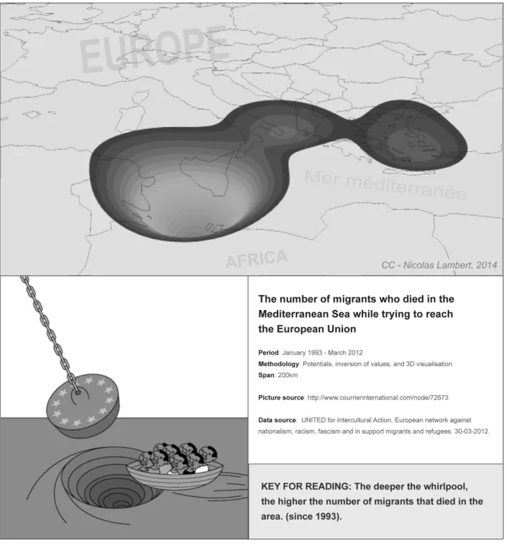
The migratory paths change, but the tragedies remain. An astute analysis of the database over time shows us that the strengthening of border controls set up by border control agencies and Frontex using nearly military-style measures does not contain these migratory flows but rather pushes them to use more dangerous routes. After Gibraltar and the Canary Islands, the most migrants now perish in the center of the Mediterranean.
enormous chasm in which over 6,000 migrants have drowned since 1993, in particular off the coast of Libya and Tunisia, and closer to Malta and Lampedusa. This Mediterranean whirlpool is a possible representation of the European ‘migratory border’. Far from the image of this ‘mère
méditerranée’xxiv described by Edgar Morin in 1995 as ‘a place where it is still possible to reinvent a
convivial economy’xxv; this maritime zone has become a storm zone and a cemetery for immigrants.
In May 2000, 32 refugees died after their ship was wrecked near Tangiers. The authorities did nothing to help them. In 2008, 36 Africans, including four babies, drowned after the Moroccan coastguard had punctured their inflatable dinghy with a knife.
Figure 7.3 The Mediterranean Whirlpool
‘Europe kills’ was the title of an article published in the newspaper Libération on October 4, 2013xxvi, written by the heads of different organizations that care for migrants and seek the defense
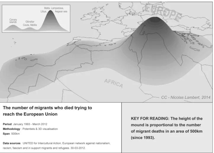
300 people. This tragedy could have been avoided, but Europe is locked in a war with migrants. The EU borders have become a battlefield, which is more than a simple front but is complicated and spread out. The setting up of a plethora of virtually military measures (planes, helicopter, speedboats, infrared detectors, etc.) – like those used by Frontex, and which fall under border control policy as well as annual budgetsxxvii allocated for the fight against illegal immigration – is
there to remind us of this fact.
By fixing the cartographic spread at 500 kilometers, we can see the creation of a mound whose summit is situated in the center of the Mediterranean region. This mound, red like the blood spilled in this area, is produced by the number of deaths of migrants trying to reach Europe. This representation by ‘geomorphology’ symbolizes the idea of an accumulation of years and years of forgotten victims of a war that we never hear about. This representation of a migratory bloodbath has reached a level that we could never measure with complete accuracy.
This red mound obviously makes reference to the bloody episode of the First World War (The Bapaume mound) that is taken from the famous anti-war song written by Montéhus. By extension, the migratory red mound is also an appeal to stop this invisible war against migrants.
Figure 7.4 The migratory red mound
Conclusion
In the framework of political and operational partnerships that the EU has established with its neighbors, it happens more and more that the union exports these border controls whose locations are constantly modified at the mercy of its needs. This externalization that falls within the external territories of the EU is equally consolidated by the presence of Frontex or the Eurosur system. There is also the fact that the European authorities are still not respecting the law of the sea and the decisions taken by the highest jurisdictions. These many points are well and truly the cause of the installation of these arbitrary lines and tragic situations. Thus, for more than the past 20 years, the Mediterranean Sea, such a beautiful natural object, has become lethal because of denied visas or the
absence of rescue services, although in some cases the authorities would have been informed of the situations if boat people found themselves in distress. Fernand Braudel wrote that the Mediterranean Sea was a ‘succession of seas’, and we can say that the Mediterranean Sea is not the same for everyone: There is one for tourists, one for transport and one as a borderxxviii, where several
hundreds of migrants drown to death each year during their crossings.
Just like press drawings, the map is an effective way of shedding light on these events. Without refuting the scientific foundations linked to the cartographic construction that this article never calls into question, the map must integrate the fact that it was designed as a way of communicating this information, whose function is to establish a clear, understandable and therefore also an exaggerated message. Maps have the power to communicate subjectively from a complex geographical reality; finally, showing an overview of the world can allow us to change the world itself. The map being a real representation of events, taking action through this representation in its current form is a way of influencing our collective representation of the world. In An atlas of radical cartography, Maribel Casas-Cortés and Sebastan Cobarrubias show how subversive map of these borders helps to create subversive borders (Casas-Cortes & Cobbarubias, 2007). By twisting Marx’s method, we can say that cartography is not only there to understand and interpret the world but also to transform it.
i
Clandestina, 14th August 2012 ; Agelioforos, 14th August 2012; Skai, 18th August 2012.
ii See a list of the people who have died at Europe's borders, tallied by the United for Intercultural Action network
http://www.unitedagainstracism.org/pdfs/listofdeaths.pdf
iii This is an issue that is not exclusive to Europe. See (Andreas & Biersteker, 2003; Bigo, 2002; Brunet-Jailly, 2007a) .
iv Council Regulation (EC) N° 377/2004 of February 19, 2004, on the creation of an immigration liaison officers’
network
v Frontex (2013) General Report 2012, p.12
http://frontex.europa.eu/assets/About_Frontex/Governance_documents/Annual_report/2012/EN_General_Report_2012. pdf
vi Migeurop press release « Les associations espagnoles de Migreurop se constituent partie civile quant aux
événements de Ceuta » http://www.migreurop.org/article2481.html
vii « Sebta et Melilla : l’Espagne installera des filets anti-escalade aux frontières », L’Opinion, 9 mars 2014.
viii Le courrier des Balkans, « Grèce : les garde-côtes ont-ils provoqué le naufrage du bateau de réfugiés syriens en Mer
Égée ? », vendredi 24 janvier 2014 http://balkans.courriers.info/article24101.html.
Le Monde, « Des migrants naufragés accusent la Grèce », Adéa Guillot, vendredi 31 janvier 2014
http://www.lemonde.fr/europe/article/2014/01/31/des-migrants-naufrages-accusent-la-grece_4357697_3214.html?xtmc=grece_immigrati.
ix El País, « Les rogábamos que miraran a nuestros bebés », May 7, 2008
http://elpais.com/diario/2008/05/07/espana/1210111217_850215.html
x See the website Frontexit: http://www.frontexit.org/en/. See also the report published by Human Rights Watch.
xi The decision of the ECHR notably makes reference to Article 19 of the Charter of Fundamental Rights of the
European Union 2000, which states that ‘No one may be removed, expelled or extradited to a State where there is a serious risk that he or she would be subjected to the death penalty, torture or other inhuman or degrading treatment or punishment.’
xii Several testimonies have revealed that migrants have died in these camps due to a lack of health care. Cf. FIDH,
Justice sans Frontières et Migreurop (2012) en finir avec la traque des migrants en Lybie: http://www.migreurop.org/article2208.html. Heller Charles et Pezzani Lorenzo (2012) Left-To-Die Boat, Part of the
European Research Council project « Forensic Architecture », Centre for Research Architecture, Goldsmiths,
University of London. www.forensic-architecture.org
xiiiThe Geneva Convention recognizes that asylum seekers have the possibility to cross borders without valid travel
xivA network of Euro-African associations, campaigners and researchers that have worked for the past 10 years and
continues to work on the questions relating to the imprisonment and detention of migrants and on the way that European migratory controls are deployed.
xvA letter sent by the Maltese authorities to the Captain is available on the Internet.
xviBoat4People Press release, August 7, 2013, « Are Mediterranean states dreaming of a ‘European Papua New Guinea’
where they can lock up their boat-people? »
xviiEuropean Commission, ‘Malta considering push-backs: statement by Home Affairs Commissioner, Cecilia
Malmström’, Press release of 09/07/2013. See also European Commission, ‘Commissioner Cecilia Malmström urges the Maltese authorities to take action’, Press release of 06/08/2013.
xviiiTimes of Malta of 05/08/2013, ‘Government requests ship master to return to rescue location’.
xix Nota de prensa del 16 julio de 2011, ‘La Armada entrega a Túnez a los inmigrantes rescatados el pasado día 11’:
http://www.defensa.gob.es/gabinete/notasPrensa/2011/07/DGC_110716_Entrega_inmigrantes_Tunez_.html
xx ‘Géocodage’ effectively means assigning geographical coordinates to a specific place, or geocoding. This allows the
creation of maps that pinpoint the deaths of migrants at the EU borders.
xxi http://www.migreurop.org/IMG/pdf/map_36.1_des_morts_par_milliers_aux_frontieres.pdf
xxii http://www.monde-diplomatique.fr/cartes/externalisation4
xxiii http://neocarto.hypotheses.org/661
xxiv Literally translated as ‘Mediterranean Mother’, someone who is there to protect and a maternal instinct that is found
in the needs of others. The term plays on its similarity to ‘mer Méditerranée’ or Mediterranean Sea.
xxv http://www.monde-diplomatique.fr/1995/08/MORIN/1677
xxvi http://www.liberation.fr/monde/2013/10/04/lampedusa-l-europe-assassine_937029
xxvii From 2006 to 2013, the annual budget of Frontex rose from 20 million euros to more than 100 million euros.