HAL Id: hal-00166892
https://hal.archives-ouvertes.fr/hal-00166892
Submitted on 12 Aug 2007
HAL is a multi-disciplinary open access
archive for the deposit and dissemination of
sci-entific research documents, whether they are
pub-lished or not. The documents may come from
teaching and research institutions in France or
abroad, or from public or private research centers.
L’archive ouverte pluridisciplinaire HAL, est
destinée au dépôt et à la diffusion de documents
scientifiques de niveau recherche, publiés ou non,
émanant des établissements d’enseignement et de
recherche français ou étrangers, des laboratoires
publics ou privés.
The Cenomanian-Turonian of the Saharan Atlas
(Algeria)
Danièle Grosheny, Fettouma Chikhi-Aouimeur, Serge Ferry, Mohamed Jati,
Missoum Herkat, François Atrops, Wassila Redjimi, Fatiha Benkerouf
To cite this version:
Danièle Grosheny, Fettouma Chikhi-Aouimeur, Serge Ferry, Mohamed Jati, Missoum Herkat, et al..
The Cenomanian-Turonian of the Saharan Atlas (Algeria). Carnets de Geologie, Carnets de Geologie,
2007, CG2007 (M02/09), pp.43-48. �hal-00166892�
The Cenomanian-Turonian of the Saharan Atlas (Algeria)
[Le Cénomanien-Turonien de l'Atlas saharien (Algérie)]
Danièle G
ROSHENY1,2Fettouma C
HIKHI-A
OUIMEUR3Serge F
ERRY4,5Mohamed J
ATI1Missoum H
ERKAT3François A
TROPS4Wassila R
EDJIMI3Fatiha B
ENKEROUF3Citation: GROSHENY D., CHIKHI-AOUIMEUR F., FERRY S., JATI M., HERKAT M., ATROPS F., REDJIMI W. & BENKEROUF F. (2007).- The Cenomanian-Turonian of the Saharan Atlas (Algeria). In: BULOT L.G., FERRY S. & GROSHENY D. (eds.), Relations entre les marges septentrionale et méridionale de la Téthys au Crétacé [Relations between the northern and southern margins of the Tethys ocean during the
Cretaceous period].- Carnets de Géologie / Notebooks on Geology, Brest, Memoir 2007/02, Abstract 09 (CG2007_M02/09)
Abstract: Through the correlation of a ten of sections from platform to basin we suggest that the
Cenomanian-Turonian Boundary Event and the deposition of black shales are at least in part linked to morphologic changes due to shallow-water carbonate production during a rise in relative sea-level, at first slow, faster later.
Key Words: Algeria; Cenomanian-Turonian boundary; CTBE; OAE2; anoxic event; black shale; δ13C
anomaly
Résumé : Par le biais d'une dizaine de coupes corrélées des plates-formes au bassin, nous suggérons
que l'événement de la limite Cénomanien-Turonien et le dépôt des black shales associés est ici en partie contrôlé par des changements morphologiques liés à la production primaire de carbonates au cours d'une élévation du niveau marin relatif d'abord lente puis plus rapide.
Mots-Clefs : Algérie ; limite Cénomanien-Turonien ; CTBE ; OAE2 ; événement anoxique ; black
shale ; anomalie δ13C
1 Université de Strasbourg, Strasbourg 1, EOST, UMR 7517, 1 rue Blessig, 67084 Strasbourg (France) 2 daniele.grosheny@univ-strasbg.fr
3 Université des Sciences et de la Technologie Houari Boumédienne, Bab Ezzouar, Alger (Algeria)
4 Université Lyon 1, UMR 5125 PEPS, 43 Bd du 11 Novembre, Campus de La Doua, Bt. Géode, 69622
Villeurbanne cedex (France)
5 serge.ferry@univ-lyon1.fr
Manuscript online since May 15, 2007
[English]
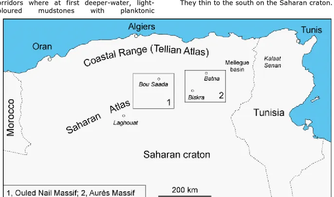
We present the first results of a France-Algeria Cooperation Programme (Tassili 05 MDU 652) aimed at better defining the sequence stratigraphy of the Cenomanian-Turonian (C/T) boundary event (CTBE) on the northern edge of the Saharan craton. These preliminary results are based on ten sections from the Ouled Nail and Aurès massifs in the western part of the Saharan Atlas (Fig. 1). Future work will be further to the East (Mellegue basin), in order to make a correlation with the Kalaat-Senan
reference section in northern Tunisia (ROBASZYNSKI et alii, 1993).
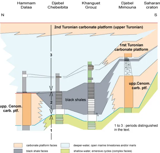
In the sections of the Ouled Nail massif (Fig. 2), we delineate three successive periods within the Late Cenomanian to Early Turonian interval. The first (lower part of the upper Cenomanian) and the last (the whole of the Turonian) correspond palaeogeographically to a ramp-type depositional system. The ramp is S-N oriented, from the Saharan craton to the deeper depositional environments of Algerian coastal range. During the intervening phase that lasted
only a short time (latest Cenomanian to earliest Turonian), the palaeogeography changes. Isolated carbonate platforms (rudists and/or oyster-bearing facies) develop on the Saharan craton and in some places of the former ramp to the north. These platforms are separated by corridors where at first deeper-water, light-coloured mudstones with planktonic
foraminifera and ammonites were deposited. The black shales of the Cenomanian-Turonian boundary event (CTBE) then fill these corridors. The shales pinch out on the platform edges. The S-N oriented ramp is reactivated in the early Turonian and marls are deposited everywhere. They thin to the south on the Saharan craton.
Figure 1: Situation of the studied areas in northern Algeria.
Figure 1 : Localisation des régions étudiées dans le Nord algérien.
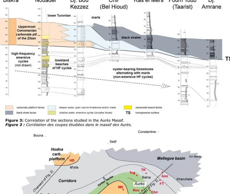
In the Aurès Massif, seven West-to-East sections have been correlated along a platform to basin transect (Fig. 3). The Biskra section could not be properly drawn, time lacking, but has been investigated in terms of facies. As in the Ouled Nails Massif, the same three periods can be detected. During the first period, the high-frequency emersive cycles of the Biskra section pass northward to non-emergent cycles consisting of oyster-bearing limestones (relative sea-level [RSL] lowstands) and marls (RSL highstands). In the intermediate Nouader section, the lowstand beach facies corresponding to the emergences in the Biskra section were found. The most outstanding feature of the transect is the lateral evolution of the rudist-bearing, carbonate platform facies of the Biskra section (Ziban platform) to a deeper-water mudstone, its thickness slowly decreasing to the North (Mellegue basin). Through this series of closely-spaced sections we have proved that about 35 m of rudistid facies may pass laterally to a basinal bed as thin as a few tens of centimetres. As in the Ouled Nail Massif, the black shales of the CTBE onlap the uppermost Cenomanian carbonate platform of the Ziban area (Biskra section).
The unconventional palaeogeography of the intermediate period that corresponds to the CTBE is shown on Figure 4. The replacement of the upper Cenomanian ramp profile by this
system of isolated platforms and corridors may be explained as a simple "keep-up" mechanism of carbonate platform growth during a period of slowly-rising sea level. In places where the shallow-water carbonate factory could keep up with a rising sea-level, the build-up of a platform began. In other areas, the depth was simply a bit too great, and continued to increase during the rise in relative sea-level. At first, these areas were the dump sites of periplatform oozes before the deposition of the CTB black shales began. During the last stage of the CTBE, the shallow-water carbonate factory ceased to function everywhere, perhaps due to an acceleration of the rise in sea level, or possibly because of other environmental factors. As in the Ouled Nail Massif, a black shale facies occupied the low-lying area (here the whole Mellegue basin) and filled it progressively, for the black shale facies clearly onlaps the Ziban platform to the South. When the topography was more uniform, lower Turonian open marine marls were deposited everywhere. This interpretation of the succession suggests that the CTBE black shales are present merely as the result of a confinement mechanism. A more complex interpretation cannot be excluded, taking into account the possible effect of other environmental factors. During the third period, a simple Turonian ramp is reactivated in the
direction of the Mellegue basin, with platform carbonates prograding and retreating several times.
Work in progress in other areas of the Saharan craton also suggests that gentle tectonic deformation during the CTBE may have enhanced the effect of the keep-up mechanism, and may account in part for the peculiar palaeogeography that for a time developed at the C/T boundary.
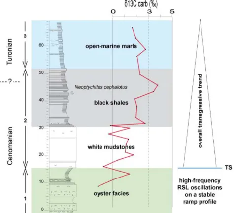
Stable isotope analyses have been made on four of all the sections studied, sited in both the Ouled Nail and Aurès massifs. The Chir (Bel Hioud) section is presented here (Fig. 5). Analyses show that in all sections the CTB anomaly is located in the black shale facies but may have started in the white mudstone bed below. In this bed, the somewhat erratic signature of the δ13C curve, its amplitude
depending on the sections, may be due to a weak dolomitization as seen in thin sections. So, it is tempting to correlate these results with those found in the Pueblo section of the Western Interior Basin of North America where the δ13C anomaly (PRATT, 1984; DESMARES et alii,
in press) starts in bed 63 of COBBAN & SCOTT
(1972). In addition, the white mudstone bed of
the Saharan Atlas at the base of interval 2 could be a remotely related equivalent of bed 63 at Pueblo where it too marks the beginning of the C/T transgressive trend.
Regarding the position of the C/T boundary, the occurrence of the ammonite Neoptychites cephalotus within the δ13C anomaly (Fig. 5) is
enigmatic, as this form is known to be of Turonian in age but in all reference sections of the world the C/T boundary is in the upper part of the δ13C anomaly.
[Français]
Dans le cadre du programme Tassili 05 MDU 652 (coopération franco-algérienne), destiné entre autres à décrire et définir, dans un cadre séquentiel précis, l'événement anoxique de la limite Cénomanien-Turonien sur la bordure nord de la plate-forme saharienne, sont présentés les résultats préliminaires obtenus à partir des coupes levées dans le massif des Ouled Nails et celui des Aurès. D'autres coupes seront effectuées dans le bassin du Mellègue afin de réaliser des comparaisons avec la coupe classique de Kalaat Senan en Tunisie (ROBASZYNSKI et alii, 1993).
Figure 2: Correlation of the sections studied in the Ouled Nail Massif.
Figure 3: Correlation of the sections studied in the Aurès Massif.
Figure 3 : Corrélation des coupes étudiées dans le massif des Aurès.
Figure 4: Palaeogeography of the eastern Saharan Atlas during period 2 (latest Cenomanian to earliest Turonian).
Figure 4 : Paléogéographie de la partie orientale de l'Atlas saharien au cours de la seconde période (Cénomanien
terminal à Turonien basal).
Dans les Ouled Nails (Fig. 2), il est possible de distinguer trois périodes dans l'ensemble allant du Cénomanien supérieur au Turonien. La première période (partie inférieure du Cénomanien supérieur) et la dernière (Turonien) correspondent à un dépôt sur une rampe régulière orientée globalement sud-nord depuis la plate-forme saharienne. La seconde,
intermédiaire, intéresse le Cénomanien terminal et l'extrême base du Turonien. Elle est caractérisée par la mise en en place d'une paléogéographie comportant des plates-formes isolées (faciès à rudistes et/ou à huîtres) séparées par des couloirs où sédimentent des boues carbonatées claires (mudstone) à foraminifères planctoniques et ammonites. Les
black shales de la limite Cénomanien-Turonien comblent ensuite les dépressions. Les marnes turoniennes de la rampe ultérieure, alors reconstituée, recouvrent l'ensemble.
Dans les Aurès (Fig. 3), une série de coupes en direction du bassin du Mellègue vers le N-E met en évidence une disposition analogue. En effet, elles montrent également, sur le profil de la rampe de la première période, que les exondations des cycles émersifs à haute fréquence (HF) de la plate-forme des Ziban se raccordent à des faciès de plage calca-rénitiques, à une quarantaine de kilomètres vers le N-E. Il est ainsi possible d'apprécier l'amplitude des déplacements de la ligne de
rivage sur ces cycles HF. Plus au N-E, les calcaires à huîtres de ces cycles HF, non émersifs, doivent être considérés comme les faciès distaux des plages de bas niveau. Les coupes sériées montrent également, en ce qui concerne la deuxième période, que le faciès à rudistes épais de la plate-forme des Ziban, passe latéralement à un banc de texture mudstone, comme dans les Ouled Nails mais son épaisseur diminue en passant de quinze mètres à moins d'un mètre vers la partie pro-fonde du bassin. Comme dans les Ouled Nails, les marnes gris sombre plus ou moins laminés (black shales) qui se déposent ensuite viennent en "onlap" sur la plate-forme des Ziban.
Figure 5: δ13C isotope curve in the Chir (Bel Hioud) section, and (to the right) sequence stratigraphy interpretation.
(TS, transgression surface; 1 to 3, periods distinguished in the text).
Figure 5 : Courbe isotopique du δ13C de la coupe de Chir (Bel Hioud) et interprétation séquentielle (à droite). (TS,
surface de transgression ; 1 à 2, périodes distinguées dans le texte).
La paléogéographie de la période intermédiaire est illustrée sur la Figure 4. Le remplacement d'un profil de rampe par le dispositif particulier des plates-formes isolées pendant la deuxième période peut être expliqué par un phénomène de croissance de type "keep-up" des faciès à rudistes au moment d'une élévation progressive du niveau marin relatif. Dans certains secteurs, les faciès carbonatés peu profonds "suivent" le niveau marin montant, dans d'autres non. La paléogéographie qui en résulte est ensuite ennoyée, suite à une accélération de la montée du niveau marin relatif. Des alternances de marnes et de calacaires s'installent alors dans tous les secteurs. Elles représentent un faciès confiné dans les creux de la topographie. Lorsque cette topographie diversifiée est
comblée, les marnes turoniennes de faciès marin ouvert se déposent sur l'ensemble de la région. Ces marnes se pincent progressivement en direction de la plate-forme saharienne ; la rampe turonienne s'installe à nouveau. La différenciation morphologique de la deuxième période n'est peut-être pas uniquement liée à la production carbonatée, mais, elle est aussi probablement liée à des déformations tectoniques légères, telles qu'elles sont suspectées ailleurs sur la plate-forme saharienne (travaux en cours).
Les analyses des isotopes sables, réalisées sur quatre des coupes levées, permettent de reconnaître l'anomalie géochimique classique en δ13C (coupe de Chir Bel Hioud, présentée sur la
principalement dans l'intervalle à black shales mais peut avoir débuté dans le banc de calcaire micritique plus ou moins épais sous-jacent. Dans ce banc on constate une signature isotopique plus ou moins erratique peut-être à mettre sur le compte d'une dolomitization légère vue en lames minces. Si l'anomalie débute bien dans ce banc, il serait tentant de le mettre en correspondance avec le banc 63 de COBBAN & SCOTT (1972) dans la coupe de
référence de Pueblo (bassin intérieur nord-américain) car l'anomalie en δ13C y débute
également (PRATT, 1984 ; DESMARES et alii, in
press). Ce banc 63 marque le tout début de la transgression de la limite C/T, tout comme dans l'Atlas saharien.
En l'absence, pour l'instant des données paléontologiques précises et en considérant que la limite biostratigraphique entre le Cénomanien et le Turonien se situe, dans les coupes de référence mondiales, vers le sommet de cette anomalie, la limite d'étage est provisoirement positionnée dans le sommet de l'intervalle à faciès de black shales dans les coupes de l'Atlas saharien. La présence à ce niveau de l'ammonite Neoptychites cephalotus, forme en principe turonienne non basale pose cependant un problème.
Bibliographic references /
Références bibliographiques
DESMARES D., GROSHENY D., BEAUDOIN B., GARDINS. & GAUTHIER-LAFAYE F. (in press).-
High-resolution stratigraphic record constrained by volcanic ashes layers at the Cenomanian-Turonian boundary in the Western Interior Basin, USA. - Cretaceous Research, Amster-dam.
COBBAN W.A. & SCOTT G.R. (1972).-Stratigraphy
and ammonite fauna of the Graneros Shale and Greehorn Limestone near Pueblo, Colorado. - U.S. Geological Survey Profes-sional Paper, Denver, n° 645, 108 p.
PRATT L.M. (1984).- Influence of
paleoenvironmental factors on preservation of organic matter in middle Cretaceous Greenhorn Formation, Pueblo, Colorado. - AAPG Bulletin, Tulsa, vol. 68, p. 1146-1159. ROBASZYNSKI F., CARON M., AMÉDRO F., DUPUIS C.,
HARDENBOL J., GONZALEZ-DONOSO J.M., LINARES
D. & GARTNER S. (1993).- Le Cénomanien de
la région de Kalaat Senan (Tunisie centrale) : litho-biostratigraphie et inter-prétation séquentielle. – Revue de Paléo-biologie, Genève, vol. 12, n° 2, p. 351-505.