HAL Id: hal-00299135
https://hal.archives-ouvertes.fr/hal-00299135
Submitted on 28 May 2004
HAL is a multi-disciplinary open access
archive for the deposit and dissemination of
sci-entific research documents, whether they are
pub-lished or not. The documents may come from
teaching and research institutions in France or
abroad, or from public or private research centers.
L’archive ouverte pluridisciplinaire HAL, est
destinée au dépôt et à la diffusion de documents
scientifiques de niveau recherche, publiés ou non,
émanant des établissements d’enseignement et de
recherche français ou étrangers, des laboratoires
publics ou privés.
Estimation of the seismic hazard parameters for various
sites in Greece using a probabilistic approach
I. D. Banitsiotou, T. M. Tsapanos, V. N. Margaris, P. M. Hatzidimitriou
To cite this version:
I. D. Banitsiotou, T. M. Tsapanos, V. N. Margaris, P. M. Hatzidimitriou. Estimation of the seismic
hazard parameters for various sites in Greece using a probabilistic approach. Natural Hazards and
Earth System Science, Copernicus Publications on behalf of the European Geosciences Union, 2004,
4 (3), pp.399-405. �hal-00299135�
Natural Hazards and Earth System Sciences (2004) 4: 399–405 SRef-ID: 1684-9981/nhess/2004-4-399
© European Geosciences Union 2004
Natural Hazards
and Earth
System Sciences
Estimation of the seismic hazard parameters for various sites in
Greece using a probabilistic approach
I. D. Banitsiotou1, T. M. Tsapanos1, V. N. Margaris2, and P. M. Hatzidimitriou1
1Aristotle University of Thessaloniki, School of Geology, Geophysical Laboratory, 54124 Thessaloniki, Greece 2ITSAK, Georgikis Sxolis 46, 55102 Finikas, Thessaloniki, Greece
Received: 25 November 2003 – Revised: 27 February 2004 – Accepted: 2 March 2004 – Published: 28 May 2004
Abstract. The probabilistic approach that was recently in-troduced by Kijko and Graham (1998, 1999) was applied for the estimation of seismic hazard for various sites in Greece in terms of peak ground acceleration (PGA) and peak ground velocity (PGV). These sites represent geographically cities of Greece among which are the capital of Greece and some oth-ers with high, intermediate and low seismicity. The approach allows the use of earthquake catalogues with incomplete re-ported historical and complete instrumental data, the consid-eration of different magnitude thresholds, and the incorpo-ration of magnitude uncertainties. One of the advantages of the method is that it does not require any determination of seismic zones. The estimated values of PGA for return pe-riods of 476 years were grouped in 4 categories, the same ones used in the seismic hazard map for the New Seismic Code of Greece. Comparison results were quite interesting and very encouraging concerning the reliability of this prob-abilistic approach.
1 Introduction
Most of the scientific work done in Greece concerning seis-mic studies, is the geographical distribution of the maxi-mum observed intensity (Galanopoulos and Delibasis, 1972) the maximum expected intensity (Shebalin et al., 1976; Pa-paioannou, 1984; Papazachos et al., 1985), peak ground ac-celeration or velocity (Algermissen et al., 1976; Drakopou-los and MakropouDrakopou-los, 1983; Papaioannou, 1984; Makropou-los and Burton, 1985) and the duration of the strong motion (Margaris et al., 1990; Papazachos et al., 1992). The sepa-ration of Greece and the surrounding area in several seismo-genic sources (Algermissen et al., 1976,; Papazachos, 1980; Hatzidimitriou, 1984; Papazachos et al., 1985; Makropoulos et al., 1988; Papazachos and Papazachou, 1989), the appli-cation of the method suggested by Cornell (1968) and the use of a computer program written by McGuire (1976) was
Correspondence to: T. M. Tsapanos
the basis of all the studies mentioned above and many more dealing with the same subject.
The seismic activity in the broad Aegean Area is extremely high and much has occurred within the historical period. One would, therefore, expect a considerable amount of seismo-logical information to be available. However, the incom-pleteness of the data, even for earthquakes of large magni-tude, makes the existing historical catalogues unsuitable for use in seismic hazard evaluation based on most methods pro-posed. Nevertheless, Kijko and Sellevoll (1987, 1989) have developed an approach utilizing the information on strong events contained in the macroseismic part of the catalogue as well as that contained in the complete catalogue.
There are two different approaches that one can use in or-der to make a seismic hazard analysis, the deterministic and the probabilistic. The first one is a more conservative analy-sis that accepts the worse scenario of seismic hazard. This is the reason why the deterministic analysis is used mainly in structures that require very high safety measures, as nuclear plants, dams etc. The second one is called probabilistic anal-ysis and accepts uncertainties in the earthquake magnitude, the location and time of generation.
The methodology that was used in this study is a prob-abilistic analysis and was proposed by Kijko and Graham (1998, 1999) in an attempt to try and solve the two main dif-ficulties that all probabilistic analysis have, the incomplete-ness of the seismic catalogues and the need of definition of the seismic zones. The new methodology combines the best features of the deductive (Cornell, 1968) and non- paramet-ric histoparamet-ric (Veneziano et al., 1984) procedures and in many cases is free from their main disadvantages.
2 Data used
The data used in the present study are from the data bank of the Geophysical Laboratory of the University of Thessaloniki (GLUT). Many efforts have been made during the past four decades to publish catalogues of earthquakes in Greece and the adjacent area (Galanopoulos, 1953, 1960, 1963; Karnik,
400 I. D. Banitsiotou et al.: Estimation of the seismic hazard parameters for various sites in Greece
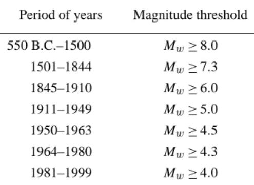
Table 1. Magnitude completeness catalogues (Papazachos et al., 2000).
Period of years Magnitude threshold 550 B.C.–1500 Mw≥8.0 1501–1844 Mw≥7.3 1845–1910 Mw≥6.0 1911–1949 Mw≥5.0 1950–1963 Mw≥4.5 1964–1980 Mw≥4.3 1981–1999 Mw≥4.0
1969, 1971; Comninakis and Papazachos, 1978, 1986, 1989; Makropoulos, 1978; Makropoulos et al., 1989; Papazachos and Papazachou, 1989, 1997; Papazachos et al., 1998). Us-ing these data Papazachos et al. (2000) (publication of Geo-physical Laboratory of Thessaloniki) formed a seismic cat-alogue (Fig. 1), which contains more than 60 000 earth-quakes for that area during 550 B.C. – 1999 with magnitudes 2.0 ≤ Mw≤8.3 and is divided in subcatalogues according to
the completeness of the magnitude in different time periods (Table 1). It is worth noticing that also the National Obser-vatory of Athens (NOA) publishes catalogues of events oc-curring in the broad Aegean area (www.gein.noa.gr).
Furthermore, the same authors (Papazachos et al., 2000) estimated the corresponding error in the magnitude of shal-low earthquakes and their epicenters is less than 0.25 and 20 km for the instrumental period 1911–1999, while for the historic period (550 B.C. – 1910) is 0.35 and 30 km, respec-tively.
3 Methodology and results
In order to study the attenuation relations of the strong ground motion at first were used relations from the other areas (Algermissen et al., 1976; Makropoulos, 1978; Makropoulos and Burton, 1985) but later studies used the attenuation relations that were derived for Greece and the adjacent area (Papaioannou, 1984, 1986; Papoulia and Stavrakakis, 1990; Theodulidis, 1991).
In an attempt to evaluate the studies done on that area many papers have been published (Drakopoulos and Makropoulos, 1983, 1985; Drakopoulos et al., 1986; Makropoulos et al., 1988, Stavrakakis, 1988; Drakopoulos and Stavrakakis, 1990; Papazachos et al., 1990).
Earlier works in the seismic hazard assessment for Greece and the adjacent area have been published by many re-searchers. Interesting results on simulation of strong ground motion were derived by Stavrakakis et al. (1986), Makropoulos et al. (1990), Margaris (1994), Theodulidis and Bard (1995).
Table 2. The b values used (Hatzidimitriou et al., 1994), the radius,
L, used for each city and the maximum observed magnitude mobsmax for each area (Banitsiotou, 2003).
Cities ϕ◦ λ◦ bvalue L Mmax (km) (obs) Alexandroupoli 40.85 25.87 0.7 53 7 Amfissa 38.52 22.38 1 53 7 Argostoli 38.17 20.48 1.1 75 7.3 Arta 39.15 20.98 1.1 47 6.9 Athens 37.98 23.72 0.9 26 6.4 Athos 40.25 24.23 0.8 75 7.3 Chalkida 38.47 23.58 0.9 53 7 Chania 35.52 24.02 1 42 6.8 Chios 38.38 26.13 0.9 42 6.8 Edessa 40.8 22.05 0.8 33 6.6 Florina 40.78 21.4 0.9 33 6.6 Igoumenitsa 39.5 20.27 1.1 47 6.9 Ioannina 39.67 20.85 1 26 6.4 Irakleio 35.35 25.12 1 66 7.2 Kalamata 37.03 22.1 1.1 47 6.9 Karditsa 39.37 21.92 1 42 6.8 Karpenisi 38.92 21.8 1 53 7 Kastoria 40.52 21.27 1 33 6.6 Katerini 40.27 22.5 0.9 33 6.6 Kavala 40.93 24.42 0.7 53 7 Kerkira 39.62 19.92 1.1 47 6.9 Kilkis 40.98 22.88 0.8 60 7.1 Korinthos 37.93 22.92 1 53 7 Kozani 40.3 21.78 0.9 33 6.6 Lamia 38.9 22.43 1 53 7 Larisa 39.63 22.42 0.9 53 7 Leukada 38.82 20.7 1.1 60 7.1 Livadia 38.43 22.87 1 53 7 Mesologi 38.37 21.42 1.1 42 6.8 Mitilini 39.1 26.57 0.8 66 7.2 Nafplio 37.57 22.8 1 47 6.9 Patra 38.27 21.73 1.1 42 6.8 Pirgos 37.67 21.43 1.1 47 6.9 Poligiros 40.37 23.43 0.8 33 6.6 Preveza 38.95 20.75 1.1 47 6.9 Rethimno 35.37 24.48 1 42 6.8 Rhodos 36.43 28.23 1 134 7.8 Samos 37.75 26.98 0.9 42 6.8 Serres 41.08 23.55 0.7 53 7 Sparti 37.07 22.42 1 42 6.8 Thessaloniki 40.63 22.93 0.8 33 6.6 Tripoli 37.5 22.37 1 47 6.9 Veroia 40.52 22.2 0.8 33 7 Volos 39.37 22.97 0.9 53 7.1 Zakinthos 37.78 20.88 1.1 59 6.6
In order to estimate the seismic hazard parameters for each one of the studied sites the main seismic catalogue of Greece was divided in subcatalogues. Afterwards, the seis-mic zones of Greece as proposed by Papaioannou and Pa-pazachos (2000) were used to get the maximum observed
I. D. Banitsiotou et al.: Estimation of the seismic hazard parameters for various sites in Greece 401
Fig. 1. Seismicity of Greece based on the seismic catalogue of Papazachos et al., 2000
magnitude, mobsmax, of each one of them. The values of the
mobsmaxwere used as Mwin the relation of Papazachos (1989):
log L = 0.51Mw−1.85 (1)
which provided the radius, L, for the circular area where the seismic data were taken for each site of study. The radius es-timated as well as the maximum observed magnitude, mobsmax, for every site are shown in Table 2.
It must be noted that the option of different radius areas for every site was considered only after using standard radius of 50, 75 and 100 km. The results that were estimated in those cases made it clear that it was compulsory to have different radius for different sites depending on the seismicity of the area, because in areas of low seismicity the seismic catalogue of radius 50 km was very small, giving results with big errors. On the other hand, for radius of 100 and 75 km in many cases the results were overestimated smoothing the seismicity of each site to a seismicity of larger area.
Besides these two parameters (mobsmaxand L) also parameter
bhas variable values at sites. The values of parameter b that were used in this study are the ones proposed by Hatzidim-itriou et al. (1994). Additionally, we took the earthquakes for the time-period 1994–1999 intending to find the new values of b parameter. The difference between the ones proposed by Hatzidimitriou et al. (1994) and the new ones was negligible.
So, all the data mentioned above were used in the first phase of the methodology in a computer program computed by Kijko, which gave the maximum possible magnitude
mposmax for each site. The values of m pos
max were used in the
second phase for the estimation of the seismic hazard param-eters (PGA, PGV).
The attenuation relations that were used for the estimation of the values of Peak Ground Acceleration (PGA) Eq. (2) and Peak Ground Velocity (PGV) Eq. (3) were the ones proposed by Margaris et al. (2001).
ln(P GA) = 3.52 + 0.70 · M
−1.14 · ln(R2+h20)1/2+0.12 · S ± 0.70 (2) ln(P GV ) = −2.08 + 1.13 · M
−1.11 · ln(R2+h20)1/2+0.29 · S ± 0.80 (3) where PGA is acceleration measured in units of gravity, (g), PGV is velocity measured in cm/s, M is the earthquake mag-nitude, R is the epicentral distance, h0 is the “effective”
depth of an event, which is, the depth where seismic energy is released and gets values h0=7 km for PGA and h0=6 km
for PGV and S is a factor of the soil conditions with values 0, 1 or 2 when it refers to hard rock, intermediate soil and soft soil, respectively. In the present study we used only interme-diate soil conditions, S = 1.
402 I. D. Banitsiotou et al.: Estimation of the seismic hazard parameters for various sites in Greece 8 0.13 0.30 0.22 0.08 PGA (g) I II III IV
Figure 2. Seismic hazard map in terms of Peak Ground Acceleration (PGA) for return period 476 years. (Banitsiotou, 2003) 5 15 25 35 PGV (cm/sec)
Figure 3. Seismic hazard map in terms of Peak Ground Velocity (PGV) for return period 476 years. (Banitsiotou, 2003)
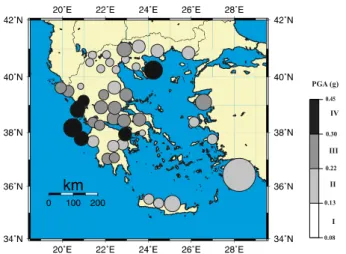
Fig. 2. Seismic hazard map in terms of Peak Ground Acceleration (PGA) for return period 476 years (Banitsiotou, 2003).
The results of the estimated PGA for a return period of 476 years are grouped in 4 categories and are shown in Fig. 2. The limits of values that were used in Fig. 2 are defined by the ones used in the map with the seismic hazard zones of Greece (Fig. 4) given as common report by the Geophysical Lab of A.U.TH and I.T.S.A.K. (2002) so that can be compar-ison between these two maps. In the Fig. 2 it is also depicted with a colored circle the area around each city that is possi-ble to have such ground acceleration. The circle in each city has a diameter equal to the estimated radius L, shown in Ta-ble (2). Values of PGA higher than 0.3 g were estimated for the Ionian Islands and specifically the island of Zakinthos, Cephalonia and Lefkada but also for the area around the city of Corinth and the peninsula of Atho. Values of PGA be-tween 0.22 and 0.3 g were estimated for the majority of the cities in central Greece while lower values than 0.22 g were estimated for the north part of Greece and also the most of Aegean islands that were in this study.
In Fig. 3 are shown the results of the Peak Ground Veloc-ity (PGV) for a return period of 476 years as well as the area that will possibly have an equal value of PGV. The map of Fig. 3 shows higher values in the Ionian Islands, values be-tween 15–25 cm/s in the central part of Greece and lowers than 15 cm/s in the north and south Greece.
The PGA and PGV values estimated for the regions of Crete and Dodecanese Islands, South Aegean Sea, are lower with respect to real ones since intermediate depth earth-quakes, taking place in these regions, were not considered given that in our analysis only shallow shocks have been taken into account. So, for the cities where earthquakes of intermediate depth occur the estimated values are not correct.
4 Comparison with similar studies and discussion The results of PGA that are shown in Fig. 2 were compared with the results given in the seismic hazard map of Greece shown in Fig. 4 which was given as a common report by the Geophysical Lab of of A.U.TH and I.T.S.A.K. (2002) . The
8 0.13 0.30 0.22 0.08 PGA (g) I II III IV
Figure 2. Seismic hazard map in terms of Peak Ground Acceleration (PGA) for return period 476 years. (Banitsiotou, 2003) 5 15 25 35 PGV (cm/sec)
Figure 3. Seismic hazard map in terms of Peak Ground Velocity (PGV) for return period 476 years. (Banitsiotou, 2003)
Fig. 3. Seismic hazard map in terms of Peak Ground Velocity (PGV) for return period 476 years (Banitsiotou, 2003).
summarized results of the comparison are shown in Table 3. As we can see in Table 3 the vast majority of the cities repre-senting a 64,4%, which were studied, are grouped in the same category in both Figs. 2 and 4. On the other hand, the cities with differences in the grouping are shown with gray color. It must be noted that the difference in category in some of the cities doesn’t mean necessarily big difference in the values. For example, for the city of Samos the estimated value in the present study was 0.2195 g and so it is in category II when the limit for category III where the report of the Geophysical Laboratory and I.T.S.A.K. (2002) situates it, is 0.22 g.
The values estimated in this study were also compared with the values of PGA and PGV estimated with the method-ology of McGuire (1976). The results of the comparison were very encouraging and the histograms of Figs. 5 and 6 show the frequency of the difference in the estimated values by these two methodologies for PGA and PGV, respectively.
5 Conclusions
The probabilistic methodology proposed by Kijko and Gra-ham (1999) was applied for the estimation of the Peak Ground Acceleration (PGA) and Peak Ground Velocity (PGV) for 45 sites in Greece. The magnitudes that were used in the earthquake catalogues are 4.0 ≤ M ≤ 8.3 and the attenuation relations employed were the ones proposed by Margaris et al. (2001).
The results were plotted in maps (see Figs. 2 and 3) and were compared with the ones given by the methodology of McGuire (1976) giving a very encouraging output. The map with the results for PGA (Fig. 2) was compared with the one given as a common report by the Geophysical Lab of A.U.TH and ITSAK (2002) (Fig. 4) and the results were summarized in Table 3 were most of the studied sites have good agree-ment with that report.
So, as a conclusion we can say that we have a tool for seismic hazard assessment, which in some cases is promising and comparable with corresponding classical methods.
I. D. Banitsiotou et al.: Estimation of the seismic hazard parameters for various sites in Greece 403
9
The PGA and PGV values estimated for the regions of Crete and Dodecanese
Islands, South Aegean Sea, are lower with respect to real ones since intermediate
depth earthquakes, taking place in these regions, were not considered given that in our
analysis only shallow shocks have been taken into account. So, for the cities where
earthquakes of intermediate depth occur the estimated values are not correct.
COMPARISON WITH SIMILAR STUDIES AND DISCUSSION
The results of PGA that are shown in Figure (2) were compared with the
results given in the seismic hazard map of Greece shown in Figure (4) which was
made for the New Seismic Code of Greece. The summarized results of the
comparison are shown in Table (3). As we can see in Table (3) the vast majority of
the cities representing a 64,4%, which were studied, are grouped in the same category
in both Figures (2) and (4). On the other hand, the cities with differences in the
grouping are shown with gray color. It must be noted that the difference in category in
some of the cities doesn’t mean necessarily big difference in the values. For example,
for the city of Samos the estimated value in the present study was 0.2195g and so it is
in category II when the limit for category III where the New Seismic Code of Greece
situates it, is 0.22g.
Figure 4. Map with the seismic hazard zones of Greece. (Geophysical Lab A.U.TH & I.T.S.A.K., 2002)
Fig. 4. Map with the seismic haz-ard zones of Greece (Geophysical Lab A.U.TH and I.T.S.A.K., 2002).
11
-0.005 0 0.005 0.01 0.015 0.02 0.025 PGAKijko-PGAMcGuire [g] 0 4 8 12 16 20 24 28 n 476 Years -0.5 0 0.5 1 1.5 2 PGVKijko-PGVMcGuire [cm/sec] 0 2 4 6 8 10 12 14 16 18 20 22 24 26 28 n 476 YearsFigure 5. Histograms of the difference in the
estimated values of PGA with the methodology of
Kijko and Graham (1999) and McGuire (1976)
for return period of 476 years. (Banitsiotou, 2003)
Figure 6. Histograms of the difference in the
estimated values of PGV with the methodology of
Kijko and Graham (1999) and McGuire (1976)
for return period of 476 years. (Banitsiotou, 2003)
CONCLUSIONS
The probabilistic methodology proposed by Kijko and Graham (1999) was
applied for the estimation of the Peak Ground Acceleration (PGA) and Peak Ground
Velocity (PGV) for 45 sites in Greece. The magnitudes that were used in the
earthquake catalogues are 4.0
≤
M
≤
8.3 and the attenuation relations employed were
the ones proposed by Margaris et al. (2001).
The results were plotted in maps (see Figure 2,3) and were compared with the
ones given by the methodology of McGuire (1986) giving a very encouraging output.
The map with the results for PGA (Figure 2) was compared with the one given for the
New Seismic Code of Greece (Geophys. Lab. A.U.TH & ITSAK, 2002) (Figure 4)
and the results were summarized in Table (3) were most of the studied sites have good
agreement with the New Seismic Code of Greece.
So, as a conclusion we can say that we have a tool for seismic hazard
assessment, which in some cases is promising and comparable with corresponding
classical methods.
Fig. 5. Histograms of the difference in the estimated values of PGA with the methodology of Kijko and Graham (1999) and McGuire (1976) for return period of 476 years (Banitsiotou, 2003).
11
-0.005 0 0.005 0.01 0.015 0.02 0.025 PGAKijko-PGAMcGuire [g] 0 4 8 12 16 20 24 28 n 476 Years -0.5 0 0.5 1 1.5 2 PGVKijko-PGVMcGuire [cm/sec] 0 2 4 6 8 10 12 14 16 18 20 22 24 26 28 n 476 YearsFigure 5. Histograms of the difference in the
estimated values of PGA with the methodology of
Kijko and Graham (1999) and McGuire (1976)
for return period of 476 years. (Banitsiotou, 2003)
Figure 6. Histograms of the difference in the
estimated values of PGV with the methodology of
Kijko and Graham (1999) and McGuire (1976)
for return period of 476 years. (Banitsiotou, 2003)
CONCLUSIONS
The probabilistic methodology proposed by Kijko and Graham (1999) was
applied for the estimation of the Peak Ground Acceleration (PGA) and Peak Ground
Velocity (PGV) for 45 sites in Greece. The magnitudes that were used in the
earthquake catalogues are 4.0
≤
M
≤
8.3 and the attenuation relations employed were
the ones proposed by Margaris et al. (2001).
The results were plotted in maps (see Figure 2,3) and were compared with the
ones given by the methodology of McGuire (1986) giving a very encouraging output.
The map with the results for PGA (Figure 2) was compared with the one given for the
New Seismic Code of Greece (Geophys. Lab. A.U.TH & ITSAK, 2002) (Figure 4)
and the results were summarized in Table (3) were most of the studied sites have good
agreement with the New Seismic Code of Greece.
So, as a conclusion we can say that we have a tool for seismic hazard
assessment, which in some cases is promising and comparable with corresponding
classical methods.
Fig. 6. Histograms of the difference in the estimated values of PGV with the methodology of Kijko and Graham (1999) and McGuire (1976) for return period of 476 years (Banitsiotou, 2003).
404 I. D. Banitsiotou et al.: Estimation of the seismic hazard parameters for various sites in Greece
Table 3. Summarized results of PGA with return period 476 years of the present study and the one done for the New Seismic Code of Greece (Banitsiotou, 2003).
City PGA (g) Present Study N.S.C.G. Alexandroupoli 0.15 II II Athina 0.14 II III Athos 0.31 IV III Amfissa 0.26 III III Argostoli 0.41 IV IV
Arta 0.33 IV III
Veroia 0.17 II II Volos 0.28 III III Edessa 0.17 II II Zakinthos 0.38 IV IV Igoumenitsa 0.26 III III Irakleio 0.16 II III Thessaloniki 0.17 II III Ioannina 0.20 II III Kavala 0.16 II II Kalamata 0.22 III III Karditsa 0.27 III III Karpenisi 0.27 III III Kastoria 0.17 II II Katerini 0.16 II II Kerkira 0.23 III III Kilkis 0.29 III III Kozani 0.17 II II Korinthos 0.31 IV IV Lamia 0.24 III III Larisa 0.16 II III Livadia 0.30 III III Lefkada 0.34 IV IV Mesologi 0.27 III III Mitilini 0.23 III III Nafplio 0.21 II III Patra 0.26 III III Poligiros 0.17 II III Preveza 0.33 IV III Pirgos 0.21 II III Rethimno 0.14 II III Rhodos 0.20 II III Samos 0.22 II III Serres 0.20 II II Sparti 0.25 III III Tripoli 0.22 II II Florina 0.16 II II Chalkida 0.29 III III Chania 0.15 II III Chios 0.21 II III
Acknowledgements. We would like to acknowledge the logistical support by GMT (Generic Mapping Tools) for the computation of the maps in this study.
Edited by: M. Contadakis Reviewed by: two referees
References
Banitsiotou, I. D., Tsapanos, T. M., Hatzidimitriou, P. M., and Mar-garis, V. N.: Estimation of the seismicity and seismic hazard pa-rameters in the seismogenetic zones of Greece and the adjacent area using the modified Bayesian methodology, Master Disserta-tion, Aristotle University of Thessaloniki, 93, 2003.
Comninakis, P. E. and Papazachos, B. C.: A catalogue of earth-quakes in the Mediterranean and the surrounding area for the pe-riod 1901–1975, Publ. Geophys. Lab. Univ. Thessaloniki, 5, 96, 1978.
Comninakis, P. E. and Papazachos, B. C.: A catalogue of earth-quakes in Greece and surrounding area for the period 1901–1985, Publ. Geophys. Lab. Univ. Thessaloniki, 1, 167, 1986.
Comninakis, P. E. and Papazachos, B. C.: Aftershock and fore-shock sequences in Greece and surrounding area during the pe-riod 1911–1985, Publ. Geophys. Lab. Thessaloniki, 5, 156, 1989. Cornell, C. A.: Engineering Seismic Risk Analysis, Bull. Seism.
Soc. Am. 58, 1503–1606, 1968.
Galanopoulos, A. G.: On the intermediate earthquakes in Greece, Bull. Seism. Soc. Am., 43, 159–178,1953.
Galanopoulos, A. G.: A catalogue of shocks with I o≥V I or M≥5 for the years 1801–1958, Athens, 119, 1960.
Galanopoulos, A. G.: On mapping of seismic activity in Greece, Annali di Geof., 16, 37–100, 1963.
Geophysical Laboratory of Aristotle University of Thessaloniki and Institute of Engineering Seismology and Earthquake Engineering (ITSAK): Collection and Procession of Seismological data and computation of seismic hazard map of Greece according to the current Greek Seismic Code and Eurocode 8, 38, 2002. Hamdache, M. and Retief, S. J. P.: Site-Specific Seismic Hazard
Es-timation in the Main Seismogenic Zones of North Algeria, Pure and Applied Geophysics 158, 1677–1690, 2001.
Hatzidimitriou, P. M., Papazachos, B. C., and Karakaisis, G. F.: Quantitative Seismicity of the Aegean and Surrounding Area, XXIV General Assembly of E.S.C., Athens, 19–24 Septem-ber 1994, 1, 155–164, 1994.
K`arn`ık, V.: Seismicity of the European Area. Part I, D. Reidel Pub-lishing Company, Dordrecht-Holland, 364, 1969.
K`arn`ık, V.: Seismicity of the European Area. Part II, D. Reidel Pub-lishing Company, Dordrecht-Holland, 218, 1971.
Kijko, A. and Graham, G.: Parametric-Historic Procedure for Prob-abilistic Seismic Hazard Analysis, Part I: Estimation of Maxi-mum Regional Magnitude mmax, Pure and Appl. Geophys., 152, 413–442, 1998.
Kijko, A. and Graham, G.: “Parametric-Historic” Procedure for Probabilistic Seismic Hazard Analysis, Part II: Assessment of Seismic Hazard at Specified Site, Pure and Appl. Geophys., 154, 1–22, 1999.
Makropoulos, K. C.: The statistics of large earthquake magnitude and an evaluation of Greek seismicity, Ph.D. thesis, Univ. of Ed-inburgh, 193, 1978.
Makropoulos, K. and Burton, W. P.: Seismic Hazard in Greece, II. Ground Acceleration, Tectonophysics, 117, 259–294, 1985. Makropoulos, K., Stavrakakis, G., Latoussakis, J., and
Drakopou-los, J.: Seismic Zoning Studies in the Area of Greece Based on the Most Perceptible Earthquake Magnitude, Geofizika, 5, 37– 48, 1989.
Mantyniemi, P., Tsapanos, T. M., and Kijko, A.: An Estimate of Probabilistic Seismic Hazard for Five Cities in Greece by Us-ing the Parametric-historic Procedure, EngineerUs-ing Geology, 72, 217–231, 2004.
I. D. Banitsiotou et al.: Estimation of the seismic hazard parameters for various sites in Greece 405
Margaris, V., Papazachos, C. B., Papaioannou, Ch. A., Theodu-lidis, N., Kalogeras, I., and Skarlatoudis, A.: A Ground Motion Attenuation Relations for Shallow Earthquakes in Greece, 12th Europ. Conf. on Earthquake Engineering, in press 2004. McGuire, R. K.: FORTRAN Computer Program for Seismic Risk
Analysis, U.S. Geol. Surv., Open file rep., 76–67, 69, 1976. Papadopoulos, G. and Kijko, A., Maximum Likelihood
Estima-tion of Earthquake Hazard Parameters in the Aegean Area from Mixed Data, Tectonophysics, 185, 277–194, 1991.
Papaioannou, Ch. A. and Papazachos, B. C.: Time-Independent and Time-Dependent Seismic Hazard in Greece Based on Seismo-genic Sources, Bull. Seism. Soc. Am., 90, 1, 22–33, 2000. Papazachos, B. C.: Measures of the Earthquake size in the area
of Greece. 1st Scientific Congress of the Hellinic Geophysical Union, Athens, April 1989, 437–447, 1989.
Papazachos, B. C. and Papazachou, C. B.: The earthquakes of Greece (in Greek), Ziti Publ., Thessaloniki, 356, 1989.
Papazachos, B. C. and Papazachou, C. B.: The earthquakes of Greece, Ziti Publ., Thessaloniki, 304, 1997.
Papazachos, B. C., Karakostas, V. G., Scordilis, E. M., Papaza-chos, C. B., Papaioannou, Ch. A., and Karakaisis, G. F.: A cat-alog for the Aegean and Surrounding Area for the Time Period 550 B.C.–1997, Thessaloniki, 1998.
Papazachos, B. C., Comninakis, P. E., Karakaisis, G. F., Karakostas, B. G., Papaioannou, Ch. A., Papazachos, C. B., and Scordilis, E. M.: A catalogue of earthquakes in Greece and sur-rounding area for the period 550 B.C.–1999, Publ. Geophys. La-bor., University of Thessaloniki, 2000.
Tsapanos, T. M.: A Seismic Hazard Scenario for the Main Cities of Crete Island, Greece, Geophys. J. Int., 153, 403–408, 2003. Veneziano, D., Cornell, C. A., and O’Hara, T.: Historic Method for
Seismic Hazard Analysis, Elect. Power Res. Inst., Report, NP-3438, Palo Alto, 1984.