voice assisted automobile
navigation
by
James Raymond Davis
B.S.A.D., Massachusetts Institute of Technology (1977)
Submitted to the Media Arts and Sciences Section
in partial fulfillment of the requirements for the degree of
Doctor of Philosophy
at the
MASSACHUSETTS INSTITUTE OF TECHNOLOGY
September 1989
@Massachusetts
Institute of Technology 1989
All Rights Reserved
Signature of Author. ... ... /...
Media Arts and Sciences Section
August 4, 1989
Certified by ...
...
Nicholas P. Negroponte
Profe
7gor of Media Technology
('~
/
/ /
T
.uDerviisorAccepted by...
Stephen A. Benton
Chairman, Departmental Committee on Graduate Students
MASSACHUSETTS INSTITUTE
OF TECHNOl nAy
FEB 2 7 1990
Back Seat Driver:.
Back Seat Driver: voice assisted automobile navigation
by
James Raymond Davis
Submitted to the Media Arts and Sciences Section on August 4, 1989, in partial fulfillment of the
requirements for the degree of Doctor of Philosophy
Abstract
The Back Seat Driver is a computer navigation assistant for drivers in a city. It differs from earlier navigation programs by using speech, rather than graphics, to give instructions. The advantages of speech are that the driver's eyes are left free for driving and that the spoken directions contain information not easily portrayed in pictures. The program talks about the features of the road in the same way the driver sees them, giving the impression that the program is actually is in the car.
Driving instructions are modeled after those given by people. The two issues for spoken directions are what to say (content) and when to say it (timing). The content of the instructions tells the driver what to do and where to do it. The program has a large taxonomy of intersection types, and chooses verbs to indicate the kind of intersection and the way of moving through it. The instructions refer to landmarks and timing to tell the driver when to act.
Timing is critical because speech is transient. Drivers hear instructions just in time to take the required action, and thus need not remember the instruction or ffort looking for the place to act. The program also gives instructions in auvance, if time allows, and the driver may request additional instructions at any time. If the driver makes a mistake the program describes the mistake. without casting blame, then finds a new route from the current location.
Street map data bases for navigation programs must distinguish between phys-ical connectivity (how pieces of pavement connect) and legal connectivity (whether one can legally drive onto a physically connected piece of pavement). Legal con-nectivity is essential for route finding, and physical concon-nectivity for describing the route. The database must also contain all landmark information, since the program has no "eyes".
The Back Seat Driver is an actual working prototype. It has successfully guided drivers unfamiliar with Cambridge to their destinations. Although much work remains, it is easy to foresee a practical implementation in the future.
Thesis Supervisor: Nicholas P. Negroponte Title: Professor of Media Technology
Acknowledgments
I owe gratitude to many people for help with this work. In particular I would like to thank: Phil Rittmueller and NEC Home Electronics (USA) Inc., who sponsored it; Symbolics Inc., Digital Equipment Corporation, the Nippon Telephone and Telegraph company, and DARPA, which sponsored my earlier graduate studies; Brewster Kahle, who provided the original inspiration for my work on comput-erized direction giving in the summer of 1985; Thinking Machine Corporation, where the work was conducted; and Tom Trobaugh, who began that study with me. I thank those who provided me with helpful information: James A. O'Connell, Jr. and Peter Naghavi of the Somerville Department of Traffic and Parking, Jane Kent of the Cambridge Department of Traffic, and George Hawat of the Boston Transportation Department, for providing traffic light data bases; Doris Walter of the Massachusetts District Commission for maps of rotaries; Doug Milliken for explanations of car dynamics; Don Cooke of Geographic Data Technology and Joel Sobel of the Census Bureau for information on the DIME and TIGER map for-mats; David Pietraszewski of the United States Coast Guard and Michael Fisher of Trimble Navigation for information about GPS. The photo on page 60 was taken by Kyle G. Peltonen, and is reprinted by permission of The Tech, the Mr. Boffo cartoon is reprinted courtesy of the Tribune Media Services. I thank also Weng-yew Ko for building hardware interfaces; Elaine McNair at NEC for removing many ob-stacles; Michael Sullivan of Spectrum Communication for solving communications problems; Greg Parro of Cellular Phone Services for excellent service with the
tele-phones; Hidehiro Matsumoto of NEC for translations to and from the Japanese; Janette Noss and Elaine McCarthy, who keep the Architecture Machine Group running; Anna Korteweg, Walter Bender, Gary Drescher, and Carol Strohecker for careful editing, and Shawn T. Williams and Greg Grove, who helped by partici-pating in UROP work. I wish to thank all those who taught me of computational linguistics, especially Barbara Grosz, Julia Hirschberg, and Janet Pierrehumbert. They of course bear no responsibility for my failure to fully grasp the material they attempted to teach me. My committee members were Steven Benton, Mike Lesk, Nicholas Negroponte, and Chris Schmandt. None of these people, of course, are responsible in any way for the ways I have misunderstood their ideas or abused their work, or for my failure to heed their advice. Finally I must specially mention Nicholas Negroponte, who created the Media Lab where this work was possible, and Chris Schmandt, the director of the Speech Research Group, who has been directly involved in everything I have done here at the Media Lab. A full list of his contributions to my studies would require many pages.
Those I have forgotten or otherwise neglected, I can only ask to deepen my debt by forgiving my shoddy memory and inexpressive words.
Contents
1 Overview
I
Natural Directions
2 Human Direction Giving
2.1 Instructions ... 2.1.1 Verbs . . . .
2.1.2 Direction . . .
2.2 Distance and Time 2.2.1 Landmarks 2.2.2 Advance Notice 2.3 Advice . . . .
2.4 Style and Packaging 2.5 Silence . . . . 2.6 Example Instructions .
21
22 . . . . 2 4 . . . . 2 5 . . . . 2 8 . . . . 2 9 . . . . 3 1 . . . 3 2 . . . 3 3 . . . 3 3 . . . . 3 4 . . . . 3 6II Implementation of the Back Seat Driver
3 Cartography3.1 DIME format ... ...
3.2 The limits of DIME . . . .
3.2.1 The model of connection is deficient . . . .
3.2.2 Position resolution is inadequate . . . .
3.2.3 The forthcoming TIGER format is better, but not
3.3 A better m ap . . . .
3.3.1 Legal connectivity . . . .
3.4 Additional segment attributes . . . . 3.4.1 Quality combines size and speed of a segment . .
3.5
3.6
3.4.2 Expanded street classifications . 3.4.3 Divided Roads . . . . 3.4.4 Landmarks help directions . . .
3.4.5 Lane information . . . . 3.4.6 DIME files need correction . . .
Other maps . . . . Improvements are still needed . . . . . 3.6.1 Summary . . . .
41
42 . . . 42 . . . . 44 . . . 44 . . . . 45 enough . 46 . . . 48 . . . . 48 . . . . 48 . . . . 49 . . . 49 . . . . 52 . . . . 52 . . . . 54 . . . . 54 . . . . 55 . . . . 58 . . . . 61 4 Descriptions 4.1 Classifying movement. . . . . 62 63. . . . 6 5 4.3 4.4 4.5 4.6 4.7 4.8 What to do . . . . When to do it . . . . . 4.4.1 Timing ... 4.4.2 Cues . . . . 4.4.3 Landmarks . . 4.4.4 Street names as Advice . . . . Discourse . . . . Mistakes ... . . . . Reassuring . . . .
5 User and System Goals
5.1 Resource allocation . . .
5.2 Architecture . . . ..
5.3 Kinds of Goals...
5.3.1 Finding Services .
5.3.2 Other user goals .
5.3.3 System goals . . . . . . 69 . . . . . . 71 . . . . . 71 . . . . 72 . . . . 74 . . . . 75 landmarks. . . . . . . . . . 77 ... 77 . . . . 78 . . . . 80 82 . . . . 83 . . . . . . . . . . . . . . . . . . . . . . . . 84 . . . . 8 7 . . . . 88 . . . . 89 . I . . . . 8 9 6 Comparing Routes
6.1 Comparing routes requires a metric . . . .
6.2 Estimating the time required to find a route . . . . 4.2 Definitions of actions
III Conclusions
7 Related Work7.1 Early Work
98
. . . . 9 8
7.2 Elliot and Lesk ...
7.3 Direction Assistance ...
7.3.1 Entering addresses . . .
7.3.2 Generating text . . . . .
7.3.3 Route Finding differences
7.4 Text-Based Directions . . . .. 7.4.1 Counter Top Directions. 7.4.2 M a . . . . 7.5 Automotive Navigation Systems
7.6 Classifying navigation systems
8 Future Developments
8.1 Integration with the car . . . .
8.2 Knowing the driver . . . .
8.2.1 Improving the directions
8.2.2 Learning about the driver
8.3 Confidence... ...
8.4 Speech interface issues . . . . . 8.4.1 Speech output . . . . . . . . 99 . . . 10 1 . . . 10 2 . . . 10 3 . . . 104 . . . 10 5 . . . 10 5 . . . . . . . 10 5 . . . . 10 6 . . . 10 7 110 . . . 110 . . . 111 . . . 1 12 . . . 1 12 . . . 1 14 . . . 1 16 . . . 1 16
97
8.4.2 Speech input . . Understanding the route Other directions. . . . . Changes to the map . . Integration with the city Policy . . . . 8.9.1 Liability... 8.9.2 Privacy . . . . . . . . 117 . . . 117 . . . 120 . . . 12 0 . . . 12 1 . . . 122 . . . 122 . . . 12 3 125 A Location Systems A.1 Accuracy requirements of the Back Seat Driver Classifying location systems . Position finding . . . . A.3.1 LORAN-C . . . . A.3.2 Polled pulse time ranging A.3.3 GPS . . . . A.3.4 TRANSIT ... A.3.5 Other satellite systems . . A.3.6 Beacons . . . . The cellular phone system A.3.7 A.3.8 127 . . . 127 . . . 128 . . . 129 . . . 129 . . . 131 . . . 132 . . . 133 . . . 134 . . . 135
night serve as a location system . 136 V ision . . . .1 8.5 8.6 8.7 8.8 8.9 9 Summary A.2 A.3 . . . .137
A.4 Position keeping . . . 137 A.4.1 Dead reckoning systems need correction . . . 138 A.5 Hybrid systems . . . 140
B Route Finding 142
B.1 Breadth-first search considers all possible partial solutions in parallel 143
B.2 Best-first search saves effort . . . 145 B.3 A* search avoids falsely promising paths . . . 146 B.3.1 A suboptimal, but faster algorithm, is desirable . . . 147
C Communication with the car 149
C.0.2 Cellular phones are hostile for data transmission . . . 150
List of Figures
2-1 Fulkerson turns into Binney . . . 2 7 2-2 Map for sample route . . . .
3-1 Position roundoff makes headings uncertain . . . .... 45
3-2 Short segments have less angular resolution . . . 46
3-3 Coordinate rounding makes streets seem to wobble . . . 47
3-4 The "super" streets of Boston . . . 50
3-5 A rotary . . . 51
3-6 Access ramps at an interchange . . . .. . . 52
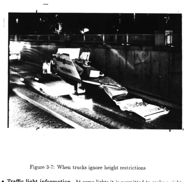
3-7 When trucks ignore height restrictions . . . 60
4-1 T, fork, and exit all have same topology . . . 64
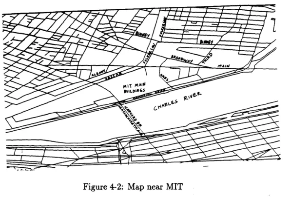
4-2 Map near MIT . . . 70
5-1 Resource allocation . . . 85
6-1 Four routes from 12 Albany Street to 4 Glenville Terrace 7-1 A U turn . . . . . . . . 93
7-2 example of driving instructions provided by Hertz
A-1 Fraction of segments shorter than X in meters .
A-2 Geometric Dilution of Precision . . . .
A-3 Dead reckoning errors increase with distance . .
A-4 Map matching corrects dead reckoning errors . . A-5 Dead Reckoning corrects for loss of GPS signal .
B-1 Breadth-first search example . . . .
C-1 Communications block diagram . . . .
C-2 Histogram of durations of odometer sequence . .
C-3
C-4
. . . 12 8 . . . 130 . . . 139 . . . 140 . . . 141 . . . 145 . . . 150. . . 15 1
Probability of cellular call termination increases with time Histogram of inter-arrival times of packets . . . . . . .. ... 152. . . 153
List of Tables
2.1 Verbs in descending order of frequency . . . 25
2.2 Notation system for transcriptions . . . 36
B.1 Breadth-first search considers many potential routes . . . 146
B.2 A* search touches fewer segments, and is therefore faster . . . 147
B.3 Comparative search times and route lengths for 30 routes with dif-ferent values of distance weight factor . . . 148
frontispiece
MISTE= BOFFO by Joe Martin
Chapter 1
Overview
This thesis is about the design and construction of a machine that does some-thing difficult and useful in a new way. The machine's purpose is help people find their way by car from one place to another within a city, a task which is clearly useful and also worth improvement. A study done for the United States Federal Highway Administration estimated that 45 billion dollars are wasted each year in the U.S. because of ineffective routing, from causes including being lost, stuck in traffic, or choosing bad routes[1]. The machine discussed here is called the Back
Seat Driver1. The Back Seat Driver is a computer program which uses synthetic
speech to give instructions to the driver of a car as needed while driving. The Back Seat Driver differs from previous navigation assistance programs by using speech to give directions2, instead of drawing a map or displaying symbols.
My two concerns are to determine the best form and content for spoken
instruc-tions, and to determine what information a program requires in its map to find routes and provide excellent instructions. My approach towards both questions is
'The usual sense of this term is an unwanted critic of one's driving skills. This is not what I intend.
2
Although there are reports of earlier navigation systems using speech, none are described in the literature.
empirical. The initial design of the program was based on a short study of natural direction giving. This initial design was the "initial conditions" for an iterative process of design, testing with drivers, and revision. When the design was wrong, drivers complained, or just got lost, and I changed the design until they stopped complaining. This thesis describes the design that emerged from this process.
The thesis is divided into three parts. The first part, Natural Directions, describes the strategies and styles than people use when giving directions. The second part, Implementation, describes the program. Chapter 3 describes the map database. The next chapter tells how the Back Seat Driver decides what
to say and when to say it. This is the key to the entire thesis. Chapter 5 tells about the other things the program does (such as read mail), and how it decides which task to work on at a given time. Chapter 6 tells how the Back Seat Driver evaluates routes when searching for the best one. The final part, Conclusion, describes related work, then tells how the Back Seat Driver might be improved
and suggests directions for future research.
Three appendices provide background material and certain details of the imple-mentation. The first two set out the technologies and concepts used in this program and in vehicle navigation in general. Depending on what you know already, you may have to read one or both of these section before reading earlier sections. The third appendix describes data communications using cellular telephones.
Why speech?
The first issue in design of a vehicle navigation system is the choice of modality
for giving instructions. Two channels seem possible: vision and hearing3. Given
the technical ability to display a map on the dashboard, or to display directional 3We could also consider the haptic channel. This is how people tell horses which way to go.
arrows on the windshield, or the ability to synthesize speech, which should we choose?
Previous in-car navigation systems have used the visual channel to give navi-gation information. The Back Seat Driver uses speech because there are reasons not to use vision, and some advantages to speech.
Much work has been devoted to developing systems that display the vehicle's position on a map in the car (or at a dispatching facility). When combined with the ability to display a route (or at least the relative or absolute position of the destination), such displays can be used for navigation. One argument against such displays is that they require that the driver look at them while driving, and this makes driving less safe. Although drivers can spare some visual attention while driving along straight roads[88], it is not as clear that they can afford to look at the map while turning, yet it is just while turning that drivers are most in need of navigation information. Visual displays are most easily used when they are least needed.
A second argument against the use of maps is that many people have difficulty finding and following routes on paper maps[81]. That is, they are not "map liter-ate". Information presented on maps will simply be unintelligible to such people. Paper maps do not really qualify as navigation assistance, since they do not show the driver's current position, though they may show the route.
An experiment comparing navigation aids was conducted by Streeter [82], who compared the performance of drivers under three different conditions. One set of drivers received customized paper maps with the route to be driven highlighted in red. A second set of drivers heard spoken instructions from a tape player that permitted them to play the next or previous instruction. Drivers using the maps took longer to arrive than those who had verbal instructions. They also made more errors and drove further. This can be explained by the extra effort required to consult the paper map. The third set of drivers got both navigational aids.
Surprisingly, drivers with both sources of information did worse than those using only voice, though better than those with a map only.
Neither navigation aid in the Streeter experiment included information about the current position. Both required the driver to determine when to carry out the instruction and to decide whether the instruction was correctly executed. That is, the driver could play an instruction as often as she liked, but had to decide for herself when to advance to the next instruction. The experiment did not compare voice to either an electronic map (indicating current position as well as route) or directional symbols (indicating which way to go). For this reason, the experiment does not directly answer the question about choice of modality. It is, at best, suggestive.
One advantage of speech is that the driver's eyes are left free for driving. In addition, speech uses words, and can therefore refer to past and future actions and objects not yet seen. This is hard to do with symbolic displays or maps.
On the other hand, speech has some problems as well. Speech is transient. The driver must remember what the program said, and the program must be prepared to repeat itself on demand. A second consequence of the ephemeral nature of speech is that the driver has no evidence of the program's operation except when it speaks. In a period of long silence, the driver may fear that the program has failed4. The program must do extra work to keep the driver confident in its continued operation. This turns out to be beneficial. Some of the remarks the program makes have little to do with route following per se, but rather are descriptions of the immediate vicinity of the road. When these are uttered at the right time, the driver gets a very strong sense that the program is seeing the world in the same way she does, and this is very reassuring.
The arguments here against maps and for speech convinced me that the Back
4Programs - especially prototypes - are not as reliable as, say, telephones. No one worries
Seat Driver should speak its directions. The next section tells how people speak their directions.
Part I
Chapter 2
Human Direction Giving
My investigations began by studying how people give directions when they are
passengers in the car. The intent was to discover common patterns in the directions that could be duplicated by the Back Seat Driver. The number of subjects (six) was far too small to justify any general conclusions about direction giving, but that was not the intention. I studied human direction giving to get a starting point for the design of the Back Seat Driver, not an ending point. I built the Back Seat Driver through an iterative process of design, test, and modification which converged to the system described in this thesis. All I needed was a good first approximation, and a sense of the kinds of variation in direction giving style, and for this I think six subjects was sufficient.
Procedure
My six subjects told me how to drive to destinations of their choosing while
go to their destination, so they had an incentive to give good directions. (They did not all provide the best routes, but route finding was not a subject of this investigation.) Most, but not all, of their utterances were spontaneous. In some cases I asked questions - "What now?" or "How long will I be on this road?". Our conversations were recorded on a cassette recorder in the car. All talk relevant to the route was transcribed, but most personal conversation was not transcribed. The transcriptions- included approximate position of the car, as determined from memory. A sample transcription appears at the end of this chapter.
There are limits to the usefulness of this method. By its very nature, there is no way to control for the route or the destination. No two trips led to the same destination, though several had common beginnings. I assume that there is nothing special about the routes, so I can generalize. The usefulness of this data depends upon the assumption that the subjects were competent to give instructions and that the instructions were in the same form that subjects would have wanted to hear, had they been the driver. There is certainly some doubt about this point. We could do better than to emulate subjects who hesitated, gave misleading directions, or simply pointed'. Another limitation is that the transcriptions show position only coarsely, and velocity not at all, so they can not be used to answer questions of timing.
Overview
My understanding of driving instructions comes from treating driving as
deci-sion making. I think of the driver as constantly aiming the car at a moving target, a patch of pavement some few yards ahead. The driver is making a new decision several times a second. Some of these decisions involve choosing the next street to go along. When following instructions, at each point of decision one of two
ditions must apply: either the instructions must say explicitly what to do, or the driver and instruction-giver must mutually believe that the thing to do is obvious and does not need to be said. This is by far the more common condition. It is only at an intersection that there is any meaningful choice, and even there there is a presumption that drivers will continue forward. Giving instructions should be the exception, not the rule. The traditional "back seat driver" - the annoying critic, not the program I built - bothers the driver by giving frequent warnings about conditions the driver is perfectly aware of, acting as if the driver had no common sense.
Navigators must give the driver the information she needs at the time she needs it. At the most basic level, this information consists of instructions. Instructions concern what to do and when (or where) to do it. People also provide advice which concerns unseen conditions ahead that the instruction giver can anticipate based on experience. The driver can ignore advice, but it may then be harder to follow the instructions. There is also orientation information, describing the surroundings, and placing the route in a larger image of the city. Instructions are essential; advice helpful; and orientation optional. Although I think orientation is important for future investigation, I do not address it in this study of natural direction giving.
2.1
Instructions
In the instructions I recorded, people used many different verbs to describe motion through intersections. I believe that people choose particular verbs to help describe the shape of the intersection and the kind of movement through it. One object of this study is to identify the reasons people prefer one verb to another, and the syntactic constructions in which verbs are employed. In addition to the kind of motion, instructions must also specify the direction of motion. This they
do either with the words "left" and "right" or by naming landmarks in the desired direction, or both.
Now let us examine some of the verbs people use.
2.1.1
Verbs
People use a variety of verbs to describe motion through the streets. Table 2.1 lists the ten most common verbs used in directions, in descending order of frequency in my data.
verb count verb count take 35 turn 4 bear 22 follow 4
go 22 make 3
keep 13 get 3 stay 8 continue 2
Table 2.1: Verbs in descending order of frequency
On what grounds do people choose one verb over another? It would be naive to expect to find a single meaning for each verb. The verb "go" is used in several different contexts - "go straight" and "keep going" and "go right". There is al-most no situation where the verb "go" is not used. Fortunately, some other verbs have more restrictive contexts. In this study, I concentrate on the more specific verbs, to the exclusion of the more "generic" ones, on the grounds that automated directions should use the most specific verb that is still correct. The goal is not to reproduce natural speech, with all its complexity. I am not trying to simulate human behavior, I am trying to impart information concisely.
The verb "take" designates a turn. To turn is to change heading by more than (about) 45 degrees, at an intersection where there are always at least two possible
ways to go (though not necessarily both legal). There are two sizes of turns, "hard" turns (more than 90 degrees) and ordinary turns. After a turn, the car is on a
"different" street than it was before.
Although the data does not show when two streets are the "same" and when they are "different", it does let us rule out some possible definitions. For instance, it is clear that change of name alone is not sufficient to make a street "different". There are plenty of streets that "change names" at an intersection. For example, if one drives up Ames Street from the Media Laboratory, and crosses Main Street in Kendall Square, the street name changes to Sixth Street. Certainly no one would call this a "turn", and nobody would say they were on a different street, either. Other examples are Hampshire Street in Cambridge, which is called Beacon Street in Somerville; and the O'Brien Highway in Cambridge, which is the McGrath Highway in Somerville (and which, by the way, I have never heard called anything other than McGrath). Aside from these counter-examples, name change can not possibly be the criteria for "different", because many drivers do not even know the names of the streets2
Change of heading is also not sufficient to make a turn. Near MIT there is an intersection where Fulkerson Street "turns" into Binney Street. An illustration of this place appears in figure 2-1. A driver proceeding up Fulkerson from Main has no choice about which way to go because the street is divided to prevent her from either continuing up Fulkerson or turning left onto Binney. Nobody calls this a turn, even though both angle and name change. Instead, the road seems to be just curving around to the right. This intersection is, in a way, a pun on the word "turn", which, in the phrase "Fulkerson turns into Binney", means "becomes". On the other hand, near Harvard Square there is a place where Appleton Street makes a right hand turn, and the subject whose route passed through this intersection described it as a turn, though the name was the same.
2
But it will turn out that that the program does have to use names as part of its concept of "different", for reasons explained later.
Figure 2-1: Fulkerson turns into Binney
A necessary feature for a "turn" is that there be choice about which way to go, even if the other choice is illegal.
The usual syntactic form for "take" is "take a DIRECTION", where DIRECTION
is either "left" or "right". Other verbs with the same meaning as "take", but used less often, are "make", "hang", and "turn". The first two have exactly the same syntax as "take".
To "bear" is to make a lesser change of heading than a turn. After bearing, one may or may not be on a different road. The most common construction is "bear DIRECTION", with variant forms "bear to the DIRECTION" and "bear off to the DIRECTION". In order to "bear" the change in heading must be small and there must also be at least one other road which also requires only a small change in heading. Nobody used the word "bear" to describe the move from Albany Street to Main Street (a change of about 30 degrees). So using the word "bear" not only tells the driver how much turning will be required, it tells something about how the intersection will look. There is an exception. In one case, a subject used the word "bear" to describe motion when there was no choice at all, saying "bear left as the road goes around".
The main use of "keep" is to continue forward motion on the same street3.
When subjects used "keep" at forks, it was always to select the straighter of the two alternatives. Verbs "stay" and "continue" were similar.
2.1.2
Direction
Verbs tell about the kind of motion. Other words tell the direction of the motion. In almost all cases, it is sufficient to say either "left" or "right". In some cases, there will be more than one street on the same side, and some other tactic is required.
One is to name a landmark that lies in that direction, e.g. "you bear to the left here and go under the bridge" or "straight to where those lights are.". This tactic can also be used when there is no ambiguity, and has the advantage that it also works for people who confuse left and right. In addition, combining a landmark with a direction name ("Go left towards the blinking lights.") adds redundancy to the instructions, thus making them easier to follow. Redundancy is a feature worth incorporating in the Back Seat Driver.
Other approaches to ambiguity are less successful. One subject tried to specify the street using "clock face" terms, where 12 o'clock is straight ahead, 3 o'clock is right, and 9 o'clock is left: "bear to the left about ten o clock" but when this did not work, he simply pointed. Another ordered the streets by amount of turning: "Now here you want to bear left. Not all the way left but straight to where those lights are". Note that this specification of directions also uses a landmark.
3
2.2
Distance and Time
In addition to knowing what to do, the driver must know where (or when) to do it. Notably absent from the directions are units of distance. Subjects could
have given instructions by saying "Drive 310 yards, then ... ", but did not. When
subjects did give distances, they used qualitative terms like "in a while", "up ahead", "soon", or "not too long after ... ". This is not simply because subjects
are ignorant of the distances. When I asked them how long we would remain on the current road, most answered with units of either miles or minutes, and the answers were reasonably accurate. Subjects did have some idea of distance, but instead chose other means to tell the driver when to act.
The most common strategy is to give the instruction immediately before the action, just early enough that the driver has time to slow down for the turn4 Instructions given immediately often include a reference to "here" or "right here" as the place to act.
I think that subjects use this form in part because they are not able to formulate the instruction until they are actually at the place of choice. In Benjamin Kuipers' model of navigation
([46,
47], and discussed in 8.5) the earliest form of route knowledge is a "felt path" where a route is a sequence of pairs of scene description and action. The navigator can not give the next instruction until actually at the place described. Suggestive evidence for this account is that some drivers broke up instructions into two parts, first telling how to get to the next choice point, and then giving the next instruction only when at the point, as shown in this excerpt from a transcription.4This is an assumption, not a fact. I did not measure the relationship between vehicle speed,
distance to the intersection, and the time when the passengers spoke. Nor do I have evidence that passengers could reliably estimate these quantities. The subjects had all driven for at least five years. It would be instructive to hear the instructions given by those who have never driven.
5The transcription conventions are explained at length below. Briefly, punctuation represents
Just keep going until () I think it's until the next major intersection at least it's the next light anyway
Take a left at the light
Further evidence is that subjects sometimes changed their instructions when ap-proaching the intersection:
Now we're gonna pass Harvard Ave and it's gonna be the next (no) maybe we're gonna turn onto Harvard Ave come to think of it gonna turn right () on Harvard
To make sense of this, assume that people are giving instructions according to a deficient mental map. When they see the actual intersection, they are able to recall the correct instructions.
Subjects who do have an accurate mental map can give the instruction at the earliest moment when it is unambiguous, that is, when the turn is the next turn, no matter how far away it is. They can also count ahead, and express the distance in units of blocks, turns, or lights. ("take the second right"). This gives the driver plenty of notice without requiring much extra work. But such a count can be ambiguous if some of the objects counted are uncertain instances of the category. A small alley or a blinking light might or might not be included in the count. Either for this reason, or lack of knowledge, subjects did not make much use of counting.
One place where it is useful to give distance by a measure is in going around rotaries. In the one case where a route included a rotary, the subject said "You're gonna go around three quarters of the way and head across the bridge". In a rotary, the only appropriate units are those of angular distance, since there may not be signs, and the exits come up quickly.
2.2.1
Landmarks
Subjects can tell the driver when to act by naming a landmark at the place of action. Perhaps the best example of use of landmarks is in an instruction for the turn from Massachusetts Avenue onto Back Street, just after crossing the Harvard Bridge into Back Bay, Boston:
At the very end of the bridge here there's um a v- hard right which is h- very hard to see uh you want to take it umm it's like right beyond one of those jersey barriers you want to go in there behind this building where this taxi is coming out
This instruction includes four separate descriptions of the position of the street ("end of the bridge", "beyond the barriers", "behind this building", and "where this taxi is"); a description of the relative angle of the turn ("hard right") and a description of the street itself ("hard to see"), which may also warn the driver to devote extra effort to finding it'. It is not clear why the subject mentioned the angle of the turn, since there is only one right turn at that place, unless it was either to warn the driver to go extra slowly (for the sharp turn) or because it is hard to see.
One commonly used landmark is the name of the street. Street names make up about one quarter of all landmarks. A street name is not a good clue for when to turn, because signs are hard to see, even in the day light, even when they are present and pointing in the right direction. Nevertheless, drivers do use them. A possible alternative reason for providing a name is to help the driver learn about the city.
Other, equally commonly used landmarks are traffic lights and stop signs. 6
These are especially useful because the driver is actively looking for them any-way, simply from a desire to avoid accidents.
Notably absent are "famous" landmarks. It is possible to name directions with reference to features such as those named by Kevin Lynch[50] in his classic book The Image of the City. These features include widely visible landmarks, nodes (major concentrations of flow or activity), and districts (visually distinct areas within the city). Some subjects did name prominent cultural and geographical features along the route, but only as background, not to tell me when to turn. The landmarks that people did use are what Lynch calls "local landmarks", having meaning only in an immediate context.
2.2.2
Advance Notice
Instructions for an act can be given more than once. One subject gave instruc-tions twice, first in a general form well in advance of the action ("So we're gonna be following Commonwealth for a while and in maybe a mile it bears off to the left and we'll follow it to the left.") and then again at the time of execution: ("it bears left here").
Advance instructions may refer to the same landmark more than once. The way that people talk about a landmark depends upon its proximity. Subjects indicate the distance to a landmark implicitly by how they refer to it. While approaching an intersection, the landmarks may not be visible (in this case, the traffic lights are around a curve).
There's a set of lights right up here (gonna go) straight through them and bear to the right
The subject uses an indefinite article since the objects are not visible. (Note also that two instructions are combined into one utterance.) After going straight
through the lights, the next landmarks are now visible in the distance:
Bear right at that gas station and blinking lights
The subject uses a distal deictic ("that"). Later, when close to the lights, he used a proximal deictic ("these"):
at these flashing lights you'll bear right
2.3
Advice
Cooperative subjects give extra information to make following the route faster and safer. Lane advice tells the driver which lane to drive in, when driving on a road with more than one lane. Lane advice can be expressed as positive ("get in the left lane" or "stay in the left lane") to prepare for a turn which can only be made from the selected lane, or as a negative ("make sure you don't get caught too firmly in the left lane") to avoid a lane blocked by traffic waiting to turn or by parked cars, or reserved for turns.
Other advice includes warnings about speed traps (clearly a service that the Back Seat Driver should also provide) and about foolish pedestrians (desirable, but difficult to automate). Other advice is possible. For a discussion of advice about traffic conditions, see chapter 7.
2.4
Style and Packaging
The information that navigators supply includes instructions, advice, and ori-entation. Above these three kinds of information is a level of style.
People gave instructions in several different ways. Most used simple imperative sentences ("Take a right", "Keep going") while a few used future tense, either second person ("You're gonna take a right") or first plural ("We're gonna turn right"). Still others used an indirect style, talking about the driver's "wants" ("You're gonna wanna take a right"). I think this style is more polite, by speaking as if the goal of getting some place belonged to the driver, not the instruction giver, that is, it's not that the instruction giver is giving orders so as to get to her destination, it's that the instruction giver is providing the driver with information that the driver needs. This style was often combined with a description of the road
("The road forks up ahead."), which justified the choice.
Subjects were fairly consistent in style, but I have no idea why they preferred one form to another. I believe that stylistic choices have more to do with inter-personal relations than with the essentials of direction giving, and interinter-personal factors are not accessible through the method of investigation employed in this stu-idy. It is essential to this method that people complain about what they dislike. People will complain if instructions are wrong, or even unclear, but they might not complain if they dislike the interpersonal message they think they are getting. (Communication on that level is rarely explicit.) Moreover, I do not believe that my subjects took the computer as a "person", so there were no interpersonal fac-tors. In the section on "mistakes" I describe one way that the Back Seat Driver tries to adopt a gentle style with drivers.
2.5
Silence
We should also consider what is not said. At most intersections the driver
has a choice of directions, yet we do not find subjects giving instructions at every intersection. This can only mean that subjects assumed that there was a unique choice that was obvious, and that this choice was also obvious to the driver. This
follows from H. P. Grice's maxim of QUANTITY[28]: "Do not make your contribu-tion more informative than is required." Cooperative speakers speak only when required. If a subject is silent, the thing to do must be obvious. Unfortunately, the inverse is not true. That a subject spoke is not evidence that the action described was not obvious. Some subjects give explicit instructions at places where there is no choice whatsoever for example, on one-way streets. Speaking might also serve to reassure the driver of the subject's attention and competence. When we find some subjects speaking, where others are silent, we can guess that the act was not wholly obvious, but we cannot be sure.
The obvious thing is usually to stay on the same road. This may be less obvious wheii staying on the road requires crossing a bigger road, since subjects sometimes spoke in this situation ("Go straight through the lights"). This follows from the usual pattern for cross-town routes: to go from local streets to progressively larger streets (collectors, then arterials), and then back again to small streets when near the destination. Subjects might want to override a presumption of turning onto the first collector encountered.
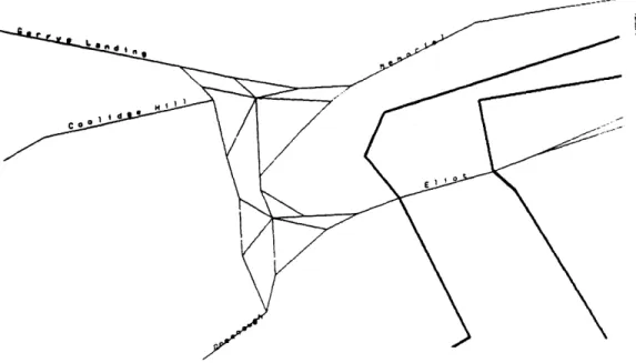
At some forks, one branch is the obvious next branch. An example is the connection between Memorial Drive, Brookline Street, and the Boston University Bridge. The right branch (going either up or down the Charles River) leads to a rotary from which one may turn onto Brookline Street or the bridge. The left branch leads up and over the rotary. Most (not all) of those whose routes stayed on Memorial Drive passed through this fork without comment. The left branch is the obvious place to go because it has two lanes and is more straight. An example of a fork without an obvious branch is the connection between Memorial Drive and Massachusetts Avenue, near MIT. Here the left branch leads underneath Massachusetts Avenue, and the right branch forces a turn. Even though the left branch is wider than the right, it is not obvious, perhaps because it departs at a steeper angle than the right branch does. Subjects always were explicit about
which branch to take.
2.6
Example Instructions
Here is one of the transcriptions, and a map showing the route. I have adapted
the notation system of Gail Jefferson [72]. This notation system is specialized for study of interaction between speakers. Words are spelled the way they sound, not the way they would be written, so, e.g. "going to" is written as "gonna", when so pronounced. The notation is explained in table 2.2. I have chosen to capitalize proper nouns to make the account easier to read.
symbol curly braces single parenthesi double parenthes left bracket colon meaning indicate location
hesitation or cut-off speech the driver is speaking the passenger is speaking an untimed pause
s enclose uncertain words is vocal style or non-vocal sound
marks simultaneous speech marks extended length syllable
Table 2.2: Notation system for transcriptions
This route goes from the parking garage at 12 Albany Street, Cambridge, to a garage at Glenville Terrace in Allston.
{at 12 Albany}
1 R: and at the stop sign take a right on Main {on Main Street}
2 R: and you'll keep going straight
3 R: this is Tech Square
4 L: mhhmm
6 L: hmm
7 R: so keep going straight past Ames Street 8 R: dont hit the pedestrians
9 L: ((in silly voice)) We want to die:: 10 R: (keep) going straight
11 R: merge here I believe with Broadway
12 Go straight at the stop sign
13 and then you're going to take a right on Memorial
14 (at the) sign that says Memorial Drive West {on Memorial}
15 you can see uh that you're driving right along the river and 16 Boston is on the other side on the left
17 L: mhmm
18 L: what part of Cambridge are we in
19 R: we're in Kendall Square 0 area 0
20 and basically we're passing by the uh passing by MIT the long way 21 much of it is right on Memorial Drive
22 L: mhmm
23 L: how long will I be on this street
24 R: oh about another () mile mile and a half
25 L: ((unclear))
{approaching Massachusetts Avenue fork}
26 R: you bear to the left here and go under the bridge 27 under the overpass I guess
28 L: uhhuh
((noise of tires on pavement))
29 R: down the ways a bit we're gonna cross over the river to our left 30 umm cross a bridge called the B U Bridge
32 R: you're gonna want to get into your right lane
33 R: and you're gonna bear off () to the right here
0
34 where it says route 2 ()
35 and this is a traffic circle
36 you're gonna go around three quarters of the way
37 and head across the bridge
38 R: stay in the right lane here cause you're gonna take a right 39 L: uh huh
40 R: so we're leaving Cambridge and going into Boston now 41 and uh Boston University is right around here
42 right along the river 43 L: mhmm
44 R: and we'll be driving past () some of BUs buildings
45 R: you're gonna take the first right here on Commonwealth () Ave 46 R: so we're gonna be following Commonwealth () for a while
47 an:d in maybe a mile it bears off to the left 48 and we'll we'll follow it to the left
{Commonwealth and Babcock}
49 R: might need to get into the left lane for this uh bearing left
50 ()
51 in fact it bears left here
52 ()
53 middle or left lane
54 R: So I guess a good thing to remember for the directions here
55 is you follow the Green line around (when) you bear left
56 R: now we're gonna pass Harvard Ave 57 and its gonna be the next
58 (no) maybe we're gonna turn onto Harvard Ave
60 gonna turn right () on Harvard
61 an:d that it be coming up right here?
62 yes its the first right then after you bear left
{Commonwealth and Harvard 6:01}
63 R: okay now we're gonna turn right on the first street
64 which I believe is (glenough)
65 and this is our destination ()
66 towards the end of the street
67 L: here's Glenville on the left
[
68 R: Glen- Glenville
69 L: This street here? 70 R: yes
71 L: Glenville Terrace 72 R: Glenville Terrace
Figure 2-2: Map for sample route
Part II
Implementation of the Back Seat
Driver
Chapter 3
Cartography
Every navigation system requires a street map. The Back Seat Driver's map originated as a DIME (Dual Independent Map Encoding) file, a map format in-vented by the US Census Bureau for the 1980 census. Although DIME maps are a useful beginning for navigation, there are problems inherent in the structure which make them unsuited for route finding and route description. One aim of the re-search here is to determine what information must be in a map database used for these purposes.
The first section of this chapter describes the DIME map format. The second section shows why DIME is not sufficient for route finding or route description. The third section describes the extensions to the map required for the Back Seat Driver, and the final section compares these extensions with those in other navigation systems.
3.1
DIME format
map should be a vector representation, not a raster picture. One reason is economy of storage: the vector representation takes far less room. But the main reason is that only a vector representation is suitable for programmed manipulation. The mathematical basis for route finding is graph theory, not tracing lines on a picture. Even when the intended application is simply to show a picture, the vector repre-sentation allows a program to display the map at a variety of scales, detail, and orientation, to highlight significant information and remove unimportant features. The basic unit of the DIME file is the segment. A segment is a portion of a street (or other linear feature such as a railroad, property line, or shoreline) chosen to be small enough that it is a straight line and has no intersection with any other segment except at its endpoints. The two endpoints are designated FROM and TO. If the segment is a street segment (as opposed to, say, a railroad) and has addresses on it, then the FROM endpoint is the one with the lowest address. Otherwise, the endpoint labels are chosen arbitrarily. A segment has two sides, left and right. The sides are chosen with respect to travel from the FROM endpoint to the TO endpoint.
Attributes of a segment include:
* its name (40 characters)
* its "type" (a one to four character abbreviation such as "ST")
* longitude and latitude of the endpoints * ZIP code for each side
* addresses for each endpoint and each side
* list of segments connected at each endpoint
A program using DIME can find the location of an address along the segment by interpolating the addresses between the low and high addresses for the two endpoints.
3.2
The limits of DIME
The form and content of a map database depend upon the purpose for which you intend to use it. The DIME file was invented to allow the Census Bureau to determine the proper census tract for any given address in the USA, and for no other purpose. The DIME file is well suited to determining the absolute position of a building from its street address. But the DIME database is not sufficient for route finding, and it only marginal for generating route descriptions. The problems with DIME fall into two categories:
3.2.1
The model of connection is deficient
The DIME file indicates that two segments are physically connected (that is, they touch), but not whether they are legally connected (i.e. it is legal to travel from one to the other). Legal connectivity is crucial for route finding, unless we only want to go to jail or the hospital. It must be explicit. Legal connectivity does not replace physical connectivity. Only legal connectivity is needed for route
find-ing, but route description requires information about physical connections as well. Physical connectivity also affects route finding directly when seeking the simplest route, since ease of description is determined in part by physical connectivity.
The DIME file is a planar graph. This means that no two segments can cross except at an intersection, so there is no way to correctly represent, say, an overpass. The DIME format represents an overpass by "breaking" both streets at the point where they cross, and creating a fictitious intersection even though the segments do not touch in reality. These false intersections are particularly troublesome since DIME does not represent legal connectivity, so it appears possible and legal for a car to jump straight up and turn onto the overpass.
3.2.2
Position resolution is inadequate
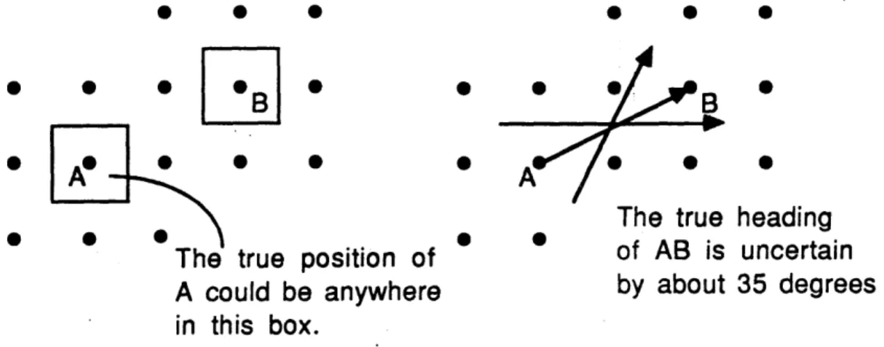
Coordinates in DIME are stored in ten thousandths of a degree. This means that the position of an endpoint in the map differs from the true position by as much as 6.5 meters in latitude (north/south) and 5 meters in longitude at the latitude of Boston. (The size of a degree of longitude depends upon latitude, since longitude lines converge at the poles.) This inherent position error causes problems because it introduces error in length and in heading. See figure 3-1 for an illustration. Here, the points A and B could have been located anywhere within
e
B
S0 0 0B
e
A
*A
0The true heading
The true position of
of AB is uncertain
A could be anywhere
by about 35 degrees
in this box.
Figure 3-1: Position roundoff makes headings uncertain
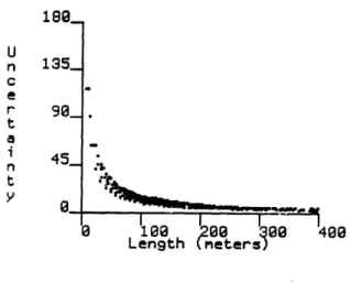
the boxes surrounding them. Depending where A and B really are, the heading of line AB changes by almost 90 degrees. Figure 3-2 shows how the accuracy in heading decreases as segments become shorter.
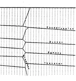
Uncertainty in heading causes uncertainty in the angle between two segments. A straight street can appear to wobble if it is made of many short segments. See for instance Pleasant Street in figure 3-3. The dots in this figure are the possible coordinate locations. Pleasant Street lies in between two columns, so it wobbles back and forth.
U n 135_ C e r 90_ t a i 45_ n:3 0 0 100 200 300 400 Length meters
Figure 3-2: Short segments have less angular resolution
Segment wobble causes problems for the route finder, makes it hard to generate correct descriptions, and interferes with position determination. A straight road that "wobbles" will appear to be slower than one that does not because cars must slow down for turns. The Back Seat Driver corrects for this by assuming that the angle between two streets is the smallest possible value. This means it sometimes overestimates the speed it can travel through an intersection. Uncertainty in the angle of segments at an intersection also makes it difficult to describe the intersec-)n correctly. After all, the difference between going straight and turning is "just a matter of degree". As a result, the Back Seat Driver sometimes uses the verb "bear" where "turn" would be more appropriate, because it underestimates the angle of the intersection. Segment wobble also interferes with navigation because it makes it difficult to compare compass headings with the heading of a street.
3.2.3
The forthcoming TIGER format is better, but not
enough
Figure 3-3: Coordinate rounding makes streets seem to wobble
has designed a new map format known as TIGER (Topologically Integrated Geo-graphic Encoding and Referencing). This format has several improvements from the DIME format[79, 52, 421. The map format is structured to permit automated consistency checking, so it should be more reliable[13, 54]. TIGER coordinates have two more decimal places of precision (bringing accuracy to something like four inches), and the segment representation includes "curve vectors" so that a segment need no longer be a straight line. Two dimensional areas are explicitly represented as closed polygons, which will make it much easier to tell whether a route crosses a river. The database includes point landmarks (fire towers, churches, schools) and "Key Geographic Locations" (mostly commercial buildings)[53] and this will make it easier to find locations and give directions. But the TIGER file is still a planar graph and has only physical connections, so it will not be sufficient for route finding. TIGER maps will be an important component of future navigation programs because they are more up to date and more accurate, but will still be insufficient. Those who wish to use TIGER files will have to obtain and represent connectivity information in some other way.
3.3
A better map
Implementing the Back Seat Driver required me to extend the map format. Each extension described here is used in one or more ways by the Back Seat Driver. Since I have not yet described all the features of the Back Seat Driver in detail, it may not be clear why certain extensions were required. I ask the reader's patience if certain decisions seem unmotivated.
3.3.1
Legal connectivity
The most significant addition is an explicit representation of legal connectivity. This is crucial for finding routes. At each endpoint of the segment is a list of all segments which are legally accessible from that endpoint. This list allows the route finder to consider only legal paths. Although this change is easy to implement, it does not seem to have been included in any other navigation system.
3.4
Additional segment attributes
The DIME file records a small amount of information about the segment. I found it useful to add additional attributes to the segment to make better descrip-tions. These new attributes are:
e street quality 9 divided roads e signs
* other landmarks * traffic lights
e stop signs
9
lane information * speed limitThe first four were added for Direction Assistance, the remainder for the Back Seat Driver.
3.4.1
Quality combines size and speed of a segment
The street quality is a number from 1 ("super") to 4 ("bad") which combines the ease of locating and following the street and the expected rate of travel along it. Super streets are the access highways (e.g. the Massachusetts Turnpike, and most of Storrow Drive, but not Memorial Drive). Figure 3-4 shows the network of super streets. In general, the "super" streets are well known, though perhaps not by their correct name. The "bad" streets may also be well known, to local residents, but not by name. (For instance, see "Back Street" on page 31.) The street quality attribute affects the route finder and the route describer. The route finder ordinarily prefers the street of highest quality. The route describer uses the quality of a street in several ways, described below.
3.4.2
Expanded street classifications
It is useful to have a richer taxonomy of street types than that provided by DIME. There are five categories of streets: ordinary, rotary, access ramp, underpass, tunnel, and bridge. There are also four categories of non-streets: railroad, water, alley and walkway.
A rotary (or roundabout, or traffic circle) is a kind of intersection in the form of a one way circular road (figure 3-5). Traffic enters and exits the rotary on lines