Between Nature and Artifice: The Landscape Architecture Research Office (1966-1979)
by
Catherine F. McMahon
Bachelor of Fine Art Rhode Island School of Design, 2003
Bachelor of Architecture Rhode Island School of Design, 2003
Submitted to the Department of Architecture in Partial Fulfillment of the Requirements of the Degree of Master of Science in Architecture Studies
at the
Massachusetts Institute of Technology
June 2009
©Massachusetts Institute of Technology. All Rights Reserved
The author hereby grants to MIT permission to reproduce and to distribute publicly paper and electronic copies of this thesis document in whole or in part in any medium now known or hereafter created.
Signature of Author:.
N Department of Architecture
May 21, 2009
Certified by:... Arindam Dutta
AssociateCertified by: ... ...Professor of the History of Ar chi tecturedam utta Associate Professor of the History of Architecture
Accepted by:...
KU
MASSACHUSETTS INSTITUTE OF TECHNOLOGYJUN
0
8 2009
L BRARIES Julian Beinart Professor of Architecture Chair of the Department Committee on Graduate StudentsBetween Nature and Artifice: The Landscape Architecture Research Office (1966-1979) by
Catherine F. McMahon
Submitted to the Department of Architecture on March 21st, 2009 in Partial Fulfillment of the Requirements for the Degree of Master of Science in
Architecture Studies.
ABSTRACT
Cambridge in the 1960s was a locus of experimentation and research in new computing technologies -from the production of transportation models for New England to the design of war games simulating the vagaries of the terrain in Vietnam. One research group, working in the nascent field of computer cartography, was formed in the Department of Landscape Architecture at Harvard University. The Landscape Architecture Research Office (1966-1979) represented a radical departure from existing practices within the discipline. At this time, NASA was making its first moves towards erecting image infrastructures in space-able to beam back streams of pictures describing the earth in seemingly infinite detail. The instrumental extension of man into outer space served to remake an imagination of landscape; and the research office, banking on the promise held out by satellites and computers, was preparing a technological ground to receive this new vision.
This thesis will examine two of their early projects, the first a study that utilizes a computer mapping program (GRID), to draw multiple disciplinary objectives, from physical geography to governance to aesthetics, into the same syntactical register-using the map as a technological armature to craft a new theory of landscape. The second project was an experimental studio run by two of LARO's researchers, Carl Steinitz and Peter Rogers, in which they attempt to simulate the function of an imagined computer system able to model all the interconnected processes of urbanization. Using maps and students as analogue parts they proceeded to deploy game theory to play-act the computer's operational roles. By doing this, Steinitz and Rogers sought to delimit the role of designer or architect within the mechanisms of a representational system. While the work of LARO was influential in the development of what is known as GIS today, I wish to pull this historical episode out of the technological continuum-looking instead at this moment of profound indeterminacy and speculation over the role that technology could play in the process of design.
Thesis Advisor: Arindam Dutta
Thesis Advisor: Arindam Dutta
Title: Associate Professor of the History of Architecture Thesis Reader: Mark Jarzombek
Title: Professor of the History and Theory of Architecture Associate Dean, School of Architecture and Planning
Special thanks to:
Arindam Dutta, Mark Jarzombek, John Milton McMahon III, Lorraine McMahon, David McMahon, John Milton McMahon IV, (E, A, and B, My three new brothers), Shiben Banerji, Ateya Khorakiwala, & Anthony Acciavatti.
Image: Comparative Study of Resource Ana sis Methods (Printed by Harvard University)
Introduction
The point of departure for this research was a text titled, A Comparative Study of
Resource Analysis Methods, that I happened upon while searching the shelves in the MIT's
Rotch library. The Comparative Study is a dry, heavy book, covered in the library's standard green book cloth; it is made up of approximately four hundred, single-sided, mimeographed pages. Bound into the front of the text is a letter, dated July 14, 1969, and addressed to Mr. Raymond Cason of the Army Corps of Engineers; the letter simply explains that the
following pages comprise the final report fulfilling the requirements of research contract no. "DACW 33-68-DC-0152," not expanding upon the nature of this contract. Inside one finds a hand-typed report compiling well over one hundred maps of the Charles River Watershed in the southwest region of Massachusetts. Yet, these are not maps in the ordinary sense-floating in the center of each yellowed page is a four by five inch grid made up of singular binary symbols pressed into the page. These symbols aggregate into strange and clumsy
topographical patterns, and the watershed emerges as a site thickened through black marks of data. They do not reconstruct the landscape as a navigable terrain, but rather attempt to render the landscape through categorical judgments, from aesthetics to land-use suitability to geology. Looking at the care with which each page was systematized, labeled, and laid out,
and the sense of authority invested in each image, it is clear that these maps represented a cutting-edge of technology in the 1960s. When I found the Comparative Study, I had been doing research into the origins of Geographic Information Systems (GIS); I was searching for the genealogical strains of the technology that lay within analogue methods for overlay mapping, explored by landscape architects in the 1950s and '60s. The Comparative Study, while contemporary to some of the material I had been looking at, went a step
beyond--moving into the sparsely populated territory of the digital terrain. Today, the fully
naturalized use of technologies like GIS (across many disciplinary realms), belies the risk of failure that permeated this moment in the 1960s and '70s. In this sense, I wish to pull this historical episode out of the technological continuum-looking instead at this moment of both profound indeterminacy and intense speculation over the role that technology could play in the process of design.
Looking at this text, one sees multiple forces and ideas converging, from new
conceptions of the landscape with the advent of space technology, to a rapidly suburbanizing American landscape, to an interest in systems analysis and simulation models. One author recounts that at this time, "system which is represented in the simulation model might be as broad as the international system or as narrow as the decision system of a department store buyer."' The Comparative Study was produced by an organization called The Landscape Architecture Research Office (LARO). LARO was affiliated with the Department of
Landscape Architecture and Laboratory for Computer Graphics and Spatial Analysis (LCG), at Harvard University. Both LARO and LCG were experimenting with the latest advances in computer cartography; the lab was focused primarily on the technological development and refinement of computer mapping techniques, whereas the research office sought specific applications for the technology in response to emerging issues within the discipline of landscape architecture. The research office was formed in 1966-and lasted until 1979, marking an era that saw the Department of Landscape Architecture investing heavily in the promise of new technologies. At this time, they developed a curriculum based largely on the use of the computer. Looking at old GSD course registers one can see that this curriculum predates the computer's arrival in the Department of Architecture by almost twenty years.2 With the incorporation of the singular architect into a group of designers working together on common problems, the research office served as a space to translate the authorial idiosyncrasy of existing practice into forms of production (reports, studies, etc.) that could transcend the figure of the individual. Presenting their material in formats similar
to those used by scientists, the researchers were trying to strike a disinterested pose, attempting to invest their work with the sense of transparency and authority that lay in modes of scientific production. During its almost fifteen year existence, LARO embarked
on a number of studies, from the documentation of pre-existing methods for resource analysis (the Comparative Study), to the lengthy construction of a multifaceted computer model-capturing a miniature world in programming language and linear
equations-1 Coplin, William D., Simulation in the Study of Politics, (Chicago: Markham Publishing Company, 1968), p.2
2 Information taken from, "Harvard Graduate School of Design Course Registers" (1960-1985) Loeb Special Collections.
LARO's researchers attempted to simulate the qualitative as well as the quantitative aspects of the processes of urbanization. Beyond satisfying the terms of their research grants, the format of the report allowed the researchers to document both the way they organized and conducted their research, as well as the design process they underwent when building simulation models. They did not work on design solutions for any particular locale, but rather they developed methods for the description of site. With an emphasis on these types of analytic and representational methods, LARO was operating in a mediatory space, designing the instruments to be used in design. The designer (working in the research group) thus becomes twice removed from the object (building, city, region, park, etc.) and design itself becomes the subject under question.
The issue of authorship raises the question: Who was working in the research office? The Comparative Stud yields up four names, Carl Stemitz3, Timothy Murray, David Sinton,
3 Carl Steinitz, was among the few key figures that were able to bring together the different
disciplinary prerogatives and people, between the lab, the research office, and the departments within the design school. This was due in large part to his diverse set of
interests-that were united through the morphism of systems studies. In 1966, Steinitz was a doctoral student of Kevin Lynch's, finishing his dissertation in city and regional planning (with a focus on Urban Design) at MIT; it was also at this time that he began working with the lab as a research assistant. His dissertation Congruence and Meaning: The Influence of
Consistengy between Urban Form andActivity Upon Environmental Knowledge, investigates what he
terms, "environmental meaning." In an article published from the work of the thesis, he writes, "[the research] attempts to demonstrate that there are measurable correspondences--congruences-between urban form and activity, and that the regularities in these
relationships have a major influence on the amounts and kinds of meanings which the environment transmits and which people can acquire."3 The research brings together the notational techniques, and ideas about environmental perception that Lynch's puts forth in the Image of the City, with the mapping techniques he was learning at the lab. In the thesis he generates a framework of computer maps that would allow an individual to communicate their experience of the city, which would then be aggregated with other individual data inputs to render the whole. In addition to this, he developed organizational techniques for building a visual lexicon by creating an atlas of snapshots of each nexus in the city-that were then interpreted for the visual legibility of their elements--in an attempt at
systematizing form making. It was this systematic approach, more so than the specific content of his research (Boston) that allowed him to approach multiple types of problems. Soon after his dissertation was complete in 1967, he was hired to teach in the Department of City and Regional Planning at Harvard, and shortly thereafter moved over to the
Department of Landscape Architecture. He worked towards crossing disciplinary
boundaries to put forward organizational strategies for framing projects that attempted to employ the efforts of multiple disparate actors.
and Douglas Way, who together co-authored the study. The four people, Steinitz and Sinton, professors in the Department of Landscape Architecture, and Murray and Way, their
students, are representative of just a few of the many figures who were involved in research based on early computer mapping at Harvard. Departing from this moment all four co-authors went on pursue diverse paths over time, from further engagement with the profession of landscape architecture to the development of spatial analysis systems in the
commercial sector to political involvement in the growing environmental movement.4 There was a convergence of figures in this place and at this time, all interested in the potentials held by the computer map, and the possibilities for spatial analysis. The reports downplay
authorship, obscuring the voice of each individual, in an effort to create a singular
authoritative narrative-though their individuality occasionally breaks through in the texts-revealing their struggle to construct these apparently seamless practices and technologies. These moments also reveal the stakes involved for the researchers, who had cantilevered themselves beyond the conventions of professional practice to attempt to redefine the discipline of landscape architecture.
The Landscape Architecture Research Office represents a convergence of interests, some coming from within the discipline of landscape architecture itself and others coming
from outside-the stretch of Mass. Ave between Harvard and MIT saw the traffic of many kinds of activities and ideas in systems analysis, computing, social science, and the
institutionalization of advanced research at this time. This thesis looks at the work of LARO in light of both the institutional history of landscape architecture at Harvard and the status
of the discipline in the 1960s, when the office was formed, as well as the other activities
4 Historian Melanie Simo recounts the career of Douglas Way as an example of the kind of elasticity in employment that these figures, interested in both landscape and technology, encountered. Way was particularly interested in aerial photo interpretation. She explains that Way, after his time in Cambridge, went on to receive a PhD in geography from Clark
University in Worcester, and to become the Chair of the Department of Landscape at Ohio State University. She then explains that, he was recruited to serve on Vice-President Al Gore's Environmental Task Force, "working with the CIA's recently declassified satellite photos." And that as a part of this politically engaged work he went to Siberia in the 1990s to "get the intelligence agencies of Russian and the United States to cooperate on ecological assessments." Simo, Melanie L., The Coalescing of Different Forces and Ideas: A History of Landscape
Architecture at Harvard, 1900-1999, (Cambridge: Harvard University Graduate School of
occurring in Cambridge at this time -that were influential in shaping LARO's discourse and working methods.
At this time, NASA was making its first moves towards erecting image
infrastructures in space-able to beam back streams of pictures describing the earth in seemingly infinite detail. The instrumental extension of man into outer space served to remake an imagination of landscape; and the research office, banking on the promise held out by satellites and computers, was preparing a technological ground to receive this new vision.
Image: Model of LANDSAT 1 Satellite (www.nasa.gov)
In Cambridge, there were a number of individuals interested in the potentials held by space, not outer-space per se, but rather the ability to understand things through proximal relations-that one can see in the nascent practices of both in systems analysis and spatial
analysis. The psychologist and systems theorist, Herbert Simon, was widely influential at this time. In his book, The Sciences of the Artificial, published in 1969, design is identified as a process that is able to unify the natural and artificial into a new class of objects, he writes:
"If science is to encompass these objects and phenomena in which human purpose as well as natural law are embodied, it must have means for relating these two disparate components. The character of these means and their implications for certain areas of knowledge- economics, psychology, and design in particular- are the central concern of this book."5
Science (as opposed to design) must recreate knowledge of these objects discursively, by employing the systematic "means" to identify difference between nature and artifice, as well as the testable relation between the two. He proposes that one study design, in
engineering, or architecture, or medicine, or management, as a way to understand the tactics these professions develop to direct processes in the landscape, or the company, or even in the body. At this time, simulation becomes a critical tool for social scientists to bring a form
of measure to these interactions. Design is itself is described by Simon as possessing a directionality of purpose, he writes, that these professions are "concerned not with the necessary but with the contingent- not with how things are but with how they might be-in short, with design."6 The study of analysis by the researchers at LARO, bordered on the edge of creating a science of design-and was subsequently translated in the form of new representational technologies. The researchers at LARO focused on analytic method in an
attempt to assume a degree of transparency as they developed mapping technology, yet, representation should also be understood as a tactic developed to direct processes in the
landscape, and to this end they were responsible to design.
Denis Cosgrove, the recently deceased professor of geography at the University of California, Los Angeles and noted landscape theorist wrote that "Conceptually, the map has either preceded the physical presence of the city or served to regulate and coordinate its continued existence."7 He goes on to explain that the map, as a representational moment,
occupies two distinct relations to change. In the first it functions in a fashion similar to the plan, laying the grounds upon which change will accrue, and in the second, as a regulatory
function, it mediates between the past and the future acting as at the point of collapse between continuity and change. Both concepts allow instrumentalized images and representational strategies for mapping to be understood as technologies that mediate between the subject that produces them and the subjectivity produced through them. Building upon this, one asks, in what way does the representation of a certain field of knowledge produce both technology and discipline simultaneously?
6 Simon, p.xi
7 Cosgrove, Dennis, Else/Where Mapping- New Cartographies ofNetworks and Territories, Janet Abrams and Peter Hall, eds., (Minneapolis: U. of Minnesota Design Institute, 2006), p.148
Chapter 1: The Landscape Architecture Research Office
From the late '50s onward the schools of architecture and planning at both Harvard and MIT would see a proliferation of research offices and laboratories. Paralleling the organizational schemas for securing funding and generating studies traditionally found in
scientific disciplines, these groups offered a site of production distinct from the studio.
The Lab for Computer Graphics and Spatial Analysis:
In 1965 and 1966, respectively, the Laboratory for Computer Graphics and Spatial Analysis (LCG) and the Landscape Architecture Research Office were formed at Harvard. Both lab and office were intimately connected, yet, as was noted earlier, LARO operated under the aegis of the Department of Landscape Architecture, whereas the lab was
independent from any departmental affiliation and was merely placed under the umbrella of the design school. This allowed the lab to become not only a site of experimentation in computer cartography, but also a central locus for those individuals from a wide array of disciplines who had an interest in computer mapping to gather. Historically the lab is considered to be one of the major sites of development in the technology that would later become GIS as we know it today. In the '60s an interest in computer mapping using time-share computers had arisen across multiple sectors, from the echelons of the military or of the federal government, where that interest was formalized into large research programs, down to university students tinkering with technological components they could either pick-up or make themselves in order to improve map making techniques.8 In a history of the
s Nicholas Chrisman's history Charting the Unknown: How Computer Mapping at Harvard Became
GIS (ESRI Press: Redlands California, 2006), documents the institutional histories of the
Laboratory for Computer Graphics and Spatial Analysis at Harvard. Chrisman was himself was a researcher affiliated with the lab, thus, he provides first hand accounts along with archival reconstructions of the lab's history. Enclosed with the text is a DVD of current day interviews with many individuals who were either students or researchers at the lab in
development of computer mapping at Harvard, a former lab researcher, Nicolas Chrisman, who today is a professor in geography at Universite Laval, Quebec, notes that many of these interested individuals found their way into the lab for a visit or to stay on and work, at one
point or another.9
Id Cp . : I
Image: Ohio River Sediment Deposits, Lab for Computer Graphics and Spatial Analysis (Printed by Harvard University, 1966-1972)
Image: Contours, Lab for Computer Graphics and Spatial Analysis (Printed by Harvard University, 1966-1972)
the1960s and 70s. These interviews provide critical insight into the basic curiosity in computer maps that many of these figures possessed, and experimented with in individual ways prior to coming to the lab.
9 Chrisman, Interviews, (DVD)
Image: 3d Maps, Lab for Computer Graphics and Spatial Analysis (Printed by Harvard University, 1966-1972)
Like institutions or groups formed to conduct scientific research, the lab was funded
by a number of patrons outside the university. When the lab began it was funded with a
fairly large sum of money from the Ford Foundation, whose priorities ranged from an interest in housing and urbanism to setting an agenda for international education within the university.10
Howard Fisher, architect and pedagogue from Northwestern University, in Chicago, was the founder. With his own ideas about improving the technical aspects of pre-existing computer mapping techniques, Fisher had been able to secure these funds prior to
10 Sutton, Francis X., "The Ford Foundation and Columbia," University Seminar on Columbia University, 16 November 1999.
approaching Harvard with the idea of setting up a lab. " While the lab was in operation the list of external sponsors would grow to include, the National Science Foundation, the U.S. Bureau of the Census, the U.S. Geological Survey, NASA, the U.S. Defense Intelligence Agency, the U.S. Defense Mapping Agency, the U.S. Department of Agriculture, the Federal Aviation Administration, and the Executive Office of the President.12 Many of these
sponsors funded projects that were then used by the lab as case studies to hone their
techniques for mapping and the graphic display of information. This in turn, allowed for the technology to develop as the result of collaboration; yet the broad range of projects cast a wide net, and did not narrow the lab's work to a singular form of disciplinary exercise."
Fisher's role was to launch the lab and bring issues of computer mapping to the fore by institutionalizing this type of research within a school of design. There were multiple subsequent directors of the lab over its approximately fifteen-year life span-following Fisher was William Warntz, a theoretical geographer in the Department of City and Regional Planning.14 A report produced at a late stage in the lab's life, by two of its researchers,
Geoffrey Dutton and Jacqueline Cohen, notes that projects under Wamtz "[...] included
" When Fisher came to Harvard, he had been retired for quite some time from a long professional career of practicing architecture and was teaching at Northwestern University in Chicago. Fisher, was both a technological innovator and entrepreneur. On July 4, 1932 Time Magazine called him "both a technician and theorist in architecture," due to his experiments in pre-fabricated housing techniques, that he had successfully formed into a company called General House Inc. His interests were multivalent and upon encountering the most current mapping techniques, displayed at a workshop given by computer
cartographer Edgar Horwood, he decided to attempt his own, improved versions. He used his program SYMAP (SYNagraphic MAPping) to secure funds from the Ford Foundation that after some political setbacks, eventually found a home at Harvard in the form of the Laboratory for Computer Graphics and Spatial Analysis. For Fisher, an interest in computer mapping can be seen as emerging from a broader interest in developing technological
solutions to architectural problems, rather than from the disciplinary influences (such as geography) that will be seen as the underpinnings for other figures drive towards developing computer cartography. A look at Fisher also reveals just one of the diverse sets of figures flocking to Cambridge, to develop not one singular technology but a group of technologies centered around the computer map and simulation. Source:
(http://www.time.com/time/magazine/article/0,9171,743936-2,00.html), and Chrisman, Nicolas, Charting the Unknown: How Computer Mapping at Harvard Became GIS (ESRI Press: Redlands California, 2006)
12 Dutton, Geoffrey, and Jacqueline Cohen, The Laboratoy: An Historical Overview (1965-81) (http://lcgsa.mannlib.cornell.edu/lcgsa/uploads/lcghist22all.pdf)
13 Ibid. 14 Ibid.
hierarchical structures in human environments (river and central-place systems), geographic regularities in the distribution of population and income, minimum-path problems, and the topology of landforms and statistical surfaces."'5 The empirical and quantitative problems of the failing discipline of geography, found new life in the contours, patterns, boundaries, and proximities, of the map itself, with the aid of the computer. 6 Dutton and Cohen write, "The Laboratory's researchers came to appreciate that the elegance and economy with which spatial phenomena- and space itself- is described in software affects the power of that
software to map and manage information."'7 In this sense, the technology was able to fulfill any number of roles and in the subsequent years of the lab, production became primarily focused on software development. As the funding from outside sources dried up, the lab turned to the packaging and selling of its software via mail-order service, and circulating serial publications describing new innovations in technique. It is largely due to these two forms of production, software and serial, which allowed the lab to bring the potentials of computer mapping to a large audience, and gain widespread recognition. 18
15 Ibid.
16 The closure of the Geography department at Harvard University in 1948 by university President James Conant, is widely held to epitomize the "crisis" in the discipline as it sought ways to develop from an empirical or descriptive discipline to one that would have recourse
in scientific method to engage in a more theoretical project. The geography department at Dartmouth College remained a locus of these activities, while other universities were jettisoning their departments of geography left and right. In the 50s and 60s the move towards quantitative methods, in conjunction with the development of computer mapping technologies allowed the discipline to begin to close the gap between its status and that of other sciences. This along with the rise of regional science in the United States allowed it to regain a portion of the ground it had lost within academic institutions.
17 Dutton, Geoffrey, and Jacqueline Cohen, The Laboratogy: An Historical Overview (1965-81) (http://lcgsa.mannlib.cornell.edu/lcgsa/uploads/lcghist22all.pdf)
18 Charles and Ray Eames featured the work of the lab in a film on Photography and the City in
1969.
Nicholas Negroponte also mentions the lab and SYMAP in his book, The Architecture
Machine, (Cambridge: MIT Press, 1970).
Contemporary histories also cite the Lab's work, such as:
Foresman, Timothy W., ed., The History of Geographic Information Systems: Perspectives from the
Image: Income Density / Income Potential, Lab for Computer Graphics and Spatial Analysis (Printed by Harvard University, 1966-1972)
In the same report, Dutton and Cohen, outline the core objectives of the laboratory. A reading of these objectives reveals the variegated set of priorities the researchers working in the lab had to negotiate. They write:
"Despite some lean years, the activities of the Laboratory have continued to grow in scale and sophistication. Its central concerns, however, have remained remarkably constant. Simply stated these are:
1. Graphic display of spatial information. 2. Geographic data management and analysis. 3. Applications of techniques.
4. Dissemination of search results."'"
The last two objectives, those of application and dissemination, can be considered together. In other words, in the process of framing use, the subject of the user is produced. In considering the user, questions of dissemination, or the best method for transferring
knowledge are at stake. It is in these last two areas of production, that the research activities of the lab and the office begin to differentiate. As Chrisman explains, LARO began as a group of individuals working on specific problems within the lab. Focusing on potential
applications, they drew emerging concerns about the environmental planning into the lab; specifically, issues that were of interest to the professors in the department of landscape architecture.2 0 As the former chair of the department, Charles W. Harris, noted in a recent interview, "The Department of Landscape Architecture had been studying large regional landscapes for several years but was seeking a more systematic method to assemble, analyze, and synthesize this information."21 In Harris' reflection back onto the moment that
landscape architecture and computer cartography came together, he uses terms that posit the organizational effects of systems thought (belonging to the realm of computer mapping), as
the inevitable answers to the questions that the discipline of landscape architecture sought to ask at this time. In other words, he projects the description of their project backwards from the ends it took, eliding the leap in logics that had to occur at the point the cartographers and landscape architects found that there was something to be gained from one another through collaboration.
In the archive of reports, interviews, and mentions in institutional histories, one encounters many names associated with the research office, beyond the four names mentioned in the introduction, Steinitz, Sinton, Way, and Murray, one finds, Hideo Sasaki founder of the large interdisciplinary design firm, Sasaki Associates, who was chair of the Department of Landscape architecture at the time LARO was formed; Charles Harris, pedagogue and successor to Sasaki as chair of the department and head of the office; Walter Isard, an economist who went on to found the regional science program at University of Pennsylvania; Peter Hornbeck, professor of ecology in the Department of Landscape
Architecture; Peter Rogers, a water economist and planner from the Department of City and Regional Planning; David Lowenthal, a geographer with a focus in environmental
psychology, who would go on to teach in the geography department at the University College London; James Brown, a specialist in land use and regional economics, who would later chair the Department of City and Regional planning, as well as assume directorship of
the MIT / Harvard Joint Center for Urban Studies; and Jack Dangermond, a student contributor to the Comparative Study, who would go on to found the corporation ESRI, perhaps the largest developer and distributor of GIS software packages today. This list does
20 Chrisman, p.42
21 Interview with Charles W. Harris and Carl Steinitz, conducted via. e-mail by the author on February 17, 2009.
not even touch upon the large number of individuals from other disciplinary realms (law, social science, political science, etc.) who collaborated with the office. Yet, this account is not meant to give a mere litany of names but rather to demonstrate the density of a network of individuals that at times appears diffuse in the archive. Carl Steinitz, mentioned in the introduction, was key in bringing together the lab and the studio in collaboration-beginning with Delmarva.
The Study for Delmarva Peninsula, was a joint effort between the Department of Landscape Architecture, and the Department of City and Regional Planning-beyond bringing together the two departments, Steinitz worked with the studio to organize the analysis of the peninsula through the use of the lab's computer program SYMAP. In the
same year, 1967, the research office (still located in the lab) produced a study titled, Three
Approaches to Resource Analysis Methods, wherein they document the methods used to describe
the landscape of, Angus Hills, a soil scientist and forester from the Ontario Department of Lands and Forests, Phillip Lewis a landscape architect and professor at University of Wisconsin, and Ian McHarg, also landscape architect and professor at the University of Pennsylvania.22 As a forerunner to the Comparative Study of Resource Analysis Methods, this study uses hand-drawn method to re-map and reconstruct the general principles of analysis that they interpreted from each of these three individuals' work. At the time, the three landscape planners were also invited to Harvard to visit and lecture on their method to the researchers, faculty, and the students.
While the studio and the study of Hills, Lewis, McHarg were occurring at the same time, questions of method had not found (and would not necessarily find) a unified answer. Chrisman explains that within the studio:
"The students and faculty doing this project did not adopt any of the three models presented by Hills, Lewis, or McHarg. Perhaps due to the nature of the study area, the environmental constraints were not considered to be sharp black-and-white distinctions. Rather than solutions dictated by environmental constraints alone, this project allowed scope for the broader considerations that were the basis for the student's plans."23
22 Chrisman, p.42-43, and
Belknap, Raymond K. and John G. Furtado, Three Approaches to Resource Analysis Methods, (Cambridge: Harvard University and The Landscape Architecture Research Office, 1967).
The Delmarva project represents a serious attempt to reconstruct the nuance of the object of study inside the walls of the studio through a detailed site analysis-the use of time-consuming and labor intensive data gathering and computing processes reveals the sincerity with which they approached this task. At the same time, the very act of describing an object
sets the limits for what can be imagined, or designed, within the process of proposing a new condition.
Ime Delmara fo Lab RRVRaphics and Spatial Analysis (Printed by Harvard University, 9661972)
Image: Delmarva, Lab for Computer Graphics and Spatial Analysis (Printed by Harvard University, 1966-1972)
, 00
Areas for Conservancy, With the
Assumption that the Primary
Impetus for Conservation Comes
From Agricultural Interests
(60 x 25")
i. i9
Image: Delmarva, Lab for Computer Graphics and Spatial Analysis (Printed by Harvard University, 1966-1972)
Due to his status as a former participant in the lab, Chrisman's text can also be treated as a primary document, in places his narration of events reveals the attitudes held by those engaged furthering this technological enterprise. Contained in the description of the studio cited above, is the implication that there are certain types of landscapes which experience obvious environmental pressures, that when addressed through analysis are able to give greater legibility to methods that rely on making "distinctions" through notions of "environmental constraints," on the other hand, he writes of landscapes with more subtle patterns of difference that don't respond as well to existing methods of environmental analysis. The studio's use of SYMAP is presented as a way that the students and faculty made inroads on this problem. He seems to be mildly critiquing the landscape planner, implying a limited capacity for managing information that forces the imposition of binary
distinctions in the description of landscape (this critique surfaces in the writings published by LARO as well), embodied by this critique is an implicit imagination of the computer as a device that will be able to handle almost infinite volumes of data, and make complex visualizations that will serve to clarify fine-grain decisions and by-pass the limits of the human designer. Chrisman is writing an institutional history of the technological
development of GIS at Harvard, and as such, there are two idealized subjects latent in his narrative, GIS as we know it today, and the imagined future of the technology on the path towards progress. When further explaining the influence McHarg and Lewis had on those in the school he writes, "Both McHarg and Lewis put substantial faith in the integrative role of the designer in looking at the whole and seeing patterns, a role that still defies direct
translation to computer software."24 Again, what is revealed is a hidden desire to replace parts of, or even the whole designer with a corporeal bundle of computer circuitry.
Chrisman's observation about McHarg and Lewis, allows one to ask how the boundaries of the designer's role were being tested at this time, and what aspects of their intelligence were being isolated for replication through technology.
Charles River:
Each of LARO's studies was focused around the same region of the Charles River Watershed. In part this was due to the fact that once they had built a comprehensive database of the region it became useful to use the same database each time. Reports produced by the Army Corps of Engineers suggest another story though, one a study on
Charles River Population and Urbanization, prepared in 1967, and another a Water Resources Development Plan, produced in 1972. The reports frame the import of this region as a part of
what they call "Megalopolis," or the heavily populated area between Boston, New York, and Philadelphia. The USACE suggests that the watershed is an area of intensive growth, and transformation. Suburbanization of this area was proceeding at a rapid pace at this time. In 1954 and 1955 many neighborhoods on both the Boston and Cambridge sides of the river basin were flooded during hurricanes.25
This prompted the USACE to study not only the area flooded but also the whole system of land constituting the watershed, and as historian 24 Chrisman, p.43
25 Haglund, Karl, Inventing the Charles River, (Cambridge: MIT Press, 2002), P.287
Karl Haglund notes, the USACE developed the first only "nonstructural" flood control program in the country at that time.26 Harvard President Nathan M. Pusy headed up the Citizens' Advisory Committee, which was arguably the most influential advisory board to the USACE as they developed their plan. The study describes the CAC as "a body of more than 30 private citizens who collectively represented the industrial, conservationist, educational, recreational, and real estate interests of the watershed area."27 Haglund explains that the USACE eventually bought up 3,252 acres of land, and secured conservation for several thousand more.28 He suggests that these private interests underpinned much of the support and direction of the USACE plan. The USACE used the expertise of those at Harvard and MIT, such as LARO to build simulation models to test their ideas. The USACE presents the flood control plan as a chance to implement a system of management that would be contrary to their usual built control works, which they admit, "have not always been met with uniform public enthusiasm."29 The USACE also acknowledge that, "The public is
anxious to see multiple returns on its investment in the Charles." And that the,
"Implementation of the recommendations presented here offers the watershed population as a whole impressive long-term benefits quite outside the issue of flood protection." 30
Comparative Study of Resource Analysis Methods:
Each of the texts that LARO produced and are examined in this thesis is presented in the form of a report. Thick booklets, compiled by the office, they sit on library shelves at MIT and Harvard (and possibly other unknown libraries), accumulating dust for the most part. What is the value of a technical study from the 1970s today? Outmoded, they reveal the
speculation over the multiple possibilities for a technological project, inherent in the moment of its inception, that no longer exist today. One asks why did the research office, gathering many strong figures into one platform, leave so few marks in the discursive fabric? In this sense, the reports, through the veil of objectivity, attempt to blend into the
26 Haglund, p.285
27 United States Army Corps of Engineers, Charles River Watershed Massachusetts: Main Report
and Attachments, (1972), p.7
28 Haglund, p.285
29 US Army Corps of Engineers, p.i 30 US Army Corps of Engineers, p.8
background of 'facts.' The Charles River Watershed appears in each study reconstituted as a landscape of formulae, cybernetic loops, and like the silt left after flooding, as aggregated
data patterned across the terrain.
Image: Maps, Comparative Study of Resource Anabsis Methods (Printed by Harvard University, 1969)
Image: Chrisman, Nicolas, Charting the Unknown: How ComputerMapping at Harvard Became GIS (ESRI Press: Redlands California, 2006)
Looking at the stack of aged pages in the Comparative Study, each page shows a map, a four by five inch grid of alphanumeric symbols pressed into the page (ten per linear inch), creating dark to light patterns that suggested a characteristic of the landscape such as the distribution of a single element across the site. Amidst these generalized and ungainly marks of data, snake a few linear points of reference (the primary highway network and the rivers); that serve to enhance the believability of the image as a map--anchoring the viewer within the picture through an established representational technique.3 1 The maps were printed on a widely available line printer, and as a former researcher at the LCG, Nicolas Chrisman,
31 Explained on pagel0 of the Comparative Study.
notes, "Each line was printed all at once by the impact of print slugs onto the paper through a carbon ribbon (not so different from the typewriters of the era).32 The process of creating the computerized maps is described by the same author, first the mapmaker, "uses the manual digitizing board to establish coordinates of the controlling points on the 'source
map,' and enters the information on special coding forms," in other words, a special ruler (calibrated to the spacing of the printed alphanumeric symbols) is laid across a traditional map or aerial photo, using the ruler the meaning of the data is encoded by the mapmaker at each point; this is followed by the production of individual punch-cards that are then stacked and brought to the technicians whose job it was to run them through a centrally located time-shared computer; the mapmaker would then come back a day or two later to retrieve his printed map." Each point of the process corresponded to a different thought process or representational paradigm, such that the mapmaker had to envision the landscape through multiple organizational modalities. Due to the significant amount human labor required to produce even the most basic map, the study admits that the values of, "Accuracy and economy of computation are somewhat contradictory."3 4 The slippage that occurs between
the two values points to the nature of the gap that exists between the representation and its object.
To this end, three questions can be asked of the maps in the Comparative Study: What is the subject of the representation? (i.e. city / process of urbanization, distribution of resources / accumulation of value for those resources, etc.); The second question is, what is the object of the representation? In other words what is the sensory or metric relationship, or even direct sensory relationship to the site of analysis and projection? The third question asks, what is the representation's relationship to change? In other words, what are the potentials (and limits) for design located within the representation?
The initial purpose the authors assign to the Comparative Study was two-fold, the first was to gather information about individual approaches to resource analysis for
comparison (collected from 16 different actors in total), the second was to test a computer mapping program (GRID) for its ability to incorporate and reorder all of the priorities brought to the regional planning of landscape. The different individuals ranged from
32 Chrisman, Charting the Unknown, p.26 33 Chrisman, Charting the Unknown, p.2 4
34 Steinitz, Comparative Study, p.9
landscape architect (Richard Toth, Ervin Zube, Ian McHarg, Philip H. Lewis Jr., etc.) governmental agency (US Army Corps of Engineers, Soil Conservation Services, etc.), planners and planning commissions (Chester County Planning Commission), geographers, engineers, and interestingly, other computer simulation models, that were assumed to possess enough cybernetic intelligence on their own to constitute individual actors (PARIS: The State of California, and RECSYS: The State of Michigan). After gathering information about each individual (or group) the researchers then decided how to interpret their
individual methods within the terms of the system. In other words, each individual's (or group's) practices engaging different representational techniques, from transparent overlay maps, computer simulations, sketches, diagrams, reports, etc., were interpreted by
researchers and remade through the logic of GRID-generating computer maps of a uniform appearance, save the distribution of data. GRID was understood as a language that could mediate and replicate (to some degree) these varying practices. Difference between each designer is not determined in the aesthetic register of representation technique, but rather the way in which each individual establishes criteria for analysis and design. This issue is addressed within the opening paragraph of the introduction, the authors write:
Given increasing public awareness of the need for resource use policies which will minimize the inevitable conflicts among the various demands for land, resource analysts, planners, and designers are challenged to go beyond the level of
individuality and towards a level of understanding which approaches the theoretical.35 This citation reveals the central contradiction in the study, where on the one hand the authors purport to be generating an umbrella under which a multitude of practices can exist, in other words, the analytic technology they are producing (not just the computer program, but their interpretive method as well) postures as if disinterested, transparently mediating multiple agendas. On the other hand, this intent is belied when they express the desire to "minimize the inevitable conflicts," that arise in making land-use decisions. This reveals that contrary to what they may imagine their project to be, they were not only speaking about ameliorating misunderstandings or incompatibilities amongst different disciplinary registers of speech in the sole hopes of creating common language for interdisciplinary action. Rather, by streamlining the process of decision making, achieving the mean itself becomes the idealized subject of the process, and a normative theory emerges. A tension exists between
26
35 Steinitz, Comparative Study, p.1attempting to account for difference, and creating a technology that assumes conflicting priorities can be made commensurate.
If the first aspect of the study was interpretative, to translate existing method into computer language, then the second aspect was to generate what the authors call "The Comparative Base." The base uses a common geographic region, in this case the southwest sector of the Boston Metropolitan Region, or the Charles River Watershed. The "site" is an orthogonal cutout of geographic terrain based on the coordinates of the Universal
Transverse Mercator grid. The authors of the study describe:
"Defining the study area raises all the classic arguments and questions involved in defining regions. In general, the "free body cut" should be made around the smallest area which encloses all the data zones and systems which impinge on the geographical area or content under study. All data systems are then assumed to be closed within this area, an assumption which, in the light of the "spaceship earth" argument, must be heavily qualified. The area for which data are available should therefore always be larger than or equal to the area of interest. Political and physiographic data borders will rarely be as satisfactory as a somewhat arbitrary larger border which will include within it the relevant political or physiographic areas of interest."36
This citation addresses the different modes of delimitation that can occur when bounding a site. In fact, for them the "arbitrary" becomes the most productive, as if to imply that the imposition of an external order (grid) to overlay the geographic will at the very least reveal the limits of the cut when logics break down upon encountering the orthogonal edge. GRID was used to establish a common representational message, and the establishment of a consistent Cartesian datum underpins what comes to be understood as the geographic within the map. The nature of the grid made from repeated symbols implies its infinite extents, whereby the map seems to seep out of the land itself-and could occur at any point in the terrain. Evoking the "'spaceship earth' argument" the authors acknowledge that the limits of the site correlates to the agent's jurisdiction, and at best can only operate as a strategic
section through an infinitely scalar and bound system. In addition to the characteristics of the Boston site, the methods (of others) being mapped onto this particular site (by researchers) were in actuality developed in sites all over the US, thus they had to be recalibrated to fit the exigencies of this particular landscape. The authors produce the "comparative base" as a common window onto the geographic terrain by creating a data
inventory of resources that define the site. In effect, what they were doing was trying to produce an outside or stable object of landscape through categorically gathered data. This
object could then be traded as the material from which each individual method presented within the text was compromised. To do this, they produced series of maps showing the
data, delivering their own narration of the landscape as a field of effects. The categories they choose can be loosely grouped into, physiographic features, the general programmatic uses of the land, the location of the anchors that serve to coagulate social networks (i.e. schools and correctional facilities), the transportation networks and the proximities of urban centers to other locales (measured in gradients of minutes travel time), environmental characteristics (which are defined in the negative, as detracting from the environmental quality), statistical characteristics such as population and economic factors (i.e. land-value), and lastly, the visual characteristics of the landscape (based either on formal perspectival aspects, or on gradients generated by consensus, like to dislike). In some ways this data inventory supercedes the actual object of landscape, such that the interpretation of method that occurs based upon this information, (or inventory), represents a double removal from the object. This doubling serves to further move towards the creation of the technological product as a parallel system for the regulation and control of the landscape.
The method of encoding data in a geographic form was also a way for the
researchers to break down existing modes of thought through new logics of representation. In a critique of the line they write:
"On the other hand, the expert, working with hand drawn maps and using his "best professional judgment," continually simplifies his data by
synthesizing fine scale variations into homogenous and usually dichotomous zones as he draws the boundaries which characterize the graphic product of his analysis."3 7
Unlike marks made by the hand, the estrangement between man and machine promises an externalization of judgment and greater reflexivity. The computer promises "graphic product" that has the capacity for the dynamic expression of information and the
imagination is created of an environment rich with data collapsed into each singular point on the map.
28
37 Steinitz, Comparative Study, p.311Each method that is documented in the study approaches the problem of analysis in a different way; what results in the study is not a synthetic vision of one method, but the
documentation of a large set of both problems and solutions, found as they broke down the process of analysis. This is an imperfect art, yet they constantly attempt to adhere to a program of rigor while isolating strategies for both measure and classification. One method documented in the study came from R. Burton Litton Jr., a professor in Landscape
Architecture at University of California, Berkley. Litton was considered exemplary by the authors due to his work on the management of visual resources within the landscape. For each individual they evaluate they first write an introduction describing the scope of that figure's work, then create a systems diagram to describe the sequence of inputs and outputs to that method, lastly, mapping the criteria onto the site shared by all actors in the study-they create a series of maps geographically depicting each analysis method. Unlike the methods that are based on inventories of land types, (i.e. marshes, forests, agricultural plots, etc.) Litton describes the landscape through the subjective lens of the observer. The authors break the Litton method into two phases:
"In the first phase of his descriptive method, Litton defines six variables which influence the landscape as it is seen, and the observer as he sees it. These are form, spatial definition and light, and distance, observer position and sequence.3 8
The second phase of the descriptive system involves the identification of landscape compositional types. The major ones are panoramic, feature, enclosed, and focal landscapes. These types, along with the variables, are described in two case study visual analyses of California highways. The analysis areas are visual corridors, defined as the areas which can be seen from the road. In the application of the Litton method to the Boston Region Southwest Sector, the analysis is applied to the visual corridors of the region's major road types."39
Here the more traditional pictorial dimensions of landscape (what they call scenic elements) are being not only translated into plan-but the spatio-temporal aspects of these categories are being flattened and redistributed across the map to create an a temporal and proximal understanding of space on the page. Each landscape "type" is marked symbolically (without perspectival directionality) along the site's highway routes. Here type carries with it the
potential for qualitative assessment, i.e. a panoramic view is more desirable than a focal view at this locus within the site. An image of scenes unfolding as one drives along is not
29 38 Steinitz, Comparative Study, p.168
rendered through mimicry, but is encoded in the map, therefore the act of reading must occur in order for the map to be deciphered, and only then does it engender the image of the object of landscape being sliced open for view along the curving seam of the road. Due to the singular marks of type made on the map, much of the image remains blank; in contrast to this, the Comparative Study also presents methods in which the whole site is topographically qualified by one value-moving from a sequential understanding of landscape to one that is environmental. 78901234567890123456 890123k56789012 90 S ,, xx ,,, , 690_ 6 687 6,86 6686 685 685 684 8 4.44 +++ + +, 684 6 * , . 683 681 , X4 ,+ 681 680 6+ .. * + *,. + 680 6,5 689 6 76 67 * 6 674 + eX X , . 674 672 # + 672 671 +, 677 7676 663 81 x x . 66 667 800 0 667 6647 e e+ 667 666 8 0 + 666 665 : 665 4° . ,x6 662 * X 662 66L e00 80e X6 66L 660 xxx 660 658 XX 658 N f 4 657 6 6 + 656 655 6 + e x -.. 655 789012345678901234567890123456789012 111.7.2 R. Burton Litton Jr. ROAD SUMMIT
Data are topographic elevations
0 -Areas Outside the Visual Corridor
. 1 40'-126' , 2 - 127'-169' + 3 - 170'-212' X 4 w 213-2551 0 5 - 256'-298' o 6 - 299'-341' * 7 - 342'-384' 3 8 - 385'-427' A 9 - 428'-470'
Image: Maps, Comparati Study of Resource Analysis Methodf (Printed by Harvard University, 1969)
IW121459 1 34 MUM 3 6$0 ±b . " . .a.X. i SAX. • 7o [, .: .
II
to X 60 7 ,i 60 *70 A O V r 6 1 1OP~r 6 3. . 6*7 U Z..3 R. Purton -ittria rsLon$ Rane Visual Rouess * 9 ,, Panoam - Criteria is
?lih Toapo~raphic Elcposure1.471
-* i~676 X 046 674 6 Xf 673t~W~Jt X Xr t : 612Corio I~M~P6?1 670 i 67CCitri 669 ... 66 fs 668 I 668Cttti 667 66?apour 11,7.4 R. Burton Litton Jr. FEATUBS LANDSCAPES
0 Areas outside the Visual Corridor * 1 * No Features 2 *Wetlands + 3 , Rivera x 4 - Lakes O 5 -Water Towers *9 -Rock Outcroppings
Image: Maps, Comparative Study of Resource Analsis Methods (Printed by Harvard University, 1969)
The authors enthusiastically report on the methods employed by Ian McHarg, whose work on "intrinsic suitabilities," allows them to explore the issue of estimating value. In this case study, the values of "suitability" and "compatibility" temper the landscape, addressing the categories of conservation, agriculture, recreation, residential development, industrial development, and urbanization. The researchers explain that:
"McHarg has consistently attempted to integrate scientific measures into his evaluations, but the state of applied ecological science being as it is, many of his evaluations, particularly those of the predicted effect of various lands uses on natural factors, are based upon the best professional judgments of himself and his associates. The avoidance of numerical values through the use of broader categories is both a strength and weakness of the McHarg approach. Specific detailed evaluations are likely to be suspect. On the other hand, in the four-level value ranges from good to bad, McHarg makes a major simplification by his implication that all factors, when combined, are combined with equal weight."40
When attempting to account for an object as slippery as landscape, a conflict occurs between different systems of measure. The fact that the professional's ability to estimate is
considered by the authors to be both a "strength and a weakness," reveals their hinging uncertainty over where the precise location of expertise lies. To produce authority the method must strike a balance between the audience's perception that the system of measure is sound, and the fact that if it appears too totalizing it looses credibility. The idea of a "value" that can be estimated, becomes one way to accommodate a shifting set of priorities.
In the end, what would seem to be an issue for scientific reason is in actuality a matter for aesthetic judgment. And the hesitation that can be detected in the citation above is repeated throughout the text, revealing that while the researchers at LARO aimed for a sense of
objectivity, they struggled over the definition of their object.
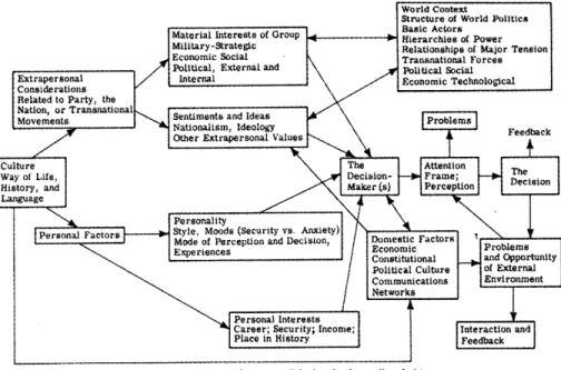
A Systems Analysis Model in Urbanization and Change: An Experiment in Interdisciplinary Education
The role of the designer was a central question in "Urbanization and Change," an interdisciplinary studio offered through the Department of Landscape Architecture in 1968. This question was addressed in the studio on two levels. The students were active
participants in the design of the simulation itself, the defined the rules for interaction, developed the linear equations, and set the parameters for each area of specialization in the model, thus design was primarily a matter of giving form to a system of representation. On another level, students were asked to consider what the role of the designer would be in the final computerized iteration of the model as they coded points of control into each of the mechanisms of the model. These control points would limit the degrees of freedom inherent in the system. In this way, the students were scripting their own future roles as architects and planners who would find themselves eventually practicing in the world outside of the academy.
of Urbanization and Chan"
Image: A Systems Analisr Model of Urbani ation and Change (Cambridge: MIT Press, 1970)
Two years after the studio finished, the results were published as A Systems Analysis
Model of Urbanization and Change: An Experiment in Interdisclinary Education. This book was
compiled by Steinitz and Rogers, and published by the MIT press two years after the studio was complete (in 1970), as MIT Report No.20. The publication recounts week by week what activities the studio engaged in as they built a simulation of the potentials for urbanization and change in the landscape of the Charles River watershed. Game theory was employed to generate the analogue simulation model that the students could "play," the authors explain, "The procedures developed for the simulations themselves are analogous to the board,
pieces, and rules of Monopoly."4 1 The reference to a game of real-estate and banking is telling of the currents of interest underlying much of this work in simulation, but it can be taken here as simple a way to explain the combination of chance and design in the model itself, as well as the necessity for strategy when engaging the model. When the techniques used in the lab intersected with the culture of the studio, focus shifted from open-ended questions of writing program and improving graphic display, to questions with a more defined set of ends, addressing theory and method for problem solving in the regional landscape. The professors of the studio, Steinitz and Rogers, describe their thinking on this matter:
"It would probably take several years to write a computer program for this simulation. So we did a patchwork process, and dignified it with the name "man-machine interaction." [...] These were developed as a set of rubrics for which the students then played the roles of FORTRAN statements. Of course, FORTRAN is more predictable than students; students in the middle of doing something always ask embarrassing questions. While embarrassing, this is how the model developed."
An Experiment in Interdisciplinary Education, was an attempt to find a new way for
landscape architects, engineers, planners, and urban designers to communicate with one another. They write, "Schools of design have often had interdisciplinary faculties, but to date there has been no system of organization that could bring the various disciplines together into a functioning whole.'A2 What is revealed in this statement is the notion that the system itself takes precedence over any one designer. Yet, the authors amend this idea in their next statement when they write, "Interdisciplinary education evokes the idealistic image of synthesizing all available knowledge, techniques, and skills into one super machine which will solve all problems. However, this interaction often has quite opposite results, such as cross-sterilization rather than cross-fertilization of fields and confrontation rather than dialogue."43 With this said, they propose a method of working through experimentation, with the admission that the process must if effect, be messy. They write that, "The teachers and students developed a high tolerance for ambiguity in the course of the semester. There were times in which the system appeared to break down completely- for example, when
41 Steinitz and Rogers, An Experiment in Interdisciplinary Education, p.5
42 Steinitz and Rogers, An Experiment in Interdisciplinary Education, p.1