HAL Id: hal-02592962
https://hal.inrae.fr/hal-02592962
Submitted on 15 May 2020
HAL is a multi-disciplinary open access
archive for the deposit and dissemination of sci-entific research documents, whether they are pub-lished or not. The documents may come from teaching and research institutions in France or abroad, or from public or private research centers.
L’archive ouverte pluridisciplinaire HAL, est destinée au dépôt et à la diffusion de documents scientifiques de niveau recherche, publiés ou non, émanant des établissements d’enseignement et de recherche français ou étrangers, des laboratoires publics ou privés.
River Fish Intercalibration Group WFD Intercalibration
Phase 2 : Milestone 1 report. Report to the European
community,
Didier Pont, M. Beers, T. Buijse, Olivier Delaigue, T. Ferrera, N. Jepsen, V.
Kovac, M. Schabuss, P. Segurado, C. Schuetz, et al.
To cite this version:
Didier Pont, M. Beers, T. Buijse, Olivier Delaigue, T. Ferrera, et al.. River Fish Intercalibration Group WFD Intercalibration Phase 2 : Milestone 1 report. Report to the European community,. [Technical Report] irstea. 2009, pp.48. �hal-02592962�
EUROPEAN COMMISSION
DIRECTORATE GENERAL JRC JOINT RESEARCH CENTRE
Institute of Environment and Sustainability
River Fish Intercalibration Group
WFD Intercalibration Phase 2 : Milestone 1 report
September 2009
Pont D., M. Beers, T. Buijse, O. Delaigue, T. Ferrera, N. Jepsen, V.
Kovac, M. Schabuss, P. Segurado, C. Schuetz & T. Vehanen
CemOA
: archive
ouverte
d'Irstea
Contents
1: Organisation 3
1.1. Responsibilities and participation 1.2. Work plan, Timetables and deadlines
2: Methods to be intercalibrated (Regional group reports) 6
A. Nordic Group
B. Lowland-Midland Group C. Alpine-type Mountains Group D. Mediterranean South-Atlantic E. Danubian Group
3. Progress on Collection of IC dataset and Design the work for IC procedure 31 3.1. Collection of IC dataset
3.2: Progress on Reference conditions/benchmarking 3.2.1 Definition of Reference sites
3.2.2 Comparison between Reference sites using common metrics
3.2.3 Definition of an overall pressure index and common metrics responses
Annexe 1: Methodology used for the computation of the common metrics 43
CemOA
: archive
ouverte
d'Irstea
Water category/GIG/BQE/
horizontal activity: RIVER FISH IC GROUP
Information provided by: Pont D., M. Beers, T. Buijse, O. Delaigue, T. Ferrera,
N. Jepsen, V. Kovac, M. Schabuss, P. Segurado, C. Schuetz, T. Vehanen
1: Organisation
1.1. Responsibilities and participation
Please indicate how the work is organised, indicating the lead country/person.
In continuation of our pilote exercice during the first IC round, it has been also decided that for the pilot exercise it was not necessary to organise this work within the already existing Geographical Intercalibration Groups (GIG’s). However, it seemed relevant to make regional groups that were responsible for the exchange of data and the reporting of the results. The main difference being that the process is centrally guided and that all data are submitted to the central database to facilitate comparisons between the national methods and the common metrics.
In the same way, we decided to use both the options 2 (common metrics approach) and 3 (direct national classification comparison within regional groups). The option 2 is used at the European level, at least to ensure the comparability of reference condtions between countries and regions.
26 Participants / Member States are involved:
Austria, Belgium-Wallonia, Belgium-Flanders, Czech Republic, Denmark, England-Wales, Estonia, Finland, France, Germany, Greece, Hungary, Ireland, Latvia, Lithuania, Luxemburg, Netherland, Northern Ireland, Norway, Portugal, Romania, Scotland, Slovakia, Slovenia, Spain, Sweden
Organization of the work:
Since the beginning of 2009, the leader of the whole group is Didier Pont (Cemagref, France) with the help of Olivier Delaigue (Cemagref, France, Common Database Management). The five regional groups are coordinated by:
U
Nordic GroupU: Teppo Vehanen
U
Lowland-Midland GroupU: Tom Buijse and Cornelia Schuetz (and with Marco Beers)
U
Alpine-type Mountains GroupU: Mickael Schabuss
U
Mediterranean South-AtlanticU: Teresa Ferrera (with Pedro Segurado)
U
Danubian GroupU: Vladimir Kovac
Cemagref (France) is in charge of the development of the common metrics.
CemOA
: archive
ouverte
d'Irstea
Are there any difficulties with the participation of specific Member States? If yes, please specify
Some member state could not participate due to the lack of national funding.
In addition, a large number national methods for river assessment using fish are always in development (e.g. Spain, Portugal, Scotland and Northern Ireland,…) or in revision (e.g. France).
The large rivers (mainly large floodplain rivers) are not considered in this second round. The participants plan to deal with this river type in 2011 and after, in close coordination with the large river assessment group coordinated by F. Schöll.
For these different reasons, the River Fish IC process will continue at least in 2011.
1.2. Work plan, Timetables and deadlines
Annex 1 to this questionnaire contains the the GIG work plans as presentedat ECOSTAT in
Nordic FI IR SC N-IR SE NO - Specificities (Environment, pressures) - Fish as indicator ? - Data collection - National methods - Option 3
Common approach (ICM, Option 2)
Common database - Environm. variables - Pressure types - Fish data -- Common metrics -- National methods
-Ref. conditions between Countries / Reg. Groups - Common metrics computation
-High/Good & Good/Moderate boundaries comparisons - Associated uncertainties INTE RCALIB RA TION Discussion Agreements General meetings Alpine-type Mountains AT DE FR SL ES Lowland Midland NL DE DN BE-F BE-W LUX FR LT LV EST ENG-W Mediterranean South-Atlantic FR ES PT GR Danubian RO CZ SVK HU AT SV 1 2 3 3 Regional meetings CemOA : archive ouverte d'Irstea / Cemagref
GIG All river GIGs Last update: 2009-09-19
Quality element Fish
Overview of results achieved to date and issues to complete/improve:
In continuation of our pilot exercise during the first IC round, it has been also decided that for the pilot exercise it was not necessary to organise this work within the already existing Geographical Intercalibration Groups (GIG’s). However, it seemed relevant to make regional groups that were responsible for the exchange of data and the reporting of the results. The main difference being that the process is centrally guided and that all data are submitted to the central database to facilitate comparisons between the national methods and the common metrics.
In the same way, we decided to use both the options 2 (common metrics approach) and 3 (direct national classification comparison within regional groups). The option 2 is used at the European level, at least to ensure the comparability of reference conditions between countries and regions.
26 Participants / Member States are involved:
Austria, Belgium-Wallonia, Belgium-Flanders, Czech Republic, Denmark, England-Wales, Estonia, Finland, France, Germany, Greece, Hungary, Ireland, Latvia, LLithuania, Luxemburg, Netherlands, Northern Ireland, Norway, Portugal, Romania, Scotland, Slovakia, Slovenia, Spain, Sweden
A common database is organized at the European level including environmental description of sites, pressures descriptions and biological information (species abundance and individual fish length).
Reference sites are selected using both common criteria at the European scale (sites not or slightly locally impacted) and national criteria. Sensitivity of the different national methods and common metrics to human pressure intensity is examined.
Estimated timetable for the completion of the work:
January-April 2009: Data collection / Data checking. Common database May 2009: Preliminary analysis (common metrics and regional groups) May 27-28 2009: 6th IC Meeting. Ireland. First results and discussion.
Harmonisation of statistical methods Table of contents of the final report
June-August: Data analysis. Exchange between partners. Final results. September 2009: Report to ECOSTAT
October 2009: ECOSTAT Meeting. Recommendations.
October 2009: 7th Fish IC meeting. Results and discussion about H/G and G/M classes boundaries Beginning 2010: 8th Fish IC meeting. Slovakia. Discussion about H/G and G/M classes boundaries October 2010: Final report: methodology, results, boundaries between class 1/2/3
Questions, & environmental situations remaining open.
Future tasks 2010-2011: Large rivers,… Comments: -- CemOA : archive ouverte d'Irstea / Cemagref
2: Methods to be intercalibrated (Regional group reports)
Regional group reports have been sent by their respective regional coordinators (see list before)
A. Nordic Group
The Nordic Group involves Finland, Ireland, Northern-Ireland, Norway, Scotland, and Sweden. Co-ordinator country in the group is Finland.
The group has two national methods to compare: the Finnish (FiFi) and Swedish (VIX) fish indexes.
Methods to be intercalibrated
Overview of the Finnish Fish Index (FiFi)
The Finnish Fish Index (FiFi) is currently published in Finnish and submitted as a manuscript to an international journal (Vehanen et al.: Environmental assessment of boreal rivers using fish data – A contribution to the Water Framework Directive. Fisheries Management and
Ecology, submitted). The Finnish report can be downloaded from the web-pages of the
Finnish Fisheries Research Institute: HTUwww.rktl.fi/?view=publications&cat=41UTH . The report is
“Vehanen, T., Sutela, T. & Korhonen, H. 2006. Kalayhteisöt jokien ekologisen tilan seurannassa ja arvioinnissa. Alustavan luokittelujärjestelmän perusteet. Kala- ja riistaraportteja nro 398.”
FIFI index is a multimetric index based on the reference conditions approach. Fish data is collected from wadeable rapids and stream areas that are electrofished according to the electrofishing CEN-standard (Water quality – Sampling of fish with electricity, EN 14011). Currently only the results of the catch of the first run is used by the index
Altogether 13 fish-based candidate metrics from biological elements (fish abundance, species composition and age structure) defined by the WFD were tested. First we used the
discriminant function analysis (DCA) to classify the reference (unimpacted) sites and impacted sites into their original groups. The proportion of observations that were not
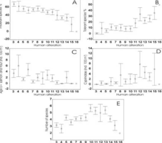
reassigned to their original group (an apparent error rate, APER) was used as a measure of the effectiveness of the metrics to distinguish between the impacted and unimpacted sites. Those candidate metrics with a small APER were selected for further analysis. They were correlated (Pearson) against the magnitude of human alteration to reveal the shape of response and that they showed a consistent trend throughout the scale of alterations (Fig. 1). Finally correlations between the selected metrics were examined, and if high correlations existed, one was
removed to avoid including several metrics reflecting the same pressure.
According to the results five metrics were selected for the fish index: number of fish species, proportion of intolerant species, proportion of tolerant species, density of cyprinid individuals, and density of age-0+ salmonids individuals.
Cumulative frequency distributions (CFD) were used to characterise the distribution of candidate metrics (Fig. 2). The value of the metrics for each finding was calculated by
dividing the total number of findings that were smaller than the finding by the total number of
CemOA
: archive
ouverte
d'Irstea
classical probability to have a smaller finding than the current one. The CFD was forced to start from zero, and it reached value one either at the maximum (density of 0+ salmonids and Cyprinidae family and number of species) or at the 95th percentile (proportion of tolerant and intolerant species). For metrics that increased with human disturbance (proportion of tolerant species, density of Cyprinidae group) the CFD scale was reversed (1-value) (Fig. 2). The number of fish species was an exceptional variable because the response to disturbance was hump-shaped: the species number increased with the disturbance effect, but declined again in the heavily impacted sites. Therefore it is necessary to calculate different values for these highly impacted sites (human alteration >11, Fig. 2). We used subjective valuation for highly disturbed sites following the shape of response (Fig. 1). For sites with less human alteration (< 11) we used a point estimate for classical probability (Fig. 2).
The fish index value was calculated as a mean from the five-point estimated metrics values for each site. The median index value for the reference sites of each river type was used as reference. The index values were calculated to ecological quality ratios (EQR) by dividing the index value for each site by type specific reference value. By the definitions of the WFD, ecological status classes must be set at high, good, moderate, poor and bad. The boundary between a high and good ecological status was set at the 25th percentile of the reference site EQRs. This was done because there is also natural variation in the reference areas and a sampling error of –25% as estimated to be outside the high status. The boundaries for other ecological status classes were set in equal intervals towards 0, the theoretical minimum.
Figure 1. Responses of the selected metrics to human pressure.
Figure 2. Cumulative frequency distributions for the five metrics selected for the fish index and calculated from the electrofishing data of the reference river sites and used to determine the value (between 0–1) for each fish metrics.
CemOA
: archive
ouverte
d'Irstea
Overview of the Swedish method (VIX)
An index for classification of ecological status based on fish data from running waters was developed in Sweden in 2006. The report “Environmental quality criteria to determine the status of fish in running waters - development and application of VIX” (Beier et al. 2007) is
published at HTUwww.vattenportalen.seUTH and HTUwww.fiskeriverket.seUTH (see “Service / Publikationer /
Finfo”).
To apply VIX (VattendragsIndeX = running water index) standardised data from electric fishing are needed. Fish data is collected from wadeable rapids and stream areas that are electrofished according to the electrofishing CEN-standard (Water quality – Sampling of fish with electricity, EN 14011). In Sweden, the period of sampling is restricted to July-October to be able to catch YOY fish and to avoid periods with flooding, and only native species have been considered when calculating the index.
Abundances are based on estimations from one or more runs of electric fishing, i.e. all electrofishing runs are included to calculate the metrics. Environmental variables needed are 1) size class of catchment upstream of the sampling site, 2) class of proportion of lake area in the catchment, 3) least distance to the closest lake upstream or downstream the sampling site (up to 10 km), 4) altitude above sea level, 5) slope, 6) yearly average air temperature, 7) average air temperature during July, 8) wetted width of the stream and 9) sampled area. Additionally, migration type of the trout (resident, lake migrating or sea migrating) is used to adjust the index accordingly.
The main principles and statistical procedures for developing the EFI (European Fish Index) were applied for developing VIX. Reference sites were identified using maximum values (1 or 2 out of 5) of four impact categories (toxic or acidification impact, nutrient or organic input, morphological as well as hydromorphological impact). Theoretical expected values for each metric are calculated using multivariate regression incorporating relevant environmental variables (transformed values). The residuals between expected values and observed values are transformed in two steps. First, the residuals are transformed to Z-values by dividing the residual with the standard deviation of the residuals for each metric. The Z-values are
transformed to P-values, which are probabilities for the observed value to represent impacted conditions, adjusted for the direction of the expected change in the metric with increased impact (the lower the P-value, the higher probability that the site is impacted). The index consists of the mean of these P-values.
The main focus was to find the clearest possible separation between “impacted” and mainly “unimpacted” sites, i.e. the “GM” border between good and moderate status (class 2 and 3 out of 5) according to the Water Framework Directive. According to the methods used developing the EFI, the border between good and moderate status was chosen where the probabilities of making type-I and type-II errors were equal, i.e. where the risks of classifying an impacted site (preclassified impact 3-5) as unimpacted (preclassified impact 1-2), or vice versa, were equal. The border between high and good status (“HG”) was chosen so that the probability of classifying an unimpacted site (preclassified impact 1-2) as impacted (preclassified impact 3-5) was less than 5%. The border between poor and bad (”PB”) was chosen so that the
probability of classifying an impacted site (preclassified impact 3-5) as unimpacted
(preclassified impact 1-2) was less than 10%. The border between moderate and poor was set in the middle between the GM and PB borders. The borders for status classes, set according to the Swedish dataset used for developing VIX, of the index values are: class 1 (high) ≥0.749,
CemOA
: archive
ouverte
d'Irstea
class 2 (good) ≥0.467, class 3 (moderate) ≥0.274, class 4 (poor) ≥0.081, and class 5 (bad) <0.081.
Potential metrics during the index development were the metrics from the existing Swedish index for fish in streams (FIX), metrics from another index especially developed for salmonid coastal streams (HÖL) and metrics from the European Fish Index (EFI). Six metrics out of 24 potential metrics remain in the final index (VIX) which distinguishes the degree of general human impact. The VIX metrics are 1) abundance of salmon and trout, 2) proportion of salmonid species reproducing, 3) proportion of tolerant species, 4) proportion of intolerant species, 5) proportion of lithophilic individuals and 6) proportion of tolerant individuals. The metrics 3-5 are also used in the EFI, but then only incorporating data from the first run of electric fishing.
VIX could classify 66% of the Swedish sites correctly, in the dataset used for the index development, when comparing with preclassified impact. When applying the index on an independent dataset containing preclassified impact, 73% of the sites were correctly classified as either belonging to the preclassified impact groups ‘unimpacted’ (class 1-2) or ‘impacted’ (class 3-5). In the Swedish electric fishing data (August 2006), 50% of the sampling sites were classified to good status, and 23% to moderate status, i.e. the majority of sites were in the crucial interval of good and moderate status. There was a significant positive relationship between EFI and VIX. However, EFI estimated the status class higher compared to VIX approximately eight times more often than the reverse case. Especially small streams with sea migrating trout were estimated comparatively higher with EFI than with VIX.
Checking of compliance of national assessment methods with the WFD requirements
Compliance of the Finnish Fish Index (FiFi) to WFD
The monitoring method for the parameters of the FiFi-index conforms to the international standards (CEN-standard, Water quality – Sampling of fish with electricity, EN 14011). In compliance with the WFD the FiFi index is a type specific approach. Within the ecoregion (Fenno-Scandian shield) the national typology is used. This typology is based on geology and size of catchments and includes 11 river types. In addition, northern rivers above the tree limit (partly Borealic Uplands) are separated. Type-specific biological fish-based reference
conditions are established from the reference sites. Within the index the five variables
represent the values of the quality elements for the classification of ecological status of rivers specified in Annex V of the WFD: composition (proportion of tolerant and intolerant fish species), abundance (density of Cyprinid-group, number of fish species) and age structure (density of age 0+-salmonids) of fish fauna.
Hydromorphological elements, chemical and physico-chemical elements and specific
pollutants are taken into account when selecting the reference sites. Only sites with no or low amount of pressures can be selected for reference sites. This is done in accordance with the common metrics – intercalibration and guidance (Guidance on the Intercalibration process- Phase 2, Annex II: Guidance for deriving reference conditions). The impact of human
pressures on metrics used to build the index was revealed during the development of the index (see the description of index above).
The results are calculated and expressed as ecological quality ratios for the classification of ecological status. The ratio is expressed as a numerical value between zero and one, with high
CemOA
: archive
ouverte
d'Irstea
ecological status represented by values close to one and bad ecological status by values close to zero.
Definitions for ecological status in rivers for the fish fauna as biological element follow the definitions of the WFD: high, good moderate, poor and bad. High status is defined by the reference data so that 25% of the reference sites (lowest quartile of the index values) remain outside of high status. Rest of the status classes are set in equal intervals towards zero. This is in accordance with the guidance, and also with the normative definitions. Normative
definitions state that that in high status species composition and abundance correspond totally or nearly totally to undisturbed conditions, and in high status there are slight changes in species composition and abundance from the type-specific communities.
Compliance of the Swedish Index (VIX) to WFD
The monitoring method for the parameters of the VIX-index conforms to the international standards (CEN-standard, Water quality – Sampling of fish with electricity, EN 14011). The VIX index is a site based approach. The reference values are calculated unique for each site by using the whole group of selected reference sites, i.e. including both impacted and unimpacted sites. Class boundaries are set originally based on the Swedish dataset used for developing VIX, with the main focus on the border between good and moderate status. Within the index the six metrics represent the values of the quality elements for the
classification of ecological status of rivers specified in Annex V of the WFD: composition (proportion of tolerant and intolerant fish species, proportion of tolerant individuals, proportion of lithophilic individuals), abundance (number of fish species, abundance of salmonids) and age structure (proportion of salmonids reproducing) of fish fauna. Similar principles and statistical procedures for developing the European Fish Index EFI (FAME consortium 2004, Pont et al. 2006) were applied for developing VIX. Reference sites were identified using maximum values (class 1 or 2 out of 5) of four impact categories
(preclassified toxic or acidification impact, nutrient or organic input, morphological as well as hydromorphological impact). This is done in accordance with the common metrics –
intercalibration and guidance (Guidance on the Intercalibration process- Phase 2, Annex II: Guidance for deriving reference conditions). The impact of human pressures on metrics used to build the index was revealed during the development of the index (see the description of index above).
The results are calculated and expressed as ecological quality ratios for the classification of ecological status. The ratio is expressed as a numerical value between zero and one, with high ecological status represented by values close to one and bad ecological status by values close to zero.
Definitions for ecological status in rivers for the fish fauna as biological element follow the definitions of the WFD: high, good moderate, poor and bad. The border between good and moderate status is set first, the clearest separation between impacted and unimpacted sites is 0,467. High status is defined by the reference data as the proportion of classifying an
unimpacted site as impacted is less than 5% (0,749). Rest of the status classes are set in intervals towards zero. This is in accordance with the guidance, and also with the normative definitions. Normative definitions state that that in high status species composition and abundance correspond totally or nearly totally to undisturbed conditions, and in high status
CemOA
: archive
ouverte
d'Irstea
there are slight changes in species composition and abundance from the type-specific communities.
Progress on feasibility checking: method acceptance criteria
The Nordic Group tested different river typology options using altitude (4 classes), geology (3 classes) and catchment size (5 classes) as variables. The general result was that typology (in all cases) improved the comparison of the results between the two methods compared. Reference conditions in different river types may differ and comparing similar river types improved their comparability. Currently the simple typology including geology and altitude (nine river types) is used by the group.
In terms of typology the two classification methods, FiFi and VIX, differ in nature. While the FiFi- index is a strict type based method using reference conditions for each river type
separately, VIX calculates the reference conditions by using the whole group of reference sites, i.e. including all types, as a reference. Therefore the typology is used in the Nordic Group comparisons only by removing sites from those types that are overrepresented in reference group in VIX calculations. Direct comparisons between types cannot be made, and therefore the use of typology is partly unfeasible.
If the methods shall be used in other countries, some adjustments are probably needed. For VIX it is important to investigate whether or not the reference values agree for the conditions in these countries. These calculations can be done. However, the critical point in the system is how to decide impact on a five degree scale. The classification system today is partly based on experiences and expert judgement. A revision of the classification system can probably improve both indexes even though they seem to work quite good already.
Still, there is a problem to apply the indexes. The indexes are built to use on a group of sites, not to study one site at one test-fishing occasion. When applying the index on one site, about three times out of ten the classification is incorrect. If the risk of misclassification is 30% for one sample, in the ideal case it declines to 0,027 after three samples (0,3^3). Therefore, to get a correct classification of a site several test-fishing occasions are needed. This issue can probably be illustrated by using sites were we can assume that the impact have been the same during the measuring period. Maybe we can agree on a proper sample size to be sure that the index probably is correct.
In terms of pressures the Nordic Group has agreed on how much pressures from different aspects (e.g. impoundment, acidification) is allowed in the reference sites. In general either no or low pressure is allowed in reference sites. This criterion follows the decisions made among the common intercalibration criteria for undisturbed sites.
The main pressures in the area covered by the group are pressures on water quality and
morphology of rivers. Both indexes tend to respond to pressures similarly: there is a relatively high correlation (r = 0.713) between the indexes. This also holds when data from each
countries is analyzed separately (r = 0.679-0.808), the only exception being Norway (r = 0. 228). There is also a response to pressures by both indexes on data on Norway, but the lack of correlation is mainly due to the fact that all Norwegian sites obtain high index values from both methods, and no low scoring sites are included. In terms of pressure the intercalibration between the both methods is feasible.
The basic assessment concept is the same in the both approaches: index is composed of several metrics which are found effective in response to human pressures. As the index values
CemOA
: archive
ouverte
d'Irstea
(or probabilities in VIX) increase the conditions should change towards reference conditions while the low values are indication of large changes. The basic difference in the concept is the setting of boundaries between the ecological status classes. The FiFi index assumes that most of the reference sites (75%, the good-high boundary is set here) are in high status, but makes no assumption of the shape of the distribution of index values in different river types. Rest of the status class borders are set in equal intervals towards zero value. VIX-index, however, assumes normal distribution of probabilities, and the border between good and moderate status is set where the probabilities of making type-I and type-II errors are equal, i.e. where the risks of classifying an impacted site as unimpacted are equal. The border between high and good status (“HG”) is chosen so that the probability of classifying an unimpacted site as impacted is less than 5%.
Progress on collection of IC dataset and design the work for IC procedure
The collection of IC dataset has been completed. A data template together with instructions and description of the variables was sent to contact persons of the group in each country. Later, following a group meeting where the criteria for the reference sites was agreed, member countries was asked to revise the status of their reference sites.
Each country in the group has delivered fish data suitable for both indexes. The database of the group has 1651 sites, 159 from Finland, 493 from Ireland, 71 from Northern-Ireland, 152 from Scotland and 702 from Sweden. Out of 1651 sites, 264 reference sites are identified. Finland has classified 96, Ireland 31, Norway 21, Scotland 23 and Sweden 93 reference sites. Northern-Ireland has not distinguished reference sites from their fish data.
Progress on reference conditions/benchmarking
We used the Intercalibration method option 3 to compare the results of the FiFi and VIX – methods. First both national methods were applied to the dataset. Then we calculated normalised EQRs based on the national view. National values were then rescaled to a
maximum of 1 and minimum of 0. Then we calculated the median value for the standardized reference dataset for both indexes and transformed the values into EQR’s by dividing the standardized value by the median value. After this the median value of reference sites was 1 and the minimum value 0.
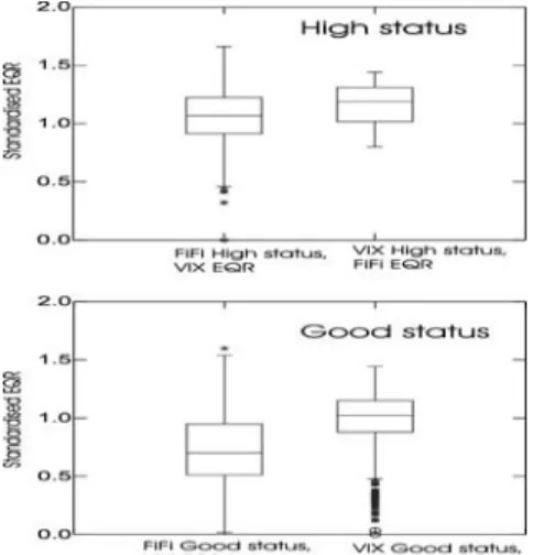
Figure 3. Box plot illustrating distribution of standardised EQR values for countries classified as being high status (above) or good status (below) in the FiFi and VIX indexes.
CemOA
: archive
ouverte
d'Irstea
To determine whether there is a significant effect of country on the distribution of EQR values we followed the intercalibration guidance. All sites that were classified as high status by the Finnish system (FiFi) were selected, and for those sites the standardised EQR values from the Swedish system we extracted, and vice versa. We then used ANOVA test the
possible differences. The difference between the countries was significant (p<0.001, Fig 3), as the EQR-values for both the VIX high status and good status sites were higher than in the FiFi system.
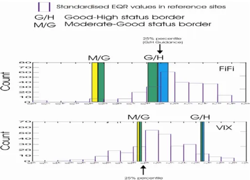
We plotted the distribution of standardised EQR values of the reference sites together with the boundaries for the high-good and good moderate sites (Fig. 4). FiFi index sets the boundary to the range of the 25% percentile of the EQR values of the reference sites (16-45%, variation is due to differences in river types). VIX-index is stricter and the high-good boundary leaves most of the reference sites (93%) outside the high status. The moderate-good status boundary in the FiFi system leaves only few reference sites to moderate status (2 %), whereas in VIX-system 21% of the reference sites achieve only moderate status.
Fig. 4. Standardised EQR values for Fifi and VIX – indexes and the boundaries for good-high and moderate- good status classes.
CemOA
: archive
ouverte
d'Irstea
B. Lowland-Midland Group
Overview of Member States providing national assessment methods
Do you have an overview of the national classification methods that will be intercalibrated? If not: when will this information be available?
Eleven partners from ten EU member states participate in the Lowland – Midland GIG, which is quite similar to the Central Baltic GIG. For Belgium, Flanders and Wallony participate separately. Sweden participates in the Northern GIG. Poland does not yet participate in the River Fish intercalibration. In total there are eight national methods with the following characteristics (for details see separate ZIP file)
Country Method Type of measurement Number of metrics Sp
e cie s pre sen c e S pec ie s a bunda nc y H abi tat gui ld T rophi c gu il d S e n sit iv it y g u il d R eprodu cti ve gui ld F is h re gi on ind e x M igra ti on in dex Ag e s tru ct u re
Belgium - Flanders Upstream IBI modelling; DFCRC 9 1 1 1 1 1 0 1 0
Belgium- Wallony IBIP DFCRC 6 1 1 1 0 1 1 0 0 1
Czech republic CZ national method 0-group only; DFCRC 9 1 1 1 0 0 1 0 0 0
England - Wales FCS
modelling; selected species;
DFCRC ? 1 1 0 0 0 0 0 0 0
France FBI
statistical method, deviation from
reference conditions 7 1 1 1 1 1 0 0 0 0
Germany FIBS DFCRC 6 or 9 1 1 1 1 0 1 1 1 1
Netherlands NL national method DFCRC 5 to 8 1 1 1 0 0 0 0 1 0
Lithuania LZI DFCRC ≤ 12 1 1 1 1 1 1 0 1 0
DFCRC
Denmark, Latvia and Luxembourg have no national methods; the method from Estonia is not known deviation from constructed reference community
Checking of compliance of national assessment methods with the WFD requirements
What are the arrangements in the GIG to verify the compliance of national assessment methods with the WFD requirements ? Has the GIG already started an evaluation of the compliance of national assessment methods with WFD requirements? Please give a short report on how this is done (or will be done)
In a first step all members of the GIG agreed on a common set of environmental variables to characterise the river types and a common set of pressures, which are provided in the regional and common database. All MS agreed on the same reference criteria (pressures) as follows: * All countries used the list of undisturbed sites in the common database which are also classified as reference sites by the concerned MS
* These sites have been checked for an appropriate fish community (> 30 individuals)
* All definite REFCOND sites of the Lowland – Midland groups will be used for EQR calculations
Common methods and boundary setting procedure are still in discussion within the Lowland Midland GIG CemOA : archive ouverte d'Irstea / Cemagref
Steps in review of the compliance of national assessments methods
with the WFD Done?
Completeness of the method according to the WFD normative definitions yes Establishing of biological dataset yes Relationship between pressure and biological metrics ?
Setting reference conditions yes Setting high/good and good/moderate boundaries no
Completeness of het national methods according to the WFD normative definitions Species composition Species abundance Age structure Belgium - Flanders √ √ Belgium- Wallony √ √ √
Czech republic √ partial (only YOY) England - Wales selected species selected species
France √ √
Germany √ √ √
Netherlands √ √
Lithuania √ √
Progress on Feasibility checking: method acceptance criteria
The intercalibration process ideally covers all national assessment methods within a Geographical Intercalibration Group. However, the comparison of dissimilar methods (“apples and oranges”) has to be avoided. Intercalibration exercise is focused on specific type / biological quality element / pressure combination. The intercalibration guidance foresees an “IC feasibility check” to narrow the actual intercalibration analysis to methods that address the same common type(s), the same anthropogenic pressure(s), and follow a similar assessment concept.
The task of the GIG is compilation of groups including similar assessment methods, and evaluation of “outlying” methods. A feasibility check includes coverage of intercalibration types, pressures and
method concept. The aim of the check is to address if all national methods address the same common
type(s) and pressure(s), and follow a similar assessment concept.
• Has the GIG evaluated if intercalibration is feasible in terms of typology? . Are the common type delineations suited for the specific BQE intercalibration exercise? Are all assessment methods appropriate for the intercalibration water body types ? Are any types going to be added?
•
Typology:
*The common intercalibration types for the Central-Baltic (CIT; see table below) have not been used to identify the type of river. This is because there is no agreement on this typology among MS. Instead every site is characterised by a set of environmental variables that are similar to those used for the CIT (except for alkalinity) as well as other variables. It is thus possible to link the CIT to these environmental variables, but this has not yet been done. All R-C1 to R-C6 are expected to be covered except for R-C5 (large rivers). The range over which the intercalibration is performed will be characterised by these environmental variables (see separate document for descriptive analysis)
CemOA
: archive
ouverte
d'Irstea
*Every MS has indicated whether or not their national method can be applied to sites in other countries. Sites are included or excluded on environmental characteristics, fish species composition or data availability (methods differ in their data requirements). The result varies per country ranging from e.g. the method of England & Wales which cannot be applied elsewhere to the national method of Lithuania that had no restrictions. So not every national method is applicable everywhere, but the sum of the methods cover the Central-Baltic region up to 400 m altitude.
• Has the GIG evaluated if intercalibration is feasible in terms of pressures?Do all
national methods address the same pressure(s) ?
Generally all methods have been developed in order to respond to single pressures or a combination of pressures, but there has been no approaches to develop one-to-one relationships between methods or metrics and single pressures. An in-depth analysis to which pressures national methods address has not yet been performed. The only metric that can be considered to have a direct link to a certain type of pressure is the migration guild that responds to disruptions in connectivity.
Within the River Fish intercalibration cross-GIG first the most important pressures that alter fish communities have been identified. Data on these pressures are available for every site. To deliver these data is compulsory. It is thus possible to demonstrate the response of national methods to various pressures or combinations of pressures.
As the national methods differ they may not address the same pressures. This cannot be indicated on beforehand, but may become clear during the intercalibration exercise.
See 2.1 for details on the national methods.
Type River characterisation
Catchment area (of stretch)
Altitude & geomorphology Alkalinity (meq/l)
R-C1 Small lowland
siliceous sand 10-100 km
2 lowland, dominated by sandy
substrate (small particle size), 3-8m width (bankfull size)
> 0,4
R-C2 Small lowland
siliceous- rock
10-100 km2 lowland, rock material
3-8m width (bankfull size)
< 0,4
R-C3 Small mid-altitude
siliceous
10-100 km2 mid-altitude, rock (granite) -
gravel substrate, 2-10m width (bankfull size)
< 0,4
R-C4 Medium lowland
mixed
100-1000 km2 lowland, sandy to gravel
substrate, 8-25m width (bankfull size)
> 0,4
R-C5* Large lowland mixed 1000-10000 km2 lowland, barbel zone*, variation
in velocity, max. altitude in catchment: 800m, >25m width
(bankfull size)
> 0,4
R-C6 Small, lowland,
calcareous
10-300 km2 lowland, gravel substrate
(limestone), width 3-10m (bankfull size) > 2 CemOA : archive ouverte d'Irstea / Cemagref
• Has the GIG evaluated if intercalibration is feasible in terms of assessment
concept? Do all national methods follow a similar assessment concept? If the GIG previously encountered problems with regard to checking comparability of dissimilar methods, how are these resolved ?
The national methods differ in their assessment concept. The pilot exercise with a selection of methods concluded that intercalibration may be feasible (Jepsen & Pont 2007). Since there are several methods and in addition there are also common metrics resulting from the projects FAME and EFI+ it is assumed that the intercalibration exercise will be able to identify which methods respond well or not to pressures and where boundaries require adjustment (see separate document with preliminary analysis according to option 3).
C. Alpine-type Mountains Group
Overview of Member States providing national assessment methods
Do you have an overview of the national classification methods that will be intercalibrated? If not: when will this information be available?
Overview of all three national classification methods within the Alpine GIG (for details see Annex I):
country Austria Germany France
method FIA FIBS FBI
type of measurement deviation from constructed reference community deviation from constructed reference community statistical method, deviation from reference conditions number of metrics 9 6 7 species presence + + + species abundance + + + habitat guilds + + + thropic guilds + + sensitiv guilds + reproductive guilds + + +
fish region index + + +
migration index + age structure + m et rics in clu d e
* Slovenia and Spain have no national methods until now
Checking of compliance of national assessment methods with the WFD
requirements
What are the arrangements in the GIG to verify the compliance of national assessment methods with the WFD requirements ? Has the GIG already started an evaluation of the
CemOA
: archive
ouverte
d'Irstea
compliance of national assessment methods with WFD requirements? Please give a short report on how this is done (or will be done)
steps in review of the compliance of national assessment methods with the WFD done
completeness of the method according to the WFD normative definitions yes
establishing of biological dataset yes
relationship between pressure and biological metrics yes
setting of reference condition yes
setting of high/good and good/moderate boundaries no
Completeness of the national methods of the WFD normative definitions
method species composition species abundance age structure
FIA + + +
FIBS + + +
FBI + +
In a first step all members of the GIG agreed on a common set of pressures and metrics which are provided in the national & common database. All MS agreed on the same reference criteria (pressures) as follows:
• All countries used the list of undisturbed sites in the common database which are also
classified as reference sites by the MS.
• Theses sites have been checked for an appropriate fish community (> 30 individuals,
single species sites are accepted)
• The impact of possible additional pressures (especially stocking/angling) on these sites
has been checked by the MS – impacted sites were excluded
• All definite Reference condition sites of the alpine group will be used for EQR
calculations
Common methods and boundary setting procedure are still in discussion within the GIG.
Progress on Feasibility checking: method acceptance criteria
The intercalibration process ideally covers all national assessment methods within a Geographical Intercalibration Group. However, the comparison of dissimilar methods (“apples and oranges”) has to be avoided. Intercalibration exercise is focused on specific type / biological quality element / pressure combination. The intercalibration guidance foresees an “IC feasibility check” to narrow the actual intercalibration analysis to methods that address the same common type(s), the same anthropogenic pressure(s), and follow a similar assessment concept.
The task of the GIG is compilation of groups including similar assessment methods, and evaluation of “outlying” methods. A feasibility check includes coverage of intercalibration types, pressures and
method concept. The aim of the check is to address if all national methods address the same common
type(s) and pressure(s), and follow a similar assessment concept.
• Has the GIG evaluated if intercalibration is feasible in terms of typology? . Are the common type delineations suited for the specific BQE intercalibration exercise?
CemOA
: archive
ouverte
d'Irstea
Are all assessment methods appropriate for the intercalibration water body types ? Are any types going to be added?
Fish-based river assessment with fibs and FIA is based on reconstructed reference fish communities taking into account a defined set of riverine species from Germany and Austria. Each reference fish community reflects unimpacted river conditions by taking into account river type as well as zoogeographical aspects and the longitudinal river zonation.
- Thus, fibs and FIA principally are applicable in any thinkable river type with a natural fish composition covered by the defined set of German and Austrian riverine species.
- Some limitations exist in river types of other countries housing species which do not belong to the defined set of German riverine species and which can not be replaced by an ecological equivalent of the set.
• Has the GIG evaluated if intercalibration is feasible in terms of pressures?Do all
national methods address the same pressure(s) ?
All methods (FIA, fiBS, FBI) address the same pressures (see chapter 2.2)
- fiBS and FIA- in accordance to the WFD - principally react on any pressure or
combination of pressures leading to significant alterations of species composition and/or species abundance and/or age structure, such as
- impairment of river habitats,
- impairment of river structure and river morphology - impairment of hydrology
- impairment of fish migration - impairment of substrate quality - impairment of water quality
• Has the GIG evaluated if intercalibration is feasible in terms of assessment
concept? Do all national methods follow a similar assessment concept? If the GIG previously encountered problems with regard to checking comparability of dissimilar methods, how are these resolved ?
FIA and fiBS follow a similar assessment concept (see chapter 2.1 and Annex I) FBI follows a dissimilar approach (model based approach, see chapter 2.1)
Although it is not possible to include the Danube fish community into the FBI, the reference fish communities for the alpine French rivers were classified according to the requirements of the FIA and fibs, providing comparability between the FBI and the FIA & fiBS.
CemOA
: archive
ouverte
d'Irstea
D. Mediterranean South-Atlantic
Comment on the current status of National Methods development
Among the MS that are included in the Mediterranean and South Atlantic Regional group, only one (France) has an official National River Bioassessment Method based on fish communities available for the current intercalibration phase. Therefore it was not possible to undertake any intercalibration exercise among National Bioassessment Methods of the MS included in this regional group.
Nevertheless, both Portugal and Spain are currently developing National Fish Indexes. However, since the methods are not yet completed and official, it is still not possible to provide a full description of the methods.
The Portuguese National Bioassessment Method based on river fish communities is on a final stage. It is a multimetric approach based on guild metrics. It is expected that until the end of 2009 a first version will be available to be tested at a national level and for intercalibration purposes. The Portuguese National Method is based on an official sampling method that follows the CEN Norm (EN14011, Water quality – Sampling of fish with electricity, 2003). The Spanish Fish Index is also being finalised. It consists of a predictive modelling approach based on species composition of fish communities. Nevertheless, it cannot yet be considered the Spanish official Index to be used on the bioassessment of the ecological status of rivers, since it is still on the validation stage. This stage will consist on the comparison of the results obtained with this index and those of other methods such as EFI+ and IBICAT. The Index will be official after its approval both by an expert committee and by Ministry officials.
Greece has no plan for the development of a National River Bioassessment Method based on fish communities for now.
France will employ the same bioassessment method used in the previous intercalibration exercise, the Fish-based Index (FBI). It is a method based on deviations from expected values under reference conditions, using a predictive modelling approach. It uses metrics based on individual indicator species. The method is described with further detail in the Lowland or
Alpine Regional Group sections of the present report. Even though the Index is currently
being revised, the new version will not be available before the end of the present intercalibration phase.
E. Danubian Group
The Danubian GIG consists of six member states: Austria, Bulgaria, Czech Republic,
Hungary, Romania and Slovakia. Austria and Czech Republic are also members of other GiG (Alpine and Midland/Lowland, respectively). All MS of the Danubian GIG have declared their interest to continue their participation at the IC process. On the other hand, the progress in the IC exercise achieved by now, and the intensity of participation may vary from country
CemOA
: archive
ouverte
d'Irstea
delivering data to the common database, but also in active collaboration in 2009. On the other hand, participation of Hungary became irregular over the last year, and the participation of Bulgaria has been rather passive by now. Nevertheless, we are hoping that both of the latter MS will fully participate at the subsequent IC process.
Methods to be intercalibrated
Overview of Member States providing national assessment methods
From among the six member states of the Danubian GIG (Austria, Bulgaria, Czech Republic, Hungary, Romania and Slovakia), only Austria, Czech Republic and Slovakia have developed their national methods. Romania will use the EFI+ method, Hungary and Bulgaria appear to be in the process of developing their national methods, though no details are available at the moment, and it is not clear when the methods are completed. The description of the Austrian method is provided within the Alpine GIG section, therefore, the following text focuses on methods of two member states: Czech Republic and Slovakia.
The Czech method
General principles
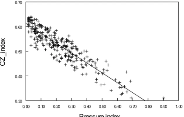
The Czech method (CZM) is based on the assessment of young-of-the-year (YOY) fish exclusively, using a multimetric Czech Index (CZI). YOY of European freshwater fishes occupy species-specific habitats reflecting their life-history requirements (Kryzhanovsky, 1949). Accordingly, YOY sampling has been proved as a tool that defines the availability of spawning/nursery habitats at a site (Oberdorff and Hughes 1991; Copp, 1992), as well as ecological function and integrity of riverine systems (e.g. Copp, 1989b; 1992; Oberdorff et al., 1993; Garner, 1995; Schiemer et al., 2003). YOY sampling provides a proper response to population dynamics, since year class strength is mainly affected by events that occur in the fishes’ early life (Balon, 1984). Thus, existence of a suitable spawning/nursery habitat and the availability of food could be of the utmost importance (Lightfoot and Jones, 1996, Garner, 1996). YOY are also easier to collect in large rivers than adult fish, and therefore are thought to better estimate the actual fish assemblage structure at specific sites (Cattanéo, 2005). Evaluation of the ecological status of streams based on fishes using CZM requires a proper typology of streams, reference communities for each stream type, and four metrics to calculate CZI (see below).
Sampling
The sampling procedure used in CZM is based on electrofishing. Partial sampling of the streams is sufficient, however, all types of habitats must be covered to obtain a representative sample of the site. Sampling area borders are determined with help of the portable GPS receiver. All sampling occasions should be undertaken during late summer, to assure
efficiency of YOY sampling (Copp, 1989a). Electrofishing of YOY is conducted by wading the bank in an upstream direction, regardless the river size (electroshocker maximum output 225 - 300 V, 6 A, pulsed D.C.). Although point abundance and continuous sampling of YOY are comparable in terms of qualitative analyses, continuous sampling is preferred in order to allow quantitative interpretation of results (Janáč and Jurajda, 2007). Most fish are identified to species and immediately released at the site of capture. Specimens that cannot be reliably identified are fixed in 4% formaldehyde solution for laboratory identification. YOY sampling represents a useful method for assessing the ecological quality of rivers with several
advantages compared to sampling the whole fish assemblages: 1) it provides a sensitive response to the habitat structure; 2) this response is relatively fast and reliable, regardless the longevity of adult fish assemblages or stocking; and 3) sampling efficiency in the longitudinal
CemOA
: archive
ouverte
d'Irstea
gradient is of negligible importance, since YOY gather in shallow areas near the shoreline (Schlosser, 1987) where they can be easily sampled regardless the river size.
Stream typology
The river typology of the Czech Republic was recently modified by the team of Jakub Langhammer and the following text, which contains his results, is presented with his kind permission. As a first step, appropriate variables that describe natural variability of rivers were preselected. These variables were a subject of statistical analyses, such as
Agglomerative hierarchical clustering (AHC), Pearson correlations, etc., performed on the base of GIS data covering the whole country. The analyses defined groups (clusters) of highly correlated indices. A variable with the highest explanatory power and/or relevancy to the variability of the biota was selected from each group. Thus, four final variables were chosen: sea drainage area, altitude, geology and stream order according to Strahler (1952). From among these, the sea drainage area was selected as a substitute of ecoregion. The ecoregion boundaries almost overlap with the sea drainage, however there are still some inaccuracies in their definition. Since the natural boundaries of sea drainage area better reflect the differences in species composition, natural boundaries are used rather than the artificial ones.
Based on the above approach, streams in the Czech Republic were divided into 23 main river types with further subdivision in the 55 river types on the fine-scale. This general typology was further modified with regard to the evaluation of fish assemblages. Subsequent cluster analyses divided the streams in Czech Republic into the following 5 main fish river types: 1) large rivers of the North Sea drainage area (Elbe River catchment) ; 2) large rivers of the Black Sea drainage area (Danube River catchment); 3) medium rivers of the Black Sea drainage area (Danube River catchment); 4) medium to large rivers of lower altitudes without sea drainage area specification; 5) brooks to medium rivers of predominantly higher altitudes without sea drainage area specification.
Geology was not found to have significant effect on the fish assemblage, and thus, geology was omitted as the variable for river typology according to fish. Altitude and stream order were found to be appropriate predictors of such variables as abundance or ecological guilds composition, and were used for further division of river types on the fine scale. Further subdivision of main river types resulted in the following 13 fish river types in the Czech Republic:
1 large rivers of the North Sea drainage area (Elbe River catchment) 2 large rivers of the Black Sea drainage area (Danube River catchment) 3 medium rivers of the Black Sea drainage area (Danube River catchment) Medium to large rivers of lower altitudes without sea drainage specification:
4 altitude less than 200 m and stream order from 4 to 6 5 altitude less than 200 m and stream order from 7 to 9 6 altitude from 200 to 500 m and stream order from 4 to 6 7 altitude from 200 to 500 m and stream order from 7 to 9
Brooks to medium rivers of predominantly higher altitudes without sea drainage specification:
8 altitude less than 200 m and stream order from 1 to 3 9 altitude from 200 to 500 m and stream order from 1 to 3 10 altitude from 500 to 800 m and stream order from 1 to 3 11 altitude from 500 to 800 m and stream order from 4 to 6 12 altitude greater than 800 m and stream order from 1 to 3 13 altitude greater than 800 m and stream order from 4 to 6
CemOA
: archive
ouverte
d'Irstea
In conclusion, the river typology of Czech Republic according to fish is based on three
variables: sea drainage area, altitude and stream order. Five main river types corresponding to typical assemblages are further divided by altitude and stream order resulting in the final 13 fish river types.
Czech multimetric index (CZI)
A typical fish assemblage was reconstructed for each of the 13 river types. For this purpose, a procedure based on the combination of present data, available historical data and expert judgment was used. Expected reference assemblages were subsequently expressed as values of various metrics that were preselected based on their ecological relevance and presumed ability to detect assemblage degradation. The preselected metrics were: presence of typical species, number of all species, overall abundance, presence of particular habitat and
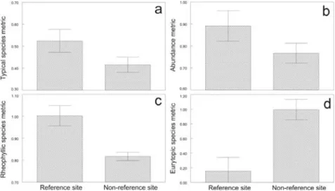
reproduction guilds, number of species belonging to particular habitat and reproduction guilds and relative abundance of particular habitat and reproduction guilds. In order to detect the deviations from the reference conditions, all the metrics were expressed as the ecological quality ratio (EQR) between observed and expected values. The final metrics selection was done according to their ability to distinguish between reference and disturbed sites from the national monitoring programme. This led to the selection of following metrics:
1. presence of typical species (F1, 235 = 5.31; P < 0. 0221; Tukey: P < 0.0221; Fig 1a ) 2. overall abundance (F1, 249 = 3. 99; P < 0. 0469; Tukey: P < 0.0469; Fig 1b)
3. relative abundance of rheophilous species (F1, 277 = 13. 71; P < 0. 0003; Tukey: P < 0.0003; Fig 1c)
4. relative abundance of eurytopic species (F1, 286 = 32. 26; P < 0. 0001; Tukey: P < 0.0001; Fig 1d).
Fig. 1: Typical species (a), abundance (b), rheophilous species (c) and eurytopic species (d) metrics values on reference and non-reference sites. Values are adjusted means ± S.E.
The Czech multimetric index consists of these selected metrics and is expressed as follows:
(TBSB + A + RBSB ) - (EBSB)
CZI = P
________________________________
P 4
where TBSB = EQR of presence of typical species, A = EQR of overall abundance, RBSB = EQR of
relative abundance of rheophilous species, and EBSB = EQR of relative abundance of eurytopic
species. CemOA : archive ouverte d'Irstea / Cemagref
Due to low natural abundance in the altitudes higher than 800 m, it is not possible to distinguish between such reference and non-reference sites using the overall abundance metric. Thus, for altitudes higher than 800 m the CZI is modified as follows:
(TBSB + RBSB ) - (EBSB)
CZI = P
______________________
3
The relative abundance of rheophilous species is considered a metric that increases ecological status of streams. However, chub Leucisus cephalus (L.) is a rheophilous species that is generally more resistant to several pressures than the other members of the rheophilous guild.
Thus, an assemblage dominated by chub could achieve a high value of RBSB despite the fact that
it does not necessarily reflect the good status of the stream. In order to handle this situation,
the value of RBS Bis considerd equal to zero when chub is the only rheophilous species in the
assemblage.
Class boundaries
Class boundaries within CZM were set with the help of the CZI values achieved on the reference sites according to the option C for setting class boundaries (Guidance document n. 10). The boundary between class 1 and 2 was set as the 1st quartile (25%) of distribution of reference sites. The remaining boundaries were set in equal distances according to it. The final class boundaries are:
HIGH GOOD MODERATE POOR BAD 0,78 0,585 0,39 0,195 CZI References
Balon E. K. (1984) Reflections on some decisive events in the early life of fishes. Transactions of the American Fisheries Society 113, 178–185.
Cattanéo F. (2005) Does hydrology constrain the structure of fish assemblages in French streams? Local scale analysis. Archiv fur Hydrobiology 164 (3), 345 – 365.
Copp G.H., (1989a) Electrofishing for fish larvae and 0+ juveniles: equipment modifications for increased efficiency with short fishes. Aquacult. Fish. Mgmt. 20, 453–462.
Copp G.H., (1989b) The habitat diversity and fish reproductive function of floodplain ecosystems. Environ. Biol. Fish. 26, 1–26
Copp G. H. (1992) An empirical model for predicting the microhabitat of 0+ juveniles in lowland streams. Oecologia 91, 338-345.
Garner P. (1995) Suitability indices for juveniles 0+ roach (Rutilus rutilus, L.) using point abundance sampling data. Regul. Rivers: Res. and Mgmt. 10, 99–104
Janáč M. Jurajda P. (2007) A comparison of Point Abundance and Continuous Sampling by Electrofishing for Age-0 Fish in a Channelized Lowland River. North American Journal of Fisheries Manegement 27, 1119 – 1125.
Kryzhanovsky S.G. (1949) Eco-morphological principles and patterns of development among minnows, loaches and catfishes. Part II: Ecological groups of fishes and patterns of their distribution. Akad Nauk SSSR, Tr Inst Morf Zhitovr im Akad AN Severtsova 1: 237 – 231 (Translation: Fish Res Bd Can Trans Series N° 2945, 1974)
CemOA
: archive
ouverte
d'Irstea
Lightfoot G.W. N.V. Jones (1996) The relationship between the size of 0-group roach, (Rutilus rutilus (L.)), their swimming capabilities, and their distribution in an English river. Folia Zool. 45, 355–360.
Oberdorff T. Hughes R. (1991) Modification of an Index of Biotic Integrity based on fish assemblages to characterize rivers of the Seine Basin, France. Hydrobiologia 228, 117 – 130.
Oberdorff T., Guilbert E. Luccheta J.C. (1993) Patterns of fish species richness in the Seine River basin, France. Hydrobiologia 259, 157 – 167.
Schiemer F., Keckeis H. & Kamler E. (2003) The early life history stages of riverine fish: ecophysiological and environmental bottlenecks. Comparative Biochemistry and Physiology Part A 133, 439–449.
Schlosser I.J. (1987) The role of predation in age- and size- related habitat use by stream fishes. Ecology 68, 654 – 659.
Strahler, A. N. (1952). Dynamic basis of geomorphology. Geological Society of America Bulletin 63, 923 - 938.
The Slovak method
General principles
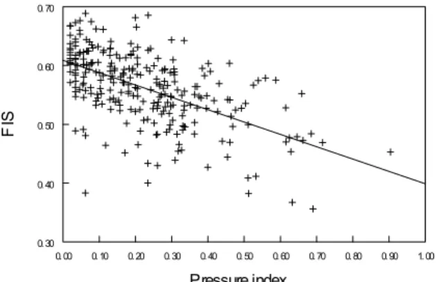
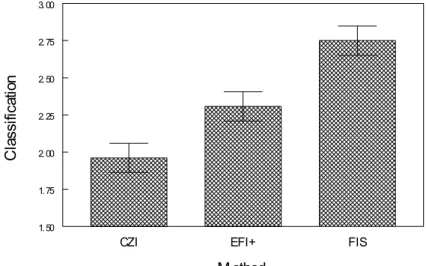
The Slovak method (SKM) is based on a multimetric index called Fish Index of Slovakia (FIS). SKM uses a new typology of Slovak streams designed especially with regard to fish communities (see below). For each stream type, a hypothetical reference fish community has been defined as a surrogate of large datasets necessary for valid statistical analyses. Such a reference community provides the expected values necessary for calculation of FIS that is based on the evaluation of observed vs. expected values. This evaluation is executed through nine metrics developed with regard to specific conditions in Slovakia. Most of the metrics follow the classification of fishes into ecological guilds. To facilitate calculation of FIS, a software tool FIScalc1.1. that works within the Microsoft Excel package has been developed. To reduce uncertainties in the evaluation of the ecological status of streams in Slovakia as much as possible, parallel to FIS, the European Fish Index plus (EFI+) will also be calculated, and the results from both methods will be assessed.
Sampling
The sampling procedure used in SKM is based on electrofishing. Whole sampling of the streams is preferred, though this is not always possible in medium and/or large rivers, where partial sampling is applied. In such a case, all types of habitats must be covered to obtain a representative sample of the site. In order to ensure collection of YOY specimens, and with regard to climatic conditions in Slovakia, the sampling campaign occurs between 16 July and 30 November, depending on the region, where the monitored stream is situated (local climatic conditions differ considerably in Slovakia). Most fish are identified to species and
immediately released at the site of capture. Specimens that cannot be reliably identified are fixed in 4% formaldehyde solution for laboratory identification. The details on the sampling protocol required by SKM have been described elsewhere (Hensel, 2002; Mužík, 2007). In general, this protocol is fully compliant with the sampling procedures required by the EFI+ process (http://efi-plus.boku.ac.at).
Stream typology
The typology of Slovak streams reflecting the fish communities has been developed based on two main criteria: the zoogeographical structure of fish fauna in Slovakia, and the zonation of streams. All details including justification of such approach have been described by Hensel (2001). This new typology used in SKM contains 23 stream types (Fig. 2).
CemOA
: archive
ouverte
d'Irstea