HAL Id: tel-01474077
https://tel.archives-ouvertes.fr/tel-01474077
Submitted on 22 Feb 2017HAL is a multi-disciplinary open access archive for the deposit and dissemination of sci-entific research documents, whether they are pub-lished or not. The documents may come from teaching and research institutions in France or
L’archive ouverte pluridisciplinaire HAL, est destinée au dépôt et à la diffusion de documents scientifiques de niveau recherche, publiés ou non, émanant des établissements d’enseignement et de recherche français ou étrangers, des laboratoires
smart city
Chen Wang
To cite this version:
Chen Wang. Location based services and location based behavior in a smart city. Other. Université de Lyon, 2016. English. �NNT : 2016LYSEC017�. �tel-01474077�
No d’ordre NNT : 2016LYSEC017
THESE de DOCTORAT DE L’UNIVERSITE DE LYON op´er´ee au sein de l’Ecole Centrale de Lyon
Ecole Doctorale INFOMATHSED No 512
Sp´ecialit´e: Informatique
Soutenue publiquement le 27/05/2016, par:
Chen WANG
Location Based Services and Location Based Behavior
in a Smart City
Devant le jury compos´e de :
Franck TARPIN-BERNARD Professeur - Universit´e de Grenoble Pr´esident Christophe KOLSKI Professeur - Universit´e de Valenciennes Rapporteur Ahmed SEFFAH Professeur - Lappeenranta University of Technology Rapporteur H´el`ene TATTEGRAIN Directrice - Laboratoire LESCOT Examinatrice Ren´e CHALON Maˆıtre de Conf´erences - Ecole Centrale de Lyon Examinateur
Chuantao YIN Associate Professor - Beihang University Co-directeur de th`ese Bertrand DAVID Professeur - Ecole Centrale de Lyon Directeur de th`ese
Acknowledgements
Firstly, I want to express my gratitude to Professor Bertrand DAVID, my super-visor of thesis. He is open minded, thoughtful, humorous. Doing research under his guidance gives me the feeling of “free to fly”. He is good at using heuristic methods, when giving comments and suggestions on my research work, so that he is not only an expert in Human-Computer-Interaction domain, but also adept in “Human-Human-Interaction”. He sent me to Web of Things summer school, Inter-net of Things exhibition, HCI international conference, etc., which expanded my knowledge and understanding of related topics of research. I am lucky and happy to be the last PhD student of Bertrand before his retirement.
Then I would like to thank Chuantao YIN, my co-supervisor, for his recom-mendation of me to Bertrand. During the application stage of the thesis proposal, I almost missed the deadline and it was Chuantao who helped me a lot in final-izing the discussion with Bertrand for the proposal of the thesis. He also shared with me his experience of doing research, and encouraged me with advices on the methodologies.
I also want to thank Ren´e CHALON, who works together with Bertrand in Ecole Centrale de Lyon, for reading and modifying our papers for conference or journal submission. He is serious and careful, and also helped me with user acceptability tests and analysis in my research work.
Support and help from colleagues and friends are something I also appreciate a lot. Ivan DAL PIO LUOGO, Ga¨el DUPERREY, Lo¨ıc MARTINEZ, Bertin NAYO, Thai-An GUYON have done their final internship of CNAM in the laboratory and since they have already several years of real working experience, I learned a lot from them through discussions about life and work as well as other cultural stuff (also got chance to practice my French). Other former members of the laboratory such as Tao XU, Yun ZHOU, Bingxue Zhang, Huiliang JIN, have also contributed to the
friendly and vivid ambiance of the lab.
Thanks to my family and my wife, Ying, who always support me during the hard times.
Thanks to China Scholarship Council (CSC) and Behihang University that pro-vide financial support and selected me to participate in the CSC-Centrale program for PhD study in France.
Contents
Acknowledgements i
Abstract xi
R´esum´e xiii
1 Introduction 1
1.1 Smart City and Ubiquitous Computing. . . 1
1.2 Location Based Services . . . 5
1.2.1 Historical View . . . 5
1.2.2 What Are LBS . . . 7
1.2.3 Classification of LBS . . . 8
1.3 Internet of Things . . . 10
1.3.1 What Is IoT . . . 10
1.3.2 The Emerging IoT . . . 11
1.3.3 Integrating Everything. . . 12
1.4 Research Area. . . 14
1.4.1 Research Question and Research Challenges . . . 15
1.4.2 Research Method and Research Contributions . . . 16
1.5 Organization of the Dissertation . . . 17
2 State of the Art 19 2.1 Analysis of a LBS – Friend Finder App . . . 19
2.1.1 Features and Usage . . . 19
2.1.2 Data Capture and Collection . . . 21
2.1.3 The LBS Platform and Middleware. . . 22
2.1.4 Our View . . . 25
2.2 IoT Architecture . . . 27
2.2.2 Middleware Consideration . . . 30
2.2.3 Other Work on IoT Infrastructure . . . 31
2.3 Transportation Issues and Traffic Simulation . . . 33
2.3.1 IoT in the Transportation and Logistics Area . . . 33
2.3.2 Traffic Simulation . . . 35
2.3.3 Dynamic Management of Road Lanes . . . 37
2.4 Summary . . . 40
3 ICT-based Dynamic Lane Management System 41 3.1 Our ICT-based Dynamic Road Lane Management System . . . 41
3.1.1 A System-Perspective Description . . . 41
3.1.2 Overview of the System . . . 43
3.1.3 System Architecture . . . 44
3.1.4 Location-Based Aspects . . . 46
3.1.5 User Interfaces . . . 47
3.2 The Simulation Environment . . . 47
3.3 Summary . . . 51
4 Core System Simulator and Technology Validation 53 4.1 Simulator Model Design . . . 53
4.1.1 A Two-Layer Model . . . 53
4.1.2 Simple Traffic Modeling . . . 54
4.1.3 Modeling of Priority and Dynamicity. . . 56
4.1.4 More Realistic Traffic Modeling . . . 61
4.1.4.1 Intelligent-Driver Model . . . 61
4.1.4.2 Lane-Changing Model . . . 64
4.1.5 Comparison and Optimization . . . 67
4.2 Simulator Implementation . . . 69
4.2.1 Data Flow. . . 69
4.2.2 Main Thread . . . 69
4.2.3 Other Key Threads. . . 71
Contents
4.2.3.2 Lane Thread . . . 73
4.2.3.3 Road Thread . . . 74
4.2.3.4 Clock Thread. . . 78
4.3 Technology Validation via a Mock-up. . . 79
4.3.1 Scenario Description . . . 79
4.3.2 Hardware Integration and API . . . 80
4.3.2.1 Hardware . . . 80
4.3.2.2 Component Management and Resource Representa-tion . . . 81
4.3.2.3 Server-Client Communication. . . 83
4.3.3 Scenario Execution . . . 86
4.4 Summary . . . 87
5 Visualization and HCI Analysis and Tests 89 5.1 Visualization Tool . . . 89 5.2 User Tests . . . 93 5.2.1 Motivation . . . 93 5.2.2 Experimentation Configuration . . . 94 5.2.3 Experimentation Protocol . . . 95 5.2.4 Analysis of Results . . . 96 5.3 Summary . . . 102
6 Conclusion and Future Work 103 6.1 Conclusion . . . 103
6.2 Future Perspectives. . . 105
Appendix A : Questionnaire 109
Appendix B : Raw Test Data 111
Publication 113
Bibliography 115
List of Tables
1.1 Categories and examples of LBS applications . . . 9
4.1 Parameters of IDM . . . 62
4.2 Parameter examples of IDM [Treiber 2010] . . . 63
4.3 MOBIL parameter examples [Treiber 2002] . . . 66
4.4 URI methods of component interfaces . . . 82
5.1 Synthesis of global results . . . 101
List of Figures
1.1 Examples of Smart City application area. . . 2
1.2 Relationship among different concepts in Smart City paradigm . . . 4
1.3 LBS applications1 . . . 6
1.4 Connecting everyday-life objects1 . . . 13
2.1 Kivera’s LBS platform ([Spiekermann 2004]). . . 23
2.2 Application Integration with/without middleware . . . 24
2.3 Context-aware middleware behavior workflow . . . 26
2.4 Proxemic interactive zones for ambient intelligence . . . 27
2.5 SOA and ROA for IoT middleware . . . 31
2.6 Web architecture of avatar agents([Mrissa et al. 2015]) . . . 33
2.7 Cooperative traffic view ([Gu´eriau et al. 2015]) . . . 35
2.8 Traffic modeling approaches: macroscopic vs microscopic. . . 36
2.9 Set of existing solutions . . . 39
3.1 Dynamic circulation lane allocation example . . . 42
3.2 More sophisticated situations are also possible. . . 42
3.3 Global view of the dynamic lane allocation environment . . . 43
3.4 System architecture diagram . . . 44
3.5 A whole section divided into several sub-sections . . . 46
3.6 Examples of in-vehicle interfaces . . . 48
3.7 Simplified notification interfaces for passive users . . . 48
3.8 Simulation environment functionalities . . . 49
3.9 Scenario editing tool of the simulation environment . . . 50
3.10 Traffic generator tool of the simulation environment . . . 50
4.1 The two-layer model of the simulator . . . 54
4.2 A task diagram among instances of auto, lane and clock . . . 55
4.4 A simulation launch diagram . . . 57
4.5 A simulation execution diagram. . . 58
4.6 A more complete configuration considering dynamicity . . . 59
4.7 Sequence diagrams considering dynamicity. . . 60
4.8 Vehicle ”a” considering lane change to the center lane . . . 65
4.9 A lane hopping observation diagram . . . 67
4.10 Global view of simulator data flow . . . 70
4.11 Mock-up overview . . . 79
4.12 Arduino card . . . 80
4.13 RFID reader and vehicle with RFID tag . . . 81
4.14 Collection of the components . . . 81
4.15 Led 01 resource representation . . . 83
4.16 Led 01 method representation . . . 84
4.17 Light method representation. . . 84
4.18 Example of an AJAX function for switching on a LED . . . 85
4.19 RFID event listener . . . 86
4.20 Scenario execution snapshots . . . 86
5.1 Command-line symbolic print as a form of visualization . . . 90
5.2 Graphical symbolic snapshot as a form of visualization . . . 91
5.3 Graphical symbolic animation as a form of visualization . . . 92
5.4 3D in-vehicle view . . . 92
5.5 An example of a static photo-based test . . . 94
5.6 Road signs evaluated . . . 95
5.7 Analysis of individual results for COMMENT . . . 97
5.8 Analysis of individual results for COMMAND . . . 99
Abstract
The concept of “Smart Cities” has emerged during the last few years to describe how investments in human and social capital and modern Information and Communica-tion Technologies (ICT) infrastructure and e-services fuel sustainable growth and quality of life, enabled by a wise management of natural resources and through par-ticipative government. To us, Smart City is a real augmented environment allowing ubiquitous computing, with up-to-date web 2.0, which is collaborative, mobile and contextual, human actors as well as different things (connected objects) are now an integral part of internet. In the international France-China project on Smart City we used the MOCOCO approach (Mobility, Contextualization, Collaboration) to conduct research work with multiple applications in working, learning and social situations; professional and home working situations, professional and teenager con-textual mobile learning situations as well as Smart City applications are taken into account – transportation, goods distribution and local sport and cultural activities. This dissertation focuses on Location Based Services, and Internet of Things, which are both important aspects of Smart City. The choice of dynamic manage-ment of road lanes as a case study in this thesis, is also a good practice of integrating new technologies to make the city smarter and to make our life more comfortable. According to Schiller and Voisard (2004), Location Based Services (LBS) can be defined as services that integrate a mobile device’s location or position with other information so as to provide added value to a user. During recent years, LBS has evolved from simple GIS applications and positioning of emergent phone callers to more complicated, proactive, application-oriented services adapted to different users. However, heterogeneity of devices, data management and analysis, and HCI aspects are always main challenges for LBS. Our goal is to make the LBS meet the requirements of Smart City, with use of Internet of Things (IoT), integrating a certain degree of ambient intelligence.
The theoretical aspect of our contributions is that we examine at component level the possibility and feasibility of using IoT to better support LBS. The ability of IoT architecture of integrating various objects gives LBS a better management of location-aware devices; the sensors can also enrich the data source of LBS. The middleware of IoT, good at objects abstraction and service composition, provides possibilities to deploy more intelligent and customized service components, thus can enhance the middleware of LBS.
The practical aspect of our contributions is that we choose a dynamic lane management problem as a use case study demonstrating our approach in regard to combining LBS with IoT for a Smart City application. The goal of the dynamic lane management system is to make a better use of road lanes by dynamic allocation of lanes to different types of transportation. We provide the system architecture, user interfaces and a simulation environment to validate the solution design. We also develop a proof of concept to validate the technological aspects of the lane management system.
The simulation environment of the lane management system is another impor-tant part of our contributions, it includes a core simulator to simulate the function of the system and the behaviors of the vehicles, and an editor of scenario and a gen-erator of traffic as initialization tools. Different visualization methods of simulation results are also taken into consideration. In addition, we develop an evaluation tool which allows for real time user interaction, based on the visualization of the results of the simulator to conduct user tests for HCI aspects, as human factors should always be considered in the context of Smart City.
The dissertation is organized as follows: Chapter 2 surveys related works and major references related to our topic of research; Chapter 3 describes the solution design to the dynamic lane management system and an overview of the simulation environment; Chapter4introduces the core simulator as well as the proof of concept; Chapter5shows different forms of visualization and presents our user tests based on an evaluation tool; Chapter6concludes the dissertation and shows our perspectives of future work.
R´
esum´
e
Le concept de ”Smart Cities” a ´emerg´e au cours des derni`eres ann´ees pour d´ecrire comment les investissements dans le capital humain et social, et dans les technolo-gies de la communication (TIC) infrastructures et services ´electroniques peuvent maintenir la croissance durable et la qualit´e de vie, par une gestion judicieuse des ressources naturelles et par un gouvernement participatif. Pour nous, Smart City est un environnement r´eel augment´e permettant l’informatique ubiquitaire, avec web 2.0, qui est collaborative, mobile et contextuelle, les acteurs humains, ainsi que des objets connect´es faisant d´esormais partie int´egrante de l’Internet. Dans le con-text de notre projet international France-Chine sur Smart City, nous avons utilis´e une approche MOCOCO (Mobilit´e, Contextualisation, Collaboration) `a mener des travaux de recherche avec de multiples applications dans des situations de travail professionnels et `a domicile, des situations d’apprentissage mobile contextuelles, ainsi que des applications de Smart City sont prises en compte - le transport, la distribution des marchandises, et des activit´es sportives et culturelles.
Cette th`ese se concentre sur les services bas´es sur la localisation (LBS), et In-ternet des Objets (IdO), qui sont deux aspects importants de Smart City. Le choix de la Gestion Dynamique des Voies de Circulation comme une ´etude de cas dans cette th`ese est ´egalement une bonne pratique d’int´egration de nouvelles technolo-gies pour rendre la ville plus intelligente et pour rendre notre vie plus confortable. Selon Schiller et Voisard (2004), les services bas´es sur la localisation peuvent ˆetre d´efinis comme des services qui int`egrent l’emplacement ou la position d’un dispositif mobile avec d’autres informations afin de fournir une valeur ajout´ee `a un utilisa-teur. L’objectif est d’utiliser la mise en œuvre IdO pour am´eliorer LBS, fournissant l’intelligence ambiante et d’assurer la facilit´e d’utilisation pour usagers dans des situations dynamiques.
la faisabilit´e de l’utilisation de l’IdO pour augmenter LBS. L’architecture de l’IdO a une capacit´e d’int´egrer divers objets, ce qui fournit `a LBS une meilleure gestion des dispositifs de g´eolocalisation; l’intergiciel de l’IdO, capable de faire l’abstraction des objets et la composition de services, donne la possibilit´e de d´eployer des composants de service plus intelligents et personnalis´es, ainsi peut am´eliorer l’intergiciel de LBS. L’aspect pratique de nos contributions est que nous avons choisi une probl´ematique de gestion dynamique des voies comme une ´etude de cas, validant notre approche d’utiliser l’IdO pour augmenter LBS dans une application de Smart City. L’objectif du syst`eme de gestion dynamique des voies est d’assurer une meilleure utilisation de voie de circulation par l’allocation dynamique de voies `a diff´erents types de transport. Nous avons fourni l’architecture du syst`eme du point de vue de TIC, et un environnement de simulation pour valider la conception de la solution. Nous avons ´egalement d´evelopp´e une preuve de concept pour valider les aspects technologiques du syst`eme.
L’environnement de simulation comprend un simulateur pour simuler la fonc-tion du syst`eme et les comportements des v´ehicules, un ´editeur de sc´enario, et un g´en´erateur de trafic en tant qu’outils d’initialisation. Diff´erentes formes de visu-alisation de r´esultats de simulation sont ´egalement prises en compte. En outre, nous avons d´evelopp´e un outil d’´evaluation bas´e sur la visualisation en 3D, qui per-met l’interation entre l’utilisateur et l’outil en temps r´eel, pour effectuer des tests d’utilisation comme l’´etude des aspects IHM, puisque les facteurs humains devraient toujours ˆetre mis en premiers dans le contexte de Smart City.
Cette th`ese est organis´ee comme le suivant: Chapitre 2 pr´esente l’´etat de l’art; Chapitre 3 d´ecrit la conception du syst`eme de gestion dynamique des voies ansi qu’un aper¸cu de l’environnement de simulation; Chapitre 4 pr´esente le simulateur et la maquette; Chapitre 5 montre de diff´erentes formes de visualisation et pr´esente nos tests utilisateurs; Chapitre 6 conclut la th`ese et donne nos perspectives des travaux futurs.
Mots cl´es: smart city, services bas´es sur localisation, internet des objets, simula-tion de trafic
Chapter 1
Introduction
1.1
Smart City and Ubiquitous Computing
The concept of “Smart Cities” has emerged in the last few years to describe how investments in human and social capital and modern Information and Commu-nication Technologies (ICT) infrastructure and e-services fuel sustainable growth and quality of life, enabled by wise management of natural resources and through participative government [David et al. 2012].
According to [Caragliu et al. 2011], a smart city can be defined along six dimen-sions: smart economy, smart mobility, smart environment, smart people, smart liv-ing and smart government. Each dimension includes some factors that can further describe the idea of them. For instance, smart mobility could comprise interna-tional or nainterna-tional accessibility, availability of ICT infrastructure, and sustainable, innovative and intelligent transportation systems. The smart city originates from the concept of “Smarter Planet” which was put forward by IBM in November 2008 ([IBM 2008]). They attempt to inject the new generation of information technolo-gies into the business, government and civil society of the city. They would also like to install sensors in objects in a complicated system (e.g. a grid network), to monitor its status and connect all the sensors together to the internet. Then, the central super computer or cloud computing resources could manage activities, living standard and production in a finer way.
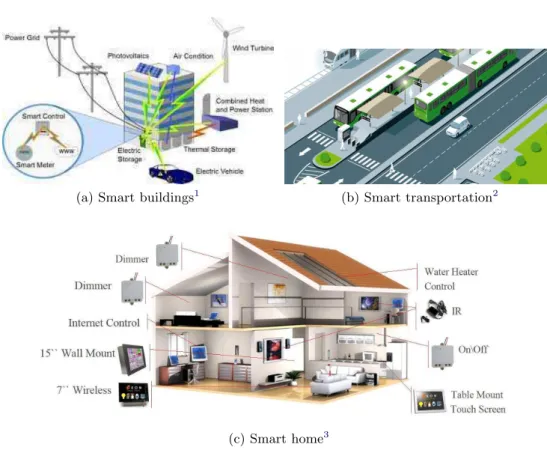
At present, the Smart City is still a concept undergoing evolution and exper-imentation. It aims at highlighting the role of ICT in a modern city, and at in-tegrating and optimizing the resources of a city, to make city life more efficient, energy-economic and intelligent ([Jin 2014]). Rather than focusing only on how
(a) Smart buildings1
(b) Smart transportation2
(c) Smart home3
Figure 1.1: Examples of Smart City application area
technologies can change the city, which is the case of “digital cities” or “intelli-gent cities”, the smart city also pays attention to non-technological aspects, such as social activity, environment, energy, etc.
David et al. described a smart city bus stop named “ABRI+Bus Shelter” ([David & Chalon 2010]) supported by Location-Based Services (LBS). This is a hotspot based system which uses a mobile network for communication between bus drivers and passengers to better serve passengers, especially those who have special needs (disabled people, people carrying bicycles, etc.). Moreover, the bus shel-ter contains an electronic display board to display local related information about shopping, cultural and sport events, which is the neighborhood life-oriented com-munication and cooperation hotspot. User needs and human participation cannot
1
Figure source: http://www.smartgridcontest.com/idea.php?id=145, last checked available on Feb 18th 2016
2
Figure source: http://newsroom.scania.com/en-group/2009/11/25/buses-the-base-in-sustainable-city-transports/, last checked available on Feb 18th 2016
3
Figure source: http://www.alibaba.com/product-free/107093675/Ekon_Smart_Home_phone /showimage.html, last checked available on Feb 18th 2016
Chapter 1. Introduction
be ignored, because the smart city is not only the application of new information technologies, but also concerns the participation of citizens in the various activities of the city with human intelligence.
Smart city large scale projects have been launched, in addition to academic re-search. The Smart City Lyon project([Metropole 2014]), launched by the Grand Lyon Bureau, encourages the development of innovative services for the next gener-ation of cities and is a test bed for promoting experiments. The blue print of Smart City Lyon includes:
• taking into account environmental challenges and energy constraints;
• promoting the networking approach of stakeholders with each other: local authorities, residents and businesses;
• allowing the switch from ownership to use: users’ involvement in the design of products and services;
• integrating new technologies (IT and communication, robotics, smart trans-portation systems, etc.).
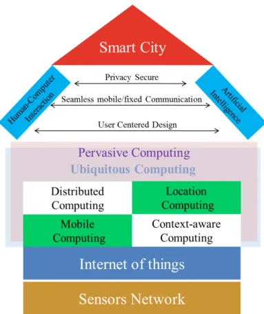
Though the smart city is gaining increasingly more attention, there are still no successful accurate models to follow. Researchers often have to imagine and design more interesting and promising scenarios of application. However, one of the challenges that the smart cities are facing, is how to bring innovative technolo-gies or concepts to the common appliances or daily life which citizens are already familiar with. This is because it takes time for the latter to accept such changes and user habits cannot be changed either easily or quickly. In this process, while technologies or concepts become less visible to users, users are gradually being immersed in an ubiquitous environment. According to the descriptions of Mark Weiser ([Weiser 1999]), The most profound technologies are those that disappear. They weave themselves into the fabric of everyday life until they are indistinguish-able from it. But the “disappearing devices” could be defined as all devices in an ubiquitous environment connected with each other seamlessly, so that users can fo-cus on the task they want to do, rather than fofo-cus on which devices they should use.
Figure 1.2: Relationship among different concepts in Smart City paradigm
In other words, ubiquitous computing is in fact a user-centric and context-aware in-teractive environment, based on seamless communication of various in-environment devices, to assist users in completing specific tasks more efficiently or to offer users more intelligent services.
Ubiquitous computing is also known as pervasive computing or ambient intel-ligence, which aims at building a context-aware interactive environment based on multi-devices and multi-sensors, although their focal points differ in some aspects. Ubiquitous computing tends to describe working environments like the collabora-tive environment designed by Mark Weiser, which integrated smart boards, pads and tabs to construct a distributed communication and collaborative system in the laboratory. Pervasive computing was first used and supported by IBM in 1998, with the main idea that computing could be conducted everywhere and anywhere by net-worked digital devices. Ambient intelligence first emerged in 1999 ([Ronzani 2009]), and is actually based upon the theories of ubiquitous/pervasive computing. It
Chapter 1. Introduction
combines research with Human-Computer Interaction (HCI), context-awareness (context-aware computing [Schilit & Theimer 1994]), etc., to create an environment that is sensitive and responsive to the presence of people. Figure1.2 describes the relationship among these different concepts in our view: we believe that Sensor Networks and the Internet of Things (IoT) are the basis. How to capture, organize, process and analyze the data generated from these connected sensors and devices is one of the major issues at stake. Z. Xiong ([Xiong 2012]) thinks that one of the smart city principles is based on the concept of “Data Vitalization”. The idea behind data vitalization is to let data have life, and to combine separate data for better usage.
1.2
Location Based Services
1.2.1 Historical View
The form of Location Based Services (LBS) is not new to us in the 21st century, since we either actively use them or passively receive location based push notifications in our daily life. To find a nearby restaurant using one’s smart phone, to choose an itinerary towards a parcel pick-up point, to receive welcome messages when traveling across different countries, to receive local weather forecast notifications: all these are just some of the examples of LBS that we are familiar with.
However, location services could date back to the 1970s, when the U.S. De-partment of Defense was operating the Global Positioning System (GPS), a space-based satellite navigation system serving the positioning of people and ob-jects. Consequently, GPS was initially intended for military purposes, and it was not until the 1980s that the U.S. government allowed positioning data to be freely accessed by other industries worldwide. Both [Bellavista et al. 2008] and [Schiller & Voisard 2004] believe that the mobile network played an important role in the emergence of LBS in the late 1990s. Actually, the U.S. government passed a mandate called Enhanced 911 (E911) in 1996, which asked mobile network operators to be able to locate emergency callers with prescribed accuracy, so that operators could deliver a caller’s location to Public Safety Answering Points. Cellular
Figure 1.3: LBS applications1
ogy could not fulfil these accuracy demands, so operators started making enormous efforts to introduce advanced positioning methods. To gain returns on the E911 in-vestments, operators launched a series of commercial LBS ([Bellavista et al. 2008]). These LBS offerings, in most cases, consisted of finder services that, on request, delivered to users a list of nearby points of interest, such as restaurants or gas stations.
In Europe, the European Union (EU) passed Article 26 of the “Directive of universal service and users’ rights relating to electronic communications networks and services (2002/22/EC of 7th March 2002)”, which asks member states to de-velop national regulations for mobile operators, enforcing the automatic positioning of emergency calls: “Member states shall ensure that undertakings which operator public telephone networks make a caller location information available to authorities handling emergencies, to the extent technically feasible, for all calls to the single European emergency call number 112.” Since more than 80% of European
op-1
Figure source:http://www.watblog.com/2008/04/16/mobile-positioning-and-location-based-services-an-insight-into-the-future-of-mobile/last checked available on June 19th, 2013
Chapter 1. Introduction
erators have implemented Cell-ID technology ([Concise-Insight-Ltd. 2003]), which could offer only a very low accuracy level, network operators tried to look for a com-mercial purpose for positioning information. This proved that even with Cell-ID, location information can successfully be integrated by operators into many exist-ing and new applications that enhance current value propositions and usability ([Schiller & Voisard 2004]).
In 2005, several significant developments and favorable conditions came together to make LBS re-emerge (Figure1.3). The emergence of GPS-aware mobile devices, the arrival of the Web 2.0 paradigm, and the introduction of 3G broadband telecom-munication technologies all contributed to enabling developments.
1.2.2 What Are LBS
The definition of LBS varies with different perspectives. Some regard LBS as “any service or application that extends spatial information processing, or Geographical Information Systems (GIS) capabilities, to end users via the Internet and/or wire-less network” ([Koeppel 2000]), while others view LBS as “geographically-oriented data and information services to users across mobile telecommunication networks” ([Batty et al. 2004]). Those are from the point of view of GIS, though the former puts forward the GIS abilities accessible in networked environments and the lat-ter concentrates on geographic data and information-providing services via mobile-networked environments. While traditional internet GIS applications, like online map services, were important LBS applications, current LBS are supported more and more by lightweight mobile devices such as smart phones, personal digital as-sistants (PDA) and wearable computing devices (smart watches, wristbands, etc.) that can deliver more personalized services. Also, we are reminded that location is one type of context, so that the LBS are also related to location-aware computing and context-aware computing.
Location Based Services can be defined as services that integrate a mobile device’s location or position with other information so as to provide added value to a user ([Schiller & Voisard 2004]).
So a true LBS application aims to provide personalised services to mobile users
whose locations are in exchange ([Jiang & Yao 2006]). According to [Karimi 2004], who uses the word “telegeoinformatics” to refer to LBS, there are some distinct characteristics of LBS that separate them from traditional GIS applications. Actu-ally, these characteristics are components such as models, software, hardware, data and people. Firstly, as we mentioned earlier, there have already been plenty of mo-bile devices that are location-aware, and each of them may have different hardware configurations and software platforms which also involve various telecommunica-tion technologies. Secondly, the source data of LBS can come from remote sensing, traffic and transportation surveillance, topographic maps, which would be managed dynamically and simultaneously. In consequence, integrating and processing of data in real time seems more challenging. Models for methodology generalization, ap-proach of data visualization and geo-processing in general would also call for further research challenges because the locations of users are changing all the time. Lastly, no LBS can ignore the end users who use the services: how to design the interfaces, how to visualize the results, how to adapt to different user needs, are all points that should be taken into consideration.
1.2.3 Classification of LBS
While researchers and analysts use different approaches to classify LBS applications, one main distinction could be “whether the service is person-oriented or device oriented”.
• Person-oriented LBS refer to applications in which a service is user-based. Therefore, positioning of a person or using the position of a person to fulfil a service is the focus of the application. Usually, the person located can control the service, e.g. a friend finder application ([Schiller & Voisard 2004]).
• Device-oriented LBS often put users in a relatively passive position, which means that the person or object for positioning usually does not control the service (e.g. “Find My Device” for lost phone tracking ). A device-oriented application may choose to locate a person, but is a free choice, not a necessary one. For instance, to locate a fleet where there is a group of people, the
Chapter 1. Introduction
Table 1.1: Categories and examples of LBS applications
application can choose to locate only one or two people aboard.
Another classification method, which is rather traditional, is to distinguish be-tween push and pull services.
• Push services mean that information is pushed to users without users having the intention to actively request it. This action should usually be performed with users’ prior consent or registered preference (e.g. Google Now cards for nearby point of interest recommendation), and users should always be able to modify their subscriptions. But there are times when we cannot reject the push messages, e.g. welcome messages upon entering a new country.
• Pull services, on the other hand, imply that users intentionally use an
tion and actively send requests to “pull” information down from the network. Pull services are the most typical form of LBS.
[Spiekermann 2004] gives an overview of the LBS service dimensions with some application examples, as shown in Table 1.1.
1.3
Internet of Things
1.3.1 What Is IoT
The Internet of things (IoT) allows static and dynamic environmental objects to communicate and update real situations. The basic idea behind the Internet of Things (IoT) concept is the pervasive presence around us of a variety of things or objects - such as Radio-Frequency IDentification (RFID) tags, sensors, actua-tors, mobile phones, etc., which, through unique addressing schemes, are able to interact with each other and cooperate with their neighbors to reach common goals ([Giusto et al. 2010]).
At first glance, the concept of IoT recalls the idea of Ambient Intelligence (AmI) and Ubiquitous Computing (UC). To recall their definitions, the former refers to electronic environments that are sensitive and responsive to the presence of peo-ple. In an AmI world, devices work together to support people in carrying out their everyday life activities, tasks and rituals in an easy and natural way using information and intelligence that is hidden in the network connecting these devices; when the devices are smaller and more integrated into our environment, only the user interface remains perceivable by users ([Ambient Intelligence Lab]). The UC focuses on the omnipresence of processing devices, which are small, inexpensive, robust, networked, and distributed at all scales ([Weiser & Brown 2014]). The con-cept of IoT is closely linked to AmI and UC, but its central issues are to make a full interoperability of interconnected devices possible, providing them with an ever higher degree of smartness by enabling their adaptation and autonomous behavior, while guaranteeing trust, privacy and security ([Atzori et al. 2010]).
Chapter 1. Introduction
and it is true that, among the research community, there have been vivid discus-sions about its manifold definitions. As is rather natural, if we decompose the IoT term, we obtain “Internet” and “Things”. The former would throw back a network-oriented view of IoT, while the latter moves towards objects that would be inte-grated into an existing framework. Some even push further to propose a concept of so-called “Web of Things” ([Guinard & Trifa 2009], [Duquennoy et al. 2009]), focusing on reuse of existing Web standards to integrate everyday-life ob-jects that contain an embedded device or computer ([Fielding & Taylor 2002], [Gellersen et al. 2009], [Kindberg et al. 2002], [Prehofer et al. 2007]). To bring Web-based smart things into peoples’ everyday life, and to enable humans to bet-ter inbet-teract with smart thing environments, more intuitive and explicit inbet-teraction mechanisms are required ([Mayer et al. 2014]).
1.3.2 The Emerging IoT
Although IoT has not been fully deployed, industrial, standardization and research bodies believe that it could have a huge impact on the behavior and social life of potential users. Possible application areas could be domestic and working fields such as domotics and healthcare, and could also include industrial manufacturing, intelligent transportation and business management. The US National Intelligence Council has placed the IoT in the list of six ”Disruptive Civil Technologies” that will have potential impacts on US national power ([National Intelligence Council 2008]). According to the NIC, ”by 2005, Internet nodes may reside in everyday things - food packages, furniture, paper documents, and more”, ”popular demand combined with technology advances could drive wide-spread diffusion of an internet of things that could, like the present Internet, contribute invaluably to economic development”.
As stated by the authors of ([Atzori et al. 2010]), advanced cars, trains, buses as well as bicycles along with roads and/or rails are becoming more instrumented with sensors, actuators, and processing power; roads themselves and transported goods are also equipped with tags and sensors that send important information to traffic control sites and transportation vehicles to better route traffic, and help manage depots. Several works have been published to describe IoT applications
in the transportation and logistics field. In ([Gerla et al. 2014]), the authors talk about the evolution from intelligent grid to autonomous cars and vehicular clouds as internet of vehicles. This will be a distributed transportation fabric capable to make its own decisions about driving customers to their destinations and will have communication, storage, intelligence, and learning capabilities to anticipate customers’ intentions. In the smart on-board transportation management system proposed by the authors of ([Tarapiah et al. 2014]), the implementation of the end-to-end system takes the form of a web application, taking advantage of RESTful architecture to meet functional requirements. A ”Barcelona city smart vehicle use case” has been designed to demonstrate the value of COMPOSE, an open-source Platform as a Service (PaaS) for developing Smart City solutions based on connected objects ([Doukas & Antonelli 2014]). In this use case, parking sensor information and traffic data from the streets of Barcelona city are processed by the API web services to provide output about the available parking places in the designated area, including traffic conditions and time of arrival estimation for each parking spot.
1.3.3 Integrating Everything
From a technologies’ point of view, to integrate “anything” into the Internet, the technologies of identification, sensing and communication are key elements (Fig-ure 1.4) ([Luckenbach et al. 2005]). One of the most widely used is the RFID sys-tems, consisting of readers and tags. The tags are attached to each object with its unique identifier and related information stored inside it. When receiving appro-priate signals from the reader, a tag nearby can respond to the query to announce its presence and transmit the information contained. Thus, RFID systems could be used to supervise the status of objects in real-time, where objects do not necessar-ily have to be within sight. Due to the cheap cost and low energy consumption of RFID systems, their use has been widespread in industry, especially in the trading network. Auto-ID Labs ([Auto-Id Labs ]), a leading global network of academic re-search laboratories in the field of networked RFIDs, has been making great efforts
1
Figure source:https://en.wikipedia.org/wiki/Internet_of_Things, last checked available on March 3rd, 2016
Chapter 1. Introduction
Figure 1.4: Connecting everyday-life objects1
towards standardization with its successor EPCglobal ([The EPCglobal ]).
Sensor networks are also crucial parts in the architecture of IoT ([Priyantha et al. 2008]). According to the author of ([Atzori et al. 2010]), sensor networks could cooperate with RFID systems to better track the status of objects, i.e., their location, temperature, movements, etc. Sensor networks are made up of a large number of nodes distributed in a certain way, which will report the sensing results to a small number of nodes (sink). A huge amount of research work has been carried out on sensor networks in recent decades, to tackle problems at all layers of the protocol stack ([Akyildiz et al. 2002]).
Besides ordinary objects, devices in which a certain degree of intelligence is embedded also need to be included in the network. Varying according to imple-mentation, communication technologies in smart devices could be Zigbee, Blue-tooth, low power WIFI and 6LoWPN ([Hui & Culler 2008a], [Hui & Culler 2008b], [IPSO alliance]), enabling their connections to the network.
With more and more devices and sensors linked to the network, we can imagine
the quantity of data that they would generate – a huge amount! However, this depends on the scale of the implemented IoT application: for example, there is no need to have a fully-fledged backend platform to store and process data when we just intend to implement a small smart home IoT application supported by less than ten sensors, whilst cloud-based software-as-a-service infrastructure would be necessary to enable millions of daily sensor readings for years of a large-scale IoT product. Furthermore, analytics should be conducted on the data to extract their value from raw bits and bytes, since big data analytics tools have become generally available, as well as basic statistical tools and more advanced machine learning approaches (deep learning): statistical tools finding you the known knowns in the data; machine learning finding the known unknowns; whilst deep learning is able to find the unknown unknowns ([College 2016]).
1.4
Research Area
This work is in the context of our international France-China research project on Smart City in the laboratory ([David & Chalon 2010], [David et al. 2011],
[David et al. 2012], [David et al. 2013]): Smart City is a real augmented environ-ment allowing ubiquitous computing, with up-to-date web 2.0, which is collabora-tive, mobile and contextual. Human actors as well as different things (i.e. LBS and IoT) are now an integral part of internet. We proposed an approach called MO-COCO (Mobility, Contextualization, Collaboration) to conduct research work with multiple applications in working, learning and social situations; professional and home working situations, professional and teenager contextual mobile learning sit-uations as well as Smart City applications are taken into account – transportation, goods distribution and local sporting and cultural activities.
This work focuses on LBS in Smart City. While previous work was conducted to study a physical hot spot based ([David & Chalon 2010]) communication / col-laboration style LBS, we still have a strong temptation to carry out further critical study on what LBS would be like in a Smart City, and provide new proposals for overall solution design using IoT and implementation for another case study
Chapter 1. Introduction
situation, especially in the transportation area.
One aspect that we have not yet talked about in regard to LBS, is privacy preservation, which is extremely important. Apparently, a location or locations the user has visited in the past are sensitive data and risk being misused – criminal intent or behavior analysis for commercial and advertisement purposes. [Bellavista et al. 2008] proposed dynamic trust management and user-controlled privacy policies to enforce privacy protection in the LBS. However, privacy issues are not concerned in the research area of this thesis and we shall not discuss them any further at present. The same goes for IoT.
1.4.1 Research Question and Research Challenges
The research question of this dissertation is how to adapt LBS to the requirements of Smart City, using IoT implementation to integrate a certain degree of ambi-ent intelligence in dynamic situations and assuring the reliability, extensibility and reusability of the applications. More specifically, we would like to build an environ-ment that allows location-based interaction, automatic location-based information propagation, and location-based behavior regulation, which are important aspects in our vision of user-centric LBS.
As we have already mentioned previously in the part on key characteristics of LBS, heterogeneity of devices, data management and analysis, and HCI aspects are classical main challenges for LBS.
The evolution of LBS also brings some new challenges, a short version of which could be, LBS become more complicated, involving a) from reactive to proactive, b) from self-referencing to cross-referencing, and c) from single-target to multi-target, d) from content-oriented to application-oriented ([Bellavista et al. 2008]). Reactive LBS are explicitly invoked by the user, while proactive LBS are auto-matically initiated when a predefined event occurs; user and target coincide in self-referencing LBS, while cross-referencing LBS make use of one target location for service-provisioning of another user; the major focus is on tracking one target’s position in single-target LBS, while in multi-target LBS, the focus is rather on in-terrelating the positions of several targets; content-oriented means relevant content
is delivered depending on users’ locations (a list of points of interest, maps, or infor-mation about nearby touring sites), but application-oriented LBS can dynamically deliver impromptu applications tailored to users to provide a more powerful and richer interaction model. Consequently, to design a solution for the LBS problem, much more would need to be taken into consideration.
1.4.2 Research Method and Research Contributions
The research method that we used in this dissertation belongs to the “Design Science Research” methodology category ([Kuechler & Vaishnavi 2008]), which means the design of novel or innovative artifacts and the analysis of the use and/or performance of such artifacts to improve and understand the behavior of aspects of Information Systems. It was mainly involved in the case study stage, as we built an artifact combined with use study as formal modeling of the artifact, in the solution design of an intelligent transportation system, which is also a type of information system. The main contribution of the work in this thesis is the proposition and validation of using IoT to enhance LBS in a Smart City. More specifically, the contributions are as follows:
• Examine at component level the possibility and feasibility of using IoT to better support LBS in the context of Smart City. This is carried out by conducting bibliographic studies on the three main concepts as well as primary significant achievements and projecting our thoughts onto them.
• Propose a solution design to a transportation problem – dynamic manage-ment of road lanes, including architecture, simulation environmanage-ment and user interfaces ([Wang et al. 2014a], [Wang et al. 2014b]). This is a case study of our approach with regard to combining LBS with IoT. What should be men-tioned here is that the simulation environment is critical: it not only serves as a tool to validate the overall solution design, but also provides a strategy to design the auxiliary tools when dealing with simulation-based projects.
Chapter 1. Introduction
the technological aspects of the dynamic lane management system, and to pro-vide an example of IoT enhancing LBS. Although the proof of concept is sim-ple, collection of data, integration of objects, transmission of information, and dynamic allocation are all involved and well supported ([Wang et al. 2015]).
• Conduct user tests using an evaluation tool based on visualization of the simulator results ([Wang et al. 2016]). This dynamic evaluation tool takes into consideration the speed of the vehicle as well as the surrounding circum-stances, and allows for real-time user interaction during the tests. This is an important step for the HCI aspects and is also valuable for visualization of data for both end users and developers.
1.5
Organization of the Dissertation
The remainder of this dissertation is structured into the following sections:
• In chapter 2, we survey related works and major references relevant to our topic of research. We also present our reviews and put forward our approach for combining IoT and LBS.
• In chapter3, we describe the ICT-based solution design to the dynamic lane management problem and we also give an overview of the simulation environ-ment.
• In chapter4, we introduce the central part of the simulation environment – simulator of core system, including a detailed discussion of model design. We then illustrate all the algorithms related to implementation of the simulator. The proof of concept as a technology validation is also introduced.
• In chapter 5, we first show different forms of visualization and then use a visualization tool to conduct user tests, and explain the analysis results.
• In chapter6, we conclude the work of the dissertation and provide our per-spectives with regard to future work in Smart City.
Chapter 2
State of the Art
In this chapter, we survey related works and primary significant achievements rel-evant to our topic of research. We begin with a LBS application analysis, then we present how the IoT architecture could enhance LBS, and we also talk about traffic simulation and issues of dynamic management of road lanes.
2.1
Analysis of a LBS – Friend Finder App
We first take a look at an example of LBS, which is a mobile friend finder applica-tion developed by AT&T Wireless ([Spiekermann 2004]). The goal was to provide enhanced LBS solutions for people to keep in touch with their family and friends, to be able to find one another, and to get directions to local shops and restaurants. At that time, Kivera just came out with a new location-aware GPRS (General Packet Radio Service) service called mMode (essentially a WAP (Wireless Application Pro-tocol) variant), so the two companies collaborated to create the first-ever Friend Finder application built upon Kivera’s Location Engine. In 2001, when most LBS were straight forward simple GIS applications, AT&T’s Friend Finder application was indeed a forward-thinking and visionary step in making the first wireless LBS application accessible to the general public.
2.1.1 Features and Usage
The friend finder application provides the following features:
• Deliver relevant user information about the location of a friend or family member’s mobile cell phone position.
• Calculate driving directions from a mobile cell phone position to an address or a point of interest
• Provide for selection of a business point of interest meeting place between two mobile cell phone positions.
• Provide for selection of a business point of interest in the proximity of a mobile phone position.
The user is offered a browser-like interface to access all the functionalities, the sequence could be as follows:
• First, a user, i.e. Tom, adds selected friends and family members to his friend list. This is done simply by typing the friend’s (i.e. Alice) AT&T cell phone number from an appropriate screen window.
• Alice, Tom’s friend, then receives a text notification on her mobile, asking whether Tom can add her to his friend finder list, which implies that later on Tom is authorized to track her location.
• If Alice replies affirmatively to Tom’s friend adding request, she is added to Tom’s friend list.
• Tom can now choose Alice from his friend list and select “find friend” in a pop-up menu to locate her. The location of Alice’s phone (street address or closest intersection) is transmitted to Tom’s phone. At the same time, Alice is also notified by a message that her newly added friend Tom has queried her location with this application. Alice can always choose to be invisible to Tom if she does not want to reveal her location to him, or feels like blocking this contact.
• Once Tom has received Alice’s location, he can get directions to her location and find restaurants and cinemas (or other points of interest) near her, or some place in between, so that they can meet.
Chapter 2. State of the Art
2.1.2 Data Capture and Collection
No LBS can live without a data source and nor can the friend finder application. Actually, it mainly uses information from the road network database, business and landmark information, and dynamic data such as traffic state and weather reports. The road network database usually contains digital formats of geographic con-tent and map data. These data can be captured in various ways, such as satellite remote sensing imagery, scanned maps, etc.. Some vendors even physically drive each road segment in GPS-equipped cars, registering every change of direction and photographing road signs to keep track of specific road conditions such as speed and height / weight restrictions. Map data are stored in a vector format made up of line segments, which represent the roads and link points representing intersections or other road features. Each link has start and end points as well as possible shape points for curved roads. Attributes are also added to data, such as forbidden turns, tunnels, bridges etc..
So these road network data support the friend finder application’s core LBS functionality: geo-coding, phone location display and driving directions. The lati-tude / longilati-tude coordinates of the user’s cell phone are resolved in the application to obtain the address. The coordinates may come either from the mobile operator who looks up the cell tower location, or directly from the embedded GPS chip in the cell phone, or even both.
The point of interest information forms another database, which links the busi-ness and landmark information to the road network database, so that the digital representation of the road network becomes more detailed and rich. Map data vendors can enrich their database by attaching point of interest information, while business vendors can also contribute their geo-coded piece of information to the LBS provider’s data set, i.e. retail stores integrating their digitized location to allow customers to search for the nearest stores.
So point of interest data together with map data can provide users with a selection of meeting places between two mobile phone positions. A user can of course select a business point of interest in his/her own proximity to his/her phone’s
location.
Last but not least, we have dynamic data. Users who travel daily from home to work by car are really interested in the optimal route during morning and evening peak hours. Traffic situations and weather conditions can largely affect a road’s supported traffic speed. However, these data cannot be coded into a map data set a priori. So, in most cases, LBS providers look for reliable dynamic data sources or use directly other dynamic data based services to carry out a service composition in their LBS platforms.
In the case of the friend finder application, it seems that dynamic data are not as important as others, since they are only useful when suggesting driving directions while a well designed navigating system can do a better job.
2.1.3 The LBS Platform and Middleware
Kivera’s LBS platform, on which the friend finder application is based, is shown in Figure 2.1. The map data set, point of interest database, geo-coding component, and routing software form the packages that the application developer can use to build custom LBS applications. Some LBS vendors choose to market LBS directly to consumers and to provide stand alone packages, such as store finders, to businesses. These applications are favored by companies that do not need highly customized solutions.
Actually, the Kivera’s LBS platform could already be considered a middleware – the part between “Location Infrastructure” and “Application Platform”. If we look at the relationship from Kivera’s point of view, the application layer is in fact the “client” group in the LBS industry, and the friend finder application is not the only member. Since position determination equipments are set deeply in the network operators, and the number of LBS applications is increasing, a middleware is im-plemented that comprises all of those services requesting location data to integrate it into the offering. Later on, if a new type of individual data service is added, it should not require complex and lengthy hookup. In other words, the middleware layer can significantly reduce the complexity of service and application integration (Figure 2.2). From the point of view of the developers of the friend finder
appli-Chapter 2. State of the Art
Figure 2.1: Kivera’s LBS platform ([Spiekermann 2004])
cation, if one day they find that Kivera’s LBS platform can no longer meet their needs as they plan to add more sophisticated features, they can set up their own LBS middleware to better support the application.
According to [Jacobsen 2004], a middleware is defined as a “set of services that facilitate the development and deployment of distributed applications in heteroge-neous environments”, and a middleware system should abstract the details of the underlying operating system, network substrate and protocols, mask possible fail-ures, and even mask the distribution of interacting systems; in the context of LBS, it refers to the services, abstractions, and models that implement mobile user coor-dination, information correlation, and information dissemination. More precisely, some of the requirements of LBS middleware ([Cugola et al. 2002], [Jacobsen 2001]) are as follows:
• Management of the mobility-awareness inherent to all LBS applications, to support disconnected operations.
Figure 2.2: Application Integration with / without middleware ([Spiekermann 2004])
• Management of changes in the underlying network topology that may occur, such as ad-hoc location-based services.
• Management of large numbers of data sources, information providers.
• Management of large amounts of content sent to the system for filtering, matching and correlating, propagation of information to thousands of con-sumers simultaneously.
• Management of variation of users’ interests (e.g. update, insertion, removal).
• Processing of various content formats such as attribute-value pairs (HTML), XML marked-up data, easy configuration for support of other evolving data formats.
• Support for different notification channels and protocols such as WAP, UDP, TCP, SMTP, SOAP, etc.
• Support for approximate subscriptions and approximate events to enhance system flexibility by increasing the expressiveness of the filtering language and the publication language.
Chapter 2. State of the Art
• Support for high availability despite node failures (e.g. guarantee notification delivery success rate).
2.1.4 Our View
The AT&T’s friend finder application as well as its functionalities are no longer cutting edge stuff in our days thanks to the rapid development of information and communication technologies. However, the reason why we cite it here, is that it is really a typical example which shows the limitations in the evolution of LBS, and thus provides us with reference for improvement to adapt to the requirements of Smart Cities. As we mentioned earlier, to integrate a certain degree of intelligence in LBS, and to provide more personalized or customized LBS, we have to make better use of data. Nevertheless, the road network data together with point of interest data have already been leveraged by developers for several years now. Consequently, we need to divert our attention to dynamic data (section2.1.2).
One possible direction is “Location as a Context ([da Rocha 2004])”. According to [Abowd et al. 1999], context is defined as “any information that can be used to characterize the situation of an entity. An entity is a person, place, or object that is considered relevant to the interaction between a user and an application, including the user and application themselves”. So location is exactly part of context, but context contains far more things than location. Context constitutes an important part of LBS, as both the user and location belong to context ([Jiang & Yao 2006]). In LBS applications, context modeling could capture physical environment elements (absolute or relative location, infrastructure, conditions, etc.) and human factors (user, task, social environment). Mobile computing middleware makes use of con-text information to support adaptability, such as providing proximity-based selec-tion (context-aware middleware for ambient intelligence [Xu 2013]), and to fire ac-tions when there is a context change (proxemic interaction with large public screen [Jin 2014]).
The work flow of the user-centric context-aware middleware in ambient intel-ligence proposed by [Xu 2013] is described in Figure 2.3: the application informs the versatile context interpreter which context model to use and asks to receive
contextual evolution (1&2); the enterprise service bus collects the data from dif-ferent sensors and propagates them to the context aggregator, before transferring the data to the context knowledge base (3&4); the query engine is then notified of arrived data and it also calls on the context inference engine to apply context infer-ence (5&6); after the inferinfer-ence operation, data are re-collected by the query engine (7&8), before being sent to the application (9); the application can also decide to update actuator states (10).
Figure 2.3: Context-aware middleware behavior workflow [Xu 2013]
As for the location-based proxemic interaction with a public display ([Jin 2014]), as shown in Figure 2.4, the space in front of a public display can be classified into several zones according to the user’s location, or the distance from the display. In Figure 2.4(a), there are two discrete areas, the information displayed and the in-teraction type could be different in each area; besides, users in closer areas cannot be disturbed by users in outer areas. In Figure 2.4(b), there is only one continu-ous interactive area. Although there are no border lines, the saturation of colors indicates the interaction types: from far to close, users can get increasingly more information and gradually engage in increasingly sophisticated interactions or take increasing control of the display screen.
Chapter 2. State of the Art
Figure 2.4: Proxemic interactive zones for ambient intelligence [Jin 2014]
there are no appropriate data providers. LBS, in this respect, can be seen as a kind of context-aware service, so that all the context-aware middleware can contribute to LBS design or LBS middleware deployment.
Another direction is counting on IoT. As a matter of fact, the devices that generate location data, or the infrastructure itself, could all be part of the IoT in a Smart City. So why not use the whole IoT implementation to enhance LBS, from data source to middleware, from service integration to data visualization. Another fact is that most of first-hand context information is captured via sensor technology ([Schmidt et al. 1999]), and sensor networks are crucial parts in IoT architecture (section1.3.3). Potentially, the IoT could also enhance context-aware computing.
2.2
IoT Architecture
Instead of going through all the details of IoT architecture, we here concentrate on some important elements that are related or helpful to LBS.
2.2.1 Device Integration – REST Architecture
It is easy to say that objects are connected via wireless communication technologies and then they are ready to serve our applications, but one of the problems that con-cern us is “how” – how to assure a consistent access to the connected objects and their functionalities. [Guinard 2011] proposed in his work a complete Web of Things (one vision of IoT that concentrates on reusing existing Web standards)
ture, in which a device accessibility layer is placed and REST (REpresentational State Transfer) architecture is used to solve the problem. The REST tries to support “scalability of component interactions, generality of interfaces, the independent de-ployment of components as well as intermediary components to reduce interaction latency, enforce security, and encapsulate legacy systems” ([Fielding 2000]).
The core idea of REST regards the notion of resource as “any component of an application that needs to be used or addressed” ([Guinard 2011]). Resources could be real physical objects, abstract concepts (collections of objects), as well as transient and dynamic concepts (server-side state of transactions). The principles of REST are as follows ([Fielding 2000]):
C1 Resource Identification: the Web relies on Uniform Resource Identifiers (URI) to identify resources, thus links to resources (C4) can be established using a well-known identification scheme.
C2 Uniform Interface: resources should be available through a uniform interface with well-defined interaction semantics, like the Hypertext Transfer Protocol (HTTP). HTTP has a very small set of methods with different semantics (safe, idempotent, and others), which allows interactions to be effectively optimized. It also allows for a clean decoupling of the interface (RESTful interface) and the actual service implementation. The uniform interface has 4 main methods: GET, PUT, DELETE and POST, with good coverage of CRUD (Create Read Update Delete) types of applications. So they are also supported to explicit every action a client can execute on a resource, whatever the type of application.
C3 Self-Describing Messages: agreed-upon resource representation formats make it much easier for a decentralized system of clients and servers to interact without the need for individual negotiations. On the Web, media type sup-port in HTTP and the Hypertext Markup Language (HTML) allow peers to cooperate without individual agreements. For machine-oriented services, me-dia types such as the Extensible Markup Language (XML) and JavaScript Object Notation (JSON) have gained widespread support across services and
Chapter 2. State of the Art
client platforms. JSON is a lightweight alternative to XML that is widely used in Web 2.0 applications and directly parsable to JavaScript objects.
C4 Hypermedia Driving Application State (Connectedness): clients of RESTful services are supposed to follow links they find in resources to interact with ser-vices. This allows clients to “explore” a service without the need for dedicated discovery formats, as well as allowing clients to use standardized identifiers (C1) and a well-defined media type discovery process (C3) for their exploration of services. This constraint must be backed by resource representations (C3) with well-defined ways in which they expose links that can be followed.
C5 Stateless Interactions: this requires requests from clients to be self-contained, in the sense that all information to serve the request must be part of the request. HTTP implements this constraint because it has no concept beyond the request / response interaction pattern; there is no concept of HTTP ses-sions or transactions. It seems important to point out that there might very well be states involved in an interaction, either in the form of state informa-tion embedded in the request (HTTP cookies), or in the form of a server-side state that is linked from within the request content (C3). Even though these two patterns introduce the state into the service, the interaction itself is com-pletely self-contained (in other words, does not depend on the context for interpretation) and thus is stateless.
Bearing in mind the REST architecture, we can integrate all the location-aware devices and objects that can provide useful data and services in the framework, by following the steps proposed by [Guinard 2011]:
1. Resource Design: identify the functionality or services of an object, organize the hierarchy of these services and link them together, fulfilling constraints C1 and C4.
2. Representation Design: decide which representations will be served for each service, fulfilling constraint C3.
3. Interface Design: decide on the actions allowed for each service, fulfilling constraints C2 and C5.
4. Implementation Strategy: choose a strategy to integrate the objects in the Internet and the Web, either directly or through a Smart Gateway.
2.2.2 Middleware Consideration
Now that we are quite clear with the requirements of LBS middleware (2.1.3), it is also important to check how well IoT middleware can work with, or at least not interfere with, LBS middleware.
Due to the fact that objects in the IoT are often abstracted to resources or services, IoT middleware usually follows the Resource Oriented Architecture (ROA) or Service Oriented Architecture (SOA) style. The concept of ROA was proposed by [Richardson & Ruby 2008] and its design goal is to assure that, in a decentralized and large-scale service architecture, millions to billions of available resources and loosely coupled clients, with potentially millions of concurrent interactions with one service provider, are all well aligned ([Guinard 2011]). On the other hand, the principles of SOA, adopted by [De Deugd et al. 2006] and [Pasley 2005], allow for decomposing complex and monolithic systems into applications consisting of an ecosystem of simpler and well-defined components, and the development of business processes enabled by the SOA is the result of the process of designing work flows of coordinated services ([Atzori et al. 2010]).
In the LBS context, we really could not tell which one is better than the other, between the SOA and the ROA, as both could be integrated into the LBS middle-ware. However, in our point of view, what really counts is the layer just above the objects – the Object Abstraction layer for the SOA and the Accessibility layer for the ROA (Figure 2.5). Then, we could either perform the mash-up or composition of resources to form some useful APIs for the LBS middleware, or carry out the service management directly in the IoT architecture and provide a service package for LBS middleware.


![Figure 2.1: Kivera’s LBS platform ([Spiekermann 2004])](https://thumb-eu.123doks.com/thumbv2/123doknet/14717018.750370/40.892.229.686.142.594/figure-kivera-s-lbs-platform-spiekermann.webp)
![Figure 2.2: Application Integration with / without middleware ([Spiekermann 2004])](https://thumb-eu.123doks.com/thumbv2/123doknet/14717018.750370/41.892.153.730.159.550/figure-application-integration-middleware-spiekermann.webp)
![Figure 2.3: Context-aware middleware behavior workflow [Xu 2013]](https://thumb-eu.123doks.com/thumbv2/123doknet/14717018.750370/43.892.247.629.397.702/figure-context-aware-middleware-behavior-workflow-xu.webp)

