HAL Id: hal-03245204
https://hal.archives-ouvertes.fr/hal-03245204
Submitted on 1 Jun 2021
HAL is a multi-disciplinary open access archive for the deposit and dissemination of sci-entific research documents, whether they are pub-lished or not. The documents may come from teaching and research institutions in France or abroad, or from public or private research centers.
L’archive ouverte pluridisciplinaire HAL, est destinée au dépôt et à la diffusion de documents scientifiques de niveau recherche, publiés ou non, émanant des établissements d’enseignement et de recherche français ou étrangers, des laboratoires publics ou privés.
Lagoon Hydrology and Groundwater Circulations: a
Computer Study
D. Broc, A.M. Leclerc, P. Jean-Baptiste
To cite this version:
D. Broc, A.M. Leclerc, P. Jean-Baptiste. Lagoon Hydrology and Groundwater Circulations: a Com-puter Study. WIT Transactions on Ecology and the Environment. 24, 1998. �hal-03245204�
Lagoon Hydrology and Groundwater Circulations: a Computer Study
D. Broc, A.M.Leclerc & P. Jean-Baptiste
E-mail: daniel@semt2. smts. cea.fr
Abstract
Coral reefs and carbonate platforms are time evolutive structures, built on top of a basaltic substrate. Many facts suggest that groundwater flow occurs in the carbonate and influences the geology and the diagenesis of the system. We present here a preliminary study of the hydraulic circulations in atoll islands. If the lagoon is open (communication with the ocean), its water level, temperature and salinity will be the same as in the ocean. Thermo-convective circulations take place, from the ocean towards the lagoon, due to vertical thermal gradient in the ocean. If the lagoon is closed (no communication with the ocean), its water level and salinity will change, depending on the evaporation-precipitation balance. These changes will affect the groundwater circulations.
1 Introduction
In an atoll, the carbonate platform results from coral reef growth, on a basaltic substrate (Figure 1). The carbonate is relatively per-meable, and the basalt can be considered as impermeable for hydrau-lic studies. A very permeable zone can be found at the base of the carbonate. The lagoon at the center can be in communication with the ocean, or not. In the ocean, temperature decreases with depth. Salinity also varies with depth, but with lesser density effects.
544 Computer Methods in Water Resources XII Lagoon Basalt Permeable Zone Figure 1: Atoll 1 Governing equations
The governing equations are the hydraulic equation (Darcy's law) (DeMarsily 1981):
u = - K (V— + —
Po 9 Po
(v is the Darcy's velocity, K the permeability, p the pressure, p the water density, and g the gravitation), and the thermal and salt equa-tions: 7 Q e —- = div (eD + a v) \/C - v\?C at Jf~n /) Cp — = dn, A vT - p Cp u v^
where T and S are the temperature and the salinity, a the dispersi-vity, A the thermal conductidispersi-vity, e the porosity, and Cp the thermal capacity.
The thermo hydraulic coupling arises from the water state equation:
- /) T + 7 3)
where /3 and 7 are the expansion coefficients.
Computer Methods in Water Resources XII 545
2 Modeling
The coupling between thermal and hydraulic equations is solved in the carbonate by a mixed finite element method (Verpeaux & al 89) (Figure 2). Surface (lagoon) Center ofthe_ atoll Interface with the basalt Figure 2 : Model geometry
Interface with the Ocean
The main characteristics are as follows (Figure 3): carbonate per-meability = If)-* m/s, thermal conductivity = 4 W/m^/s, thermal capacity = 4x10^ J/m3/°C, expansion coefficients /) = 1.4x10⁻⁴ /°C and 7 = TxlO'^psu. As boundary conditions, we assign a tempera-ture of 25°C in the lagoon which decreases with depth from 25°C to 5°C in the ocean. The applied geothermal flux is 75 mW/m^ The atmospheric pressure is applied at the surface of the lagoon. A zero flux condition is applied at the other boundaries.
Lagoon: T = 25 C, P = Pa
Geothermal flux (0.075 mW) Figure 3 : Model main characteristics
Ocean Hydrostatic Pressure T = 25C T = 5C
546 Computer Methods in Water Resources XII
3 Open lagoons
The behaviour of the system strongly depends on the Rayleigh num-ber, defined as Ra = -, where L is a characteristic length
A
(Leclerc & al 97). This Rayleigh number is the order of 100 in the cases presented here. Salinity-induced density effects do occur, but are of lesser importance than those due to the temperature.
3.1 High Rayleigh Number
For high Rayleigh numbers, groundwater circulates from the ocean into the carbonate. At the platform periphery, temperatures decrease with depth, as in the ocean (Figures 4 and 5).
Figure 4: Temperature varies from 5°C (at the bottom) to 30°C (at the center).
Figure 5 : Hydraulic velocities.
Computer Methods in Water Resources XII 547
3.2 Permeable zone at the bottom
If a highly permeable zone is modeled at the bottom of the car-bonate, hydraulic circulations are accelerated in this zone, and the temperature in the carbonate decreases with depth in the whole plat-form and not only near the ocean as in the previous case. This result is in agreement with field data (Guille & al 93) (Figures 6 and 7).
Figure 6: Temperature varies from 5°C (at the bottom) to 25°C (at the top).
Figure 7 : Hydraulic velocities.
4 Closed lagoons
In open lagoons, salinity and water level in the lagoon and at the ocean surface are identical, due to water exchange with the ocean.
On the contrary, in closed lagoons without direct surface commu-nication with the ocean, salinity and water level in the lagoon and in the ocean can differ markedly, with a strong influence on hydraulic circulations. In addition to rainfall arid evaporation, water and salt exchange with the ocean through the carbonate. Therefore, these groundwater circulations must also be considered to establish the mass balance in the lagoon.
548 Computer Methods in Water Resources XII
Closed lagoons may show high or low salinity, depending on the lo-cal evaporation-precipitation ratio. Both cases are considered in our study. The open lagoon model is also used here but this time, water level and salinity boundary conditions in the lagoon are different.
Evaporation or precipitation rates are typically the order of 1 me-ter/year. This leads to steady state lagoon salinity variations the order of lOpsu and lagoon water level variations of several meters. These order of magnitudes are observed both in the model results and field data from many atolls of French Polynesia.
4.1 High salinity lagoons
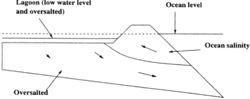
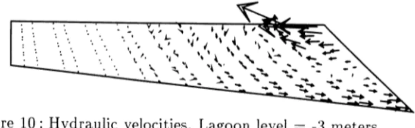
The lagoon level is lower than the sea level. Two zones can be distin-guished in the carbonate: 1) a shallow region restricted to the outer part of the platform where oceanic waters flow towards the lagoon; 2) a deeper region with hydraulic circulations directed oceanwards (Figures 8, 9 and 10).
Lagoon (low water level
and oversalted) Ocean level
Ocean salinity
Oversalte
Figure 8: High salinity lagoon behaviour
Figure 9: Salinity varies from 36psu in the ocean to 48psu in the lagoon
Computer Methods in Water Resources XII 549
Figure 10: Hydraulic velocities. Lagoon level = -3 meters.
4.2 Low salinity lagoons
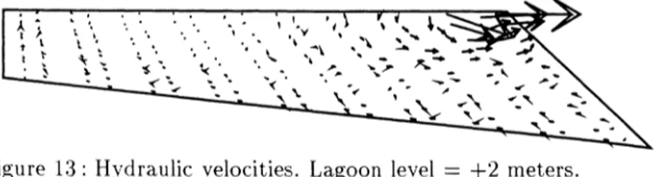
Again, two zones are observed: 1) on the top, waters with low salinity flow from the lagoon towards the ocean; 2) below this zone, hydraulic velocities are low and the salinity is close to that in the ocean (Figures 11, 12, and 13).
Lagoon (high water level
and undersalted) Ocean level
Low salinity
Ocean salinity (no circulations)
Figure 11 : Low salinity lagoon behaviour
Figure 12 : Salinity : 36psu in the ocean and 31psu in the lagoon
550 Computer Methods in Water Resources XII
Figure 13 : Hydraulic velocities. Lagoon level — +2 meters.
Conclusion
Interstitial circulations in coral reefs are well described by solving the coupling between Darcy's hydraulic equation and the salt and ther-mal equations. Open lagoon interstitial circulations are globally di-rected inwards due primarily to thermally induced density gradients. In contrast, groundwater circulations in atolls with enclosed lagoons are mainly due to lagoon salinity and water level. In both cases, the model results agree well with field data, confirming the ability of our model to describe the hydraulic behaviour of atoll carbonate plat-forms.
References
[1] De Marsily, Hydrogelogie quantitative, Masson PARIS 1981.
[2] Guille, Goutiere, Sornein, Les Atolls de Mururoa et Fangataufa, Masson PARIS, 1993.
[3] P. Verpeaux A. Millard T. Charras A. Combescure, A Modern Approach of Computer Codes for Strucctural Analysis, 10th Conf. on Structural Mechanics in Reactor Technology, Annaheim, USA, August 14-18, 1989.
[4] Leclerc, Broc, Jean-Baptiste Rancher, Steady state interstitial cir-culations in an idealised atoll reef and tidal transients in a deep bore-hole by computer simulation, Special publication Int. Ass. Sediment. 1997.