HAL Id: hal-00563242
https://hal.archives-ouvertes.fr/hal-00563242
Submitted on 4 Feb 2011
HAL is a multi-disciplinary open access
archive for the deposit and dissemination of sci-entific research documents, whether they are pub-lished or not. The documents may come from teaching and research institutions in France or abroad, or from public or private research centers.
L’archive ouverte pluridisciplinaire HAL, est destinée au dépôt et à la diffusion de documents scientifiques de niveau recherche, publiés ou non, émanant des établissements d’enseignement et de recherche français ou étrangers, des laboratoires publics ou privés.
Olivier Barreteau, Géraldine Abrami, Flavie Cernesson, Raphaëlle Ducrot,
Patrice Garin, Patrick Le Goulven, Pierre Maurel, Audrey Richard-Ferroudji,
Véronique Souchère, Caty Werey
To cite this version:
Olivier Barreteau, Géraldine Abrami, Flavie Cernesson, Raphaëlle Ducrot, Patrice Garin, et al.. Cities and their water socio-footprint: a dynamic socio-technical network. Cities of the Future, Mar 2010, Cambridge, United Kingdom. 10 p. �hal-00563242�
Cities and their “water socio-footprint”: a dynamic socio-technical network
O. Barreteau (Cemagref, UMR G-EAU), G. Abrami (Cemagref, UMR G-EAU), F. Cernesson (AgroParisTech,UMR G-TETIS), R. Ducrot (Cirad, UMR G-EAU),
P. Garin(Cemagref, UMR G-EAU), P. Le Goulven (IRD, UMR G-EAU), P. Maurel (Cemagref, UMR TETIS), A. Richard-Ferroudji(Cemagref, UMR G-EAU),
V. Souchère(INRA, UMR SADAPT), C. Werey (Cemagref, UMR GSP) Cemagref UMR G-EAU
361 rue Jean-François Breton, BP 5095 34196 Montpellier Cedex
France
ABSTRACT
Through examples of interactions among urban and rural areas we have built the concept of urban water socio-footprint, on the basis of concepts of water and urban footprints. This urban water socio-footprint entails making explicit the socio-technical network which disseminates the impact of urban activities on water system or due to their specific needs towards water system. Animating this footprint with people, their dynamics and migration, their concerns about various places leads to couple the dynamics of water system and land use in the whole urban systems, including built and non built, cultivated and non cultivated areas. This raises the issue of the existence of institutions to take in charger the links which are emerging through these multiple sources of interdependences.
KEYWORDS
Footprint, interdependences, feedback loops, land use, power relations.
INTRODUCTION
The increase of urban population and the evolution of life patterns result in an increase of needs of water from cities, but also of demand for flood protection, and of concerns regarding water quality. With an argumentation based on health and security for people, cities generate hence increasing constraints on their surroundings area, including for water management and land use. We propose in this paper an interdisciplinary framework to analyze the extent of the area constrained by cities due to water issues, to ensure that the amount of water of proper quality is available, that population is protected from flood, as well as consequences of urban activities. We consider this framework as an extension of the concept of urban water footprint. Cities are controlling an increasing space beyond the mere quantitative aspect of securing access to the resource.
This framework is being elaborated on the basis of five case studies of relations between cities and their hinterland, as part of a research project on Solidarity between Urban and Rural Places in relation with water management (SURGE). First section presents these case studies and the overarching objective framing this project. We define the network of places partially controlled by cities to help them meeting their objectives of water management as an “urban water socio-footprint”, which we describe in a second section. This space, is eventually made of places, and is not passively controlled however. In a second time we include in this framework the feedback from the “controlled” places to the controlling city. We argue that this feedback should be better considered by cities in order to improve their water management itself, and we propose some
ways to do it, as soon as concrete places can be identified as parts of the controlled space.
CASE STUDIES USED AS ILLUSTRATION
We have elaborated our framework on the basis of a review of literature on rural/urban interdependences and water management on one hand, and on water footprint on the other hand. We have also used the 5 case studies of an on-going project to illustrate the concept proposed in this communication.
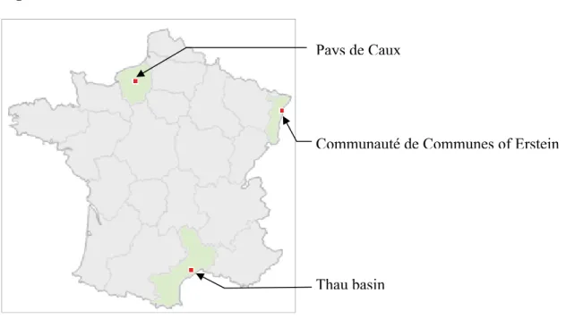
These case studies feature various situations of interactions due to water management between urban and rural areas. Three of them are in France (cf. figure 1): Thau basin in the South of France, Communauté de communes of Erstein in Alsace, and Pays de Caux in Normandie (North West of France).
Figure 1 - French case studies
Pays de Caux
Thau basin
Communauté de Communes of Erstein
Thau basin is characterized by small cities in the downstream part of the area along the coast of the Thau lagoon, and rural villages in the head of the basin. There are strong stakes of water quality and quantity, due to the fast population increase, and the leading economic role of shellfish farming industry in the area. Issues of political integration between the more rural northern part of the basin and the more urbanized and industrial coastal part, or even with the closest major city, Montpellier, are particularly currently very important in the area.
The Erstein case study features also an issue of political integration between the Communauté Urbaine de Strasbourg and a group of small and medium municipalities on its southern border. The main stake here is the control of the development of the area on the limit of Strasbourg built area, but also sharing water resources and sharing the cost of maintenance of existing domestic water and sewage networks.
The last case study, in Normandy, is partially covering the Rouen metropolitan area. Main issue is protection of domestic water holes and protection of built areas from erosive runoff and mud slides. All these three cases have to deal with the issue of political integration of municipalities within larger institutional frames which are taking over some of the devolution of its members. They are also at the crossroads between technical dynamics, with water and networks as the main focus, and political dynamics with future of the places as the main focus.
Besides these French cases, two South American cases provide contrast with diverse modes of interaction between urban and rural areas. Quito in Ecuador is increasing its network for bringing water to its growing population. This causes an overlap between indigenous rights and governmental laws for water use. The changes are fast in these places, which provide examples of adaptation of rural areas to expansion of the Capital’s network. Finally a Northeast Brazil case, in a rather rural area, is characterized by multiple use of water all across the system.
WATER SOCIO-FOOTPRINT
First section describes the urban water socio-footprint, at least for its parts that are generated in a direct interaction involving a city and another place. In a first time we consider it as the concept of water footprint, as it has been developed in the frame of Life Cycle Assessment (LCA), then we consider the reason for its expansion due to interaction with social systems, in the frame of urban systems.
Water footprint
With the model of Carbon footprint, scholars have developed the concept of water footprint with the aim of life cycle assessment. This assessment takes place in the frame of a specific product, from cradle to grave. Basic idea is to evaluate the total amount of water used in the whole life cycle of a given product. If we take the example of a can of tomato sauce, as in (Ridoutt & Pfister, 2010), this includes water used to grow tomatoes and other ingredients of the can, water used in the process of transforming these ingredients into the can of tomato sauce, eventually water required to use the product (here water needed to cook with this can of tomato sauce), and water needed to get rid of the wastes, including to compensate for quality loss.
While it appeared to be a quite straight calculation for Carbon footprint, extension to water is not so simple. This trend has been developed in considering several types of water: green water, blue water and gray water. This computation of total water used adds water which is not withdrawn from the system (green water), with water which is effectively withdrawn (blue water), and an equivalent of water amount to compensate for quality. Correcting for these different qualities of water lead for example to consider differently let’s say cheese, which is made mainly with the green water consumed in the grass growing process, and which would be consumed anyway by the vegetation in place in this area, or a cotton shirt, which is made with irrigated cotton . Moreover, as Ridoutt and Pfister point out, the same quantity of water withdrawn from a water body is not the same according to the context of water scarcity where it is withdrawn. One litre of blue water in the tropical forest of Ivory Coast for example can’t be assessed. Therefore Ridoutt and Pfister propose a water footprint corrected with the local context of scarcity where this water is withdrawn.
Water socio-footprint
Discussion about distinction according to type of water and local water availability starts actually to explore implicitly social components of water footprint, with the idea of taking in charge in the footprint other potential uses, for which water could be missing. Let’s go back to the example of the can of tomato sauce. Ingredients grown with green water don’t use water missing to other uses. Land may be a problematic resource, not water. While blue water used in irrigation of tomatoes will be potentially missing for other uses, especially in context of scarce resources. Gray water, or any way to take in account considerations of water quality, leads to other extension of water socio-footprint. Discharge of polluted water through an industrial process
modifies the potential further uses with this water. Eventual non point source pollution due to heavy use of pesticides in growing some ingredients of the can of tomato sauce can make the polluted water inadequate for some uses such as drinking water.
Correction of footprint with local water scarcity where it is produced is an interesting proposition to go further in the consideration of the eventually missed uses. However water scarcity is itself relative to current water uses. A switch from rain fed grassland for fields of intensive irrigated crops as the “normal” land use in a large space, and you will raise water scarcity in this place, without changing anything in the local climate.
The three types of water take already in charge a lot of impacts of one use of water on other people. It deals with water quantity and quality. It does not deal with the risk induced by water, and the impacts on water flows of a process. Production of energy with a dam for instance changes the flow in the river. Its balance of water consumption is very low, and changes on water quality are at worst marginal. However the flow is changed. These changes in flow are also at the capacity level: maximum flow possible in one place can change according to changes in land use. Supermarkets and their paved parking lots increase the potential runoff flow of its area. When using water footprint for LCA, Mila i Canals and colleagues (2009) consider this pathway of impact of land use on water cycle.
With water socio-footprint, we want to explore also the consequences of direct and indirect social links between people, concerned by the amount and quality of water available for them or present in an environment they care for. Social interactions lead to consider relations in other directions than water flows. This is a kind of reverse water footprint. Let’s move to the example of production of mineral water. Twenty years ago, Nestlé Waters started a process of dialogue with farmers in the whole catchment area of the sources used to produce “Eau de Vittel”, a high value mineral water in Northeast France (Benoît et al., 1997). They came up with an agreement with these farmers framing the land use in the catchment: crops and cropping techniques. Final aim of Nestlé was to decrease dramatically the need for gray water at the level of farmers upstream of the sources. We consider this control over land use to guarantee the possible use of water in a process as the water socio-footprint of the Vittel water.
Water socio footprint entails establishing the whole consequences of water use and needs in an industrial process. It internalizes the power relation between various users, which entail one user to control the use of another user: the consequence of an industrial process on water system is not only through the water it consumes or the quality degradation it generates, but also through the constraints it generates over kinds of land use for other people in other places. The
counterpart of this extension is that we don’t end up with a single value characterizing the footprint as it is used in LCA for comparative purposes and impact assessments. Such socio water footprint rather characterizes a water use, and makes explicit the relations of one water user with other concerned people due to water use. We consider the water socio-footprint as the socio-technical network generated during an industrial process by the use of water and the impact on water due to this process on the society related to these water bodies. We come back to potential uses of such footprint in the perspectives, but the possibilities for a true comparison is already problematic with water footprint due to the various categories of water and their meaning relative to scarcity in a place (Ridoutt & Pfister, 2010), which is itself dependent on current water uses in this place.
Urban water socio-footprint
system consumes water, modifies water and induce control on other places due to its water needs as well as other land use policies. Ecological footprint has been used to assess the ecological impacts of a city, as a matter of natural resource mobilization and modifications of natural habitats beyond its borders (Rees & Wackernagel, 1996). In the same way, cities have an influence on water system beyond its borders, and water footprint (Jenerette, Marussich et al., 2006; Jenerette, Wu et al., 2006) can be considered as a component of ecological footprint. This influence of cities on water system is valuable to assess, because it can be at the same time a source of tension due to the high sensitivity of people to water availability and quality, as well as a source of integration and exchanges due to the flowing character of water. This meaning of water footprint loses its link with the LCA perspective: the time of the city is supposed infinite from the assessment point of view, and the integration “from cradle to grave” does not make any sense. The integration is across a system, whose boundaries are defined by the unfolding of the whole socio-technical network starting from the city considered, and not through an industrial process.
The urban social water footprint includes obviously the space where resource is collected. Big cities, like Boston, Paris and many others, go as far as a hundred kilometers or more to ensure the availability of drinkable water for their inhabitants. This blue water useful as domestic water for the city could ensure the presence of wetlands in the places where it is withdrawn.
Preservation of water resource for domestic use by a city is a classic source of tension between rural and urban area of an urban system. This leads in some cases to failure in political
integration of municipalities around urban systems, as recommended (with strong financial incentives from the State) currently in France. In the case study of Thau basin, the issue of water resource management at the scale of the whole basin is very sensitive, and several villages are reluctant for a stronger political integration, which is a major local issue. Two major reasons lay behind these local tensions: (i) the will to control the evolution of its land use, and (ii) the control of water resource to keep it for agriculture or to preserve it for future domestic uses. A deeper integration could indeed lead to share with a new institutional integrated body the devolution of domains related to land use, or water management. In this case study main cities of the area on the coastal part seem not powerful enough yet to acquire control on these resources. In many places, major cities have more power and try to achieve control on some water resources beyond the limits of their jurisdiction.
From the point of view of the city, the quality of the water is also important. Still relative to securing resource of water, cities are willing to control the land use around the places where they collect water, even if money is not enough for them to get this control (Salles et al., 2006). Cities do not limit in the rural area blue water use only, but also gray water use. This limit on gray water is implemented through control on land use, leading to switch to the social footprint. In France, we observe a surge in the demarcation of “Bassin d’Alimentation de Captage”, which are the watersheds that bring water in the cities’ water reserves. Cities, or metropolitan institutions, take the control of these lands and then lease them to farmers with specific conditions on their cropping systems. This is usually done through various forms of contract between the
organisation in charge of management of the resource and the landholder themselves. This control on possibilities of land use is actually a much more important concern for rural
municipalities, while the possibility for selling land for new housing area is the main concern for land owners. In the Alsace case study, rural villages want to stay out of the main political
integration of the urban system, in order to keep control on their land use, and the potential for development of their village which is associated to it. As a mayor, leading an association of rather small municipalities close to the major city of Strasbourg, told us: “if a new borehole is dug in my village territory I will not be allowed to have any new activity at all, due to regulations of protecting water sources”. In France, association with the political integration trend of the main city urban system is the main stake in all local elections within smaller municipalities.
City does not consume water only, but also various goods. City needs several kinds of goods accessible only because of presence of water. Exploitation of these goods can modify heavily the water bodies from where they are taken. These can be either natural good, such as building materials removed from riverbeds, or industrially processed goods produced in stream such as fish farms or some kinds of hydraulic energy. Leisure activities related to water join this category as well. Many of these goods can actually be taken in charge with the category of gray water. Urban water socio-footprint includes also water used to produce the food and other goods consumed in the city. The identification of the places where this water comes from and the category of this water are much more difficult than in the case of blue water for domestic water. This water is usually referred to as “virtual water”: the water imported is not only the water contained in the good, but also the water needed to produce it. The relevant places are rather scattered all across the world already for a single product (Ridoutt and Pfister 2010). This is all the more true, when taking in account the extension of all the goods needed by a city. Hence, it is difficult that the corresponding space makes any sense for the city’s inhabitants. In that domain the current movement towards the consumption of local products should make easier the perception of these sources of virtual water as parts of a territory, i.e. a space appropriated by people leaving there. In Thau basin, the same rural municipality which is trying to keep its water sources for its development of farming is also working on the development of short farming industries, aiming at the markets of the city nearby for its products. The tension due to control of water sources is tempered here by the possibilities of exchanges.
Cities need also to protect their inhabitants from flood. Farm lands are good candidates for “over flooding”. This is explored through the setting of contractual compensations: farmers are paid for crop losses due to their acceptance of overflooding (Erdlenbruch et al., 2009). However this means a thorough evaluation of costs and potential gains attached to the field which is
overflooded. This is a complex assessment due to propagation of effects on local farming system and due to temporal and organizational dimensions of damage occurrence (Brémond et al., 2009). These assessment processes end up rather with a negotiation, exchanging control over land against some other benefits. This lost of control is easily identified, and can be included in the socio-water footprint.
Cities modify flow downstream as well. Even with good sewage treatment, cities are changing the quality of water downstream. Changes in land use, with an increase of impervious areas, modify the flow that a city releases downstream after a storm. Places downstream can thus see their uses impacted: seaside tourist resorts need good water quality to attract clients, which can be impeded by big cities upstream. Interestingly, these changes downstream are not due to direct action on water system but rather on political choices in land use, such as the development and urbanization of specific area.
Finally urban social water footprint should also encompass for positive amenities from city to its hinterland. Such positive relations provide reasons beside the mere possibilities of exchanges that make attractive for the hinterland a higher political integration (i.e. a share of control on land use) in the urban system. Access to services, sports and cultural amenities, and higher
subventions constitute the main part of these positive amenities (van Leeuwen, 2008; van Leeuwen & Nijkamp, 2006), and depend on the formal integration: citizen of a municipality which did not join an integrated level can be excluded of these services and amenities; level of subventions from state is higher for integrated organization. However, it does not fit really in the socio water footprint at least in a first order. However maintenance of infrastructures for
domestic water transportation and sewage treatment is sometimes too costly for small
case study, this sharing of maintenance cost is the main driver to lead some small municipalities to share some of their control over their water resource and land use.
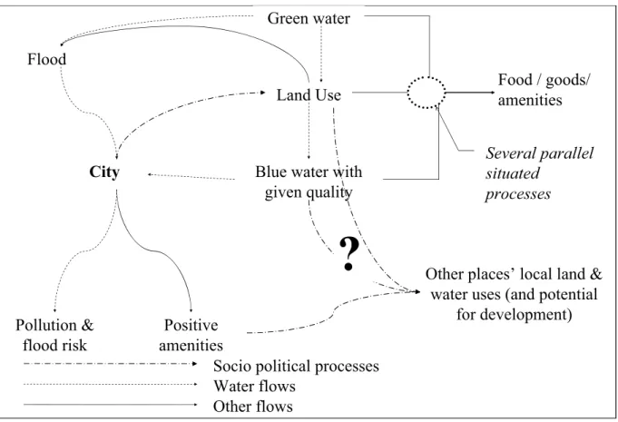
Figure 2 presents a generic synthesis of the technical network constituting the water socio-footprint of a city. Each flow is actually situated; we have presented here the categories of flows. An apparent feed back loop on the diagram may concern the categories and not the specific instances of these categories.
Figure 2 - Synthesis of urban water socio-footprint
Land Use Green water
Blue water with given quality
City
Food / goods/ amenities Flood
Other places’ local land & water uses (and potential
for development) Pollution & flood risk Positive amenities Several parallel situated processes
?
Socio political processes Water flows
Other flows
Land Use Green water
Blue water with given quality
City
Food / goods/ amenities Flood
Other places’ local land & water uses (and potential
for development) Pollution & flood risk Positive amenities Several parallel situated processes
?
Socio political processes Water flows
Other flows
MAKING THESE INTERACTIONS ALIVE: THE FOOTPRINT’S DYNAMICS
In this second section we pay more attention to people and the feedbacks they can mediate. Water moves, but people move too. And they act. Population dynamics, migrations, water uses change the nature of the urban water socio-footprint
People dynamics and migrations
Population increase and evolution of people’s standards of habitations lead to a rapid expansion of urban areas, as well as an evolution of water needs per habitant. On cities’ margins, urban sprawl increase water needs and push further away places where water reserves can be “generated”. These margins can also be identified but are often non-appropriated, as transition spaces, not any more rural, not yet urban. Several scholars working on these interstices in many geographical contexts have pointed out that these areas gather many marginal populations and
rejected people (Lacour & Puissant, 2007), that nobody takes care of them or look at them (Qviström, 2007). These areas are the usual place to extract resources and to store and handle wastes. They constitute also land reserves for future major infrastructures generating nuisances such as airport or sewage plant for the whole integrated urban system.
The usual dichotomy between urban and rural areas leaves these areas orphan, and makes difficult the management of specific environmental issues taking place on these spaces.
Control on this area is thus rather weak. Major city nearby meets thus little opposition in inducing constraints on these areas when needed. Indirectly it generates constraints through water system from city to rural areas: power of the central urban system increases with its population and the edge between densely built areas to less densely built moves forward bringing land use issues.
Migrations occur also on shorter time scale. People leave in places, work in other places, visit elsewhere, and have ties in yet other places. In developing countries people move at the season time scale, working in the fields during cropping seasons and in city the other part of the year (Smit, 1998). In France, even if a large majority of people leave in urban areas, most of them have strong ties and care for specific rural areas. Most people are not so much attached to one single specific place as it is assumed when they are categorized according to a specific identity usually related to their residential place. This multiple concern for places of people, and more specifically of those dependent on cities, generates feedback from the places reached by the urban water socio-footprint towards the cities’ residents, and through them to city government. A lack of amenities, an increase of poverty in a remote place of the socio-footprint, or changes in possible water activities will affect the tourist seeking this amenity, the relative coming from the city to visit parents in this remote place, or the city dweller attached to some specific activities from youth time in this place. At least people from cities can not be considered completely unconcerned by the water socio-footprint of their city, while they are contributing to its power. Other flows than migration exist between cities and the places reached through their water socio-footprint: job opportunities, money, cultural behavioral patterns. These flows can reinforce the influence of city on areas surrounding it along the water socio-footprint, but it can also pave the way for feedback loops towards the city.
People’s concern for water
People have a variety of relations to water resources in various places. Water is part of a production process: food production, drinkable water production, or some industrial processes. People involved in these industries have strategic concerns about water. Water is also highly connected to worldviews and principles. It can be considered as a functional part in industrial systems, or a public good, a key element of legacy, a natural element which should be preserved as such. Water is probably one of the elements in environment with which people have developed the most intimate relations, from their youngest age. Water is part of some cherished landscapes, former fishing or swimming places. Fountains and sources are places where specific or repeated meetings took place. Some cities are currently building at their scale on this widespread concern for water, to re-open urban streams which had been completely covered decades before (Simpson, 2004).
However there are a lot of various concerns, positive and negative: water as source of food, as a beautiful landscape, but also as a source of illnesses, as an awful “cesspit”. This variety of relations makes mere contractual relations less effective in dealing with the social consequences of controlling a resource. Even if local empirical knowledge is increasingly considered, the effective place of this knowledge in environmental policy is still unclear (Barthélémy, 2005). Further the “local empirical knowledge” category is plural. Several frames of understanding the
world, of representing views of the world lay behind this category. Central in the socio-footprint network, cities seek a commensuration between these pieces of knowledge, a mean to organize a debate. This heterogeneity of type of knowledge make very difficult for city officials to perceive the eventual feedbacks, because they are not equipped to grasp them.
Feedback loops
Finally feedback builds also upon the existence of the relation between city and other places through the water socio-footprint. In a case study dealing with Quito in Ecuador, we can see that places which started to provide water to Quito learned also to deal with the city. One of these places could for example mobilize this learning to get a new road. More generally, the agreement regarding the mobilization of the resource can be revised according to the evolution of power relations. This is true not only at the level of countries, but also in the relations between metropolitan areas and the places of their water socio-footprint.
We think that cities of the future should better take in account these feedbacks. They should think their relations with their water socio-footprint, as a bilateral and dynamic relation. For that we suggest the use of an institutional analysis approach extended to the diversity of relations between a metropolitan area and the places constituting its water socio-footprint. This means integrating the various flows, and paying attention to the variety of forms of attachment of people to the water resource and the sets of artifacts related.
CONCLUSION AND PERSPECTIVES
This communication has built a conceptual framework to make explicit the relations within the socio-technical network defined as the situation of a city within water system. We refer to this framework as to an urban water socio-footprint. Exploration of this footprint makes clear that the main stake in this network is land use control, because land holds water, but also because water use generates constraints on land use to guarantee a given quality, and because most land uses need water. It makes also clear that feedbacks are possible and that mobility of people and their sense of multiple places reinforce the occurrence of these feedbacks.
The existence of the entangled interdependences uncovered with this footprint generates possibility of tensions for land use and water use control. However it provides also opportunity for exchanges and the identification of concerned people. Institutions or even only arenas are required to transform this mere report into a real integration in order to handle the tension over land use. At least the exploration of the footprint can lead to identify orphan interdependences and to look for existing arenas which could be candidate to start taking them in charge.
ACKNOWLEDGEMENTS
This work is part of the on-going project “SURGE: Solidarité Urbain Rural et Gestion de l’Eau”, funded by French Environment Department, Centre National de la Recherche Scientifique, as part of their joint program “Eaux et Territoires”, and Institut Languedocien de l’Eau et de l’Environnement.
Barthélémy, C. (2005). Les Savoirs Locaux : entre connaissances et reconnaissance. Vertigo,
6(1).
Benoît, M., Deffontaines, J.-P., Gras, F., Bienaimé, E., & Riela-Cosserat, R. (1997). Agriculture et qualité de l'eau: Une approche interdisciplinaire de la pollution par les nitrates d'un bassin d'alimentation. Cahiers Agriculture, 6(2), 97-105.
Brémond, P., Grelot, F., Abrami, G., & Blanc, C. (2009). Modelling farm vulnerability to
flooding: towards the appraisal of vulnerability mitigation policies. EAAE PhD Workshop 2009, Giessen. Paper presented at the EAAE PhD Workshop 2009, Giessen,
Germany.
Erdlenbruch, K., Thoyer, S., Grelot, F., Kast, R., & Enjolras, G. (2009). Risk-sharing policies in the context of the French Flood Prevention Action Programmes. Journal of
Environmental Management, 91(2), 363-369.
Jenerette, G. D., Marussich, W. A., & Newell, J. P. (2006). Linking ecological footprints with ecosystem valuation in the provisioning of urban freshwater. Ecological Economics, 59, 38-47.
Jenerette, G. D., Wu, W., Goldsmith, S., Marussich, W. A., & Roach, W. J. (2006). Contrasting water footprints of cities in China and the United States. Ecological Economics, 57, 346-358.
Lacour, C., & Puissant, S. (2007). Re-urbanity: urbanising the rural and ruralising the urban.
Environment and Planning A, 39, 728-747.
Mila i Canals, L., Chenoweth, J., Chapagain, A., Orr, S., Antón, A., & Clift, R. (2009). Assessing freshwater use impacts in LCA: Part I—inventory modelling and characterisation factors for the main impact pathways. International Journal of Life Cycle
Assessment, 14, 28-42.
Qviström, M. (2007). Landscapes out of order: studying the inner urban fringe beyond the rural-urban divide. Geografiska Annaler: Series B, Human Geography, 89(3), 269-282.
Rees, W., & Wackernagel, M. (1996). Urban Ecological Footprints: Why Cities Cannot be Sustainable - and Why They Are a Key to Sustainability. Environmental Impact
Assessment Review, 16, 223-248.
Ridoutt, B. G., & Pfister, S. (2010). A revised approach to water footprinting to make transparent the impacts of consumption and production on global freshwater scarcity. Global
Environmental Change, 20, 113-120.
Salles, D., Barraqué, B., Busca, D., & Garin, P. (2006). L’eau des villes et l’eau des champs.
Négociation territoriale et génie de l’environnement. Programme Interdisciplinaire Développement Urbain Durable- D2RT Politiques Territoriales et Développement Durable. Rapport final. Toulouse: CERTOP-Cemagref-LATTS.
Simpson, J. T. (2004). Rediscovering the Bièvre: The Feasibility of Restoring Ecological
Functions in an Urban Stream. MIT, Cambridge, MA.
Smit, W. (1998). The rural linkages of urban households in Durban, South Africa. Environment
and Urbanization, 10(1), 77-87.
van Leeuwen, E. S. (2008). Towns Today. Contemporary Functions of Small and Medium-sized
Towns in the Rural Economy. Vrije Universiteit Amsterdam, Amsterdam, Netherlands.
van Leeuwen, E. S., & Nijkamp, P. (2006). The Urban-Rural Nexus. A study on extended Urbanization and the Hinterland. Studies in Regional Science, 36(2), 283-303.