Fuzzy Logic Approach for GNSS Signal
Classification Using RHCP And LHCP Antennas
Bassma GUERMAH
National Institute of Postsand Telecommunications, INPT, Morocco
Email: bassmaguermah@gmail.com
Tayeb SADIKI
International University of Rabat,UIR, Morocco Email:Tayeb.sadiki@uir.ac.ma
Hassan EL GHAZI
National Institute of Postsand Telecommunications, INPT, Morocco Email:elghazi@inpt.ac.ma
Abstract—Today, the problem of global navigation satellite
system (GNSS) positioning in urban canyons has received consid-erable attention in several field, such as transport and emergency systems. However, the performances of GNSS-based systems can be degraded in urban areas due to non-line-of-sight (NLOS), Multipath and masking effects.
In this paper, we aim to explore the potential of RHCP, LHCP antennas technology and the fuzzy logic method for identifying GNSS signal reception state. The fuzzy system developed has based on the satellite elevation and the C/N0-R-L, which is the difference between the left-hand circular polarized (LHCP) C/N0 (carrier-to-noise ratio) and the right-hand circular polarized (RHCP) C/N0.
A signal reception state classification by applying the proposed system is demonstrated on a real global positioning system (GPS) signal, and the efficiency of the classifier is shown.
Index Terms—GNSS systems; GPS, line-of-sight (LOS); NLOS;
Multipath; classification; fuzzy logic system; RHCP antenna; LHCP Antenna; urban area.
I. INTRODUCTION
GNSS-based location systems has received considerable attention in recent time and have penetrated critical domains, namely, maritime transport and civil aviation fields. However, The use of GNSS systems remains limited in urban environ-ment. The incoming GNSS signal can be reflected by the objects near of the receiver antenna, and consequently received as the sum of direct signal and several delayed replica, this phenomenon is called Multipath reception[1]. Furthermore, when the direct signal is blocked and the signal is received only via reflections, this is known as NLOS reception state[1]. The Multipath and NLOS phenomena disturb signal recep-tion, notably, adding a delay to the propagation time, and consequently, they can exhibit a positioning errors more than kilometer [2] .
In this paper, we address a very challenging problem related to GNSS signal reception state detection. Several methods exist for detecting and mitigating [3] NLOS and Multipath phenomena. In [4] and [5] the authors are used respectively a decision theoretic framework and statistical approach for NLOS signal identification. A non-parametric technique to distinguish LOS signal from NLOS is presented in [6]. In [7] the marginalized likelihood ratio test (MLRT) is used to detect the NLOS signals. A high quality antenna arrays[8][9] and C/N0 parameter[10] are also used to identify the NLOS
and Multipath reception state.
In this work, We explored the potential of the RHCP and LHCP antennas and fuzzy logic approach for detecting NLOS, LOS and Multipath signals.
The paper is organized as follows. Section II presents the background for this study including a review of the related work and a presentation of the proposed system model. In section III, GNSS signal state detection based of the fuzzy approach is presented. The GNSS signal classification test and analysis are presented in section IV.The final section concludes this paper and discuses future work.
II. BACKGROUND
A. Previous Work
The literature focusing on techniques for detecting the signal reception state is abundant. Previous investigations have shown that fuzzy logic approach can be applied to classify GPS data based on signal degradation conditions [11] [12] [13] [14]. In [11], a GPS-code-based measurements fuzzy processing is applied to detect the optimal observables, using the GDOP (Geometrical Dilution Of Precision) parameter and the signal-to-noise ration (SNR). Others works have applied fuzzy logic to detect the signal quality using C/N0 and the dilution-of-precision (DOP) [12] [13] [14]. However, the performance was still limited because the simple use of C/N0 is not sufficient to identify the signal reception state.
In [15], the fuzzy logic approach is applied to classify the data quality using the DOP value and the difference between the measured and excepted C/N0 as input fuzzy variables. In GNSS, we present three signal reception state, namely, LOS, NLOS and Multipath reception. The Line-Of-Sight(LOS) signal transmitted by satellites is right-hand circu-lar pocircu-larized (RHCP)[16]. When the signal is reflected, with an odd reflection number, the received signal become left-hand circular polarized (LHCP) [17]. In [8] the authors are used a dual-polarisation antenna for NLOS and Multipath detection basing on C/N0. However, the C/N0 is imprecise and uncertain measure. Consequently, in this study, we are exploited the ability of the fuzzy logic approach of handling different types of uncertainty, combined with the potential of the RHCP and LHCP antennas [18] to classify the received signal.
B. System model Description
The proposed classifier system is composed by two anten-nas, RHCP and LHCP. We assume that the antennas are placed too close together and at the same height.
The proposed GNSS receiver system is merged with the fuzzy logic system and provides an output the information about the signal reception state.
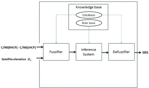
The schematization of the proposed classifier system is given in figure 1.
Figure 1: A schematic set-up of the proposed classifier system
III. PREDICTION OFGNSS SIGNALRECEPTION STATE APPLYINGFUZZYMODEL
A fuzzy classifier system is a classifier based on fuzzy logic using knowledge and regulations. At the heart of a fuzzy system exists a knowledge base consisting of fuzzy if-then regulations.
The fuzzy system is linked to human reasoning with uncertain and imprecise input data. Several fuzzy logic control systems with different principles are present.
To perform the reasoning process of GNSS signal state classi-fication, we have chosen to applied the fuzzy inference system using Mamdani method to design our classifier system. Our system has two inputs including satellite elevation and C/N0-R-L defined as subtraction between C/N0 value provided by the RHCP Antenna and C/N0 value provided by LHCP, as well as one output which indicates signal reception state. Our reasoning and decisions are based on real experimental study, results approved by signal model and previous work existing in the literature.
A. fuzzy classifier design
The architecture of the proposed fuzzy inference system for GNSS signal state classification is shown in figure 2.
The fuzzy system was designed using the Matlab Fuzzy Logic Toolbox. Firstly, we presented the C/N0-R-L parameter by a triangular membership function as shown in figure 3. The x axis represents C/N0-R-L (in dB-Hz) from -60 to 0 as Low, 0 to 10 as Medium, and 10 to 60 as High. The y axis represents membership function of Low C/N0-R-L value, Medium C/N0-R-L value and High C/N0-R-L value.
The curve for membership function of the satellite elevation has been shown in figure 4. The elevation less than 25 is considered as Low, 20 to 50 as Medium and upper to 50 as High.
According to signal model, experimental results and previous work, the choice of the Linguistic variable and the boundary values which characterizes each variable are based on the following arguments :
• If the direct signal is blocked and only reflected signals are being received, then the signal received by the RHCP antenna will be multiplied by an attenuation coefficients, which their value are less than 1.
• If the LHCP antenna can not track the incoming signal, the received signal can be considered as a direct signal.
• If the RHCP antenna can not track the incoming signal, the signal can be considered as a reflected signal.
• The C/N0-R-L based thresholds for Multipath signals are inspired from Ziyi Jiang and Paul D. Groves study [8].
• When the signal is at high elevation, the received signal will be Weakly attenuate.
• N reflections has been considered, where N is an odd number.
• The delay dependent carrier phase between the RHCP and LHCP signal is null.
Furthermore, the output of the fuzzy system is a numeric value ”SRS” between 0 and 1, which describes the signal reception state and was used to classify the received signal. The curve of membership function for SRS have been shown in figure 5. In this figure, the SRS is defined in a universe from 0 to 1 and linguistically characterized by three triangular mem-bership functions, labeled ”N”, ”M” and ”L”. An instinctive design to fit the feature of the centroid of area defuzzification output is applied to define the boundary values between near membership functions. The boundary values was choice at the medium between the corresponding membership functions. If the value of SRS is less to 0.375, the received signal is classified as NLOS signal. If the value of SRS is upper to 0.625, the received signal is classified as LOS signal. Thus, if the SRS is from 0.375 to 0.625, the GNSS signal is classified as Multipath signal.
Therefore, the if-then regulations for the inference fuzzy system, have been defined as below :
• If C/N0-R-L is High and satellite elevation is High then signal reception state ”SRS” is LOS.
Figure 2: Conceptual structure of a fuzzy system
Figure 3: Curve of membership function of C/N0-R-L
Figure 4: Curve of membership function of satellite elevation
Figure 5: Curve of membership function of SRS
• If C/N0-R-L is Low and satellite elevation is High then SRS is NLOS.
• If C/N0-R-L is Low and satellite elevation is Medium then SRS is NLOS.
• If C/N0-R-L is Low and satellite elevation is Low then
SRS is NLOS.
• If C/N0-R-L is High and satellite elevation is Medium then SRS is LOS.
• If C/N0-R-L is Medium and satellite elevation is High then SRS is Multipath.
• If C/N0-R-L is High and satellite elevation is Low then SRS is LOS.
• If C/N0-R-L is Medium and satellite elevation is Low then SRS is LOS.
• If C/N0-R-L is Medium and satellite elevation is Medium then SRS is Multipath.
IV. GNSS SIGNALCLASSIFICATIONTEST
A. Hardware and Data Acquisition
The experimental data are acquired in real environment, Calais, France, in collaboration with LISIC Laboratory at the University of the Littoral Opal Coast (ULCO).
The antennas used are a RHCP and LHCP antennas, powered by two Novatel receiver and attached to splitter, linked to a SILICOM machine for receiving GNSS signal.
To examine the performance of the proposed GNSS classifier system, a signal acquisition was taken at the park of the University Littoral Opal Coast (ULCO). A car has been equipped by two antennas (RHCP and LHCP antennas) and a reflector has been installed on the roof of the car, as indicated by the yellow marker in Figure 6.
B. Test and Analysis
In this experimental study, two scenario are considered. In the first scenario, the tracked satellites are in direct visibility to the antennas. In the second scenario, a reflector panel has been implemented for generate the signal reflexions, and a Multipath reception state detection is expected from the fuzzy classifier.
Figure 6: The data collection point at the park of the University Littoral Opal Coast, Calais, France
1) Scenario 1: We tracked the satellites in direct visibility
to the antennas. The figure 7 shows all the satellites present in the first signal recording . All recorded signals are taken on the same day and shifted by a time interval of 50 minutes. As shown in figure 7 the satellites in direct visibility are 24 15, 12, 13 and 19. The vehicle is presented on the skyplot by a black rectangle.
Figure 7: scenario 1 - the satellites skyplot for recording 1 The satellite skyplot for the second recording is shown in figure 8. We tracked the satellites 12, 15 and 24. We notice a remarkable change of elevation for these satellites.
To test the performance of the proposed fuzzy system, we computed the C/N0-R-L and satellite elevation for each satel-lite cited above and we applied the fuzzy inference classifier to detect the signal reception state, in order to compare the provided results with the expected state.
Table I summarizes the results obtained by the proposed fuzzy classifier for satellites tracking in scenario 1.
2) Scenario 2: We tracked the satellites which the
trans-mitted signals are undergo reflections by the reflector panel installed on the roof of the car.
The figure 9 shows the satellites skyplot for the first signal recording.
As shown in figure 9 the signal transmitted by satellite 12
Figure 8: scenario 1 - the satellites skyplot for recording 2
will be reflected by the reflector. Therefore the signal will be received in Multipath state. The vehicle and reflector are presented on the skyplot respectively by an orange arrow and a black rectangle.
Figure 9: scenario 2 - the satellites skyplot for recording 1 The satellite skyplot for the second recording is shown in figure 10. We tracked the same satellite (PRN 12) which its elevation has changed. Tables I and II summarize the results
Figure 10: scenario 2 - the satellites skyplot for recording 2 obtained by the proposed fuzzy classifier for satellites tracking in scenario 1 and 2. We observed that in scenario 1, all signals are classified as LOS and that corresponds to the expected
Scenario 1 - Recording 1
Satellite ID 12 13 15 19 24
Satellite elevation 33.18 33.94 60.31 31.79 65.94
C/N0-R-L 11.99 14.23 51 12.63 18.05
Signal state classification provided by the fuzzy classifier LOS LOS LOS LOS LOS Scenario 1 - Recording 2
Satellite ID 12 15 24
Satellite elevation 58.39 35.88 87.68
C/N0-R-L 20.62 18.00 17.29
Signal state classification provided by the fuzzy classifier LOS LOS LOS Table I: Signal reception state classification for scenario 1
Scenario 2 - Recording 1
Satellite ID 12 24
Satellite elevation 37.82 70.25
C/N0-R-L 13.44 18.49
Signal state classification provided by the fuzzy classifier Multipath LOS Scenario 2 - Recording 2
Satellite ID 12 15 25
Satellite elevation 79.01 17.31 34.22
C/N0-R-L 15.77 6.69 7.27
Signal state classification provided by the fuzzy classifier LOS Multipath Multipath Table II: Signal reception state classification for scenario 2
result. For Scenario 2, we notice that the signal reception state for satellite 24 in recording 1 and satellite 12 in recording 2 is LOS, and this result verify the argument cited above that the satellite at high elevation have a low probability to be destructed. Consequently, the signals are considered received as LOS signals.
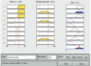
Therefore, the classification result given by the proposed fuzzy inference system has been shown in figure 11. For illustration, we have taken as an example an input crisp values of 20.62 and 58.39 for C/N0-R-L and satellite elevation respectively. The defuzzified output provided by the system is 0.75. Consequently, we can conclude that the GNSS signal is classified as LOS signal.
Figure 11: structure of Fuzzy Inference System according to target inputs and output
From the experimental results, the effectiveness of the pro-posed fuzzy classifier system has been clearly demonstrated.
V. CONCLUSIONS AND FUTURE WORK
This paper has proposed as new method to classify GNSS signal reception state using RHCP and LHCP antennas and fuzzy approach. The signal classification is characterized by two measures, namely, satellite elevation and C/N0-R-L which is the difference between the C/N0 from RHCP and LHCP antennas.
The classification measures are uncertain and imprecise. Con-sequently, a fuzzy approach has been applied. A fuzzy system, developed in the Matlab environment is presented with fuzzi-fication, inference engine and defuzzification steps.
The main result obtained in this work, is that the RHCP and LHCP antennas combined with the fuzzy processing have demonstrated their capability and effectiveness to distinguish between the signal reception state.
Our future work will be focused on applying the proposed system to show their impact on positioning accuracy.
ACKNOWLEDGMENTS
This work was financially supported by the National Center of Scientific and Technical Research (CNRST), Morocco. We thank Mr Serge Reboul, Mr Georges Stienne and Mr Jean-Bernard Choquel from ULCO university (LISIC laboratory) for their assistance in data acquisition.
REFERENCES
[1] PD Groves, “Gnss solutions: Multipath vs. nlos signals. how does non-line-of-sight reception differ from multipath interference,” Inside GNSS
Magazine, vol. 8, no. 6, pp. 40–42, 2013.
[2] Bassma Guermah, Hassan El Ghazi, Tayeb Sadiki, Yann Ben Maissa, and Esmail Ahouzi, “A comparative performance analysis of position estimation algorithms for gnss localization in urban areas,” in Advanced
Communication Systems and Information Security (ACOSIS), Interna-tional Conference on. IEEE, 2016, pp. 1–7.
[3] Mohammad Zahidul H Bhuiyan, Xuan Hu, Elena Simona Lohan, and Markku Renfors, “Multipath mitigation performance of multi-correlator based code tracking algorithms in closed and open loop model,” in
Wireless Conference, 2009. EW 2009. European. IEEE, 2009, pp. 84–
89.
[4] Joan Borras, Paul Hatrack, and Narayan B Mandayam, “Decision theoretic framework for nlos identification,” in Vehicular Technology
Conference, 1998. VTC 98. 48th IEEE. IEEE, 1998, vol. 2, pp. 1583–
1587.
[5] Sauoradeep Venkatraman and Jr Caffery, “Statistical approach to non-line-of-sight bs identification,” in Wireless Personal Multimedia
Communications, 2002. The 5th International Symposium on. IEEE,
2002, vol. 1, pp. 296–300.
[6] Sinan Gezici, Hisashi Kobayashi, and H Vincent Poor, “Nonparametric nonline-of-sight identification,” in Vehicular Technology Conference,
2003. VTC 2003-Fall. 2003 IEEE 58th. IEEE, 2003, vol. 4, pp. 2544–
2548.
[7] Cheng Cheng, Jean-Yves Tourneret, Quan Pan, and Vincent Calmettes, “Detecting, estimating and correcting multipath biases affecting gnss signals using a marginalized likelihood ratio-based method,” Signal Processing, vol. 118, pp. 221–234, 2016.
[8] Ziyi Jiang and Paul D Groves, “Nlos gps signal detection using a dual-polarisation antenna,” GPS solutions, vol. 18, no. 1, pp. 15–26, 2014. [9] Saeed Daneshmand, Ali Broumandan, Negin Sokhandan, and G´erard
Lachapelle, “Gnss multipath mitigation with a moving antenna array,”
IEEE Transactions on Aerospace and Electronic Systems, vol. 49, no.
1, pp. 693–698, 2013.
[10] Juliette Marais, D-F Nahimana, Nicolas Viandier, and Emmanuel Duflos, “Gnss accuracy enhancement based on pseudo range error estimation in an urban propagation environment,” Expert systems with applications, vol. 40, no. 15, pp. 5956–5964, 2013.
[11] N Crocetto, S Ponte, G Puglianoc, and L Savino, “Fuzzy-logic based methodologies for mobile mapping: Enhancing positioning accuracy of gps/gnss measurements,” THE INTERNATIONAL ARCHIVES OF THE
PHOTOGRAMMETRY, REMOTE SENSING AND SPATIAL INFORMA-TION SCIENCES, vol. 36, 2007.
[12] Chung-Jie Lin, Yung-Yaw Chen, and Fan-Ren Hang, “Fuzzy processing on gps data to improve the position accuracy,” in Fuzzy Systems
Sym-posium, 1996. Soft Computing in Intelligent Systems and Information Processing., Proceedings of the 1996 Asian. IEEE, 1996, pp. 557–562.
[13] A Ghalehnoe, K Mohammadi, and MR Mosavi, “Improve determining the location of a moving body on map by low cost gps receiver,” in
Research and Development, 2002. SCOReD 2002. Student Conference on. IEEE, 2002, pp. 242–244.
[14] JH Wang and Y Gao, “Evaluating the accuracy of gps positions under severe signal-degradation using adaptive-network-based fuzzy inference systems (anfis),” in 50th CASI Annu. General meeting and Conf.,
Canadian Aeronautics and Space Inst., Montr´eal, Quebec, Canada,
2003.
[15] Jau-Hsiung Wang and Yang Gao, “Identification of gps positioning solutions deteriorated by signal degradations using a fuzzy inference system,” GPS Solutions, vol. 8, no. 4, pp. 245–250, 2004.
[16] Ke Zhang, Baiyu Li, Xiangwei Zhu, Huaming Chen, and Guangfu Sun, “Nlos signal detection based on single orthogonal dual-polarized gnss antenna,” International Journal of Antennas and Propagation, vol. 2017, 2017.
[17] Matthew Brenneman, Jade Morton, Frank van Grass, and Chun Yang, “Mitigation of gps multipath using polarization and spatial diversities,” 2008.
[18] Lin Xie, Xiaowei Cui, Sihao Zhao, and Mingquan Lu, “Mitigating mul-tipath bias using a dual-polarization antenna: Theoretical performance, algorithm design, and simulation,” Sensors, vol. 17, no. 2, pp. 359, 2017.