HAL Id: hal-00339480
https://hal.archives-ouvertes.fr/hal-00339480
Submitted on 20 Apr 2009
HAL is a multi-disciplinary open access
archive for the deposit and dissemination of
sci-entific research documents, whether they are
pub-lished or not. The documents may come from
teaching and research institutions in France or
abroad, or from public or private research centers.
L’archive ouverte pluridisciplinaire HAL, est
destinée au dépôt et à la diffusion de documents
scientifiques de niveau recherche, publiés ou non,
émanant des établissements d’enseignement et de
recherche français ou étrangers, des laboratoires
publics ou privés.
Outdoor Augmented Reality: State of the Art and Issues
Imane Zendjebil, Fakhr-Eddine Ababsa, Jean-Yves Didier, Jacques Vairon,
Luc Frauciel, Martin Hachet, Pascal Guitton, Romuald Delmont
To cite this version:
Imane Zendjebil, Fakhr-Eddine Ababsa, Jean-Yves Didier, Jacques Vairon, Luc Frauciel, et al..
Out-door Augmented Reality: State of the Art and Issues. 10th ACM/IEEE Virtual Reality International
Conference (VRIC 2008), Apr 2008, Laval, France. pp.177–187. �hal-00339480�
Outdoor Augmented Reality: State of the Art and Issues
I. M. Zendjebil
(1), F. Ababsa
(1), J-Y Didier
(1), J. Vairon
(2), L. Frauciel
(2), M. Hachet
(3),
P. Guitton
(3)R. Delmont
(4)(1) IBISC Laboratory, CNRS FRE 2873. 40, rue du Pelvoux. 91020 Evry (2) BRGM – Systems and Information Technologies. BP 36009. 45060 Orléans Cedex 2 (3) IPARLA Project (INRIA - LaBRI). 351, cours de la Libération. 33405 Talence Cedex
(4) ARCHIVIDEO. 40, rue des Veyettes. 35051 Rennes
Abstract
The goal of an outdoor augmented reality system is to allow the human operator to move freely without restraint in its environment, to view and interact in real time with geo-referenced data via mobile wireless devices. This requires proposing new techniques for 3D localization, visualization and 3D interaction, adapted to working conditions in outdoor environment (brightness variation, features of displays used, etc.).
This paper surveys recent advances in outdoor augmented reality. It resumes a large retrospective of the work carried out in this field, especially on methodological aspects (localization methods, generation of 3D models, visualization and interaction approaches), technological aspects (sensors, visualization devices and architecture software) and industrial aspects.
Keywords: Outdoor augmented reality, 3D
localization, generation of 3D models, 3D visualization, 3D interaction, AR technology.
1
Introduction
Augmented Reality (AR), which enriches the real world by adding virtual entities, offers great potential and opens doors for new applications. In recent years, many augmented reality systems have emerged. However, the vast majority of these systems are intended for small indoor environments easy to control that limit the problems often encountered in AR (brightness variation, occlusion, 3D registration, etc.).
The advances made in computer vision and mobile computing allow to develop more complex AR applications, intended for outdoor environment, where working conditions are hard to control (sunlight, unrestricted mobility, etc.), and where different types of sensors can be used. Outdoor augmented reality presents several problems that are still the subject of intense research, including the 3D localization, visualization and interaction on mobile devices, the use of geo-referenced data, etc.
This paper presents a recent state of the art on outdoor augmented reality organized in six sections: In the first section, we will present the challenges and issues of mobile AR. The second section will expose outdoor AR problems. Then, we will present
and describe the various techniques developed for AR mobile. The fourth section is a technological survey. An overview of the major projects in this field will be described in the fifth section.
2
Outdoor AR challenges
The development of an outdoor AR system presents real challenges whether in technology, in methodology or in industry. Indeed, the development of an AR mobile platform will:
- Explore the synergy between augmented reality and mobile computing;
- Develop an architecture (hardware and software) suited for outdoor environments; - Explore and develop new 3D localization methods which take into account the real conditions of outdoor environments (variations in brightness, occlusion, etc.);
- Give the operator access to complex technical data during its interventions;
-
Study augmented reality architecture that allows to view geo-referenced data;-
Develop new interaction methods and visualization approaches on mobile devices.Industrial issues of outdoor AR applications are very important, especially in cultural heritage, environment and tourism. Indeed, the technological advances allow to deploy and to democratize AR in industrial domains.
3
Outdoor AR issues
The scientific issues relating to outdoor AR mainly consist in developing new techniques on the fields of: localization, 3D visualization and interaction on handheld devices.
The mobility of the operator in an unrestricted and unprepared environment makes difficult localization process. Usually, we combine an absolute location with a relative localization to improve a continuous operator’s localization. The absolute location is to estimate position using for example a GPS. The relative location uses sensors’ motion like accelerometer or gyroscope to estimate the relative displacement of the operator referred to a reference position. 3D models of the environment are typically used to initialize localization procedure. The problem of accurate localization in natural environment and 3D registration (unknown
surrounding, multiple sources of information, risk of occultation) is still an opened field of research.
In addition, outdoor augmented reality applications need a 3D virtual representation of the environment that reproduces enough realistically the real environment. Indeed, the 3D models are very useful for the pose estimation from a 2D/3D matching. The construction of simple and rich 3D models is a major challenge for AR.
The information available to the operator in the ground is often huge. Display these data, in real time; on handheld devices which have a limited processing power and low storage space is another problem that arises in mobile augmented reality.
Finally, the AR applications must allow handling and interacting with 3D data displayed to the operator. This task is accomplished through an interface. In conventional terminals such as PC, tools for interaction are based on WIMP concepts (windows, icons, menus, etc.). Outdoor augmented reality applications introduce new challenge due to the new mobile devices used (HMD, PDA, cellular phone, etc.). This requires proposing new Human/Machine Interaction approaches.
4
Mobile augmented reality techniques
4.1 Pose Estimation methods
In AR applications, it is important to know the position and orientation of the camera (also called camera pose) because it ensures the spatial and temporal coherence of the augmented scene. Indeed, camera pose allows to create a virtual camera with the same characteristics which is used to rend virtual entities overlaid the real images. This allows us to properly align real and virtual worlds. There are two main classes of pose estimation methods: marker-based methods (or fiducials) and markerless methods.
Marker-based methods use artificial markers placed in the real scene to estimate pose estimation. These markers are easy to detect and can contain codes that help to distinguish between them. Their positions in the real world are known a priori. Pose estimation contains the following steps: markers detection, 2D/3D matching, and finally estimate the camera pose. Two types of markers are commonly used: circular ones and square ones. The circular markers are quite invariant to perspective distortions, and their gravity center provides a stable 2D position. We mention the Concentric Contrasting Circle (CCC) markers [20] (black circle on a white background or vice versa), and colored concentric rings [51] [8]. The square markers were introduced by [28]. With the success encountered by ARToolKit library [25], their use has become widespread. The markers used in this library have black borders on a white background. The internal "pattern" contains a code to identify the marker. The main drawback of marker-based methods is
theirs need of artificial markers placed in the real scene which is not always possible.
Markerless methods exploit the natural features existing in the real scene such as the corners [30], edge and line segments [12][55][9], etc. The 2D data extracted from the images of the scene are matched with 3D data extracted from a 3D model of the scene. The use of models can improve the robustness and performance of the pose estimation methods. For example, in [30], Lepetit & al. propose a pose estimation method based on points. The method uses a partial 3D model of the scene. Their algorithm contains two phases: an automatic initialization phase during which the points of interest are detected in the reference images of the object to track, and a tracking phase. The pose is estimated using a 2D/3D matching and RANSAC algorithm. Edge-based methods [12] consist in extracting the edges of a 3D model and project them in image according to the previous pose estimation. The pose is obtained by minimizing the difference between the predicted position of contours and their current position in the image. In addition, Comport & al. [9] present a reliable method formulated as a virtual visual servoing approach. The model-based method proposed uses local edge tracking. The control law of closed loop minimizes the error between the current position and the desired position of the camera. Comport uses an M-estimator for handling outliers. This method is robust to partial occlusions and changes of illumination. The proposed approach converges fast enough for small displacements.
Simon & al. [50] have developed a method to track planes and recover the pose of the camera. They use the RANSAC algorithm to estimate robustly the best homography that relates the points belonging to the same plan in successive frames. The method is distinguished by its robustness to occultation, its speed. This method is easy to implement and very accurate. However, it presents a risk of drift due to the errors accumulation. We can also find texture-based tracking approach to estimate camera. It does not require the extraction of features such as contours or points of interest, but generally use all information of the pattern [31][17][24][52]. Jurie and Dhome [24] proposed a template-based method. The idea is to estimate the differences between the current image and the image warped using predicted pose. These differences allow to update pose parameters. In ARCHEOGUIDE project, Stricker & al. [52] described an approach based on a formal correlation matching between current image and references images of the real scene. The algorithm selects reference image with the highest score which allows to deduce 2D transformation between this image and the current image. From this transformation, we can extract camera parameters. Edge-based methods have the advantage of being robust to changes in
illumination, but they are unsuited to textured scenes. However, the textures-based methods are robust to occlusions but remain highly sensitive to illumination changes. So, a new category of methods has been emerging called "hybrid methods". These methods combine different visual features, such as edges and texture [45][36]. For example, the approach developed by Vacchetti & al. [53] combines contours and interest points. The camera pose is obtained simultaneously by minimizing point’s re-projection error and distance between the edges and projected of 3D edges on image.
4.2 Generation of 3D models
(a) (b) Figure 1: Example of data used for 3D reconstruction (a) Vector data (b) NSM Augmented reality systems need a virtual representation of the real environment. Indeed, this 3D model will be used for localization process and occlusions handling. Therefore, the generation of this environment is based on real data. These data are provided by different sources such as:
-Aerial photography: images acquired from aircraft, helicopters, satellites, etc;
-Numerical Surface Model (NSM): a digital representation of the topography of the environment (see figure 1.b) (forms and details visible on the ground);
-Vector data: include building prints (see figure 1.a) (the surface or up to a height of the building) and elements ridge (geometry of the roof of buildings);
-Oblique photos;
-Clouds points acquired by a scan; -Terrain’s photos and video;
Most of existing tools need a human hand to intervene in the reconstruction process. This makes them inadequate for large-scale reconstruction. Among these softwares, we can cite the photogrammetric software developed by GTA Geoinformatik Company, and SketchUp from Google Company. Concerning automatic approach, Lafarge [29] (laboratory MATIS) proposed methods using aerial data (photo, NSM, DTM, etc.). These approaches provide good results but are not yet in industrial phase. Also, we find other cloud points based methods provided with 3D scanners to construct 3D meshes. Some techniques are based on building prints. The system CityEngine proposed by Müller [38] uses a grammar for a parameterizable reconstruction of urban environments (see figure
2.b). It also allows to adjust the level of details depending on the selected quality. However, it is necessary to define the grammar for the city we would like to reconstruct. Müeller [39] improves his CityEngine by adding a module for analysis facade's photos to automatically generate the adapted grammar for each building.
Archivideo proposes FastBuilder for the large scale reconstruction of urban environment (Figure 2.a). This system is based on heuristics to fill in the gaps. The reconstruction uses a library of facades adapted to the city (~500 facades) and classification buildings depending on their style to fit the model. The reconstruction rules can be changed throughout the city, street or building. This system allows rapid reconstruction and can be tailored to specific needs.
(a) (b)
Figure 2: Examples of 3D models of urban environment: (a) FastBuilder (b) CityEngine Hoeim [21] uses image-based method for the reconstruction of a simple model. The method consists in segmenting the image in different classes (such as sky, ground, vertical, etc.) which can divide images in planes (like Children books). Idem, Cornelis [10] detects objects outside the perspectives plans. Then, it becomes possible to add a 3D representation in the model and expand the area of validity of the model (wider area is covered).
4.3 3D visualization
The techniques proposed in computer graphics require adaptations depending on features of mobile devices (limited processing and storage space). We can adopt a remote rendering approach that follows a client/server scheme. In client part, we can recover user interaction and display images calculated by a distant server.
More recently, different implementations of these approaches have been proposed (see [44]) adapted to mobile devices such as personal digital assistants (PDA). These techniques give good results but require excellent connectivity between server and client, which is often difficult to guarantee in a real mobility context.
The adaptive rendering techniques include algorithms that can regulate in real time the amount data to be displayed according to available client resources. The strong point of these technologies is it can operate on a class of heterogeneous devices like handhelds. For example, Magellan [35] is a visualization platform developed at IRISA which
aims to ease the development of new solutions for 3D interactive visualization on heterogeneous devices. It provides a set of system classes encapsulating callback system (sockets, threads, etc.) in order to ensure portability. Magellan system is then multi-platform (Windows/ Linux/SunOS). Iparla team extends Magellan to mobile devices using mobile Windows Operating System (for Pocket PC and Smartphone). The new version, called Elkano, includes: a module of distributed rendering, modeling language X3D, the ability for the server to build scene graphs, etc.
4.4 3D interaction
The interactions between a user and an application are through interfaces. In desktop computers case, these interfaces are mainly based on the model WIMP (Windows, Icons, Menus, Pointing device.).
The constraints imposed by mobile devices are different. Then, the Human/Machine Interaction has to change. For example, in case of input text, T9 and Triple Tap have been developed to address the absence of keyboard. For 3D interaction, we need to create similar interface.
Interacting with 3D computer-graphics is a complex process. Usually, there are two major tasks: manipulation and navigation in 3D scenes:
1. Manipulation: any object’s movement in space can be represented by 6 independent geometric transformations, which are translations along the 3-axes (x, y, z) and rotations around the same axis. Thus, if we wish to allow the user to move an object freely, it is necessary to allow it to operate on 6 Degrees of Freedom (DOF). 2. Navigation: it can be divided into two components: travel component which allows the movement of the actual view to another and way finding component also called cognitive component which corresponds to processes set to identify, apprehend 3D environment, or find a path to achieve a specific task (eg exploration, research, predefined movement).
There are several devices for 3D interaction on handheld devices, namely touch screens, buttons, cameras, and the positions and orientations of mobile devices. For example, for the touch screens, the interactions are based on gesture, drawing or pointing. The use of menus is difficult because of the small screen size (that would make it hide a large part of the view). In addition, several interfaces are based on gestures such as Scriboli [19] (Figure 3). In a browser, it is possible to designate the point of interest [34]. This technique is widely used in 3D applications under the name of "Go to". The displacement velocity will be depending on the distance between the observer point and the arrival point. Other techniques, such as using a "virtual Sphere" [5] or Ware set techniques, Eye in Hand, Scene in Hand, Flying
Vehicle [54], which are now standard tools, can be used.
Figure 3: Scriboli approach [19]
A lot of research is conducted on the use of a single button to move. Among the techniques, we found HoverCam [26] or UniCam [57]. These techniques are based on the recognition of gestures, and prediction on the user intents. In the case of object manipulation, the techniques developed for Pc are used, such as "Jack" [4] or "Skitter" [40], which are controllers. However, it should be noted that the control of these interfaces is more difficult with a stylus as a mouse. The advent of touch screens with several points on mobile devices makes possible to consider the use of techniques such as method proposed by Hancock & al. [18] or approach developed by Zeleznik & al. [58]. These techniques allow manipulating 3D objects using multiple points, to define the center and angle of rotation, or by "grabbing" object to handle. In the case of 3D interaction, the use of the keyboard is a problem due to the binary signal. For example, in the navigation case, it is difficult to determine the movement velocity when pressing a button. But several strategies have been developed. For example, the selection of a point by using keys allows to move a cursor, but this shift can be long.
To improve the selection phase, some studies have been conducted. To select a particular item on the screen, Hachet & al. propose Jump and Refine technique [16] (figure 4), which divides the task into two phases: coarse selection in a grid then accurate selection inside this zone. ZoneZoom [49] proposed by Robbins & al. has the same concept. The method consists in expanding area interest.
Figure 4: Jump and Refine [16]
Embedded cameras in handheld devices are also used in augmented reality applications such as NaviCam developed by Rekimoto [47]. These approaches are based on the detection of markers previously placed in real scene. Tangimap [15] (figure 5) is a bimanual interface which has been developed to interact with 3D scenes. By moving a
target in front of the camera, the user can control simultaneously 3 DOF.
Figure 5: Tangimap [15]
Finally, a lot of input interfaces are based on the movements of mobile terminal taken in hand. The ScrollPad [13] is a PDA equipped with an optical mouse and allows documents visualization by moving it on a table. In the Peephole interface [56], the user moves the PDA (connected to a mouse by a system of cables and pulleys) in space.
5
Augmented Reality technologies
5.1 Sensors
Several sensors are used for localization in 3D AR mobile applications, including:
5.1.1 Global Positioning System (GPS)
Developed by the U.S. Department of Defense, the system is used to determine a global position. It is based on a satellite positioning (see figure 6). GPS uses geodesic coordinate system WGS84.
Equipped with a GPS receiver, position, time and velocity of the operator are estimated from the different signals provided by satellites. Indeed, each satellite has an atomic clock and internal ephemeris used to calculate the predicted coordinates. The accuracy of these systems is about 10 meters for public GPS and for 1 meter for professional GPS.
Figure 6: Global Positioning System In addition, DGPS (Differential GPS) can reach centimetric accuracy. This system uses signals emitted from both satellites and earth stations whose positions are known. These stations compute separately the error measurement for each satellite and transmit data correction. DGPS receivers merge these data with their own measures to provide a global position of the target.
5.1.2 Inertial Sensor
Two types of inertial sensors are commonly used: accelerometers and gyroscopes. The accelerometers are used to measure linear acceleration of target object. The position is estimated by a double integration of obtained data. However, the integration process tends to accumulate errors which produce a drift between (drift) estimated position and current position. The gyroscopes measure the angular velocity, and provide orientation by a single integration. These two types are generally combined.
5.1.3 Hybrid sensors
Each sensor provides errors measures in position and/or orientation. Hence the idea is to combine two or more heterogeneous sensors for handling errors. Of course, the use of multiple sensor technologies increases the systems complexity, but the fusion of the various available data improves the accuracy of the estimate of the position and orientation.
Among combinations found in literature, we can cite: magnetic sensor combined with a camera in [1][51], inertial sensor attached to a camera [48], or a GPS with an inertial and a camera [41].
5.2 Display devices
In augmented reality systems, we have many displays devices that allow viewing virtual data, thus enhancing the perception of real world. These devices can be subdivided, technologically, into two classes:
5.2.1 Monitor based AR-displays
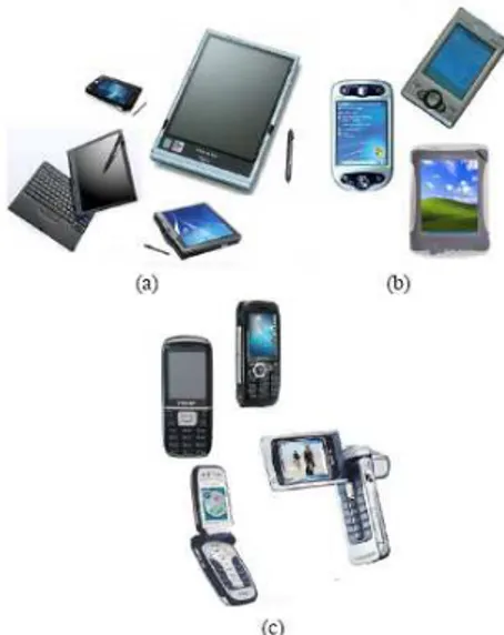
Monitor-based systems provide to the operator the opportunity to see virtual objects overlaid on real world without being equipped for many special glasses. In laboratories, these types of device permit to test quickly the experimental system. The operator is equipped with a camera. The acquired image is enhanced with the virtual object and then returned on the screen. There is a large number of this type of device. The most basic is obviously screen PC or Hand-held devices (for example, the magnifying glass approach). In addition, we find a new generation of Hand-held devices (figure 7) which are also used as display interfaces such as the Tablet PC, PDA (Personal Digital Assistants) and cellular phone. Among these devices, the tablet PC is the most powerful component; it has been used in several outdoor augmented reality projects such as MARS, ARCHEOGUIDE, and GEIST.
Figure 7: Handheld display devices: (a) Tables Pc (b) PDA (c) cellular phone
5.2.2 See-through AR-displays
Also called HMD (Head Mounted Display) (figure 9), this class of displays represented the most used devices in AR community. There are two different technologies: optical see-through and video see-through. Video see-through are equipped with two cameras through which the real environment is enhanced with virtual entities. In optical see-through, the display of the augmented scene is achieved using a system of mirrors that allows to overlay computer-generated graphics on the sight of the real scene.
Figure 8: Examples of Head Mounted Display
5.3 Software Architecture
In augmented reality, the developed software architectures aim at implementing an abstraction layer between the different technologies and algorithms (tracking, data fusion, etc.).
- DART: The Designer's Augmented Reality Toolkit [33] (Columbia University, 2003) is a tool for rapid development of AR applications. It enables designers to create informal content for experiments. Indeed, it offers a rapid prototyping to a wide public.
- COTERIE: Object-oriented Testbed for Exploratory Research in Interactive Environments [32] (Computer Graphics and User
Interfaces Lab, Columbia University, 1996-1999), is a tool for rapid prototyping of distributed virtual environment applications. It has been designed to support the creation of distributed virtual environments where multiple users can simultaneously interact with various display and input devices. COTERIE offers development tools for applications supporting multiple sensor technologies.
- STUDIERSTUBE: (University of Vienna, 1997) is one of the first architectures dedicated to augmented reality applications. It allows to explore the use of 3D interaction methods in a work space where many tasks are carried out simultaneously. This project was developed in order to find a powerful metaphor for 3D interaction similar to classic PC metaphor. - Tinmith: (University of South Australia, 1998) is a library of hierarchical objects similar to UNIX system file. It includes a set of classes that manage the data flow from various sensors, filtering and rendering process. Classes are developed in C++ language and use systems Callback and serialization of data streams using XML technology. A dataflow graph allows to manage communications between different objects.
- ARCS: Augmented Reality System Component, began in 2003 [11] (IBISC Laboratory, University of Evry) and allow to achieve in real time, a rapid prototyping of AR applications. In addition, ARCS facilitates interfacing heterogeneous technologies. ARCS is a component based programming system (developed in C++). It uses signals/slots scheme.
6
Outdoor augmented reality projects
In recent years, many outdoor AR projects have in military domain, civil engineering, cultural heritage, etc. In this section, we will present some of these projects.
6.1 Applications for military
Figure 9: BARS platform [23] tested by a soldier Many military conflicts are deployed into urban space. These new battlefields are complex because of restricted visibility, unfamiliar environment, lack of communications between the various troops and the difficulty of distinguishing between friends and foes. Developed in Naval Research Laboratory, (Washington, 2000), the project BARS "Battlefield
Augmented Reality System" [23] aims to propose a military navigation and localization system which allows soldiers to see relevant information such as inside building plans or position of snipers for example. Equipped with GPS coupled to inertial sensor (for localization) and see-through HMD (figure 9), the soldier can view data and interact with them using a mouse or voice commands.
6.2 Applications for Navigation
Figure 10: MARS platform [22]
Started in 1996 by the Computer Graphics and User Interfaces Lab (Columbia University), MARS project [22] (figure 10), acronym of “Mobile Augmented Reality System”, was one of the first outdoor AR projects. It aims to explore the synergy between augmented reality and mobile computing. The platform provided information on the environment where user is moving. This created a touring Machine. The system is composed of a laptop and a DGPS receiver to obtain a more accurate user’s position. Feiner & al. associated a differential corrector to GPS receiver. The orientation of point of view is determined using an inertial magnetometer. The user is also equipped with a tablet PC and a stylus to interact with the browser engine.
Other works were inspired by the MARS project such as Tinmith platform [43] (Wearable Computer Lab, University of Australia, 1998) (figure 11) and the collaborative mobile AR platform developed by Studierstube project [46] (Graz University of Technology, University of Vienna, 2004).
Figure 11: Tinmith platform [43]
Started in 2000, ARCHEOGUIDE project (Augmented Reality-based Cultural HEritage On-site GUIDE) [14] aims to develop new interactive methods for accessing to cultural heritage information. This system includes a laptop, a HMD, headphones, a microphone and a camera. The
system filter the information designed through user’s position and orientation.
Figure 12: 3D Greek temple viewed via ARCHEOGUIDE [14]
Moreover, the proposed interface allows choosing between several themes and media. ARCHEOGUIDE provides an opportunity to visualize the 3D reconstructed damaged site (see figure 12).
6.3 Applications for architecture and construction
UM-AR-GPSROVER [3] (Department of Civil and Environmental Engineering, University of Michigan) allows to view virtual models of construction in an urban environment (figure 13). The system is composed of a GPS receiver for position and an inertial sensor for orientation, a HMD, a camera and a laptop.
Figure 13: Example of augmented construction view [3]
6.4 Entrainment and Game applications
Figure 14: ARQuake game [42]
ARQuake [42] (see figure 14) represents one of the first game based on outdoor augmented reality paradigms. It is an adaptation of the popular game Quake. The aim of the project is to construct a game that run in a real environment and where player can move freely. The virtual objects are aligned with respect to player’s head position and orientation. The pose is estimated by the fusion of inertial sensor data and visual tracking method using ARToolKit Library. This platform uses Tinmith
architecture. Other interactive outdoor AR games have emerged, such as Game-City [7], Human Pacman [6] which is an adaptation of popular game Pacman.
6.5 Visualizing geo-referenced data
Using Tinmith architecture, ARVino platform allows to visualize viticulture GIS data. The system is composed of a laptop, a video, a GPS receiver for position and a magnetic sensor for orientation. It is placed on a rotating table mounted on a tripod.
Started in April 2006, the project Vidente [37] (collaboration between Institute of Computer Graphics and Vision (ICG) and GRINTEC GmbH) aims to develop a mobile augmented reality solution to visualize subsurface characteristics. Users will be equipped with a mini-Tablet PC coupled with camera and various heterogeneous sensors. From user’s localization, it is possible to visualize in real time 3D representation of network of cables and pipes hidden underground (see figure 15). The data were provided via a GIS (Geographic Information System). The project’s aim is to provide an additional tool to existing mobile GIS solutions, and contribute to an optimized processing for data access.
Figure 15: Vidente project [37]
7
Conclusion
Outdoors augmented reality presents several challenges on technological aspect (sensors, mobile terminals, etc) methodological aspect (3D localization techniques, generation of 3D environment, 3D visualization and interaction), as well as industrial aspect. The development of such systems requires solving several AR mobile scientific hard points: 3D localization in outdoor environment, visualization and 3D interaction via mobiles devices.
The survey presented in this paper has been conducted in RAXENV project. RAXENV (Outdoor Augmented Reality applied to environment sciences) aims to demonstrate the feasibility of outdoor augmented reality system dedicated to environment science and technology for the environment, both in terms of technology but also adoption by users. RAXENV is an exploratory project supported by ANR (the French National Research Agency), whose main goals are:
- To develop a 3D localization system using several sensors for virtual/real registration. This system should be robust to illumination conditions, occlusions, etc;
- To propose an acquisition and representation system of geo-referenced data; - To develop methods for representing subsurface objects (pipes, cavities, etc) in an augmented environment;
- To propose new 3D interaction methods;
Figure 16: Raxenv in urban scenario: Conceptuel view.
RAXENV differs from the conventional augmented reality approaches often used in the industry. It is dedicated to unfamiliar outdoor environments and based on Geographic Information Systems (GIS). Also, it explores ways to interact with data in mobility situation where the use of devices such as keyboard/mouse is impossible or inappropriate.
References
[1] . T. Auer, S. Brantner, A. Pinz: The integration of optical and magnetic tracking for multi-user augmented reality.
[2] . R. Azuma, B. Hoff, H. N. Iii, R. Sarfaty: A motion-stabilized outdoor augmented reality system. In VR ’99: Proceedings of the IEEE Virtual Reality, page 252, Washington, DC, USA, 1999. IEEE Computer Society. [3] . A. Behzadan, V. Kama: Visualization of construction
graphics in outdoor augmented reality. In Source Winter Simulation Conference, Proceedings of the 37th conference on winter simulation, page 1914˝U1920, Orlando, Florida, 2005.
[4] . E. Bier. Skitters and jacks: Interactive 3d positioning tools. In Workshop on Interactive 3D Graphics, pages 183–196. ACM, 1986.
[5] . M. Chen, S. J. Mountford, A. Sellen: A study in interactive 3-d rotation using 2-d control devices. In SIGGRAPH ’88: Proceedings of the 15th annual conference on Computer graphics and interactive techniques, pages 121–129, New York, NY, USA, 1988. ACM Press.
[6] . A. Cheok, K. Goh, W. Liu, F. Farbiz, S. Fong, S. Teo, Y. Li, X. Yang: Human pacman: a mobile, wide-area entertainment system based on physical, social, and ubiquitous computing. In Source Personal and Ubiquitous Computing archive Volume 8, Issue 2, London, UK, 2004. Springer.
[7] . A. Cheok, F. Wan, X. Yang, W. Weihua, L. Huang, M. Billinghurst, H. Kato: Game-city: a ubiquitous large area multi-interface mixed reality game space for wearable computers. In Sixth International Symposium on Wearable Computers, pages 156– 157, 2002. [8] . Y. Cho, J. Lee, U. Neumann: A multi-ring color
fiducial system and an intensity-invariant detection method for scalable fiducial tracking augmented reality. In IWAR, page 1998.
[9] . A. Comport, F. Marchand, F. Chaumette: A real-time tracker for markerless augmented reality. In ACM/IEEE Int. Symp. On Mixed and Augmented Reality, ISMAR’03, pages 36–45, Tokyo, Japan, October 2003. [10] . N. Cornelis, B. Leibe, K. Cornelis, L. V. Gool: 3d
city modeling using cognitive loops. In 3DPVT ’06: Proceedings of the Third International Symposium on 3D Data Processing, Visualization, and Transmission (3DPVT’06), pages 9–16, Washington, DC, USA, 2006. IEEE Computer Society.
[11] . J. Didier, S. Otmane, and M. Mallem: A component model for augmented/mixed reality applications with reconfigurable data-flow. In 8th International Conference on Virtual Reality (VRIC 2006), pages 243– 252, Laval (France), April 26-28 2006.
[12] . T. Drummond and R. Cipolla: Real-time tracking of complex structures for visual servoing. In Workshop on Vision Algorithms, pages 69–84, 1999.
[13] . D. Fallmana, A. Lund, M. Wiberg. Scrollpad: Tangible scrolling with mobile devices. In HICSS ’04: Proceedings of the Proceedings of the 37th Annual Hawaii International Conference on System Sciences (HICSS’04) - Track 9, page 90286.3, Washington, DC, USA, 2004. IEEE Computer Society.
[14] . T. Gleue and P. Daehne: Design and implementation of a mobile device for outdoor augmented reality in the archeoguide project. In Virtual Reality, Archaeology, and Cultural Heritage International Symposium, Glyfada, Nr Athens, Greece, 28-30 2001.
[15] . M. Hachet, J. Pouderoux, P. Guitton: A camera-based interface for interaction with mobile handheld
computers. In Proceedings ofI3D’05 - ACM
SIGGRAPH 2005 Symposium on Interactive 3D Graphics and Games, pages 65–71. ACM Press, 2005. [16] . M. Hachet, J. Pouderoux, F. Tyndiuk, P. Guitton:
"jump and refine" for rapid pointing on mobile phones. In CHI ’07 : Proceedings of the SIGCHI conference on Human factors in computing systems, pages 167–170, New York, NY, USA, 2007. ACM Press.
[17] . G. Hager and P. Belhumeur: Efficient region tracking with parametric models of geometry and illumination. IEEE Transactions on Pattern Analysis and Machine Intelligence, 20(10):1025–1039, 1998. [18] . M. Hancock, S. Carpendale, A. Cockburn: Shallow
depth 3d interaction: Design and evaluation of one-, two-, and three-touch techniques. In Proceedings of ACM CHI’2007 Conference on Human Factors in Computing Systems. San Jose, CA, 2007.
[19] . K. Hinckley, P. Baudisch, G. Ramos, F. Guimbretiere: Design and analysis of delimiters for selection-action pen gesture phrases in scriboli. In CHI ’05 : Proceedings of the SIGCHI conference on Human factors in computing systems, pages 451–460, New York, NY, USA, 2005. ACM Press.
[20] . W. Hoff, T. Lyon, K. Nguyen: Computer vision-based registration techniques for augmented reality. Volume 2904, pages 538–548. Proc. of Intelligent
Robots and Computer Vision XV, In Intelligent Systems and Advanced Manufacturing, SPIE„ Nov. 19-21 1996. [21] . D. Hoiem, A. Efros, M. Hebert. Automatic photo
pop-up. ACM SIGGRAPH 2005 / ACM Transactions on Graphics, 2005.
[22] . T. Hollerer, S. Feiner, T. Terauchi, G. Rashid, D. Hallaway. Exploring mars: Developing indoor and outdoor user interfaces to a mobile augmented reality system. Computers and Graphics, Elsevier Publishers, 23(6):779–785, December 1999.
[23] . S. Julier, Y. Baillot, M. Lanzagorta, D. Brown, L. Rosenblum. Bars: Battlefield augmented reality system. In NATO Symposium on Information Processing Techniques for Military Systems, Istanbul, Turkey, 9-11 October 2000.
[24] . F. Jurie and M. Dhome: Real time 3d template matching.
[25] . H. Kato and M. Billinghurst: Marker tracking and hmd calibration for a video-based augmented reality conferencing system. In IWAR ’99: Proceedings of the 2nd IEEE and ACM International Workshop on Augmented Reality, page 85, Washington, DC, USA, October 1999. IEEE Computer Society.
[26] . A. Khan, B. Komalo, J. Stam, G. Fitzmaurice, G. Kurtenbach: Hovercam: interactive 3d navigation for proximal object inspection. In I3D ’05: Proceedings of the 2005 symposium on Interactive 3D graphics and games, pages 73–80, New York, NY, USA, 2005. ACM Press.
[27] . G. King, W. Piekarski, B. Thomas. Arvino - outdoor augmented reality visualisation of viticulture GIS data. In Proceedings of the Fourth IEEE and ACM International Symposium on Mixed and Augmented Reality, OCT 2005.
[28] . D. Koller, G. Klinker, E. Rose, D. Breen, R. Whitaker, and M. Tuceryan. Real-time vision-based camera tracking for augmented reality applications. In D. Thalmann, editor, ACMSymposium on Virtual Reality Software and Technology, New York, NY, 1997. ACM Press.
[29] . F. Lafarge, X. Descombes, J. Zerubia, M.
Pierrot-Deseilligny. Modèle paramétrique pour la
reconstruction automatique en 3d de zones urbaines denses à partir d’images satellitaires haute résolution.
Revue Française de Photogrammétrie et de
Télédétection (SFPT), 180 :4–12, 2005.
[30] . V. Lepetit, L. Vacchetti, P. F. D. Thalmann: Fully automated and stable registration for augmented reality applications. In ISMAR ’03 : Proceedings of the The 2nd IEEE and ACM International Symposium on Mixed and Augmented Reality, page 93, Washington, DC, USA, 2003. IEEE Computer Society.
[31] . B. Lucas and T. Kanade: An iterative image registration technique with an application to stereo vision. In IJCAI81, pages 674–679, 1981.
[32] . B. MacIntyre and S. Feiner: Language-level support for exploratory programming of distributed virtual environments. In ACM Symp. On User Interface Software and Technology, pages 83–95, Seattle, WA, November 6-8 1996.
[33] . [33] B. MacIntyre, M. Gandy, S. Dow, J. Bolter. Dart: A toolkit for rapid design exploration of augmented reality experiences. In User Interface Software and Technology, Sante Fe, New Mexico, 2004.
[34] . J. Mackinlay, S. Card, G. Robertson: Rapid controlled movement through a virtual 3d workspace. In
Proceedings of the 17th annual conference on Computer graphics and interactive techniques, pages 171–176. ACM Press New York, NY, USA, 1990.
[35] . J.-E. Marvie: Visualisation Interactive
d’Environnements Virtuels Complexes à travers des Réseaux et sur des Machines à Performances Variables. PhD thesis, INSA, de Rennes, France, 2004.
[36] . L. Masson, M. Dhome, F. Jurie.: Contour/texture approach for visual tracking. In Scandinavian Conference on Image Analysis, 2003.
[37] . E. Mendez, D. Kalkofen, D. Schmalstieg: Interactive context driven visualisation tools for augmented reality. In International Symposium of Mixed and Augmented Reality, pages 209–216, Santa Barbara, California, USA, October 22-25.
[38] . P. Müller, P.Wonka, S. Haegler, A. Ulmer, L. V. Gool: Procedural modeling of buildings. 25(3):614–623, 2006.
[39] . P.Müller, G. Zeng, P.Wonka, and L. V. Gool: Image-based procedural modeling of facades. 26(3), 2007.
[40] . G. Nielson and D. O. Jr: Direct manipulation techniques for 3d objects using 2d locator devices. In SI3D ’86: Proceedings of the 1986 workshop on Interactive 3D graphics, pages 175–182, New York, NY, USA, 1987. ACM Press.
[41] . W. Piekarski, B. Avery, B. Thomas, P. Malbezin: Hybrid indoor and outdoor tracking for mobile 3d mixed reality. Ismar, 00:266, 2003.
[42] . W. Piekarski and B. Thomas: Arquake: the outdoor augmented reality gaming system. Communications of the ACM, 45(1):36–38, 2002.
[43] . W. Piekarski, B. Thomas, and B. H: Tinmith-evo5 - architecture for supporting mobile augmented reality environments. In 2nd Int’l Symposium on Augmented Reality, pages 177–178, New York, October 2001. [44] . J. Pouderoux : Création semi-automatique de
modèles numériques de terrain - Visualisation et interaction du terminaux mobiles communicants. PhD thesis, Université Bordeaux 1, France, 2007.
[45] . M. Pressigout and E. Marchand. Real-time 3d model-based tracking: Combining edge and texture information. In IEEE Int. Conf. on Robotics and Automation, ICRA’06, pages 2726–2731, Orlando, Florida, May 2006.
[46] . G. Reitmayr and D. Schmalstieg. Collaborative
augmented reality for outdoor navigation and
information browsing. Technical Report TR- 188-2-2003-28, 2003.
[47] . J. Rekimoto and K. Nagao. The world through the computer: Computer augmented interaction with real world environments. In symposium User Interface Software and Technology, 1995.
[48] . M. Ribo, P. Lang, H. Ganster, M. Brandner, C. Stock, and A. Pinz. Hybrid tracking for outdoor augmented reality applications. IEEE Comput. Graph. Appl., 22(6):54–63, 2002.
[49] . D. Robbins, E. Cutrell, R. Sarin, and E. Horvitz. Zonezoom: map navigation for smartphones with recursive view segmentation. In AVI ’04: Proceedings of the working conference on advanced visual interfaces, pages 231–234, New York, NY, USA, 2004. ACM Press.
[50] . G. Simon, A. Fitzgibbon, and A. Zisserman. Markerless tracking using planar structures in the scene. In Proc. International Symposium on Augmented Reality, pages 120–128, October 2000.
[51] . A. State, G. Hirota, D. Chen, W. Garrett, and M. Livingston. Superior augmented reality registration by integrating landmark tracking and magnetic tracking.
Computer Graphics, 30(Annual Conference
Series):429–438, 1996.
[52] . D. Stricker and T. Kettenbach. Real-time and markerless vision-based tracking for outdoor augmented reality applications. Ismar, 00:189, 2001.
[53] . L. Vacchetti, V. Lepetit, and P. Fua. Combining edge and texture information for real-time accurate 3d camera tracking. In ISMAR ’04: Proceedings of the Third IEEE and ACM International Symposium on Mixed and Augmented Reality (ISMAR’04), pages 48– 57, Washington, DC, USA, 2004. IEEE Computer Society.
[54] . C. Ware and S. Osborne. Exploration and virtual
camera control in virtual three dimensional
environments. In Proceedings of the 1990 symposium on Interactive 3D graphics, pages 175–183. ACM Press New York, NY, USA, 1990.
[55] . H.Wuest, F. Vial, and D. Stricker. Adaptive line tracking with multiple hypotheses for augmented reality. In ISMAR ’05 : Proceedings of the Fourth IEEE and ACM International Symposium on Mixed and Augmented Reality, pages 62–69, Washington, DC, USA, 2005. IEEE Computer Society.
[56] . [56] K. Yee. Peephole displays: pen interaction on spatially aware handheld computers. In CHI ’03 : Proceedings of the SIGCHI conference on Human factors in computing systems, pages 1–8, New York, NY, USA, 2003. ACM Press.
[57] . R. Zeleznik and A. Forsberg. Unicam - 2d gestural camera controls for 3d environments. In Proceedings of Symposium on Interactive 3D Graphics, pages 169–173, 1999.
[58] . R. Zeleznik, A. Forsberg, and P. Strauss. Two pointer input for 3d interaction. In Proceedings of the 1997 symposium on Interactive 3D graphics, 1997.
![Figure 2: Examples of 3D models of urban environment: (a) FastBuilder (b) CityEngine Hoeim [21] uses image-based method for the reconstruction of a simple model](https://thumb-eu.123doks.com/thumbv2/123doknet/14365100.503378/4.892.130.420.347.540/figure-examples-models-environment-fastbuilder-cityengine-hoeim-reconstruction.webp)
![Figure 4: Jump and Refine [16]](https://thumb-eu.123doks.com/thumbv2/123doknet/14365100.503378/5.892.532.753.855.1001/figure-jump-and-refine.webp)

![Figure 10: MARS platform [22]](https://thumb-eu.123doks.com/thumbv2/123doknet/14365100.503378/8.892.487.798.152.313/figure-mars-platform.webp)
![Figure 15: Vidente project [37]](https://thumb-eu.123doks.com/thumbv2/123doknet/14365100.503378/9.892.492.799.258.505/figure-vidente-project.webp)
![Probing the Local Magnetic Structure of the [FeIII(Tp)(CN)3]- Building Block Via Solid-State NMR Spectroscopy, Polarized Neutron Diffraction, and First-Principle Calculations](data:image/gif;base64,R0lGODlhAQABAIAAAP///wAAACH5BAEAAAAALAAAAAABAAEAAAICRAEAOw==)