HAL Id: hal-00299112
https://hal.archives-ouvertes.fr/hal-00299112
Submitted on 3 Jan 2005
HAL is a multi-disciplinary open access
archive for the deposit and dissemination of
sci-entific research documents, whether they are
pub-lished or not. The documents may come from
teaching and research institutions in France or
abroad, or from public or private research centers.
L’archive ouverte pluridisciplinaire HAL, est
destinée au dépôt et à la diffusion de documents
scientifiques de niveau recherche, publiés ou non,
émanant des établissements d’enseignement et de
recherche français ou étrangers, des laboratoires
publics ou privés.
The influence of the geological setting on the
morphogenetic evolution of the Tremiti Archipelago
(Apulia, Southeastern Italy)
G. F. Andriani, N. Walsh, R. Pagliarulo
To cite this version:
G. F. Andriani, N. Walsh, R. Pagliarulo. The influence of the geological setting on the morphogenetic
evolution of the Tremiti Archipelago (Apulia, Southeastern Italy). Natural Hazards and Earth System
Science, Copernicus Publications on behalf of the European Geosciences Union, 2005, 5 (1), pp.29-41.
�hal-00299112�
European Geosciences Union
© 2005 Author(s). This work is licensed under a Creative Commons License.
and Earth
System Sciences
The influence of the geological setting on the morphogenetic
evolution of the Tremiti Archipelago (Apulia, Southeastern Italy)
G. F. Andriani1, N. Walsh1, and R. Pagliarulo2
1Dipartimento di Geologia e Geofisica, Universit`a degli studi di Bari, Italy 2National Research Council – IRPI, Bari, Italy
Received: 6 September 2004 – Revised: 29 November 2004 – Accepted: 2 December 2004 – Published: 3 January 2005
Part of Special Issue “Natural and anthropogenic hazards in karst areas”
Abstract. The Tremiti Archipelago (Southern Adriatic Sea), also called Insulae Diomedae from the name of the Greek hero who first landed there, is an area of high landscape and historical value. It is severely affected by significant geomorphologic processes dominated by mass movements along the coast that constitute the most important and unpre-dictable natural hazard for the population and cultural her-itage. Coastal erosion is favoured by the peculiar geological and structural setting, seismic activity, weathering, develop-ment of karst processes, and wave action.
The present paper reports on descriptive and qualitative evaluation of the factors controlling landslides and coastline changes based on medium-term in situ observation, detailed surface surveys at selected locations since 1995, and historic and bibliographic data.
The Tremiti Archipelago is part of an active seismic area characterised by a shear zone separating two segments of the Adriatic microplate that have shown different behaviour and roll back rates in the subduction underneath the Apennines since middle Pleistocene.
Although coastal morphology can be basically considered to be the result of wave action, the continual action of sub-aerial processes contributes effectively to the mechanism of shoreline degradation. Weathering mainly affects the marly calcisiltites and calcilutites of the Cretaccio Fm. and the fri-able and low cemented calcarenites and biomicrites of the San Nicola Fm. The cliffs are characterised by different types of failure such as lateral spreads, secondary topples, rock falls and slides. At the Isle of San Nicola, landslides are controlled by the contrast in competence, shear strength and stiffness between the Pliocene re-crystallised dolomitic cal-carenites and calcisiltites and the Miocene marly calcilutites and calcisiltites. At the Isles of San Domino and Caprara rock falls are attributed to the undercutting of waves at the base of the cliffs.
Correspondence to: G. F. Andriani
1 Introduction
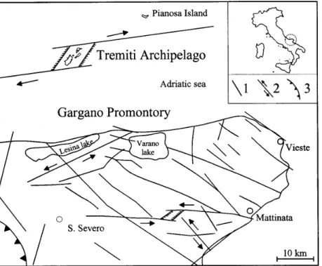
The Tremiti Archipelago (southern Italy), about 10 miles north of the Gargano Promontory coast (Fig. 1), is made up of four islands – San Domino (∼=2.0 km2), San Nicola (∼=0.50 km2), Caprara (∼=0.45 km2), Cretaccio (∼=0.04 km2)1. It is located at the northern margin of the Apulian platform, along a right-lateral transfer zone separat-ing the Adriatic microplate in two sub-plates with different geodynamic behaviour (Mongelli et al., 1994).
The geological setting of the Tremiti Archipelago (Fig. 2) has been documented by Tellini (1890), Bassani (1907), Squinabol (1908), Checchia Rispoli (1926, 1928), Baldacci (1953), Pasa (1953), Selli (1971), Pampaloni (1988), An-driani and Guerricchio (1996), Cotecchia et al. (1995) and Cresta et al. (1999). It is characterised by three pre-Neogene marine formations outcropping mainly in the Isles of San Domino and Caprara and two Neogene marine formations in the Isles of Cretaccio and San Nicola. Middle to late Pleistocene continental deposits (conglomerates, loess and calcareous crust) lie on the marine formations. More re-cently high-resolution cyclostratigraphic (astrochronological calibration), biostratigraphic and palaecological studies have been carried out on the Miocene sediments of the Tremiti Islands, specifically on the middle Serravallian-basal Torto-nian section of the Cretaccio Fm. outcropping at the Isle of San Nicola (Lirer et al., 2002; Foresi et al., 2002; Russo et al., 2002; Dall’Antonia, 2002; 2003; Sprovieri et al., 2002).
The coastal morphology mainly characterised by high cliffs (up to about 60 m high) and low and flat coasts is of particular interest. In some places, the coastline is broken by caps, pronounced inlets, coves and small bays, arches and stacks, and sea caves continually widened by the wave ac-tion. Selective erosive phenomena and landsliding along the
1The Islet of Pianosa (∼=0.1 km2), about 20 miles north of the
Gargano coast, belongs to the Tremiti municipal administration as well. There are outcrops of very finely crystalline Eocene dolo-stones and limedolo-stones here on which Pleistocene reddish conglo-merates and calcareous marls lie.
30 G. F. Andriani et al.: The morphogenetic evolution of the Tremiti Archipelago
Fig. 1. Schematic structural map of the Tremiti Archipelago and Gargano Promontory. The circle in
the box at the top right represents the area of the tectonic scheme shown. Explanation: 1) Main
sub-vertical faults with a prevailing dip-slip movement; 2) Main sub-sub-vertical faults with a prevailing
strike-slip movement; 3) Apennine front.
Fig. 1. Schematic structural map of the Tremiti Archipelago and Gargano Promontory. The circle in the box at the top right represents the
area of the tectonic scheme shown.
Explanation: 1) Main sub-vertical faults with a prevailing dip-slip movement; 2) Main sub-vertical faults with a prevailing strike-slip move-ment; 3) Apennine front.
coastline are widespread in the isles but assume significant importance in the high cliff sectors where weak and porous marly calcisiltites and calcilutites are overlain by stronger calcareous and dolomitic rocks (San Nicola Isle).
The climate in the Tremiti Archipelago is typically Mediterranean, characterized by an annual temperature trend consisting of mild or absent winters and hot, dry summers. The temperature regime is characterised by minimum values (mean minimum of 8.4◦C) registered in January and
maxi-mum values in August (mean maximaxi-mum 29.6◦C) with peaks that occasionally reach up to 35◦. The mean annual tempera-ture is 17.7◦C. The Tremiti islands fall within the Eumediter-ranean rainfall typology. Rainfall is concentrated, above all, in winter and autumn, with an annual mean of 476.1 mm dis-tributed in 53 rainy days. The mean seasonal division of rainfall is: 156.7 mm (32.9%) in winter, 94 mm (19.8%) in spring, 74 mm (15.5%) in summer and 151.4 mm (31.8%) in autumn. The prevailing winds come from the 2nd and 4th quadrant; calm sea conditions are prevalent in the summer period whereas rough seas and storms are more frequent in autumn–winter.
Starting from medium-term in situ observations, de-tailed surface surveys at selected locations in the period 1995–2002, and historic and bibliographic data (archival ter-restrial photographs taken since the 1960’s and scientific pa-pers reported in references), this paper describes the main factors influencing the geomorphologic processes affecting the Tremiti islands. In particular, a detailed overview on
the geological, geostructural and morphologic features of the Archipelago is provided, as a preliminary basis for future landslide hazard analysis aimed at safeguarding the natural beauty of the coastline and the archaeological sites. The study resulted in a better comprehension of the principal and potential coastal erosional processes and of the landslide mechanisms in a seismically active area.
2 Geostructural setting and seismicity
The Tremiti Archipelago belongs to the Adria microplate (Lort, 1971), as their location is at the northern margin of the Apulian platform (Gambini and Tozzi, 1996), representing the top of a NE–SW elongated structural high located along an E–W to NE–SW regional strike-slip fault zone (Favali et al., 1993). This hypothesis is supported by interpretations of marine seismic reflection data (Finetti et al., 1987). Previous workers, using a micro- and meso-structural approach, have interpreted the Tremiti islands as a pushed up ridge within a E–W dextral strike slip fault system associated with the regional tectonic system of the Gargano Promontory (Mon-tone and Funiciello, 1989). Selli (1971) considers the Tremiti islands a gentle (10◦–20◦) SE-dipping slightly folded mon-ocline structure, characterised, above all, by NW–SE and E–W distensive and sub-vertical faults. Recently, using a data set consisting of exploration wells and reflection seismic profiles, Argnani et al. (1994) illustrate the general folded
Fig. 2. Geological sketch of the Tremiti Archipelago. Explanation: 1) Continental deposits (Pleistocene-Holocene); 2) Recrystallised and fractured dolomitic calcarenites (middle- late Pliocene); 3) Marly calcisiltites and calcilutites (Aquitanian-Tortonian); 4) Biocalcarenites and biostromal limestones (middle-late Eocene); 5) Fine grained dolomites (early Eocene); 6) Fine grained calcitic dolomites and biocalcarenites (Thanetian- Ilerdian); 7) Bedding attitude; 8) Fault; 9) Geostructural measurement station.
Fig. 2. Geological sketch of the Tremiti Archipelago.
Explanation: 1) Continental deposits (Pleistocene-Holocene); 2) Recrystallised and fractured dolomitic calcarenites (middle-late Pliocene); 3) Marly calcisiltites and calcilutites (Aquitanian-Tortonian); 4) Biocalcarenites and biostromal limestones (middle-late Eocene); 5) Fine grained dolomites (early Eocene); 6) Fine grained calcitic dolomites and biocalcarenites (Thanetian- Ilerdian); 7) Bedding attitude; 8) Fault; 9) Geostructural measurement station.
appearance of the so-called TDB (Tremiti Deformation Belt). The TDB trends NE–SW and is asymmetric with a steeper southern flank.
Field evidence, such as E–W trending right lateral transtension faults cross-cutting Pliocene and late Miocene formations (Funiciello et al., 1988), sets of en-´echelon R shears and horizontal slickensides in the San Domino Fm. (Doglioni et al., 1996), support a right-lateral move-ment along the E–W Tremiti alignmove-ment to the North of the Gargano Promontory (Doglioni et al., 1994). It is an active E–W trending right lateral transtensional fault interpreted as a boundary between two blocks of the Adria microplate with different thickness and tectonic regimes (Calcagnile and Panza, 1981; Mosetti and Mosetti, 1984, Favali et al. 1990; 1993; Console et al., 1993; Mongelli et al., 1994). Indeed, since the middle Pleistocene period, the southern Adriatic block (Apulia foreland and Bradanic foredeep), made up of a continental lithosphere about 110 km thick, began to up-lift (∼=0.5 mm/yr) while the northern Adriatic block (cen-tral Adriatic sea), with a thinner continental lithosphere of about 70 km, was characterised by a high subsidence rate (greater than 1 mm/yr) (Ciaranfi et al., 1983; Suhadolc and Panza, 1989). In the west dipping subduction of the Adria
microplate associated with the east-ward migration of the Apenninic arc, the different thickness and subduction style of the two blocks seem to have controlled the variable degree of flexure of the lithosphere, its asthenospheric penetration rate, the presence of an elastic bulge in the southern Adriatic block and a faster hinge roll-back of the northern Adriatic block (Mongelli et al., 1994).
Just like the Gargano, its neighbouring offshore area, Tremiti are also well known as a seismic active zone. Since 1600 A.D., the Gargano region has been affected by nu-merous seismic events. Most of these earthquakes occurred offshore, therefore their location, especially for the oldest events, is quite questionable and is based on a macroseismic approach (Tinti and Piatanesi, 1996). A detailed analysis of the Italian seismic catalogues (Postpischl, 1985; ING, 1991) shows the occurrence of seismic activity off the Gargano Promontory. The most ancient recorded tsunami dates back to 1627, triggered by an earthquake with epicentre located in the southern part of the Gargano Promontory. In the is-lands, the seismic intensity estimated was degree VII of the MCS scale. Afterwards, the Tremiti Islands were hit by seis-mic events of degree VII of the MCS scale in 1889 and 1902. Another four seismic sequences were recorded between 1906
32 G. F. Andriani et al.: The morphogenetic evolution of the Tremiti Archipelago
and 1909. The most intense of these occurred in 1908 with maximum intensity of degree VI of the MCS scale (Cotec-chia et al., 1995).
Recently, off the Gargano Promontory three impor-tant seismic sequences occurred between 1986 and 1990. In 1986, the first seismic sequence (body wave magni-tude, mb=4.2) was recorded 50 km north of the Tremiti
Archipelago and, later, in 1988, a second one NNE of the Gargano Promontory (mb=5.3). In 1989 another
earth-quake occurred (mb=4.7) with the epicentre at the Tremiti
Archipelago (Favali et al., 1993). These sequences were recorded and relocated using data collected by the new ian Telemetered Seismic Network (ITSN) and by other Ital-ian, Albanian and Yugoslavian seismic stations (Console et al., 1993).
3 Geological setting
The Tremiti Archipelago consists of a discontinuous se-quence of marine sediments, ranging from late Paleocene-early Eocene to middle-late Pliocene, overlain by late Pleistocene and Holocene discontinuous continental deposits (Selli, 1971). At the Isle of San Domino, in proximity to the “Bue Marino” cave, the older geologic unit, the Bue Marino Fm., outcrops along a steep scarp slope, which is very un-stable due to the continual recession of the cliff. The lower member is made up of idiotopic medium cristalline calcitic dolomites in layers of 50–200 mm, whitish and grey-greenish in colour. The upper member contains packstone dolomitic biocalcarenites, locally recrystallized, on which whitish fine dolomitic calcilutites lie. The rock fabric and its fossil con-tent are typical of shallow warm sea, in a calm and pro-tected environment (back reef lagoon) . The thickness of the formation is about 60 m. The geological age of the Bue Marino Fm. is Thanetian-Ilerdian (Selli, 1971). At the base of the same cliff at “Ripa dei Falconi” not far from the “Bue Marino” cave, Cresta et al. (1999) found two conglomer-ate levels, some decimetres thick, which contain micritized clasts with planktonic foraminifera of Turonian age. Other Authors (Mosetti and Mosetti, 1984) describe a stratigraphic succession outcropping in the SW part of the Isle of Caprara consisting of white and well stratified limestones with Radio-laria, overlain by Rudist limestones alternating with calcare-ous breccias, marly limestones and white friable limestones. In the vicinity of “Cala Sorrentino” (Caprara Isle), Tellini (1890) described a succession of subsaccharoid dolomites containing flint nodules just above the sea level, which were dated to the Neocomian by analogy of lithologic facies with that of Cretaceous strata outcropping at the Gargano Promon-tory.
The transgessive Caprara Fm. rests on the Bue Marino Fm. It consists of grey-greenish and yellowish very finely crys-talline dolomites, idiotopic in texture, well stratified (about 200 mm) and strongly deformed by slumping. At the Isle of Caprara, the lower member of the formation with flint nodules and lenses crops out between “Cala Sorrentino” and
“Cala dei Turchi” and, with a 25 m thick outcrop, between “Cala del Caff`e” and the lighthouse. Further outcrops are near the lighthouse of the Isle of San Domino (upper mem-ber), with a maximum thickness of 20 m. The formation shows the features of a bacinal environment and is attributed to early Eocene on the basis of the stratigraphic relation with the adjacent formations (Selli, 1971).
A continuity of sedimentation characterised the contact between the Caprara Fm. and the San Domino Fm., which outcrops widely at San Domino, Caprara and Cretaccio Isles. At Caprara, along the cliff between “Cala del Caff`e” and the lighthouse, it is possible to observe this contact. Here the lower member of the San Domino Fm. consists of yellow-greenish xenotopic medium crystalline doloarenites on which whitish diffusely recrystallised dolomitic calcaren-ites lie. At San Domino, to the S of the small tourist port (between “Grotta del Sale” and “Cala delle Arene”) and be-tween “Architiello” and “Punta Diamante”, the upper mem-ber of the formation is visible. It is composed of whitish Nummulites biocalcarenites and biocalcilutites, dolomitized at the basal levels, on which biostromal banks of whitish bio-calcilutites (biostromal limestones), brecciated at the upper levels, rest. The total thickness of the formation is about 200 m. The sedimentation of the lower member occurred in a high energy hydrodynamic environment while the up-per member occurred in a reef environment. The biostromal limestones are dated to the late Eocene (Selli, 1971).
The San Domino Fm. is overlain along a transgressive sur-face by the Cretaccio Fm., which is the most widespread unit in the Isles. The stratigraphic contact between the two formations can be observed on the eastern cliffs of San Domino (“Cala Matano”, “Cala Elefante”, “Punta dello Spido”, “Punta della Toppa”), at SSE of Caprara and in the western and northern zones of Cretaccio (Fig. 3). This in-terface is very irregular because of the intense karstification of the upper part of the Eocene unit occurring before the Miocene transgression. Sinkholes and karst pits with infilling of loose Miocene lithofacies consisting of dolomitic sands with coarse glauconite crystals are observable at San Domino (“Cala dell’Elefante”, “Cala delle Arene”). The lower mem-ber (up to 5 m thick) of the Miocene succession is rep-resented by well stratified (50–200 mm) yellow-greenwish and yellow-reddish glauconitic laminate doloarenites, char-acterised in texture by a hypidiotopic mosaic of dolomite crystals (from very finely to finely cristalline), coarse glau-conite crystals (about 20% of the total), fine quartz, mica, and carbonate clasts, phosphatic coprolites, ichtyodontolithes and few littoral benthic foraminifers (Bassani, 1907; Selli, 1971; Andriani and Guerricchio, 1996). Radiometric analy-sis with the87Rb/86Sr method on the glauconite crystals in-dicate Aquitanian age (Cresta et al., 1999). On the doloaren-ites, yellowish glauconitic biocalcilutites are followed first by marly biocalcilutites, then by yellow-whitish fossilif-erous marls, yellow-whitish and occasionally greyish cal-cisiltites and yellowish marly calcal-cisiltites containing fine yel-low limonite clasts. Stratification (between 200 and 400 mm in thickness) is indicated by clear bedding planes dipping,
Fig. 3. The Islet of Cretaccio. Stratigraphic contact (indicated by the red lines) between the
outcropping formations.
San Domino Fm. Cretaccio Fm. Quaternary Deposits WNW SSEFig. 3. The Islet of Cretaccio. Stratigraphic contact (indicated by the red lines) between the outcropping formations.
principally, SE ranging from 40◦to 20◦from the bottom to
the top. The age of the marly level can be referred to Bur-digalian (Cresta et al., 1999). In the northern part of the Isle of Cretaccio, the lower member of the formation shows soft-sediment deformation structures, probably due to liquefac-tion phenomena triggered by a seismic shack (seismites). At San Nicola Isle, the highest part of the formation is dated early Tortonian (Selli, 1971). The total tickness of the for-mation is about 150 m. The fossil content and the textural analyses show that for the lower part outcropping at Cre-taccio, Caprara and San Domino Isles, the sedimentation is typical of high energy littoral and shallow water environ-ment, while the medium and upper part outcropping along the coastal cliffs, are of neritic and open marine environment. The textural and sedimentological characters of this forma-tion show a great similarity to some sedimentary successions of the Salento area (southeastern Apulia) belonging to the Pietra Leccese Formation (Miocene).
The Cretaccio Fm. is overlain by the San Nicola Fm. along a transgressive surface. There is an angular discordance of about 10◦ between them, as the second one dips between 5 and 10◦SE indicated in the mid-lower part of the forma-tion by the alternaforma-tion of packed and friable levels as well as by lamination bands. The San Nicola Fm. outcrops only at San Nicola Isle and is about 35 m thick. At the contact with the underlying formation, it consists of hard recrys-tallised and fractured dolomitic calcarenites. This is followed upwards by white-greyish wackestone dolomitic calcisiltites and friable biomicrites on which whitish-yellow packstone dolomitic biocalcarenites, covered by re-precipitated calcite lie. The succession, overall brecciated and obscurely bedded, ends with a whitish-yellow calcareous travertinoid crust of ir-regular thickness, reaching 0.5 m at the most. The crust, ac-cording to Selli (1971), comes from the decalcification of the overlying loess deposits, now removed by erosion. Accord-ing to Cotecchia et al. (1995) on the other hand, the crusts are classified as caliche, resulting from capillary action of carbonate solution rising to the surface in environments char-acterised by hot temperatures and low rainfall. Based on the fossil content, the epoch can be referred to the middle-late
Pliocene. The sedimentation environment is typical of lit-toral areas, characterised by frequent variations of sea level.
Quaternary deposits of continental origin, consisting of breccias and conglomerates, marly limestone and loess are to be found on all the isles in the Archipelago. In partic-ular the complete succession of continental deposits of the upper Pleistocene and of the Holocene can be seen on the Isle of San Domino, between “Grotta del Sale” and “Grotta delle Viole” and between “Cala Tramontana” and “Cala degli Inglesi”. At the base there are well cemented conglomerates with reddish sandy-silty matrix and 10 to 100 mm clasts from the Eocene formation. The conglomerates are followed by an almost 2 m thick marly limestone and red marls horizon, which is overlain by 10 m thick deposit of eolian quarzose calcarenites with levels of red clays (red loess) and whitish-yellow clays. Cross-bedded whitish-yellow-orange eolian quartzose sands (yellow loess), with thickness of 6 m, follow upward. The succession ends with brownish-red and blackish loess containing subangular quartz clasts. The eolian deposits are interbedded by carbonate crusts. Conglomerates with sandy-silty matrix outcrop at 20 m a.s.l. even on the scarp slope near the tourist port of San Nicola and overlie the marly calcilu-tites along an irregular surface.
4 Morphology and mesostructural features
Morphologic features of the Tremiti Archipelago are con-trolled both by erosional processes and structural setting, the latter strongly related to the geodynamic history of the area at the regional scale. On the whole, the Tremiti Archipelago is characterised by a slightly rough morphology with hilly reliefs presenting steep slopes and subtabular top gently SE dipping (10◦–20◦), following the monoclinal structure of the Cenozoic formations. Exceptions are due to the presence of slight anticlinal structures often dislocated by faults with lit-tle vertical displacement, the most important of which can be seen in the southwestern area of the Isle of San Domino just N of “Poggio del Romito”, the highest hillock (116 m) in the Tremiti Islands.
34 G. F. Andriani et al.: The morphogenetic evolution of the Tremiti Archipelago
Fig. 4. “Architiello”, a sea arch in the N part of the “Caprara” isle.
Fig. 4. “Architiello”, a sea arch in the N part of the “Caprara” isle.
The coastal morphology results from the combined action of Quaternary tectonics, and the erosion by sea waves, and its evolution is closely correlated with lithology of outcropping rocks, weathering and karst processes, and the development of mass movements. Coastal morphology consists of high rocky cliffs (up to 60 m, at San Nicola Isle) and low-relief flat coasts with gently dipping convex slopes. The rocky cliffs show steep plunging cliffs with a vertical, and in places overhanging face where Eocene and Pliocene strata crop out, while slopes dipping between 50◦ and 75◦characterise the cliffs cut in the Miocene strata at San Nicola Isle. The flat coast sectors are slightly indented and contain large coves (“Cala degli Inglesi” and “Cala Tramontana” at San Domino Isle). Only one sandy beach, about 2000 m2, is located at San Domino Isle (“Cala delle Arene”) directly opposite San Nicola Isle, whereas an eroding pocket beach, formed of loose cobbles is observed at “Cala Sorrentino” (Caprara Isle).
Where Paleogene strata crop out, the coastline is more ar-ticulated in caps and promontories (“Scoglio dell’Elefante”, “Punta del Diavolo”, “Punta del Coccodrillo”, “Punta Dia-mante” at San Domino Isle; “Punta del Cimitero” at San Nicola Isle; “Punta Romito” at Caprara Isle), inlets, small bays (“Cala dello Spido”, “Cala Matano” at San Domino Isle; “Cala dei Turchi” at Caprara Isle), sea caves (“Grotta del Bue Marino”, “Grotta delle Rondinelle”, “Grotta delle Viole”, “Grotta del Sale”), arches (“Architiello” at San Domino Isle, “Architiello” at Caprara Isle) (Fig. 4) and stacks (“i Pagliai” at San Domino Isle, “la Vecchia” at Cretaccio Islet, “gli Scoglietti” at Caprara Isle). Inlets, small bays and sea caves are located along structural weaknesses, typically along faults. Sea caves, at sea level and with limited develop-ment are not hydrogeologically active. They lack calcite de-posits or speleothems and seem to have been formed mainly
by the hydraulic action of waves and pneumatic action of trapped air, rather than by hyper-karst processes (Delle Rose and Parise, 2003), although the contribution of the mixing between infiltration rainwater and sea water that may have increased solubility of the rock mass and crack aperture can-not be excluded. Today, the Tremiti Archipelago lacks water resources (springs, groundwater and streams) and there is no evidence of a karst drainage system in the caves vis-ited. Arches and stacks are also associated with the main faults. They represent erosional features formed by wave ac-tion on either one or both sides of sea caves. Between “Punta Diamante” and “Cala degli Schiavoni” at San Domino Isle, “I Pagliai”, a series of large aligned stacks formed along a right-lateral NW-SE strike-slip fault, are cut in steep cliffs of fine grained and resistant Eocene dolomitic limestones. Stacks are not always produced by the collapse of sea arches. “La Vecchia”, at Cretaccio Islet, is a stack (Fig. 5), now al-most completely eroded, which did not develop from an arch because of the friable stratigraphic units outcropping here, but was produced by wave action and subaerial processes along a zone of accelerated erosion (a structural weakness). Notches are not very deep and narrow and cut the cliff foot between mean low tide and high tide, respectively, at the southwestern and western side of San Domino and Caprara Isles, where the coastline is higher and steeper because of the 10◦–20◦SE monoclinal setting of the Tremiti Archipelago.
The coastline is not very articulated and lacks large sea caves, inlets and other erosional features, where Miocene and Pliocene formations outcrop, because of the rapid recession of cliffs, in spite of the presence of discontinuity systems favourable for erosional landform development even in sec-tors directly exposed to incoming waves. The small “del Fer-raio” cave at San Nicola Isle, two very small caves in the
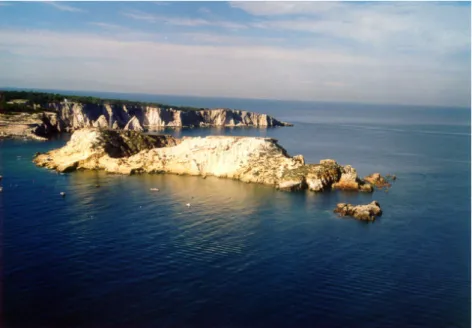
Fig. 5. In foreground Cretaccio Islet. At the bottom right, note the “la Vecchia” stack almost completely eroded. At the top left, “i Pagliai”. These are stacks formed by the collapse of the vault of arches (San Domino Isle).
Fig. 5. In foreground Cretaccio Islet. At the bottom right, note the “la Vecchia” stack almost completely eroded. At the top left, “i Pagliai”.
These are stacks formed by the collapse of the vault of arches (San Domino Isle).
Fig. 6. Karst pit and weathering shapes in the upper member of the San Nicola Formation.
Fig. 6. Karst pit and weathering shapes in the upper member of the San Nicola Formation.N part of Cretaccio and an inlet that divides the Islet of Cre-taccio into two branches are an exception. Large rock scars and accumulations of debris at cliff feet bear witness to the importance of mass movement along the coastline, above all at San Nicola Isle.
Karst action, which developed in various phases during the regression periods (Oligocene- Aquitanian, Messinian-early Pliocene, later Pliocene-Quaternary), produced mainly
surficial and subsurficial forms. Micro-karst features, alveolar shapes and small karst pits (Fig. 6), joints en-larged by solution, at places with infilling of residual mate-rials, characterise the surficial landscape at San Nicola, San Domino and Caprara Isles. In proximity the cemetery of the Isle of San Nicola, a basin-shaped doline with a diameter of about 30 m is located. The San Domino Fm. shows sinkholes and karst pits with a loose glauconitic sand infill belonging to
36 G. F. Andriani et al.: The morphogenetic evolution of the Tremiti Archipelago
the lower member of the Cretaccio Fm. These karst features developed at the contact surface between the two formations in places at San Domino Isle.
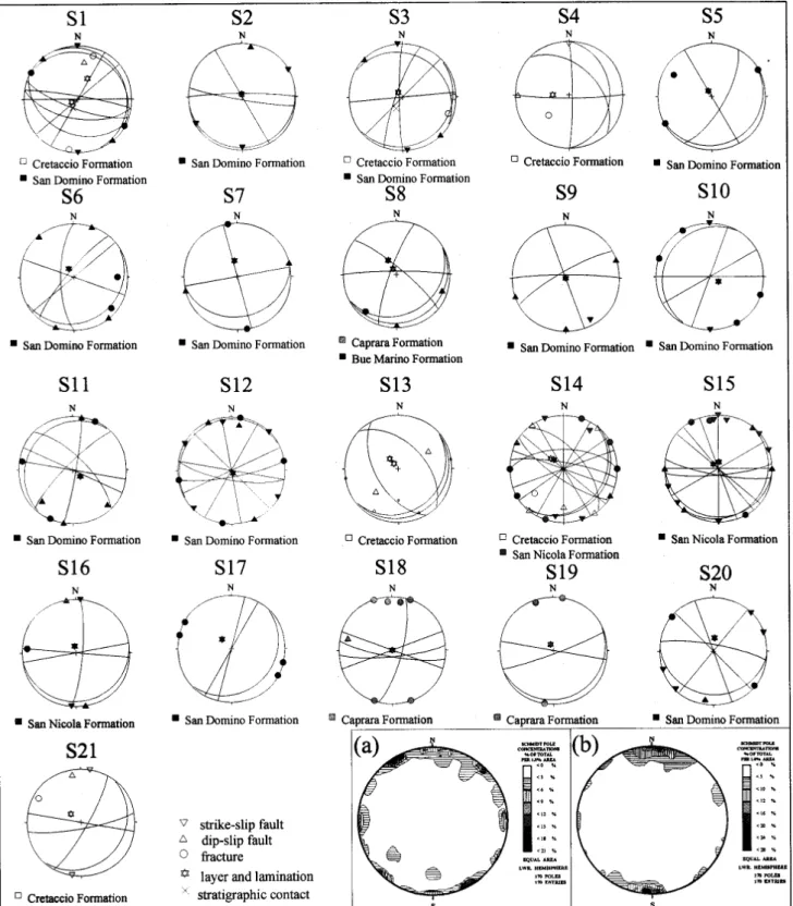
The analysis of brittle mesostructures was carried out in all the isles of the Tremiti Archipelago. Sites of measure-ments were not homogeneously distributed in the study area but were concentrate, for the most part, along the coastline (Fig. 7) due to the presence of fresh rock outcrops and easier accessibility of the places from the sea. A total of 21 mea-sure sites were taken, with 340 mesostructure orientations measured. Most sites were located on Eocene lithotypes, since they are richer in faults and fractures. The mesostruc-tures determined were divided into: a) layers and lamina-tions; b) stratigraphic contact; c) fractures; d) strike-slip faults; e) dip-slip faults. A microstructural study on the fault surfaces was not performed and this may have helped us to at least partly understand the kinematics of the different fault systems. There are numerous E–W transcurrent faults and subordinate NW oriented ones, even though in places it is dif-ficult to recognize the tectonic movement, on a mesoscopic scale at least. NE and NS directions characterise tension cracks due to gravitational displacement and fractures due to the contrast in competence between Miocene and Pliocene formations (San Nicola Isle) even if some seem to be linked with episodes of fracturing, superimposed on older faults in transpressional regime. NE and NS fractures mostly develop parallel to the local orientation of the coastline.
5 Erosional Processes and mechanism of landslides
All the isles of the Tremiti Archipelago are affected by erosional processes and landslide mechanisms concentrated above all along the coastline. Although it is istinctive to think of coastline morphology as being almost always a product of marine erosion, at the Tremiti Archipelago subaerial pro-cesses have been equally important in affecting the landforms exposed along the shoreline and the coastline recession.
The most important mechanism of coastline degradation is represented by mass movements showing different typolo-gies. The dominant, although not exclusive, mode of fail-ure at San Domino and Caprara Isles is represented by rock falls. They consist of small to medium-size falls due to undercutting at the base of the cliffs, locally, in correspon-dence to the notch level. Cliff collapses and detachments and movements of small overhanging blocks of rock followed by free fall of the debris from the cliff face can also be observed. These phenomena occur in well fractured Paleogene rocks and consist of rather instantaneous events in response to large sea storms, heavy rainfall and/or seismic shaking. Collapses of the vault of sea arches represent the last phase of the land-form erosive evolution model “cave-arch-stack”, produced by continuous wave action along structural weaknesses (at San Domino along a right-lateral NW–SE strike-slip fault) and triggered by earthquakes or storms as well.
At San Nicola Isle the mechanisms of rock slope fail-ure are varied and complex. Landslides occur as rock falls
and secondary topples (Goodman and Bray, 1977; Evans, 1981) with subordinate lateral spreads (Varnes, 1978) and multiple retrogressive slides (Hutchinson, 1969). Slope in-stability mechanisms are controlled by tension cracks and fractures due to the suitable geological conditions charac-terised by Pliocene recrystallised dolomitic calcarenites and calcisiltites which lie on the more deformable Miocene marly calcilutites and calcisiltites (Fig. 8). The contrast in compe-tence, shear strength and stiffness between the two litholo-gies is thus responsible for the presence of a network of natu-ral joints which determine the complex geometry of unstable blocks.
Rock falls and secondary topples characterise the coastal sectors adjoining the ancient town and the Benedictine church and monastery. Here, in spite of the presence at the base of the cliff of protection structures (artificial pris-matic blocks) and rock-fall blocks buffering the shoreline from wave attack, coastal cliffs continue to fail because of the intense and selective subaerial processes which degrade the slopes (Fig. 9). In particular, rain and wind erosion re-moves particles and causes drying and deterioration espe-cially of marly calcisiltites and calcilutites, and biomicrites. Wetting and drying by marine spray, splash and tide and ma-rine aerosol (Blanchard and Woodcock, 1980) are responsi-ble for the chemical and salt weathering that contribute to the general degradation of the coasts. The same can be said for the karst action, more evident at the cliff tops or on the shore platform, and the thermal stress, particularly effective on poorly cemented calcarenites (Andriani and Walsh, 2000). Rough corroded surfaces, flaking, pulverization and disag-gregation for cement cracking and dissolution weaken and make friable, above all, the levels composed of finer parti-cles. A particularly weathered level of recrystallised biomi-crites belonging to the San Nicola Fm. causes the instabil-ity of overhanging dolomitic fine grained limestone blocks overlying it and constitutes a serious natural hazard for the cultural heritage of the isle (Fig. 10). Isolated cases of rock sliding along a bedding plane characterise the eastern side of San Nicola. Lateral spreads at the southwestern end of the Isle of San Nicola involve lateral displacement of large, superficial blocks of Pliocene rocks as a result of reduc-tion in strength and stiffness of Miocene calcareous marls due to rainfall infiltration rates. For the upper formation, infiltration occurs mainly through the complex anisotropic system of joints and karst voids for which rock masses are characterised by drainage anisotropy and, for the most part, secondary permeability. Multiple retrogressive slides at the northern zone of the isle, near the cemetery, are controlled by a series of open E–W fractures identified as extension frac-tures. These fractures are probably tectonic in origin, and have been later reactivated by gravitational instability. Dur-ing our detailed surface surveys in the period 1995–2002, periodic measurements of the aperture of tension cracks par-allel to the coastline were performed; these measurements highlighted a distinct and variable time delay with rainfalls or seismic shakings for lateral spreads, secondary topples and retrogressive landslides. Rockfalls, on the other hand,
Fig. 7. Stereographic projections of the main mesostructural elements of the study area (Schmidt
equal area projection, lower hemisphere). Poles and planes representation at single measurement
station (see at Fig. 3) and density stereoplots of the fracture and fault: a) San Nicola Isle; b) San
Domino, Cretaccio and Caprara Isles.
Fig. 7. Stereographic projections of the main mesostructural elements of the study area (Schmidt equal area projection, lower hemisphere).
Poles and planes representation at single measurement station (see at Fig. 3) and density stereoplots of the fracture and fault: (a) San Nicola Isle; (b) San Domino, Cretaccio and Caprara Isles.
38 G. F. Andriani et al.: The morphogenetic evolution of the Tremiti Archipelago
Fig. 8. Secondary toppling mechanism induced by weathering of underlying marly calcisiltites (E
side of the Isle of San Nicola).
Fig. 8. Secondary toppling mechanism induced by weathering of underlying marly calcisiltites (E side of the Isle of San Nicola).
Fig. 9. W side of San Nicola. Note the fallen blocks at the bottom left, instable and overhanging
blocks not yet fallen along the whole slope. Also note the difference in dipping between the
Cretaccio Fm. at the bottom and the San Nicola Fm. at the top.
Fig. 9. W side of San Nicola. Note the fallen blocks at the bottom left, instable and overhanging blocks not yet fallen along the whole slope.
take place in response to single large sea storms or during, or shortly after, prolonged and/or intense precipitation and are triggered by a seismic shock. The scale of failures ranges from small isolated blocks of calcarenites or somewhat irreg-ularly defined marly calcisiltites up to large failure of the es-carpment itself where hundreds of tons of rock are involved. Along the eastern and western coastlines, the Isle of San Nicola is affected by continuous and, fortunately, isolated falls of unstable overhanging blocks. The last episodes of large rock falls date from 2002 and occurred in the NE part of San Domino and the SW part of Caprara during larges sea storms and heavy rains.
6 Discussion and conclusion
This study has shown that in wave dominated environments, the morphology of the coastline is strongly influenced by weathering and subaerial processes as well, including karst phenomena favoured by the geological and structural setting. The morphology of the Tremiti Archipelago is related to the geodynamic and climatic history of the area on the re-gional scale, but the resulting landforms can be considered dynamic landscape elements that are adjusting to the con-temporary morphogenic environment. A combination of soft and weak rocks, and intense sea and weathering action cause significant changes of the landscape all along the coastline and predispose the cliffs to instability through the develop-ment of selective erosion and landsliding phenomena. Mech-anisms of coastal degradation comprise different types of landslides that at San Nicola Isle are favoured by the in-tensely fractured and karstified dolomitic calcarenites and calcisiltites overlying the more deformable and softer marly calcisiltites and calcilutites. This particular geological set-ting determines failure mechanisms like secondary toppling and lateral spread, with retrogressive evolution. These are characterised by a distinct and variable time delay after rain-fall or seismic shaking. In some cases, the presence of ar-tificial and natural rock blocks at the feet of cliffs forms an effective protection structure to the wave attack during the storms, so that the instability process can be facilitated by wind and salt weathering and infiltration water and triggered by heavy rainfall and seismic shaking. Generally, marly cal-cisiltites and calcilutites are intensely affected by weathering action, while the overlapped dolomitic calcarenites and cal-cisiltites are more affected by mass movements. Indeed, most of the fallen blocks at the base of cliffs consist of lithotypes belonging to the San Nicola Fm.
The San Nicola Fm. has been selectively eroded by wind action. Wind erosion is particularly effective on the friable and low cemented calcarenites and biomicrites and causes isolated blocks of overhanging packstone dolomitic biocal-carenites covered by re-precipitated calcite to fall, followed by free fall of debris. Where jointing is intense, the strength or the degree of cementation of the rock masses is of consid-erably less significant in affecting the resulting cliff configu-ration. Isolated cases of rock sliding along a bedding plane
Fig. 10. Selective erosion phenomena in the San Nicola Fm.. At the bottom, note poorly cemented and friable calcisiltite level eroded by the wind in particular. Calcarenites covered by re-precipitated calcite at the top.
Fig. 10. Selective erosion phenomena in the San Nicola Fm. At the
bottom, note poorly cemented and friable calcisiltite level eroded by the wind in particular. Calcarenites covered by re-precipitated calcite at the top.
characterise the eastern side of San Nicola Isle. Small to medium-size rock falls due to undercutting at the base of the cliffs, in correspondence to the notch level, and detachments of small overhanging blocks of rock and debris characterise the isles of San Domino and Caprara. These phenomena oc-cur in well fractured Paleogene rocks consisting of biocal-carenites and biocalcilutes where heavy physical and chem-ical weathering including karst action reduce the strength of the rock masses and cause granular disintegration evidence. In this case, slope movement is somewhat instantaneous in response to violent sea storms, heavy rainfall and/or seismic shocks.
Arches and stacks are associated with the main faults as well. “i Pagliai”, at San Domino Isle, is a series of large aligned stacks formed along a right-lateral NW–SE strike-slip fault. These are cut in steep cliffs of fine grained and resistant Eocene dolomitic limestones and represent the last phase of the landform erosive evolution model “cave-arch-stack”, produced by continuous wave action along the struc-tural weakness. At Cretaccio Islet, “La Vecchia” is a stack, now almost completely eroded, which did not develop by following the stage of arch occurrence because of the friable
40 G. F. Andriani et al.: The morphogenetic evolution of the Tremiti Archipelago
stratigraphic units outcropping here characterised by friable and weathered calcisiltites and calcilutites of the Cretaccio Fm. This geological hazard is responsible for the high ero-sion rate of the islet, which is extinguishing gradually.
Acknowledgements. The authors would particularly like to thank
D. Liotta and M. Parise for helpful comments and suggestions. The authors are grateful to the two anonymous reviewers for the valuable comments made on the first version of the manuscript. This research was supported by 2003 M.U.R.S.T. 60% Project: “Propriet`a fisiche e caratteri idrogeologici delle rocce carbonatiche pugliesi” (Resp.: N. Walsh).
Edited by: M. Parise
Reviewed by: L. Osborne and another referee
References
Andriani, G. F. and Guerricchio, A.: Caratteri litostratigrafico-tessiturali e geomeccanici delle rocce affioranti nell’isola di S. Nicola (Isole Tremiti), Geol. Appl. e Idrog., 31, 87–105, 1996. Andriani, G. F. and Walsh, N.: Thermal properties and their
in-fluence on strength and deformability of calcareous rocks, in: Proceedings of 1th International Congress “Quarry-Laboratory-Monument“ – Pavia, 1, 81–90, 2000.
Argnani, A., Bortoluzzi, G., Favali, P., Frugoni F., Gasperini, M., Ligi, M., Marani, M., Mattietti, G., and Mele, G.: Foreland tec-tonics in the southern Adriatic sea, Mem. Soc. Geol. It., 48, 573– 578, 1994.
Baldacci, O.: Ricerche geografiche sulle Isole Tremiti, Boll. Soc. Geogr. It., 6, 410–431, 1953.
Bassani, F.: Su alcuni avanzi di pesci nell’arenaria glauconiosa delle Isole Tremiti, Rend. R. Acc. Sc. Fis. Mat. Napoli, 46,156-160, 1907.
Blanchard, D. C. and Woodcock, A. H.: The production, concentra-tion and vertical distribuconcentra-tion of the sea salt aerosol, Ann., N.Y. Acad. Sc., 338, 330–347, 1980.
Calcagnile, G. and Panza, G. F.: The main characteristics of the lithosphere-asthenosphere system in Italy surrounding regions, Pure Appl. Geoph., 119, 865–879, 1981.
Checchia Rispoli, G.: Osservazioni geologiche sull’Isola di S. Nicola di Tremiti (Mare Adriatico), Boll. R. Uff. Geol. It., 51, 1–3, 1926.
Checchia Rispoli, G.: Su di una nuova Chlamys (C. adriatica) del Miocene delle Isole Tremiti, Boll. R. Uff. Geol. It., 53, 1–4, 1928.
Ciaranfi, N., Ghisetti, F., Guida , M., Iaccarino, G., Lambiase, S., Pieri, P., Rapisardi, L., Ricchetti, G., Torre, M., Tortrici, L., and Mezzani, L.: Carta neotettonica dell’Italia meridionale, Prog. Fin. Geod. Pub. no. 515, 1–62, 1983.
Console, R., Di Giovambattista, R., Favali, P., Presgrave, B. W., and Smirglio, G.: Seismicity of the Adriatic microplate, Tectono-physics, 218, 343–354, 1993.
Cotecchia, V., Guerricchio, A., and Melidoro, G.: Geologia e pro-cessi di demolizione costiera dell’isola di San Nicola (Tremiti), Geol. Appl. e Idrog Proc., 30, 1, 491–507, 1995.
Cresta, S., Mastronuzzi, G., Pampaloni, L., and Sans`o, P.: Itinerario No. 1, Le Isole Tremiti, in: Puglia e Monte Vulture, part. I, Guide Geologiche Regionali, Soc. Geol. It., BE-MA, Milano, 108–125, 1999.
Dall’Antonia, B.: Short palaecological notes on the middle Serravallian-basal Tortonian ostracods from the Tremiti islands, Riv. It. Paleont. Strat., 108, 2, 289–296, 2002.
Dall’Antonia, B.: Deep-sea ostracods as indicators of palaeoceano-graphic changes: a case history from the middle-late Miocene of southern Italy (central Mediterranean), Terra Nova, 15, 1, 52–60, 2003.
Delle Rose, M. and Parise, M.: Il condizionamento dei fattori geologico-strutturali ed idrogeologici nella speleogenesi di grotte carsiche costiere del Salento, Proc. XIX Congr. Naz. Speleol., Bologna, 27–36, 2003.
Doglioni, C., Mongelli, F., and Pieri, P.: The Puglia uplift (SE Italy): an anomaly in the foreland of the Apenninic subduction due to buckling of a thick continental lithosphere, Tectonics, 13, 1309–1321, 1994.
Doglioni, C., Tropeano, M., Mongelli, F., and Pieri, P.: Middle-Late Pleistocene uplift of Puglia: an “anomaly” in the apenninic foreland, Mem. Soc. Geol. It. 51, 101–117, 1996.
Evans, R. S.: An analysis of secondary toppling rock failures – the stress redistribution method, Q. J. Eng. Geol., 14, 77–86, 1981. Favali, P., Mele, G., and Mattietti G.: Contribution to the study of
the Apulian microplate geodynamics, Mem. Soc. Geol. It., 44, 71–80, 1990.
Favali, P., Funiciello, R., Mattietti, G., Mele, G., and Salvini, F.: An active margin across the Adriatic Sea (Central Mediterranean Sea), Tectonophysics, 219, 109–117, 1993.
Finetti, I., Bricchi, G., Del Ben, A., Pipan, M., and Xuan, Z.: Geo-physical study of the Adria plate, Mem. Soc. Geol. It., 40, 335– 344, 1987.
Foresi, L. M., Bonomo, S., Caruso, A., Di Stefano, A., Di Stefano, E., Iaccarino, S. M., Lirer, F., Mazzei, R., Salvatorini, G., and Sprovieri, R.:High resolution calcareous plankton biostratigra-phy of the Serravallian succession of the Tremiti Islands (Adri-atic Sea, Italy), Riv. It. Paleont. Strat., 108, 2, 257–273, 2002. Funiciello, R., Montone, P., Salvini, F. and Tozzi, M.: Caratteri
strutturali del Promontorio del Gargano, Mem. Soc. Geol. It. 41, 1235–1243, 1988.
Gambini, R. and Tozzi, M.: Terziary geodynamic evolution of the Southern Adria microplate, Terra Nova, 8, 593–602, 1996. Goodman, R. E. and Bray, J. W.: Toppling of rock slopes, Proc.
spe-ciality conference on Rock Eng. For found. And Slopes, ASCE (Boulder, Colorado), vol. 2, 201–234, 1977.
Hutchinson, J. N.: A reconsideration of the coastal landslide at Folkestone Warren, Kent, Geotechnique, 19, 6-38, 1969. ING (Istituto Nazionale di Geofisica): Italian seismic catalogue
from 1450 BC to 1990, 1991.
Lirer, F., Caruso, A., Foresi, L. M., Sprovieri, M., Bonomo, S., Di Stefano, A., Di Stefano, E., Iaccarino, S. M., Salvatorini, G., Sprovieri, R., and Mazzola, F.: Astrochronological calibration of the upper Serravallian/Lower Tortonian sedimentary sequence at Tremiti Islands (Adriatic Sea, Southern Italy), Riv. It. Paleont. Strat., 108, 2, 241–256, 2002.
Lort, J. M.: The tectonics of the Eastern Mediterranean: A geo-physical review, Rev. Geophys. Sp. Phys., 9, 189–216, 1971. Mongelli, F., Marotta, A. M., and Doglioni, C.: Differenti tipi di
litosfera e differenti stili di subduzione negli Appennini, Proc. 13◦GNGTS, 13–24, 1994.
Montone, C. and Funiciello, R.: Elementi di tettonica trascorrente alle Isole Tremiti (Puglia), Rend. Soc. Geol. It., 12, 7–12, 1989. Mosetti, F. and Mosetti, P.: On the sea bottom structure near the
Tremiti islands (middle Adriatic) and related traces of vertical displacement, Boll. di Ocean. Teor. ed Appl., 2, 19–28, 1984.
Pampaloni, M. L.: Il Paleogene-Neogene delle Isole Tremiti (Puglia, Italia meridionale): stratigrafia ed analisi paleoambien-tale, PhD Thesis, Roma, 183 pp., 1988.
Pasa, A.: Appunti geologici per la paleogeografia delle Puglie, Mem. Biogeogr. Adriatica, 175–283, 1953.
Postpischl, D.: Catalogue of Italian earth-quakes from 1000 to 1980, Quad. “La ricerca Scientifica”, PFG-CNR, 114 (2B), 1– 239, 1985.
Russo, B., Sgarrella, F. and Gaboardi, S.: Benthic Foraminifera as indicators of paleoecological bottom conditions in the Serraval-lian Tremiti sections (eastern Mediterranean, Italy), Riv. It. Pale-ont. Strat., 108, 2, 275–287, 2002.
Selli, R.: Isole Tremiti e Pianosa, Note illustrative della Carta Geo-logica d’Italia, F◦156, Marco in Lamis, by Cremonini, G., Elmi, C., and Selli, R., Serv. Geol. d’Italia, Roma, 1–65, 1971. Sprovieri, R., Bonomo, S., Caruso, A., Di Stefano, A., Di
Ste-fano, E., Foresi, L. M., Iaccarino, S. M., Lirer, F., Mazzei, R., and Salvatorini, G.: An integrated calcareous plankton biostrati-graphic scheme and biochronology for the Mediterranean middle Miocene, Riv. It. Paleont. Strat., 108, 2, 337–353, 2002.
Squinabol, S.: Riassunto di uno studio geo-fisico sulle Tremiti, Atti R. Acc. Sc.di Torino, 43, 1008–1013, 1908.
Suhadolc, P. and Panza, G. F.: Physical properties of the lithosphere-asthenosphere system in Europe from geophysi-cal data, in: The lithosphere in Italy, edited by Boriani, A., Bonafede, M., Piccardo, G. B., and Vai, G. B., Acc. Naz. Lin-cei, Roma, 80, 15–40,1989.
Tellini, A.: Osservazioni geologiche sulle Isole Tremiti e sull’Isola di Pianosa nell’Adriatico, Boll. R. Com. Geol. It., 21, 442–514, 1890.
Tinti, S. and Piatanesi, A.: Numerical Simulations of the tsunami in-duced by the 1627 earthquake affecting Gargano, southern Italy, Journ. Geodynamics, 21, 2, 141–160, 1996.
Varnes, D. J.: Slope movements and types and processes in land-slides, in: Landslides and analysis control, edited by Schuster, R. L. and Krizker, R. J., Nat. Acad. Of Sc., Transp. Res. Board, Washington, Spec. Rep. 176, 11–35, 1978.