RESEARCH OUTPUTS / RÉSULTATS DE RECHERCHE
Author(s) - Auteur(s) :
Publication date - Date de publication :
Permanent link - Permalien :
Rights / License - Licence de droit d’auteur :
Bibliothèque Universitaire Moretus Plantin
Institutional Repository - Research Portal
Dépôt Institutionnel - Portail de la Recherche
researchportal.unamur.be
University of Namur
INSPEX
Lesecq, S.; Foucault, Julie; Birot, F.; De Chaumont, H.; Jackson, C.; Correvon, M.; Heck, P.;
Banach, R.; Di Matteo, A.; Di Palma, V.; Barrett, J.; Rea, S.; Van Gyseghem, J. M.; Ó'Murchú,
C.; Mathewson, A.
Published in:
Proceedings of the 2017 Design, Automation and Test in Europe, DATE 2017
DOI:
10.23919/date.2017.7927089 Publication date:
2017
Document Version
Publisher's PDF, also known as Version of record
Link to publication
Citation for pulished version (HARVARD):
Lesecq, S, Foucault, J, Birot, F, De Chaumont, H, Jackson, C, Correvon, M, Heck, P, Banach, R, Di Matteo, A, Di Palma, V, Barrett, J, Rea, S, Van Gyseghem, JM, Ó'Murchú, C & Mathewson, A 2017, INSPEX: Design and integration of a portable/wearable smart spatial exploration system. in Proceedings of the 2017 Design,
Automation and Test in Europe, DATE 2017., 7927089, Design, Automation & Test in Europe Conference &
Exhibition (DATE), 2017, Institute of Electrical and Electronics Engineers Inc., pp. 746-751, 20th Design, Automation and Test in Europe, DATE 2017, Swisstech, Lausanne, Switzerland, 27/03/17.
https://doi.org/10.23919/date.2017.7927089
General rights
Copyright and moral rights for the publications made accessible in the public portal are retained by the authors and/or other copyright owners and it is a condition of accessing publications that users recognise and abide by the legal requirements associated with these rights. • Users may download and print one copy of any publication from the public portal for the purpose of private study or research. • You may not further distribute the material or use it for any profit-making activity or commercial gain
• You may freely distribute the URL identifying the publication in the public portal ? Take down policy
If you believe that this document breaches copyright please contact us providing details, and we will remove access to the work immediately and investigate your claim.
HAL Id: cea-01519116
https://hal-cea.archives-ouvertes.fr/cea-01519116
Submitted on 5 May 2017
HAL is a multi-disciplinary open access
archive for the deposit and dissemination of
sci-entific research documents, whether they are
pub-lished or not. The documents may come from
teaching and research institutions in France or
abroad, or from public or private research centers.
L’archive ouverte pluridisciplinaire HAL, est
destinée au dépôt et à la diffusion de documents
scientifiques de niveau recherche, publiés ou non,
émanant des établissements d’enseignement et de
recherche français ou étrangers, des laboratoires
publics ou privés.
INSPEX: design and integration of a portable/wearable
smart spatial exploration system
Suzanne Lesecq, J Foucault, M Correvon, H Heck, J Barrett, S Rea, F Birot,
H de Chaumont, France Banach, J-M van Gyseghem, et al.
To cite this version:
Suzanne Lesecq, J Foucault, M Correvon, H Heck, J Barrett, et al.. INSPEX: design and integration
of a portable/wearable smart spatial exploration system. DATE’17 conference - Design, Automation
and Test in Europe, Mar 2017, Lausanne, Switzerland. �cea-01519116�
INSPEX: design and integration of a
portable/wearable smart spatial exploration system
S. Lesecq, Julie Foucault
Univ. Grenoble Alpes
CEA, LETI, Minatec Campus
38054 Grenoble, France [email protected]
M. Correvon, P. Heck
CSEM SA
2002 Neuchâtel, SwitzerlandJ. Barrett, S. Rea
Cork Institute of Technology
Cork, Ireland
F. Birot, H. de Chaumont
GoSense
Lyon, France
R. Banach
School of Computer Science
University of Manchester Manchester, M13 9PL, U.K.J.-M. Van Gyseghem
University of Namur
Namur, BelgiumC. Jackson
SensL
IrelandA. di Matteo, V. Di Palma
STMicroelectronics Srl
Via Remo De Feo 1 80022 Arzano, Naples, Italy
C. Ó’Murchú, A. Mathewson,
Tyndall National Institute
Cork, IrelandAbstract—The INSPEX H2020 project main objective is to
in-tegrate automotive-equivalent spatial exploration and obstacle detection functionalities into a portable/ wearable multi-sensor, miniaturised, low power device. The INSPEX system will be used for 3D real-time detection, location and warning of obstacles un-der all environmental conditions in indoor and outdoor environ-ments with static and mobile obstacles. Potential applications range from safer human navigation in reduced visibility condi-tions, small robot/drone obstacle avoidance systems to navigation for the visually/mobility impaired, this latter being the primary use-case considered in the project.
Keywords— surrounding perception, spatial exploration, inte-grated system, embedded, low-power, portable, wearable, health
I. INTRODUCTION
In recent years, obstacle avoidance systems for (autono-mous) vehicles has been a hot research topic. These systems combine multiple sensing technologies (e.g. LiDAR, radar, IR and visual) to detect different types of obstacles across the full range of possible lighting and weather conditions. The data from these sensors are fused and combined with vehicle orien-tation (e.g. from an Inertial Measurement Unit (IMU) and compass) and navigation subsystems. These systems are typi-cally large and heavy, and not fully integrated in a unique sys-tem. They are power hungry and require large computational capabilities. They are indeed limited to high-end vehicles and robots. Moreover, having GPS and/or IMU based traditional navigation systems is not enough to ensure safe navigation of users. Basically, knowing the exact user location in a highly smart IoT environment is not sufficient to avoid unmapped static and dynamic obstacles under all conditions of visibility.
The objective of INSPEX, a H2020 funded project, is to make obstacle detection capabilities currently implemented in
high-end vehicles available as a personal portable/wearable multi-sensor, miniaturised, low power device. The INSPEX spatial exploration system will be used for 3D real-time detec-tion, location and warning of obstacles under all environmental conditions in indoor and outdoor environments with static and mobile obstacles. Potential applications range from safer hu-man navigation in reduced visibility conditions (e.g. for fire-fighters), small robot/drone obstacle avoidance systems to nav-igation for the visually/mobility impaired.
INSPEX will integrate its smart spatial exploration system in a regular white cane for the visually impaired and provide 3D spatial audio feedback to the user on obstacle location. This use-case VIB use-case is considered highly demanding in terms of miniaturisation, integration challenges, power efficiency and needs for communication with the smart environment.
The choice as primary use-case for a smart white cane may have societal impacts. Actually, According to the World Health Organization statistics (WHO), 285 million people are visually impaired world-wide [27]. Note this the number is expected to double by 2040, due to aging and health diseases. Among these VIB people, only 5% are fully autonomous in their daily mo-bility. This lack of autonomy has partly its origin in the lack of confidence the person has in his/her mobility capabilities, and efficient use of the white cane. Electronic white canes, able to detect obstacles on the whole person height should improve VIB confidence in their mobility capabilities.
The paper is organized as follows. Section III summarises the main objectives and challenges INSPEX will tackle. Sec-tion III provides an overview of the related work while secSec-tion IV gives a first attempt of architecture for the INSPEX system. Section V summarises the INSPEX vision.
II. INSPEXOBJECTIVE AND CHALLENGES
To put it in a nutshell, INSPEX main target is to integrate automotive-equivalent spatial exploration and obstacle detec-tion funcdetec-tionalities into a wearable/portable device (Fig. 1).
This global objective breaks down in several challenges to be solved: -
1. it requires the integration of several range sensor technolo-gies (i.e. LiDAR on chip, MEMS ultrasound, Ultra Wide-Band (UWB) Impulse Radar). Basically, each sensing tech-nology compensates for drawbacks of the other ones [1] to detect obstacles of various types in different conditions. Ac-tually, one technology is not able to provide the all-conditions functionality;
2. a processing unit will be integrated in the INSPEX spatial exploration system to fuse the sensor data and build the Oc-cupancy Grid (OG) environment model. An OG is a spatial partition of the external world into a set of cells [2]. Each cell contains the occupancy probability, i.e. the probability to find an obstacle at the cell location. To get a more robust and accurate estimation of the cell state, several sensors are fused through the Multi-Sensor Fusion (MSF). Standard MSFs use Bayesian fusion [3] or evidence combination [4] that require floating point computation. Unfortunately, such implementation is too power costly to be integrated in a portable device. Basically, the OG calculation must be highly efficient for the INSPEX system to meet its integra-tion constraints (low power consumpintegra-tion, accuracy, cost and reliability);
3. the portable/wearable INSPEX system will be immerged in connected environments. As a consequence, it must provide connectivity to smarter environments and become part of the IoT. Context-aware communication capabilities will provide the user with a collaborative fabric of smart ob-jects, giving the ability to determine the context of moving objects and to dynamically blend user experiences;
4. a stringent power management strategy must be imple-mented to fulfil the system lifespan in terms of energy au-tonomy. This will be achieved by dynamic adaptation of the number of range sensors used as a function of the available energy, which will imply adaptation at run-time of the ob-stacle perception algorithm, and as a function of the envi-ronmental conditions (e.g. lighting/visibility conditions), providing context-aware autonomous reconfiguration. This power management strategy will be verified using formal methods to ensure its proper design and functioning; 5. the INSPEX system will experience similar use
environ-ments to mobile communications devices. Its reliability must be taken into account right at the design phase (de-sign-for-reliability). It will be designed to function under various weather conditions (e.g. rain, snow, sand) over a
large temperature range (typically -20°C to 40°C) but also in low visibility conditions (e.g. night, dust, smoke, fog); 6. the architecture will be modular for the system to address
several application domains;
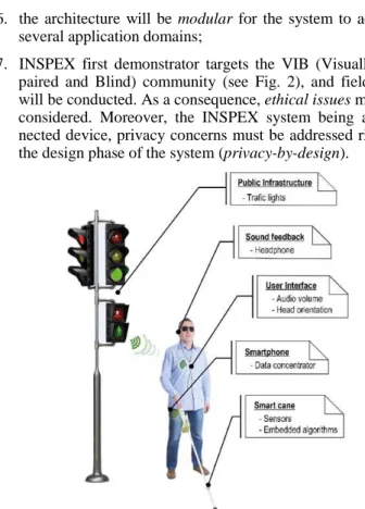
7. INSPEX first demonstrator targets the VIB (Visually Im-paired and Blind) community (see Fig. 2), and field tests will be conducted. As a consequence, ethical issues must be considered. Moreover, the INSPEX system being a con-nected device, privacy concerns must be addressed right at the design phase of the system (privacy-by-design).
Fig. 2. INSPEX initial demonstrator.
Note that the VIB use-case is seen highly demanding in terms of miniaturisation, integration challenges, power effi-ciency and needs for communication with the smart environ-ment. The INSPEX system should not exceed 200gr in weight and 100cm3 in volume. 10 hours of lifetime in continuous use are expected with an initial target for power consumption smaller than 500mW. Information regarding the location of obstacles will be provided via an extra-auricular sound feed-back via Augmented Reality 3D Audio interface, taking into account the attitude of the user head to improve the navigation experience by a better obstacle localisation and warning.
III. RELATED WORK
INSPEX main advances will cover miniaturisation and op-timisation of sensors to cope with the targeted requirements provided above. Software must be carefully integrated in order to decrease as much as possible its own power consumption. Targeting VIB as primary use-case, the INSPEX system must truly answer user needs, and offer robustness and reliability for the user to trust the system outputs. Lastly, cost may be a strong driver for system adoption.
This section now reviews these different facets of INSPEX. A. Range Sensing in all-conditions
It is well known (e.g. [20] and references therein) that ob-stacle detection systems based on ultra-sonic range sensors suffer from limited useful range (typically, < 3 m) and
difficul-ties of operating on highly reflective surfaces. Laser-based so-lutions do not suffer from these limitations, but they can be highly sensitive to ambient natural light and have difficulty identifying transparent or mirror-like surfaces. RF Radar range sensor performance is affected by the electromagnetic backscattering characteristics of the obstacle, namely its Radar Cross Section (RCS). The RCS of any obstacle is very different from its mechanical response (i.e. to ultrasound waves) or opti-cal response (i.e. to LiDAR). Ref. [21] shows that the UWB radar can be used effectively to detect and avoid obstacles through precipitation (rain, snow) and adverse environmental conditions (fog, smoke), thus being fully complementary to LiDAR which is inefficient in such conditions. Typically, RF Radars operating at 8GHz are not sensitive to clothes and light shadowing conditions and can “see” behind such short range obstacles, whereas ultra sound and LiDAR sensors will need mechanically or optically unobstructed conditions to operate. In a nutshell, Ultra Sound, RF Radar and LiDAR are comple-mentary technologies since bringing diversity in obstacle backscattering intensity. Moreover, they offer different trade-offs in terms of range, power consumption, directivity and packaging constraints. As a consequence, their co-integration will offer the all-condition functionality targeted by INSPEX.
Unfortunately, systems with all-visibility capability that combine visual, IR, LiDAR, radar and/or ultrasonic sensors are confined to large (autonomous) vehicles, large Unmanned Aer-ial Vehicles or lab prototypes with small autonomy [5], all these applications being able to cope with the high weight, computational load and power budget required for long-range 3D obstacle detection [6, 7]. No miniaturised, light-weight, low-power solution that integrates all the range sensing tech-nologies targeted by INSPEX (LiDAR-on-chip, MEMS ultra-sound, Ultra WideBand Impulse Radar) exists that is suitable for use in the consumer domain for wearable/portable naviga-tion of people, small robots or drones. Two factors contribute to this lack: the size and power budget of existing individual sensors; and the challenges of multiple sensor integration [8].
Much of the research activity in the area of weara-ble/portable obstacle detection has been done in the context of assistive technology for the VIB community [9, 10], drones [11, 12] and robotics [13], and assistive mobility for people with disabilities [14]. However, no solution offers the all-conditions functionality with the size, weight and power con-sumption consistent with a portable/wearable device.
B. Sensor Data Fusion and Occupancy Grid Calculation Fusion algorithms will fuse the data from, and manage the uncertainties of, the heterogeneous set of range sensor technol-ogies in order to ensure detection of various obstacles (size, shape, material, and colour) in 3D, at different heights and ranges and in all environmental conditions, see Fig. 3.
Many solutions already exist in the literature with pioneer works in [3, 4]. However, the approaches traditionally imple-mented in OG calculation require to manipulate probabilities. As a consequence, they require floating-point arithmetics. Re-al-time MSF computation with a growing number of cells and sensors is challenging. To accelerate MSF, parallel implemen-tation in GPUs [15, 16] or many-core platforms [17] have been proposed. All these attempts use floating-point representation
for probability estimation and fusion. Unfortunately, requiring floating-point support hinders the integration of OG-based MSF on highly constrained embedded platforms. The imple-mentation of OG-based MSF should instead make use of inte-ger computation [18] as much as possible to decrease the pow-er consumption associated with data treatment.
Fig. 3. Detection of obstacles with heterogeneous range sensors and Occu-pancy Grid obtained by data fusion.
C. Reliable Smart Navigation for People with Special Needs Navigation for people with special needs (e.g. VIB people, person in a wheelchair [19]) is not easy at all in the so-called smart cities as cities are mainly planned for sighted persons. Integrating obstacle detection and appropriate feedback togeth-er with communication with the smart city in their daily life devices (e.g. white cane, wheelchair) will improve their mobili-ty experience and get people integrated back into sociemobili-ty.
To detect a large variety of obstacles (in size, shape, colour, materials), the smart navigation system must embed a mobile detection device that integrates several range sensing technolo-gies in order to improve the performance of obstacle detection, each technology compensating for the drawbacks of others.
Most of today smart white canes only integrate ultrasound technology, either for commercial products (e;g. [22, 23]) or in research prototypes (e.g. [20, 4]), sometimes together with oth-er range sensors [15]. Most of these refoth-erences do not report power consumption figures, nor system lifetime. Moreover, their exploration range is usually quite limited (less than a few meters). These factors have also limited a widespread adoption of ultrasound solutions in other portable devices such as tablets and smartphones. On the other hand, the growth of the Internet-of-Things vision pushes Industrials to develop new sensors, actuators and smart devices smaller, more versatile, lower cost, and more power efficient. In this frame, it is clear that proximi-ty sensor for wearable electronic devices would benefit from small and low power features
Other solutions based on cameras can also be found (see e.g. [26]). However, image processing presents computational cost (and therefore power consumption) that is not consistent with the INSPEX objective of developing a low power device. Moreover, acceptability of the horseshoe-shaped device pro-posed in [26] that sits around the user’s shoulders will have to be demonstrated.
Navigating in a city is far from safe for VIB people. Even if regulations force architects, city planners and builders to design the city to make it accessible to VIB people, sooner or later, they sustain injuries (especially on the head and chest) due to
unexpected obstacles, thus decreasing their confidence in their autonomous mobility capabilities [28]. Electronic white canes offer an answer because they detect in advance obstacles, not only on the ground, but also over the whole person height, thanks to the range sensor(s) they integrate. However, they do not properly perform in all weather conditions because they integrate a unique range sensor technology for price and power consumption reasons (see Fig. 4). Moreover, as they integrate a unique range sensor technology, they cannot detect all the vari-ous obstacles (in shape, size, colour, and material) a person will encounter. As a consequence, even if mobility with an elec-tronic white cane offers safer navigation, it is currently far from fully safe.
D. Affordability of smart white canes
Affordability is one of the adoption drivers. Fig. 4 shows the price of several commercial products. The cheapest one, Smart Cane, integrates ultrasonic sensing. Mini Guide, Palm sonar, K-sonar, Ultra Cane and Mowat are also based on ultra-sound range sensors. The most expensive electronic cane inte-grates a LiDAR.
Thanks to technology advances and integration break-through, it will become possible to integrate several range sens-ing technologies in a small size low power device. Moreover, as these range sensors will target the consumer market, their price should decrease, leading to an integrated smart explora-tion system with a cost aligned with the price of today products that possess a unique sensing technology.
Fig. 4. Smart white cane affordability [27]
IV. ARCHITECTURE FIRST ATTEMPT AND REVIEW OF MAIN
SUBMODULES
Integrating in a white cane the INSPEX system offers tre-mendous challenges in terms of integration, miniaturisation and power management. Actually, the available energy is naturally constrained by the batteries embedded in the system. This re-quires a stringent optimisation on the various parts that consti-tute the INSPEX system. Second, the user cannot bear a heavy system nor accept an ugly one, pushing constraints on the inte-gration aspects (size and form factor, weight) even further. Moreover, the system reliability is very important for the user to trust the smart white cane. Lastly, cost has also strong im-pact on system adoption.
A. Archtechture overview
The spatial exploration system developed in INSPEX for the VIB use-case is made of three devices, namely the (A)
Mo-bile Detection Device, the (B) MoMo-bile Device, and the (C) Au-dio Headset Device, see Fig. 5. Each device will be split in several submodules and components that must be rigorously developed, taking into account their own allowed power re-quirements and size constraints.
Fig. 5. INSPEX smart integrated system architecture (first attempt).
The Mobile Detection Device will integrate the different range sensing technologies in order to fully cover the person height, and search “far away” the potential dangerous obstacles (e;g. those moving towards the user with “fast” speed, taking into account the maximal speed of the user). Fig. 6 shows the expected coverage of the range sensors that will be integrated in the INSPEX smart spatial exploration system.
Fig. 6. Coverage of the different range sensors integrated in the white cane
Low power context aware communication capabilities will also be integrated. Actually, the OG calculation will be embed-ded within the Mobile Detection Device integrated in the cane. Therefore, the data throughput required between the cane and the Mobile Device worn by the user is compatible with Blue-tooth Low Energy which is currently the best off-the-shelf so-lution in terms of power consumption and interoperability with the different operating systems (Android, iOS, Windows mo-bile). Thanks to its Internet connection, the Mobile Device can also offer new services to the user of the INSPEX system by allowing it to access remote point-of-interest databases and navigation services [29].
The exploration system will come with the integration of software in the hardware to make it truly smart. INSPEX will make use of a co-development approach of the practical sys-tem, together with its formal modelling and verification. Key to this is the identification of the system properties whose verifi-cation gives the most added value to the development as a whole, especially regarding to its reliability and stability. Iden-tifying such properties will make clear which kind, or kinds, of formal approach is/are best suited to the task. A significant impact on the practicability of different verification approaches comes from the limited computational resources that the light-weight (not only in mass but in energy consumption) INSPEX
architecture can support. Although it may decrease the fidelity of environment representation that is possible, it thereby also decreases the verification burden, in that only less complicated computations need to be modelled and verified.
Formal modelling and verification will help improve the safety and security of the functionality of the whole INSPEX system, including the reliability of context aware autonomous reconfiguration associated with the context-aware power man-ager. This latter will autonomously adapt which sensors will be used by the fusion algorithm, depending on the amount of en-ergy currently available (e.g. some sensors might be no more supplied because they are too power hungry) and on the envi-ronmental conditions (e.g. some sensors might be no more supplied because they badly behave in these conditions). B. Review of main submodules developped in INSPEX
The INSPEX partners bring four state-of-the-art range sen-sors to the project, namely, a MEMS ultrasound sensor, a short range large field of view LiDAR-on-chip, a long range narrow field of view LiDAR, and an UWB RF radar. The choice for these range sensing technologies is conducted by the capability of the final system to detect a large variety of obstacles (in shape, size, material, and colour) in different environmental conditions (temperature, humidity, luminosity, visibility) and particular situations (holes, stairs). Their organisation will al-low the full coverage of the person height to better alarm the user on potential dangers, included at the head height (see Fig. 6).
INSPEX will miniaturise and reduce the power consump-tion of these sensors to facilitate system integraconsump-tion and meet its requirements in terms of power consumption, size and weight of the global system. Indeed, an initial review of the envisioned architecture showed that the sensors taken from the partners without any modification, possess a too high power consumption. These range sensors will then be integrated with an IMU, environmental sensing, signal processing and power efficient data fusion techniques embedded on a low power mi-crocontroller, wireless communication, and user interface, all in a miniature, low power system designed to operate within wider smart/IoT environments.
1) MEMS ultrasound sensor
MEMS ultrasonic transducers (MUT) are used in many ap-plications, such as non-destructive testing (NDT), speed sens-ing, collision warning (‘sonar walking’), automation, flow me-tering (Doppler) and medical imaging. There are two types of MUTs, based on their actuation mechanism: capacitive MUTs (CMUTs) and piezoelectric MUTs (PMUTs). PMUTs have a lower power consumption than CMUTs, which can require a polarization voltage of around 200V. PMUTs are based on either bulk piezoelectric ceramic (with poor acoustic coupling to air or liquids) or on piezoelectric thin films (PZT, AlN) al-lowing them to be integrated into MEMS technology. When arrays of the latter are formed, ultrasound transducers allow the technology limits of conventional bulk ones to be overcome. 2D array MEMS transducers can be miniaturised to produce real-time proximity signals. Moreover, by using pulse-echo Time-of-Flight techniques, ultrasonic MEMS can work over 1m distances with sub-mm ranging accuracy. In INSPEX, a
piezo membrane MEMS (PMUT) together with its driving ASIC [30] will be optimised and integrated in the system.
2) LiDAR-on-chip
Thanks to the huge market of the smartphone and the em-bedded camera, small size and low power LiDAR are, and will be in the very near future, the best candidates for the autofocus (AF). Range and bandwidth are compatible with the VIB use case that targets obstacle detection within a range less than 1 meter (short range), and within a range of a few meters (3 to 5, long range). Such a technology is compliant with low power and low size requirements. INSPEX will optimise two LiDARs brought to the project by partners. The first one will be a Long range LiDAR with a field of view of 2.2°. Currently the proto-type has been demonstrated with a range of up to 21m [31]. This is a single channel laser and the objective is to reduce the size by developing a chip based solution for the electronics. In conjunction with the miniaturization of the single channel module in order to increase the field of view, a 64 channel ar-ray version will be developed using the same electronics plat-form as will be used for the single channel version. The second LiDAR is a short range LiDAR with a large field of view based on an off-the-shelf component. Currently this commercial on-chip sensor allows to look at a single point in the range of up to 2m and is designed for camera auto-focus solutions. Neverthe-less a fully footprint compatible second generation will be de-veloped and integrated in INSPEX. This sensor is looking at 9 independent measurement points with a field of view of 30° and a range of up to 3m. It will allow faster scanning of the near proximity with increased spatial resolution for obstacle detection.
3) Ultra WideBand RF radar
Integrated CW or FMCW RF radars for presence detection already exist in the field of e.g. domestic security on the one side and for obstacle detection in the automotive domain on the other side. In domestic security, the requirement being to detect a presence, a large scale variation of the electromagnetic echo strength is enough to get sufficient detection probability. Such limited bandwidth Doppler radars hardly provide precise range information useable in dynamic obstacle tracking systems. In the automotive field, obstacle detection radar, usually operating at 24 or 77GHz, are optimised for performance (range, angle), at the expense of higher cost, high directivity and power con-sumption of more than 500mW [32]. UWB RF radars have also been successfully applied in healthcare applications, especially for respiration rate estimation of static humans. In such appli-cation, sensitivity to very small movements is the key specifi-cation, but the measurement range is not adapted to (moving) obstacle detection needs. Smart white cane solutions integrat-ing an RF Radar do not exist today at product level. At R&D scale, one can only find early demonstrators like in [21, 32]. The objective to integrate a UWB RF radar sensor in the INSPEX system with performance of 20m sensitivity range. It will have up to 100Hz refresh rate for high performance track-ing of movtrack-ing targets, 15cm range resolution, 60° azimuth ap-erture, coarse angle of arrival estimation, and approx.. 100mW of power consumption? The form factor will be compatible with integration in a white cane.
4) User feedback
Many current electronic white canes use haptic feedback (vibration) on obstacles. However, this is limited in its ability to convey complex information, can lead to desensitisation and cognitive overload [34]. Other canes give audio feedback via earphones using audio tones that vary in frequency depending on obstacle distance. While this permits richer and more intui-tive obstacle information, it demands too much user attention and distracts from the ambient sounds that VIB people espe-cially rely on to be safe while moving and, again, imposes cog-nitive overload. To benefit from the intuitiveness and the ca-pacity of audio to convey rich information, but without these drawbacks, the INSPEX system will rely on an Augmented Reality Audio system. That uses an extra-auricular pair of ear-phones and binaural spatialisation algorithms, the user hearing virtual audio from an obstacle. Efforts will be put to take into account the user’s head orientation with respect to the position of the obstacles located on their path.
V. SUMMARY
INSPEX will develop a spatial exploration and obstacle de-tection system that will provide today automotive functionali-ties into a wearable/portable device. Several range sensing technologies will be integrated, and their measurements fused to build an occupancy grid, in order to offer all-conditions ca-pability. Augmented reality audio feedback, taking into ac-count the user’s head position will inform the user on potential dangers. Different submodules will be optimised to make the system consistent with its own requirement. As primary use-case, the INSPEX system will be integrated in a regular smart white cane. Tests in laboratory and in real-life conditions will be conducted in order to evaluate the system capability.
ACKNOWLEDGMENT
INSPEX has received funding from the European Union’s Horizon 2020 research and innovation programme under grant agreement No 730953. Its research and innovation activities will start on the 1st January 2017.
REFERENCES
[1] L. Scalise et al., “Experimental Investigation of Electromagnetic Obsta-cle Detection for Visually Impaired Users: A Comparison with Ultrason-ic Sensing”, IEEE Trans. on Inst. and Meas., Vol. 61(11), 2012. [2] H. Moravec, A. Elfes, “High resolution maps from wide angle sonar”,
IEEE ICRA Conf., 1985.
[3] S. Thrun, W. Burgard, D. Fox, Probabilistic Robotics (Intelligent Robot-ics and Autonomous Agents). The MIT Press, 2005.
[4] A. Elfes, “Occupancy grids: A probabilistic framework for robot percep-tion and navigapercep-tion,” Ph.D. dissertapercep-tion, Carnegie Mellon University, Pittsburgh, PA, USA, 1989, AAI9006205.
[5] D. Holz, et al., “Towards multimodal omnidirectional obstacle detection for autonomous unmanned aerial vehicles”, Int. Arch. Photogramm. Remote Sens. Spatial Inf. Sci., XL-1/W2, 201-206, 2013.
[6] M. Darms, “Perception for automated and assisted driving”, workshop Planning, Perception and Navigation for Intelligent Vehicles, slides available online IEEE/RSJ IROS 2015.
[7] M. Fausten, “Evolution or revolution: architecture of AD cars”, ESWEEK 2015.
[8] V. Vaganov, “Challenges of complete CMOS/MEMS systems integra-tion”, in NATO Security through Science Series B: Physics and
Bio-physics, January 2010.
[9] L. D. Dunai, et al., “Obstacle detectors for visually impaired people”, Int. Conf. on Optim. of Electrical and Electronic Equipment, 2014. [10] A. Csapó, et al., “A survey of assistive technologies and applications for
blind users on mobile platforms: a review and foundation for research”, J. on Multimodal User Interfaces, 2015.
[11] M. Koppány, et al., “Vision and control for UAVs: A survey of general methods and of inexpensive platforms for infrastructure inspection”, Sensors, Vol. 15(7), pp. 14887-14916, 2015.
[12] Y. Xiang, Y. Zhang, “Sense and avoid technologies with applications to unmanned aircraft systems: Review and prospects”, Progress in Aero-space Sciences 74, pp. 152-166, 2015.
[13] L. Pérez, et al., “Robot Guidance Using Machine Vision Techniques in Industrial Environments: A Comparative Review”, Sensors, 2016. [14] RH Krishnan, S. Pugazhenthi, “Mobility assistive devices and
self-transfer robotic systems for elderly, a review”, Intelligent Service Robot-ics, Vol. 7(1), pp. 37-49, 2014.
[15] F. Homm, N. Kaempchen, J. Ota, and D. Burschka, “Efficient occupan-cy grid computation on the GPU with LiDAR and radar for road bound-ary detection,” in Intelligent Vehicles Symposium, 2010.
[16] A. Negre, L. Rummelhard, and C. Laugier, “Hybrid sampling Bayesian Occupancy Filter,” in Intelligent Vehicles Symposium Proc., 2014. [17] T. Rakotovao, et al., “Real-time power-efficient integration of
multi-sensor occupancy grid on manycore,” IEEE ARSO conf., 2015. [18] T.Rakotovao, et al., “Multi-Sensor Fusion of Occupancy Grids based on
Integer Arithmetic”, IEEE ICRA Conf. 2016.
[19] I. Klabi, M. Slim Masmoudi, M. Masmoudi, “Advanced User Interfaces For Intelligent Wheelchair System”, 1stInt. Conf. on Advanced
Tech-nologies for Signal and Image Processing – ATSIP, 2014.
[20] L. Scalise et al., “Experimental Investigation of Electromagnetic Obsta-cle Detection for Visually Impaired Users: A Comparison with Ultrason-ic Sensing”, IEEE Trans. on Inst. and Measurement, Vol. 61(11), 2012. [21] B. Yamauchi, “Fusing ultra-wideband radar and LiDAR for small UGV
navigation in all-weather conditions”, Proc. SPIE 7692, Unmanned Sys-tems Technology XII, 76920O, 2010.
[22] K-SONAR, ultrasound white cane, sound feedback
http://www.ksonar.com/ [Accessed 2016].
[23] UltraCane, ultra-sound white cane, vibration feedback
https://www.ultracane.com/ [Accessed 2016].
[24] N.Mahmud, et al., “Vibration and Voice Operated Navigation System for Visually Impaired Person”, 3rd Int. Conf. on Informatics, Electronics
& Vision, 2014.
[25] S. A. Bouhamed, et al., New electronic cane for visually impaired peo-ple for obstacle detection and recognition, IEEE Int. Conf. on Vehicular Electronics and Safety, 2012.
[26] Project BLAID http://www.toyota.com/usa/story/effect/projectblaid.html [27] WHO, “Visual impairment and blindness,” 2012,
http://www.who.int/mediacentre/factsheets/fs282/en/
[28] R. Manduchi, S. Kurniawan, “Mobility-Related Accidents Experienced by People with Visual Impairment”, Research and Practice in Visual Impairment and Blindness, 2011.
[29] A. McGibney, et al., “MapUme: Smartphone Localisation as a Service a cloud based architecture for providing indoor localisation services”, IPIN Int. Conf. on Indoor Positioning and Indoor Navigation, 2012 [30] G.Matrone, et al., “Volumetric CMUT-Based Ultrasound Imaging
System Simulator With Integrated Reception and µ-Beamforming Electronics Models”, IEEE Trans. On Ultrasonic, Ferroelectrics, and Frequency Control, 2014.
[31] S. Gnecchi, et al., “SiPM Sensors for ToF Ranging Applications”, SPIE Photonics West, 2016.
[32] http://www.siliconradar.de/datasheets/Datenblatt_TRXS2_024_05.pdf
[33] S. Pisa, et al., “A FMCW Radar As Electronic Travel Aid For Visually Impaired Subjects”, XXI IMEKO World Congress “Measurement in Research and Industry”, 2015.
[34] R. Sigrist, et al., “Augmented visual, auditory, haptic, and multi-modal feedback in motor learning: A review”, Psychon Bull Rev 20, 2013.

![Fig. 4. Smart white cane affordability [27]](https://thumb-eu.123doks.com/thumbv2/123doknet/14504835.719916/6.892.486.814.173.337/fig-smart-white-cane-affordability.webp)