HAL Id: hal-02880575
https://hal.inrae.fr/hal-02880575
Submitted on 25 Jun 2020
HAL is a multi-disciplinary open access
archive for the deposit and dissemination of
sci-entific research documents, whether they are
pub-lished or not. The documents may come from
teaching and research institutions in France or
abroad, or from public or private research centers.
L’archive ouverte pluridisciplinaire HAL, est
destinée au dépôt et à la diffusion de documents
scientifiques de niveau recherche, publiés ou non,
émanant des établissements d’enseignement et de
recherche français ou étrangers, des laboratoires
publics ou privés.
hillslope runoff and sediment connectivity in
Mediterranean dry reclaimed slope systems
Mariano Moreno-De-Las-Heras, Luis Merino-Martín, Patricia Saco, Tiscar
Espigares, Francesc Gallart, Jose Nicolau
To cite this version:
Mariano Moreno-De-Las-Heras, Luis Merino-Martín, Patricia Saco, Tiscar Espigares, Francesc Gallart,
et al.. Structural and functional control of surface-patch to hillslope runoff and sediment connectivity
in Mediterranean dry reclaimed slope systems. Hydrology and Earth System Sciences, European
Geosciences Union, 2020, 24 (5), pp.2855-2872. �10.5194/hess-24-2855-2020�. �hal-02880575�
https://doi.org/10.5194/hess-24-2855-2020 © Author(s) 2020. This work is distributed under the Creative Commons Attribution 4.0 License.
Structural and functional control of surface-patch
to hillslope runoff and sediment connectivity
in Mediterranean dry reclaimed slope systems
Mariano Moreno-de-las-Heras1,2, Luis Merino-Martín3,4, Patricia M. Saco5,6, Tíscar Espigares7, Francesc Gallart1, and José M. Nicolau8,9
1Institute of Environmental Assessment and Water Research (IDAEA, CSIC), 08034 Barcelona, Spain 2Desertification Research Centre (CIDE, CSIC-UV-GV), 46113 Moncada, Valencia, Spain
3University of Montpellier, AMAP, INRAE, CIRAD, CNRS, IRD, PS2 TA/A51, 34 398 Montpellier CEDEX 5, France 4CEFE, Univ. Montpellier, CNRS, EPHE, IRD, Univ. Paul Valéry, Montpellier, France
5Civil, Surveying and Environmental Engineering, The University of Newcastle, 2308 Callaghan, New South Wales, Australia 6Centre for Water Security and Environmental Sustainability, The University of Newcastle,
2308 Callaghan, New South Wales, Australia
7Department of Life Sciences, Faculty of Sciences, University of Alcalá, 28805 Alcalá de Henares, Madrid, Spain
8Department of Agrarian and Environmental Sciences, Technological School, University of Zaragoza, 22071 Huesca, Spain 9Environmental Sciences Institute of Aragon, University of Zaragoza, 50009 Zaragoza, Spain
Correspondence: Mariano Moreno-de-las-Heras (mariano.moreno@idaea.csic.es) Received: 24 October 2019 – Discussion started: 2 January 2020
Revised: 12 April 2020 – Accepted: 24 April 2020 – Published: 29 May 2020
Abstract. Connectivity has emerged as a useful concept for exploring the movement of water and sediments between landscape locations and across spatial scales. In this study, we examine the structural and functional controls of surface-patch to hillslope runoff and sediment connectivity in three Mediterranean dry reclaimed mining slope systems that have different long-term development levels of vegetation and rill networks. Structural connectivity was assessed using flow path analysis of coupled vegetation distribution and surface topography, providing field indicators of the extent to which surface patches that facilitate runoff and sediment produc-tion are physically linked to one another in the studied hill-slopes. Functional connectivity was calculated using the ra-tio of patch-scale to hillslope-scale observara-tions of runoff and sediment yield for 21 monitored hydrologically active rainfall events. The impact of the dynamic interactions be-tween rainfall conditions and structural connectivity on func-tional connectivity were further analysed using general lin-ear models with a backward model structure selection ap-proach. Functional runoff connectivity during precipitation events was found to be dynamically controlled by antecedent
precipitation conditions and rainfall intensity and strongly modulated by the structural connectivity of the slopes. On slopes without rills, both runoff and sediments for all events were largely redistributed within the analysed hillslopes, re-sulting in low functional connectivity. Sediment connectivity increased with rainfall intensity, particularly in the presence of rill networks where active incision under high-intensity storm conditions led to large non-linear increases in sediment yield from the surface-patch to the hillslope scales. Overall, our results demonstrate the usefulness of applying structural-and functional-connectivity metrics for practical applications and for assessing the complex links and controlling factors that regulate the transference of both surface water and sedi-ments across different landscape scales.
1 Introduction
Surface processes in Mediterranean landscapes are affected by multiple factors (e.g. rainfall characteristics, soil surface properties, vegetation, micro-topography and landforms) that
interact at a variety of spatial scales (from the surface-patch to the plot, hillslope and catchment scales), resulting in in-tricate responses of runoff and sediment yield (Puigdefabre-gas et al., 1999; Calvo-Cases et al., 2003; Cammeraat, 2004; Yair and Raz-Yassif, 2004; Boix-Fayos et al., 2006; Moreno-de-las-Heras et al., 2010; Mayor et al., 2011; Gallart et al., 2013; Marchamalo et al., 2016). In these complex systems, connectivity has emerged as a useful concept for studying the movement and transference of surface water and water-borne materials (e.g. sediments, nutrients and seeds) between land-scape locations or scales (Bracken and Croke, 2007; Wain-wright et al., 2011; Bracken et al., 2013; Reaney et al., 2014; Keesstra et al., 2018; Saco et al., 2020).
Two conceptual elements of hydrological connectivity that facilitate the analysis of the spatial and temporal dynam-ics of both runoff and sediments throughout hillslopes and catchments were proposed: structural and functional connec-tivity (Turnbull et al., 2008; Wainwright et al., 2011; Okin et al., 2015). Structural connectivity refers to the spatial ar-rangement of hydrologically significant units or elements, and it captures the extent to which these units are physically linked to each other in order to allow for the transfer of wa-ter and sediments. The second, functional (or process-based; Bracken et al., 2013) connectivity, refers to the activation of connections of runoff and/or sediment pathways during a par-ticular rainfall event. Functional connectivity of runoff de-pends on the dynamics of overland flow generation, routing and downward re-infiltration. For sediments, functional con-nectivity is a function of the detachment, entrainment, depo-sition and remobilization of sediments across scales (wright et al., 2011; Bracken et al., 2013; Turnbull and Wain-wright, 2019).
Multiple studies have focused on the analysis of the ef-fects of landscape structural components of connectivity on runoff and soil erosion, particularly in Mediterranean dry and other dryland systems. In water-limited environments with patchy vegetation, measures related to the spatial organiza-tion (i.e. the pattern, patch size and landscape posiorganiza-tion) of vegetation explain runoff and soil erosion better than aver-age vegetation cover (Bautista et al., 2007; Arnau-Rosalén et al., 2008; Puigdefabregas, 2005). The spatial arrangement of surface features (e.g. vegetation cover, rills, gullies, channels and terraces) were shown to control the distribution of source and sink elements in these landscapes from a structural-connectivity perspective, largely driving the production and transference of water and sediments across scales (Cammer-aat, 2004; Turnbull et al., 2010; Merino-Martín et al., 2015; Marchamalo et al., 2016; Moreno-de-las-Heras et al., 2019). Structural connectivity can be highly dynamic over long time periods (e.g. decades or longer) as a result of changes in veg-etation, land use and surface morphology. However, struc-tural connectivity is generally considered a static landscape feature over the time periods of interest (e.g. the hydrologi-cal year), which has facilitated the application of this concept in hydrological and geomorphological studies using surface
contiguity indexes (Heckmann et al., 2018, and references therein).
The interactions between precipitation conditions and the structural connectivity of a landscape determine functional connectivity (Wainwright et al., 2011; Bracken et al., 2013; Reaney et al., 2014; Okin et al., 2015). Surface patches re-spond to rainfall characteristics and (antecedent) soil mois-ture conditions to determine the initiation of runoff and thus, the transport of water and sediments through the land-scape (Cantón et al., 2011; Mayor et al., 2011; Rodríguez-Caballero et al., 2014). Thus, functional connectivity may dynamically vary between rainfall events. There is little con-sensus, however, on how to quantify functional connectiv-ity (Okin et al., 2015). Several research approaches were ap-plied to analyse functional aspects of connectivity in terms of the continuity of runoff and sediment fluxes along hillslopes, landscapes and catchments. These approaches cover a wide array of methods including hierarchical (i.e. nested, strati-fied and/or scaled) runoff and sediment yield measurements (Cammeraat, 2004; Yair and Raz-Yassif, 2004; Moreno-de-las-Heras et al., 2010; Mayor et al., 2011), field-based map-ping and modelling of active runoff and sediment flow paths (Arnau-Rosalén et al., 2008; Marchamalo et al., 2016; Turn-bull and Wainwrigth, 2019), fallout radionuclide and rare-earth-element sediment tracing applications (Masselink et al., 2017a; Moreno-de-las-Heras et al., 2018), or particle-in-motion tracers and overland flow sensors (Hardy et al., 2017; Masselink et al., 2017b).
Mediterranean dry reclaimed mining slope systems (here-after RMSSs) are characterized by the local convergence of high storm erosivity, poorly developed soils, scarce vegeta-tion cover and rough topography. These characteristics can lead to the genesis of important amounts of overland flow, promoting soil erosion processes, which typically lead to rill and gully development (Nicolau and Asensio, 2000; Nicolau, 2002; Moreno-de-las-Heras et al., 2009; Martín-Moreno et al., 2018). The analysis of runoff and sediment connectivity has a critical relevance for landscape management in these human-made, water-limited environments, where the func-tional components of runoff and sediment connectivity (e.g. the processes that initialize, maintain or interrupt the fluxes of water and sediments from the surface-patch to the broader hillslope scale) can shape on-site structural-connectivity fac-tors (e.g. vegetation patterns, spatial distribution of rill net-works and sedimentation areas) over long periods, condition-ing the long-term eco-geomorphic stability of the reclaimed systems (Moreno-de-las-Heras et al., 2011a). In fact, within-slope spatial redistribution of runoff and sediment fluxes in these Mediterranean dry RMSSs feeds back into patch-scale hydrological behaviour by controlling the availability of wa-ter and soil resources for the long-wa-term development of veg-etation cover (Espigares et al., 2011; Moreno-de-las-Heras et al., 2011b; Merino-Martín et al., 2015). Furthermore, the magnitude and cross-scale transmission of runoff and sedi-ments in these RMSSs largely determines their off-site
ef-fects in the form of runoff and sediment conveyance to down-stream channels and environments (Martín-Moreno et al., 2018).
In this study, we apply the concepts of structural and func-tional connectivity to analyse the factors that control the transference of water and sediments from the surface-patch to the hillslope scale in three Mediterranean dry RMSSs that differ in their vegetation organization and landform features (i.e. rill networks). Our assessment is based on the analy-sis of patch-to-hillslope runoff and sediment flow continu-ity of 21 active events monitored during 2007–2008 using a hierarchical (scaled) measurement approach (Merino-Martín et al., 2012a). Specifically, our analysis aims to determine how structural components of the three reclaimed slope sys-tems (i.e. the spatial distribution of vegetation cover and micro-topography, including rill networks) dynamically in-teract with rainfall characteristics (i.e. storm depth, rainfall duration and intensity) and antecedent storm conditions to generate spatially continuous runoff and sediment fluxes.
2 Materials and methods
2.1 Study area
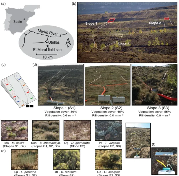
This work was carried out in the Utrillas field site (Fig. 1a), an experimental station located in “El Moral”, a reclaimed surface coal mine in central eastern Spain (40◦4702400N, 0◦4904800W; 1100 m). The climate is Mediterranean dry, with a mean annual air temperature of 11◦C. Mean annual pre-cipitation (MAP) is about 500 mm, most of which occurs in spring and autumn. Potential evapotranspiration (PET; Harg-reaves and Samani, 1985) is around 900 mm, and the hydro-logical deficit (MAP−PET) is approx. 400 mm, concentrated in the summer months (López-Martín et al., 2007). The av-erage number of precipitation events in the area is 50–70 per year. Remarkable is the rainfall erosivity of high-intensity late-spring and summer convective thunderstorms (< 10 % rainfall events), which can reach up to 100 mm rainfall in 24 h (Peña et al., 2002).
The study site encompasses three experimental slopes, all north facing with a general gradient of about 20◦ (Fig. 1b and d), which were surveyed intensively between Octo-ber 2007 and DecemOcto-ber 2008 (Merino-Martín et al., 2012a, 2015). The slopes were reclaimed during 1987–1989 with the following procedure. First, a 100 cm thick layer of clay– loam overburden substratum was spread over the slopes. Next, the surface was prepared for revegetation by applying cross-slope ploughing to create a transversal pattern of sur-face roughness that would facilitate water storage and infil-tration. Finally, the slopes were sown with a seed mixture of perennial grasses and leguminous herbs (Festuca rubra, Fes-tuca arundinacea, Poa pratensis, Lolium perenne, Medicago sativaand Onobrychis viciifolia).
Although the three slopes were originally restored using the same procedure, their subsequent evolution and ecosys-tem recovery level displayed differences due to variations in their geomorphological design, particularly in the upper section of the slopes. Specifically, these variations occurred due to the existence of a very steep (40◦) and bare runoff-contributing berm integrated at the top of two of the experi-mental slopes (Slope 1 and Slope 2, with berm sizes of 50 and 20 m2, respectively; Fig. 1b). This runoff-contributing struc-ture promoted soil erosion and conditioned the early dynam-ics of the experimental slopes, particularly in Slope 1, where the berm area is bigger and produces important amounts of overland flow. These mechanisms resulted in the forma-tion of a deeply incised (up to 35 cm depth in the middle and lower sections of the slope) and fairly dense (0.6 m m−2 density) rill network in Slope 1 and, also, important varia-tions in vegetation development among the three experimen-tal slopes. After 20 years of dynamic evolution from initial reclamation, the three experimental slopes showed different levels of vegetation development (30 %, 45 % and 55 % cover for Slope 1, Slope 2 and Slope 3, respectively), soil ero-sion intensity (2007–2008 sediment yield was 1824, 81 and 4 g m−2for Slope 1, Slope 2 and Slope 3, respectively) and runoff production (2007–2008 runoff coefficient was 14.5 %, 2.1 % and 0.4 % for Slope 1, Slope 2 and Slope 3, respec-tively; Table S1 in the Supplement).
2.2 Field acquisition methods of hydro-sedimentary and precipitation data
We monitored runoff and soil erosion in the experimental slopes by applying a scaled approach (Merino-Martín et al., 2012a) that included naturally delimited runoff and erosion plots distributed at (a) the hillslope scale and (b) the surface-patch scale (Fig. 1c).
Three broad, hillslope-scale runoff and erosion plots were installed in naturally delimited catchments in the experimen-tal slopes (catchment areas of 498, 511 and 1474 m2 for Slope 1, Slope 2 and Slope 3, respectively; Fig. 1d). At the foot of each catchment, two collectors and a central ce-mented outlet were installed. From the outlet, runoff was routed through a pipe into 200 L storage tanks connected by Geib (1933) multi-slot runoff dividers (Fig. 1d).
At the patch scale, seven different soil surface types were identified within the experimental slopes as a function of veg-etation community composition and soil surface traits (e.g. dominant plant species, species richness, cover, presence of soil surface crusts and small pedestals). The soil surface-patch types (Fig. 1e; Table S1) included barely covered ar-eas (< 5 % cover) with scattered clumps of perennial forbs dominated by Medicago sativa (Ms); sparsely covered ar-eas (cover approx. 30 %) with grasses dominated by Dactylis glomerata (Dg) or with dwarf shrubs dominated by either Santolina chamaecyparissus(Sch) or Thymus vulgaris (Tv); and finally, densely covered areas (> 70 % cover) dominated
Figure 1. The Utrillas field site: (a) location map; (b) frontal view of the three experimental slopes (40◦steep, berm sections located at the top of Slope 1 and Slope 2 are highlighted in red); (c) schematic representation of the experimental layout in the slopes (a hierarchical, scaled approach with patch-scale and hillslope-scale runoff and erosion plots); (d) frontal view of the hillslope-scale plots (catchment plots) and their general characteristics (vegetation cover and rill density); (e) detailed view of the seven surface types (vegetation communities) identified in the experimental slopes by Merino-Martín et al. (2012a); (f) an example of patch-size plot showing a small detail (right picture) of the Gerlach trough runoff and sediment collection systems. Names of the dominant plant species for the surface types: Ms, Medicago sativa; Sch, Santolina chamaecyparissus; Dg, Dactylis glomerata; Tv, Thymus vulgaris; Lp, Lolium perenne; Br, Brachypodium retusum; and Gs, Genista scorpius.
by grass species (Lolium perenne, Lp, and Brachypodium re-tusum, Br) or by shrubs (Genista Scorpius, Gs). In order to monitor runoff and sediment yield at the patch scale, 27 Ger-lach (1967) troughs (each 0.5 m wide and connected to 100 L drums for runoff and sediment storage; Fig. 1f) were dis-tributed in the slopes between the seven surface types. The spatial organization of the surface types and contributing area of the Gerlach troughs in the experimental slopes was deter-mined in the field using a total station (Topcon GTS212). The catchment area of the Gerlach troughs, delimitated by surface
micro-topography and vegetation barriers, ranged from 1 to 16 m2(Table S1).
The runoff amount was measured in the storage tanks and drums within a day after each runoff event (runoff-producing events occurring within a 24 h period were considered to be-long to the same event). The stored runoff was stirred, and 1 L representative samples were taken. Sediment concentra-tions were determined by oven-drying the collected runoff samples (at 105◦C) until a constant weight was achieved.
A set of six precipitation variables (Table 1) were measured for each of the monitored events. The
rain-Table 1. Precipitation condition variables determined for each mon-itored runoff event.
Description Units Dp Storm depth mm Rd Rainfall duration h I15 15 min max rainfall intensity mm h−1
I30 30 min max rainfall intensity mm h−1
Im Mean rainfall intensity mm h−1
API Antecedent precipitation index mm
fall depth (Dp, mm) for each event was measured using three bulk precipitation collectors located within the exper-imental slopes. Rainfall duration (Rd, h) and both 15 and 30 min maximum rainfall intensities (I15 and I30,
respec-tively, mm h−1) were measured using an automated record-ing rain gauge (Davis GroWeather) installed in the experi-mental station. The mean rainfall intensity (Im, mm h−1) for
each event was calculated as the ratio of total precipitation to rainfall duration. In order to characterize the antecedent rainfall conditions of the events, we used the antecedent pre-cipitation index (API, mm; Kohler and Linsley, 1951). API is calculated as API = −T X t =−1 Ptk−t, (1)
where Pt (mm) is the precipitation on a given day t , k is
a dimensionless decay coefficient that represents a mea-sure of the declining influence of past precipitation on cur-rent soil moisture state and T (d) is the antecedent period considered for the calculation of the index. We used fort-nightly soil moisture records obtained in the experimental slopes (3 × 12 TDR – time domain reflectometry – profiles of 50 cm depth; Merino-Martín et al., 2015) to parameterize API for this study (k = 0.98 and T = 10 d; complementary field-calibration details of API parameters in Sect. S1 in the Supplement).
A total of 21 rainfall events out of 74 precipitations produced runoff and erosion at the patch scale during the study period (October 2007–December 2008; total rainfall of 703 mm), although only 17 generated significant hydro-logical responses at the hillslope scale (Merino-Martin et al., 2012a). We used the complete set of 21 hydrologically active events for this study (full hydro-sedimentary and precipita-tion data are available in Table S2).
2.3 Structural-connectivity quantification: distribution of sources and sinks
Previous research carried out in the Utrillas field site apply-ing small-scale (0.25 m2) rainfall simulations (Moreno-de-las-Heras et al., 2009) indicated that surface patches with vegetation cover under 50 % can generate important amounts
of runoff and sediments, thus acting as “sources” of water runoff and sediments within the slopes. Conversely, surface patches with vegetation cover above 50 % regulate soil sur-face hydrological responses very efficiently and may also operate as flow obstructions, behaving as “sinks” of runoff and sediments. Structural connectivity for this study (i.e. the physical linkage of runoff and sediment source areas within the experimental slopes) has been quantified from coupled analysis of binary maps of vegetation density (above or be-low 50 % cover) derived from high-resolution multispectral aerial photography and field-based digital elevation mod-els (DEMs) of the experimental slopes.
Multispectral information of the experimental slopes was obtained from a high-resolution four-band aerial image (0.5 m resolution) captured by the Spanish National Plan for Aerial Orthophotography (PNOA, Spanish National Ge-ographic Institute) in late spring 2009. We used the red and near-infrared bands to generate raster maps of the normal-ized difference vegetation index (NDVI). The NDVI is a chlorophyll-sensitive vegetation index that strongly corre-lates with vegetation cover and green biomass density (An-derson et al., 1993). We applied field-based NDVI thresh-olding (Scanlon et al., 2007) to transform the raster NDVI maps of the experimental slopes into binary maps of sinks and sources of runoff and sediments. First, we used reference vegetation density data collected in the field (3 × 35 quadrats of 0.25 m2size regularly distributed within the experimen-tal slopes; Merino-Martín et al., 2012b) for determining the proportional abundance of sink areas with above 50 % vege-tation cover for each analysed slope system. We then classi-fied the pixels in each slope by thresholding the NDVI values in the raster maps to match the ground-based proportional abundance of sink areas obtained in the first step. The ap-plication of this image processing methodology resulted in the generation of a high-resolution binary map product rep-resenting the distribution of sinks and sources (> 50 % and <50 % cover patches, respectively) of runoff and sediments for each experimental slope.
Detailed digital elevation data for the analysis of structural connectivity were obtained from a topographical field survey (Merino-Martín et al., 2015). DEM break lines and filling points (∼ 0.5 points m−2data density) were obtained using a total station (Topcon GTS212). Scattered elevation data were interpolated using thin-plate splines to match the (0.5 m res-olution) grid-based binary maps of sources and sinks of the experimental slopes.
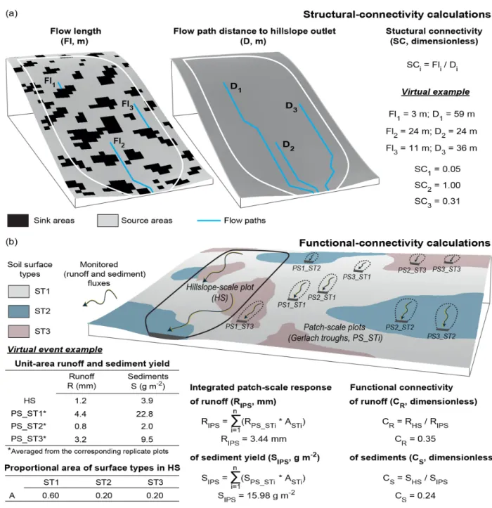
We used the flow length calculator developed by Mayor et al. (2008) along with the source and sink binary maps and the obtained DEM data to analyse the physical linkage of runoff and sediment source areas in the experimental slopes (Fig. 2a). This calculator applies a D8 flow-routing algorithm (O’Callaghan and Mark, 1984) to determine the length of the runoff paths in the downslope direction (flow length, Fl, m) until a sink (i.e. > 50 % vegetation cover) or the outlet of the hillslope is reached. Flow path measurements were
standard-ized to obtain a structural-connectivity indicator (SC, dimen-sionless). Standardization was carried out for every pixel in the raster maps of the experimental slopes by determining the ratio of the calculated Fl values to the topography-based flow path distance (D, m) of the pixels to the outlet of the hill-slopes (SCi=Fli/Di; Fig. 2a). SC values range from 0 (sink
pixels) to 1 (source pixels connected to the outlet of the slope system without the interference of any sinks).
2.4 Functional-connectivity quantification: flow continuity across scales
Functional connectivity for this study is defined as the con-tinuity of runoff and sediment fluxes from the surface-patch to the hillslope scales. We applied a two-step approach to determine functional connectivity (Fig. 2b). First, for each event and experimental slope, we determined the integrated patch-scale response of runoff and sediment yield (RIPS, mm,
and SIPS, g m−2, respectively). This integrated patch-scale
re-sponse was computed by weighing the surface-patch runoff and sediment observations (from the data recorded in the Gerlach troughs) with the proportional area of the differ-ent soil surface types monitored in each slope system. Sec-ond, functional connectivity, assessed as the cross-scale flow continuity of runoff and sediment fluxes (CR and CS,
re-spectively), was quantified for each event and experimen-tal slope as the ratio of the hydrological and sediment ob-servations recorded in the broad, hillslope-scale plots (RHS,
mm, and SHS, g m−2, respectively) to the determined,
inte-grated patch-scale responses of runoff and sediment yield (CR=RHS/RIPSand CS=SHS/SIPS; Fig. 2b).
The functional connectivity of runoff (CR, dimensionless)
ranges between 0 and 1. CRequals 0 when there is complete
within-slope spatial redistribution of runoff (i.e. no runoff generated at the surface-patch scale reaches the outlet of the slope system). CRincreases as runoff redistribution
de-creases across scales and equals 1 when all runoff generated at the patch scale reaches the outlet of the slope system. Pre-vious research in our study site suggests that any further con-tributions to hillslope runoff production (e.g. subsurface re-turn fluxes captured by the rill networks) have a marginal impact on the hydrological response of these water-limited systems (Nicolau, 2002; Moreno-de-las-Heras et al., 2010; Merino-Martín et al., 2012a).
The functional connectivity of sediments (CS,
dimension-less) decreases from 1 to 0 when significant amounts of sed-iments generated at the patch scale are deposited within the slope system before reaching the outlet. However, CS may
take values over 1 if active rill incision takes place in the experimental slopes, causing the entrainment of significant amounts of sediments between the patch and hillslope scales (Moreno-de-las-Heras et al., 2010).
2.5 Data analysis and statistics
2.5.1 General patterns of structural and functional connectivity
For each experimental slope, we calculated the cumulative probability distribution function (CDF) of the structural-connectivity (SC) values. Differences between the three experimental slopes on the SC probability distribution (probability of SCi≥SC) were analysed using two-sample
Kolmogorov–Smirnov tests. Mean SC values (hereafter SC) were calculated for each slope system as an integrative indi-cator of the structural connectivity at the hillslope-scale level. Differences between the three experimental slopes on the functional connectivity of runoff (CR) and sediments (CS)
were tested for the set of 21 hydrologically active events recorded during the study period using Kruskal–Wallis ANOVA. In addition, the broad, hillslope-scale hydrological (sediment) responses of the experimental slopes were tested against the analysed, per-event functional connectivity of the studied systems by determining the best-fitting regression function linking the determined runoff (sediment) connectiv-ity values and the observed hillslope runoff coefficients (soil losses).
2.5.2 Controlling factors of runoff and sediment connectivity
We applied the general descriptors of precipitation charac-teristics and antecedent rainfall conditions (Table 1) and the obtained SC index of structural connectivity to determine the main controlling factors that drive the functional responses of runoff and sediment connectivity in the experimental slopes for the studied (21 hydrologically active) runoff and erosion events. We modelled CRand CS using general linear
mod-els (GLMs; Christensen, 2002) and a backward model struc-ture selection approach. First, an exploratory pre-screening analysis of the dynamic relationships between the functional-connectivity indexes (CRand CS) and both the rainfall
char-acteristics and antecedent precipitation conditions was per-formed using Spearman’s R correlations. Second, the pre-screened variables that showed significant correlations (at α =0.05) with the CRand CSvalues of the storms were
fur-ther applied to model the surface-patch to hillslope transfer (or flow continuity) of runoff and sediments.
In order to identify the set of explanatory variables that produce the best model for CRand CSprediction, alternative
GLM configurations were compared. These alternative GLM configurations included (i) SC as a factor with three levels representing the structural connectivity of the three experi-mental slopes, (ii) all the possible combinations of signifi-cant (Spearman’s R) pre-screened variables of rainfall char-acteristics and antecedent conditions, and (iii) the interaction terms between SC and the pre-screened variables included in each comparison of model structure. The Akaike information
Figure 2. Schematic representation and virtual examples of the calculations for the quantification of (a) structural connectivity (SC) and (b) the functional connectivity of both runoff (CR) and sediments (CS). Structural connectivity for any location in the hillslope (SCi) is
calculated as the ratio of flow length (Fli, length of the runoff path until a sink is reached downslope of the hillslope location) to the
(topography-based) flow path distance of the location to the hillslope outlet (Di). For each precipitation event, functional connectivity of
runoff, CR(of sediments, CS), is calculated as the ratio of hillslope-scale runoff, RHS(sediment yield, SHS), to the integrated (i.e.
area-weighed) patch-scale production of runoff, RIPS(of sediments, SIPS). The virtual slope in (b) includes three replicate PS_ST patch-scale
plots for each of the three displayed STi soil surface types.
criterion (AIC; Akaike, 1974) and the adjusted coefficient of determination (Adj R2), which represent a trade-off between model complexity and the goodness of fit, were used to select the best model for CRand CSprediction. Finally, the model
root-mean-squared error (RMSE) and both the effect size (eta-squared values, η2) and significance of the model pre-dictors were evaluated for the selected, optimal GLM
config-urations. While CSmay take values (largely) above 1 when
active rilling takes place, CRis constrained to values ≤ 1 and
consequently, may asymptotically approach 1 as rainfall in-creases. The asymptotic behaviour of CRviolates the GLM
assumption of linearity for large values of the model predic-tors. We, therefore, applied logarithmic transformation to the
precipitation co-variables (Table 1) to comply with the GLM assumptions for CRmodelling.
All data analyses and statistics were developed within the R statistical computing and language programming software environment (R Core Team, 2019).
3 Results
3.1 Source and sink distribution and structural connectivity of the slopes
Runoff and sediment sinks in Slope 1 were particularly con-centrated in its central section, mainly distributed as grass patches dominated by Lolium perenne (Lp soil surface-patch type; Fig. 3a). A well-developed rill network (density of 0.6 m m−2) linked the runoff and sediment source areas lo-cated at the top of the experimental slope with both the source areas distributed at the bottom of the slope and the outlet of the system. Similarly, runoff and sediment sink areas for Slope 2 (Fig. 3b) were preferentially distributed in the central part of the slope system, mostly in the form of densely veg-etated grass and shrub patches (surface-patch types Lp, Br, Dg and Gs). However, runoff and sediment source areas at the top of Slope 2 were not connected with the source areas distributed at the bottom of this experimental slope. Finally, sink areas for Slope 3 were broadly distributed in the form of densely vegetated shrub clumps (Gs and Sch surface-patch types) within the central and lower sections of the slope sys-tem (Fig. 3c), largely hindering the connectivity between the source areas distributed at the top of the slope and the outlet of the system.
Figure 3d shows the cumulative probability distribution function of the structural-connectivity metric (SC CDF) in the three experimental slopes, along with their mean hill-slope values (SC). Two-sample Kolmogorov–Smirnov tests indicated that the SC CDFs significantly differed between the three experimental slopes at α = 0.01. For the rilled sys-tem (Slope 1), the probability of finding runoff and sed-iment source areas physically linked to the outlet of the slope system (probability of SCi =1) was 42 %, leading to
a large mean structural connectivity at the hillslope level (SC = 0.47). Conversely, the abundance of barely covered, source areas connected with the outlets of the two non-rilled-slope systems (Slope 2 and Slope 3) was substantially lower (probability of SCi=1 is 12 % and < 1 % for Slope 2 and
Slope 3, respectively). Furthermore, the large spatial domi-nance of sink patches in the middle and bottom section of Slope 3 (SC = 0.02) very considerably reduced the struc-tural connectivity of this hillslope as compared to Slope 2 (SC = 0.17), where the bottom section of the hillslope is dominated by source patches.
3.2 Functional connectivity: cross-scale continuity of runoff and sediments
Functional connectivity of runoff across scales showed im-portant differences for the three experimental slopes. Cumu-lative runoff production along the study period (2007–2008) decreased from the surface-patch scale to the hillslope scale for all the three experimental slopes (Fig. 4a). However, these variations in runoff production across scales showed remark-able differences between the slopes. For the rilled system (Slope 1), the cross-scale connectivity of 2007–2008 cumu-lative runoff was 0.72, indicating that 72 % of the runoff that was generated at the patch-scale level during the study pe-riod effectively reached the outlet of the system (in other words, 28 % runoff was redistributed or re-infiltrated within the slope during 2007–2008). In contrast, less than 20 % of the patch-scale runoff reached the outlets of the non-rilled systems (i.e. connectivity of cumulative runoff was 0.17 and 0.06 for Slope 2 and Slope 3, respectively; Fig. 4a).
Runoff connectivity displayed an important variability among the various monitored events (CR; Fig. 4c). The
val-ues of runoff connectivity across scales in Slope 1 ranged from 0 to around 1 for the 21 active events. In particular rain-fall events, there was complete runoff redistribution within this slope (i.e. CR=0), while in other events all runoff
gen-erated at the patch-scale level reached the outlet of the system (i.e. CRabout 1). In the case of Slope 2 and Slope 3, the
max-imum and mean values of runoff connectivity were notably smaller than for Slope 1, indicating that for all the events, larger fractions of patch-scale runoff were spatially redis-tributed (i.e. downslope re-infiltrated) within the two non-rilled systems.
Functional connectivity of cumulative (2007–2008) sed-iment yields also showed important differences among the experimental slopes (Fig. 4b). For the rilled system (Slope 1), the cumulative sediment yield at the hillslope scale was 1.6 times larger than patch-scale sediment production. Con-versely, the continuity of sediment fluxes across scales was very low for the non-rilled slopes: less than 15 % of the cumulative sediments generated at the patch-scale level in Slope 2 and Slope 3 during the study period reached the out-let of these non-rilled systems.
At the rainfall-event level, the cross-scale continuity of sediment fluxes showed a large variability (CS; Fig. 4d).
This effect was especially important for the rilled system (Slope 1), where there was complete spatial redistribution of sediments for particular events (i.e. CS=0), while for other
events in this slope, the hillslope-scale sediment yield was up to 5 times larger than patch-scale sediment production. The flow continuity of sediments across scales for the non-rilled-slope systems (Slope 2 and Slope 3) was low for all the recorded events (maximum sediment connectivity was 0.4 and 0.07 for Slope 2 and Slope 3, respectively), showing sub-stantial sediment deposition from the patch to the hillslope scales.
Figure 3. Structural connectivity: (a–c) spatial organization of surface types (vegetation communities) and sink and source areas (i.e. areas above or below 50 % vegetation cover) in the experimental slopes; (d) cumulative probability distribution function (CDF) of the structural-connectivity (SC) metric of source areas for the experimental slopes (mean structural-structural-connectivity values, SC, are provided for each slope system). Surface type maps and digital elevation data were derived from a topographical field survey (Merino-Martín et al., 2015). Binary maps (0.5 m pixel resolution) of sinks and sources are derived from a multispectral aerial picture (Spanish National Plan for Aerial Orthopho-tography, PNOA). Different letters in SC values displayed in the graph in panel (d) indicate significant differences at α = 0.01. Tested using two-sample Kolmogorov–Smirnov tests (D statistics and p levels are shown in the graph).
The per-event hillslope runoff coefficient and soil erosion increased non-linearly with increasing runoff (CR) and
sed-iment (CS) connectivity, respectively. The hillslope runoff
production showed slight variations with cross-scale runoff connectivity up to CRvalues of about 0.5 (50 % runoff
redis-tribution between the patch and hillslope scales) over which the runoff coefficients of the experimental slopes increased very rapidly (from ∼ 5 % to about 30 %; Fig. 4e). Similarly, hillslope soil erosion showed little change with CS<1, when
active within-slope sediment deposition took place (Fig. 4f). However, for CS values above 1, when the rill networks
ac-tively contributed with fresh sediments to the flow, broad hillslope-scale soil erosion increased very strongly, up to
2 orders of magnitude. These very high CSvalues, observed
during extreme sediment response events (CS peaking up to
nearly 5; Fig. 4d and f), suggest that erosion from the rill networks can contribute with up to 4 times more sediments to the outlet than the poorly covered (source) surface patches acting in the experimental slopes.
3.3 Impact of structural and dynamic factors on runoff and sediment connectivity
Exploratory analysis of the relationship between runoff con-nectivity (CR) and the event characteristics indicated that
Figure 4. Functional connectivity: (a, b) 2007–2008 cumulative and (c, d) per-rainfall-event connectivity of (a, c) runoff (CR) and (b, d)
sed-iments (CS) in the experimental slopes; (e, f) relationship between the (per-rainfall-event) connectivity of runoff and sediments and the scale runoff coefficient and soil erosion. Connectivity of runoff and sediments across scales is represented as the ratio of hillslope-scale to patch-hillslope-scale runoff and sediments (white bars). Runoff and sediment yield at both the hillslope hillslope-scale (grey bars) and the integrated (i.e. area-weighed) patch scale (black bars) are provided for the 2007–2008 cumulative metrics (secondary vertical axis of graphs in panels a and b). Different letters in bars of the graphs in panels (c) and (d) indicate significant differences for the three slopes at α = 0.05. Tested using Kruskal–Wallis ANOVA (H statistics and p levels are shown in the graphs).
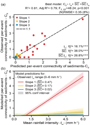
and mean (Im) rainfall intensity, and storm depth (Dp)
signif-icantly correlated with the continuity of runoff across scales (Table 2). These correlations were particularly strong for antecedent precipitation in all the analysed slope systems (0.75–0.80 for Spearman’s R). GLM modelling of observed CR values using the pool of significant event
characteris-tics (API, I15, I30, Im and Dp) pointed to the effects of
(log-transformed) API and I30variables, hillslope structural
connectivity (SC), and their corresponding interaction terms (SC : API and SC : I30) as the best model structure predictors
(R2=0.81, Adj R2=0.78 and normalized RMSE = 12 %; Fig. 5a). No additional increments of GLM complexity re-sulted in significant improvements of explained CR
vari-ance (Adj R2 values of alternative models in Table S3). The η2 values for the optimal CR model (η2; Fig. 5a)
re-vealed a primary influence of hillslope structural connectiv-ity, which absorbed 44.1 % and 16.8 % of CRvariance in the
form of direct (SC) and interaction (SC : API and SC : I30)
effects, respectively. The direct effects of the event-driven (API and I30) variables accounted for an additional 20 % of
the observed CRvariance (12.9 % and 7.1 % for API and I30,
respectively).
An increase in both antecedent precipitation and 30 min maximum rainfall intensity led to non-linear increases in runoff connectivity for all the analysed slope systems (Fig. 5b and c). CRincreased rapidly for values within 0–20 mm h−1
of maximum rainfall intensity and 0–50 mm of antecedent precipitation, tending to saturate for larger I30 and API
val-ues. However, the structural connectivity (SC) of the anal-ysed slope systems exerted a strong control on these ef-fects. Both maximum rainfall intensity and antecedent pre-cipitation increased runoff connectivity very little for Slope 2 and Slope 3, as a result of the large within-slope redistri-bution of runoff that prevailed under all rainfall conditions
Figure 5. Structural and dynamic control of patch-scale to hillslope-scale runoff connectivity: (a) best-supported model of runoff nectivity and corresponding observed-versus-predicted runoff con-nectivity values; (b) modelled I30 and SC effects on runoff
con-nectivity (API is fixed at 5.1 mm, 15th percentile of observed API values); (c) modelled API and SC effects on runoff connectivity (I30 is fixed at 3.4 mm h−1, 15th percentile of observed values).
The structure, R2, Adj R2, F statistic, p value and (normalized) root-mean-squared error of the best-supported model are detailed on top of the graph; η2values within the graph indicate the percent variance explained by the direct and interaction terms of the model. Significance:∗∗∗p <0.001;∗∗p <0.01;∗p <0.05; “ns” not sig-nificant at α = 0.05. Note that † indicates that the model takes log-transformed values for the co-variables I30 and API and that the
graphs in panels (b) and (c) show back-transformed I30 and API
values for the modelled relationships.
Table 2. Spearman’s R correlations between the event characteris-tics and conditions (storm depth, Dp; rainfall duration, Rd; 15 and 30 min maximum rainfall intensity, I15 and I30; mean rainfall
in-tensity, Im; and antecedent precipitation index, API) and the
con-nectivity of runoff and sediments for the three experimental slopes. Connectivity Connectivity of runoff – of sediments – CR CS Dp Slope 1 0.50* 0.21 ns Slope 2 0.48∗ 0.19 ns Slope 3 0.60∗∗ 0.36 ns Rd Slope 1 0.23 ns −0.23 ns Slope 2 0.18 ns −0.25 ns Slope 3 0.45∗ 0.23 ns I15 Slope 1 0.53∗∗ 0.78∗∗∗ Slope 2 0.56∗∗ 0.55∗∗ Slope 3 0.51∗ 0.39 ns I30 Slope 1 0.57∗∗ 0.73∗∗∗ Slope 2 0.61∗∗ 0.64∗∗ Slope 3 0.57∗∗ 0.43∗ Im Slope 1 0.54∗ 0.78∗∗∗ Slope 2 0.65∗∗ 0.67∗∗∗ Slope 3 0.50∗ 0.58∗∗ API (10 d, k = 0.98) Slope 1 0.79∗∗∗ 0.47∗ Slope 2 0.75∗∗∗ 0.46∗ Slope 3 0.75∗∗∗ 0.64∗∗
Significance:∗∗∗p <0.001;∗∗p <0.01;∗p <0.05; “ns” not significant atα =0.05.
Spearman’sRcorrelation values in bold are≥0.50.
for these poorly connected (SC ≤ 0.17) systems. Instead, CRstrongly increased with I30 and API for the rilled-slope
system (Slope 1), where runoff-producing low-cover areas showed a large spatial contiguity (SC = 0.47). Furthermore, antecedent precipitation had a higher impact compared to the influence of maximum rainfall intensity on runoff connectiv-ity. In fact, I30displayed a limited impact on runoff
connec-tivity under dry antecedent conditions (e.g. if API = 5.1 mm, CR in Slope 1 can increase up to ∼ 0.4 for large I30
val-ues; Fig. 5b). Nevertheless, antecedent precipitation showed an efficient capacity to increase runoff connectivity, even for moderate- and low-intensity rainfall events (e.g. if I30=
3.4 mm h−1, CRin Slope 1 may grow up to ∼ 0.8 for large
API values; Fig. 5c).
The continuity of sediment fluxes across scales (CS)
strongly correlated with mean (Im) and maximum (I15 and
I30) rainfall intensity, particularly for Slope 1 and Slope 2
(Table 2). Although considerably less intense, we also found significant correlations between CS and antecedent
precip-itation (API). GLM modelling of CS using these rainfall
variables (Im, I15, I30 and API) identified mean rainfall
in-tensity (Im), hillslope structural connectivity (SC) and their
corresponding interaction term (SC : Im) as the best model
Figure 6. Structural and dynamic control of patch-scale to hillslope-scale sediment connectivity: (a) best-supported model of sediment connectivity and corresponding observed-versus-predicted sedi-ment connectivity values; (b) modelled Imand SC effects on runoff
connectivity. The structure, R2, Adj R2, F statistic, p value and (normalized) root-mean-squared error of the best-supported model are detailed on top of the graph; η2values within the graph indicate the percent variance explained by the direct and interaction terms of the model. Significance:∗∗∗p <0.001;∗∗p <0.01;∗p <0.05; “ns” not significant at α = 0.05.
(R2=0.81, Adj R2=0.79 and normalized RMSE = 8 %; Fig. 6a). No additional increments of GLM complexity pro-duced significant improvements of explained CS variance
(Adj R2values of alternative models in Table S4). Similarly to the best CRmodel, the η2values for the optimal CSmodel
indicated a key influence of hillslope structural connectiv-ity, which explained 38.0 % and 26.8 % of CS variance for
its direct (SC) and interaction (SC : Im) effects, respectively
(Fig. 6a). The direct effect of mean rainfall intensity ex-plained an additional 16.1 % of the observed CSvariance.
CSincreased linearly with mean rainfall intensity (Im) for
the three experimental slopes (Fig. 6b). However, the impact of rainfall intensity on the patch-scale to hillslope-scale con-tinuity of sediment fluxes was highly dependent on the struc-tural connectivity of these slope systems. For Slope 2 and Slope 3, with poorly connected low-cover areas that act as sediment sources (SC ≤ 0.17), increases of rainfall intensity along the observed Im range (0–6 mm h−1) resulted in very
small increases in sediment connectivity, pointing to a large within-slope redistribution of sediments for all the explored
rainfall conditions. In stark contrast, for Slope 1, with a well-developed rill network that provides good structural con-nectivity of low-cover areas (SC = 0.47) and within-slope conditions for channel incision, CS largely increased over 1
along the range of observed mean rainfall intensities, there-fore reflecting large increases of unit-area sediment yield from the patch to the hillslope scales under high-intensity rainfall.
4 Discussion
Connectivity and scaling are key aspects for the under-standing of hydrological and geomorphological processes in the continuum from small plots to hillslopes and catch-ments (Bracken and Croke, 2007; Sidle et al., 2017). In this study we shift from the very active, present concep-tual discussion of the connectivity theory and their de-rived hydro-geomorphic study approaches (Wainwright et al., 2011; Bracken et al., 2013; Okin et al., 2015; Heckmann et al., 2018; Keesstra et al., 2018; Saco et al., 2020) to the practical application of the concepts of structural and func-tional connectivity for the analysis of the surface-patch to hillslope continuity of runoff and sediment fluxes in Mediter-ranean dry RMSSs.
4.1 Structural connectivity: organization of vegetation patterns and rill networks
Both vegetation distribution, which largely influences the spatial organization of patch hydro-sedimentary behaviour, and surface topography, which controls water and sediment flow direction, represent the major determinants for the po-tential transfer of water and sediments in the flow-path-based approach of structural connectivity applied in our study. Dry-land vegetation is frequently organized in patches, ranging from barely to densely covered surfaces, which interact as interconnected source and sink areas of runoff and sediments (Puigdefabregas, 2005; Saco et al., 2020). This source and sink behaviour largely controls the within-slope retention of water and soil resources and has been extensively described as a key structural control for the production and routing of runoff and sediments in both natural Mediterranean semi-arid landscapes (Puigdefabregas et al., 1999; Cammeraat, 2004; Arnau-Rosalen et al., 2008; Mayor et al., 2011) and reclaimed Mediterranean dry systems (Moreno-de-las-Heras et al., 2009; Merino-Martín et al., 2012b, 2015; Espigares et al., 2013). Our results reveal that the hillslope position of densely vegetated patches is a significant factor affect-ing the structural connectivity of the analysed reclaimed slope systems. In our study, the preferential concentration of densely vegetated, sink patches in the middle and lower sections of Slope 3 considerably reduces the connectivity of source areas as compared to Slope 2, where the bottom of the slope is dominated mainly by poorly covered areas
(Fig. 3b–d). These results agree with other empirical studies in the Mediterranean region that indicate that the presence of dense vegetation in and near the lower sections of plots and hillslopes provides a strong structural control for runoff and sediment delivery (Bautista et al., 2007; Boix-Fayos et al., 2007).
Our analysis of the structural components of connectivity suggests that rill networks are key elements for the transfer of water runoff and sediments. The densely developed rill net-work of Slope 1 acts as a dominant, primary factor enhancing the spatial contiguity between the barely covered, source ar-eas distributed along the hillslope and the outlet of the exper-imental slope, very largely increasing the structural connec-tivity of the system (Fig. 3a and d). In fact, rill networks pro-vide very efficient erosive flow-routing pathways that largely facilitate the transference of water and sediments across sec-tions of the hillslopes with little or no potential for runoff re-infiltration and sediment deposition (Nicolau, 2002; Bracken and Crocke, 2007; Moreno-de-las-Heras et al., 2010; Wester et al., 2014; Lu et al., 2019).
4.2 Functional connectivity: formation of connected runoff and sediment fluxes
Rainfall characteristics and antecedent conditions dynami-cally interact with the range of structural elements of the hillslopes to enable or enhance connected flow. Our analy-sis reveals that maximum rainfall intensity and antecedent precipitation are the most relevant storm event factors pro-viding dynamic control of surface-patch to hillslope conti-nuity (or functional connectivity) of runoff (Fig. 5). Both maximum rainfall intensity and antecedent moisture con-ditions are commonly perceived as the main rainfall fac-tors involved in the generation of runoff in Mediterranean landscapes (Calvo-Cases et al., 2003; Castillo et al., 2003; Cammeraat, 2004; Cantón et al., 2011; Mayor et al., 2011; Marchamalo et al., 2016; Martínez-Murillo et al., 2018; Rodríguez-Caballero et al., 2014). Infiltration-excess runoff triggered by high-intensity rainfall typically dominates the hydrological responses of Mediterranean hillslopes under dry conditions. Saturation-excess runoff may also occur in Mediterranean dry hillslopes, particularly on soils previously wetted by antecedent rainfall, inducing saturation of the top layer of the soil profile with moderate-intensity precipitation (Martínez-Mena et al., 1998; Puigdefabregas et al., 1999; Calvo-Cases et al., 2003; Castillo et al., 2003). The poor soil development conditions that characterize our reclaimed study sites may facilitate these two runoff generation mech-anisms (Nicolau and Asensio, 2000; Moreno-de-las-Heras, 2009). Whilst rapid formation of surface crusts in barely cov-ered patches of these reclaimed soils can largely facilitate the formation of infiltration-excess runoff, the massive structure of the soils, particularly in intermediate to deep layers show-ing moderate- to low-vegetation root activity, can also facili-tate the formation of runoff from the temporary saturation of
the top (5–20 cm) soil layer (Nicolau, 2002; Moreno-de-las-Heras et al., 2011a).
Our results also indicate a higher efficiency of antecedent precipitation than maximum rainfall intensity in providing conditions for the generation of patch-scale to hillslope-scale runoff continuity (Fig. 5b and c). Similarly, other Mediter-ranean dry hillslope and catchment studies have highlighted the primary role of antecedent precipitation on establishing spatial continuity in the generation and routing of runoff (Puigdefabregas et al., 1999; Fitzjohn et al., 1998; Boix-Fayos et al., 2007; Marchamalo et al., 2016). Under dry an-tecedent conditions, runoff generation is spatially heteroge-neous due to the fine-scale spatial variation of infiltration ca-pacity. This variability is generated by both patchy vegeta-tion and soil variability, which promote large discontinuities in hydrological pathways inducing spatial isolation of runoff-producing areas (Calvo-Cases et al., 2003; Boix-Fayos et al., 2007). In contrast, wet conditions reduce soil infiltration ca-pacity (Cerdà, 1997; Moreno-de-las-Heras et al., 2009) and blur the spatial variation in hydrological properties by facil-itating the formation of runoff from the saturation of the top and subsoil layers (Puigdefabregas et al., 1999; Calvo-Cases et al., 2003), thus resulting in the increased spatial continu-ity of active hydrological pathways for both the generation of runoff and the transference of water among scales and ele-ments of the landscapes (Fitzjohn et al., 1998; Boix-Fayos et al., 2007; Marchamalo et al., 2016). Our results suggest that 30–50 mm of precipitation accumulated over an antecedent period of 10 d can notably enhance the hydrological connec-tivity in our study slopes (Fig. 5c). These conditions mainly take place in the area during the autumn and spring seasons. The structural connectivity of the studied slope systems largely controls the functional connectivity of the runoff responses to rainfall intensity and antecedent precipitation (Fig. 5b and c). In contrast to Slope 2 and Slope 3, where the low spatial contiguity of runoff source areas strongly lim-its the impact of rainfall conditions on runoff connectivity, the surface-patch to hillslope continuity of runoff is highly sensitive to rainfall intensity and antecedent precipitation in Slope 1. The presence of a well-developed rill network in this slope strongly increases the structural connectivity of the system and provides a very efficient, preferential path-way for the routing of runoff. Modelling results by Reaney et al. (2014) explain the high efficiency of rill networks in the transmission of runoff as a function of their effects on transfer distances. Overall, rills operate as channels that re-duce transfer distances in relation to effective contributing area, resulting in enhanced runoff transmission along the hill-slope by an increased flow velocity and reduced length to flow concentration. In this study, the high runoff transmis-sion efficiency of the rill networks can be illustrated by the resulting cross-scale runoff continuity responses observed in the experimental slopes during the most extremely connected events (top CRwhisker values in Fig. 4c), recorded in early
moderate intensities occurring under wet antecedent condi-tions (∼ 50 mm depth, 7–9 mm h−1I30and 35–45 mm API).
In such conditions, the high runoff transmission efficiency of the rill network in Slope 1 results in the complete transfer-ence of patch-scale generated runoff to the outlet of the sys-tem, largely differing from the poorly established hydrolog-ical connectivity of the two non-rilled slopes, where 60 %– 70 % of path-scale runoff is re-infiltrated downslope before reaching the outlet.
Besides the key influence of rills for the spatial transmis-sion of runoff, these hillslope structural elements were also found to play a dominant role in the generation of sediment fluxes and its spatial distribution. Overall, our experimental slopes display two contrasting sedimentological behaviours that can be compared in light of our sediment connectivity re-sults (Fig. 4b and d). While the two non-rilled slopes (Slope 2 and Slope 3) show, for all the events analysed, poorly con-nected sediment flows characterized by important sediment deposition between the surface-patch and hillslope scales, sediment yield can very largely increase (i.e. up to 5 times) with scale for the rilled system (Slope 1) when active rill incision takes place. Similarly, other studies carried out in Mediterranean landscapes indicate that sediment yield gen-erally decreases from the small-plot to the hillslope scales in the absence of rills due to the loss of runoff by downslope re-infiltration, while soil loss per unit area generally increases with plot length when rill erosion processes prevail (Boix-Fayos et al., 2006; Bargarello and Ferro, 2010; Moreno-de-las-Heras et al., 2010; Cantón et al., 2011; Bargarello et al., 2018). In fact, runoff convergence in the rill networks pro-vides these erosive elements with the capacity to produce very important amounts of sediments, frequently resulting in significant increases in sediment yield with slope length (Giménez and Govers, 2001; Govers et al., 2007; Moreno-de-las-Heras et al., 2011b; Wester et al., 2014; Lu et al., 2019). In this context, rills not only facilitate the within-slope trans-ference of water and sediment fluxes but also work as pow-erful sources of sediments that can significantly contribute with freshly eroded particles to the analysed sediment fluxes between the surface-patch and hillslope scales.
Rainfall intensity emerges as the main storm property controlling the spatial continuity and scaling of sediment fluxes in our study slopes, particularly for the rilled system (Slope 1), where the ratio of hillslope to surface-patch sed-iment production (or functional connectivity of sedsed-iments) strongly increases with mean rainfall intensity (Fig. 6b). In Mediterranean hillslopes, storm intensity provides direct control on splash erosion and largely influences – through runoff production and concentration – the processes of sheet wash, sediment transport, and both rill and gully incision (Bargarello and Ferro, 2010; Moreno-de-las-Heras et al., 2010; Mayor et al., 2011; Cantón et al., 2011; Gallart et al., 2013). These links are frequently identified in the form of strong linear correlations between sediment yield and maxi-mum (e.g. I5, I15and I30) rainfall intensity (e.g. Cammeraat,
2004; Rodríguez-Caballero et al., 2014). In the present study, sediment connectivity is better explained by mean rainfall in-tensity (Im), which may suggest enhanced conditions for
sed-iment transfer and rill incision by sustained (rather than max-imum) high-intensity rainfall. However, the high correlation that links the maximum (I30) and mean (Im) rainfall
inten-sities of the analysed events (Pearson’s R = 0.92; p < 0.01) reveals that the storms displaying the best conditions for the formation of spatially connected sediment flows along the study period (top CS whisker values in Fig. 4d) were
char-acterized by both high maximum and averaged rainfall in-tensity (up to 33 and 6 mm h−1for I30and Im, respectively).
These enhanced conditions for the production and routing of sediments were recorded during the summer season, in the form of high-intensity convective rainfall. Previous erosion research in this experimental site has highlighted the erosive capacity of late-spring and summer convective storms, which are responsible for up to 80% of annual soil loss in the area (Nicolau, 1992; Moreno-de-las-Heras et al., 2010; Merino-Martín et al., 2012a).
The frequently observed presence of thresholds and the non-linear character of landscape hydro-geomorphological responses are to a large extent related to the runoff and sed-iment connectivity that are responsible for transferring sur-face fluxes of resources from the small-plot and sursur-face- surface-patch scales to broader hillslope and catchment scales (Puigdefabregas et al., 1999; Cammeraat, 2004; Bracken and Croke, 2007; Wainwright et al., 2011; Moreno-de-las-Heras et al., 2012; Sidle et al., 2017). Evidence of these dynam-ics is provided in this work by the non-linear relationships that link within-slope (functional) connectivity of runoff and sediment fluxes with the runoff coefficients and soil losses observed in the studied systems at the hillslope scale (Fig. 4e and f). Particularly, the critical loss of the capacity for redis-tributing surface fluxes by runoff re-infiltration and sediment deposition mechanisms in the analysed slope systems results in very large increases in hillslope-scale runoff production and soil loss. These non-linear hydro-geomorphological re-sponses are strongly conditioned by the dynamics of Slope 1, where the presence of a well-organized rill network provides the system with cross-scale hillslope structural elements for intensive sediment production and effective flow routing.
Substantial increases in functional connectivity can dy-namically feed back into the structural aspects of connec-tivity by modifying the spatial organization of preferential flow paths for the production and transmission of runoff and sediments (Turnbull et al., 2008; Wainwright et al., 2011; Okin et al., 2015; Turnbull and Wainwright, 2019). Struc-tural connectivity is perceived in our study as a static prop-erty of the explored systems during the entire period of anal-ysis (October 2007 to December 2008), which took place after 20 years of landscape evolution from the initial slope reclamation stage. Changes in structural connectivity of these Mediterranean dry human-made systems can be particularly important during earlier stages (first 5–10 years) of landscape
evolution, when the spatial arrangement and redistribution of runoff and sediment fluxes largely shape the initial estab-lishment and further dynamics of both vegetation patterns and rill networks (Nicolau and Asensio, 2000; Moreno-de-las-Heras et al., 2011b). In fact, the rill network of Slope 1 represents a key factor determining the high structural con-nectivity of this system, but its own existence can be at-tributed to the development of high levels of (runoff and sedi-ment) functional connectivity during the early stages of land-scape evolution. Spatially explicit modelling frameworks of co-evolving landforms and vegetation patterns (e.g. Saco et al., 2020) may facilitate further exploration of the long-term dynamic feedbacks that link functional and structural con-nectivity.
5 Conclusions
We developed in this study a practical application of the con-ceptual elements of structural and functional connectivity for the analysis of the surface-patch to hillslope transmission of runoff and sediments in three Mediterranean dry reclaimed mining slope systems showing different levels of long-term development of vegetation and rill networks. Our results re-vealed an important role of the hillslope position of vegeta-tion patches on the distribuvegeta-tion of potential runoff and sedi-ment flow paths. More critically, the rill networks emerged as key elements of structural connectivity in the slopes, provid-ing preferential pathways that dominate the production, spa-tial organization and routing of the fluxes of water and sed-iments. On the other hand, both runoff and sediments were largely redistributed within the analysed slope systems in the absence of rill networks. The interactions between the struc-tural connectivity of the experimental slopes and both an-tecedent precipitation and rainfall intensity largely controlled event functional connectivity. The results showed that rain-fall intensity and, more importantly, antecedent precipitation largely increased the spatial continuity of runoff fluxes un-der rilled-slope conditions, where active rill incision unun-der high-intensity rainfall induced large non-linear increases in hillslope-scale sediment yield.
In sum, this study provides empirical evidence of the fea-sibility of using the hydrological-connectivity concept for practical applications, specifically remarking on its useful-ness for understanding how hillslope structural elements dy-namically interact with storm characteristics and rainfall con-ditions to generate spatially continuous runoff and sediment fluxes. Overall, our study approach of structural and func-tional connectivity offers a useful framework for assessing the complex links and controlling factors that regulate the generation and movement of runoff and sediments across dif-ferent scales and elements of the landscape in Mediterranean dry and other water-limited environments.
Data availability. The full hydro-sedimentary and precipitation data applied in this study can be found in Table S2. Other associated data are available upon request.
Supplement. This online supplement contains complementary in-formation on general site characteristics (Table S1), the rainfall and hydrological data records of the analysed events (Table S2), the full model configurations applied for the analysis of runoff and sediment connectivity (Tables S3 and S4, respectively), and supplementary details on the parameterization of the antecedent precipitation in-dex (API) applied in this study (Sect. S1). The supplement related to this article is available online at: https://doi.org/10.5194/hess-24-2855-2020-supplement.
Author contributions. All the authors participated in the design of the study. LMM obtained the field data, with contributions from MMdlH, JMN and TE. Data preprocessing and analysis was performed by MMdlH and LMM. MMdlH led the writing of the paper, with significant contributions from all co-authors.
Competing interests. The authors declare that they have no conflict of interest.
Acknowledgements. Mariano Moreno-de-las-Heras acknowledges support from The University of Newcastle (Australia) through an International Research Visit fellowship developed in summer 2017 that facilitated the initial discussion and further development of this study. The field collection of the runoff and sediment yield data used in this study was supported by a PhD scholarship awarded to Luis Merino-Martín by the University of Alcalá. We are grateful to the Spanish National Geographical Institute and particularly to Juan M. Rodriguez, for granting us access to the PNOA aerial im-ages for this study. We thank José A. Merino for his help in the development of the topographical field survey and DEM associated products and Jesús Romero for language corrections. We also thank two anonymous reviewers for their thoughtful comments on a pre-vious version of this study.
Financial support. This research has been supported by the Ministerio de Ciencia, Innovación y Universidades (Spain) (grant nos. IJC-2015-26463 and CGL2010-21754-C02-02), the Australian Research Council (grant no. DP140104178) and the Comunidad Autónoma de Madrid (Spain) (grant no. S2009AMB-1783). We acknowledge support of the publication fee by the CSIC Open Access Publication Support Initiative through its Unit of Information Resources for Research (URICI).
Review statement. This paper was edited by Erwin Zehe and re-viewed by two anonymous referees.