Publisher’s version / Version de l'éditeur:
Recent Development of Offshore Engineering in Cold Regions, 2, pp. 695-704, 2007
READ THESE TERMS AND CONDITIONS CAREFULLY BEFORE USING THIS WEBSITE.
https://nrc-publications.canada.ca/eng/copyright
Vous avez des questions? Nous pouvons vous aider. Pour communiquer directement avec un auteur, consultez la
première page de la revue dans laquelle son article a été publié afin de trouver ses coordonnées. Si vous n’arrivez pas à les repérer, communiquez avec nous à PublicationsArchive-ArchivesPublications@nrc-cnrc.gc.ca.
Questions? Contact the NRC Publications Archive team at
PublicationsArchive-ArchivesPublications@nrc-cnrc.gc.ca. If you wish to email the authors directly, please see the first page of the publication for their contact information.
NRC Publications Archive
Archives des publications du CNRC
This publication could be one of several versions: author’s original, accepted manuscript or the publisher’s version. / La version de cette publication peut être l’une des suivantes : la version prépublication de l’auteur, la version acceptée du manuscrit ou la version de l’éditeur.
Access and use of this website and the material on it are subject to the Terms and Conditions set forth at
Survey of Canadian Arctic captains: current status and research needs
Timco, G. W.; Gorman, R.
https://publications-cnrc.canada.ca/fra/droits
L’accès à ce site Web et l’utilisation de son contenu sont assujettis aux conditions présentées dans le site LISEZ CES CONDITIONS ATTENTIVEMENT AVANT D’UTILISER CE SITE WEB.
NRC Publications Record / Notice d'Archives des publications de CNRC:
https://nrc-publications.canada.ca/eng/view/object/?id=f6962d90-f2f4-47ef-9b8a-cd8efad2f8f9 https://publications-cnrc.canada.ca/fra/voir/objet/?id=f6962d90-f2f4-47ef-9b8a-cd8efad2f8f9
695
Recent Development of Offshore Engineering in Cold Regions, Yue (ed.) POAC-07, Dalian, China, June 27-30, 2007.
@ 2007 Dalian University of Technology Press, Dalian, ISBN 978-7-5611-3631-7
SURVEY OF CANADIAN ARCTIC CAPTAINS:
CURRENT STATUS AND RESEARCH NEEDS
G.W. Timco1 and R. Gorman2
(1. Canadian Hydraulics Centre, Naional Research Council of Canada, Ottawa, Canada; 2. Enfotec, Montreal, PQ, Canada)
ABSTRACT
A survey was made of fourteen Captains of Canadian vessels that operate in Canada’s Arctic to extract their thoughts on the current status of operating in the Arctic and to help identify research needs. There was an overwhelming consensus that research on identifying multi-year ice was the top priority. Predictions of ice movement and ice pressure, and locations of large leads or polynya were also identified as important. There was a wide range of disparity on the amount of ice information that they receive on the Bridge of the vessel. There was a general consensus that improvements in interpretation of satellite imagery and better local detection of multi-year ice were top priorities.
INTRODUCTION
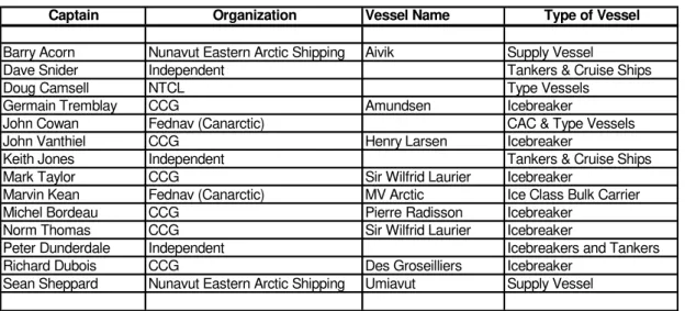
Marine transportation in the Canadian Arctic is hampered by heavy ice conditions such that no ships enter this region during the winter months. During the summer, there are a number of vessels in the Canadian Arctic including commercial vessels (both bulk carriers and ships re-supplying northern communities), tourism ships, and Canadian Coast Guard (CCG) icebreakers. As part of an overall project to review marine transportation in the Arctic (Timco et al., 2005), the authors have conducted a survey of Captains of vessels that travel to the Canadian Arctic. The intent was to identify the research needs that should be addressed to improve safety and efficiency of marine transportation in the Arctic. Since the authors have considerable experience with Arctic shipping operations, a list of potential Captains to be interviewed was developed (see Table 1). In addition, it was felt that to get a balanced approach for
696
discussions with the Captains, a set of interview questions were developed. The questions covered four basic topics as follows:
z Ice Parameters of Interest:
Specifically, what is the type and arrangement of ice that gives you the most concern for the operation of your vessel? That is, what is the range of ice conditions that you are looking to avoid?
z Sources of Ice Information
Where do you get ice information while onboard your vessel? How do you display and use ice information on your ship?
z Present Day Situation
Is the ice information you presently receive adequate and sufficiently detailed for each of the ice types that are a concern for you?
If not, what type and level of detail (i.e. very local, regional, satellite imagery, etc.) would you like to receive?
How frequently would you like to get an ice information update? How far in advance do you plan your route?
Have you had a situation where better ice information would have been useful?
z View to the future
Where would you like to see efforts placed toward improving ice information?
Do you have any ideas on what technologies should be pursued to improve ice navigation (the emphasis being on new technology for extended season operation in Arctic waters)?
During the interviews, the Captains were asked to answer the questions as a Captain of a large tanker in year-round operation in the High Arctic. This, however, was difficult for many of them and many of the responses reflect their current operational procedures. Thus, in the analysis of the responses, this aspect must be considered. This paper presents the results of this survey.
697
Table 1 List of Captains Interviewed
Captain Organization Vessel Name Type of Vessel
Barry Acorn Nunavut Eastern Arctic Shipping Aivik Supply Vessel
Dave Snider Independent Tankers & Cruise Ships Doug Camsell NTCL Type Vessels
Germain Tremblay CCG Amundsen Icebreaker
John Cowan Fednav (Canarctic) CAC & Type Vessels John Vanthiel CCG Henry Larsen Icebreaker
Keith Jones Independent Tankers & Cruise Ships Mark Taylor CCG Sir Wilfrid Laurier Icebreaker
Marvin Kean Fednav (Canarctic) MV Arctic Ice Class Bulk Carrier Michel Bordeau CCG Pierre Radisson Icebreaker
Norm Thomas CCG Sir Wilfrid Laurier Icebreaker
Peter Dunderdale Independent Icebreakers and Tankers Richard Dubois CCG Des Groseilliers Icebreaker
Sean Sheppard Nunavut Eastern Arctic Shipping Umiavut Supply Vessel
ICE PARAMETERS OF INTEREST
There were a number of ice parameters identified by the Captains. In all cases, multi-year (MY) ice was identified as the key ice parameter. Following that, ice pressure, high ice concentration and ridging were identified by about one-half of the respondents. Other factors that were mentioned include growlers and bergy bits, floe size, first-year ice and knowledge of ice decay. Fig. 1 shows a summary of the results. It is clear that multi-year (old) ice is the key ice parameter of interest in the Canadian Arctic.
0 10 20 30 40 50 60 70 80 90 100
Parameter Identified (%)
Multi-year (Old) ice Ice Pressure High Concentrations Ridging Floe Size First-Year Ice Growlers & Bergy Bits State of MY Ice Decay
698
SOURCES OF ICE INFORMATION
The Captains who were interviewed were a mix from CCG and Industry. The CCG receives excellent information from the Canadian Ice Service. They usually have an Ice Service Specialist (ISS) onboard and they use their own software package (IceVu) to display the information. This includes ice charts and RADARSAT imagery. In Industry, there were two types of ice information systems ─ some operators use the Enfotec IceNav system (Gorman and Zagon, 2005) and others use basic Ice Charts and radio communication. In total, about one quarter of those interviewed fall into the latter category. The survey is not representative of the general marine population however, since most marine operators in the north do not use a computer-based ice navigation system such as IceVu or IceNav.
The response to the Sources of Information included a wide range of sources. Fig. 2 shows the sources and the number of times that they were mentioned. The Ice Charts were used by virtually everyone and many Captains mentioned the use of satellite imagery. It is interesting to note that only a few Captains mentioned marine radar and “looking out the window” as a source of information. Since these are two sources that are constantly used, it suggests that the Captains were answering the questions with a “bigger picture” in mind (i.e. thinking about external sources of information).
0 10 20 30 40 50 60 70 80 90 100
Parameter Identified (%)
Iqualuit radio station Marine radar Ice Models Looking out the window Helicopter Canice3 aircraft Communication aids (radio) Other satellites RADARSAT Ice Charts
Fig.2 Results of the survey regarding the sources of ice information
PRESENT DAY SITUATION
There was a wide range of responses with respect to the present day situation. This could readily be categorized according to the availability of geo-referenced ice information. In general, the CCG Captains were relatively happy with the ice information, whereas some Industry Captains who did not have access to the
699
RADARSAT imagery expressed much less enthusiasm for the present day situation. Everyone stated that they would like to have more information with better resolution. There were a number of comments regarding RADARSAT. Although the Captains felt that it was good, there was some concern that it needed to be ground-truthed better. Also there were comments for higher resolution and more flexibility on choosing where images should be taken (i.e. because of the long lead time required to order an image). A large number of Captains commented that they would like to have more access to the images.
Some Captains mentioned that the current ice information for multi-year ice is not done properly. There are instances where multi-year ice occurred in regions where the Ice Charts indicated no MY ice.
A number of Captains mentioned that old ice information is useless. Some mentioned that they sometimes wait for the new information before proceeding if they are unsure of the ice situation.
There were several other factors mentioned including:
z More information on pressured regions would be desirable z More detail in specific regions (e.g. passageways and ports) z Identifying bergy bits & growlers
z The poor quality of the Ice Charts that are received by fax z The lack of charts with forecasts
z Sometimes no Ice Charts are available (they tend to follow the CCG vessels)
VIEW TO THE FUTURE
All Captains wanted more information. There was a recurring theme that navigators wanted an integration of satellite imagery with meteorological and oceanographic (winds and currents) for predictions of ice movement. Many expressed a desire to have more access to the raw data and not simply a chart processed by someone ashore. A number of Captains indicated that a system for detecting multi-year ice and small glacial ice locally would be very beneficial to them.
There were a number of specific points raised by the Captains. The overall theme of their comments indicated that they would like to see new technology that is affordable with proper training on how to use it. They also wanted higher resolution of the satellite imagery and more raw data on the Bridge so that they could do their own analysis. They also indicated a desire for a system for locally detecting hazardous ice and better predictions of ice drift and pressure ice conditions. Since
700
there were a wide range of suggestions, some general and some quite specific, it is instructive to look at each of them as listed below. Note that these comments have been reprinted here without editing:
z Being able to receive more information.
z Would like to see RADARSAT images with an overlay of wind and current vectors showing predicted drift of the ice. Showing the areas where pressure may be encountered in the future.
z Emphasis on improving existing technology such as RADARSAT and marine radar, such as the IceNav system with the radar interface.
z Emphasis on developing user friendly systems that can be used by the navigation officers.
z The integration of RADARSAT and ice chart data with ECDIS would be very valuable.
z Important point is whatever is developed must be affordable.
z The best product we would like to see is an image with a chart overlay on the image so we can have both the interpretation as well as be able to actually see the imagery at the same time.
z Don’t place much value on a forecast or models as the accuracy is in question. Predictions for 12 to 24 hours maybe but won’t have much faith in a forecast beyond this.
z Training in ice navigation and the use of ice information will be critical. You can develop all the nice technology you can but if no one knows how to use it, it will all be for naught.
z Not much credence on model outputs now. Not my first priority for future research.
z Cross-polarized radar technology holds the best promise for the future for the detection of bergy bits and growlers in front of the vessel.
z Multi-year ice would be first since avoidance of potential damage must be rated as No. 1 issue. This could also apply to glacial ice (depending upon the location in the Arctic).
z Pressure is another one. However, being stuck in pressure would slow things but would not be catastrophic.
z Has the use of sonar been properly investigated? Can you mount one in the bow looking up for ½ mile to see if anything deep-keeled is in the way?
701
z Making satellite imagery cheaper.
z More care (emphasis) on forecasting ice movement/change.
z Multi-year ice-most damage caused by inadvertently hitting a piece of multi-year ice.
z New vessel locator on electronic charts-show ship identifier such that other ship(s) can be picked out in pack ice on charts and radar.
z Always show the position of the CCG Icebreakers on the charts.
z Don’t have much faith in model forecasts. Would prefer to see images over ice charts. The egg is the average of the ice conditions in a zone but an image can give more subtle details than a chart can. Using satellite images that can improve ice type classification would be great – there is some ambiguity with RADARSAT now.
z Making the cross-polarized radar work would be very interesting. Detecting old ice and growlers in front of the vessel is still a very difficult issue.
z More ice charts per day.
z Satellite imagery that shows photographs (this depends on cloud cover).
z Better local information would be useful (with a helicopter if available).
z System to detect ice that could cause damage in low ice conditions. (e.g. some type of radar system).
z Ice information is good today for our present mode of operation but it would not be adequate for year-round shipping in the Arctic.
z Daily ice charts as a minimum based on as close to real time info as possible. Chart accompanied by actual RADARSAT imagery in resolution that allows for identification of floes to 50 metres as a minimum. Real time is very important, the gap between RADARSAT passes that occurs at present is insufficient to meet changing operational needs of Arctic research ships.
z Better resolution radar satellite imagery. MODIS images I have seen are excellent but at present are not timely.
z Would like to see more raw data rather than processed data (i.e. RADARSAT, weather info, etc. rather than a note from the CIS that there could be pressured ice in a certain location).
z Efforts in more detailed satellite imagery.
702
z Need to ensure that RADARSAT 1 is properly replaced with RADARSAT 2 in a timely manner.
z Need greater flexibility in being able to change requirements for obtaining satellite images areas and schedules. It appears at the moment this can be done on two weeks notice, but there is a definite reluctance
z Satellite Ice Imagery from various sources (RADARSAT, MODIS, etc) should be provided at higher resolution more frequently. Also, this same imagery along with other information could be combined to provide updated ice predictions models which could include information of ice type, thickness, growth/deterioration, movement, pressure,etc.
z Weather marine forecast: one to ten days for planning purpose.
z Better repeat coverage on the satellite data. Need much better ground truthing of satellite data. There is a lot of ambiguity in the interpretation of the imagery. Prefer an aircraft outfitted with high resolution radar that can downlink imagery directly to the vessel.
z A shipboard system that can be used by the officers would be helpful. A more user friendly system. IceVu is not a ship-specific tool, would like a ship-specific tool (taken to mean a more navigationally oriented system).
z Training of shipboard personnel very important. There is a need to have much more training in ice navigation and image interpretation than is the case at the moment.
z Liked the idea of hull sensors that tells the Captain when he is pushing the ship too much. The 1100 class is much more susceptible to damage so a system that alerts the Captain to this situation would be useful.
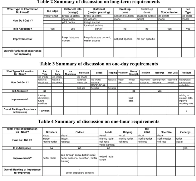
WORKSHOP
Following the interviews, a Workshop was organized in Montreal to get more input and discussion on this issue. The Workshop was held at the Fednav offices in downtown Montreal on January 19, 2005 and is summarized in Timco et al. (2005). It started with presentations on various aspects of ice information technology. Bob Gorman (Enfotec) gave an overview of ice information systems in use today, as well as some systems that were tried but were unsuccessful. John Falkingham (Canadian Ice Service) discussed the operations and products of the Canadian Ice Service. Barb O’Connell (Canadian Coast Guard) presented an overview of the ice operations onboard Canadian Coast Guard icebreakers. Garry Timco (National Research Council) provided a review of the interviews of the Captains and some general conclusions
703
drawn from them. The floor was then open for discussion.
The approach used in the discussion was to identify the current status and research needs according to:
z Long-term Requirements
z One-day Requirements (i.e. information required by the Captain regarding the ice conditions along the route planned for that day)
z One-hour Requirements (i.e. information on local ice conditions in the vicinity of the vessel).
Table 2 to Table 4 provide a summary of these discussions and the current status of knowledge of various ice parameters that are required for safe and efficient navigation for each of three time-lines.
Table 2 Summary of discussion on long-term requirements What Type of Information
Do I Need? Ice Edge
Historical Info (voyage) Historical (project planning) Break-up dates Freeze-up dates Ice Concentration Ice Type weekly chart break-up dates break-up dates seasonal outlook seasonal outlook ice charts ice chart ice atlases ice atlases model model model model pilot books image archive
ice chart archive
Is it Adequate? yes yes sort of no no yes yes
Improvements? keep database
current
keep database current,
easier access not port specific not port specific
Overall Ranking of Importance for Improving How Do I Get It?
Table 3 Summary of discussion on one-day requirements
What Type of Information Do I Need? Ice Type Ice Conc Ice
Thickness Floe Size Leads Ridging Visibility Decay/
Strength Ice Drift Icebergs Met Data Pressure
ice charts ice charts ice charts
radarsat radarsat radarsat ice charts radarsat model model met model iceberg chart observed met forecast visual obs visual obs visual obs radarsat obs obs. tidal pred. historical model tide forecast
MODIS/NOAA ice bulletin
heli obs heli obs heli obs
Is it Adequate? no no yes Improvements? training, climatology, future satellites field data training to interpret data, improve modeling tools
Overall Ranking of Importance
for Improving 1 (Old Ice) 2
How Do I Get It?
Table 4 Summary of discussion on one-hour requirements What Type of Information
Do I Need? Growlers Old Ice Leads Ridging
Ice
Conc Floe Size icebergs
visual visual visual visual visual visual
impact impact marine radar marine radar marine radar marine radar radar marine radar radarsat heli reco heli reco heli reco heli reco visual
video camera
Is it Adequate? no no no yes
Improvements? better radar
see through snow, better radar, better seasonal detection, better training
extend radar range
Overall Ranking of Importance for Improving
1 better shipboard sensors How Do I Get It?
704
SUMMARY
This study has identified three broad themes where improvements from research and development would aid Arctic transportation.
The first goal was towards improved satellite imagery and the integration of several sources of raw and processed data. There was a strong preference to receive image data in as near-real-time as possible on the vessel rather than a “processed” chart from ashore. This could be, for example, a multi-layer system which includes on different layers, a satellite image, the corresponding Ice Chart, the weather forecast, the forecast wind magnitude and direction, the regional currents, the forecasted ice movement and pressure, etc. This would allow the Captains to see both the raw and processed information. The system would have to be easy to use, inexpensive and have proper training in its use. This view was a very regional view that includes satellite information as the core.
The second goal was the development of a system that would provide better local information on multi-year ice and large ice features, especially in poor visibility situations. This system must be easy to use, inexpensive and have proper training. The third goal was to develop improved predictive methods for ice pressure and the occurrence and movement of open leads.
ACKNOWLEDGEMENTS
The authors would like to thank the Captains who participated in this survey and their Organizations (Canadian Coast Guard, Fed-Nav (Canarctic), Nunavut Eastern Shipping Company, NTCL). Funding from the Climate Change Technology and Innovation Initiative is gratefully acknowledged.
REFERENCES
Gorman, R., T. Zagon, T. (2005). Final Report – IceNav Virtual Marine Radar Integration of RADARSAT-Marine Radar. Contract report by Enfotec Technical Services for the Canadian Space Agency, Saint-Hubert, QC, Canada.
Timco, G.W., Gorman, B., Falkingham, J., B. O’Connell. (2005). Scoping Study: Ice Information Requirements for Marine Transportation of Natural Gas from the High Arctic. NRC Report CHC-TR-020, Ottawa, Ont., Canada.