by
Noah P. Snyder
B.S. Geology Bates College, 1993
SUBMITTED TO THE DEPARTMENT OF EARTH, ATMOSPHERIC, AND
PLANETARY SCIENCES IN PARTIAL FULFILLMENT OF THE REQUIREMENTS FOR THE DEGREE OF
DOCTOR OF PHILOSOPHY
AT THE
MASSACHUSETTS INSTITUTE OF TECHNOLOGY
SEPTEMBER 2001
© 2001 Massachusetts Institute of Technology. All rights reserved.
Signature of Author:
Certified by:
Accepted by:
Department of Earth, Atmospheric, and Planetary Sciences June 29, 2001 Kelin X Whipple Thesis Supervisor Ronald G. Prinn Department Head OF MU0 G1 LIBRARIE
-U*wl
Noah P. Snyder
Submitted to the Department of Earth, Atmospheric, and Planetary Sciences on June 29, 2001 in Partial Fulfillment of the Requirements for the Degree of Doctor of Philosophy in Geology.
Abstract
The response of bedrock channels to external forcings is investigated in this thesis. The approach is to test and constrain a theoretical model for bedrock-channel incision based on shear stress using field data. The primary study area is a series of 21 small, coastal drainage basins in northern California, USA with known, varying rates and history of rock uplift. The initial
application of a simple form of the model to the stream profiles suggests that (1) the channels are eroding at rates approximately equal to uplift rates (i.e. steady-state fluvial incision), and (2) erosion processes are proportionally more effective in the high-uplift-rate zone, with factors in addition to channel gradient responding to tectonic forcing. These results lead to the rest of the study, in which some of the assumptions of the simple model are rejected in order to explain the second observation. A more sophisticated model that includes both a stochastic distribution of floods and a threshold shear stress to initiate bedrock erosion (s) predicts that a greater part of the distribution of flood events will exceed the threshold in steeper channels. Therefore, higher-gradient channels have proportionally higher erosion rates, as is observed in the high-uplift-rate streams of the California field site.
The shear-stress model is tested and constrained through a detailed, field-based analysis of topography, lithology, stream morphology and regional hydrology to isolate those factors that respond to tectonics. The stochastic model is able to incorporate the observed variation in stream discharge due to orographic enhancement of precipitation by high topography associated with high uplift rates. This increase in discharge appears to play a second-order role in setting the erosional effectiveness of the high-uplift zone. Other factors, including channel width, lithologic resistance and sediment flux, do not appear to vary in an important way with uplift rate, although this conclusion is based on analyses that have some limitations. The importance of thresholds is
underscored by a direct calculation of critical shear stress during a rare bedrock-incision event in a low-erosion-rate creek in New York state (r~100-200 Pa). This event, the only one that caused
rate, with few events that exceed the threshold. In contrast, similar ze values are exceeded during high-frequency flood events in the steep, rapidly eroding California streams. Inclusion of an
erosion threshold accounts for the observed relationship between channel gradient and rock-uplift rate in the California site. In summary, by using field examples, the shear-stress bedrock-incision model with a stochastic distribution of flood events and an erosion threshold is
demonstrated to be an effective and powerful tool for exploring relationships amongst climatic, tectonic and surficial processes.
In the final section of this thesis, a numerical modeling study couples the shear-stress model for onshore fluvial incision with a simple rule for offshore wave-based erosion of bedrock to explore the response of uplifting streams to eustatic fluctuations. The results highlight the importance of offshore boundary conditions to the onshore response, particularly the position of the edge of the uplifting block and the development of bathymetry. A comparison of model results with the northern California channels suggests that (1) the steady-state hypothesis is consistent with an offshore decrease in rock-uplift rates, and (2) the ubiquitous low-gradient, alluviated mouths of the study-area streams are predicted by the model during uplift of the offshore platform during the late Holocene sea-level stillstand.
First, I wish to thank Kelin Whipple, my advisor. His accessibility, enthusiasm and faith made my graduate-school experience fun and enriching. I will always harbor a certain amount of pride for being the first person to start and finish on the Whipple program. All along I have felt that I am playing for Team Whipple, although my perceived role has changed through the years: early on I thought of myself as a utility infielder always ready to put down the sacrifice bunt to help out the team, and now I'm more of a grumpy veteran trying to pad my batting statistics!
I also very much appreciate the help and guidance provided me by Dorothy Merritts and Greg
Tucker, who have been collaborators and advisors to this thesis work. I express my gratitude to the other members of my thesis committee, Kip Hodges, John Southard and Rafael Bras for their guidance and suggestions along the way. I also thank professors John Grotzinger, Clark
Burchfiel, Wiki Royden and Eric Leonard.
Next, I express my love and thanks to Lydia Bergen who has put up with me for pretty much the whole run at MIT. She deserves as much credit as anyone for making this thesis happen. Her devotion and support have been the greatest source of inspiration and renewal over the past 5
years. We've been through a lot together, and I can't wait to see where we go next!
I want to mention the series of teachers who put me on this path. Dan Flerlage at the Alternative
Community School in Ithaca instilled my initial interest in field science. Professors Dyk Eusden and Mike Retelle at Bates College drew me into the geologist fold and laid my geological foundation, as did Ken Fink, John Creasy and Marita Bryant. I also thank Lee Allison, Gary Christensen and Mike Lowe at the Utah Geological Survey. Jon Stock and Tom Dunne told me get in touch with Kelin, and vouched for his (slightly dicey) character.
At MIT, my fellow graduate students made the whole experience fun. I thank the other members of the "gang of four," Eric Kirby, Arthur White, Jose Hurtado, and all of the other students (as well as postdocs) that I overlapped with, including Simon Brocklehurst, Sinan Akciz, Lindsay Schoenbohm, Mark Behn, Julie Baldwin, Mark Schmitz, Karen Viskupic, Jenny Matzel, Becky Flowers, Kirsten Nicolaysen, Anke Friedrich, Jim VanOrman, Steve Parman, Steve Singletary, Astri Kvassnes, Bill Lyons, Amy Draut, John Thurmond, Steve Dibenedetto, Marin Clark, Matt Dawson, Bridget Berquist, Matt Reuer, Frederik Simons, Eliza Richardson, Peter Dodds, Jeremy Boyce, Chris Studnicki-Gizbert, Blair Schoene, Ben Crosby, Cam Wobus, Jeff Parsons, Mike Kroll, Jahan Ramezani, Stephen Lancaster, Jeff Niemann, Daniel Collins, and Nicole Gasparini. These people taught me most of what I know now, especially about earth-science subjects outside of my primary field. I feel fortunate to have them as colleagues.
Finally, I thank my family, Laurie Snyder, John Wood, Philip Snyder, Pat Paine, Ben Snyder, Norri Paine and Jonathan Paine for their love and support from all corners of the world. Lastly, I want acknowledge the key role of my friends/housemates/ultimate teammates over the past five years, including Matt Bogyo, Becky Allen, Evan Powers, Dave Owen, Lydia, Jessica Parsons, Tom Evans, Greg Hoke, Chris Heppner and Biz Fitzsimons, for providing necessary diversions from the production of this document.
C hap ter ] Introduction ... 7
Chapter 2 Landscape response to tectonic forcing: Digital elevation analysis of stream
profiles in the Mendocino triple junction region, northern California... 19
Chapter 3 Channel response to tectonic forcing: Analysis of stream morphology and
hydrology in the Mendocino triple junction region, northern California... 33
Chapter 4 Stochastic floods and erosion thresholds in bedrock rivers: Implications for
landscape relief... 85
Chapter 5 Interactions between onshore bedrock-channel incision and nearshore wave-based erosion forced by eustasy and tectonics ... 105
1. Introduction
This thesis was motivated by growing interest within the earth science community to better understand geomorphic responses to external forcings (e.g. Molnar and England, 1990; Bull,
1991; Merritts and Ellis, 1994; Koons, 1995; Tinkler and Wohl, 1998). Bedrock rivers set the
relief structure in active mountain belts (Whipple et al., 1999), and their morphology reflects the integrated history of tectonic, climatic and eustatic fluctuations (Howard et al., 1994). At its core, this thesis is concerned with using field settings of known history to test and constrain an incision model of bedrock rivers. The fundamental goal of such work is to advance our
knowledge of fluvial response to external forcings so that geomorphologists eventually might unravel tectonic and climatic history from the record preserved in topography.
This project began with the expectation of moving beyond the popular stream-power or shear-stress models for detachment-limited bedrock incision (e.g. Howard and Kerby, 1983; Howard,
1994; Whipple and Tucker, 1999). The initial plan was to study aspects of the response of channels to an increase in rock-uplift rate, including: (1) the role of changes in channel
morphology (width, bed cover, etc.); (2) the representation of climate and climate differences in erosion models; and (3) the transient form of stream profiles. Analysis of stream longitudinal profiles in the Mendocino triple junction region of northern California, however indicated that
(1) the streams were in steady state with rock-uplift rates, and (2) the simple shear-stress model
was apparently capable of explaining the observed relationship between topography and uplift rate, provided that some feedback (morphologic, climatic, etc.) existed between uplift and incision rates. These basic observations, contained in Chapter 2, led naturally to the rest of the thesis, in which significant progress is made in understanding and modeling fluvial responses to tectonic and climatic changes. However, the project did not include the opportunity to investigate channels in a transient-response condition.
The basic form of the shear-stress model, with fluvial incision rate given by a power-law function of channel gradient and drainage area modified by a coefficient of erosion (K), comes from a simple, standard set of assumptions. Here, these assumptions are reviewed qualitatively. More complete derivations are available in Chapters 2 and 3, as well as a recent treatise by Whipple and Tucker (1999). The initial postulate of the model is that incision rate is a power-law
function of excess shear stress, or the difference between basal shear stress (zb) and a critical (or threshold) shear stress to initiate bedrock incision (r,). This approach is similar to models based on stream power (Whipple and Tucker, 1999). In the simplest case, 1b is assumed to be much greater than r, during the floods that do the work, so ir can be eliminated from the model. The next step is to place z- in terms of easily measured quantities. The assumptions of steady, uniform flow (i.e. conservation of momentum) and conservation of water mass yield the classic depth-slope product estimate of TI,. The addition of a semi-empirical bed-friction relationship (i.e. the Manning equation) yields z-b in terms of stream discharge, channel width, gradient, and a friction factor (i.e. Manning's N). The final steps are to express discharge and width in terms of drainage area, using empirical power-law relationships (e.g. Leopold and Maddock, 1953; Dunne and Leopold, 1978). These steps require the simplifying assumption that incision can be modeled using a representative flood event (i.e. bankfull) that occurs during some fraction of the time (Wolman and Miller, 1960). Most applications of the shear-stress model assume implicitly or explicitly that channels respond to tectonic perturbations solely by adjusting bed gradient
(Whipple and Tucker, 1999), not other factors such as channel width. This and most of the other assumptions outlined above are explored in this thesis, using both empirical data and theoretical arguments.
The work presented here depicts the evolution of understanding of bedrock incision in the
northern California field setting. In a sense, it represents a typical example of the application of a simple model to a complex field setting: the project begins with a set of assumptions that reduce the model to its most basic possible form (described above), and throughout the thesis
assumptions that prove unacceptable are rejected. The final product is a richer, more robust, more complicated model, which can fully explain the observed topographic-tectonic-climatic relationships. The next few pages introduce the four chapters that follow, with emphasis on critical evaluation of the application of the shear-stress model to field settings. The chapters are presented in the order in which they were originally written, which is appropriate. Chapters 2 through 4 represent a direct progression of the model predictions for response to tectonics and climate, and they lead naturally from one to the next. Chapter 5, on modeling response to eustatic forcing, is most directly an offshoot of Chapter 2, but it has important implications for the thesis as a whole.
Outline of Chapters 2-5
Chapter 2 is an analysis of the longitudinal profiles of 21 small, coastal drainage basins in the tectonically active Mendocino triple junction region of northern California. This is the primary field area of the thesis. It was chosen because the uplift rates and history are known from studies of emergent Pleistocene and Holocene marine terraces (Merritts and Bull, 1989; Merritts and Vincent, 1989; Merritts, 1996). Rock-uplift rates (U) vary from ~0.5 mm/yr in the southern part of the study area (low-uplift zone; LUZ) to ~4 mm/yr in the King Range to the north (high-uplift zone, HUZ). Merritts and co-workers found that uplift rates accelerated in the HUZ at
-100
ka. This observation led to the initial interest in the region, for it affords the opportunity to study the response of streams to a change in uplift rate, perhaps even capturing the topography in atransient state. In addition to the known uplift-rate history, the field area was well suited for this study because (1) the lithology was approximately uniform spatially, and (2) climate was
constant spatially (except known orographic effects) and temporally, although these assumptions are evaluated carefully in Chapter 3.
The stream profiles were extracted from digital elevation models (DEMs). An initial goal of the study was to compare topography from DEMs with data derived from topographic maps and field surveys, and further to develop techniques for stream-profile analysis using DEMs. The profiles themselves exhibit smooth, concave-up shapes, even in the HUZ, suggesting that the streams may be in steady state with current uplift rates. The steady-state channel hypothesis is evaluated in Chapter 2, and it is central to the rest of the study, for it permits the use of
topography to estimate shear-stress model parameters. The resulting analysis indicates that the linear version of the model can explain the observed relationship between channel slope and rock-uplift rate only if the coefficient of erosion (K) varies significantly in concert with U, with higher values in the HUZ (addressed in Chapter 3, see below). Also, the channel concavity () is constant throughout the study area, consistent with shear-stress model predictions for steady-state channels and with a preliminary channel-width dataset. The chapter closes with a
calculation of theoretical response time for the HUZ channels, which matches the field evidence from Merritts and Bull (1989) reasonably well.
Chapter 3 delves deeper into the observation from Chapter 2 that erosion processes are apparently more effective (higher K) in the HUZ. Here the central question is: what aspects of the environment and morphology are responding to uplift rate or otherwise changing between the
LUZ and HUZ? The search for an answer began with a list of four possible factors that could
explain the observed variability in K: (1) discharge-increase in the HUZ due to orographic enhancement of precipitation; (2) channel width-decrease in the HUZ as the channels entrench to more efficiently incise; (3) lithology-more resistant in the HUZ; and (4) sediment flux-higher in the HUZ and more effective as an erosive agent. These four hypothesized responses motivated a fieldwork-based effort to explore differences in each factor between the uplift-rate zones and therefore carefully constrain and evaluate the shear-stress model.
For the field-based study, the morphology and lithology of 7 streams was analyzed, as well as discharge data from 15 gauging stations throughout the region. Orographic enhancement of precipitation appears to cause an approximately twofold increase in discharge in the HUZ, which can explain part (but not all) of the apparent variation in K. Measurements of high-flow channel width indicate that streams of the LUZ are actually narrower (at a given drainage area) than those in the HUZ, counter to the hypothesized response. However, this decrease in width is likely the result of a recent (last 100 yr) land-use difference between the zones, not a long-term response. Valley width does not appear to vary significantly between the HUZ and LUZ, and it is not sensitive to land use. Measurements of rock strength and qualitative joint-spacing surveys (Selby, 1993) suggest that lithologic resistance to erosion is reasonably constant throughout the study area. Finally, observations of bed sediment are hampered by the land-use difference, so definitive statements about the influence of sediment flux on erosion rates cannot be made from the field data. Thus, of the responses hypothesized above, the first (discharge) was confirmed but too weak to explain the variability fully, the second and third (width and lithology) were
invalidated, and the fourth (sediment flux) was untestable in this landscape. However, a careful review of the model assumptions indicated that a fifth factor-the threshold for erosion of bedrock-that is usually neglected could play an important role. This chapter closes by showing that inclusion of a nonzero value for threshold shear stress (,r) in the model changes the
theoretical relationship between steady-state channel gradient and rock-uplift rate, suggesting that this term should not be omitted from the model.
In Chapter 4 the role of thresholds and stochastic processes in driving bedrock incision by rivers is examined. As mentioned above, 'z is usually omitted from modeling efforts because of the simplifying assumption that bedrock erosion occurs only during major floods that far exceed this threshold. Essentially, this omission is directly coupled to the assumption of a dominant
discharge event that does all the geomorphic work. The threshold term gains importance only if some part of a distribution of floods is able to exceed it in a given field area. This was
demonstrated by Tucker and Bras (2000), who used a model forced by a stochastic distribution of storms to show that omission of z, leads to the counterintuitive prediction that the least-variable climate yields the most rapid incision rates. Therefore, models will be most effective if they include both thresholds and a realistic distribution of the magnitude and frequency of flood events.
In the first part of Chapter 4, basal shear stress during a 1981 flood event on a New York river was calculated. This flood was the only event in the past ~40 years that caused significant plucking of in-place bedrock on the river bed, therefore the shear stress yields a maximum estimate of the threshold shear stress (r=100-200 Pa) for this setting, a difficult quantity to measure from field data. This result highlights the importance of erosion driven by discrete, rare (in low erosion-rate settings) flood events that generate shear stresses in excess of thresholds.
In the second part of Chapter 4, the more sophisticated Tucker and Bras version of the shear-stress model that includes a threshold shear shear-stress for bedrock incision and stochastic distribution of storm events (Tucker and Bras, 2000; Tucker, 2001) is applied to the northern California streams. To do this, Poisson pulse rainfall model parameters (Eagleson, 1978) were calculated for two weather-data stations to represent the climate in the LUZ and HUZ. This model indicates that a reasonable, low value of threshold shear stress (r= 100 Pa) is capable of explaining the observed relationship between channel gradient and uplift rate without need to appeal to unexplained and untestable influences, such as sediment flux. Because of the relatively high channel gradients of the California streams, this value of z, is exceeded during high-frequency events in the study area, particularly in the HUZ. Therefore, erosive events occur more often, consistent with the overall high erosion rates and the observed increase in erosional efficiency in the HUZ. This approach yields a satisfying, fully explained picture of the channel response in the northern California field site. Moreover, it underscores the importance of modeling climate with
a stochastic distribution of events (some capable of exceeding thresholds), not with a single "representative" flood event (i.e. Chapters 2 and 3).
Chapter 5 couples the shear-stress model to a simple rule for offshore wave-based erosion
(Anderson et al., 1999), to investigate how eustatic fluctuations in sea level affect onshore fluvial profiles. This work is partially motivated by a question raised in Chapter 2: can channels exhibit steady-state topography if the base level is constantly fluctuating? Two sets of experiments with the coupled erosion model were done, the first using a constant rate of sea-level rise or fall, and
the second forced by a realistic Late Quaternary sea-level curve. Systematic variations in offshore bathymetry and uplift-rate boundary conditions were used in the various runs. The model explores the interplay of four rates: sea-level change, rock-uplift, fluvial incision, and wave-based erosion. The results highlight the importance of boundary conditions in setting model response. The development of approximately constant onshore channel topography depends on the existence of a relatively stable shoreline position, for which a decrease in rock-uplift rate from onshore to offshore is generally necessary. The onshore response to sea-level regression depends critically on the bathymetry, which is developed by wave-based erosion and uplift. Further advances in this kind of modeling will require a more sophisticated model to describe wave-based erosion of bedrock. In the final analysis, the model results are compared to topographic and bathymetric profiles from the Mendocino triple junction area. Several aspects of the longitudinal profiles are consistent with model results, including the common, relatively flat, alluviated channel mouths, and the observed scatter in channel-gradient data. The model
indicates that the steady-state hypothesis for the California streams is reasonable, if the rock-uplift rates derived from onshore marine terraces decrease seaward in the nearshore.
To summarize, the structure of this thesis is to begin with a basic model (Chapter 2), test simplifying assumptions and constrain empirical internal relationships (Chapters 3 and 5), and add complexity as necessary (Chapters 4 and 5). The final picture of the Mendocino triple junction study area is a well-developed picture of channel response to tectonic, climatic and
eustatic forcings, fully informed by field and hydrologic data, and modeled using a minimum number of unconstrained parameters. Bedrock-incision modeling efforts will be most effective for rigorously testing climate-tectonic hypotheses if they are driven by a realistic suite of flood magnitude and frequency, modified by physically based erosion thresholds.
The following four chapters have been written for publication in journals, with coauthors Kelin Whipple, Gregory Tucker, and Dorothy Merritts. Chapter 2 was published in the August 2000 issue of the Geological Society ofAmerica Bulletin. Chapter 3 was submitted to Geomorphology on January 25, 2001. Chapter 4 was submitted to Nature on May 16, 2001. Chapters 3 and 4 are presently in review. Chapter 5 is intended for submission to the Journal of Geology.
Future work
Further advances in bedrock-incision modeling will depend primarily on studies in other well-chosen field sites and on laboratory experiments. Bedrock incision, unlike for instance sediment transport or mass wasting, is difficult to monitor in the field because the rates are usually slow compared to human timescales. Field-based advances generally require well-preserved strath terraces (e.g. Merritts et al., 1994; Wegmann and Pazzaglia, 1998) or other natural experiments (e.g. chapters 2-4; Stock and Montgomery, 1999; Whipple et al., 2000b). Here several avenues for further work on bedrock incision are suggested. As in this thesis, the focus is on detachment-limited incision processes, but recent studies also indicate that transport-detachment-limited incision (as well as transitions between these states) is also an important area for continued work (Willgoose et al., 1991; Howard, 1998; Sklar and Dietrich, 1998; Whipple and Tucker, 2001).
The work presented in this thesis argues strongly for a stochastically based approach to
geomorphic modeling, with inclusion of erosion thresholds. To understand this better, more field settings where bedrock erosion has occurred during discrete, historical events need to be found (e.g. Whipple et al., 2000b). Such field studies will be most successful if the events are captured
by a monitored suite of precipitation and discharge data (e.g. Chapter 4). Also, the influence of
variations in orographic precipitation (Barros and Lettenmaier, 1993) on stream discharge, both within a field area (e.g. Chapter 3), and within a drainage basin (e.g. Roe et al., 2001) must be monitored and quantified, so that this feedback can be better included in stochastic models.
A second kind of natural experiment requires areas with a demonstrable transient condition (e.g.
Stock and Montgomery, 1999; Whipple et al., 2000b), where the river profile is clearly in the process of responding to a perturbation. The best such experiment would be at a place where a
change can be constrained using precise geochronologic techniques (Noller et al., 2000). Initially, this was thought to be the case in the King Range of northern California, but analysis showed that the most likely scenario was that the streams have responded to the uplift-rate acceleration. Field settings with such transient conditions must be found (e.g. Spotila et al.,
1998) and studied from the standpoint of physics-based fluvial incision modeling. A well-dated
transient condition might yield a unique opportunity to (1) constrain all of the unknown model parameters and (2) test differing bedrock erosion models against each other.
Finally, a richer understanding of the physics of bedrock erosion is critical (e.g. Foley, 1980; Slingerland, 1997; Hancock et al., 1998; Sklar and Dietrich, 1998; Whipple et al., 2000a). This thesis concludes that a shear-stress-based model can describe the observed response, but it does little to test or constrain the fundamental relationship between fluvial fluid flow (i.e. shear stress, stream power) and bedrock erosion. As seen by the example of sediment-transport processes, the details of the physics will be best understood through well-designed laboratory experiments. Recent work by Sklar and Dietrich (Sklar and Dietrich, 1999) on bedrock erosion by impact abrasion shows great promise for understanding the critical role of sediment flux in bedrock incision (Sklar and Dietrich, 1998). Flume work by Parker and colleagues (e.g. Parker and Izumi, 2000) on knickpoint-driven incision demonstrates the importance of this process. Large-scale flume experiments on plucking of bedrock blocks may be a parallel avenue for advancement. Recent experiments of deposition in a tank where subsidence rates can be systematically varied (e.g. Hasbargen and Paola, 2000) hold immense promise for using controlled studies to unravel responses and interactions among base level, tectonics and thresholds. Of course, detailed monitoring of bedrock-erosion processes in natural channels must also be done (e.g. Hancock et al., 1998; Whipple et al., 2000a), including reoccupation of field surveys (e.g. Whipple et al.,
2000b). Until geomorphologists can develop a more complete theoretical understanding of both
the fluid processes that drive bedrock incision and how these processes are affected and changed
by factors such as lithologic resistance and sediment flux, modeling efforts will be hampered by
References cited
Anderson, R.S., Densmore, A.L., and Ellis, M.A., 1999, The generation and degradation of marine terraces: Basin Research, v. 11, p. 7-19.
Barros, A., and Lettenmaier, D., 1993, Dynamic modeling of orographically induced precipitation: Reviews of Geophysics, v. 32, p. 265-284.
Bull, W.B., 1991, Geomorphic Responses to Climatic Change, Oxford, Oxford University Press,
326 p.
Dunne, T., and Leopold, L.B., 1978, Water in Environmental Planning, New York, W.H. Freeman and Company, 818 p.
Eagleson, P.S., 1978, Climate, soil, and vegetation 2. The distribution of annual precipitation derived from observed storm frequencies: Water Resources Research, v. 14, p. 713-721. Foley, M.G., 1980, Bed-rock incision by streams: Geological Society of America Bulletin, Part
II, v. 91, p. 2189-2213.
Hancock, G.S., Anderson, R.S., and Whipple, K.X., 1998, Beyond Power: Bedrock Incision Process and Form, in Tinkler, K.J., and Wohl, E.E., eds., Rivers Over Rock: Fluvial Processes in Bedrock Channels: Geophysical Monograph 107: Washington, American
Geophysical Union, p. 35-60.
Hasbargen, L.E., and Paola, C., 2000, Landscape instability in an experimental drainage basin: Geology (Boulder), v. 28, p. 1067-1070.
Howard, A.D., and Kerby, G., 1983, Channel changes in badlands: Geological Society of America Bulletin, v. 94, p. 739-752.
Howard, A.D., 1994, A detachment-limited model of drainage basin evolution: Water Resources Research, v. 30, p. 2261-2285.
Howard, A.D., Seidl, M.A., and Dietrich, W.E., 1994, Modeling fluvial erosion on regional to continental scales: Journal of Geophysical Research, v. 99, p. 13,971-13,986.
Howard, A.D., 1998, Long profile development of bedrock channels: interaction of weathering, mass wasting, bed erosion, and sediment transport, in Tinkler, K.J., and Wohl, E.E., eds., Rivers Over Rock: Fluvial Processes in Bedrock Channels: Geophysical Monograph 107: Washington, American Geophysical Union, p. 297-320.
Koons, P.O., 1995, Modeling the topographic evolution of collisional belts: Annual Reviews in Earth and Planetary Science, v. 23, p. 375-408.
Leopold, L.B., and Maddock, T., Jr., 1953, The hydraulic geometry of stream channels and some physiographic implications: U.S. Geological Survey Professional Paper 252.
Merritts, D., and Bull, W.B., 1989, Interpreting Quaternary uplift rates at the Mendocino triple junction, northern California, from uplifted marine terraces: Geology, v. 17, p.
1020-1024.
Merritts, D., and Vincent, K.R., 1989, Geomorphic response of coastal streams to low,
intermediate, and high rates of uplift, Mendocino junction region, northern California: Geological Society of America Bulletin, v. 101, p. 1373-1388.
Merritts, D., and Ellis, M., 1994, Introduction to special section on tectonics and topography: Journal of Geophysical Research, v. 99, p. 12,135-12,141.
Merritts, D.J., Vincent, K.R., and Wohl, E.E., 1994, Long river profiles, tectonism, and eustasy:
A guide to interpreting fluvial terraces: Journal of Geophysical Research, v. 99, p.
14031-14050.
Merritts, D.J., 1996, The Mendocino triple junction: Active faults, episodic coastal emergence, and rapid uplift: Journal of Geophysical Research, v. 101, p. 6051-6070.
Molnar, P., and England, P., 1990, Late Cenozoic uplift of mountain ranges and global climate change: chicken or egg?: Nature, v. 346, p. 29-34.
Noller, J.S., Sowers, J.M., and Lettis, W.R., 2000, Quaternary geochronology: methods and applications: AGU Reference Shelf 4, Washington, American Geophysical Union, 582 p. Parker, G., and Izumi, N., 2000, Purely erosional cyclic and solitary steps created by flow over a
cohesive bed: Journal of Fluid Mechanics, v. 419, p. 203-238.
Roe, G.H., Montgomery, D.R., and Hallet, B., 2001, Effects of orographic precipitation variations on steady-state river profiles and relief: in preparation.
Selby, M.J., 1993, Hillslope Materials and Processes, Oxford, Oxford University Press, 451 p. Sklar, L., and Dietrich, W.E., 1998, River longitudinal profiles and bedrock incision models:
stream power and the influence of sediment supply, in Tinkler, K.J., and Wohl, E.E., eds., Rivers Over Rock: Fluvial Processes in Bedrock Channels: Geophysical Monograph 107: Washington, DC, American Geophysical Union, p. 237-260.
-, 1999, Relating rates of fluvial bedrock erosion to rock strength: an experimental study
(abstract): EOS, Transactions, AGU, v. 80, p. F448.
Slingerland, R., 1997, A new fluvial bedrock erosion model based on the work-energy principle:
EOS, Transactions, AGU, v. 78, p. F299-F300.
Spotila, J.A., Farley, K.A., and Sieh, K., 1998, Uplift and erosion of the San Bernardino Mountains associated with transpression along the San Andreas fault, California, as constrained by radiogenic helium thermochronometry: Tectonics, v. 17, p. 360-378. Stock, J.D., and Montgomery, D.R., 1999, Geologic constraints on bedrock river incision using
the stream power law: Journal of Geophysical Research, v. 104, p. 4983-4993.
Tinkler, K.J., and Wohl, E.E., 1998, Rivers over rock: Fluvial processes in bedrock channels: Geophysical Monograph 107, Washington, American Geophysical Union, 323 p. Tucker, G.E., and Bras, R.L., 2000, A stochastic approach to modeling the role of rainfall
variability in drainage basin evolution: Water Resources Research, v. 36, p. 1953-1964. Tucker, G.E., 2001, Long-term average river erosion and transport rates: Analytical solution for
finite-threshold cases: Water Resources Research, v. in preparation.
Wegmann, K., and Pazzaglia, F.J., 1998, Rock uplift and deformation of the Olympic subduction complex determined by fluvial terraces in the Clearwater River basin, Northwest
Washington State: Abstracts with Programs -Geological Society of America, v. 30, p.
329.
Whipple, K.X., Kirby, E., and Brocklehurst, S.H., 1999, Geomorphic limits to climate-induced increases in topographic relief: Nature, v. 401, p. 39-43.
Whipple, K.X., and Tucker, G.E., 1999, Dynamics of the stream-power river incision model: Implications for the height limits of mountain ranges, landscape response timescales, and research needs: Journal of Geophysical Research, v. 104, p. 17661-17674.
Whipple, K.X., Anderson, R.A., and Hancock, G.S., 2000a, River incision into bedrock:
Mechanics and relative efficacy of plucking, abrasion, and cavitation: Geological Society of America Bulletin, v. 112, p. 490-503.
Whipple, K.X., Snyder, N.P., and Dollenmayer, K., 2000b, Rates and processes of bedrock incision by the Upper Ukak River since the 1912 Novarupta ash flow in the Valley of Ten Thousand Smokes, Alaska: Geology, v. 28, p. 835-838.
Whipple, K.X., and Tucker, G.E., 2001, Transitions between detachment-limited and transport-limited river incision: Implications for the form, occurrence, and dynamics of "mixed-bedrock-alluvial" channel systems: Journal of Geophysical Research, v. in review.
Willgoose, G., Bras, R.L., and Rodriguez-Iturbe, I., 1991, A coupled channel network growth and hillslope evolution model, 1 theory: Water Resources Research, v. 27, p. 1671-1684.
Wolman, M.G., and Miller, J.P., 1960, Magnitude and frequency of forces in geomorphic processes: Journal of Geology, v. 68, p. 54-74.
Landscape response to tectonic forcing: Digital elevation model analysis of
stream profiles in the Mendocino triple junction region, northern California
Noah P. Snyder* Department of Earth, Atmospheric, and Planetary Sciences, Massachusetts Institute of
Kelin X. Whipple Technology, Cambridge, Massachusetts 02139-4307, USA
Gregory E. Tucker
Dorothy J. Merritts
ABSTRACT
Department of Civil and Environmental Engineering, Massachusetts Institute of Technology, Cambridge, Massachusetts 02139-4307, USA
Department of Geosciences, Franklin and Marshall College, Lancaster; Pennsylvania
17604-3003, USA
INTRODUCTION The topographic evolution of orogens is fundamentally dictated by
rates and patterns of bedrock-channel incision. Quantitative field as-sessments of process-based laws are needed to accurately describe landscape uplift and denudation in response to tectonics and climate. We evaluate and calibrate the shear stress (or similar unit stream-power) bedrock-incision model by studying stream profiles in a tec-tonically active mountain range. Previous work on emergent marine terraces in the Mendocino triple junction region of northern Califor-nia provides spatial and temporal control on rock-uplift rates. Digital elevation models and field data are used to quantify differences in landscape morphology associated with along-strike northwest to southeast changes in tectonic and climatic conditions. Analysis of lon-gitudinal profiles supports the hypothesis that the study-area channels are in equilibrium with current uplift and climatic conditions, consis-tent with theoretical calculations of system response time based on the shear-stress model. Within uncertainty, the profile concavity (0) of the trunk streams is constant throughout the study area (0 ~0.43), as pre-dicted by the model. Channel steepness correlates with uplift rate. These data help constrain the two key unknown model parameters, the coefficient of erosion (K) and the exponent associated with chan-nel gradient (n). This analysis shows that K cannot be treated as a constant throughout the study area, despite generally homogeneous substrate properties. For a reasonable range of slope-exponent values
(n), best-fit values of K are positively correlated with uplift rate. This
correlation has important implications for landscape-evolution mod-els and likely reflects dynamic adjustment of K to tectonic changes, due to variations in orographic precipitation, and perhaps channel width, sediment load, and frequency of debris flows. The apparent variation in K makes a unique value of n impossible to constrain with present data.
Keywords: channel geometry, digital elevation models, erosion rates, fluvial erosion, geomorphology, landscape evolution.
*E-mail: [email protected].
GSA Bulletin; August 2000; v. 112; no. 8; p. 1250-1263; 10 figures; 3 Tables.
The potential for dynamic interactions among surficial processes, crustal processes, and climate has received broad interdisciplinary attention in recent years (e.g., Molnar and England, 1990; Beaumont et al., 1992; Raymo and Ruddiman, 1992; Hoffman and Grotzinger, 1993; Koons, 1995). This inter-est has helped spur numerical modeling attempts to analyze the interplay of these large-scale processes on topographic evolution of mountain ranges (e.g., Anderson, 1994; Tucker and Slingerland, 1994; Kooi and Beaumont,
1996). While considerable progress has been made, these modeling efforts
have been hampered by the lack of data on fluvial bedrock-erosion rates and processes, as noted by Merritts and Ellis (1994). In particular, many aspects of the dynamic response of bedrock channels to tectonic forcing are not known quantitatively (Whipple and Tucker, 1999).
Bedrock channels play a key role in landscape evolution. The ability of streams to incise through bedrock ultimately sets the rate of lowering of a landscape, and therefore mass removal, in actively rising mountainous re-gions. Several recent studies of bedrock channels have focused on erosion processes and morphology (e.g., Foley, 1980; Howard and Kerby, 1983; Hancock et al., 1998; Pazzaglia et al., 1998; Sklar and Dietrich, 1998; Wohl,
1998; Whipple et al., 2000). We build on this research in an area of known,
spatially variable tectonic rock-uplift rates, where dynamic stream response can be quantified (Merritts and Vincent, 1989). The nature and timing of channel response are crucial unknowns in our ability to describe quantita-tively many aspects of landscape evolution and the geologic record, includ-ing hillslope response, sediment flux, and transmission of base-level signals through a watershed. In this paper we evaluate and calibrate a model for channel longitudinal-profile evolution in a tectonically active mountain range. The effort combines testing of certain model predictions with field constraints on key model parameters.
Various models based on the postulate that bedrock-channel incision rate is proportional to shear stress or unit stream power have been proposed (e.g., Howard and Kerby, 1983). Although these models have been applied to field data (Howard and Kerby, 1983; Seidl and Dietrich, 1992; Rosenbloom and Anderson, 1994; Pazzaglia et al., 1998; Sklar and Dietrich, 1998; Talling and Sowter, 1998; Weissel and Seidl, 1998; Stock and Montgomery, 1999), they remain relatively untested and their parameters poorly constrained. More quantitative field tests of these models are required, particularly in active tec-tonic settings. Even in the simplest form, the dynamics of landscape evolution
LANDSCAPE RESPONSE TO TECTONIC FORCING
driven by the shear-stress model depend on at least two key unknown para-meters: the coefficient of erosion and the exponent associated with channel gradient (Whipple and Tucker, 1999). In field areas where substrate proper-ties are invariant, and climate and uplift histories are known, these parameters may be estimated from field and map data.
We study 21 small coastal streams in the Mendocino triple junction region of northem Califomia, where the lithologic, climatic, and tectonic conditions can be constrained both spatially and temporally. Highly fractured mudstone and sandstone underlie the area (McLaughlin et al., 1994); variations in litho-logic resistance are only on a local scale. Late Quatemary climate fluctuations were subdued in the maritime region (Johnson, 1977), although the oro-graphic effect of topography causes important, quantifiable precipitation dif-ferences. The previous work of Meritts and collaborators on flights of emer-gent marine terraces in the Mendocino triple junction region shows that along the coast, late Pleistocene and Holocene rock-uplift rates vary over nearly an order of magnitude, from 0.5 mm yr' to 4 mm yr-1 (Meritts and Bull, 1989; Merritts and Vincent, 1989; Merritts, 1996). In addition, high rock-uplift rates only began ca. 100 ka (Merritts and Bull, 1989), affording the opportunity to investigate channel response to a change in tectonic forcing.
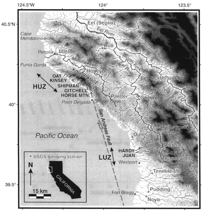
We use data from digital elevation models (DEMs), field surveys, and topo-graphic maps. DEMs have been used by numerous workers to analyze fluvial channels (e.g., Tarboton et al., 1991; Dietrich et al., 1993; Montgomery and Foufoula-Georgiou, 1993; Willgoose, 1994, Moglen and Bras, 1995; Tucker,
1996; Sklar and Dietrich, 1998; Weissel and Seidl, 1998) Comparisons
among various digital topographic analysis techniques are provided, and these methods are tested using topographic maps and field surveys for a few basins. The goal of this analysis is to critically evaluate the applicability of DEMs to study of bedrock channels in the context of the shear-stress incision model. DEMs are used to quantify channel longitudinal profile form, drainage area, and local slope, focusing on the bedrock-channel dominated part of the sys-tem. Field measurements and observations are used to constrain the relation-ship between bedrock-channel width and drainage area, and to characterize local channel morphology.
This paper is an attempt to evaluate and constrain the shear-stress model, using DEMs and field data, in a field site where the tectonic history is known. Specifically, we present data quantifying. (1) the concavity and steepness of trunk streams in study-area drainages and their dependence on uplift rate; (2) variations in the coefficient of erosion in concert with differ-ences in uplift rate; (3) the degree of nonlinearity in the relation between channel slope and incision rate; and (4) the time scale of channel response to a change in tectonic conditions.
These analyses yield a picture of landscape evolution in a bedrock-chan-nel-dominated, young mountain range. We begin by developing the theo-retical basis of the shear-stress model, with reference to the possibilities for constraining model parameters with field and DEM data. Second, the tec-tonic history, lithology, climate, and channel morphology of the Mendocino triple junction study area are described. Third, the applicability of the the-ory to the field area is carefully evaluated. Next, the methods and results of the longitudinal-profile analysis are reviewed and presented. Finally, the im-plications of the results are discussed in terms of channel-response processes and time scale.
THEORETICAL FRAMEWORK
Many workers have modeled detachment-limited bedrock-channel inci-sion using a form of the shear-stress (or similar unit stream-power) model, in which incision rate is given by a power function of drainage area and channel slope (e.g., Howard and Kerby, 1983; Seidl and Dietrich, 1992; Anderson, 1994; Howard, 1994; Moglen and Bras, 1995; Tucker, 1996; Stock and Montgomery, 1999; Whipple and Tucker, 1999). Here we
pro-vide a brief synopsis of the derivation of this law. The shear-stress model is used to describe the evolution of bedrock-channel longitudinal profiles. The objective of this section is to establish how measurements of topog-raphy and channel form in real landscapes can be used to constrain model parameters.
Shear-Stress Incision Model
The shear-stress incision model is predicated on the hypothesis that bedrock-channel-erosion rate (E), in volume per unit channel area per time,
is a power-law function of basal shear stress (T,):
E = k,,ha,
where k b is a dimensional coefficient dependent on dominant erosion
process, rock resistance, and possibly sediment load, and a is a positive, process-dependent constant. Theoretical predictions for the value of a vary from 1 for a linear-erosion process in easily eroded material (Howard and Kerby, 1983) to -5/2 for impact abrasion (Foley, 1980; Hancock et al.,
1998; Whipple et al., 2000). Combining the assumptions of conservation of
mass (water), and steady, uniform flow, the following expression for basal shear stress (Tb) is obtained:
2/3 ),
~ /3 R ,(2)
Tb =PCf~1
(2where p is density of water, C is a dimensionless friction factor, g is gravi-tational acceleration, S is local channel slope (dz/dx), Q is a characteristic stream discharge (Wolman and Miller, 1960), and W is a characteristic channel width. Next, a relationship for basin hydrology is assumed:
Q = kqA', (3)
where A is upstream drainage area, kq is a dimensional coefficient, and c is a positive constant, the value of which is approximately unity or slightly less (Dunne and Leopold, 1978; Pazzaglia et al., 1998), particularly for small, steep drainages, such as those studied here. Then, a relationship for down-stream increase in channel width with discharge is assumed, and combined with equation 3:
W= kQb = kkqbAb-, (4)
where k, is a dimensional coefficient and b is a positive constant, empirically observed to be -0.5 in alluvial rivers (Leopold and Miller, 1956). The products kkqb and bc may be found from drainage-area data and field measurements of channel width. Finally, equations 1-4 are combined to obtain the well-known shear-stress incision law,
E = KA"'S',
with the relations
K = kbk-2ok q/2a1 -b)3pag2a/i.
in = (2ac/3)(1 - b);
n = 2a/3;
m/n = c(l - b).
SNYDER ET AL.
Equations 5-9 highlight the key unconstrained parameters in the shear-stress model. Equation 9 indicates that the ratio n/n is expected to be constant for a broad set of shear-stress-driven fluvial incision processes (Whipple and Tucker, 1999), an important, testable model prediction. For the typical, em-pirically deternined values of b and c (equations 3 and 4), the value of m/n is
-0.5. However, the exponent b is only known well for alluvial channels, and
further means of constraining this ratio by measuring channel width as a func-tion of drainage area (equafunc-tion 4) are discussed in the following. This relafunc-tion reduces the modeling problem to two key unknowns: K and n. The slope ex-ponent (n) depends on the mechanics of erosion processes (a), as discussed here. Whipple and Tucker (1999) show that the value of n exerts strong con-trol on equilibrium channel slope, equilibrium topographic relief, transient profile form, and response time scale. We now briefly investigate the factors that control the value of K.
Erosion Coefficient
The erosion coefficient (K) is not well calibrated, but one study (Stock and Montgomery, 1999) has presented evidence that K varies over orders of magnitude among different study areas. K is a dimensional coefficient with units of meters' -2" yr-1. A wide variety of factors probably influ-ence K, including rock strength, channel bed material, channel width, runoff, and debris-flow frequency. Although the frequency of debris flows in a fluvially dominated channel may influence K, the shear-stress incision model is likely to be inadequate in debris-flow-dominated chan-nels (Howard, 1998; Stock and Dietrich, 1998). In addition, K, or specif-ically kb (equation 1), may be a function of sediment load, with large sed-iment concentrations protecting the bed, as argued by Sklar and Dietrich
(1998). We revisit this issue later in this paper. Within an area of
rela-tively uniform lithology, K (or an analogous erodibility parameter) has often been modeled as constant in both space and time (e.g., Seidl and Dietrich, 1992; Anderson, 1994; Kooi and Beaumont, 1996). Holding K constant in a model of landscape response to tectonic forcing includes the implicit assumption that channel gradient is the only variable that is free to adjust to changes in rock-uplift rate. However, many of the factors that control K are likely to adjust during the evolution of a mountain range. For example, higher uplift rates are likely to lead to higher topography, which leads to increased orographic precipitation, presumably increasing
kq and therefore K (equation 6). In addition, channels may narrow in re-sponse to an increase in the rate of relative base-level fall (decreasing k, and increasing K), or may become more alluviated in response to changes in sediment flux (perhaps decreasing k. and K; equation 6). We present evidence here that the coefficient of erosion (K) may indeed vary in response to tectonic forcing. We also place some preliminary con-straints on the relative importance of adjustments in channel width, bed configurations, and orographic precipitation.
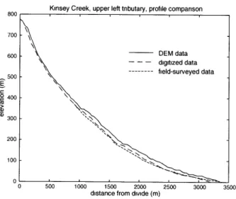
Steady-State Longitudinal Profiles
The shear-stress incision model can be combined with a statement of con-servation of mass to analyze the rate of change of river-bed elevation (dz/dt), given by a competition between uplift and erosion (e.g., Howard, 1994):
dz/dt= U - E= U - KA"S", (10)
where U is the rock uplift rate relative to base level. In the case of a steady-state landscape (dz/dt = 0), equation 10 can be solved for
equilib-rium slope (S,):
S, = (U/K) I"/A-""/',(
where, for cases of uniform U and K, m/n dictates the concavity of the equi-librium profile, and likewise the coefficient (U/K)" dictates equiequi-librium profile steepness. The power-function relation implied by equation 11 has been observed empirically in many different geologic settings, with stream gradient described by
S = kA-. (12)
The exponent, 0 (the concavity index), and coefficient, k, (the steepness in-dex), can be measured directly by regression of slope and area data. The con-cavity index (0) is generally found to be between 0.3 and 0.6 (Hack, 1957; Flint, 1974; Willgoose et al., 1990; Tarboton et al., 1991; Moglen and Bras,
1995; Slingerland et al., 1998), but values to 1.1 have been measured in some
channels (Sklar and Dietrich, 1998). The coefficient k, is similar in principle to the stream-gradient index developed by Hack (1973), but more general. In any analysis of stream longitudinal profiles, the relationships implied by equa-tions 11 and 12:
0 = m/n, (13)
(14)
k = (U/K)1",
hold true if and only if (1) the river profile is in steady state with respect to current climatic and uplift conditions; and (2) both uplift rate (U) and coef-ficient of erosion (K) are uniform through the channel reach. Where these conditions are met, the parameters (U/K)"I" and m/n can be estimated di-rectly through regressions of channel-gradient and drainage-area data. In such cases, the degree of correlation between channel steepness and rock-uplift rate can be used to place important constraints on shear-stress model parameters. If K is constant throughout the study area, a unique value of n may be determined directly. In addition, the model prediction that the m/n ratio is a constant, largely dictated by the relationship between channel width and drainage area (equation 4), can be tested directly. Whipple and Tucker (1999) derived an expression for channel response time to changes in rock-uplift rate. Predicted response times can be tested where informa-tion on the rock-uplift history is available, such as in the Mendocino triple junction region. In the discussion section of this paper, we modify the chan-nel response-time equation give by Whipple and Tucker to account for pos-sible changes in K n concert with increased uplift rate and compare pre-dicted response times to uplift history (Merritts and Bull, 1989).
FIELD AREA
The King Range is an area of rugged relief at the northern terminus of the San Andreas fault in northern California (Fig. 1). The study area consists of a subparallel series of 21 small coastal drainage basins from Cape Mendo-cino in the north, through the King Range to Fort Bragg in the south (Fig. 2; Table 1), previously studied by Merritts and Vincent (1989). Late Pleistocene and Holocene rock-uplift rates vary nearly an order of magnitude along this 120 km transect, from -3 mm yr-1 near the Bear River, to 4 mm yr-' in the King Range, to -0.5 mm yr-' at Fort Bragg (Fig. 3) (McLaughlin et al.,
1983; Merritts and Bull, 1989; Merritts, 1996). These uplift rates are
ob-tained from radiocarbon dating of fossil shells sampled either from in-place growth positions on emergent marine platforms or from within intertidal marine sediments overlying marine platforms (Merritts and Bull, 1989; Merritts, 1996). Marine platforms and cover-bed sediments are numerous throughout the study area, forming flights of uplifted late Pleistocene and Holocene marine terraces that are correlated with a eustatic sea-level curve
Geological Society of America Bulletin, August 2000
LANDSCAPE RESPONSE TO TECTONIC FORCING 124*30'W 40'30'N . 0-Mendocino fracture zone 40*30'N 4000' 39'30' 40*00'i- 39*30'i-PACIFIC OCEAN N t 10kr
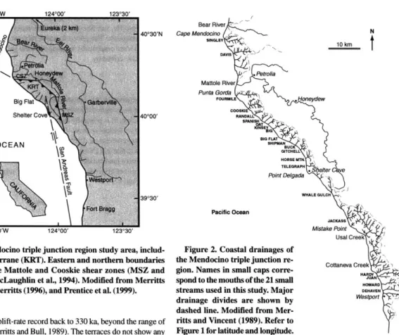
Figure 1. The Mendocino triple junction region study area, includ-ing the Kinclud-ing Range terrane (KRT). Eastern and northern boundaries of the terrane are the Mattole and Cooskie shear zones (MSZ and
CSZ), respectively (McLaughlin et al., 1994). Modified from Merritts
and Vincent (1989), Merritts (1996), and Prentice et al. (1999).
in order to extend the uplift-rate record back to 330 ka, beyond the range of radiocarbon dating (Merritts and Bull, 1989). The terraces do not show any signs of significant coast-perpendicular tilting, indicating that the uplift rates are approximately uniform within each study-area basin. Much of our analysis hinges upon these uplift-rate data, which are an important potential source of uncertainty (Merritts and Bull, 1989; Merritts, 1996). The ex-tremely high uplift rate of the King Range terrane, between the Cooskie and Mattole shear zones, is related to plate boundary interactions around the northward-propagating Mendocino triple junction (McLaughlin et al.,
1994; Merritts, 1996; Prentice et al., 1999).
The uplift-rate data and local structural geology provide a rough means of dividing the study area into four distinct zones, from north to south, the northern transition zone (Singley Creek to Cooskie Creek), the King Range high-uplift zone (Randall Creek to Gitchell Creek), the intermediate-uplift zone (Horse Mountain Creek to Whale Gulch), and the low-uplift zone (Jackass Creek to Dehaven Creek; Fig. 3). The northern and high-uplift zones underwent an acceleration in uplift rates after 96 ka from low-uplift-zone conditions (<1 mm yr') to 3-4 mm yr-1 (Merritts and Bull, 1989). Up-lift rates in the southern part of the study area have been constant for at least the past 330 k.y. (Merritts and Bull, 1989). The transition in tectonic setting from low- to high-uplift rates provides the opportunity to isolate the effects of this change by comparison of topographic data between two otherwise generally similar regions.
Bedrock lithology in the study area consists of Tertiary and Cretaceous marine sandstones and mudstones of the Franciscan assemblage (Beutner et al., 1980; McLaughlin et al., 1994). In general, the rocks are jointed on the submeter scale and easily eroded, although local variations in resistance provide some areas of small-scale lithologic control on channel characistics. In addition, the large shear zones that surround the King Range ter-rane produce differences in the level of deformation and jointing of the
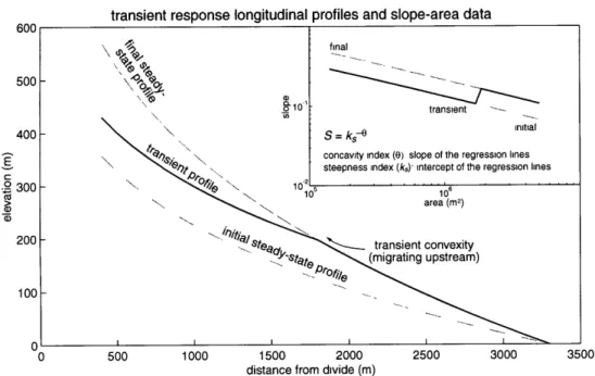
Bear River Cape Mendocino N N 10 km T DAVIS PRetrolia Mattole River Punta Gorda FOURNlLE , oeydew COOSIE RANDA SPANIS IGNSE 1 BlG FLAT , SHIPMAN GITCHELL HORSE MTN. TELEGRAPH Point Delgada WHALE GULCH Pacific Ocean JACKASS Mistake Point Usal Creek
Figure 2. Coastal drainages of
the Mendocino triple junction re- Cottaneva Creek
gion. Names in small caps corre- HARDY
spond to the mouths of the 21 small HOWARD
streams used in this study. Major DEHAVEN
drainage divides are shown by westport -dashed line. Modified from
Mer-ritts and Vincent (1989). Refer to Figure 1 for latitude and longitude.
rocks (Figs. 1 and 3; Beutner et al., 1980; McLaughlin et al., 1994). Al-though heterogeneous at the small scale, the rocks of the study area show no clear large-scale variations in lithologic resistance between catchments
(S. Ellen, unpublished data; Merritts and Vincent, 1989) although this
pos-sibility cannot entirely be ruled out.
The 21 study-area drainage basins are variable-bed-gradient bedrock streams (morphologic terminology of Wohl, 1998). The basins range from
3.1 to 20.8 km2 in area. The streams are steep and narrow. Generally, the lo-cal stream-bed morphology varies from cobble to sand plane bed near the mouths of the larger drainages to a locally variable mix of step-pool, boul-der-cascade, bedrock, and colluvial conditions in the higher parts of the basins (classification scheme of Montgomery and Buffington, 1997). Strath and fill terraces are common in many of the drainages.
In the higher, steeper channel reaches (bed slope > 1 O-2*) away from
channel mouths, the bed composition of the streams is a mix of exposed bedrock and scattered alluvial and colluvial deposits (Fig. 4A). In heavily jointed areas, plucking along joint planes appears to be the dominant ero-sion process, evidenced by numerous unweathered and only slightly abraded exposed joint surfaces. Streambed exposures of massive bedrock (joint spacing > 0.3 m) generally are polished, and probably sculpted by bedload abrasion (Fig. 4B). Discontinuous coarse-grained alluvial deposits are common throughout the basins. Occasional debris-flow deposits are found locally, particularly higher in the basins. Debris flows probably con-tribute to channel incision, but the significance of this contribution is un-known at present. Landslide deposits are common at sites of recent mass-wasting activity on steep side slopes throughout the study drainages. These colluvial deposits appear to be reworked rapidly and retransported by