HAL Id: insu-00148275
https://hal-insu.archives-ouvertes.fr/insu-00148275
Submitted on 22 May 2007HAL is a multi-disciplinary open access
archive for the deposit and dissemination of sci-entific research documents, whether they are pub-lished or not. The documents may come from teaching and research institutions in France or abroad, or from public or private research centers.
L’archive ouverte pluridisciplinaire HAL, est destinée au dépôt et à la diffusion de documents scientifiques de niveau recherche, publiés ou non, émanant des établissements d’enseignement et de recherche français ou étrangers, des laboratoires publics ou privés.
Millet cultivation history in the French Alps as
evidenced by a sedimentary molecule
Jérémy Jacob, Jean-Robert Disnar, Fabien Arnaud, Emmanuel Chapron,
Maxime Debret, Elisabeth Lallier-Vergès, Marc Desmet, Marie Revel
To cite this version:
Jérémy Jacob, Jean-Robert Disnar, Fabien Arnaud, Emmanuel Chapron, Maxime Debret, et al.. Millet cultivation history in the French Alps as evidenced by a sedimentary molecule. Journal of Archaeological Science, Elsevier, 2008, 3, pp.814-820. �10.1016/j.jas.2007.06.006�. �insu-00148275�
Millet cultivation history in the French Alps as evidenced by a sedimentary molecule
Jérémy Jacob11, Jean-Robert Disnar1, Fabien Arnaud2, Emmanuel Chapron1, Maxime Debret2, Elisabeth Lallier-Vergès1, Marc Desmet2 and Marie Revel-Rolland3.
1. ISTO, UMR 6113 du CNRS/Université d’Orléans, Bâtiment Géosciences, 45067 Orléans, France.
2. EDYTEM, UMR 5204 du CNRS/Université de Savoie, Campus Savoie Technolac, F-73376, le Bourget du Lac, France.
3. Geosciences Azur, UMR 6526 du CNRS, La Darse, B.P. 48, 06235 Villefranche sur mer, France.
Abstract
We report on the detection, in a sediment core drilled in Lake Le Bourget (French
Alps), of a fossil molecule (miliacin) that was synthesized by broomcorn millet cultivated in the watershed, and then exported to the sediment. The variation in abundance of this molecule allows us reconstructing the history of millet cultivation around Lake Le Bourget. Our results support the introduction of millet around -1700 BC in the region. After an intensive cultivation during the Late Bronze Age, the failure of millet cropping during the Hallstatt period coincides with a phase of climatic deterioration. Millet cultivation recovers during the Roman and Mediaeval periods before falling most probably due to the introduction of more productive cereals. These pioneering results constitute the first continuous record of an agrarian activity for the last 6000 yrs and emphasize the close relationships between local hydrology, land use and agro-pastoral activities around Lake Le Bourget.
Keywords: Land use, agriculture, millet, Holocene, Bronze Age, molecular biomarker, lake
sediments.
* Corresponding author e-mail address : jeremy.jacob@univ-orleans.fr (J. Jacob)
1. Introduction
Past relationships between human land-use and the earth/climate system are of direct relevance for predicting the response of continental ecosystems to a possible Global Change (Ruddiman, 2003; Dearing, 2006; Hurtt et al., 2006). High resolution sedimentary archives combined with more punctual archaeological investigations have proven useful in linking past
human activities with environmental and climatic changes (Magny et al., 2004). Nevertheless, the absence of continuous records of agrarian practices due to the lack of pertinent tracers in sedimentary archives forbids the discrimination between human land-use and climatic impacts on continental ecosystems within a common time frame.
Lake Le Bourget (Figure 1) affords an exceptional context for studying such human/climate interactions. Previous studies showed that the terrigenous fraction deposited in this lake during Rhône River floods record the hydrological variability that affected the Alps during the Holocene(Chapron et al., 2002; 2005; Arnaud et al., 2005; Revel-Rolland et al., 2005). This lake also beneficiates from a rich archaeological context that consists mostly of Neolithic and Late Bronze Age settlements, but also of archaeological sites dated from the Iron Age, the Roman and the Middle Age periods (Marguet, 2002; Figure 1).
Fossil molecules produced by once-living organisms can be preserved in sedimentary archives and have proven useful in reconstructing past environments and biological communities(Meyers, 2003). Some of these molecules are produced by a narrow range of organisms. When found in sediments they allow certifying the former presence of their
biological sources in the catchment. For example, the detection in tropical lacustrine sediments of pentacyclic triterpene methyl ethers (PTMEs) specific of gramineae offers the possibility to decipher the dynamics of various grasses through time (Jacob et al., 2005). We here reconstruct the history of millet cultivation in the catchment of Lake Le Bourget from the
variation in concentration of a specific molecule (miliacin) detected in the sediments of this lake.
2. Materials and methods
Lake Le Bourget is a foreland lake located in front of the French NW Alps (45°N 45’ ;
5°E 52’, 231,5 m a.s.l., 18 km long, 2-3 km wide, 146 m deep). The catchment area is characterized by a local watershed of 600 km2 related to the Leysse and Sierroz rivers that expands up to 4000 km2 during sporadic major flooding events of the Rhône River through Lake Le Bourget outlet, the Savière canal (Figure 1).
Cores LDB04-I and LDB04-II (N 45°47,140; E 5°50,440) were retrieved in 2004, at 106 m depth, with an UWITEC coring device operated from a barge. This coring site was selected on the basis of the seismic data(Chapron et al., 2005) at the entry of the Savière canal (Figure 1). The sediments deposited at this site are assumed to better record the flooding activity of the Rhône River into the lake than core LDB01 previously taken in a more distal depocenter (Chapron et al., 2005; Arnaud et al., 2005). A 14 m continuous composite series (LDB04) was established from two series of overlapped 3m-long cores according to sedimentological properties.
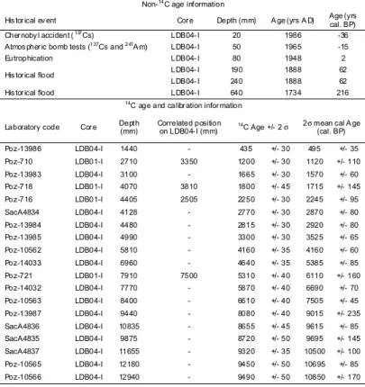
The age model was first established by using ten AMS 14C radiocarbon dates performed at the Radiocarbon Laboratory in Poznan and at the Laboratoire de Mesure du
Carbone 14 in Gif-sur-Yvette (Table 1). Four additional 14C AMS dates from core LDB01
(Chapron et al., 2002; Arnaud et al., 2005) were integrated in the age model. Their stratigraphic position in core LDB01 was reported on core LDB04 by comparing the magnetic susceptibility and colour measurements performed at a 5 mm sampling step on both cores. Over the historical period a detailed dating was obtained using radiometric markers, the onset of lake eutrophication in 1948 and a series of thick flood deposits corresponding to historical
catastrophic floods that occurred in years 1732-1734(Table 2; Chapron et al., 2002). All calibrated ages were computed according to the 5.0.2 version of Intcal, using the calibration curve of Reimer et al., 2004). Samples between 583 and 698 cm depth correspond to a slump. The resulting age-depth relationship is illustrated in Figure 2.
120 samples of 1 cm thickness covering the 2000 AD / -4000 BC time interval were
selected for lipid analyses on the 7 first meters of core LDB04. The sampling interval is 10 cm over the core except for the 2-5 m section that beneficiated from a higher resolution (3-5 cm). 2g of dried sediment were extracted three times with a mixture of dichloromethane:methanol (1:1 v/v). After centrifugation, the supernatants were combined and dried under nitrogen before separation into acidic and neutral compounds according to Jacob et al. (2005). The neutral fraction was analysed by Gas Chromatography-Mass Spectrometry following the procedure modified from Jacob et al. (2005). Due to possible coelutions during GC separation, miliacin abundances were estimated by measuring the area of the miliacin peak on the m/z 189+204+218 ion specific chromatogram. 5α-cholestane was used as an internal standard and miliacin (provided by Pr. R. Smith, Loughborough University, UK) was used as an external standard.
Bulk sedimentary titanium (Ti) was measured over the core at 1 cm spacing with a profiling XRF core scanner at the University of Bremen. Ti is given as counts per seconds (Figure 3c).
3. Results and interpretation
Miliacin (olean-18-en-3β-ol methyl ether; Figure 3a) is the sole PTME detected in the lipid extract of sediment samples selected on core LDB04. PTMEs are constituents of leaf waxes and are considered rather resistant to diagenesis, due to the supposed antifungal or
PTMEs were produced in significant amount in the catchment, they should be detected in our GC traces. Since this is not the case, miliacin was the only PTME produced in significant amounts on the lake surroundings. Despite their resistance, pentacyclic triterpenes are known to suffer minor structural rearrangements during diagenesis (ten Haven et al., 1992; Rullkötter
et al., 1994). However, oleanane-type compounds owning a double bond at the ∆18 position (as miliacin) are the less thermodynamically stable isomers and are most likely to suffer
rearrangements, such as double bond migration, into the more stable ∆13,18 or ∆12 isomers, whereas the reverse is unlikely. Therefore, miliacin cannot result from the diagenesis of other PTMEs with an oleanane structure.
Very few plants are known to produce miliacin as the sole PTME(Ohmoto et al., 1970; Jacob et al., 2005). They comprise Microstegium vimineum, Panicum miliaceum, P.
dichotomiflorum, Syntherisma sanguinalis and Glyceria acutifolia. Archeaobotanical studies
performed on a contemporaneous lake-shore settlement (Grésine, Figure 1) afforded a rather realistic panorama of the surrounding vegetation (Bouby and Billaud, 2001). The confrontation of the known exclusive miliacin producers with this regional inventory supports
Panicum miliaceum (broomcorn millet) as the sole possible source of miliacin in the
catchment. This introduced cereal was cultivated for staple food, as demonstrated by the numerous millet remains found at the Grésine archaeological site (Bouby and Billaud, 2001).
Although miliacin may be transported by runoff that affects soils formerly cultivated for millet, leaf waxes are predominantly ablated and wind transported on short distances with no time lag (e.g. Hughen et al., 2004). Therefore, miliacin detected in the sediments of Lake Le Bourget attests to the cultivation of millet in the vicinity of Lake Le Bourget, at the time of sediment deposition.
The first occurrence of miliacin at ca. 1700 BC (Figure 3b) is consistent with the supposed introduction of millet in the region (Marinval, 1995) during the Bronze Age. It extends down to 1700 BC the previous estimation of intensive human impact on soils in the region (Chapron et al., 2005), although agrarian activities might have been constrained to the landscape surrounding the villages at that time (Bouby and Billaud, 2001). The drastic
decrease in miliacin concentrations at ca. 800 BC coincides with relatively high Ti values (Figure 3c) that attest to an increase in Rhône river floods into Lake Le Bourget. This corresponds to the regionally recorded climatic deterioration supposedly responsible for the abandonment of lake-dwelling habitats (Magny, 2004). The 500 BC/700 AD time interval shows higher concentrations of miliacin, in agreement with evidences of intensive agro-pastoral activity in the region (Chapron et al., 2005). The sudden decrease of miliacin concentrations at 700 AD could illustrate the replacement of millet by other cereals or, alternatively, the failure of farming due to higher hydrological activity, as attested again by high Ti scores (Figure 3c). Then, low concentrations of miliacin reflect an input from the erosion of soils formerly cultivated for millet.
4. Conclusion
The detection of a sedimentary lipid specific of a cultivated plant provides the first continuous record of an agrarian activity in the catchment of Lake Le Bourget. By comparing this record with an index of hydrological variability in the region we show that periods of
enhanced rainfall over the area affected the intensity of millet cropping. Because other plants of economic interest such as Oryza sativa (rice) or Sorghum bicolor (sorghum) synthesize molecules related to miliacin (Jacob et al., 2005), the detection of such compounds in time-constrained continental archives will provide outstanding insights into the dynamics of agriculture history.
Acknowledgments
This work is part of the APHRODYTE project, supported by the French CNRS (Programme ECLISPE 2005-2006). We thank J. Dearing for improving the manuscript and anonymous reviewers for their constructive comments.
References
Arnaud, F., Revel, M., Chapron, E., Desmet, M., Tribovillard, N., 2005. 7200 years of Rhône River flooding activity in Lake Le Bourget: a high-resolution sediment record of the NW Alps hydrology. Holocene 15, 420-428.
Bouby, L., Billaud, Y., 2001. Economie agraire à la fin de l’âge du Bronze sur les bords du lac du Bourget (Savoie, France). Cr. Acad. Sci. II A 333, 749–756.
Chapron, E., Arnaud, F., Noël, H., Revel, M., Desmet, M., Perdereau, L., 2005. Rhône River flood deposits in Lake Le Bourget: a proxy for Holocene environmental changes in the NW Alps, France. Boreas 35, 404-415. Chapron, E., Desmet, M., De Putter, T., Loutre, M.F., Beck, C., Deconninck, J.F., 2002. Climatic variability in
the northwestern Alps, France, as evidenced by 600 years of terrigenous sedimentation in Lake Le Bourget. Holocene 12, 177–185.
Dearing, J., 2006. Climate-human-environment interactions: resolving our past. Clim. Past 2, 187–203.
Ten Haven, H.L., Peakman, T.M., Rullkötter, J., 1992. Early d iagenetic transformation of higher-plant triterpenoids in deep-sea sediments from Baffin Bay. Geochim. Cosmochim. Acta 56, 2001–2024.
Hughen, K.A., Eglinton, T.I., Xu, L., Makou, M., 2004. Abrupt tropical vegetation response to rapid climate changes. Science 304, 1955-1959.
Hurtt, G.C., Frolking, S., Fearon, M.G., Moore III, B., Shevliakova, E., Malyshev, S., Pacala, S., Houghton, R.A., 2006. The underpinnings of land-use history: three centuries of global gridded land-use transitions, wood-harvest activity, and resulting secondary lands. Glob. Change Biol. 12, 1208-1229.
Jacob, J., Disnar, J.R., Boussafir, M., Sifeddine, A., Albuquerque, A.L.S., Turcq, B., 2005. Pentacyclic triterpene methyl ethers in recent lacustrine sediments (Lagoa do Caçó, Brazil). Org. Geochem. 36, 449–461.
Magny, M., 2004. Ho locene climate variability as reflected by mid-European lake-level fluctuations and its probable impact on prehistoric settlements. Quat. Int. 113, 65–79 (2004).
Marguet, A., 2002. Savoie, lac du Bourget. Elaboration de la carte archéologique des gisements du lac du Bourget. In: Bilan Scientifique 2000 du DRASSM 26. Ministère de la Culture et de la Communication, Paris, p. 117-137.
Marinval, P., 1995. Données carpologiques françaises sur les Millets (Panicum miliaceum L. et Setaria italica L. Beauv.) de la Protohistoire au Moyen Age. In: Hörandner, E. (Ed.) Millet. Actes du Congrès d’Aizenay (1990). Peter Lang, Frankfurt, p. 31-61.
Meyers, P.A., 2003. Applications of organic geochemistry to paleolimnological reconstructions: a summary of examples from the Laurentian Great Lakes. Org. Geochem. 34, 261-289.
Ohmoto, T., Ikuse, M., Natori, S., 1970. Triterpenoids of the Gramineae. Phytochem. 6, 2137-2148.
Reimer, P.J., Baillie, M.G.L., Bard, E., Bayliss, A., Beck, J.W., Bertrand, C., Blackwell, P.G., Buck, C.E., Burr, G., Cutler, K.B., Damon, P.E., Edwards, R.L., Fairbanks, R.G., Friedrich, M., Guilderson, T.P., Hughen, K.A., Kromer, B., McCormac, F.G., Manning, S.W., Ramsey, C.B., Reimer, R.W., Remmele, S., Southon, J.R., Stuiver, M., Talamo, S., Taylor, F.W., van der Plicht, J., Weyhenmeyer, C.E., 2004. IntCal04 terrestrial radiocarbon age calibration, 0–26 cal kyr BP. Radiocarbon 46, 1029-1058.
Revel-Rolland, M., Arnaud, F., Chapron, F., Desmet, M., Givelet, N., Alibert, C., McCulloch, M., 2005. Sr and Nd isotopes as tracers of clastic sources in Lake Le Bourget sediment (NW Alps, France) during the Little Ice Age: Palaeohydrology implications. Chem. Geol. 224, 183-200.
Ruddiman, W.F., 2003. The anthropogenic greenhouse era began thousands of years ago. Climate Change 61, 261-29.
Rullkötter, J., Peakman, T.M., ten Haven, H.L., 2004. Early diagenesis of terrigenous triterpenoids and its implications for petroleum geochemistry. Org. Geochem. 21, 215–233.
Table captions
Table 1: 14C and non-14C dates used for the establishment of core LDB04 age model.
Non-14C age information
His torical ev ent Core Depth (mm) A ge (yrs A D) Age (yrs cal. BP)
Chernoby l accident (137Cs) LDB04-I 20 1986 -36
Atmos pheric bomb tests (137Cs and 241A m) LDB04-I 50 1965 -15
Eutrophication LDB04-I 80 1948 2
LDB04-I 190 1888 62
His torical flood
LDB04-I 240 1888 62
His torical flood LDB04-I 640 1734 216
14C age and calibration information
Laboratory code Core Depth (mm) Correlated position on LDB04-I (mm) 14C Age +/- 2 σ 2σ mean cal A ge
(cal. BP) Poz-13986 LDB04-I 1440 - 435 +/- 30 495 +/- 35 Poz-710 LDB01-I 2710 3350 1200 +/- 30 1120 +/- 110 Poz-13983 LDB04-I 3100 - 1665 +/- 30 1570 +/- 60 Poz-718 LDB01-I 4070 3810 1800 +/- 45 1715 +/- 145 Poz-716 LDB01-I 4405 2505 2250 +/- 30 2245 +/- 95 SacA4834 LDB04-I 4128 - 2770 +/- 30 2870 +/- 80 Poz-13984 LDB04-I 4480 - 2815 +/- 30 2920 +/- 80 Poz-13985 LDB04-I 4990 - 3300 +/- 30 3525 +/- 65 Poz-10562 LDB04-I 5810 - 4160 +/- 35 4160 +/- 60 Poz-14033 LDB04-I 6960 - 4640 +/- 35 5385 +/- 85 Poz-721 LDB01-I 7910 7500 5310 +/- 40 6110 +/- 160 Poz-14032 LDB04-I 7770 - 5870 +/- 40 6690 +/- 70 Poz-10563 LDB04-I 8400 - 6610 +/- 40 7505 +/- 45 Poz-13987 LDB04-I 9440 - 8080 +/- 40 9015 +/- 235 SacA4836 LDB04-I 10835 - 8655 +/- 45 9615 +/- 85 SacA4835 LDB04-I 9875 - 8720 +/- 50 9695 +/- 145 SacA4837 LDB04-I 11655 - 9320 +/- 35 10500 +/- 100 Poz-10565 LDB04-I 12180 - 9450 +/- 50 10695 +/- 85 Poz-10566 LDB04-I 12940 - 9490 +/- 50 10850 +/- 170
Figure captions
Figure 1: Location of Lake Le Bourget and coring sites. The grey arrow indicates the trajectory of Rhône river floods over the Chautagne swamp and the Savière canal. Numerous archaeological sites ranging from the Neolithic up to the Mediaeval Period have been studied around Lake Le Bourget (Marguet, 2002). The Grésine site, dated to the Late Bronze Age,
afforded numerous botanical remains such as seeds of Panicum miliaceum (broomcorn millet).
Figure 2: Age-depth model for core LDB04 established from 14C and non-14C dates listed in Table 1.
Figure 3: (a) Structure of miliacin (olean-18-en-3β-ol ME). Miliacin is a pentacyclic triterpene (three terpene motifs arranged into five cycles) that bears a methyl ether group (-O-CH3). Although pentacyclic are common in the plant kingdom, those with a methyl ether group are principally synthesised by grasses (Jacob et al., 2005). In the case of Lake Le Bourget, miliacin found in sediments attests to the crop growing of broomcorn millet in the catchment. (b) Evolution of miliacin relative abundance in ng/g sediment. (b) Variations of titanium (Ti, in counts per second; cps). Titanium accounts for the occurrences of Rhône River floods in Lake Le Bourget. The sediment load carried to Lake Le Bourget during Rhône River floods is enriched in Ti as compared to the sediments normally deposited in Lake Le Bourget(Revel-Rolland et al., 2005). Higher Ti values hence attest to higher activity of the Rhône River due to higher precipitation over the Rhône catchment.
Rhôn e Ri ver 5 km La ke L e B ourg et N FRANCE Lake Le Bourget R hône R iv er Arve River Lake Geneva JURA ALPS Chautagne swamp Chautagne swamp Leys se ri ver Grésine Grésine LDB01 LDB01 LDB04 LDB04 Savière canal Savière canal Neolithic Late Bronze Age Mediaeval Period Antiquity Iron Age
Figure 1
Sierro z rive r Coring site Figure 1Reworked deposit
non-continuous stratigraphy
9
8
7
6
5
4
3
2
1
0
D
ep
th
(m
)
0
1
2
3
4
5
6
7
8
9
10 11
Age (ka cal. BP)
Chernobyl 137Cs peak
Nuclear weapon tests
137Cs peak
Lake eutrophication
(AD 1948)
AD 1734
major flood (64 cm )
30
25
20
15
10
5
0
D
ep
th
(c
m
)
2000 1980 1960 1940 1920 1900 1880 1860
A ge (AD)
LDB04 14C ages
LDB01 14C ages (correlated)
AD 1734 major flood
Figure 2 Figure 2M ilia ci n (n g/ g se d) M ilia ci n (n g/ g se d) La te M id E ar ly Iron Age
Age (yrs AD/BC)
Bronze Age La T èn e H al ls ta tt b R om an P er io d Middle Age M od er n tim es Figure 3 Ti ta ni um (c ps ) Ti ta ni um (c ps ) 0 0 400 400 800 800 -4 00 0 -3 80 0 -3 60 0 -3 40 0 -3 20 0 -3 00 0 -2 80 0 -2 60 0 -2 40 0 -2 20 0 -2 00 0 -1 80 0 -1 60 0 -1 40 0 -1 20 0 -1 00 0 -8 00 -6 00 -4 00 -2 00 0 20 0 40 0 60 0 80 0 10 00 12 00 14 00 16 00 18 00 20 00 c 0 0 100 100 200 200 300 300 400 400 500 500 R ew or ke d de po si ts N o m ilia ci n de te ct ed Neolithic a O H3C miliacin Figure 3