HAL Id: hal-01522430
https://hal.archives-ouvertes.fr/hal-01522430
Submitted on 15 May 2017HAL is a multi-disciplinary open access archive for the deposit and dissemination of sci-entific research documents, whether they are pub-lished or not. The documents may come from teaching and research institutions in France or abroad, or from public or private research centers.
L’archive ouverte pluridisciplinaire HAL, est destinée au dépôt et à la diffusion de documents scientifiques de niveau recherche, publiés ou non, émanant des établissements d’enseignement et de recherche français ou étrangers, des laboratoires publics ou privés.
airborne campaign.
Laurent Rousset-Rouviere, Christophe Coudrain, Sophie Fabre, Yann Ferrec,
Laurent Poutier, Françoise Viallefont, Thomas Rivière, Xavier Ceamanos,
Trond Loke, Andrei Fridman, et al.
To cite this version:
Laurent Rousset-Rouviere, Christophe Coudrain, Sophie Fabre, Yann Ferrec, Laurent Poutier, et al.. SYSIPHE, an airborne hyperspectral imaging system from visible to thermal infrared. Results from the 2015 airborne campaign.. 10th EARSEL SIG Imaging Spectroscopy, Apr 2017, ZURICH, Switzerland. �hal-01522430�
VISIBLE TO THERMAL INFRARED. RESULTS FROM THE 2015
AIRBORNE CAMPAIGN.
Laurent Rousset-Rouviere1*, Christophe Coudrain1, Sophie Fabre1, Yann Ferrec1, Laurent Poutier1, Françoise Viallefont1, Thomas Rivière1, Xavier Ceamanos1, Trond Løke2, Andrei
Fridman2, Ivar Baarstard2, Torbjørn Skauli3, Isabelle Sisakoun4
1. ONERA – The French Aerospace Lab – BP 80100 – F-91123 Palaiseau Cedex – France – contact.sysiphe@onera.fr
2. Norsk Elektro Optikk AS, Prost Stabels vei 22, N-2019 Skedsmokorset, Norway
3. Norwegian defence research establishment (FFI) – P.O. Box 25, NO-2027 Kjeller, Norway 4. DGA – 60 Bd du Général Martial Valin 75509 Paris Cedex 15 - France
1 ABSTRACT
SYSIPHE is an airborne hyperspectral imaging system covering all atmospheric transmission bands from 0.4µm to 11.5µm. The ground sampling distance is 0.5m over a 500m swath, with higher resolution available in the visible and NIR. SYSIPHE is flown on a Do-228 aircraft operated by DLR. The system also comprises a real-time processing capability and a ground post-processing chain. The main information products are georeferenced images of spectral radiance, spectral emissivity and reflectance as well as a surface temperature map.
After a certification campaign in 2013, qualification airborne campaign for military applications was carried out during the summer of 2015, and this system is now available to external users, representing a significant enhancement of airborne sensing capabilities in Europe. After a brief description of the system and of the 2015 campaign, we present some experimental results from this airborne campaign.
Keywords: Remote sensing, infrared, multispectral, hyperspectral, airborne, SYSIPHE,
SIELETERS, ODIN, thermal infrared, spectroscopy, Fourier transform
2 INTRODUCTION
SYSIPHE is an airborne hyperspectral imaging system covering all atmospheric transmission bands from 0.4µm to 11.5µm: visible, NIR, SWIR, MWIR and LWIR. The ground sampling distance is 0.5m over a 500m swath, with higher resolution available in the visible and NIR. The imaging system, developed by Onera and Norsk Elektro Optikk, is flown on a Do-228 aircraft operated by DLR. The SYSIPHE system also comprises a real-time processing capability developed by FFI in collaboration with NEO and a ground post-processing chain, the STAD, developed by Onera. The main information products are georeferenced images of spectral radiance, spectral emissivity and reflectance as well as a surface temperature map.
SYSIPHE represents a significant enhancement of airborne sensing capabilities in Europe. The system is now available to external users, after having completed its first flight campaign successfully in 2013, and a qualification airborne campaign for Defense applications was done during the summer of 2015. In the next section, we give a brief description of the system. We then present the 2015 campaign, with experimental images and results.
3.1 System architecture
SYSIPHE is an airborne hyperspectral imaging system, built in collaboration between France and Norway, supported by French and Norwegian ministry of defense (FFI and DGA). It is unique by having a very wide spectral coverage, from 0.4µm to 11.5µm in the atmospheric transmission bands, combined with a high spatial resolution: 0.5m ground sampling distance over a 500m swath.
To achieve this unique performance, SYSIPHE is composed of three instruments, one dispersive spectrometer for the visible domain (VIS [0.4-0.8 µm]), Near InfraRed domain (NIR [0.8-1.4 µm]) and ShortWave InfraRed domain (SWIR [1.4-2.5 µm]), developed by the Norsk Elektro Optikk in Norway (NEO), and two Fourier transform spectrometers (FTS) for the MidWave InfraRed domain (MWIR [3–5.2 µm]) and the LongWave InfraRed domain (LWIR [8-11.5 µm]) , developed by the French aerospace laboratory Onera. These three instruments are integrated on the same aircraft, a DO-228 operated by DLR in Germany. By having imagers for all bands in the same aircraft, associated to inertial measurement units, SYSIPHE can produce georeferenced images of spectral radiances acquired at the same time in the same environment with more than 500 spectral bands covering the whole spectral domain.
The SYSIPHE system also integrates a ground processing chain, the STAD, developed by Onera to register the georeferenced hyperspectral images provided by each instrument and to produce outputs as spectral radiance, ground spectral reflectance, and surface temperature maps. All these products are georeferenced.
3.2 The visible-near infrared instrument (HySpex ODIN-1024)
HySpex ODIN-1024 [1] (Figure 1) is the visible and shortwave infrared part of the SYSIPHE system. It consists of two pushbroom imaging spectrographs based on transmissive gratings. These two modules share a common fore-optics and a common slit, to ensure perfect registration between the VNIR (Visible-NIR) and the SWIR images. The spectral sampling varies from 3.0nm in the VNIR to 6.1nm in the SWIR. In its current configuration in SYSIPHE, Odin has a passively damped mount, without active stabilization. An onboard spectral and radiometric calibration source enables in-flight checking of the spectral and radiometric calibration stability, which has proven to be excellent.
Table 1: Main technical specifications for HySpex Odin-1024
Parameter VNIR SWIR
Spectral range 400-1000nm 950-2500nm
Spectral resolution 3.0nm 6.1nm
Pixel FOV 0.25/0.125mrad 0.25mrad
Total across track FOV 15° 15°
Spatial resolution 1024/2048px 1024px
F-number F1.64 F2.0
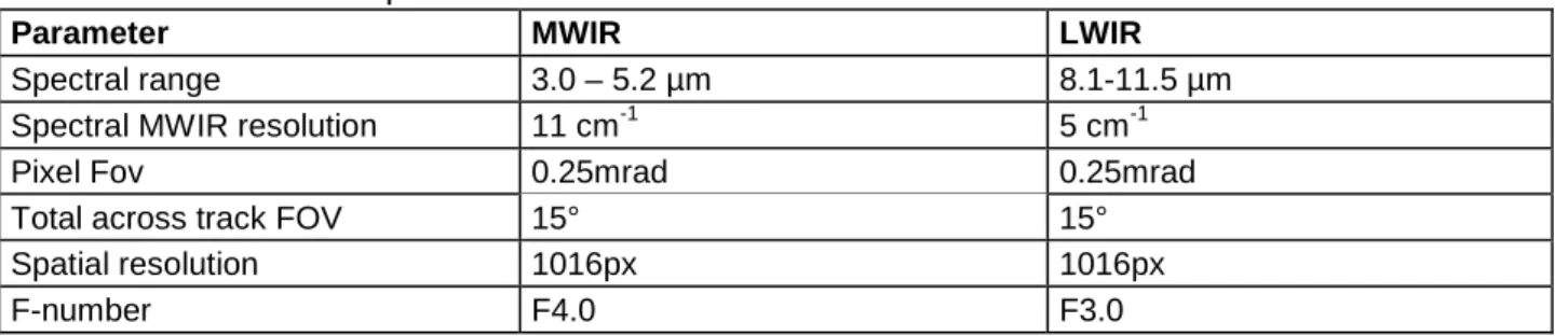
3.3 The MWIR/LWIR instrument (SIELETERS)
SIELETERS [2] is the infrared component of SYSIPHE. It is composed of two distinct Fourier transform spectrometers, one for the MWIR and one for the LWIR. The spectral resolution, taken to be 1.2/(2*MPD), where MPD is the Maximum Path Difference of the interferometer, is 11 cm-1 in the MWIR and 5 cm-1 in the LWIR. Both instruments are cryogenically cooled to achieve high performance absolute measurements, and both are imaging static Fourier transform spectrometers (ISFTS) [3,4].
Table 2:Main technical specifications for SIELETERS
Parameter MWIR LWIR
Spectral range 3.0 – 5.2 µm 8.1-11.5 µm
Spectral MWIR resolution 11 cm-1 5 cm-1
Pixel Fov 0.25mrad 0.25mrad
Total across track FOV 15° 15°
Spatial resolution 1016px 1016px
F-number F4.0 F3.0
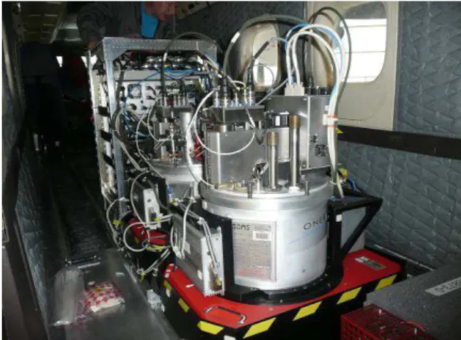
Each instrument is installed on a specific gyro-stabilized platform based on the Leica Geosystems PAV80 to control the line of sight (LOS), in the Nadir direction during recording. The control loop system controls the different phases of the flight (take-off, landing, transit flight, and recording) and the coupling between the two stabilized platforms. On one stabilized platform, an independent high precision Inertial Measurement Unit (IMU, PosPac 610 from Applanix) was installed, working in open-loop mode, to check, and to improve the quality of the LOS control for postprocessing. Figure 2 shows the two SIELETERS instruments, each on their own stabilization platform unit.
Figure 2. The SIELETERS spectral imagers
3.4 The processing and archiving system (STAD)
The last component of SYSIPHE is the processing and archiving system. It collects the products from ODIN and SIELETERS and verifies their completeness (presence or absence of files in the product and the presence or absence of specific information in the file headers like for example the definition of the projection system). The inter-instrument registration module of the STAD provides a single georeferenced hyperspectral radiance image covering the whole spectral domain. The STAD then performs atmospheric correction, in order to produce an estimation of spectral reflectance, emissivity and temperature of the scene.
Atmospheric correction is based on two modules, one to estimate the spectral reflectance in the VNIR and SWIR spectral domain, and the other one to estimate both spectral reflectance and temperature of the surface in the thermal infrared spectral domain. For the VNIR-SWIR domain, this module uses the Cochise software [5,6] supported by the ONERA/DOTA. For the MWIR-LWIR domain, a dedicated autonomous method (without need of additional atmospheric measurement) has been developed. It is based on neural network [8,9] used to estimate the atmospheric thermodynamic parameters from the hypercubes acquired by the Sieleters system. The radiative atmospheric terms are then assessed with the radiative transfer code MODTRAN [10] and the emissivity/temperature separation is done by a spectral smoothness algorithm.
All the data are collected in a database searchable by a dedicated GUI based on GeoNetwork. The SYSIPHE system normally offers two product levels for the users:
• The georeferenced spectral radiance images at the sensor level covering the whole spectral range (from visible to LWIR- band) ;
• The target spectral reflectance/emissivity after atmospheric correction and the related temperature image.
The STAD products include hyperspectral image, quality matrix image and optional temperature image. Each image is associated with a header file in the ENVI (Environment for Visualizing Images) format and an ASCII header file containing information supplied by each module (version, data input, intrinsic parameter values, … ). The image format is BSQ (Band SeQuential).
Figure 3 illustrates the SYSIPHE post-processing scheme and the different product levels which can be delivered to the users depending of their applications.
Figure 3 : SYSIPHE post-processing scheme and products levels
4 2015 SYSIPHE QUALIFICATION CAMPAIGN
4.1 The August 2015 qualification airborne campaign
The data acquired during the 2013 airborne campaign could not address all the verification needed to validate the Sysiphe system, especially the verification of the spectro-radiometric calibration of the instruments and the atmospheric correction software included in the STAD. A new airborne campaign was carried out in August 2015 where measurements in clear sky conditions were done.
This campaign was located in the South of France, over the military base of Canjuers. A ground truth target array was deployed consisting of many different surfaces (Figure 4) such as grey linoleum, black and white targets, polystyrene, sand, painted concrete, etc.
(a) (b) (c)
(d) (e) (f)
Figure 4: Targets and reference ground surfaces for ground truth measurements. (a) black and white panels, (b) linoleum panels, (c) polystyrene panel, (d) painted concrete, (e) sand, (f) clay.
In parallel, military scenarios were deployed in the Canjuers base to acquire full bandwidth hyperspectral images with SYSIPHE. Figure 5 illustrates some of the types of targets that were present.
Figure 5: Examples of targets used during the campaign.
The aircraft was located on the French Navy Air base of Hyères.
This qualification campaign was highly successful thanks to participation of all the different teams involved in the campaign, around 50 persons in total. The system flew 7 times without any failure, including a night flight. Different meteorological conditions were encountered, including clear sky, partially cloudy and windy, opening new studies on the robustness of hyperspectral products as a function of the weather conditions.
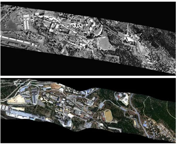
4.2 ODIN and SIELETERS image registration performance
The two spectral images are georeferenced in the WGS84 - UTM 32 North coordinate system, with a spatial resolution of 0.5m x 0.5m for ODIN and SIELETERS. The STAD processing shows that the intra-instrument registration resulting from the ODIN and SIELETERS processing is good (less than 1 pixel). Figure 6 shows a sample flight line by Sieleters (georeferenced image) and ODIN (RGB georeferenced composition). Observe that the ODIN line traces a slightly curved path, since there is no active stabilization of ODIN in the present configuration of SYSIPHE. The scene geometry remains correct, after the georeferencing step, and the coregistration with SIELETERS is good.
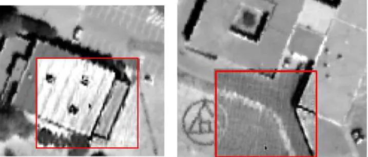
mapping agency. The BD ORTHO® includes color orthophoto with spatial resolution of 0.5m covering France in the Lambert 93 projection system. The georeferencing precision of ODIN is about 1 to 2 pixels. These residual errors are linked to the use of a 30m DTM resolution and the use of Google Earth to do the boresight calibration for ODIN georeferencing and orthorectification. There may also be contributions from the intrinsic error of the GDAL and QGIS tools used to manage the projection of the 2 images on the same window. The georeferencing precision of SIELETERS is also about 1 to 2 pixels. But during the STAD registration tests, SIELETERS image did not reach this georeferencing precision because the static parameters of Sieleters line of sight were not fully optimized. The geolocalisation accuracy was around 4-5 pixels, therefore we can observe, before the STAD processing, a misregistration between ODIN and SIELETERS as shown in Figure 7. This is now corrected.
An image-based inter-instrument registration is then done taking ODIN product as reference. The registration process is applied to the 1.55µm spectral image for ODIN and the 4.7µm spectral image for SIELETERS. This method includes two stages: estimation of the deformation model between the two products based on a geometric correlation and then application of the deformation model on the SIELETERS product with a resampling tool. The result is illustrated in Figure 8. The global evaluation of the inter-instrument registration performance on several flight lines indicates a precision better than 0.3 pixel, showing the very good quality of the inter-instrument STAD registration.
Figure 7: Misregistration detail between the ODIN band at 1.55 µm and the SIELETERS band at 4.7 µm. The Sieleters image is superimposed (red square) on the ODIN image.
Figure 8: STAD registration result illustration by superimposition of the 4.7 µm spectral band over the 1.55 µm spectral band of ODIN.
4.3 Reflectance first results from ODIN data
The ODIN spectral image acquired over the ground truth workshop set up near the stadium of Canjuers village was used to verify the calibration of the inflight instrument and the performance of the atmospheric correction.
The atmospheric characterization included a RPG-Hatpro millimeter wave radiometer to assess the atmospheric vertical profile (pressure, temperature and humidity) and a Cimel sun photometer to retrieve the aerosol type and visibility.
COMANCHE [5] radiative transfer simulations and compared to its laboratory calibration.
To overcome a radiometric discrepancy between the measurement and simulation, a spectral gain was systematically applied to ODIN acquisitions (see Figure 9). This effect is caused by a calibration discrepancy at the shortwave end of the ODIN spectrum. This discrepancy has been resolved and will eliminate the need for this temporary recalibration step in the future.
Figure 9: Spectral gain to be applied on ODIN data
The spectral characterization of ODIN data was done using the same dataset. It revealed a negligible spectral shift of 0.2 nm all over the ODIN bandwidth and field of view, and it confirmed a VNIR and SWIR resolution respectively equal to 4.2 nm and 9.2 nm.
The atmospheric correction was then done using COCHISE code [5], [6] starting by the estimation of the columnar water vapor map followed by the reflectance estimation process.
22 different ground materials measured with an ASD spectrometer were compared to the retrieved ODIN reflectance hypercube. The Empiric Line Method (ELM) based on the two linoleum tarps dedicated to the calibration assessment was also processed. The global error on the reflectance product is presented on Figure 10.
Figure 10 : Global error on the reflectance over the whole set of targets
The global error compared to the ELM results shows good accordance in the visible, and over most part of the SWIR band. Differences can be noticed in the 1.5 to 1.8 µm band. This difference is not explained today and is under investigation. The other difference near 2.5µm is due to the very close value of the reflectance of the 2 linoleum patterns.
However, we can say that the performance of ODIN instrument coupled to the Cochise atmospheric process is good, after applying a gain factor to the ODIN radiance, as shown in Figure 11.
Figure 11 : ground truth spectra (red curves) compared to ELM results (orange), Cochise correction directly with ODIN spectra (dark), with ODIN data recalibrated (blue) and ODIN data
recalibrated and spectrally shifted (green) for 4 kinds of materials : grey linoleum (up-left), polystyrene (up right) concrete (down left) and stadium (down right). Be aware with the scale of the
reflectance adapted to the dynamic of the curves
4.4 Spectral radiance validation of Sieleters data
The SIELETERS spectral image acquired over the ground truth workshop installed near the Canjuers village has been processed and compared to spectral radiance measured on ground. The ground measurements were done synchronously with the Sieleters acquisition. The ground radiances were then propagated to the entrance window of Sieleters instrument through the atmosphere and convolved with the Sieleters instrument shape response.
Figure 12 : Sieleters image extraction at wavelengths of 4.8µm (top) and 10.75µm (bottom) over the ground truth site at Canjuers
A spectral NEDR was estimated for the MWIR and the LWIR instrument using the response of 10x10 pixels on one of the linoleum targets. Figure 13 shows the NEDR, indicating a low level of radiometric noise. Nevertheless, the comparison with ground truth spectra highlights oscillations in the mean of the inflight spectra, and an important dispersion, as we can see on Figure 14 and Figure 15 for two kinds of material. Globally, the shapes of the spectra are well respected as the radiance level, but the oscillations have to be reduced to improve the spectral quality. The causes of those oscillations are not completely understood. The main hypothesis addresses the non-uniformity correction of infrared image which is not good enough and also due to twinkling pixels. An important thing to know is that the Sieleters instruments do not have on-board calibration. A combination of laboratory calibration data and the in-flight images are used to re-estimate the gain and background correction to be applied. The main difficulty is to estimate gain and background with the presence of the fringes on the images (because it is a static Fourier transform instrument), and the spatial temperature variation of the scene. An improved non uniformity correction is in progress and new tests of the spectral quality will be done soon.
Figure 13: spectral noise equivalent radiance for MWIR and LWIR instrument estimated on a 10x10 pixels of linoelum pattern.
Figure 14 : green concrete spectra for MWIR and LWIR. The curves presents the ground truth (green), the mean spectra (blue) and plus or minus two sigma (red)
Figure 15 : polystyrene spectra for MWIR and LWIR. The curves presents the ground truth (green), the mean spectra (blue) and plus or minus two sigma (red)
4.5 Application uses
As an example of unclassified processing results, the surface reflectance retrieved from one Odin flight line was used to perform classification. Several methods were tested: (i) a non-supervised approach, (ii) a spectral matching technique used along with a spectral library, and (iii) a supervised classifier. The spectral library was constructed from the spectral data base MEMOIRES from ONERA. The supervised method was run using a ground truth that was constructed by the operator by selecting a few pixels of the classes of interest.
The results provided by the non-supervised method are unconvincing, as the classes are unlabeled and do not correspond to the expected materials. The second method provides a more comprehensive classification map, as materials such as tile roofs are well extracted. However, the main limitation of this approach is the lack of representativeness of the spectral library, as it does not include all materials existing in the processed image. Eventually, the supervised method provides interesting results as it is seen in Figure 16. The evaluation of the quality of the classification will be improved soon with the availability of new information on the area of study.
Figure 16: supervised classification map obtained from Odin reflectance map (on the left). RGB image of the scene is presented on the right.
5 CONCLUSION
The SYSIPHE development program is completed. The two instruments have been successfully developed, together with the ground processing and archiving system (STAD), forming a system with unparalleled capability and performance. The two instruments are flight certified and completed acceptance campaign in September 2013. Thanks to the second campaign done in August 2015, the qualification of the system for defense needs is in progress and the system performs well.
The data from this last campaign are very useful to continue to improve the first results obtained, especially for the SIELETERS instrument. This campaign allows demonstrating the interest of hyperspectral data for military needs.
We are also pleased to announce that system SYSIPHE is opened to the wider defense and scientific community as a unique tool for airborne data collection campaigns.
6 REFERENCES
1. T. Loke and al. : A next generation VNIR-SWIR hyperspectral camera system : HySpex ODIN-1024, 2014, Proc. SPIE 9249-32
2. C.Coudrain and al. : SIELETERS, an airborne infrared dual-band spectro-imaging system for measurement of scene spectral signatures, June 2015, Optics Express vol. 23 Issue 12 Pages 16164-16176
3. P. Lucey and al., A LWIR hyperspectral imager using a Sagnac interferometer and cooled HgCdTe detector array, 2012, Proc. SPIE 8390, 83900Q
4. Y. Ferrec and al., Experimental results from an airborne static Fourier transform imaging spectrometer, 2011, Appl. Opt. 50, p5894
Proceedings, 2002
6. Y. Boucher and al, Validation and robustness of an atmospheric correction algorithm for hyperspectral images, 2002, Proc. SPIE 4725, 4725-54
7. P. Deliot, L. Poutier, Spectral calibration for VNIR and SWIR hyperspectral sensors using in lab and in flight methods, submitted to the 5th International Symposium on Recent Advances in Quantitative Remote Sensing, sept. 2017
8. S. Lesage and al, Atmospheric correction of airborne infrared hyperspectral images using neural networks, 2006, Proc. SPIE 6362
9. V. Achard and al, Neural nets enhance atmospheric data from infrared images, 2008, Proc. SPIE x23149
10. MODTRAN4 Radiative Transfer Modeling for Atmospheric Correction A. Berk, G. P. Andersonb, L. S.Bernsteina, P. K. Acharyaa, H. Dothea, M. W. Matthewa, S. M. Adler-Goldena, J. H. Chetwynd, Jr.b, S. C. Richtsmeiera, B. Pukallb, C. L. Allredb, L. S. Jeongb, and M. L. Hokeb, SPIE Proceeding, Optical Spectroscopic Techniques and Instrumentation for Atmospheric and Space Research III, Volume 3756, July 1999