-I;
A BETTER WAY TO GROW?
Land Readjustment through Town Planning Schemes in Ahmedabad By
Chandan Deuskar BA in Architecture Columbia University New York, New York (2007)
Submitted to the Department of Urban Studies and Planning in partial fulfillment of the requirements for the degree of
Master in City Planning at the
MASSACHUSETTS INSTITUTE OF TECHNOLOGY
June 2011
@ 2011 Chandan Deuskar. All Rights Reserved.
The author hereby grants to MIT the permission to reproduce and to distribute publicly paper and electronic copies of the thesis document in whole or in part.
MASSACHUSETTS INSTITUTE OF TECH oLoGy
JUN 3 0 2011
L IBRA R IES
ARCHIVES
Department of Urban Studies and Planning May 19, 2011
Certified by
Accepted by
Professor Bishwapriya Sanyal Department of Urban Studies and Planning Thesis Supervisor
/t"- r
Professor Joseph Ferreira Chair, MCP Committee Department of Urban Studies and Planning Author
/
--A Better Way to Grow?
Land Readjustment through Town Planning Schemes in Ahmedabad
By Chandan Deuskar
Submitted to the Department of Urban Studies and Planning on May 19, 2011 in partial fulfillment of the requirements for the degree of Master in City Planning
ABSTRACT
The Town Planning Scheme mechanism for the expansion of the city of Ahmedabad, India, has attracted widespread interest in recent years. It is seen as a participatory and equitable means of acquiring land from rural landowners on the urban fringe. A form of land readjustment, it allows local authorities to acquire a proportion of all the land parcels in a defined area on which to build public roads, parks, and other amenities. The authorities return remaining land to the original landowners in the form of reconstituted parcels, which have increased in value due to the improvements. The landowner pays half of this increase in land value to the government as a betterment charge, which helps the government covers its costs. As it appears to benefit both landowners and the government while also expanding urban infrastructure, proponents often claim that the TP scheme mechanism is a 'win-win' proposition.
This thesis evaluates the extent to which the mechanism lives up to the claims made on its behalf. It compares the idealized version of the process laid out in legislation to how it actually works on the ground in Ahmedabad. While landowners and the government both do benefit financially, land valuation is carried out in a roundabout way, with large differences between calculated land values and actual market values. The mechanism is not as participatory as it is often described as being, with the state government playing a controlling role, and courts usually defending the government's use of its wide-ranging powers of discretion. Authorities also have not taken full advantage of the ability of TP schemes to house the poor. This thesis suggests alternative institutional models with which TP schemes could be made more efficient, and which would allow landowners to have greater control over the process.
Thesis Committee: Bishwapriya Sanyal
Ford International Professor of Urban Development and Planning Annette Kim
ACKNOWLEDGMENTS
This thesis would not have been possible without the guidance of my advisor, Bish Sanyal. Working with him on this and other projects over the last two years has been a valuable learning experience, a source of many opportunities, and a pleasure. I would also like to thank my reader, Annette Kim for her insights; Yu-Hung Hong and Karin Brandt of the Lincoln Institute for Land Policy, who were instrumental in giving me the chance to research this subject; Stephanie Tam, whose comments helped me refine my argument; and Shiben Banerji, whose advice and guidance a few years ago brought me to MIT.
I am grateful to all those who generously shared their time and expertise with me on my
visits to Ahmedabad and Delhi: Shirley Ballaney, Bimal Patel, Patricia Clarke Annez, Chetan Vaidya, Ranesh Nair, Rutul Joshi, RB Joshi, Vatsal Patel, Snehanshu Mukherjee, Chirayu Bhatt, Sonal Shah, Dinesh Mehta and Genevieve Connors.
Lastly, I would like to thank my family, as well as my classmates and friends at DUSP, for their support.
CONTENTS
Abstract 4
Acknowledgments 5
List of Tables and Figures 6
Glossary of Abbreviations 9
A Note on Terminology 10
1 Introduction 1|
2 History 15
2.1 Origins 15
2.2 TP schemes after Independence 19
2.3 TP schemes today 24
3 Rules and Realities 26
3.1 The Development Plan 26
3.2 The Town Planning Scheme mechanism: as prescribed 32 3.3 The Town Planning Scheme mechanism: as practiced 37
4 DP-TPS and the Public 55
4.1 Public participation in the development plan 55
4.2 Public participation in the preparation of TP schemes 56
4.3 TP schemes and housingfor the poor 67
4.4 TP schemes and the courts 75
5 Land Readjustment in Other Indian States 78
5.1 Maharashtra 78
5.2 Kerala 80
5.4 Tamil Nadu 82
5.5 Punjab 82
6 Conclusions 85
6.1 The future of TP schemes 85
6.2 Alternative institutional models 92
6.3 Unresolved questions 94
Appendices 97
A List of AMC TP schemes and their sanction dates 97 B List of A UDA TP schemes and their sanction dates 100
LIST OF TABLES AND FIGURES
Table 1 Comparison of populations projected in the DP and measured 30 by the census
Table 2 Land appropriation in 103 TP schemes prepared by AUDA 33
since 2002
Table 3 Observed use of AMC land intended for low-income public 68
housing
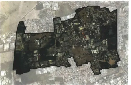
Fig. 1 The western periphery of Ahmedabad 3
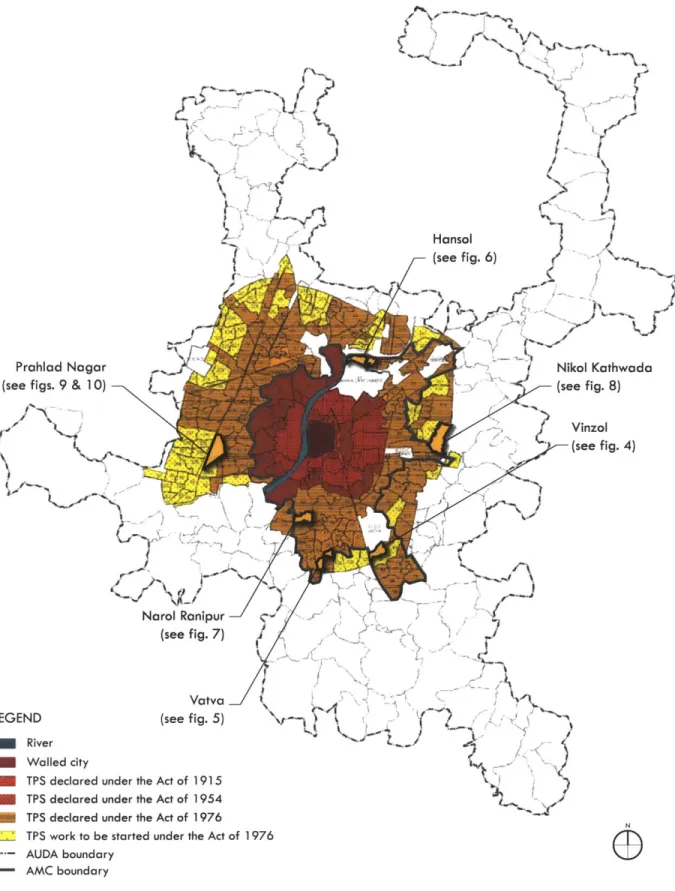
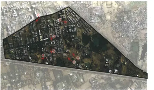
Fig. 2 Town planning schemes in Ahmedabad over the years 23
Fig. 3 AUDA's proposed land use plan for 2011 31
Fig. 4 Vinzol II TP scheme, showing the process of plot 35
reconstitution
Fig. 5 Vatva VII TP scheme, comparing final plot values estimated in 40 TP scheme with observed market prices
Fig. 6 Hansol TP scheme 45
Fig. 7 Narol Ranipur TP scheme 46
Fig. 8 Nikol Kathwada TP scheme 47
Fig. 9 Prahlad Nagar TP scheme 48
Fig. 10 Prahlad Nagar -photographs 49-50
Fig. 11 The process by which housing is added to the urban periphery 54 in Ahmedabad
Fig. 12 Scenes from a landowners meeting 60
Fig. 13 The TPO consulting with landowners 61
Fig. 14 Chalk lines demarcating the new plots 61
Fig. 15 New TP schemes prepared to accommodate the ring road 64
Fig. 16 The completed Sardar Patel Ring Road 64
Fig. 17 Ghuma's landowners outside the AUDA office 67
Fig. 18 Public housing for low-income households built by AUDA on 69
land from TP schemes.
Fig. 19 Residential property price index of cities in relation to their 73
own 2007 prices
Fig. 20 Percentage of population living in slums in Indian cities with 74 total population greater than 1 million
GLOSSARY OF ABBREVIATIONS
AMC AUC AUDA DP DP-TPS EPC GMADA GTPUDA JNNURM MMRDA SNP sq. ft. sq. km. sq. m. sq. mi. TP TPO TPS TPVD TUDAAhmedabad Municipal Corporation Ahmedabad Urban Complex
Ahmedabad Urban Development Authority Development Plan
Development Plan -Town Planning Scheme
Environmental Planning Collective
Greater Mohali Area Development Authority
Gujarat Town Planning and Urban Development Act Jawaharlal Nehru National Urban Renewal Mission Mumbai Metropolitan Region Development Authority Slum Networking Project
square feet
square kilometers square meters square miles Town Planning
Town Planning Officer Town Planning Scheme(s)
Town Planning and Valuation Department Trichur Urban Development Authority
A NOTE ON TERMINOLOGY
The Town Planning (TP) Scheme mechanism is a type of "land pooling", "plot reconstitution" and/or "land readjustment" mechanism. According to Archer (1992), among other differences, "land pooling/ readjustment" projects recover costs through the sale of land only, while "plot reconstitution" projects recover costs through a betterment charge. As TP schemes do both, by this definition they would be considered a hybrid of the two. However, elsewhere, Archer himself makes a different distinction (1999), saying that the difference between "land pooling" and "land readjustment" is that in land pooling, the land is legally consolidated before being reconstituted and redistributed to the original landowners, whereas in land readjustment land is only notionally consolidated, making TP schemes a type of land readjustment. Given the inconsistent nature of these distinctions, this text uses the terms interchangeably. When discussing the use of land readjustment in different parts of India, the local terminology is generally used (eg. "Land Pooling Schemes" in Punjab).
The terms "slum" and "informal settlement" are used interchangeably. Unlike in the United States, the term "slum" is used in a non-pejorative sense in India (for example by the National Slum Dwellers Association.)
Chapter 1
INTRODUCTION
As India urbanizes, its national, state and local governments have been trying in a variety of ways to address the challenge of acquiring land and providing infrastructure to accommodate urban growth. India is expected to remain predominantly rural in the near future, but even the anticipated shift from 30% urban (340 million people) in 2008 to 40% urban (590 million people) by 2030 will require the construction of "a new Chicago every year" in terms of commercial and residential space in cities (McKinsey Global Institute 2010). The Town Planning Scheme mechanism, as used in Ahmedabad in the western state of Gujarat, has received national attention in recent years as a relatively inexpensive, uncontentious, and equitable means of expanding urban infrastructure. This thesis tries to understand how this process works, who benefits from it, and how.
Gujarat is one of India's most urbanized states.' Its urban population is 25 million, 44% of its total population (McKinsey Global Institute 2010). Gujarat is also one of India's more prosperous states, with both a total GDP and a per capita GDP in the top 5 out of 35 states and union territories (VMW Analytic Services). Ahmedabad is Gujarat's largest city, and it is growing rapidly. Its population is estimated to have increased from 2.5 to 6.5 million people between 1981 and 2011 (AUDA and AMC 2006). The physical expansion of the city to accommodate this population growth has been largely achieved using TP schemes.
1 Only Tamil Nadu has a higher rate of urbanization (53%), with the urbanization rate of Maharashtra, Gujarat's neighbor to the south, roughly equal to that of Gujarat (McKinsey Global Institute 2010).
TP schemes are a form of land readjustment, a process not unique to India. Variants of it have been used extensively in Germany, Japan, Korea, Taiwan, Australia, and elsewhere. The TP scheme version of land readjustment has a long history in Ahmedabad, but has been used particularly extensively in the last decade. In order to implement a town planning scheme, agricultural landowners at the urban fringe are required to give up part of their land, up to 40%, to the government, in exchange for a compensation. The government builds roads and other civic amenities on a portion of this land, and sells a portion on the market in order to raise revenues. The remaining land is reconstituted into new plots, which are returned to the original landowners. The landowners sell their serviced plots on the market, and usually receive a high price from real estate developers. They pay half of the increase in value of their land to the government as a betterment charge, while the remaining increase is theirs to keep. According to the proponents of TP schemes, both landowners and the government benefit, making it a 'win-win' proposition.
TP schemes are sometimes thought of as a new innovation, but in fact were introduced to India in 1915 by the British colonial government. Their use continued after Indian independence, but diminished as local and state governments began to view them as overly time-consuming, complex and expensive. In the late 1990s, key changes were made to the enabling legislation in Gujarat, which allowed TP schemes to be prepared more quickly, and allowed the government to earn profits through the sale of land on the market. Chapter 2 traces this history.
Development Plan (DP), a periodically updated master plan for the city which is meant to frame the implementation of TP schemes in a larger strategy of urban growth, but which is subject to many of the criticisms that have caused the practice of master planning to fall out of favor. The subsequent sections find that although landowners and government bodies benefit financially from TP schemes, the way they function on the ground differs significantly from the idealized procedure laid out in the law: the original landowners are often not poor farmers, the calculated land values do not match actual market values, and implementation often suffers from long delays.
While TP schemes are often lauded for being democratic and inclusive, mechanisms for public participation in the DP-TPS process are found to be lacking, as chapter 4 explores. As a collective action problem, land readjustment necessitates some degree of power to withstand holdouts. Still, in keeping a controlling grip on the process, the government risks losing the trust of the landowners it claims to benefit through TP schemes, trust that is vital for the replicability of the process.
TP schemes are also promoted as a source of land for low-income housing, a claim that is investigated in the following section. Land reserved for low-income housing often ends up being used illegally for other purposes. Land from TP schemes is also used for slum rehabilitation, but when informal settlers relocated from other parts of the city are given land in TP schemes, the resettlement process is usually severely unfavorable to the resettled households. Litigation surrounding TP schemes reveals a tendency of the courts to rule in favor of authorities and against individual landowners, evoking the public good in their
rulings.
Variations of the Gujarat model have been used, with various degrees of success, in other Indian states, as chapter 5 describes. Some of these variations can act as test cases, helping us to understand what changes might be beneficial to the mechanism.
The thesis concludes that while Ahmedabad's use of the TP scheme mechanism has not been perfect, as long as its limitations are understood, it should continue to be one of the tools available to local governments in India. It suggests alternative institutional arrangements which, with a larger role for landowners, could help make the mechanism more flexible and efficient, and bring the potential of TP schemes, as a better way for cities to grow, closer to becoming a reality.
Chapter 2
HISTORY
2.1 Origins
The town planning scheme mechanism was first introduced under the Bombay Town Planning Act of 1915. At the time, the British colonial government was trying to use town planning principles to combat plague epidemics, which had been killing thousands of city-dwellers each month. The causes of the spread of plague had not yet been identified, and colonial authorities placed the blame on living practices in the "insanitary labyrinths" of the native city. "Improvement trusts" were created, beginning with the Bombay Improvement Trust in 1898, in order to carry out large-scale demolitions that would bring light and air into cities. The trusts were granted sweeping powers of land acquisition and demolition in order to ventilate cities. These were unpopular with local landowners, who received little or no compensation for land appropriated from them. When an improvement trust built a road, it acquired the adjacent land as well, so that it was the trust itself and not the original landowners who enjoyed the benefits of the new infrastructure. Local anger at the trusts manifested itself in riots, particularly when religious buildings was demolished (Home 1997; Home 2002).
However, by the 1910s, the British colonial government's attitude towards its Indian subjects was starting to change. The Government of India Act of 1909 (the "Minto-Morley reforms") had allowed Indians to be elected to certain legislative positions for the first time.
While these reforms were limited, they suggest that the British government was beginning to feel the need to give Indians at least a token participatory role in the governance of their country. In the same decade, tens of thousands of Indian soldiers fought and died alongside their British counterparts on the battlefields of World War I. The news of the Indian soldiers' heroism, broadcast around the world through newspapers and the new medium of radio, won respect for the nation, and is said to have altered the relationship between Britain and India (Brown 1994; Robb 2002).
It was against this backdrop that the Bombay Town Planning Act of 1915 became the first act related to town planning to be passed in India (Mirams 1919). Unlike the land improvement trusts, the 1915 act acknowledged the interests of the local landowners, and used benefits to them as a selling point. Devised by Arthur Edward Mirams, the Consulting Surveyor to the Bombay Presidency, the 1915 act was "a sincere attempt to embody in one measure all that was best from every other Town Planning Act extant" (Mirams 1919). The Town Planning Scheme process outlined in the act combined elements of the English Housing and Town Planning Act of 1909, which dealt with land use zoning and land reservation, and the German Lex Adickes, which dealt with land readjustment (Mirams 1919; Archer 1992).
First proposed by Franz Adickes, the Burgermeister or Mayor of Frankfurt, the Lex Adickes of 1902 allowed the municipal government of the city to acquire, pool, reconstitute and then return private plots of land, retaining up to 40% of the area for streets and parks (Mullin 1976). While the Lex Adickes is often considered the founding land readjustment
legislation, a very similar policy had in fact been used by George Washington over a century earlier, in 1791, as a means of acquiring land to carry out L'Enfant's plan for Washington, DC (Caemmerer 1939; Schnidman 1988; Home 2007). The notion of land readjustment thus predates not just the modern Indian city, but the emergence of modern town planning as well.
A.E. Mirams, the man who introduced the concept to India, was known as a sort of
evangelist for the cause of town planning in the British colonies. He had traveled the Indian subcontinent presenting lectures and slideshows on the merits of the 1909 English Housing and Town Planning Act, efforts that have been described by a historian as enthusiastic, but isolated and "rather amateurish" (Meller 1994). Mirams was also a social reformer: in 1917 he conducted a wide-ranging "social survey" of industrial workers in Bombay, hoping to convince government and industry leaders that improving the quality of life of workers would not only improve industrial productivity, but was also an important objective in itself (Aspengreen 2010).
Mirams described the new town planning act that he had devised for Bombay in the following terms:
[T]he Bombay Town Planning Act aims at distributing the cost of development schemes over the lands improved thereby, and yet at the same time allows a fair margin of profit to the owners of the land, who as a rule have done absolutely nothing to improve the value of their property. At the same time, the Act brings into the market large areas of land which without
cooperative action would for untold years remain agricultural land. In this way the community at large is able to obtain land at a reasonable price. (Mirams
1919)
Mirams himself acted as an arbitrator for some 60 Town Planning Schemes, explaining the process to landowners and addressing their concerns and requests. He described the Bombay act as "a magnificent thing", which left the landowners "intensely pleased", their attitude transforming "from possible open hostility to undisguised gratitude for benefits conferred"2 (Mirams 1919; Mirams 1923-24).
The Town Planning Act was first applied to Salsette Island in Bombay. The first town planning scheme was prepared for 7 acres (3 hectares) in Bandra. The practice was soon extended to the rest of the Bombay Presidency, which included parts of today's Maharashtra and Gujarat. The TP scheme for Pune was much larger, covering 1500 acres (over 600 hectares). The first TP scheme for Ahmedabad was prepared in 1917, for Jamalpur
(Adusumilli 2009).
In 1919, Mirams was invited to speak at the Town Planning Institute in England about the Bombay Town Planning Act. In the audience discussion that followed, town planners at the institute remarked that TP schemes were preferable to land acquisition because they were more participatory; that estimating future post-improvement land values would be
2 Looking back later, as a Town Planning Adviser to the Government of Uganda in 1930, Mirams seems to have considered the Bombay act too generous, describing the sharing of the benefits a "sop in the pan", i.e. a way to make the schemes more palatable to the landowners. For the planning of Kampala, Uganda, he recommended doing away with this "gratuitous" benefit and charging the entire increase in land value to the owner (Mirams 1930).
difficult; and that arbitrators (now called Town Planning Officers) had a high degree of discretionary power. The fact that these are largely the same observations made about TP schemes today suggests that the mechanism has not changed very substantially in the last century. The major differences between the mechanism then and now are that TP schemes under British rule were not prepared as part of a larger Development Plan for cities as they are today, and that there was no provision then for the use of acquired land for low-income housing. Even the financing of the scheme through the acquisition of land by the
government for re-sale at a higher price, often thought of today as an innovation of the 1990s, was described by Mirams in 1919 in relation to a scheme for Ahmedabad (Mirams
1919).
The early history of TP schemes demonstrates that while some modifications have been made in the intervening century, the town planning schemes being prepared today continue to follow a template laid down nearly a century ago, by very different institutions operating in an entirely different context.
2.2 TP schemes after Independence
The Bombay Presidency continued to prepare town planning schemes over the course of the next several decades. After India achieved Independence from Great Britain in 1947, the Presidency was reorganized into Bombay State, which passed a new Bombay Town Planning Act in 1954. The relatively modest scope of individual TP schemes and the fact that cities were not mandatorily required to prepare them were considered limitations of the 1915
Act. The 1954 act aimed to address these limitations. It made it mandatory for cities to prepare a development plan for its entire jurisdiction, with town planning schemes remaining an optional tool to fill in these larger plans bit by bit. Like the pre-Independence town planning act of 1915, the 1954 act too was based on British legislation, the Town and Country Planning Act of 1947. As a result it has attracted criticism for borrowing unquestioningly from the colonizing foreign culture, instead of emerging from a "ground level understanding" of local urban problems (Menon 1997; Ballaney 2009).
Bombay State was split into Maharashtra and Gujarat in 1960, and each state passed its own town planning act. The Maharashtra Regional and Town Planning Act was passed in
1966, and the Gujarat Town Planning and Urban Development Act (GTPUDA) in 1976. As
urbanization was now beginning to spill over municipal boundaries, both these Acts emphasized a regional approach to planning, with the creation of Development Authorities, such as the Ahmedabad Urban Development Authority (AUDA), to manage the growth of entire metropolitan regions. Maharashtra continued using TP schemes for a few years, but
by the 1980s they had gained a reputation as overly complex, time-consuming and
contentious, and despite several proposals for amendments to the act, TP schemes fell out of use in Maharashtra?
The Gujarat act differed from the Maharashtra one in important ways. The process of preparing TP schemes in Gujarat was split into three stages, with each of the three -the draft scheme, preliminary scheme, and final scheme - requiring approval by the state government.
3 See chapter 5 for a more detailed history of TP schemes in Maharashtra.
In order to address the long delays that regularly occurred as financial matters were resolved, the GTPUDA "de-linked" physical and financial considerations. This allowed implementation to begin once the physical layout had been decided upon, without waiting for financial matters to be sorted out. Still, in Gujarat too, delays were the norm, with some schemes taking over 20 years for completion (Ballaney 2009). They were also far from being self-financing: in 1986, the World Bank estimated that 50-90% of total costs were subsidized
by the government (Baker 1992). TP schemes began to fall into disuse in Gujarat as they had
in Maharashtra. Authorities began to reserve land for public purpose using the development plan itself, bypassing the entire TP scheme process altogether.
This was until TP schemes were revived by AUDA in the late 1990s, when 47 new schemes were prepared as a means of assembling land for a new ring road around the city, a pet project of AUDA chairman Surendra Patel. The original idea had been to simply take the land from farmers in exchange for a minimal compensation as per the Land Acquisition Act
of 1894, but the idea had proved very unpopular, and TP schemes were seen as a potentially
more acceptable alternative. AUDA officials are said to have personally built trust among the affected landowners, convincing them to give up their land earlier in the process so that
AUDA could begin building the road (Ballaney 2009; Ballaney and Patel 2009; Vaidya 2011).
More than 80% of the 47 mile (76 km) long ring road was acquired through TP schemes, with landowners giving up portions of their land "by consent", receiving no compensation in return (AUDA 2007). As we will see in section 4.2, how consensually this really happened can be seriously questioned. In any case, the ability of AUDA to take possession of land for
road-building earlier in the process was formalized in amendments made to the GTPUDA in
1999. This allowed faster implementation of subsequent schemes, and is one of the changes
credited with granting new life to the TP scheme mechanism in Ahmedabad (Patel, V. 2011). The other key change made at this time allowed authorities to appropriate land to sell on the market. As mentioned above, this had been described as far back as 1919 by Mirams as a means of cost recovery. It had also been practiced for many years as a part of land readjustment in other countries like Japan, South Korea and Taiwan (Doebele 1982), and proposed for use in Gujarat by the World Bank and others during the 1980s (1985; Vaidya
1986). This change was finally made to the GTPUDA in 1999, and it was then that town
planning schemes finally became financially viable for local governments in Gujarat (Patel, B. 2011).
The applicability of the mechanism to disaster relief was demonstrated when the historic core of Bhuj, a town in Gujarat 200 miles (330 km) west of Ahmedabad, was destroyed by an earthquake in 2001. The area was replanned and rebuilt using eight new TP schemes prepared by the Environmental Planning Collective, an Ahmedabad-based planning organization (Ballaney 2009).
J
Hansol (see fig. 6)
Prahlad Nagar (see figs. 9 & 10)
L~ Narol Ranipur
(see fig. 7)
Vatva J \
LEGEND (see fig. 5) N
River Walled city
TPS declared under the Act of 1915 TPS declared under the Act of 1954 TPS declared under the Act of 1976
TPS work to be started under the Act of 1976 AUDA boundary
- AMC boundary
Source: Adaptedfrom Ballaney (2008)
Fig 2: Town planning schemes in Ahmedabad over the years
Vinzol (see fig. 4)
---2.3 TP schemes today
The use of TP schemes for the expansion of Ahmedabad into the surrounding region continues. The Ahmedabad Municipal Corporation (AMC), finding its internal capacity insufficient, has been outsourcing the drafting of TP schemes to private mapping, surveying and urban planning firms for the last decade, while AUDA continues to prepare TP schemes in-house for the surrounding region (Patel, V 2011).
The pace of expansion using TP schemes has increased since the turn of the century. Between 2000 and 2009, AMC and AUDA developed over 77 sq. miles (200 sq. km.) of land using TP schemes, as opposed to only half that area in the preceding 25 years (Annez, Bertaud et al. 2010). As of late 2009, around 100 schemes under AMC and another 100 under AUDA had been prepared or were underway, with another 200 envisioned under the 2002 development plan (Ballaney 2009). AUDA's website boasts that "100 TP Scheme means Land & Infrastructure Provision for 15 Lacks [1.5 million] People." It has been estimated that the average area developed each year in Ahmedabad is around three per cent of AMC's already built-up area. Between 2005 and 2010, AUDA also built over 11,000 units of low-income housing using land obtained through TP schemes (Nair and Ahluwalia 2010a).
The sale of land obtained through TP schemes has become an important source of income for AUDA. Between 2001-02 and 2004-05, AUDA's total capital budget increased sevenfold, from ?32 crore to Z227 crore' (US$ 7 million to US$ 50 million). On average,
4 Z is the new symbol for the Indian rupee, adopted by the Indian government in 2010. As of 2011, 1 US$ Z45. 1 crore = 10 million.
between 2003-04 and 2008-09, 29% of AUDA's revenue came from the sale of land. In April
2006, AUDA auctioned 20 plots for Z172 crore (US$ 38 million), to large real estate firms.
In that year, 65% of AUDA's revenue came from land sales. The proceeds from land sales have been used by AUDA to finance large infrastructure projects, mostly road development, water supply, sanitation, drainage, etc (Mahadevia 2009; Sridhar and Reddy 2009). A recent development plan states that from 24 schemes, AUDA has created a land bank worth Z500 crores, i.e. over US$ 100 million (AUDA/ AMC City Development Plan 2006-2012).
Although some other states have experimented with similar legislation, none of them has used TP schemes as extensively as Gujarat has. With the growing pressure on urban land in Indian cities, several states have shown a renewed interest in TP schemes, perceiving them to be a financially and politically superior alternative to land acquisition, and a relatively fast way of expanding urban infrastructure into the surrounding landscape (see chapter 5).
Chapter 3
RULES AND REALITIES
53.1 The Development Plan
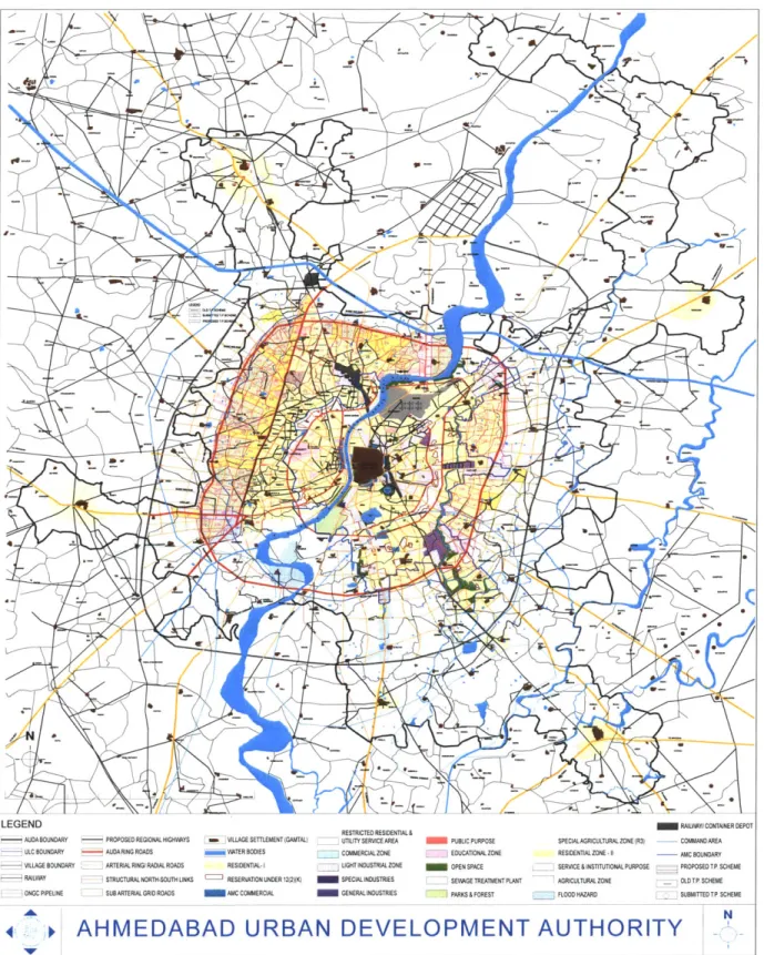
Town planning schemes are part of the two-step Development Plan - Town Planning Scheme (DP-TPS) process. Every ten or so years, AUDA prepares a development plan (DP) for the entire metropolitan region, intended as a "comprehensive strategic document for the development of the city" (Ballaney and Patel 2009). The DP attempts to address a variety of issues, such as infrastructure development, transportation, heritage protection, economic development, and environmental protection and land use zoning.
The development plan includes a land use master plan, which identifies areas of future expansion of the city into the surrounding agricultural region, in anticipation of estimated population growth. Once areas have been identified for future expansion, they are rezoned in order to be "opened up" for non-agricultural uses (residential/ commercial, industrial, institutional, etc.). For example, a version of the 1999 DP designated around 39 sq. miles
(100 sq. km., an area more than five times the size of Cambridge, Massachusetts) of
additional land in the Ahmedabad metropolitan area to be developed by 2011 (Environmental Planning Collective 1999). These newly urbanizable areas are then divided into smaller areas of 250-500 acres (100-200 hectares), usually encompassing land owned by
5 Chapters 3 and 4 make reference throughout to the written work of Ahmedabad-based planners Shirley
Ballaney and Bimal Patel (Ballaney 2008; Ballaney 2009; Ballaney and Patel 2009). Information was also gathered through interviews with them, as well as with Vatsal Patel (AMC) and R.B. Joshi (AUDA) in
100 to 250 landowners, for which more detailed physical plans are prepared. These are the
Town Planning Schemes.
This kind of large-scale land use master planning has been the subject of much criticism in planning literature. It is now often considered by many to be a relic of early 2 0th century Modernist planning, which has fallen out of favor in the Western countries of its origin and lives on only in developing countries. It has been suggested that the reason for the persistence of master planning is that government officials in the developing world use their control over land resources as a source of power. According to the UN Human Settlements Program (2009) "Planning can be used as a 'tactic of marginalization', where particular ethnic or income groups are denied access to planning services and are then marginalized or stigmatized because they live in informal or unregulated areas."
Some of the major criticisms of the master plan approach as adopted by Indian cities are the following (Tiwari 2002):
- Detailed land use plans are static and inflexible, projecting a desired long-term end state without paying enough attention to short- and medium-term action or mid-course corrections that may be required.
- The preparation and approval of master plans is very time-consuming. - Obtaining land in order to implement these plans is usually difficult.
- Public participation in master plans is ineffective, resulting in a top-down approach.
socio-economic variables, housing prices and availability, and environmental conditions. There is usually no system of continuous data collection in place. - Physical standards for the built environment are impractically high, making
developments unaffordable to the poor.
- Insufficient attention is paid to financial strategies needed to implement the plan.
Physical order is overemphasized, while social, economic and institutional development is neglected.
- The master plan does not account for the role of the private sector in implementation.
- Regulations are usually not complied with or enforced.
- Once prepared, plans are often not implemented. There is no system in place to monitor and evaluate the implementation of plans over time.
According to the UN Human Settlements Programme (2009),
Some 2000 Indian cities now have master plans, all displaying the problems that caused countries such as the UK to shift away from this approach, and yet the main task of municipal planning departments is to produce more such plans... Recently, the growing criticism of the master plan in India led the Ministry of Urban Development to organize a national conference on the theme of Alternatives to the Master Plan. After extensive discussions and
debates extending over three days, the meeting concluded that the only alternative to the master plan is a 'better' master plan.
TP schemes have allowed Ahmedabad to avoid some of the land acquisition difficulties mentioned above, but most of the criticisms of master plans could be leveled at Ahmedabad's development plan as well. The city's DP has been criticized in particular for its lack of analytical rigor and transparency in designating areas of future growth. Population growth estimates for an area are arrived at using trend-based statistical projections. This means that the population in an area is expected to continue growing at the rate it has been, regardless of the location of the area in the city, anticipated job growth, socioeconomic character, transportation infrastructure, housing supply, etc. Such estimations of population growth in previous DPs have proven significantly inaccurate, generally overestimating growth in secondary centers and underestimating growth in the central agglomeration of the city (see table 1). Even once population estimates have been arrived at using these methods, the relationship between these projections and the corresponding rezoning of land is not fully explained (Adhvaryu forthcoming).
The DP land use plan has also been criticized for not sufficiently allowing mixed uses, and for not paying enough attention to informality in the public realm (Kleinenhammans
2009). 6
6 Public participation concerns relating to the DP are discussed in section 4.1. 29
Table 1: Comparison of populations projected in the DP and measured by the census
1991 2001
Areas % Diff. % Diff.
Projected Census Census v. Projected Census Census v.
Projected Projected A. AMC 3,113,335 2,876,710 -7.6% 3,704,633 3,520,085 -5.0% B. AUC 3,530,035 3,437,663 -2.6% 4,601,456 4,458,215 -3.1% C. AUC-AMC 416,700 560,953 34.6% 896,823 938,130 4.6% D. Urban Centres 1. Kalol-Saij 121,575 92,550 -23.9% 133,040 124,718 -6.3% 2. Dehgam 37.963 31,378 -17.3% 43,680 38,082 -12.8% 3. Sanand 32,770 25,674 -21.7% 39,537 32,417 -18.0% 4. Mehmedabad 34,465 26,103 -24.3% 44,049 30;768 -30.2% Total (D) 226,773 175,705 -22.5% 260,306 225,985 -13.2% E. Rest of ALDA 607.380 268,102 -55.9% 607,380 286,163 -52.9% AUDA (B+D+E) 1 4,364,188 3,881,470 -11.1%
[
5,469,142 4,970,363 -9.1%[AUC = Ahmedabad Urban Complex, i.e. the Ahmedabad agglomeration excluding secondary population
centers and rural areas]
LEGEND
AUDABOUNDARY PROPOSED REGIONAL HIGHWAYS a ]VILLAGE SETTLEMENT(GANTAL) ULC BOUNDARY AUDA RING ROADS WATER BODIES
- VILLAGE BOUNDARY ARTERIAL RING RADIAL ROADS RESIDENTIAL-I
- RAILWAY STRUCTURALNORTH-SOUTH UNKS RESERVATON UNDER 12(2)K)
ONGC PIPELINE SUBARTERIAL GRID ROADS AMC COMMERCIAL
4.
RESTRICTED RESIDENTIAL& UTiLITY SERVICE AREA
-COMMERCIALZONE LIGHT INDUSTRIAL ZONE SPECIAL INDUSTRIES GENERAL INDUSTRIES
PUBLIC PURPOSE EDUCATIONALZONE OPEN SPACE
_ SEWAGE TREATMENT PLANT
I PARKS & FOREST
SPECIAL AGRICULTURAL ZONE (R3)
RESIDENTIALZONE -1 SERVICE&INSTITUTIONAL PURPOSE
AGRICULTURAL ZONE
FLOOD HAZARD
AHMEDABAD URBAN DEVELOPMENT AUTHORITY
Source: AUDA/ AMC Ciy Development Plan, Abmedabad 2006-2012.
Fig 3: AUDA's proposed land use plan for 2011
RAILWAYICONTAINER DEF COMMAND AREA AMC BOUNDARY -- PROPOSED TP SCHEME OLDTP SCHEME SUBMITTEDTP SCHEME
3.2 The Town Planning Scheme mechanism: as prescribed
The Town Planning Scheme mechanism has been described as a planning, infrastructure development, implementation and financing tool all in one, and is used to fill in the details of the DP. The following is a brief account of how TP schemes are supposed to work, as prescribed by the 1976 GTPUDA and subsequent amendments.
After conducting the necessary surveys and documenting the ownership of the agricultural land that is affected by a new TP scheme, the agency under whose jurisdiction the area falls (AUDA or AMC, see fig. 2) designs a draft plan for the scheme. The plan shows the location of proposed roads, which take up 15-20% of the total area under consideration, as well as other amenities like parks, low-income housing, schools, "neighborhood centers", land to be sold by the government on the market, etc., all of which together take up another 15-20% (see table 2). The remaining 60-70% of the land is retained
by the original owners, with the same proportion of land deducted from each plot of land.
That is, if 35% of all the land is used by the government for infrastructure and amenities, the plot of each landowner in the area is reduced by 35%.
This is achieved by reshaping the plots to suit the new plan, which is known as plot reconstitution. The reconstituted plots, besides being smaller by 35-40%, are altered to fit the new scheme. This usually means reshaping them to be more rectangular than the irregular original agricultural plots, as regularly shaped plots are considered more "buildable". An attempt is typically made by the planners to keep each final plot (FP) in
roughly the same location as the original plot (OP) 7, but there is still always some exchange
of ownership required. This process of plot reconstitution generally does not apply to officially recognized village settlements, only to the largely open agricultural land surrounding them. When a village falls within the area of a TP scheme, it is left alone, either with a road built around it, or with the roads within it integrated into the new surrounding road network.!
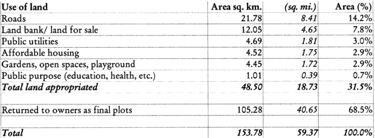
Table 2: Land appropriation in 103 TP schemes prepared by AUDA since 2002 Use of land
Roads
Land bank/ land for sale Public utilities
Affordable housing
Gardens, open spaces, playground Public purpose (education, health, etc.)
Total land appropriated
[iReturned to owners as final lots
Total
Area sq. km.l
21.78 12.05 4.69 4.52 4.45 1.0148.501
105.28 153.78 (sq. mi.) Area (%) 8.41 14.2% 4.65 7.8% 1.81 3.0% 1.75 2.9% 1.72 2.9% 0.39 0.7%1 18.73 31.5% 40.65 68.5% 59.37 100.0%,Source: Adapted from Ballaney (2010)
Three versions of the scheme are prepared: the draft, preliminary and final schemes,
7 According to Shirley Ballaney, a planner who has acted as a private consultant to AMC on the preparation of TP schemes, the unofficial rule of thumb that has usually been followed is that 75% of the FP should overlap with the OR
8 This appears to be a convention of practice rather than a regulation of the GTPUDA, which only states, "A
town planning scheme may be made... in respect of any land which is (i) in the course of development; (ii) likely to be used for residential or commercial or industrial or for building purposes; or, (iii) already built upon" (Government of Gujarat 1976).
each of which needs to be sanctioned (approved) by the state government. Consultations with the affected landowners are held at various stages (see chapter 4). The government is allowed to take possession of land needed for the construction of roads after the state sanctions the draft scheme. The ownership of all other plots is considered to be transferred to the government after the preliminary scheme is sanctioned, at which point the construction of other amenities may begin. The subsequent changes, made between the preliminary and the final scheme, relate only to financial matters. The Act allows a total of four years and one month for the preparation of a TP scheme, from the initial declaration of intention to the sanction of the final scheme.
Finances are dealt with as follows: An assessment is made of the financial value of each original plot prior to the scheme, based on recent land sales. The government owes each landowner some amount of money for the portion of land it has appropriated from them (the 35-40% mentioned above), based on these original plot values. At the same time (before actual construction of infrastructure), an estimate is also made of the future value that each plot will achieve once all the infrastructure has been built. The difference between the original plot value and final plot value, i.e. the increase in land value or "increment" that comes about through government action, has been attained by the landowner through no effort of his or her own. The landowner therefore owes the government a betterment charge for this improvement, amounting to 50% of this increment. The idea here is that the financial benefit of the scheme is split down the middle between the government and the landowner.
LEGEND
Sale for Residential Sale for Commercial Garden Social Infrastructure
Low Income Housing
TP Scheme Boundary
Source: Adaptedfrom Ballaney & Patel (2009)
Fig. 4: Vinzol II TP scheme, showing the process of plot reconstitution
So the government owes the landowner compensation for land taken, and in turn the landowner owes the the government a betterment charge. The difference between the two amounts is calculated, and this balance is paid in the direction required. For example, if the betterment charge exceeds the compensation, which is usually the case, the landowner must pay this excess amount to the authority, in installments over ten years.
A hypothetical example may be useful here in order to illustrate this somewhat
complicated process. (The values used in this example are comparable to actual observed values). Let us imagine that a farmer, Mr. X, owns a plot of agricultural land of 1,000 square meters on the periphery of Ahmedabad. His plot falls within the boundaries of a new TP scheme being prepared by AMC. AMC assesses the value of this plot to be Z200 per sq. M., i.e. ?200,000 in total. While preparing the TP scheme, AMC decides that 40% of land will be taken from each plot, which means that it takes 400 sq. m. of land from Mr. X, which is worth 780,000 in compensation. So AMC now owes Mr. X T80,000. 600 sq. m. of land, worth ?120,000, remains with Mr. X. AMC estimates that once the improvements have been made, the value of the land in Mr. X's reshaped final plot will increase from 7200 to Z500 per sq. M., i.e. the total value of his land will increase from ?120,000 to ?300,000. The improvements have thus caused the value of his remaining land to go up by 7180,000. In order to share this benefit with the government, he now owes 50% of this, ?90,000, to AMC as a betterment charge, which goes towards AMC's project costs. Since AMC already owed him Z80,000 for the land it originally took, his net payment to AMC is Z10,000. The other
above are accurate, in total Mr. X is ?90,000 better off than he was before.
TP schemes are frequently described as a "win-win" proposition (Ballaney 2008; Kleinenhammans 2009; The Hindu 2010). Small agricultural landowners at the urban fringe get to keep the majority of their land as infrastructural improvements are made, and then sell the improved land to developers at a high price. This is seen as more favorable to farmers than simply appropriating all their land under the Land Acquisition Act, for a compensation
that is often considered unfair (Lahiri 2010).
While the landowner's value goes up under TP schemes, the government agency also is able to recover its costs through betterment charges and through the sale of land. The government also benefits by not having to pay either the financial or the political costs of the kind of direct land acquisition described above (CITYNET 1995). TP schemes are also visually orderly compared other forms of urban growth in India, which are perceived as haphazard. More broadly, TP schemes have been seen in the context of proposed supply-side solutions to formal housing shortages in Indian cities (see section 4.3).
3.3 The Town Planning Scheme mechanism: as practiced
The reality of preparing TP schemes differs from the idealized version described above in several important ways.
To begin with, the owners of land at the urban fringe are not necessarily the poor rural farmers that TP schemes appear to benefit. While there is no documentation of the landowners' backgrounds or incomes, officials, planners and developers in Ahmedabad
believe that in many cases the real owners are speculative land assemblers, developers, businesspeople, and even politicians and bureaucrats (Chakravarti 1999; Ballaney 2011; Joshi 2011). Under the Bombay Tenancy and Agricultural Lands Act, 1948, land in Gujarat and Maharashtra designated as agricultural land may only be sold to an "agriculturist" (Lands of Maharashtra), but it appears that either the definition of who qualifies as an agriculturist is loose, or people who are not farmers gain control of land by securing power of attorney. Land assemblers are even believed to routinely forge documents, falsify power of attorney and duplicate sales records in order to acquire the rights to land without the knowledge of the rightful owners. Hundreds of such cases of fraud have been filed in recent months ("265 land-grabbing cases in Ahmedabad dist", Times News Network 2011). As a result of all of the above, actual farmers may not benefit as greatly by TP schemes as is usually claimed.
A second key difference between the rules and realities of TP schemes is in the finances.
The entire process of financial evaluation described in the previous section is essentially a pretense; neither the assessed original plot values nor the predicted final plot values are even expected to match real land prices. In fact, given the extremely murky nature of land transactions in India, it would be impossible for the government to value land accurately from recent sales.9 Original plot values, instead of being based on recent sales in the area, are based on a standard land "reckoner". The calculation of future, post-implementation values is more of a difficulty, one which has been noted wherever betterment levies are charged
9 Ballaney estimates that in every land sale, 40% of the price is declared and the remaining 60% is paid in cash
under the table, in order to pay lower stamp duties, which are charged each time the property changes hands.
around the world (Peterson 2009).
Instead, the final plot values are determined in a round-about way. The government first predicts the cost of infrastructure (roads, water supply, drainage and street lights) and certain administrative costs. These are calculated according to a standard schedule, which tends to reflect costs of a very low standard of construction, and so does not capture the full costs that actually will be incurred. The government does not expect to even completely recover these unrealistically low costs from landowners, so it decides what portion of the costs it will bear itself, and what balance it will have to recover from landowners through betterment charges. Since the betterment charges are a function of final plot values (as described in the previous section), the final plot values are calculated in order to recover the predetermined betterment charge. In this manner, the process of land "valuation" is really
conducted in reverse.
In reality, the betterment charge comes nowhere close to equaling half of the increase in land value. On the outskirts of a rapidly growing city like Ahmedabad, the real final plot values when sold for development tend to be very high. (The assumption is that the original landowners will always choose to sell their land rather than remain on it).
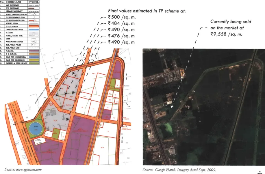
LEGEND:-SR.NO. PARTICULAR 1. ANC BOUNDARY 2. TP8 BOUNDARY a. viz&M BOUIMARY 4. sRnSIT UMuSRT/ulubo. 5. 0.P.SOUNDART/OJ..NO. 5 . F.BUDUND /7F.P.1K. 7. SURVET HEMA S. DP./T.PROAD 0. CANAWWAT BODY 10. H.T.IM 11. PUEUA/KUcNA ST M2. Gan
IS. KVunM EUNDOS
I. fLL/IE POIin I. M./IL LINE LG. N.B.AC.C. 17. 5 & E...H. 1R. RALEFR CUNIOMIL 1S. RALE JNR BESEENC SO. GARDE & WEN SPACE
SYMBOL
/OM
avme
Final values estimated in TP scheme at:
t- 500 /sq. m.
/ T -C484 /sq. m / / Ir- !490 /sq. m
/ r-T476 /sq. m / -C490 T /sq. m
Currently being sold
r - on the market at
/ T9,558 /sq. m.
Source: ww-w. ego vamc.com Source: Google E arth. Imagerj dated Sept. 2009.
Fig. 5: Vatva VII TP scheme, comparing final plot values estimated in TP scheme with observed market prices. The draft scheme as sanctioned in 2006 (left) shows low estimated final plot values. Despite the lack of
Figure 5 illustrates an example of the discrepancy between land values on paper and on the market. The Vatva VII draft scheme was sanctioned by the state government in March
2006. It estimated that after the construction of roads, parks, etc, the final value of the plots
indicated will be Z480 to 500 per square meter. The satellite image suggests that no construction of infrastructure had occurred by September 2009. The preliminary scheme and final scheme have not been sanctioned by the state government (AMC n.d.). Despite this, a plot of land just beyond the boundary of this TP scheme is being advertised on a real estate website at Z9,558 per square meter ("Residential Land in Vatva, Ahmedabad City & East", from 99acres.com). This land is under another TP scheme, which received draft sanction in
1995 but also has not received any subsequent sanctions or seen any construction of
infrastructure. If land prices on the market are 20 times the estimated final plot values even before the schemes are finalized and any infrastructure is laid out, one can imagine that the
discrepancy once the TP scheme is completed will be far greater. Ballaney estimates that whereas a final plot value on paper may be Z500 per square meter, when sold on the market after the TP scheme is complete, the same plot may receive Z20,000 to 60,000 per square meter (Ballaney 2011).
However, even if they do not equal half the increase in land value, betterment charges still do fulfill an important function. By varying the final plot values by some amount to reflect locational advantages and disadvantages, landowners benefiting differentially are differentially burdened with betterment charges. This satisfies landowners that the process is fair. If, for example, one landowner's new plot fronts a major street or is next to a park, his
final plot value (unrealistic as it is) will be estimated at slightly a higher figure than his neighbors, so he will have to pay a slightly higher betterment charge. If another's is next to a low-income housing block or a crematorium, her final plot value will be slightly lower so she will pay a lower betterment charge. This keeps each landowner satisfied that he or she has benefited proportionately to the other landowners (Patel, B. 2011).
The government also does make large sums of money from the schemes, not through betterment charges but through the sale of banked land (as described in section 2.3). This is why the recent practice of land-banking has been so critical, as this is the main source of revenue for the government from TP schemes.
What the above illustrates is that the premise of TP schemes benefiting original landowners while also being self-financing for local governments is actually borne out in Ahmedabad, even if not in the manner intended by the enabling legislation. In fact, both parties benefit much more greatly than originally envisioned when they sell land on the market. However, it is important to understand the origin of this vast increase in value. In the complicated process of land readjustment and valuation described above, it is easy to lose sight of the key fact that as part of the TP scheme, land is being rezoned for urban development. In a rapidly growing city like Ahmedabad, newly available land in the metropolitan area is highly valuable, which guarantees large gains for landowners and government. It is unclear how much of the increase in value is attributable to the infrastructure and amenities built by the government as part of the TP scheme, and how much is simply a consequence of the urban fringe land coming onto the market.
The third difference between legislation and practice is that although the process of preparing the scheme is meant to take only four years and one month, it usually takes much longer. The time taken for the various stages (draft, preliminary and final) to be sanctioned
by the state government is often lengthened indefinitely. Since AUDA first began preparing
TP schemes in 1976, 100 draft schemes have been sanctioned by the state government. Of these, only 25 have gone on to receive preliminary scheme sanction. An average of 7 years passed between the draft and preliminary scheme sanctions (a minimum of 4 years and a maximum of 26 years). The remaining 75, dating back to 1990, have not yet received preliminary scheme sanctions. Only 17 out of the 100 have received final sanction, which
took another 4 years on average after the preliminary sanction (see appendix A).
AMC has prepared 101 schemes, dating back to 1925. 3 schemes prepared between 2007
and 2009 have not yet received draft scheme sanction. 47 schemes have received draft scheme sanction but have not yet received preliminary scheme sanction (mostly from the last decade, but also including several from the early 1990s). 5 schemes have received preliminary but not final scheme sanction. 45 out of the 101 have received the final scheme sanction, of which only 3 have received it since 2000 (see appendix B).
The state government's sanctioning process has been identified as the primary cause of these delays. According to Ballaney (2009), the state's town planning department has a severe shortage of staff and lacks technical capacity, and yet must conduct multiple rounds
of detailed, in-house reviews on hundreds of TP schemes from various cities at the same
It presumes that local capacities are inadequate, that they cannot be developed and that higher levels of government know better. That plans need to be protected from vested interests at local levels is often cited as the main reason why the State Government should have such broad and overarching review and sanctioning powers. Whatever be the merit of this view, it is clear that role of the Development Authority is envisaged as being dependent; a vision that undermines the building of capacity at local levels. (Ballaney 2009)
However, the delays in the preliminary and final sanctions cannot fully explain delays in implementation, as AMC and AUDA are allowed to begin constructing roads after the sanction of the draft scheme itself. Comparing TP scheme layouts and the date of draft scheme sanctions with series of satellite images reveals that infrastructure often remains unbuilt for years after the draft scheme is sanctioned. For example, figure 6.1 shows an aerial image of Hansol in northern Ahmedabad in November 2003. Figure 6.2 shows AMC's draft scheme for the area, which was sanctioned by the state government in September 2004. Figure 6.3 shows the same area in January 2010, over five years later, with a very small amount of road-building appearing to have taken place. Figures 7, 8 and 9 show similar comparisons for other TP schemes.
Fig. 6.1: Hansol in northern Ahmedabad in November 2003, before the draft scheme.
Fig. 6.2: Draft scheme for AMC's TPS no. 67, sanctioned Sept. 2004 (Source: Pate/& Patel 2009)
Fig. 7.1: Narol Ranipur in southern Ahmedabad in October 2003, before the draft scheme.
LEGEND
Sale for Residential Sale for Commercial Sale for Industrial Garden
Social Infrastructure Low Income Housing Existing Structures
Proposed Roads TP Scheme Boundary
Fig. 7.2: The draft scheme for AMC's TPS no. 62, sanctioned March 2005. (Source: egovamc.com)
Fig. 8.1: Nikol Kathwada in eastern Ahmedabad in November 2003, before the draft scheme.
Fig. 8.2: Draft scheme for AUDA's TPS no. 111, sanctioned Dec. 2003 (Source: www.auda.org.in)
Kathwada in May 2010.
Fig. 9.1: Prahlad Nagar in western Ahmedabad in November 2000.
Fig. 9.2: Four draft schemes, sanctioned between February and November 2000, were implemented as a single, model TP scheme. (Source: Patel & Patel 2009)
O
Fig. 10.1: Views of Prahlad Nagar. (Source: Patel & Patel 2009)
Fig. 10.2 (above and facing page): Prahlad Nagar, as photographed in January 2011. Prahlad Nagar is considered a model TP scheme, and is referred to as AUDA's "crowning glory". (Photographs by author)