HAL Id: hal-00936646
https://hal-brgm.archives-ouvertes.fr/hal-00936646
Submitted on 27 Jan 2014
HAL is a multi-disciplinary open access
archive for the deposit and dissemination of
sci-entific research documents, whether they are
pub-lished or not. The documents may come from
teaching and research institutions in France or
abroad, or from public or private research centers.
L’archive ouverte pluridisciplinaire HAL, est
destinée au dépôt et à la diffusion de documents
scientifiques de niveau recherche, publiés ou non,
émanant des établissements d’enseignement et de
recherche français ou étrangers, des laboratoires
publics ou privés.
the Rhine Graben for a better geothermal exploration of
the deep basins.
Chrystel Dezayes, Catherine Lerouge, Bernard Sanjuan, Claire Ramboz,
Michel Brach
To cite this version:
Chrystel Dezayes, Catherine Lerouge, Bernard Sanjuan, Claire Ramboz, Michel Brach. Toward a
better understanding of the fluid circulation in the Rhine Graben for a better geothermal exploration
of the deep basins.. World Geothermal Congress 2015, Apr 2015, Melbourne, Australia. �hal-00936646�
Melbourne, Australia, 19-25 April 2015
Toward a Better Understanding of the Fluid Circulation in the Rhine Graben for a Better
Geothermal Exploration of the Deep Basins
Chrystel Dezayes1, Catherine Lerouge1, Bernard Sanjuan1, Claire Ramboz2, Michel Brach1 1BRGM, French Geological Survey, 3, avenue C. Guillemin, F-45060 Orléans Cedex 2
2 ISTO, Orléans University, 14, rue de la Ferollerie, F-45100 Orléans
c.dezayes@brgm.fr
Keywords: Fractures, fluid circulation, Upper Rhine Graben ABSTRACT
In the Upper Rhine Graben, geothermal projects are strongly under development, particularly for the exploitation of fluid in the deeper part of the basin. This type of reservoirs constitutes a fractured dominated system. However, the hydraulic behaviour of the fracture network is poorly known and its knowledge constitutes an important way to better target the exploration works.
Combining data from structural analysis, mineralogical analysis of fracture filling from outcrops and drilling cores and fluid geochemical analysis from deep boreholes, we propose a new model of fluid circulation in the deeper part of the Rhine Graben. The present-day fluids collected from the basement and the Buntsanstein sandstones in the deepest wells have the same origin and are totally different to those from Tertiary sediments. These deep fluids have reacted with deep sedimentary rocks at about 4 or 5 km depth before migrate through the graben and probably diluted at small proportions with meteoritic freshwaters.
These fluids circulate through a fracture network constitutes by different sets linked to the tectonic history of the Rhine Graben. In the basement, the Hercynian fractures, oriented NE-SW and NW-SE, show two successive stages of fillings showing two fluid circulation pulses: 1) a sheared/cataclased phase associated with illite and quartz, which is prior to the graben opening; 2) precipitation of dolomite in tension fractures linked to the early stage of the graben formation. An other main direction fracture set is present in the basement, probably reactivated, and in the Permo-Triassic sandstones with a N-S direction. On outcrops, this fracture set have no macroscopic mineralogical fillings, but in boreholes and for some large shear zone in the sandstones, a cataclasis phase associated to quartz and illite, and radial illite in tension fracture in the granite, and barite in the Buntsandstein sanstones is present.
This study suggests that the reactivation of old Hercynian structures, oriented NE-SW and NW-SE, in relation with the Tertiary tectonic history of the graben formation develops the fluid/basement interaction in deep temperature conditions. In the contrary, the N-S large structures favor recent circulation system and rather constitute a recharge drain.
1. INTRODUCTION
In France, the geothermal heating production is mainly located in the great basins, such as the Paris Basin, but also the Aquitaine Basin and the Rhine Graben. The geothermal electricity is produced mainly in a volcanic context of Guadeloupe, and also in the experimental site of Soultz-sous-Forêts in the Rhine Graben. In this area, geothermal projects are strongly under development, especially for the exploitation of deep fluid within the top of the basement. Numerous geothermal projects or exploration works are engaged for the exploitation of the deep geothermal energy for electricity or heating production, or cogeneration (electricity+heating).
In the frameworks of the geothermal exploration, we want to better understand the hydraulic behaviour of the fracture network, such as connexion, main fluid flow direction, role of the fault zones versus minor fractures, deformation types (cataclasis, fault, crack…).
For that, we propose to understand the palæo-circulations by studying fracture fillings, their textures and establish mineral sequence of fillings in relation to the tectonic phases and the geological history of the basement and the permo-triassic sandstones. Finally, the goal is to link the palæo-circulation to the present-day circulation by the description of the plugged fracture network and the comparaison of the chemistry of palæo-fluids with those of present-day fluids which flow in the deeper part of the Upper Rhine Graben.
2. GEOLOGICAL CONTEXT
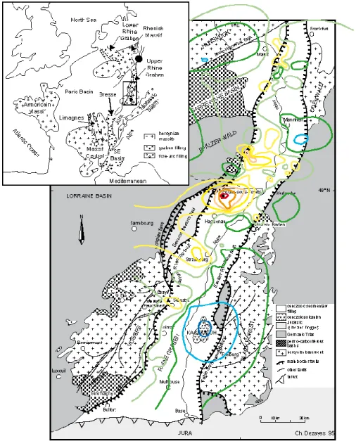
The Upper Rhine Graben is a Cenozoic graben belonging to the west European rift system (Ziegler, 1992), which is very well-known because of numerous studies for petroleum and mining exploration (boreholes, geophysical surveys…). The trough is filling by Tertiary and Quaternary sediments with a rather discrete volcanic activity. This Tertiary cover overlays the Jurassic and Triassic sediments and the Paleozoic crystalline basement (Figure 1).
The crystalline basement has structured during the Hercynian orogeny linked to the NE-SW sutures occurred in the main tectonic phases at the Carboniferous (Sudete phase) and Permian (Saalian phase) (Zieger, 1986; Matte, 1986; Oncken et al., 1999). In the Vosges (Schneider, 1984) and in the western border of graben (Villemin, 1986), these tectonic phases induce brittle tectonic with main fracture sets oriented N45°E, N135°E and N-S for the Carboniferous phase and N60°E to N90°E and N120°E for the Permian
After a large period of sedimentation during Trias and Jurassic with deposition of clastic and carbonate sediments, the area has been uplifted from late Jurassic to early Eocene. The taphrogenesis started at Eocene by a N-S compression. The main phase of opening of the Rhine Graben occurred during Oligocene with an E-W extension. A second tectonic stage occurred during Miocene with a succession of two compressions, NE-SW and NW-SE respectively (Villemin and Bergerat, 1987).
Several local thermal anomalies are present along the western border main fault of the graben located near Obernai, Soultz, Landau (Schellschimdt et al., 2002), which result from the circulation of deep fluids. All these anomalies are located where the direction of the border fault rotates from N20°E to N45°E (Figure 1).
Figure 1: Location and simplified geology of the Upper Rhine Graben. Colored curves indicate isotherm at 1500m to 130°C (red) to 50°C (blue) (data from GGA).
Numerous saline, hot springs and spas (Niederbronn, Morsbronn, Baden-Baden) are present in surface and the experimental EGS project of Soultz exploits the deep geothermal resource of the graben (Genter et al., 2012). These provided evidence of large scale fluid circulations at the deeper part of the basin and down in granite (Pauwels et al., 1993; Aquilina et al., 1997, Sanjuan et al., 2010). The origin of these fluids is common and should be from deep sedimentary reservoir such as lower Triassic at about 230°C (Pauwels et al., 1993). Other authors show a fluid mixing, which suggests a part of meteoritic water from the Vosges massif (Cathelineau and Boiron, 2010).
On the basis of fluid inclusion studies in granite crosscut by the Soultz EPS1 drillhole, the earliest stage of pervasive alteration is characterized by hot moderately saline fluids (180–340°C; 2–7 wt% eq. NaCl) of late Hercynian age (Dubois et al., 1996). Quartz-barite and quartz-ankerite veins containing a generation of lower temperature brines (130–160°C) with a large salinity range were attributed to younger, post Oligocene up to present day fluid-flow events (Dubois et al., 1996, 2000).
3. METHODOLOGY
To discriminate the Hercynian and the graben opening brittle tectonics, we have revisited the fractures on the EPS1 well located on the Soultz EGS (Enhanced Geothermal System) site within the Rhine Graben and compared with fracture analysis on surface hercynian and permo-triassic outcrops in the Vosges massif and the Black Forest massif.
The EPS1 borehole constitute the geological reference well of the EGS project. It was fully cored from 830m to 2222m, including 600m in the Permian and the Buntsandstein sandstones and 800m in the granite basement (Genter & Traineau; 1992). The Buntsandstein series are reached at 1008m depth, under the Muschelkalk limestones, and are cross-cut by a large fault zone, including barytine and galena mineralization, at around 1200m depth. The basement reached by this well at 1417m depth, is constituted by a porphyritic monzogranite affected by both Hercynian and Tertiary tectonic events. The basement on the graben flanks have the same Hercynian history but should not have the same Tertiary history after the uplift consecutive to the Oligocene extension. Moreover, this outcropping basement underwent a recent weathering, whereas the Soultz granite has been preserved. The mineralogical analysis of the granite cores from the EPS1 well allows having a base reference of the history record.
3.1 Collection of rock samples and structural analysis
The sampling aims at collecting structural measurements of fractures and faults linked to nature of their mineralogical filling. Several outcrops have been visited in the granite basement along the main border faults at the both sides of the graben (Figure 3). Generally, the sites are quarries, abandoned or with activities in the Hercynian basement (dominantly granite, gneisses), for rock fills, and Permian and Buntsandstein sandstones for building stones. On these outcrops, we have measured planes of fracture and fault, described the associated filling and the facture network relationship. Samples have been collected to detail mineralogy and micro-textures.
Fractures on the EPS1 cores in the EGS site of Soultz-sous-Forêts have been measured and re-oriented in relation with borehole images (Genter & Traineau, 1996; Figure 3). Samples have been also collected among the cores of Triassic sandstones and Hercynian granite. They have been chosen among the most fractured intervals in the Buntsandstein sandstones at around 1200m in a large shear zone and in the granite: 1) at the top of the granite and specifically in the 20 meters below the cover/granite interface at 1417 m, 2) at about 1650m and 3) close to the fractured zone at about 2150m.
3.2 Mineralogical determination method
3.2.1 Optical microscope
Optical observations were performed using an Olympus BH2 microscope under transmitted and reflected lights. The size of mineral grains and particles were measured under the microscope using the Archimed software calibrated with a micrometer. The range of size given for each diagenetic phase are approximate and only given for information.
3.2.2 Scanning electron microscope
Observations and analyses with scanning electron microscope (SEM) were performed on polished thin sections of samples on a coupled with an energy dispersive spectrometer (Kevex Quantum) tuned at 25 kV. Prior to analysis, a 10–20 nm thick carbon layer was sputter-coated on thin polished sections (Edwards Auto 306).
3.2.3 Cathodoluminescence
Cathodoluminescence is a powerful tool to discriminate carbonates precipitated from different fluids because it is sensitive to trace element contents and to their crystalline framework. Mn2+ ion and trivalent REE ions appear to be the most important activator ions
of extrinsic CL, whereas Fe2+ is the main quencher (Marshall, 1988; Richter et al., 2003). The system used was a cold cathode
Cathodyne from OPEA Society (Laboratoire Optique Electronique Appliquée). The electron beam has adjustable energies up to 26 keV and currents up to 250 µA. The cathodyne is mounted on a Olympus microscope allowing magnification up to 200. The system is equipped with a JVC KYF75U tri-CCD digital camera. The three 12 mm-sized sensors have a resolution of 1360 x 1024 pixels. 3.2.4 Electron microprobe
Spot analyses of carbonates were performed on polished thin section of samples covered with a carbon coating, using a CAMEBAX SX50 electron microprobe with an acceleration voltage of 15 kV, a current beam of 12 nA and a 1–2 lm beam width. Peak and background counting times were 10 s for major elements. Standards used included both well characterized natural minerals and synthetic oxides. Matrix corrections were made with a ZAF computing program.
3.3 Collection of fluid samples and geochemical analysis
Before conducting a campaign of geothermal fluid collection, an exhaustive bibliographic study was carried out about the existing geochemical data relative to the deepest geothermal fluids circulating in the Upper Rhine Graben, especially within the granite basement. Unfortunately, very few information was found. The works carried out by Pauwels et al. (1993), Aquilina et al. (1997), Sanjuan et al. (2006, 2010), Bucher and Stober (2010), Stober and Jodocy (2011) and Sanjuan (2014) were practically the only sources of this type of data. Other works such as those of Griesshaber et al. (1992) and Clauser et al. (2002) also gave data concerning escapes of deep gases in this graben. Most of the other studies of the literature (especially German studies) present geochemical data relative to superficial aquifers of the Upper Rhine Graben, which were examined but were less interesting for our objectives (Loges et al., 2012, for example). Only the studies about Soultz-sous-Forêts (Figure 2) brought geochemical data concerning the fluids present within the granite basement; those relative to the Cronenbourg, Bühl (De, in Germany) and Bruchsal geothermal wells (Figure 2) gave interesting information on fluids discharged from Buntsandstein and Permian aquifers, close to the granite basement.
In order to complete and extend these data, several fluid samples were collected for chemical and isotopic analyses between 2012 and 2013 from the geothermal wells of Landau, Insheim and Rittershoffen (Figure 2), drilled down to the granite basement, and from other geothermal or oil-wells supplied in hot water by more superficial Secondary or Tertiary aquifers (Bruchsal and Riehen geothermal wells, nine wells located in the Wintershall oil-field near Landau, or Geopetrol oil wells at Eschau and Scheinbenhart, Figure 2).
The appropriate on-site measurements such as those of fluid temperature, conductivity, pH, Redox potential, dissolved oxygen, alkalinity, H2S detection accompanied this fluid sampling. Some samples of incondensable gases associated with the geothermal
waters were also collected for chemical and isotopic analyses. All the water and gas samples were collected and conditioned following the classical procedures recommended for each of the chemical and isotopic analyses performed on these samples. Major and some trace and infra-trace species, and selected isotopes such as deuterium, 18-oxygen, 18-oxygen and 34-sulphur of dissolved sulfates, 13-carbon, 7-lithium, 11-boron and 87Sr/86Sr isotopic ratios were analyzed in the water samples (Dezayes et al., 2012).
Chemical analyses and isotopic measurements (13-carbon, 3He/4He isotopic ratios) were also performed on some gas samples. The
techniques used for these analyses and the analytical precisions are reported in Dezayes et al. (2012).
Figure 2 – Location of the fluid sampling sites in the Upper Rhine Graben and stratigraphical position of the reservoir.
$ $$$$$$$$$$$$$$$$$$$$$$$$$$$$$$$$$$$$$$$$$$$$$$$$ $$ $$$$$$$$$$$$$$$$$$$$$$$$$$$$$$$$$$$$$$$$$$$$$$$$ $ Baden-Baden Mulhouse Lörrach Colmar Freiburg Selestat Lahr Obernai Offenburg Strasbourg Haguenau Wissembourg Karlsruhe Heidelberg Mannheim Darmstadt Worms Speyer Baden-Baden (Heilquelle) RIEHEN geothermal plan (RB1)
ESCHAU oil field (ESC04) NIEDERSCHEINBAHRT oil field (NDL101, NDL102) BRUCHAL geothermal power plan (GB2) LANDAU geothermal
power plan (GtLa1) INSHEIM geothermal power plan (INSH) LANDAU oil field (LA#)
SOULTZ geothermal power plan
Bühl (De) Rittershoffen
Cronenbourg
Location of the fluid reservoir : sampling from in this study bibliography
Sub-surface Cenozoic Jurassic Triassic Hercynian basement Devonian Pliocene Miocene Ce no zo ic Jurassic M es oz oi c Paleocene Eocene O ligocene Carboniferous Pa le oz oi c Pe rm ian Triassic La nd au G TL A -1 In sh ei m LA -1 13 LA -1 07 LA -9 5 LA -1 34 LA -9 1 LA -8 5 LA -5 3 LA -1 5 LA -7 LA -3 3 LA -4 2 N D L-10 1 B ru ch sa l G B 2 N D L1 02 R ie he n R B -1 E sc ha u E S C -0 4 N S S ou ltz
Landau oil field
88 0m 85 2m 1002 m 14 47 m 15 27 m 74 4m 95 8m 999m 14 51 m 15 27 m 1 05 0m 30 4 4m 36 00 m 25 42 m 94 7m 56 1m 50 00 m 87 3m 15 47 m
4. RESULTS
4.1 Fracture orientations
The different outcrops of Permo-Triassic sandstones show fracture network with different sites, relatively equivalent along the graben border (Figure 3-A). The set N20°E-N40°E is present in the all sites, although at Rothbach and Soutz-les-Bains it is not the main set. In these sites, a main set is oriented N120°E-N130°E, which can also find at Annaberg, Bad Durkheim and Bühl (Fr, in France). A third set is present but with a various density, oriented N160°E-N20°E. This set is especially represented in the EPS1 cores, where a large number of fractures have been measured.
The global orientation of the fracture measured on the field in the granite basement on the flanks of the Rhine Graben shows different sets (Figure 3-B). In the southern part of the area, the main fracture set is oriented NW-SE associated to other sets N20°E and E-W. North, at Windstein and Waldhambach, we can observe the same main directions. In the both sites, Saint-Pierre-Bois and Wolfbrunnen, the main fracture set is oriented E-W. For the site within the Odenwald, in the north-east part, the main fracture set direction is N-S, associated with E-W direction set. Other fracture sets are also present in the different measured sites. Then, we can distinguish as main fracture sets: N0°E-N40°E, N100°E-N140°E, N60°E-N80°E and N150°E-N170°E (Figure 3-B).
On the granitic cores of the Soultz well EPS1, numerous fractures have been observed (almost 3000 on 800m of borehole cores) and all orientations are represented (Figure 3B) probably because all scales and types of fractures have been taking into account. However, some fracture sets can be highlighted. The main fracture set is oriented N-S to N20°E, with an associated set oriented E-W (Figure 3B). Because of the long geological history of the granite, most of fractures are reactivated at different tectonic phases according to the relation between the fracture orientation and the direction of the stress field (Dezayes et al., 1995).
Six core samples from the three main fractured intervals of the EPS1 granite were selected for the size of the fractures, the mineralogy, their specific orientations and their representativeness of the fracture interval. The upper sample is located at 1418.43m depth, on the top of the granite, within the palæo-weathering alteration zone. This zone is characterized by a high density of subhorizontal fractures (about 15fr/m) with a N-S average direction. The two samples below at 1418.43m and 1434.31m depth are located in the upper fractured zone. Two individual fractures are sampling which are oriented N42°E-83° and N251°E-74° respectively. The sample at 1648.15m depth is located in a fracture oriented N310°E-28° included in a large cluster of fracture. The two lower samples are located in the 2100m fracture zone. They are at 2158.68m and 2161.66m depth respectively. The first one is oriented N-S, exactly at N270°E-81°, whereas the second one is NW-SE, N57°E-86°.
A-Direction of fractures in the Permo-Triassic sandstones B-Direction of fractures in Hercynian basement
Figure 3 – Direction of the fractures measured on the Permo-Triassic sandstones (A) and the Hercynian basement (B) outcrops including the measurement on the cores of EPS1 well. Rose diagram of strike direction with 10° classes. Contour-density diagrams in Schmidt’s projection, lower hemisphere: 10%, 30%, 50%, 70%, and 90% of the maximum frequency. N N = 203 Max = 20 N N = 326 Max = 20 N N = 20 Max = 3 N N = 33 Max = 3.5 N N = 18 Max = 1.5 N N = 59 Max = 5 N N = 11 Max = 1.5 N N = 6 Max = 1 N N N = 17 Max = 2 N N = 11 Max = 1.5 N N = 12 Max = 1 N N = 5 Max = 0.5 N = 21 Max = 2 N = 5 Max = 1 N = 7 Max = 1 N = 23 Max = 2.5 N = 8 Max = 2 N = 2997 N N N N N N N = 8 Max = 1 N N = 94 N N = 49 Max = 6 N
4.2 Mineralogy of fracture filling
4.2.1. Permo-Triaissic sandstones
Sandstones of the Lower Unit of the Buntsandstein formation are classified as moderately to well-sorted rounded lithic feldspathic arenites.
In the EPS1 borehole, authigenic minerals growing into secondary porosity are dominant quartz with minor alkali feldspar, illite, barite, carbonates and hematite. Barite and carbonates are the latest diagenetic phases. Carbonates are dominantly observed as cement in sandstones near the interface with the granitic basement. Sandstones are affected by numerous fractures. A major N-S trending fracture zone affecting sandstones between 1170 and 1210 meters depth shows two modes of fracturing depending of the texture and filling size. The first fracturing mode involved numerous small-sized fractures associated with a metric fault corridor. Sandstones in fractures and fault exhibit cataclasic texture highly cemented with microcrystalline quartz and illite, then diffused barite. In wallrock, an illite and microcrystalline quartz association is also observed at the grains boundaries, or crosscutting elements. The second fracturing mode is represented by mm- to cm-thick fractures filled by euhedral quartz or barite. Few fractures simultaneously contain quartz and barite. In this last case, barite occurs in the center of the fracture indicating that barite precipitated later than quartz. In the sandstone matrix near the fractures, quartz cement is well developed at contact with quartz fractures, decreasing significantly the porosity; barite cement is rare at contact with barite fractures. Close to the interface with granite, no carbonate was observed as fracture filling.
In quarries, fractures are generally unfilled and some sandstones are leached, indicating that if there was some deposition, present-day circulations rather dissolve rocks. In few quarries, some surfaces submitted to meteoric waters exhibit some silica and/or barite coatings. In the Cleebourg and Annaberg quarries, iron oxides are observed on the fracture planes.
4.2.2. Granitic basement
Seven types of infillings are at least identified in the granitic basement: 1) sericite mass/granite clasts cemented by illite and microquartz, 2) illite micron-sized vein, 3) euhedral quartz, 4) rhombohedral phantoms of Fe-bearing carbonates, 5) grey quite pure dolomite more or less associated with barite, 6) ankerite, 7) calcite.
The stage 1 of illite and quartz filling is associated to a deformation stage at limit between shearing (underlined by mass of oriented muscovite) and cataclasis. It is observed in NW-SE, NNW-SSE fractures affecting the roof of the granitic basement in the Rhine graben (EPS1 borehole, first fracture interval), but also out of the Rhine graben in the Waldhambach quarry on the western flank of the graben, and at Heidelberg and Ottenhoffen on the Eastern flank of the graben. It is also observed in E-W fractures affecting granite of Ottenhoffen and Wolfbrunnen.
Cataclastic textures are observed in NE-SW/NW-SE, E-W and N-S structures. They are all associated with microquartz and illite mixing. In NE-SW/NW-SE structures, filling of euhedral quartz (low temperature) later than cataclasis is observed at Ottenhoffen, whereas cataclasis affects borders of probable mesothermal quartz vein at Windstein and Wintzenheim.
Some micron-sized veins of radial illite are distinguished in EPS1 granite down to depths of about 1650 meters, but also in the Metzeral granite (N-S orientation) on the Western flank of the graben.
Filling of euhedral quartz was observed in NW-SE cm-thick fractures affecting the roof of the granitic basement in the Rhine graben (EPS1 granite 1427.30 m, first fracture interval), but also out of the Rhine graben at Waldhambach, Windstein and Wintzenheim on the western flank of the graben, and at Ottenhoffen and Wolfbrunnen on the eastern flank of the graben.
Filling of rhombohedral iron-bearing carbonates were only observed in NW-SE fracture corridors affecting the roof of the granitic basement in the Rhine graben at 1427 meter depth and at Waldhambach on the Western flank of the graben. This stage is rare and also rarely well preserved, iron-bearing carbonates being largely breakdown and replaced by dolomite of the next stage.
Dolomite is one of the major filling observed in the first fracture interval of the granitic basement in the Rhine graben:
- sub-horizontal fractures (measured as N-S in EPS1 at 1418.43 m) which are characteristic of the top of the granite. When numerous dolomite veins crosscut ancient biotite, biotite is entirely replaced by illite + dolomite + hematite. When micron-sized fissures penetrate into biotite sheet, biotite is replaced by yellowish illite with fibrous siderite intercalated in the sheets.
- NW-SE, NNW-SSE fracture corridors (EPS1-1427.30 m; EPS1-1434.31 m)
Out of the graben, this filling was observed in fractures affecting granitic basement of the Waldhambach and Windstein quarries (western flank) and at Heidelberg (eastern flank).
Filling of Mn–rich ankerite is present in most the polyphased fractures firstly filled by dolomite (first interval of the EPS1 borehole, Waldhambach, Heidelberg), and as isolated fissures of the second (NE-SW fractures in EPS1 at 1648.15 m) and third fracture intervals from the EPS1 borehole. When dolomite is present, ankerite crosscut dolomite vein or fills fissures disconnected from dolomite vein, suggesting that their deposition correspond to different pulses of fluids in time.
Calcite is essentially present in N-S fractures. These fractures are observed in granitic basement of the Rhine graben to a depth down to 2160 meters.
The granitic basement observed in the EPS1 borehole in the Rhine graben is a biotite-amphibole porphyritic monzogranite. In the first and second fracture intervals, the granite is affected by a dense vein network including the seven types of fracture filling and a high degree of alteration. The alteration of granite matrix consists of a large sericitization of plagioclase, illite + titanium oxides in
replacement of early ferro-magnesian minerals (biotite, amphibole, muscovite), and quartz + carbonate + titanium oxides in replacement of titanite. In the third fracture interval, the EPS1 granite shows reddish silicified zones alternated with pink less alternated zones. The density of fractures remains important. In the less altered granite, remnant chlorite and phantoms of titanite occur in place of primary biotite. Siderite was rarely observed as fibrous lenses in sheets of altered biotite.
Granite alteration associated with fractures filled by carbonates (dolomite, ankerite) observed at Heidelberg, Waldhambach and Windstein on the flanks of the graben is quite similar to those observed in the EPS1 borehole. In these three quarries, granite is also biotite-amphibole porphyritic monzogranite.
Granite from the other outcrops is dominantly biotite granite. Alteration of granite matrix whatever the fracture orientation is marked by sericitization of plagioclase and muscovite, and also partial to whole breakdown of biotite/chlorite into illite and hematite. Carbonates are rare.
4.3 Fluid geochemistry
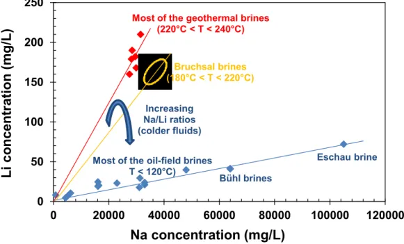
The chemical results obtained on all the fluid samples collected from the geothermal wells drilled down to the granite basement (Figure 2) indicate that these fluids are NaCl type, enriched in calcium and lithium (Figure 4) and depleted in magnesium, with a pH value around 5.0 (Dezayes et al., 2012). Their TDS values vary from 97-101 g/L (Soultz and Rittershoffen fluids) to 106-107 g/L (Landau and Insheim fluids). These small discrepancies in salinity, their different mass Cl/Br ratios (about 235-270 for Soultz and Rittershoffen fluids and 300-350 for Landau and Insheim fluids) as well as their different isotopic deuterium and 18-oxygen signatures suggest that the origin of these fluids is not exactly the same one. For example, even if all the geothermal fluids have both marine and meteoric origins, those of Soultz and Rittershoffen would have more significant contributions of meteoric freshwaters than those of Landau and Insheim (lower Cl concentrations), and would have also dissolved less evaporitic halite (lower Cl/Br ratios). Note that the Cl/Br ratios, and some concentrations of dissolved species (sulfates, for example) and isotopic values (34-sulphur of the dissolved sulfates), can also slightly vary following the depth where the water samples are collected, as this was observed and interpreted in the Soultz geothermal site (Pauwels et al. 1993; Aquilina et al., 1997; Sanjuan et al., 2010). For all these fluids, the main cation geothermometers (Na-K, Na-K-Ca, Na-K-Ca-Mg, K-Mg, Na-Li and Mg-Li) indicate estimations of temperatures for the deep reservoir ranging from 215 to 250°C, whereas the isotopic 18O
(H2O)-18O(SO4)
geothermometer gives values varying from 200 to 210°C. For the moment, the temperature measured at the bottom-hole in the site of Soultz-sous-Forêts (about 200°C) is the highest measured value. For most of the values, the temperatures given by the silica (quartz) geothermometer (160-170°C) are under-estimated because dissolved silica may precipitate during the ascent of the deep geothermal fluid to the surface and during its corresponding cooling.
The high salinities of these geothermal fluids, their similar chemical composition, their Li isotopic signatures and the geothermometer results (Figure 4) suggest that all these fluids have reacted with sedimentary rocks at temperatures close to 220-240°C. Given the location of most of the geothermal sites and these constraints, the main reservoirs could be situated further east, towards the Graben centre where the Triassic Buntsandstein sedimentary formation is deepest and hottest (Sanjuan et al., 2010). In this area, thermal gradient values ranging from 50 to 60°C/km were determined in, at least, eight deep wells (Vernoux and Lambert, 1993). According to these values, it is possible for the Triassic formation to reach temperatures close to 200-240°C (corresponding to a depth of about 4000 m). After that, the geothermal brines would migrate from the Graben centre to its external borders (Soultz, Rittershoffen, Landau, Insheim), in the granite basement, through a complex system of deep faults still poorly defined. During their migration, these geothermal fluids would be probably diluted at different but relatively small proportions by meteoric origin freshwaters.
Figure 4 - Li versus Na concentrations relative to deep geothermal and oil-field waters present in the Upper Rhine Graben.
0
50
100
150
200
250
0
20000
40000
60000
80000
100000
120000
L
i co
n
cen
tr
ati
o
n
(mg/L)
Na concentration (mg/L)
Most of the geothermal brines(220 C < T < 240 C)
Bühl brines Most of the oil-field brines
T < 120 C) Eschau brine Increasing Na/Li ratios (colder fluids) Bruchsal brines (180 C < T < 220 C)
The fluids collected from the geothermal wells Cronenbourg, Bühl (De) and Bruchsal, which come from the Triassic Buntsandstein aquifer (Figure 2), are also NaCl type waters, enriched in calcium and depleted in magnesium, with low pH values between 5 and 7 (Pauwels et al., 1993; Dezayes et al., 2012). If the Cronembourg fluid has a TDS value (103-104 g/L) comprised between those of the Soultz and Landau fluids, the TDS values for the Bühl (de) and Bruchsal (201 and 121-125 g/L, respectively) are higher. The mass Cl/Br ratios for the Bruchsal fluid (330-360) is comparable to those of the Landau and Insheim neighboring fluids whereas those of the Cronenbourg and Bühl (De) fluids are similar (about 165-170) and are the lowest measured values. This suggests that the contribution of evaporitic halite dissolution in the salinities of these two fluids is less significant than for the other fluids. Globally, we can notice that the Cl/Br ratio values are consistent with the geographical locations of the geothermal sites.
If the reservoir temperatures estimated using geothermometry for the Cronenbourg fluid (Pauwels et al., 1993) are comparable to those obtained for the geothermal fluids collected from the granite basement (Figure 4), the temperatures estimated for the Bruchsal and Bühl (De) fluids are lower (180-220°C and 110-120°C, respectively). The lower temperature estimated for the Bruchsal fluid is in agreement with the helium isotopic measurements performed in the gases associated with this fluid and that of Insheim. Indeed, the mantle helium contribution estimated using these measurements was about 1.5% for Bruchsal ([(3He/4He)/(3He/4He)
atm.] =
0.128) against 2.9% for Insheim ([(3He/4He)/(3He/4He)
atm.] = 0.252). These measurements are also consistent with the local data
obtained by Griesshaber et al. (1992) and Clauser et al. (2002), as well as with the 13-carbon isotope values (-5.2 and -4.7‰, respectively). We can notice that the geothermal sites of Bruchsal and Bühl (De), colder than those of Cronenbourg, Soultz, Rittershoffen, Landau and Insheim, are located in the eastern part of the Graben, contrary to the last sites which are located in the western part.
The chemical and isotopic results obtained for the Cronenbourg and Bruchsal fluids suggest that the pattern of water mixing and circulation assumed for the geothermal fluids present within the granite basement is probably the most relevant one. By taking into account the slight discrepancies observed between geothermal sites for the conservative chemical species and isotopes, there is no evidence of direct N-S hydraulic connections between these sites, whereas the presence of directional E-W fractures, which connect the Triassic sedimentary reservoirs of the Graben center, with temperatures ranging from 200 to 240°C, to the granite basement, is essential. From a detailed study about fluid inclusions in selected quartz samples of hydrothermal veins and fissure mineralizations in the Paleozoic basement and Permian-Mesozoic cap rocks, Behr and Gerler (1987) mentioned the presence of Na-Ca-Cl basinal sedimentary brines with low Cl/Br ratios (127), genetically related to marine evaporates, and accumulated in the Permo-Triassic sediment basins, which were heated and migrated towards the granite basement, during the main post-variscan tectonic events and the corresponding formation of extensive fault systems. During their ascent, cooling and mixing with sulfate/bicarbonate waters from higher levels caused mineralizations, particularly in the broken marginal areas of the basement uplifts.
The concentrations of conservative species such as Cl and Br, and the deuterium isotope values, obtained for the fluids of the nine wells located in the Landau oil-field, indicate that all these fluids of NaCl type and TDS values varying from 15.1 to 102 g/L (Dezayes et al., 2012) result from a mixing between a high salinity end-member (TDS > 102 g/L) and meteoric origin freshwaters. Their mass Cl/Br ratios ranging from 150 to 200 are similar to those of the Cronenbourg and Bühl (De) fluids, but much lower than that of the Landau, Insheim and Bruchsal fluids, which are the nearest geothermal sites. The deep temperatures estimated using the main geothermometers indicate values lower than 100°C (Figure 4). All these results and other geochemical data (Li concentrations and isotopic values, for example; Dezayes et al., 2012) suggest there is no evidence of direct hydraulic connections between the Tertiary aquifers (Figure 2), which supply in hot water these oil-wells, and the aquifers of the other formations (Buntsandstein, granite basement). The same comments can be also applied to the Na-Cl fluids collected from the oil-wells of Niederscheinbahrt, drilled down to Tertiary aquifers, which are the nearest fluids from the Soultz geothermal site (Figure 2) and indicate, however, very different geochemical properties (TDS values from 91 to 145 g/L, Cl/Br ratios close to 155-175, deep temperatures estimated using geothermometry close to 80°C; Dezayes et al., 2012).
The chemical and isotopic results obtained in the Na-Cl water samples collected from the Riehen geothermal well and the oil-well Eschau drilled down to Secondary formations (Figure 2), which are the more distant wells from the other geothermal sites, indicate that the compositions of these fluids are very different from those of the other ones (TDS values of 15.6 and 280 g/L, or Cl/Br mass ratios of 2550 and 410, respectively, for example), and have not common geochemical properties (Dezayes et al., 2012). The deep temperatures estimated using geothermometry are also lower than 100°C (Figure 4). These results could indicate the end of the circulation of deep geothermal fluids at temperatures ranging from 200 to 240°C, in the south of the Upper Rhine Graben, between the sites of Cronenbourg and Eschau. The Groβ-Gerau and Riedstadt geothermal sites, located slightly more at the north of the Speyer and Landau sites (Figure 2), could be the northern limit.
5. DISCUSSION
5.1 Relation fracture direction / filling
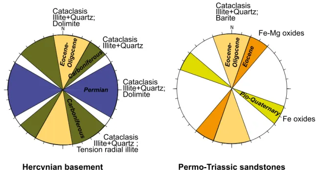
The determination of fracture infillings shows that some types of filling may be linked to the main identified fracture set directions (Figure 5).
Fracture sets NE-SW, NW-SE and NNW-SSE
In the Hercynian basement, these fracture sets are not dominant in EPS1 well within the Rhine graben. Petrological study of few samples from EPS1 containing fractures within these orientations provides evidence of polyphased fillings characterized by an early stage of shear/cataclasis with sericite mass/granite clasts cemented by illite and microquartz, and a late stage with dominant dolomite, and minor ankerite and calcite. The presence of dolomite/ankerite was already described (Dubois et al., 1996, 2000; Genter and Traineau, 1996; Ledésert et al., 2009) but their contents are probably underestimated in the bulk carbonate content. These orientations are more represented in granites outcropping on the both sides of the Rhine graben. The same type of polyphased infilling including carbonates was only identified in place in the Walhambach granite; it could be the same in the
granite crosscut by the Heidelberg borehole, but cores are not oriented. Elsewhere, these orientations are associated to cataclasis of mesothermal quartz vein (Windstein, Wintzenheim) or cataclased granite crosscut by few microquartz veinlets.
In the Permo-Triassic sandstones, these sets are dominant. Although most of fractures observed in the different sites do not present infill, Fe or Fe-Mg oxides are observed on the fracture planes at Champenay, Cleebourg and Annaberg.
Fracture set E-W
This fracture set is mainly observed in the Hercynian basement. Studied fractures belonging to this set are not frequent relative to the others. In the both granites affected by E-W fractures, this orientation is essentially associated to cataclasis (microquartz + illite) and no significant filling.
Fracture set N-S
Submeridian fracture set does not have macroscopic mineralogical fillings in the Hercynian basement outcrops. Fracture plans submitted to surficial alteration are generally very fresh and do not provide evidence of filling. In thin sections, two types of N-S fractures have been distinguished. Some major fracture corridors are associated to shearing, involving cataclasic textures and reworked quartz + illite fillings. Thin fractures preserved from direct surficial alteration do not have any shear displacement and are filled with radial illite. Alteration of granite matrix on the walls of the fracture is marked by a whole replacement of ferro-magnesian minerals and plagioclase by clay minerals with minor hematite.
In the Permo-Triassic sandstones, these N-S fractures are not numerous but at Bühl (Fr) and in EPS1 well, theses fractures represent large fault zone with shearing and cataclasic texture associated with quartz and illite and presence of barite.
Figure 5 - Synthesis of the main fracture directions with associated filling in the Hercynian granite and the Permo-Triassic sandstones.
The Hercynian basement has a long geological history marked by the Hercynian orogeny and its peneplanation with Permian N-S extension, then the opening of the Rhine graben at the Tertiary (Villemin & Bergerat, 1986; Schumacher, 2002). Triassic and Jurassic sediments were deposited during a large calm tectonic period before the Tertiary opening of the Rhine Graben.
In spite of this long history of the Rhine Graben and the reactivation of most of fractures and faults especially in the basement, we can associate the main fracture sets to the tectonic phases (Figure 5). The submeridian set is associated to the main graben phases at Eocene N-S compression and Oligocene E-W extension, but this set is certainly reactivated from the Carboniferous sudete phase for the basement. The N30°E-N50°E and N140°E-N170°E sets presented in the Hercynanian basement are linked to the Carboniferous N-S compression, probably with a reactivation in the Tertiary. The N110°E-N130°E set in the Permo-Triassic sandstones is probably linked with the last Plio-Quaternary NW-SE compression. The N60°E-N80°E and N90°E-N120°E sets are linked to the last tectonic phases of the hercynian stages during the Permian, which correspond to extension before the collapse of the range and the peneplanain.
On the granite outcrops, the submeridian fracture set is not dominant, whereas it is the main set in the cores of EPS1 well. Then, the flanks of the Rhine Graben are less affected by the brittle deformation linked to the Tertiary graben phases. Within the graben, the granite basement is largely affected by the Tertiary tectonic phases, which reactivate previous Hercynian fractures.
In the Permo-Triassic sandstones, the main fracture sets are close to the direction of large cartographic structures dependent the localization of the observation sites.
N
Permian
Hercynian basement
Permo-Triassic sandstones
Cataclasis
Illite+Quartz;
Dolimite
Eo cen e-Olig oce ne Carb onife rous NFe oxides
Fe-Mg oxides
Cataclasis
Illite+Quartz
C arb on ife rou sCataclasis
Illite+Quartz;
Dolimite
Cataclasis
Illite+Quartz ;
Tension radial illite
Eo cen e-O lig oce n e Eo cen e Pio-Q uate rnary
Cataclasis
Illite+Quartz;
Barite
5.2 Age of palaeo-circulation
The relative chronology of the fluid circulations in the fracture network affecting granites of the Hercynian basement is complex, due to the superposition of the tectonic events but also to the precipitation/dissolution processes.
Concerning carbonate deposition in NE-SW, NW-SE and NNW-SSE fractures, a current petrological study of diagenesis in EPS1 Buntsandstein sandstones close to the cover/basement interface provides evidence of late diagenetic dolomite and ankerite (Figure 6). Similar compositions of carbonates in sandstones and fracture fillings in granite strongly suggest they resulted from similar large scale fluid circulations at the cover/granite interface confirming previous works (Dubois et al., 1996, 2000), re-using Hercynian fracture framework.
Figure 6 - Ca-Fe-Mg triangular diagram showing the chemical compositions of carbonates (calcite, dolomite, ankerite, siderite) filling fractures crosscutting granite (EPS1-1418 m, 1434 m, 1648 m, 2158 m and 2161 m) and cementing sandstones (EPS1-1383 m) close to the granite interface. Analyses were performed using electron microprobe.
Up to now, dolomite and ankerite have been described simultaneously in polyphased fractures in the Hercynian basement. These textures are interpreted as alternating deposition of ankerite/dolomite/ankerite in fracture corridors and suggest pulses of fluids. However, in this study, ankerite is also observed as filling of isolated fractures, suggesting disconnected fluids. Siderite was rarely observed as fibrous siderite intercalated in yellowish illite sheets when micron-sized fissures penetrate into biotite sheet, whereas dolomite, ankerite or calcite were observed elsewhere in fractures crosscutting granite. The presence of siderite restricted to altered biotite could be interpreted to local reaction between biotite and carbonate-bearing fluids, assuming a low fluid/rock ratio, as followed:
Biotite + fluid 1 = illite + siderite + fluid 2
Such ankerite fracture fillings at 1641 meters depth in the basement cross-cut by the EPS1 well were attributed to post Oligocene up to present day fluid circulations (Dubois et al., 1996, 2000). However, similar textures and carbonates were also observed in fracture corridors affecting the Waldhambach granite on the western flank of the Rhine Graben and in fractures affecting the granite of the Heidelberg borehole on the eastern flank, demonstrate that the fluid circulations associated to these fillings were already active at the cover/granite interface before the formation of the Rhine Graben.
The formation temperatures of ankerite in the cover/granite context might be “estimated”, taking account the burial curve of sediments at the cover/basement interface. In the Bundsandstein sandstones, ankerite and dolomite are late diagenetic phases formed later than quartz aureoles and, consequently, at temperatures higher than 70-80°C. These temperatures are attained at the beginning of the graben formation, in relation with the mantle diapir.
Concerning N-S fractures in granites outcropping on the both sides of the Rhine Graben, cataclasis is the main process associated to their formation, but fillings are very rare. That strongly suggests that these structures could be considered as fractures favoring present-day recharge of fluid circulations in the Rhine Graben. Same comments could be done for studied E-W structures.
However, some N-S fissures filled with radial illite were identified in the Metzeral granite. This morphology indicates authigenic illite. Illite is not formed under surface conditions. Consequently these fillings of radial illite could precipitate from moderate-temperature fluid at depth or from ascendant moderate-moderate-temperature fluids during the mantle diapirism at the early stage of the graben phase.
5.3 Relation nature of fracture filling / actual fluid
In order to examine the water-rock interaction processes in the geothermal reservoirs of the Upper Rhine Graben, numerical runs using the most representative chemical composition of the Soultz native brine (Sanjuan et al., 2010; Sanjuan, 2014) and the EQ3NR
100 90 80 70 60 50 40 30 20 10 100 90 80 70 60 50 40 30 20 10 100 90 80 70 60 50 40 30 20 10 Ca Fe Mg EPS1-1383 m EPS1-1418m EPS1-1434m EPS1-1648m EPS1-2158 m EPS1-2161 m
geochemical code (Wolery, 1992) were performed at 200°C (temperature measured at bottom-hole) and 230°C (reservoir temperature estimated using chemical geothermometers).
The saturation indices for minerals indicate that the Soultz geothermal brine is probably close to equilibrium at 200-230°C with respect to calcite, dolomite, anhydrite, barite, fluorite, quartz, albite, feldspar, illite, pyrite and some smectites (Na, K-montmorillonites). Most of these minerals have already been observed in several hydrothermal alteration sequences of the Soultz granite (Komninou and Yerdley, 1997; Ledésert et al., 1999, for example). Globally, these calculations are concordant with the chemical and DRX mineralogical analyses of the scale-deposits collected in the surface installations, which are formed after cooling of the Soultz native geothermal brine, and are mainly constituted of barito-celestine, poly-metallic sulphides like galena, pyrite and sphalerite, carbonates, iron oxy-hydroxides, etc. (Sanjuan, 2014).
6. CONCLUSIONS
This study is an on-going work concerning the deep fluid circulation in the Rhine Graben based on a structural study linking to the analyses of their infillings and to the present-day fluid chemical.
We have shown that, in the Hercynian basement, the fracture sets are characterized by different polyphased mineralogical fillings. The analyses of the palæocirculation in the granite basement show that several stages of fracturing following by several pulses of fluid circulation have been occurred.
The Hercynian fractures, oriented NE-SW and NW-SE, show two successive stages of fillings: 1- A sheared/cataclased phase associated with illite and quartz;
2- Precipitation of dolomite in tension fractures.
The cataclasis stage associated with illite + quartz is present in the Hercynian and Permian fracture sets and also in the EPS1 well and in the Waldhambach outcrop. This shows that the fluid circulations, causing these fillings, are prior to the graben opening. The carbonate, associated to this direction, precipitated later in relation with circulation between the basement and the sedimentary cover. The temperatures of carbonate formation are around 130°C (Dubois et al., 1996). This could be the result of more recent circulations, probably during the early stage of the graben formation associated of the mantle diapirism.
A cataclasis stage is present in the N-S fractures in the basement and also in the Permo-Triassic sandstones. This fracture set is linked to the Eocene-Oligocene graben opening, with reactivation of Hercynian structures. On outcrops, this fracture set have no macroscopic mineralogical fillings, probably because fracture planes are submitted to surficial weathering alteration. However, for the granite samples, under the microscope, tension fissures are filled with radial illite, which probably recorded fluid circulation associated to the early graben opening stage before the uplifting of the shoulders. Moreover, some large N-S shear zones affect the Buntsandstein sandstones and present quartz associated to illite and barite fillings.
The fluids collected from the basement and the Buntsanstein sandstones in the deepest wells have the same origin. They have reacted with deep sedimentary rocks at about 4 or 5 km depth before migrate through the graben and probably diluted at small proportions with meteoritic freshwaters. These fluids are totally different to those from Tertiary sediments and those deeper but more in the south part of the Upper Rhine Graben. This suggests that there is no evidence of direct hydraulic connection between the Tertiary aquifers and the deepest aquifers in the Buntsandstein and the granite basement, and that the deep circulation is limited geographically between Strasbourg and the north of Speyer.
To conclude, the reactivation of old Hercynian structures, oriented NE-SW and NW-SE, in relation with the Tertiary tectonic history of the graben formation develops the fluid/basement interaction in deep temperature conditions. In the contrary, the N-S large structures favor recent circulation system and rather constitute a recharge drain.
REFERENCES
Aquilina L., Pauwels H., Genter A, and Fouillac C. Water-rock interaction processes in the Triassic sandstone and the granitic basement of the Rhine Graben: Geochemical investigation of a geothermal reservoir, Geochim. Cosmochim. Acta, 61, (1997), p. 4281-4295.
Behr, H.-J., and Gerler, J.: Inclusions of sedimentary brines in post-variscan mineralizations in the Federal Republic of Germany. A study by neutron activation analysis, Chem. Geol., 61, (1987), 65-77.
Bucher, K., and Stober, I.: Fluids in the upper continental crust, Geofluids, (2010), 1-13.
Cathelineau, M., Boiron, M-C. : Downward penetration and mixing of sedimentary brines and dilute hot water at 5 km in the granite basement at Soultz-sous-Forêts (Rhine graben, France), Comptes Rendus Géoscience, 342, (2010), p.560-565. Clauser, C., Griesshaber, E., and Neugebauer, H. J.: Decoupled thermal and mantle helium anomalies - Implications for the
transport regime in continental rift zones, J. Geophys. Res., 107, (2012), n° B11, 2269. DOI:10.1029/2001JB000675. Dezayes, C., Lerouge, C., and Sanjuan, B.: Projet TECITUR - Relation tectonique/anomalies thermiques: rôle des circulations de
fluides dans le fossé rhénan, Rapport technique d’avancement BRGM/RP-60702-FR, (2012), 138 p.
Dezayes C., Villemin T., Genter A., Traineau H. & Angelier J. : Analysis of fractures in boreholes of the Hot Dry Rock project at Soultz-sous-Forêts (Rhine graben, France). Scientific Drilling , 5, (1995), p. 31-41.
Dubois M., Ougougdal, M.A., Meere, P., Royer, J.J., Boiron, M.C. & Cathelineau, M. Temperature of Palaeo- to modern self sealing within a continental rift basin: The fluid inclusion data (Soultz-sous-Forêts, Rhine graben, France). European J. of
Mineralogy, 8, (1996), p.1065-1080.
Dubois M., Ledésert B., Potdevin J.L., Vançon S. Détermination des conditions de précipitation des carbonates dans une zone d’altération du granite de Soultz (soubassement du fossé rhénan, France). C. R. Acad. Sci. Paris; 331, (2000), 303-309. Genter A. Cuenot N., Goerke X., Melchertt B. Sanjuan B., Scheiber J.: Status od the Soultz Geothermal Project during exploitation
between 2010 and 2012. Proceeding of Stanford Geothermal Workshop, (2012).
Genter, A., Traineau, H.: Analysis of macroscopic fractures in granite in the HDR geothermal well EPS-1, Soultz-sous-Forêts, France, Journal of Volcanology and Research, 72, (1996), p.121-141.
Genter, A., Traineau, H.: Borehole EPS-1, Alsace, France: preliminary geological results from granite core analyses for Hot Dry Rock research, Scientific Drilling, 3, (1992), p.2005-214.
Griesshaber, E., O’Nions, R.K., and Oxburgh, E.R.: Helium and Carbon isotope systematics in crustal fluids from the Eifel, the Rhine Graben and Black Forest, F.R.G, Chem. Geol., 99, (1992), 213-235.
Komninou, A., and Yardley, B.W.D.: Fluid-rock interactions in the Rhine Graben - A thermodynamic model of the hydrothermal alteration observed in deep drilling, Geochim. & Cosmochim. Acta, 3, (1997), 515-531.
Ledésert B., Hébert R., Grall C., Genter A., Dezayes C., Bartier D., Gérard A.: Calcimetry as a useful tool for a better knowledge of flow pathways in the Soulz-sous-Forêts Enhanced Geothermal System. J. Vol. Geoth. Res., 181, (2009), p. 106-114.
Ledésert, B., Berger, G., Meunier, A., Genter, A., and Bouchet, A.: Diagenetic-type reactions related to hydrothermal alteration in the Soultz-sous-Forêts granite, France, Eur. J. Mineral., 11, (1999), 731-741.Loges, A., Wagner, Th., Kirnbauer, Th., Göb, S., Bau, M., Berner, Z., and Markl, G.: Source and origin of active and fossil thermal spring systems, northern Upper Rhine Graben, Germany, Applied Geochemistry, 27, (2012), 1153-1169.
Marshall, D.J.: Cathodoluminescence of geological materials. Unwin-Hyman, Boston, (1998), 146 p.
Matte P.: Tectonics and plate tectonics model for the variscan belt of Europe, Tectonophysics, 126, (1986), 329-374.
Oncken O., von Winterfeld C. and Dittmar U.: Accretion of a rifted passive margin: The Late Paleozoic Rhenohercynian fold and thrust belt (Middle European Variscides), Tectonics, vol. 18, n°1, (1999), 75-91.
Pauwels, H., Fouillac, C., Fouillac, A-M.: Chemistry and Isotopes of deep geothermal saline fluids in the Upper Rhine Graben: Origin of compounds and water-rock interactions, Geochimica et Cosmochimica Acta, 57, (1993), 2737-2749.
Richter, D. K., Götte, Th., Götze, J., and Neuser, R. D.: Progress in application of cathodoluminescence (CL) in sedimentary petrology, Mineralogy and Petrology, 79, (2003), 127–166.
Sanjuan, B.: Soultz EGS pilot plant exploitation - Phase III: Scientific program about on-site operations of geochemical monitoring and tracing (2010-2013), Final report BRGM/RP-63352-FR, (2014), 125 p.
Sanjuan, B., Millot, R., Dezayes, C., Brach, M.: Main characteristics of the deep geothermal brine (5km) at Soultz-Sous-Forêts (France) determined using geochemical and tracer data, Comptes Rendus Géosciences, 342, (2010), 546-559.
Sanjuan, B., Pinault, J.-L., Rose, P., Gérard, A., Brach, M., Braibant, G., Crouzet, C., Foucher, J.-C., Gautier, A., and Touzelet, S.: Tracer testing of the geothermal heat exchanger at Soultz-sous-Forêts (France) between 2000 and 2005, Geothermics, 35, n°5-6, (2006), 622-653.
Stober, I., and Jodocy, M.: Hydrochemical characteristics of deep seated waters in the Upper Rhine Graben. Basic information for geothermal energy, Z. Geol. Wiss, Berlin 39, 1, (2011), 39-57.
Schellschmidt, R., Hurter, S., Förster, A., and Huenges, E.: Germany, in: Hurter, S., and Haenel, R. (Eds.), Atlas of Geothermal Resources in Europe, Office for Official Publications of the European Communities, Luxemburg, (2002), 32-35, plate 20-24. Schneider C.: Les granitoïdes de la partie Nors-Est des Vosges moldanubiennes: evolutions magmatique et structural, Master’s
thesis, (1984), Université Louis Pasteur, Strasbourg, 202pp.
Schumacher M. E. : Upper Rhine Graben : role of preexisting structures during rift evolution. Tectonics, vol. 21, n°1, 1006 (2002). Vernoux, J.-F., and Lambert, M.: Aquifères profonds d’Alsace. Constitution d’une base de données à usage géothermique,
SGN/IRG ARG 93 T37 final report, (1993), 41 p.
Villemin T. and Bergerat F. : L’évolution structural du Fossé Rhénan au cours du Cénozoïque : un bilan de la déformation et des effets thermique de l’extension. Bull. Soc. Géol. France, III, 2, (1986), p. 245-255.
Villemin T. : Tectonique en extension, fracturation et subsidence : Le Fossé Rhénan et le bassin de Sarre-Nahe, PhD thesis, (1986), Paris VI, 270pp.
Wolery, Th. J.: EQ3NR, A Computer program for geochemical aqueous speciation-solubility calculations - Theoretical Manual, User’s guide, and related documentation (Version 7.0), Lawrence Livermore National Laboratory report, California, (1992), 246 p.
Ziegler P. A.: Geodynamic model for the palaeozoic crustal consolidation of western and central Europe, Tectonophysics, 126, (1986), 303-328.