CREATING COMMUNITY:
Designing for Futakotamagawa Area in Tokyo
by
Kiyoshi Kaneko
Bachelor of Architecture, Musashi Institute of TechnologyTokyo, Japan March, 1988
Submitted to the Department of Architecture
in Partial Fulfillment of the Requirements for the Degree of MASTER OF ARCHITECTURE
at the
MASSACHUSETTS INSTITUTE OF TECHNOLOGY February 1997
@ Kiyoshi Kaneko 1997. All rights reserved.
The author hereby grants to M.I.T. permission to reproduce and to distribute publicly paper and electronic copies of this thesis document in whole or in part.
Signature of the Author
Kiyoshi Kaneko Department of Architecture January 10, 1997
Certified by
Roy Strickland Associate Professor of Architecture Thesis Supervisor
Accepted by
Andrew Scott' Associate Professor of Architecture Chairperson, Departmental committee on Graduate Students
READERS
Shun Kanda
Senior Lecturer Reinhard Goethert
CREATING COMMUNITY:
Designing for Futakotamagawa Area in Tokyo
by Kiyoshi Kaneko
Submitted to the Department of Architecture on January 10, 1997 in partial fulfillment of the requirements for the degree of Master of Architecture.
ABSTRACT
This thesis develops a master plan and design guidelines for the Futakotamagawa East-region Re-development Project, a 16 hectare speculative project located on the southwest edge of Tokyo. The thesis proposes an alternative method for the design of new housing developments in Tokyo where current practice typically promotes high-rise apart-ments in an open space; this current practice ultimately results in the destruction of the sense of community.
The strategy of the thesis includes: 1) the analysis of the existing urban conditions
around the Futakotamagawa area in both local and metropolitan scale in order to anticipate development pressures, to create the project's programs, and to identify potential connec-tions between the project site and surround-ings, all of which help set the framework of a master plan; and 2) the study of representative desirable communities and housing develop-ments in Japan to extract principles for creating housing design. Finally, the thesis tests the effectiveness of a master plan and design guidelines by developing housing designs for one section of the project site.
Thesis Supervisor: Roy Strickland Title: Associate Professor of Architecture
ACKNOWLEDGMENTS My sincere gratitude Roy Strickland Shun Kanda Reinhard Goethert Akinori Kanayama Shunsuke Uchida Masamitsu Goto Masaaki Yonesu Akiko Takebayashi Masaki Furukawa Keisuke Enokido Hironori Okuno Masao Yoshitomi Stephanie Brown Fred Gutierrez Frank Hekel Daniel Sandomire Christian Klein Sam DeSollar Arlene Kisiel Paul Dreher
All of my friends at the Department of Architecture
All of my friends who have been supportive throughout my study at M.I.T.
TABLE OF CONTENTS
ABSTRACT 3
ACKNOWLEDGMENTS 5
I. INTRODUCTION 8
II. URBAN CONTEXT 13
III. CASE STUDIES 43
IV. THE MASTER PLAN 57
V. DESIGN GUIDELINES OF A BLOCK 67
VI. DESIGN GUIDELINES OF HOUSING 83
VII. DESIGN OF A BLOCK ACCORDING TO GUIDELINES 95
VIII. CONCLUSION 115
IX. LIST OF ILLUSTRATIONS, TABLES AND CREDITS 119
I. INTRODUCTION
Residential districts in metropolitan Tokyo currently suffer the effects of poor planning and urban design. Overcrowded trains, highly dense living environment, traffic congestion, and the deterioration of the sense of community typify post-war residential development in metropolitan Tokyo. Nonethe-less, post-war housing developments were considered successful in terms of their contri-bution to the growth in Japanese economy. And, we should recognize that these develop-ments responded appropriately to the demands of society - the post-war attempts to overcome the damages of the war, and the wishes for national economic development. However, these developments eventually forced people to live in unpleasant, unfavorable living conditions. The average size of housing and green space per a person was far below that of other countries. Because of the high land price, land owners tended to rebuild their
houses into high-rise apartments without any concern for their community.
Under these circumstances, the perception of the community in urban areas has been changing. People now tend to prefer living alone, away from their neighbors. Due to this interest in privacy, the composition of apartments or housing areas tends to separate communities. A typical re-development project in metropolitan Tokyo is composed of a couple of high-rise towers and vast open spaces, a form that weakens the sense of community. It also requires the demolition of old neighborhoods.
The Kansai Earthquake in January 1995 has taught us the importance of
main-taming people's perception of a community. According to newspaper reports, some areas suffered less damage from the earthquake as compared to other areas, due to the active participation of the residents in extinguishing the fire. In those areas, the residents usually participated in their neighborhood activities,
which resulted in the strong sense of commu-nity among them.
One says with nostalgia that the old down town in Tokyo was filled with warm-hearted relationships among people -a close knit community: people knew who their neighbors were and what they were doing.
Can we re-make this community today? From my point of view, it is impossible to revive the traditional style community because of
changes in economic situation. In the post-war period, people had to help each other survive because there was not enough food and supplies. This contact and the demands of survival ultimately created a tight community. Today, in the modem society where anything is easily acquired, people no longer have the necessity to live so closely. It is also true that they do not want to be involved in trouble-some relationships with their neighbors. However, at the same time we know the importance of communal life: a strong com-munity can alleviate damages from natural disasters and prevent crimes.
One of the purposes of city planning law and architectural law is to provide the citizen with a healthy environment. This thesis will approach this goal from an alternative point of view.
A. The Project
i300 km
Fig. I The metropolitan Tokyo
=
Project siteFig. 2 Picture of model for Futakotamagawa East-region Re-development Project
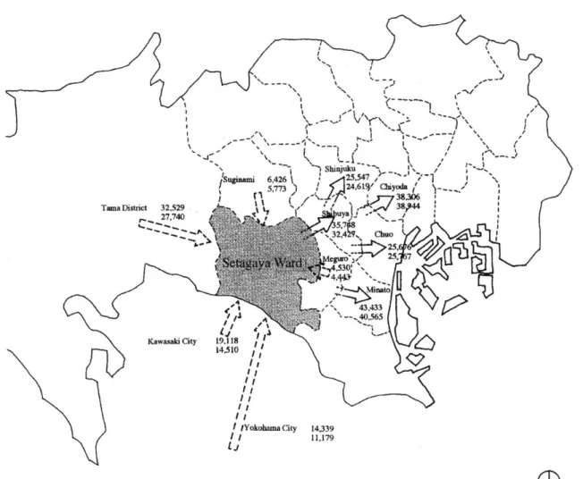
The Tamagawa region is located in Setagaya Ward of the Tokyo metropolis, one of the twenty three wards comprising the center of the metropolitan Tokyo (Fig. 1). This is the site of an ongoing project called
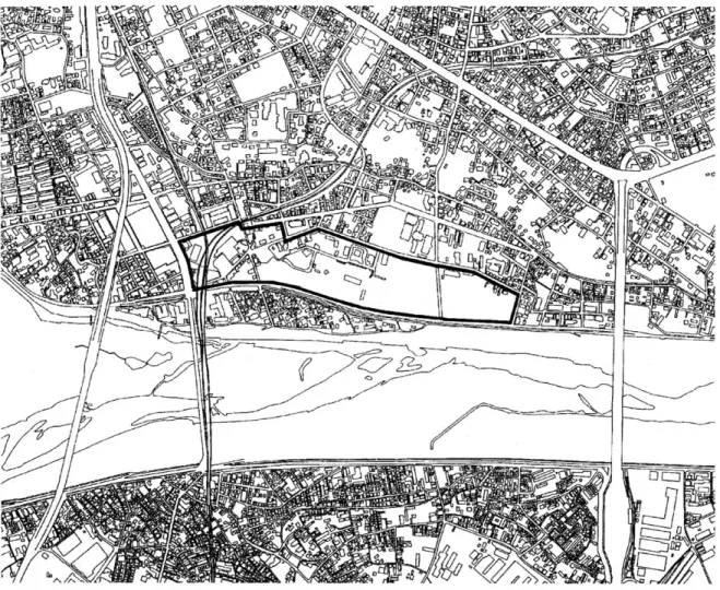
Futakotamagawa East-region Re-development Project (Fig. 2). The initial plan of the project is similar to typical re-development projects in Tokyo: two high-rise towers and open spaces, which will accommodate housing, commercial and business facilities, and a hotel. Covering an area of approximately 16 hectare, the site has been used, along with the Tama River, for recreational purposes such as theaters (demol-ished), an amusement park, tennis courts, and restaurants. Eighty land owners have orga-nized an union to promote the project (Fig. 3).
The thesis will address the following questions as a way to make an alternative plan for the Futakotamagawa East-region Re-development Project:
How does the surrounding urban context affect the characteristics of the project?
Are there architectural forms in surrounding cities which can be used for references as desirable forms for making a community?
Is it possible to determine city plan-ning and architecture based upon the forma-tion of a community?
How does the architect approach housing design in order to create a form which will enhance the generation of a community?
What are the elements which will help people sustain a sense of community?
Fig. 3 Map showing Futakotamagawa East-region Re-development Project site
0 (200m
These questions will be addressed in the conclusion of the thesis.
In the creation of workable communi-ties, the methodology explored in this thesis will be applicable to both city planning and architecture.
B. Methodology of the Thesis
This thesis proposes an approach to housing design for the Futakotamagawa East-region Re-development Project in Tokyo. It will be composed of six steps.
First, urban context will be studied to reveal the kinds of forces that have influenced the project site from the Tokyo metropolitan scale to the site scale. It will also help to predict the role of the project for the future. Due to the size of its site, it is important that the project responds to the urban context.
Second, three modem housing projects will be studied as precedents with regard to their applicability for the project. They have kept favorable community in various levels and they are located in different kinds of urban context. In addition, two traditional neighborhoods from Tokyo and Kyoto will be studied and compared to the three modem housing projects. These two neighborhoods are well known as having kept a close sense of community.
Third, the master plan will be devel-oped so as to respond to the local context as well as the district context. The master plan will divide the project site into blocks.
Fourth, one block will be selected from the site and design guidelines will be developed. These guidelines consist of two parts: design guidelines of a block and design guidelines of housing.
Fifth, design guidelines of housing will be developed, mainly exploring a relation-ship between the collective form of dwelling units and the sense of community created within the units.
Finally, The thesis will develop the
housing design for the block according to the design guidelines to test their effectiveness.
The possible extension and the generalization of the thesis will be discussed in conclusion.
Fig. 4 Thoroughfare
0
0
10kmII. URBAN CONTEXT
This chapter will analyze the forces that have influenced to the project from three urban scales: the metropolitan Tokyo scale,
Setagaya Ward scale, and the site scale. Upon considering the scale of the Futakotamagawa East-region Re-development Project located in
the southwest edge of Tokyo, it is crucial to reveal the interrelationship between the site and the broad context. The analysis will cover historical background, transportation system, thoroughfare, official zoning code, and
statistical data.
A. Urban Context of Tokyo
The Futakotamagawa area is located in the midst of a large residential district of metropolitan Tokyo. The area remained undeveloped until 1888, the year when Tokyo Urban Reconstruction Planning Law was issued and the modernization of Japan began. Since then, the role of Futakotamagawa area has changed considerably in response to the expansion of Tokyo in terms of the urban regulating areas. This section will analyze the historical background of the urbanization of Tokyo based on statistical data so as to predict the future role of the Futakotamagawa area.
U Project site
e
0 10km
Fig. 5 Railroads
The population of Tokyo is approxi-mately eleven million whereas that of the Tokyo metropolitan area, which is generally recognized as a broad area including Kanagawa, Saitama, Chiba prefecture, and Tokyo, is approximately thirty three million. With the increase in population, rail lines and main traffic arteries have expanded in a radial pattern, together with the expansion of resi-dential and business districts. The major part of the transportation system is concentrated towards the center of Tokyo and has promoted the radial growth of the city (Fig. 4). However, a number of privately owned railroad compa-nies have extended their rail lines towards the
southwest, contributing to the development of the southwestern district of Tokyo as a resi-dential district (Fig. 5). The Futakotamagawa area, located in the center of the aforemen-tioned district, has been greatly influenced by the south-westward expansion of Tokyo. The following is a chronological description of this
south-west expansion of Tokyo.
According to the major city planning laws issued by the Tokyo Government, the modern era of Tokyo can be divided into four time periods of approximately thirty to forty years: Tokyo Urban Reconstruction Planning Law of 1888, Teito Rehabilitation Plan of
under-Ueno KAsakusa honbashi 3 Project site 4 Downtown W Uptown Suburb 0 10km
takings of 1964.1 The War Damage Rehabilita-tion Plan issued in 1945 is included in the third period because it did not bring about a major impact on the city planning of Tokyo.2
The south-westward expansion of Tokyo is closely related to the interrelationship
between Yamanote, uptown, and Shitamachi,
downtown. The uptown may be defined as a residential district favored by people from upper-middle to upper classes as an ideal and sophisticated living environment. On the other hand, the downtown serves the uptown residents as a place to work, shop, and play.3 As the population of Tokyo increased, the locations of the uptown and the downtown areas have changed.
In the late nineteenth century, the
downtown was located in the area of Ueno, Asakusa, and Nihonbashi along the Sumida River (Fig. 6.1). These areas used to have the atmosphere of the traditional lifestyle of Tokyo, although it is hard to find today. The uptown was considered to be located in Hongo (Bunkyo Ward) next to the west side of the downtown and covered an area of about two kilometers from east to west and four kilome-ters from north to south. After the University of Tokyo moved to Hongo, the intellectuals preferred living in Hongo which had the implication of having social and political status. To the west of the uptown, Mejiro, Yotsuya, Akasaka, and Azabu were the subur-ban areas. However, the residential district for the upper-middle and upper classes would
Fig. 6.1 Before 1888 Transition of residential area
0
0 10km
Fig. 6.2 1888 -1923
Transition of residential area
soon spread toward those areas. Since then, the uptown expanded southwestward. In 1888, Tokyo Urban Reconstruction Planning Law was issued; its main theme was to maintain the infrastructure of the center of Tokyo and the surrounding areas.
From 1888 to 1923, Ueno and Asakusa remained as the downtown to lure people while Ginza grew into a major com-mercial district (Fig. 6.2). In 1927 the Yamate Line, a major loop railroad, was opened completely. The uptown expanded from Hongo to the west and the inside area of the Yamate Line became Yamanote, covering an area of about four kilometers from east to west and eight kilometers from north to south. This area attracted such elites as the bureaucrat and
the bourgeois to live in. The west side of the Yamate Line including Shibuya, Shinjuku, and Ikebukuro station began to develop as the new downtown district with commercial and business facilities. Construction of several private railroads were started, stretching from Shibuya, Shinjuku, and Ikebukuro station to the west. The area between the Yamate Line and Tama River emerged as a suburban area attracting people to move in. In the period between 1914 and 1926, the rate of the population increase shifted from two hundred percent to four hundred percent.4
The Kanto Earthquake of September 1, 1923 resulted in the demolition of 308,300 (62%) out of 483,000 households, and 1,334,000 injured (58%) and 58,000 dead out
Ikebukuro .*MYNOW - -_ --- '
0 10km
Fig. 6.3 1923 - 1964 Transition of residential area
of 2,309,600 residents of Tokyo.5 In December 9, 1923, the Teito Rehabilitation Plan was issued to reconstruct the city.
The southwest expansion of Tokyo was a process in which the suburban area grew into an uptown for upper-middle to upper classes, together with the downtowns to serve them. From 1923 to 1964, Ginza remained as a major commercial district with a fashionable image. At the same time, because these areas had terminal stations for commuters to change to other lines bound for the west (Fig. 6.3), Shibuya, Shinjuku, and Ikebukuro prospered as business and commercial districts. Ueno and Asakusa became traditional areas with nostalgic images reminding people of the old Tokyo dating back to the Edo era. From the
economical point of view, the Shibuya, Shinjuku, and Ikebukuro areas were the leading districts instead of Ueno and Asakusa. At this time, the west side of Tokyo up to the Tama River developed as the uptown with exclusive residential districts: Seijogakuen, Denenchohu, and Kichijoji. The classes of people who lived in the area varied from middle class to bourgeois. By this time, major railroads that contributed to the development
of the uptown opened: Tama Densha (1908), Seibu Ikebukuro line (1916), Shinjuku Line (1928), Keio Line (1914), Ikegami Line (1929), Mekama Line (1924), Odakyu Line (1928), Toyoko Line (1928), Inogashira Line (1932), Oimachi Line (1930). Although the west side from the uptown beyond the Tama
HachioupI
Fig. 6.4 1964 -present 10km
Transition of residential area
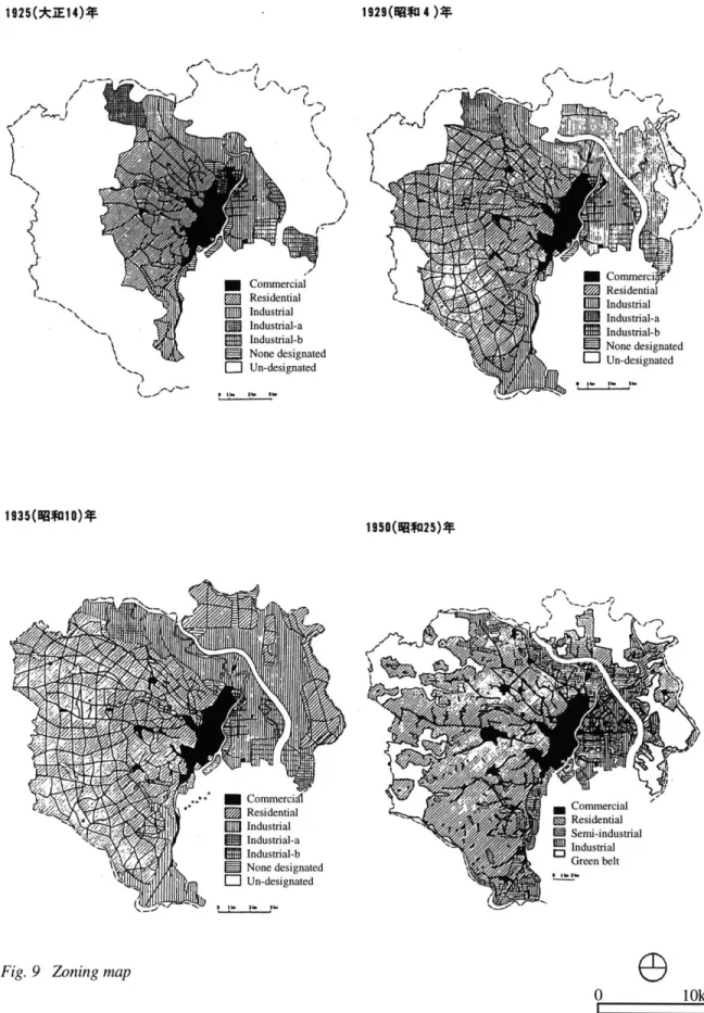
River to Kanagawa prefecture was a suburban area, the middle class moved to this area due to the high land price in the uptown of Tokyo. From 1964 to 1967, the population in the fourteen out of twenty wards at the center of Tokyo was decreasing while that of the left nine wards surrounding them was increasing by about 10%. Furthermore, in the areas surrounding the twenty-three wards, the population rate was on the increase from 30 to 40%, which indicated the typical pattern of the radiating growth (Fig. 7). Even though the population growth pattern slowed from 1980 to 1985, the surrounding areas of the center of Tokyo grew as the residential districts (Fig. 8). The zoning maps from 1925 to 1962 show that the areas including Ueno, Asakusa,
and Nihonbashi up to the Ara River were designated as commercial district, serving as a downtown (Fig. 9). The west side from the downtown was designated as a residential district while the east of that was mostly designated as an industrial district. As Tokyo expanded to the southwest with the designated residential districts, the several areas such as Ikebukuro, Shinjuku, and Shibuya were designated as commercial districts, serving the extended residential areas as the satellite downtown.
In 1964, the 18th Olympics was held in Tokyo, and prompted the maintenance of the arterial streets and the metropolitan freeway.
1964- 1967 1980- 1985
Fig. 7 Population rate Fig. 8 Population rate
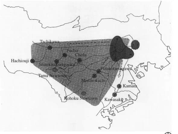
expansion of Tokyo has continued (Fig. 6.4). The fact that Tokyo City Hall was moved from Marunouchi near Ginza to Shinjuku in 1991 shows that the areas of Shibuya, Shinjuku, and Ikebukuro became leaders in terms of politics, economics, business and information. As a matter of fact, the downtown of Tokyo is now considered to be in the west side of the Yamate Line. The areas of north Kawasaki, Yokohama, and west Tokyo, which were suburbs thirty years ago, are changing into Yamanote to attract people to live in as the population increases. The construction of two large newtown projects started: Tama Newtown in 1966 and Kohoku Newtown in 1974. In 1966
0
0 20km
the Denentoshi Line that runs from Shibuya through Futakotamagawa was opened and was connected with the Chuorinkan Station in 1983.6
Thus, Yamanote tends to develop on the high land while Shitamachi tends to be on the low land. The Musashino Terrace covers an area from the west part of Tokyo to the inside of Yamate Line, where Yamanote has developed, 30m to 40m above sea level, and the east part of Tokyo is below sea level (Fig. 10). Beyond the Tama River to the south-west, Tama Terrace covers the largest section of Kawasaki city and continues to the Miura peninsula, where the new residential district as
1929(4)*
1925(*IE14)~
p.-.-
I-1950(1825)*
Fig. 9 Zoning map
e
0 10km
I 1 31, 1
Fig. 10 Topography
Yamanote is emerging. The Tama River lies between the Musashino Terrace and the Tama Terrace.
Tokyo has been expanding westward. People who live in the middle of Kanagawa prefecture commute to downtown Tokyo. Even though the major downtown moved to the west side of Yamate Line, the westward expansion is far beyond its appropriate range: 30.5% of businessmen took more than one hour to commute in 1988.7 The expansion resulted in the separation of working and living areas and caused traffic problems: people have had to commute to the center of Tokyo in extremely crowded trains; highways and main roads are constantly congested with
e
0
10kmncars. Under these circumstances, the areas along the Tama River attract a great deal of attention since these areas are located in the middle of the uptown residential district. The fact that many commercial projects were completed or are in progress along the Tama
River indicates the possibility of the new satellite downtown to emerge in the area (Fig. 11). In this urban context of Tokyo, the Futakotamagawa area will continue to be a residential area. However, it will be required to have such facilities as commercial, busi-ness, hotel, and amusement when it becomes a
satellite downtown serving the surrounding areas.
0
0 5kmn
Fig. 11 Commercial projects along the Tama River
I
Through the history of Japan, it has been difficult to execute city planning at ordinary times. Only after Japan suffered the Kanto Earthquake, a big fire, the war damage, and the national events such as the Tokyo Olympics and expositions, city planning tended to be executed.Koshizawa, Akira. Tokyo no Toshikeikaku. Tokyo, Japan: Iwanami Shoten, 1991, pp.2 3.
2 In reality, the War Damage Rehabilitation Plan
was scaled down because of the negative posture of the top-level executives of Tokyo City, the finan-cial issue, and the repeal of the city plannings. Koshizawa, Akira. Tokyo no Toshikeikaku. Tokyo, Japan: Iwanami Shoten, 1991, pp.2 3 2.
3 Masuda, Toshiji. Tokyo no shinryaku
-syutokaizou keikaku ha naniwo umunoka. Tokyo, Japan: PARCO Shuppan, 1987, pp.4 2.
4 Masuda, Toshiji. Tokyo no shinryaku
-syutokaizou keikaku ha naniwo umunoka. Tokyo, Japan: PARCO Shuppan, 1987, pp.3 8.
5 Koshizawa, Akira. Tokyo no Toshikeikaku.
Tokyo, Japan: Iwanami Shoten, 1991, pp.3 4.
6 The residential development along the
Denentoshi Line was based on the concept of Keita Goto, a founder of Tokyu Corporation, a railroad company, to make the second Setagaya ward in Kanagawa prefecture, a ideal residential district.
7 The Ministry of Construction. Nihon no
Inogashira Street Keio r-Odakyu Line Tom I-/
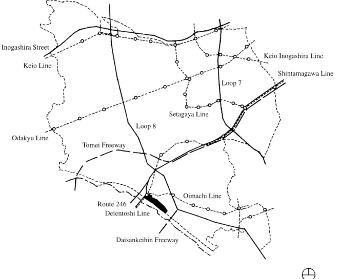
-Fig. 12 Map showing the transportation system in Setagaya Ward
B. Urban Context of Setagaya Ward
Setagaya Ward has been directly influenced by the urbanization of Tokyo -the south-westward expansion. Rail line systems, main traffic arteries, and statistical information of Setagaya Ward will aid in understanding the urban context of the Futakotamagawa East-region Re-development Project within Setagaya Ward.
The project site is located along Route 246 connecting through Shibuya, one of the major commercial and business districts, to the
Keio Inogashira Line Shintamagawa Line
0
2km
Imperial Palace (Fig. 12). To the north, Loop 8 runs close to the project site. Three railroad lines are connected at Futakotamagawa Station adjacent to the project site: Shintamagawa Line to Shibuya, Oimachi Line to Oimachi and Shinagawa, and Denentoshi Line to the residential areas of Kawasaki city and Yokohama city.
The maps of the main traffic arteries of Setagaya Ward in 1888, 1945, and 1990 show how the area of Setagaya Ward has developed (Fig. 13). Setagaya Ward used to be covered principally by open fields. The Kanto
1888 %
above 200 100 200 below 100 (pesons/hectare)
Fig. 14 Population density
1945 1990. above 300m2 250 ~ 300m2 200 ~ 250M2 below 200m2
Fig. 15 Scale of lots
0 2km
IF Fig. 13 Development of thoroughfare
o Public o Housing o Commercial
o
Industrial o Vacanto
Parko
Transportation o AgricultureFig. 16 Land use
Earthquake led to a rapid shift in population away from the center of Tokyo towards areas like Setagaya Ward. 8 In the map of 1945, the regular grid pattern of roads began to be laid from the north-east, the center of Tokyo. This indicates the surge of the west-southward expansion of Tokyo.
The population density in the project site is fifty to ninety-nine persons per hectare (Fig. 14). The closer an area is to the center of Tokyo to north-east, the more densely popu-lated it is. In response to the population density map, the closer a lot is to the center of Tokyo, the smaller its scale (Fig. 15). The subdivision of lands has occurred with the increase in population. The average of the
scale of lots in the project site area is about 300m2.
Setagaya Ward has developed into a residential district serving the downtown of Tokyo. In 1991, nearly half of Setagaya Ward land was used as housing (46%), displaying the characteristics of a residential district (Fig.
16). The ratio of land use has not changed from 1986 to 1991 except for the factor that the area of housing decreased from 49% to 46%. However, there is a tendency that Setagaya Ward is also beginning to serve as a business district. In 1990, approximately
168,000 persons among the residents in Setagaya Ward commuted to Shinjuku, Shibuya, Chiyoda, Chuo, and Minato ward,
Tama District 32,529 27,740 A" I Kawasaki City 19.118 14,510 II || II I I IYokobama City 14,339 / 11,179 L J
where commercial, business, and governmen-tal facilities are located, while the number of the commuters from Suginami and Meguro Wards, Tama District, and Kawasaki and
Yokohama cities was approximately 77,000 persons (Fig. 17). From 1985 to 1990, the ratio of the inflow to Setagaya Ward exceeded that of the outflow: the inflow increased by 20.9%, whereas the outflow increased by 10.4%. The residential area to the southwest of Tokyo has become so broad that the commercial and business districts such as Shinjuku, Shibuya,
and Ikebukuro can no longer serve the entire Tokyo metropolitan area. Although Setagaya
Ward will continue to develop as a residential district, it will also accommodate commercial and business functions to serve the areas further to the west. In addition, due to the influence of Tokyo's expansion, the surround-ing area of the Futakotamagawa East-region Re-development Project will become a densely populated area.
8 Koshizawa, Akira. Tokyo no Toshikeikaku.
Tokyo, Japan: Iwanami Shoten, 1991, Japan, pp.88.
Fig. 17 Flows of commuters
0
0
5kmn
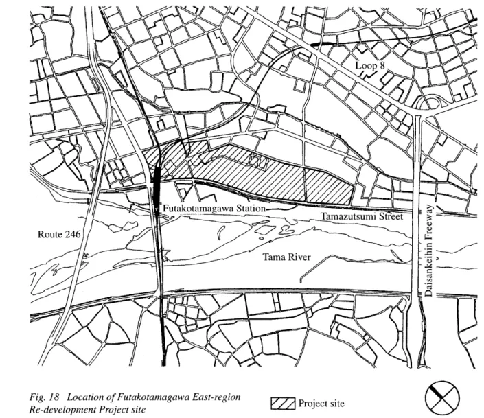
Fig. 18 Location of Futakotamagawa East-region Project site
Re-development Project site
0 300m
C. Site Analyses 1. Location (Fig. 18):
This section will analyze the sur-rounding condition of the Futakotamagawa East-region Re-development Project. This information will serve to create the master plan for the project.
The project site is located in the southwest of Setagaya Ward along the Tama River, which flows between the metropolis of Tokyo and Kanagawa prefecture. Along the Tama River, Kokubunji Cliff divides the
lower-lying part to the south from the
Musashino Terrace to the north, creating about 20 meters difference in height geographically. The project site is adjacent to the
Futakotamagawa Station, through which the Shintamagawa Line connects the center of
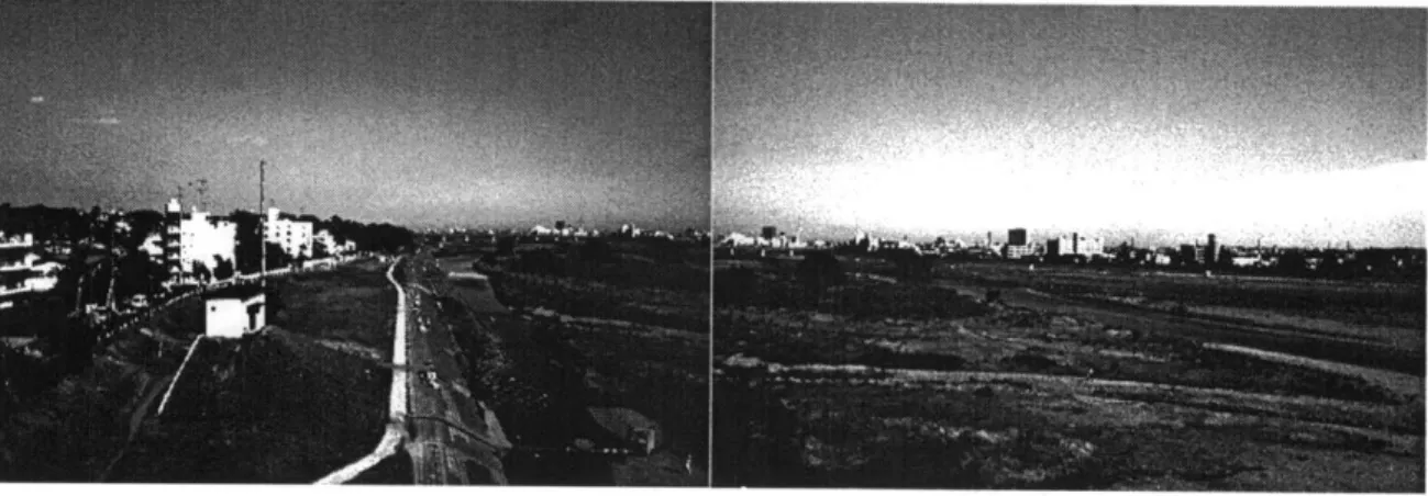
Fig. 19 Photo looking to the south-east from the platform of Futakotamagawa Station. The project site is on the left side.
Tokyo and the suburban areas. The train ride to Shibuya Station, one of the commercial districts, takes 15 minutes. To the south of the site, the river bank is formed so as to prevent the low-lying district from flooding. The site area is approximately 16 hectare, extending 800 meters from northwest to southeast with a width of 200 meters. The northwestern part of the site has been used for mainly recreational purposes such as an amusement park, tennis courts, mini patter golf course, restaurants, a theater (which is now closed), and so forth, whereas a driving school is situated on the
southeastern part. There is an ongoing project: eighty land owners including a large railroad company and a real estate company have formed an association to seek a renewal plan for the site.
Fig. 20 Figure ground
0 300m
2. Figure Ground Readings (Fig. 20, 21):
The figure-ground drawings illustrate a feature of the residential district surrounding the site: most of the area is occupied by small scale buildings. Because of the geographical difference in level created by Kokubunji Cliff, there are vacant spaces to the north-east of the site. These lots are owned mostly by institu-tions or the upper classes. The area opposite the site across from the Tama River is more densely settled than the other. Larger scale buildings are located in the area north of the Futakotamagawa Station. In most of the
Fig. 21 Reverse figure ground
0 300m
blocks, because of the Architectural Standard Laws, buildings do not form street walls and are set some distance back from streets. In the highly densely settled blocks around the Futakoshinchi Station where houses were built before the Architectural Standard Laws was issued, pathways are too narrow to go through by car. The project site and the open space along the Tama River provide the city dwellers with valuable recreational features.
Fig. 22 Street network
0 300m
3. Street Network (Fig. 22):
The street network map shows that there is no dominant pattern of street structure mainly because the development process of the residential district of Setagaya Ward was based upon the street pattern of fields. Unlike the grid pattern of Manhattan in New York, the street pattern of the surrounding area does not give a strong sense of direction to the street composition within the project site. Because of the geographical difference of ground level created by the Kokubunji Cliff, the street network is partially connected between the
k0.
Fig. 23 Photo looking at Futakotamagawa Station from the river bank
project site and Loop 8. From the project site, more tiny pathways in the blocks can be seen on the Kawasaki City side across the Tama River.
way local street. The street network around the project site must be improved because after the completion of the project, a large number of people are anticipated to move into the site. The project site is surrounded by
Route 246, Daisan-Keihin Freeway, and Loop 8, all of which serve not only the local district but the large scale area of Tokyo metropolitan area. The streets nearby the intersection between Old Route 246 and Tamazutsumi
Street are congested with traffic during weekday rush hours and especially during the weekend. Tamazutsumi Street running along the southwest edge of the project site is a
two-Fig. 24 Official zoning
0 300m
4. Official Zoning (Fig. 24):
According to the Setagaya Ward Urban Planning Zoning Map, 9 the area
surrounding the project site is mostly zoned z residential a-1, residential b-1, or residential
I districts, except for the area zoned as commercial and neighborhood commercial districts around the Futakotamagawa Station and a long strip zoned as neighborhood commercial district along the Loop 8. The project site is zoned as commercial district along the Old Route 246, neighborhood commercial district around the
Futakotamagawa Station, residential c-I district in the middle of the site, and residen-tial b-I district on the south-east part.
Each zone designated by the Urban Planning Law has restrictions by Architectural Standard Laws in terms of building type, building coverage, building volume, building height, and so forth. The following chart indicates the building coverage and the building volume restrictions for each zone on the project site:
Key Commercial Neighborhood commercial Residential a-I Residential a-2 Residential b-I Residential c-1 Residential c-2 Residential d Semi-industrial
Fig. 25 Photo looking at the project site from the river bank Zone Commercial Neighborhood Commercial Residential b-i Residential c-i Bld. Coverage 80% 80% 60% 60% Bld. Volume 500% 300% 200% 200%
9 Setagaya Ward Urban Planning Section.
Setagaya Ward Urban Planning Zoning Map (I),
(11). Tokyo, Japan: Midorikawa Chizu Insatsu, 1996.
Fig. 26 Land uses
0 300m
5. Land Uses (Fig. 26, 27):
The entire area is mainly occupied by residential buildings, which indicates the feature of the residential district in Setagaya Ward. The area for district-wide commercial activities is located to the north and the west of the Futakotamagawa Station, while to the south and east, the project site provides the district dwellers with recreational activities. Neighborhood stores and services are clus-tered along the streets around the
form-Fig. 27 Close-up of the land uses map around the project site
ing a sprawl pattern. Institutions such as universities, high schools, kindergartens, temples, and shrines are located sporadically throughout the entire area. On the Kawasaki City side, several semi-industrial facilities are located, which illustrates the characteristic of
Kawasaki City as an industrial city even though the majority of industrial facilities are located on the south part of the city along Tokyo Bay.
0
O
0 200m Key Commercial V InstitutionQ
ResidentialE2i
Industrial
Fig. 28 Building height
0
)
0 300m
6. Building Height (Fig. 28, 29):
The southwest district of Setagaya and a portion of Takatsu Ward are predominantly occupied by low-rise, one or two story build-ings, most of which are houses or apartments. The northern part of the Futakotamagawa Station and the strip area along Loop 8 are occupied by commercial buildings with building heights higher than five stories. The building heights in the area are based on the Setagaya Ward Urban Planning Zoning Map which is in accordance with the building regulations by Architectural Standard Laws.
Fig. 29 Close-up of the building height map around the project site
Since the project site is located along the Tama River, the physical structure of the project will directly influence the surrounding area. In terms of their view of the river, the residential area to the northeast of the site will be espe-cially influenced.
LIZ
0
O
0 200m
Key
7 stories and above 5-6 stories
3-4 stories 1-2 stories
Fig. 30 Open space
0 300m
7. Open Spaces (Fig. 30):
There are extensive public open spaces along the Tama River. Area A is Hyogojima Park and, because it has been kept in good condition, is a popular place to visit. The open space map shows that there are several open spaces around the project site. However, only three, B, C, and D, are open to the public while the rest of them are school grounds. In general, school grounds are not always open to the public. Area B is a part of the project site and has an amusement park, tennis courts, a mini soccer filed, and
restau-Fig. 31 Photo looking at the driving school from the river bank
rants. This area serves for people in a district-wide scale. Parcel C is a forest park and area D has a baseball field and tennis courts.
III. CASE STUDIES
To seek their applicability to the project with respect to a relation between collective form and community as well as
architectural forms, this section analyzes several precedents in Japan. Three low-rise housing projects, which have formed desirable neighborhoods, are selected from different locations. In addition, two traditional neigh-borhoods that have strong communities will be analyzed.
This project located in Shibuya, one of the commercial and business districts, consists of six phases completed from 1968 to 1992. In this case study, the first three phases will be studied. Commercial facilities occupy the first floor of the front buildings and dwelling units are on the second and third floor. The front facade is open to the public, making it easy for outsiders to wander into the site. It is difficult to actually observe the residents because there is no display of the residents' private life. Although the dwelling units are very close to the public domain, the residents seem to be detached from the public field.
1,/I
Fig. 32 Site plan Fig. 34 Dimensions
"7
(7
Fig. 33 Figure ground
A. Hillside Terrace
Fig. 40 Photo of Hillside Terrace
[I
Fig. 37 Private outdoors
Hillside Terrace Architect Location Date Lot area Ground coverage Building size (FAR) Number of units Fumihiko Maki Shibuya, Tokyo 1968-1977 7,320m2 2,681m2 (37%) 9,390m2 (128%) 32 units 0 loom Community facilities Fig. 38 Clusters
Fig. 39 Parking Fig. 41 Spatial organization
(I
Fig. 36 Access
ago
MW
mass
B. Mito Rokubanike Danchi
In this project, six dwelling units form one building with a stairway entrance to each. There are two open spaces in the site, which may help form two community groups. Most of the dwelling units face the court yards, which enables natural observation by resi-dents. According to an investigation, residents who live in dwelling units facing the court yards tend to participate in community activi-ties, while others who live in dwelling units facing the outer side tend to avoid being
involved in community activities.10 The smallest community is six dwelling units sharing a narrow stairway entrance, 1.5m wide. However, the lack of visual access to the stairway from the rooms weakens the sense of sharing a common space. Projection of residents' lives from balconies to the court yards bears lively atmosphere. No car is permitted to go through the site except in emergency.
10 Suzuki, Narifumi. Toshi-Jutaku. Tokyo, Japan: Kashima Shuppankai, January 1978, pp2 9.
Fig. 42 View
Fig. 43 Void space
rF
.... ' ....
/6
Fig. 44 Site plan
Fig. 45 Figure ground
Fig. 46 Dimensions
Fig. 48 Access
Fig. 52 Photo of Mito Rokubanike Danchi
Mito Rokubanike Danchi
Architect G
Location Date Lot area
Ground coverage Building size (FAR) Number of units
Fig. 49 Private
endai Kenchiku Kenkyujo Mito, Ibaragi 1976 7,987m2 2,718m2 (34%) 5,192m2 (65%) 90 units
0
50m Fig. 50 ClustersFig. 51 Parking Fig. 53 Spatial organization of dwelling unitsFig. 53 Spatial organization of dwelling units Fig. 51 Parking
C. Sakuradai Court Village
This housing project lies on a sloped site facing the west, which makes it possible for every dwelling unit to have clear view. There are three pathways, each 1.5 meters in width extending from the north to the south, from which residents can enter their dwelling units. Two dwelling units share one entrance and every dwelling unit has a balcony on the pathway side, which enables active communi-cation among the residents. The pathways in the middle have many view access from rooms
while the pathways on the upper side do not have enough view access. Car parking is
located along the front street utilizing the slope.
Fig. 56 Site plan
0
0
Im
Fig. 57 Figure ground
Fig. 54 View Fig. 58 Dimensions
Fig. 55 Void space Fig. 59 Site paths
---Fig. 60 Access
Fig. 64 Photo of Sakuradai Court Village
Fig. 61 Private outdoors
Sakuradai Court Village Architect
Location Date Lot area
Ground coverage Building size (FAR) Number of units Shozo Uchii Yokohama, Kanagawa 1970 3,969m2 1,818m2 (37%) 4,905m2 (81%) 40 units Fig. 62 Clusters Fig. 63 Parking 1~7
D. Roji Space 11
The historical emergence of Roji space dates back to a city of tradesmen in downtown Tokyo in the Edo period from the
17th to the 19th century. Houses with retail stores, called Machiya, were lined on the front streets and behind them houses for craftsmen and servants, called Nagaya, densely gathered with narrow paths, called Roji. These Nagaya houses were small dwelling units and did not have any private outdoor space. Hence, those craftsmen and servants had to share toilets and wells, and in Roji space, their living behavior could be seen. Although these traditional housings have decreased considerably because of Kanto Earthquake, World War II, and the current economical development of Tokyo, they still exist today in the center of Tokyo and give us the images of traditional culture. The proximity of each house helps them to keep a close sense of community. In addition,
the display of the residents' life style such as flowerpots and laundry makes outsiders feel hesitant to go into Roji space. On the other hand, there is the negative aspect that a few of families may be excluded from the community because of too much interaction between the residents.
11 Kobayashi, Hideki. Shuju no Nawabarigaku. Tokyo, Japan: Shokokusha, 1992. pp.60.
0~
P
Fig. 66 Site plan
hi
I
m
Fig. 67 Figure ground
Fig. 68 Dimensions '~'%
Fig. 69 Access
a.,vds zfoyjfo uoiloag [Z -,z
aqjvds ifofo OlOt~d OZ Ald
-uld alts L,ipu uo puodop slaqinnu osauI *
* sliun I C SliUn jo IqwflN
'9) V.U8t'IV I OBUJOA00~pufloJ9
* ZUIOSL'I
oi~jolj oi~ung
1?OI1u 10-1
U0T11OOO1
16ltUu1,J. -05I !oy *
E. Machiya 12
Nakagyo in Kyoto has kept the conditions of traditional cities. It consists of four major square blocks 500 meters wide each. Each block consists of a number of rectangular blocks (120 x 60 meters) and square blocks (120 x 120 meters). Streets dividing these block are quite public while the inside spaces within blocks are private. Each dwelling unit sits on a strip site which is approximately 5 to 10 meters wide and 30 meters deep. Normally in this Machiya style, the front part of a house is occupied by a retail store, and the back part and the second floor are used as living spaces. On the far end from the front street, there is a warehouse or dwelling units for employees or others with a narrow path called Roji. In Machiya there are three types of community relationships: Omote on the front street, Uchi within a site, and Ura on the backyard. Depending on each physical space, residents have different relationships to their neighbors. It has also been said that it is hard for outsiders to become accustomed to living in a Machiya district because of its tight community.
Fig. 72 Site plan
Fig. 73 Figure ground
f-Fi
Fig. 74 Dimensions
0 30m
12 Ueda, Atsushi. Kyo-machiya, Community Kenkyu. Tokyo, Japan: Kajima Shuppan, 1976.
pp.9 4. Fig. 75 Access
II
..
ol'
at.4,
Fig. 77 Photo of Nakagyo City
Fig. 76 Figure ground of blocks
Machiva Space -Nakagyo
Location Lot area Ground coverage Number of units Nakagyo, Kyoto 4,670m2 * 3,500m2 (75%) * 34units * * These numbers depend on reading a site plan.
* w
0 500 1000 150Cm
AM (D 90
F. Comparison of Case Studies
In order to see how dwelling units are clustered in different conditions, the table on the right shows the comparison of five case studies in terms of figure ground, lot area and ground coverage, and volume of paths. In two traditional spaces, Roji and Machiya, dwelling units are more densely clustered with smaller paths than the modem housing projects are. It is true that the cramped living condition with small communal spaces generates much interaction between residents, ultimately resulting in making the close knit community.
The column of Community Grouping indicates how many dwelling units are grouped in three scales -project, block, and unit scale. The important factor of the analysis is the number of dwelling units grouped in different scale. It varies according to the conditions of open space, access, shared spaces, and the compositions of these ele-ments. These analyses will be used as refer-ences to make the guidelines of cluster in a later chapter. Figure ground Hillside Terrace Mito Rokubanike Danchi Sakuradai
ALLA
L
AJA"A
RojiKU
a
MachiyaFig. 79 Comparison of case studies 54
Volume of paths D x H (m) Community grouping (Units) (A) (B) Lot area Ground coverage Project Block (C) Cluster
Major Minor (D) Entrances to site
(E) Units/entrance (A) 32 (B) 6-12 (C) 2-4 (D) 7 7,320m2 25 x 10 5x 10 (E) 4.6 2,681m2(37%) (A) 90 (B) 30-60 (C) 6 (D) 3 7,987m2 38 x 10 1.5 x 5 (E) 15.0 2,718m2(34%) (A) 40 (B) 10-15 (C) 2 (D) 3 3,969m2 5 x 7 3.5 x 5 (E) 13.3 1,818m2(37%) (A) 31 (B) 12-20 (C) 12-20 (D) 2 1,780m2 3 x 6 2-3 x 6 (E) 15.5 1, 148m2(64%) (A) 34
(B) 34
(C)
2~4
(D) 2 4,670m2 8 x 6 1-2 x 6 (E) 173,500m
2(75%)
550 80 10m Fig. 80 Division of the project site
IV. THE MASTER PLAN
The principle of the master plan is threefold. The first is to correspond to the urban context of Tokyo. From the study of the urban context, it is predicted that the
Futakotamagawa area will become one of the major downtown satellites to serve the further west side of the residential district in the near future. The scheme of land use is designed based on this prediction so that the project may have facilities to serve in the district scale. The second is to fit into the surrounding urban structure such as street network and land uses so that the new communities may not be isolated from the surrounding communities. The idea of making communities workable is
not only to create an ideal environment within the site but also to make a connection with the surrounding neighborhoods. The third is to make the project site serve as a connecting point between the commercial activities on the north, the residential area on the east, and the river front.
The master plan gives architects or developers the general concepts of the devel-opment for the project site.
0
100m
Fig. 81 Pedestrian circulation
A. Division of the project site (Fig. 80):
The entire project site is divided into four super blocks by major circulation streets: Super Block-A, B, C, and D. Super Block-C is also divided into three blocks: Block-Cl, C2, and C3. The size of the blocks is determined by the studies of the design guidelines, the surrounding street network, and the surround-ing block size. The premise of this division is that each block will be developed and de-signed by one architect or one developer based on the design guidelines which will be de-scribed later.
B. Pedestrian Circulation (Fig. 81):
In Super Block-A, there are two plazas on both sides of the Futakotamagawa Station and the pedestrian streets are laid out so as to correspond to the surrounding second-ary streets. The pedestrian circulation in Super Block-B, C, and D is the same as the vehicular circulation. This circulation will comprise of pedestrian oriented streets based on the design guidelines. The main concept of pedestrian circulation is to make a connection between the major commercial activities on the north from the Futakotamagawa Station and the river front.
0 100m
Fig. 82 Vehicular circulation
C. Vehicular Circulation (Fig. 82)
AC-1 The street network regarding the
C-2 C-3 Futakotamagawa are has been a major issue:
the roads around the Futakotamagawa Station
are congested with cars due to the narrow streets. The vehicular Circulation map calls for the improvement of the street network.Tamazutsumi Street will be widened to 20 meters in order to smooth the traffic. Car access is not allowed within super Block-A so as to make the public domain pedestrian around the station. There is a bus terminal on the east side of the block. Except for Super Block-A, one-way vehicular streets are laid throughout the project site. However, these inner streets will prevent cars from driving
Fig. 83 Map showing the improved street network
0 200m
through fast by their design which will be described in the design guideline.
0 0oom
Fig. 84 General land uses
D. General Land Uses (Fig. 84, 85):
A B\C C-2
C-3
Key Institutional
Residential
Residential with commercial Neighborhood commercial
District-wide commercial
Zoned as commercial, Super Block-A will accommodate department stores, business facilities, and a hotel in order to respond to the larger urban context as a downtown satellite. The areas along Tamazutsumi Street are zoned as residential with commercial on the first floor, which will lead the public from the Futakotamagawa Station to the river front. Neighborhood commercial areas are sporadi-cally located on the northeast side of the project site in order to serve the residents of the project site as well as the residents to the northeast region. Three community centers are located along the inner street in Super Block-C. Institutional areas in Super Block-D
Fig. 85 Axonometric sketch of Super Block A
surround the public open space which will help connect the project site and the river front.
0 100m
Fig. 86 Parking
E. Parking (Fig. 86):
In Super Blocks-B, C, and D, street parking is allowed on most inner streets. The concept of street parking is to generate interac-tion between the residents so as to create communal spaces along the streets. Each block has a suggested location of underground parking and an entrance to it.
Key
Street parking Underground parking
Entrance to underground parking
4
0 1 00m
Fig. 87 Open spaces
F. Open Space (Fig. 87):
Key
U
There are two large public open spaces in Super Blocks-A and D. The open space in Super Block-A is more public than that of Super Block-D. The open space map
shows the suggested location of pocket plazas which will link the Futakotamagawa Station and the river front through the commercial activities along Tamazutsumi Street.
Open space
0 100m
Fig. 88 Map showing the Block-C]
V. DESIGN GUIDELINES OF A BLOCK chapter, the design guidelines for Block C-I will be developed.
Design guidelines consist of two parts: design guidelines of a block and design guidelines of housing. The design guidelines of housing will be discussed in chapter VI. The design guidelines of a block define locations of buildings and streets, land uses, street design, and building height. The prin-ciple of the design guidelines is twofold. The first is to create an environment that generates interactions between residents through dwell-ing clusters, a community center, and street activities. The second is to correspond to the surrounding environment so as to keep the quality of the residential district. In this
7m 6m
Fig. 89 Location of buildings
A. Locations of Buildings (Fig. 89):
There are six sites where buildings can be erected from Site-I to Site-6. Building structures do not necessarily stand on the edge of each site in order to make a street wall, but can be placed within the sites. The size of six sites is designed by the studies of the design guidelines of housing, street design, and the diagram of a community center.
Fig. 90 Recommended entrance locations
B. Recommended entrance locations (Fig. 90):
Each site has one to three recom-mended entrance locations. Entrances for the residents are located along the inner streets in the block and there is no residential entrance from the surrounding streets. Therefore, the residents must enter the block to reach each dwelling unit. This organization can increase the possibility of the interactions among the residents. On the other hand, commercial entrances are located along the Tamazutsumi Street and the northwest street. This
composi-0
Z 30mI I
tion of entrances helps define the distinction between public and private domains without any gates to the block.
I
I
F~I
Up to 14 metersW
Up to 10 metersFig. 91 Building height 0 30m
C. Building height (Fig. 91):
In the circumferential areas along the surrounding streets, building height is allowed up to 10 meters, whereas in the middle it is allowed up to 14 meters. The principle of the building height is to sustain the characteristics of the Futakotamagawa area as a low-rise residential district.
Site-3
Commercial 0 Neighbohood comw
Z1
ResidentialF Community facility
Fig. 92 Ground floor uses
D. Ground Floor Uses (Fig. 92):
This section defines the ground floor uses of each site. Floor uses above the second floor are predominantly residential except for Site-3. All floors of Site-3 are for community facilities. The strip areas along Tamazutsumi Street and the northwest street with 20 meters wide are zoned as commercial so as to make a public linkage between Futakotamagawa Station and the river front, corresponding to the master plan. The parts of Site-I and Site-2 along the northeast street are zoned as
Neigh-0
ll 30m borhood commercial to serve the residents of the block as well as the surrounding northeast residential areas.Site-4
L-Q
Pocket plaza * PlaygroundFig. 93 Pocket plaza 00 30m
E. Pocket Plaza (Fig. 93):
Pocket plazas are located in Site-1, Site-5, and Site-6 along Tamazutsumi Street. Together with the commercial zone along the Tamazutsumi Street, the concept of the pocket plaza is to publicly connect Futakotamagawa Station and the river front. The playground is located next to Site-3, zoned as a community center. It is recommended that the playground be designed with the community center, which will be discussed in the next section.
L-7m
5m
Fig. 94 Inner streets
F. Inner Streets (Fig. 94, 95, 96): C2, the northeast residential area, and the west residential area.
The inner streets serve for pedestrian and vehicular circulation, community activity spaces, and parking spaces, and are designed according to the street design which will be discussed in the later section I. They are located between the sites except for the space between Site-2 and Site-3. Only this space serves for pedestrian circulation. The concept of the inner streets is to make interactions between the residents as well as to create a connection between Super B,
Block-Fig. 95 Pedestrian circulation
Street parking Site-5 Site-6 F; Underground parking H4-H Ground parking I* Pedestrian entrance
V
Vehicular entrance Fig. 97 Parking 0 30m II| G. Parking (Fig. 97):Street parking is allowed in the middle part of the inner streets and ground parking is allowed in front of Site-1. Underground parking is located underneath Site-1, Site-2, and Site-3 with an entrance located between Site-1, Site-2, and Site-3. Pedestrian entrances to the underground parking are located next to the community center. It is suggested that the number of parking spaces equal that of dwelling units in the block.
Vehicular entrance to underground parking
E
IZZ1
L~~ Pedestrian entrance to underground parking --- 1 Pedestrian entrance to underground parking StreetFig. 98 Community facility
H. Community Facility (Fig. 98):
The principle of the community center is to generate community groups beyond the cluster of dwelling units. It is suggested that the community center serve several age groups, with such facilities as a nursery, cafe, workshop room, gallery, meeting room, audio visual room, and gymnasium. The diagram of the community facility shows the relation of each function. The most important part of the diagram is the relation between nursery, playground, gallery, cafe, and the front street.
The concept of this relation is to expand the activities around the community center into the inner streets.
Green space
Parking space
Private outdoor space
Fig. 99 Elements of street design
24m
Fig. 100 Location of street
I. Street Design (Fig. 99): 1. Location of Street (Fig. 100):
The principle of the street design is to The concept of this design is that the enable the street to serves as a place where the street is mainly the pedestrian domain. The residents can communicate with each other. street, which includes roadway and sidewalk, Since the entrances to the dwelling units are can be placed within the width of 8 meters. It located in the courtyard, according to the is suggested that the roadway meanders every guideline of housing which will be discussed 24 meters so as to prevent fast traffic on the in the next chapter, the inner streets are street. The difference in the level between designed to be places to generate not just roadway and sidewalk is less than 3 centime-access, but interactions among the residents. ters. The width of roadway is 3 meters and that The street based on the street design consists of the street including sidewalk is more than 4 of roadway, sidewalk, street parking, street meters in order to keep the minimum access furniture, trees, and green space. This section for emergency cars.
defines the locations of these elements as well as that of private outdoor space facing the
street.
24m
Fig. 101 Parking space
- L~J S
T
.. reeS .
Fig. 102 Trees and green spaces
2. Parking Space (Fig. 101):
As shown above, two to three parking spaces on the street are located on the inside of the crooked street every 24 meters. Street parking is also a place to generate interactions among the residents.
3. Trees and Green Spaces (Fig. 102):
Tree are planted on both sides of the parking space to reduce the speed of cars going through. Green spaces are placed between the street and building structure.
Fig. 103 Street furniture
Private out door space
20m 20m
Fig. 104 Private outdoor spaces
4. Street Furniture (Fig. 103): 5. Private Outdoor Spaces (Fig. 104):
Two locations for the street furniture, Two private outdoor spaces face the such as benches and chairs, are placed within street within every segment of 20 meters to every segment of 12 meters. Street furniture generate interactions between people on the provides the residents with places where they street and the residents in the apartments. can communicate.
Fig. 105 Section of street showing the relation of elements -roadway, sidewalk, street parking, street