HAL Id: hal-02902671
https://hal.archives-ouvertes.fr/hal-02902671
Submitted on 30 Jul 2020
HAL is a multi-disciplinary open access
archive for the deposit and dissemination of sci-entific research documents, whether they are pub-lished or not. The documents may come from teaching and research institutions in France or abroad, or from public or private research centers.
L’archive ouverte pluridisciplinaire HAL, est destinée au dépôt et à la diffusion de documents scientifiques de niveau recherche, publiés ou non, émanant des établissements d’enseignement et de recherche français ou étrangers, des laboratoires publics ou privés.
Is high obliquity a plausible cause for Neoproterozoic
glaciations?
Yannick Donnadieu, Gilles Ramstein, Frédéric Fluteau, Jean Besse, Joseph
Meert
To cite this version:
Yannick Donnadieu, Gilles Ramstein, Frédéric Fluteau, Jean Besse, Joseph Meert. Is high obliquity a plausible cause for Neoproterozoic glaciations?. Geophysical Research Letters, American Geophysical Union, 2002, 29 (23), pp.42-1-42-4. �10.1029/2002GL015902�. �hal-02902671�
Is high obliquity a plausible cause for Neoproterozoic glaciations?
Yannick Donnadieu, and Gilles Ramstein LSCE, CE-Saclay, Gif sur Yvette, France
Frederic Fluteau and Jean Besse Universite´ Paris 7 - IPGP, Paris cedex 05, France Joseph Meert
Department of Geological Sciences, University of Florida, Gainesville, Florida, USA Received 18 July 2002; accepted 11 October 2002; published 12 December 2002.
[1] The main features of the low-latitude Neoproterozoic
glaciations remain the subject of controversial debates concerning possible triggers. Here we use an AGCM coupled with a slab ocean to test one of the earliest and simplest explanation for tropical glaciations: a higher obliquity of the Earth’s rotation axis. We show that high obliquity may result in an extensive glaciation during the Sturtian episode (750 Ma), due to the location of continental masses in the tropical areas, but cannot produce a large glaciation in the case of mid to high latitude paleogeographies such as those thought to typify the Varangian-Vendian episodes (620 – 580 Ma). INDEX TERMS: 1620 Global Change: Climate dynamics (3309); 9619 Information Related to Geologic Time: Precambrian; 5416 Planetology: Solid Surface Planets: Glaciation. Citation: Donnadieu, Y., G. Ramstein, F. Fluteau, J. Besse, and J. Meert, Is high obliquity a plausible cause for Neoproterozoic glaciations?, Geophys. Res. Lett. , 29(23), 2127, doi:10.1029/2002GL015902, 2002.
1. Introduction
[2] One of the most striking episodes in the Earth’s
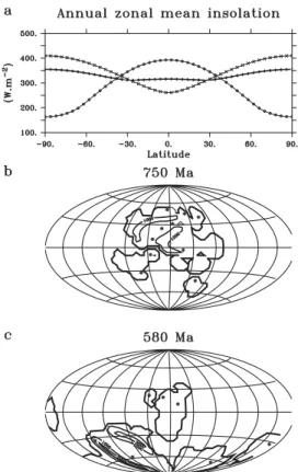
climatic history occurred during the last 250 million years of the Proterozoic era (800 – 550 Myr). At least two phases of glaciation with low latitude deposits (equatorward of 10°) have been recognized, thanks to recent paleomagnetic studies from South Australia [Sohl et al., 1999] and North-west Canada [Park, 1997]. These are referred to as the ‘‘Sturtian’’ (near 750 Ma) and the ‘‘Vendian or Varangian’’ glaciations (between 620 – 580 Ma). In 1975, G. Williams [Williams, 1975] explained these low-latitude glaciations by using an obliquity of the rotation axis of the Earth higher than 54°, a threshold value for which the equatorial latitudes receive less annual solar insolation than the poles (Figure 1a). Moreover, he collected paleoclimatic indicators (sand wedge structures) that point to a high seasonal temperature contrast close to the equator, a feature that is most readily accounted for by a high obliquity. Conversely, based on large negative carbon isotope anomalies observed in carbo-nate rocks, [Hoffman et al., 1998] gave new support to the controversial Snowball Earth theory. According to [Hoff-man et al., 1998], the carbon isotopic data indicate a collapse of oceanic photosynthesis for millions of years as a result of global glaciation until volcanogenic CO2buildup
produced a sufficiently large greenhouse effect to melt the ice. The subsequent sudden warming caused a rapid pre-cipitation of calcium carbonate, producing the cap carbonate rocks in sharp conformable contact with the underlying glacial deposits [Hoffman et al., 1998].
[3] Previous simulations with atmospheric general
circu-lation models (i.e. AGCM) showed that a near snowball state could occur with an obliquity of 70° and changes in solar insolation [Jenkins, 2000]. That study utilized an idealized rectangular supercontinent straddling the equator to mimic the Sturtian glacial interval (750 Ma). Although paleoreconstructions for that time period are extremely fluid, there is a general consensus favoring a low to mid latitude supercontinent named ‘Rodinia’ [Dalziel, 1997; Meert, 2001; Weil et al., 1998]. Other modeling studies have simulated a soft snowball event using the present-day obliquity [Hyde et al., 2000]. Those models relied on a 545 Ma reconstruction where the majority of continents extended across a wide range of latitudes [Dalziel, 1997; Meert, 2001]. We have thus performed AGCM simulations to investigate the impact of high obliquity when using a more realistic plate configuration for both time periods (Sturtian and Varangian-Vendian).
[4] Laskar et al. [Laskar et al., 1993] showed that if the
obliquity became greater than 60°, then the Earth would have experienced large, chaotic variations in obliquity between 60° and 90°. Therefore, we choose to test the high-obliquity hypothesis using the endpoint values, 60° and 90°, since all values in between are allowed and because obliquity may remain unchanged at one of these values over a 10 Ma period.
2. Model and Experiments
[5] We used the Laboratoire de Me´te´orologie Dynamique
(LMD) AGCM to perform numerical experiments. This 3D atmospheric model is extensively used to investigate future and past climates, especially during the last glacial/inter-glacial cycle [Khodri et al., 2001], but it is also used for pre-Quaternary times [Ramstein et al., 1997]. The version used (LMDz) has a horizontal resolution of 4° latitude by 5° longitude and 19 vertical levels. Since land plants had yet to evolve, the land surface has the radiative characteristics of a desert. A 50 m slab ocean that accounts for the storage of heat in the mixed layer is used. As there is absolutely no evidence for the ocean dynamics in a world with a poleward energy excess undergoing severe seasonality, we use a ‘swamp’ ocean (no heat transport). This hypothesis seems
Copyright 2002 by the American Geophysical Union. 0094-8276/02/2002GL015902
to us the most reasonable (see below for a discussion of this limitation). Sea-ice is simulated by a change in albedo from 0.1 to 0.6 and a change in heat capacity equivalent to a 10 meters sea-ice layer if the temperature is below 2°C. The LMDz AGCM has been run with four sets of boundary conditions combining two of the widely accepted paleo-geographies (Figure 1b and 1c) and two obliquity values. At 600 Ma, the solar luminosity was between 4.7 and 6.3% lower than present-day leading us to use 94% of the modern values in our experiments. The CO2 value is kept at its
modern level of 330 ppm as little is known concerning the CO2evolution of the atmosphere prior to the Phanerozoic.
3. Results
[6] The annual mean global surface temperature is very
cold for all simulations, with the lowest values for runs at 60° (from 27°C to 34°C, see Table 1). In such a cold climate, the precipitation over the continents is strongly damped by a factor of 10 in comparison with the control simulation (Table 1). The annual insolation at high latitudes is the greatest in the 90° obliquity configuration (Figure 1a) which explains the largest surface of ice-free water in the 90° runs (Figure 2) and also the greatest precipitation in these runs due to the
possibility of large evaporation from the ice-free water (Table 1). The smaller surface of sea-ice found in the 90° runs compared to the 60° runs is at the root of the difference in temperature (via the ice-albedo feedback).
[7] Given the incoming solar radiation distribution (Figure
1a), all continents located between 40°S and 40°N are covered by perennial snow in all runs (Figures 3b, 3c, and 3d) - in general agreement with the available data [Evans, 2000]. Our models indicate that snow first accumulates between 20°S and 20°N (Figure 3c) thereby enhancing low temperatures via the albedo effect over continents and favor-ing the spreadfavor-ing of sea-ice (Figure 2). The poleward Figure 1. Boundary conditions (a) Insolation forcing at the
top of the atmosphere in W m 2. The solid circles are for the present-day obliquity (23.5°) whereas the plus (+) and the crosses (x) are for values of 60° and 90°, respectively. (b) Reconstruction of the supercontinent Rodinia. The relief of 1000 meters are the relic of the ‘Greenvillian’ -aged (1300 – 900 Ma) belts. (c) Reconstruction of the 580 Ma paleogeography based on paleomagnetic data described elsewhere. East Africa orogen and Brasiliano-Trans-saharan orogen are represented. The locations of glacial deposits [Evans, 2000] are marked by stars.
Figure 2. Latitudinal evolution of the monthly-mean sea-ice margin versus model integration time for the Neoproter-ozoic simulations. (a) Results from the 60° and 90° obliquity experiments for the Sturtian period. (b) Results from the 60° and 90° obliquity experiments for the Varangian-Vendian period. Dashed black and grey lines are for a 60° and 90° obliquity respectively. The sea-ice margin represents the highest latitude with circumglobal sea-ice coverage.
Table 1. Global Mean Climate Variables
Simulation Surface Temperature (°C) Precipitation Over Land (mm/day) Snow Cover Over Land (%) CTRL 15.8 2.22 24.1 Sturt90 27.8 0.37 90.1 Sturt60 34.0 0.15 98.1 Var90 27.7 0.24 40.4 Var60 32.1 0.16 39.1
The last equilibrated five year average 16 – 20 are used in the table. The CTRL run represents the present-day climate simulated by the model. Sturt and Var are abbreviations for Sturtian and Varangian-Vendian and are used in the Figures 2, 3 and 4. The numbers following indicate the value of the obliquity used. For all runs, the precession and eccentricity are kept to their present-day values.
progression of sea-ice and snow (Figures 2 and 3) reduces the source of moisture in the equatorial band. The snow depth thus increases very slowly after a few years of simulation (Figure 3c). We notice that runs with a 90°-obliquity have the largest snow accumulation at latitudes between 20° and 40° (Figures 3b and 3d) due to their weak but relatively active hydrologic cycle compared to the 60°-obliquity runs (Table 1).
[8] For both Sturtian runs and latitudes greater than
40°N, the presence of sea-ice results in a sufficient cooling of summer temperatures (Figure 4) to allow perennial accumulation of snow regardless of the high obliquity value (Figure 3a). On the other hand, the continents poleward of 40°S are candidates for an ice-sheet inception only with a 60°-obliquity (Figure 3e and Figure 4) because of their higher latitudinal position (i.e. see the isolated
continent that goes across the latitude 60°S on the Figure 1b). This is evident by the relative importance of con-tinental snow cover between the Sturt60 and Sturt90 runs (Table 1).
[9] For the Varangian-Vendian runs, polar continents
experience a spectacular variation in temperatures, going from 70°C in August to 80°C in January (Figure 4). In fact, all continents poleward of 40°S experience summer temperatures greater than 0°C. Therefore, the balance between accumulation and melting is such that no snow accumulation occurs on more than 50% of continents (Figure 3e). Continental snow cover on our Varangian-Vendian reconstruction reveals values closer to the present-day situation than to a snowball Earth (Table 1).
4. Discussion
[10] Regardless of the paleogeography used, our GCM
experiments show that a high obliquity associated with a solar constant decrease is sufficient to produce nucleation sites for the build-up of ice-sheets between 40°N and 40°S. Moreover, the annual variation of equatorial monthly tem-peratures for the 90°-obliquity runs spans 40°C - a required value for the formation of sand-wedges [Williams, 1986]. Previously proposed climatic characteristics under high obliquity are confirmed for this latitudinal range by our study; however, the introduction of two paleogeographies and two obliquities is unique and offers new insights into possible triggers for the Neoproterozoic glacial epochs. Our experiments demonstrate that the ice-sheet latitudinal dis-tribution, previously thought to be limited to latitudes equatorward of 40° [Evans, 2000], can spread to higher latitudes depending on both the geographic configuration and the value of the Earth’s obliquity. We also note that the high obliquity allows a relatively active hydrological cycle to be maintained (other modeling studies [Chandler and Figure 3. Time evolution of the meridional monthly-mean
snow depth on land areas. (a) between 90°N and 40°N; (b) between 40°N and 20°N; (c) between 20°N and 20°S; (d) between 20°S and 40°S; and (e) between 40°S and 90°S. On the right of the picture, the percentage of continents by latitudinal band is shown using black (grey) rectangle for the Sturtian (Varangian-Vendian) paleogeography. From these curves, we see if boundary conditions are sufficient to produce perennial snow cover. For example, in (e), the Sturt90 run does not retain snow in summer, whereas the Sturt60 run shows an increase of snow depth associated with perennial snow cover beginning at year 5 and lasting until the end of the run.
Figure 4. Zonally averaged surface temperature over continents. (a) Northern hemisphere summer; (b) Northern hemisphere winter.
Sohl, 2000; Hyde et al., 2000] show a reduction in atmos-pheric water content by a factor of 100). This is due to the fact that none of our simulations reached a ‘‘hard snowball solution’’. Rather the sea-ice line oscillates seasonally (Figure 2) allowing a relatively active equatorward transport of moisture to be maintained by the atmosphere.
[11] However, the main strength of our simulations is that
they illustrate the role of the latitudinal land-sea distribution as a limiting factor in the triggering and extent of glaciations on a high obliquity Earth. During the Sturtian period, given the insolation forcing, the low to mid-latitude settings of most of the continents and the polar oceans allow the source of moisture and the cold temperatures over the superconti-nent to be maintained year round. This in turn provides optimal conditions for generating perennial snow (Figures 3 and 4 and Table 1). Conversely, because 50% of the continents are located in the 40°S – 90°S latitudinal band during the Varangian-Vendian period (Figure 3e), the pale-ogeography, combined with the high obliquity insolation forcing, does not succeed in generating perennial snow on all continents. This result rules out high obliquity as a possible trigger for the Varangian-Vendian glacial period.
[12] Our GCM results, while clear and straightforward,
are nonetheless subject to some uncertainties. (1) The exact latitudinal extent of the sea-ice and of the perennial snow cover are dependant on the absence of oceanic heat trans-port (the oceanic heat transtrans-port would slow the sea-ice migration towards the mid-latitudes). However, other mod-eling studies with two different climate models (the CCM1 with oceanic heat transport [Oglesby and Ogg, 1999] and the GENESIS with no oceanic heat transport [Jenkins, 2000]) have shown that tropical glaciations are achieved when using high obliquity values and reduced solar con-stant, reinforcing our model results. We expect that the basic nature of our results will hold even with the addition of an oceanic heat transport. In fact, regardless of the heat trans-port model used, it would not alter our conclusion that a high obliquity can not explain the extensive glaciations for the Varangian-Vendian period (to the contrary, it would reinforce our results as it may tighten the latitudinal band where glaciations occurs). (2) More importantly, it should be cautioned that some Varangian-Vendian glacial deposits lack radiometric age determinations [Evans, 2000] and there are no consensus paleogeographic reconstructions for the 580 – 700 Ma time period [Meert and Powell, 2001]. Never-theless, recent geochronologic studies [Gorokhov et al., 2001; Thompson and Bowring, 2000] help constrain the age of at least two of these glacial deposits. Gorokhov et al. [2001] estimate the age of the Vendian-Varangian glacia-tions in Norway falls between 630 – 560 Ma. Thompson and Bowring [2000] provide maximum age constraints on the Squantum tillite of the Boston Basin of 596 Ma. Thus, we feel that our Varangian-Vendian reconstruction is more applicable to our model than the 545 Ma reconstruction used in earlier climate models [Hyde et al., 2000].
[13] However, if one chooses to accept the high obliquity
as a possible trigger for the Sturtian glaciation, a new mechanism to recover from the high obliquity must be found. The only valid mechanism, climate friction [Williams et al., 1998], requires the presence of an extended ice cap on
the South polar supercontinent which is at odds with the models presented in this paper.
[14] Acknowledgments. We thank R. Trinidade and A. Nedelec for many discussions on the paleogeographic reconstructions and also the reviewers for improving the manuscript. We thank P. Broeckman for helping us in using the Ferret program for analysis and graphics in this paper. This work is supported by the French program ECLIPSE. Computing was carried out at LSCE, supported by the CEA.
References
Chandler, M. A., and L. E. Sohl, Climate forcings and the initiation of low-latitude ice sheets during the Neoproterozoic Varanger glacial interval, Journal of Geophysical Research, 105(D16), 20,737 – 20,756, 2000. Dalziel, I. W. D., Overview: Neoproterozoic-Paleozoic geography and
tec-tonics: Review, hypothesis, environmental speculation, Geological So-ciety of America Bulletin, 109, 16 – 42, 1997.
Evans, D., Stratigraphic, geochronological, and paleomagnetic constraints upon the Neoproterozoic climatic paradox, American Journal of Science, 300, 347 – 433, 2000.
Gorokhov, I. M., A. Siedlecka, D. Roberts, N. N. Melnikov, and T. L. Turchenko, Rb-Sr dating of diagenetic illite in Neoproterozoic shales, Varanger Peninsula, northern Norway, Geological Magazine, 138, 541 – 562, 2001.
Hoffman, P. F., A. J. Kaufman, G. P. Halverson, and D. P. Schrag, A Neoproterozoic Snowball Earth, Science, 281, 1342 – 1346, 1998. Hyde, W. T., T. J. Crowley, S. K. Baum, and R. W. Peltier, Neoproterozoic
‘snowball Earth’ simulations with a coupled climate/ice-sheet model, Nature, 405, 425 – 429, 2000.
Jenkins, G. S., Global climate model high-obliquity solutions to the ancient climate puzzles of the Faint-Young Sun Paradox and low-altitude Proter-ozoic Glaciation, Journal of Geophysical Research, 105(D6), 7357 – 7370, 2000.
Khodri, M., Y. Leclainche, G. Ramstein, P. Braconnot, O. Marti, and E. Cortijo, Simulating the amplification of orbital forcing by ocean feed-backs in the last glaciation, Nature, 410, 570 – 574, 2001.
Laskar, J., F. Joutel, and P. Robutel, Stabilization of the Earth’s Obliquity by the Moon, Nature, 361, 615 – 617, 1993.
Meert, J. G., Growing Gondwana and Rethinking Rodinia: A Paleomag-netic Perspective, Gondwana Research, 4, 541 – 550, 2001.
Meert, J. G., and C. M. Powell, Assembly and break-up of Rodinia: Intro-duction to the special volume, Precambrian Research, 110, 1 – 8, 2001. Oglesby, R. J., and J. G. Ogg, The effect of large fluctuations in obliquity
on climates of the late Proterozoic, Paleoclimates, 2, 293 – 316, 1999. Park, J. K., Paleomagnetic evidence for low-latitude glaciation during
de-position of the Neoproterozoic Rapitan Group, MacKenzie Mountain, N.W.T., Canada, Canadian Journal of Earth Sciences, 34, 34 – 49, 1997. Ramstein, G., F. Fluteau, J. Besse, and S. Joussaume, Effect of orogeny, plate motion and land-sea distribution on Eurasian climate over the past 30 millions years, Nature, 386, 788 – 795, 1997.
Sohl, L. E., N. Christie-Blick, and D. V. Kent, Paleomagnetic polarity reversals in Marinoan (ca. 600 Ma) glacial deposits of Australia: Implica-tions for the duration of low-latitude glaciation in Neoproterozoic time, Geological Society of America Bulletin, 111, 1120 – 1139, 1999. Thompson, M. D., and S. A. Bowring, Age of the Squantum ‘‘tillite,’’ Boston
Basin, Massachusetts: U-PB zircon constraints on terminal Neoproterozoic glaciation, American Journal of Science, 300, 630 – 655, 2000. Weil, A. B., R. Van der Voo, C. Mac Niocaill, and J. G. Meert, The
Proterozoic supercontinent Rodinia: paleomagnetically derived recon-structions for 1100 to 800 Ma, Earth and Planetary Science Letters, 154, 13 – 24, 1998.
Williams, D. M., J. F. Kasting, and L. A. Frakes, Low-latitude glaciation and rapid changes in the Earth’s obliquity explained by obliquity-oblate-ness feedback, Nature, 396, 453 – 455, 1998.
Williams, G. E., Late Precambrian glacial climate and the Earth’s obliquity, Geological Magazine, 112, 441 – 465, 1975.
Williams, G. E., Precambrian permafrost horizons as indicators of palaeo-climate, Precambrian Research, 32, 233 – 242, 1986.
Y. Donnadieu and G. Ramstein, LSCE, CE-Saclay, 91191 Gif sur Yvette, France.
F. Fluteau and J. Besse, Universite´ Paris 7 - IPGP, 2 place Jussieu, 75252 Paris cedex 05, France.
J. Meert, Department of Geological Sciences, University of Florida, Gainesville, FL, USA.