HAL Id: hal-03112019
https://hal.archives-ouvertes.fr/hal-03112019
Submitted on 22 Jan 2021HAL is a multi-disciplinary open access archive for the deposit and dissemination of sci-entific research documents, whether they are pub-lished or not. The documents may come from teaching and research institutions in France or abroad, or from public or private research centers.
L’archive ouverte pluridisciplinaire HAL, est destinée au dépôt et à la diffusion de documents scientifiques de niveau recherche, publiés ou non, émanant des établissements d’enseignement et de recherche français ou étrangers, des laboratoires publics ou privés.
Hazard assessment, risk management, and emergency
response during the 2018 sequence of earthquakes in
Lombok, West Nusa Tenggara, Indonesia
Franck Lavigne, Virgil Jean, Suwardji Suwardji, Kusnadi Kusnadi, Edonk
Kembali, Hiden Hiden, Syamsuddin Syamsuddin, Magali Reghezza-Zitt,
Bachtiar Wahyu Mutaqin, Mukhamad Malawani
To cite this version:
Franck Lavigne, Virgil Jean, Suwardji Suwardji, Kusnadi Kusnadi, Edonk Kembali, et al.. Hazard assessment, risk management, and emergency response during the 2018 sequence of earthquakes in Lombok, West Nusa Tenggara, Indonesia. 6th International Conference on Science and Technology (ICST), 2020, Mataram (virtual), Indonesia. �hal-03112019�
320
Earthquakes and tsunamis in Lombok, NTB: from hazard
assessment to crisis management
Lavigne F.1,2, Jean V.1, Suwardji3, Kusnadi4, Edong5 Hiden6, Syamsuddin6, Reghezza-Zitt M.2, Mutaqin B.8, Malawani M.N.8
1 University of Paris 1 Pantheon-Sorbonne, Laboratoire de Géographie Physique UMR 8591, France
2 Institut Universitaire de France, Paris, France
3 Universitas Mataram, Fakultas Pertanian, Mataram, Indonesia
4 Dinas Pekerjaan Umum dan Penataan Ruang Provinsi Nusa Tenggara Barat, Mataram, Indonesia
5 Badan Penanggulangan Bencana Daerah (BPBD) Provinsi Nusa Tenggara Barat, Mataram, Indonesia
6 Universitas Mataram, Fakultas MIPA, Mataram, Indonesia
7 Ecole Nationale Supérieure, Laboratoire de Géographie Physique UMR 8591, France
8 Universitas Gadjah Mada, Fakultas Geografi, Yogyakarta, Indonesia
Abstract From 29 July to 19 August 2018, the northern part of Lombok island was struck by
a sequence of deadly earthquakes, which were triggered along the Flores Thrust. In response to a collision between the Australian Plate and the Sunda Plate, the Sunda arc has begun to be pushed over the back-arc Bali Basin. The unusual succession of these large magnitude earthquakes (6 of Mw > 6 including 2 events of Mw = 6.9) surprised scientists, authorities and residents. Overall, these earthquakes killed 553 people and injured 1,416 in Lombok, killed 11 people and injured 168 in Sumbawa. More than 445 000 people were displaced during these events. Faced with these repeated events, crisis management has been difficult. Local authorities and residents felt that the central government's decisions were not in line with the actual situation in the earthquake-affected areas, preventing an effective response to the crisis. Furthermore, other natural hazards induced by earthquakes arose: more than 1,200 hikers were trapped on Mount of Rinjani, whose northern flank was hit by landslides after the 6.4 earthquake on 29 July 2018. By 5 August 2018, a tsunami warning was launched, forcing the residents to evacuate the low coastal areas. However, the evacuation process was somehow difficult for various reasons. Despite these difficulties, the population was able to recover fairly quickly from this series of disaster, thanks to the dynamism and effectiveness of local actors and Ngo’s. These tragic events have reminded us that the island of Lombok is highly exposed to geohazards such as earthquakes, volcanic eruptions and tsunamis.
Vol. 1, Juni 2020
321
1.
Introduction
The 26 December 2004 is a date corresponding to one of the most important disasters in human history. This tragedy reminded us that earthquakes remain one of the only unpredictable natural hazards, and that people living in developing countries are the most vulnerable. Due to its large surface area and the tectonic configuration of the region, Indonesia is the country in the world most exposed earthquakes and associated hazards such as tsunamis and landslides. Although Java and Sumatra are the islands most severely affected by earthquakes, the other provinces of the archipelago are not spared, such as the Lesser Sunda Islands. Thus, Lombok was struck by a sequence of deadly earthquakes between 29 July and 19 August 2018. These did not occur along the subduction zone between the Australian and Eurasian plates, located in the south of the island, but were triggered along the Flores Thrust close to the north coast.
This succession of four earthquakes of magnitude > 6 in the same sector and in such a limited time appears almost unheard of in the world. How, in such a context, could this crisis be managed? Were risk prevention measures sufficient to deal with a crisis of this magnitude? After a reminder of the chronology and magnitude of the earthquakes produced in Lombok in 2018, as well as their sources and mechanism, we will assess the effectiveness of the seismic risk prevention measures already in place before the disaster, as well as the difficulties encountered in managing such an unexpected and exceptional crisis.
2. Location and chronology of the 2018 earthquake sequence
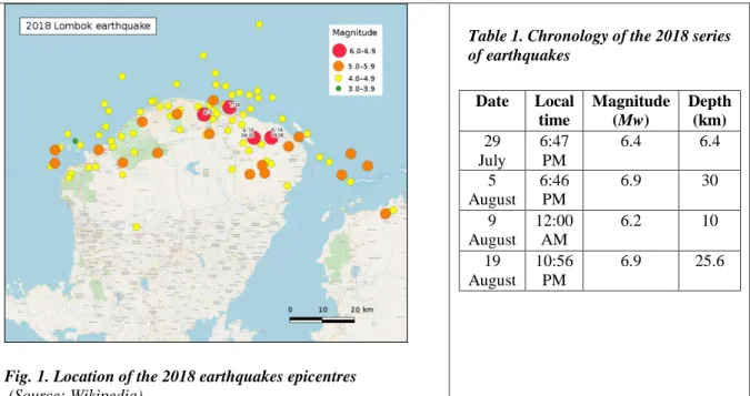
From 29 July to 19 August 2018, the northern part of Lombok island was struck by an earthquake sequence composed of ~110 M4+ events near the Flores thrust (Yang et al., 2020). The magnitude (Mw) of the four strongest events exceeded 6.2 (Fig. 1). The first one occurred on 29 July (Table 1). Its epicentre was located in Sembalun, on the eastern foot of the Rinjani volcano. A stronger event (Mw = 6.9) occurred 5 August (Table 1). Its epicentre was also located inland, near Loloan Village in North Lombok Regency (Fig. 1). The shaking of the earthquake was felt throughout the entire island, and also in Bali and Sumbawa. The fault rupture spread to the north and reached the sea, creating a small tsunami of a few tens of centimetres in Gili Islands. Ground deformation affected the half north of Lombok: uplift over 25 cm has been measured along the coastal area near Tanjung, whereas Mount Rinjani subsided up to 15 cm (Source: NASA / JPL-Caltech / Copernicus / ESA). Besides, more than 4800 earthquake-triggered landslides were reported on the slopes of the Rinjani mountain, on the river banks and unstable pumiceous cliffs like Pantai Tebing (Ferrario, 2019; Fig. 2). Although its strong magnitude (Mw 6.2), the 9 August event was reported to be an aftershock of the 5 August earthquake. On the contrary, the next one, which occurred ten days later, was as strong as the one of the 5 August (Mz 6.9), and located in the Northeast of Lombok (around Sambelia). Therefore, it was not an aftershock, and has been related attributed to another fault of the same system. This event triggered more than 9000 landslides, i.e. almost twice as much as during the 5 August event (Ferrario, 2019).
The 28 July earthquake mainly affected the hikers, who climb the Rinjani volcano in great numbers at this time of year. Twenty of them were killed, and more than 1,200 hikers -mainly foreigners- were trapped for two days on this mountain, whose northern flank was hit by landslides. Most of the people were killed during the 5 August earthquake, which was more widespread than the first one. Officials stated that at least 80% of structures in North Lombok were damaged or destroyed during this single event, which rendered difficult the evacuation of more than 400,000 people. During the 19 August earthquake, buildings already damaged by the main shock on 5 August collapsed, and more buildings were damaged. However, only 14 people were killed and 24 others injured, because most of the inhabitants have already moved from the most dangerous areas, and were more aware of the seismic hazard.
322
Fig. 1. Location of the 2018 earthquakes epicentres
(Source: Wikipedia)
Table 1. Chronology of the 2018 series of earthquakes Date Local time Magnitude (Mw) Depth (km) 29 July 6:47 PM 6.4 6.4 5 August 6:46 PM 6.9 30 9 August 12:00 AM 6.2 10 19 August 10:56 PM 6.9 25.6
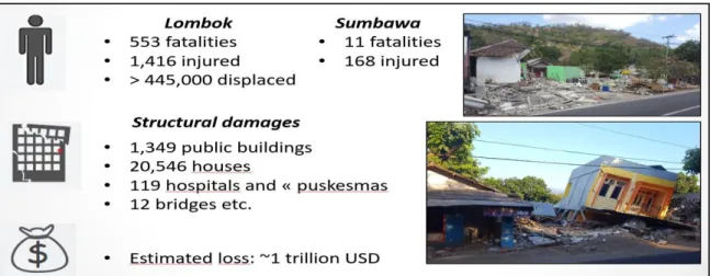
Fig. 3 display the overall damage of the series of earthquakes that shocked Lombok in 2018. All together, these events killed more than 560 people, and more than 1500 were severely injured. About half a million people in Lombok were displaced in August, mainly on the aftermath of the 5 August event. A maximum intensity of VII on the Modified Mercalli Scale was calculated for the two main earthquakes on 5 and 15 August. More than 20,000 houses were destroyed in the north part of the island (Ramdani et al., 2019).
Fig. 2. Earthquake-triggered landslides following the 5 August 2018 earthquake in North Lombok Regency.
Left: Landslide along a deep valley on the northern slope of Rinjani volcano (photo: drone view from M. Malawani, February 2019). Right: Collapse of the Pantai Tebing (photo: F. Lavigne, February 2019).
Vol. 1, Juni 2020
323
Fig. 3. Loss of lives and properties during the 2018 series of earthquakes in Lombok
(Photos: F. Lavigne, August 2018)
3. Sources and mechanism of the earthquakes
3.1. Historic Seismicity in West Nusa Tenggara (NTB)
In order to understand why a series of earthquakes shocked the northern part of Lombok, we carried out an analysis of the historic seismicity in NTB at different geographic scales. At the regional scale, Although the biggest earthquakes are located in the South, along the main subduction zone (Fig. 4A), most of the historical earthquakes are located in the North (Fig. 4B). For instance, a series of earthquakes occurred in Sumbawa the first decade of the 21st century, with similar magnitude range and orientation as the 2018 ones. At the local scale (Fig. 4C), a series of earthquakes took place between Lombok and Bali in 1979. They happened several months apart, but had a similar magnitude and orientation as the 2018 ones. The hypocentral depths were in the 25-40 km depth range.
Fig. 4. Earthquakes distribution in Lombok since 1950. A. Earthquakes > M7 B. Earthquakes > M5.5 C. Earthquakes > M4
Source: Jean, 2018, after usgs.gov
324
3.2. Rupture mechanism during the 2018 earthquake sequence
The 2018 earthquakes were triggered along the Flores thrust fault, a north vergent (i.e. dipping into the earth in a southerly direction) back thrust fault to the Sunda subduction zone fault. This thrust forms the west segment (∼450 km) of a very active, ∼E–W striking, ∼800-km-long backarc thrust along the east Sunda Arc (Yang et al., 2020). The limits of this thrust fault is, however, still under debate. Some scholars claim that it ends at a cross fault just east of Lombok (Hengresh and Whitney, 2014). However, the series of earthquakes between Lombok and Bali in 1979 suggest that the Flores thrust extends at least this far west, and probably extends from east of Timor on the east to the northern shore of Java (McCaffrey and Nabelek, 1987). This theory is supported by seismic profiles showing east-west compressional structures extending up to the northern shore of Java (Silver et al., 1986)
The 2018 earthquakes were all shallow thrust events with depth <40 km, and occurred within ∼35 km north of the Rinjani volcano. The maximum vertical deformation was ∼36 cm near the northwest margin of Lombok, caused by the 5 August Mw 6.9 event. The offshore portion of Flores thrust did not rupture during the 2018 Lombok earthquake sequence (Yang et al., 2020), which explains that no significant tsunami occurred during this event.
4. Earthquake risk management and emergency response
Following the 2004 tsunami disaster, the Indonesian government enacted a law on disaster management in 2007, and the National Agency for Disaster Management (BNPB) was established the next year. Support for Disaster Risk Management (DRM) has grown, with BNPB’s budget allocation for disaster management increasing 500 percent from 2010 to 2014. In addition, the 2015-2019 development plan has outlined the country’s disaster management policy, which aims to reduce risk, increase the resilience of national and local governments, and support communities facing disasters. In this respect, the Regional Agency for Disaster Management (BNBD) of the West Nusa Tenggara Province has developed a set of disaster risk mitigation measures against earthquakes and tsunamis. Prior to the 2018 earthquake sequence, these Disaster Risk Reduction (DRR) measures were focused on two main orientations: hazard and risk mapping, and socialization, especially in schools.
4.1. Seismic hazard assessment and risk mapping
In the frame of the Georisk-Project, a cooperation project between the Geological Agency of Indonesia and the German Federal Institute for Geosciences and Natural Resources (BGR), a hazard map of potential earthquake ground shaking (microzonation) was drawn for Mataram city (Soehaimi et al., 2013). This map was accompanied by a set of complementary maps of landuse, rock and soil classification, soft sediment thickness, predominant period, and mean amplification. The latter shows that the values of the amplification factor range from 1 in East Mataram (e.g. Cakranegara) to 2.3 in West Mataram (e.g. Ampenan), whereas Syamsuddin et al. (2014) claim that it can reach 21 with an irregular pattern. Such high values of amplification and of predominant period (up to 2.16: Hakim et al., 2019), are explained by a thick layer of soft sediment. This correlates well with the geological formation on the western part of Mataram, which is dominated by alluvium, mainly gravel, sand and clay. In addition, part of this material is composed of pumice rocks that were deposited by pyroclastic density currents (PDCs) and lahars during and after the 1257 CE eruption of Samalas volcano (Lavigne et al., 2013).
In addition to this seismic hazard map, other risk maps have been built. A “vulnerability index map” was done by the Regional Agency for Disaster Management of the West Nusa Tenggara Province (BNBD, 2015). based on four criteria: number of people, number of buildings, land use, and population vulnerability. In a similar map (Jean, 2018), the elements at risk are ranked based on SNI 1726:2012 regulation (Badan Standardisasi Nasional, 2012).
4.2. Socialisation before the 2018 disaster
Before the 2018 earthquake sequence, the BPBD has already set up a programme to raise public awareness of natural hazards, which includes seismic risk. Pamphlets on the earthquake hazard in West Nusa Tenggara were distributed to the households of Lombok. Early 2018, five hotel staffs at Senggigi
Vol. 1, Juni 2020
325 were sensitized and trained to seismic risk management. The BPBD also helps the families to prepare a survival kit, which includes the main resources in case of crisis (food, water, medicine…).
The main initiatives were oriented towards the schools, in the frame of the Safe School Initiative in Indonesia (Badan Nasional Bencana Daerah, 2013), a collaboration program between BNBD, World Bank, and other international institutions. For instance, a book chapter about the attitude to take in case of earthquake was provided by the BPBD to pupils. Evacuation drills were also organised in schools, especially in Mataram (e.g. on 8 March 2018 in the MAN 1 school: Jean, 2018), and the northern part of Lombok. These mitigation measures carried out among students have indirectly raised awareness among parents, thus helping to reduce the impacts of the 2018 earthquakes.
4.3. Emergency response during the 2018 sequence of earthquake
Having to deal with a series of strong, destructive earthquakes in a short period, the local authorities in charge of crisis management (namely, the BPBD) were confronted with a series of difficulties of functional or institutional nature.
Some difficulties were of functional order. The access in remote mountainous areas was limited due to road destruction by earthquake or landslides. By 5 August 2018, a tsunami warning was launched, forcing the residents to evacuate the low coastal areas. However, the evacuation process failed for several reasons: partial collapse of the tsunami evacuation building in Bangsal, absence of safe areas (e.g. hills) in Gili Meno and Gili Air, lack of boats in the Gili islands, where thousands of foreigners and local people waited to evacuate during the high tourist season.
Other difficulties were of institutional nature. A series of interviews conducted by Jean (2019) with local staff of BNBD and residents underlined that some of the central government's decisions were not in line with the actual situation in the earthquake-affected areas, preventing an effective response to the crisis. For instance, during the first phase of the crisis (29 July - 25 August 2018), the central government allowed foreign NGOs to intervene, e.g. OXFAM, Act for humanity, Médecins Sans Frontières, in reinforcement of national NGO like the Indonesian Red Cross (PMI). Thus 1905 volunteers from 202 different NGOs were registered in Lombok (Posko gempa Lombok, 2018). At the end of the emergency response phase, all foreign NGOs were ordered to leave Indonesian territory. This left local actors on their own, six days only after the last major earthquake.
This problem arose because de sequence of deadly earthquakes was categorized by the central government as a local natural disaster instead of a national one. The reason of this decision was twofold: (i) The declaration of a natural disaster of international scale reflects a weakness in the country's crisis management (Lipson, 2018). Indonesian President Joko Widodo wanted to show the international community that his country is capable of managing its crises internally. (ii) A significant part of Lombok's GDP comes from the tourism industry. A natural disaster considered to be of international proportions could lead to a strong media mobilization that could discourage tourists from going to Lombok... which nevertheless happened. Despite these difficulties, the population was able to recover fairly quickly from this disaster, thanks to the dynamism and effectiveness of local actors and Ngo’s.
6. Conclusion
Strong earthquakes had ever occurred in the recent past along the North Lombok district. Therefore, the earthquake sequence of 2018 was not that much surprising. The novelty came from the fact that these earthquakes were stronger than usual, and above all much deadlier because of the increase in population in this area, mainly due to the touristic development. Significant progress was achieved during the last decade in terms of disaster risk reduction in NTB, including earthquake hazard microzonation and socialization. Thus sensitization activities and evacuation drills that were organized by the PBBD in several schools soon before the 2018 earthquake sequence, have certainly played a key role in reducing the number of fatalities.
Scientists have a key role to play in improving disaster risk management in NTB. Indeed, past geological hazards, e.g. volcanic eruptions, paleoseisms and paleotsunamis are still poorly known in NTB. Therefore, the economic development and spatial planning of Lombok should be organized with caution, in respect to the natural hazards of the region. Unfortunately, the recent Mandalika megaproject, which was initiated by the Indonesian government in 2014, doesn’t meet this expectation. Indeed, it
326 plans the development of a luxurious touristic area with the construction of 26,000 hotel rooms in the south coast of Lombok, which is under the threat of tsunami hazard.
Reference
Badan Nasional Bencana Daerah, 2013. The Safe School Initiative in Indonesia, 5p.
Ferrario M. F., 2019. Landslides triggered by multiple earthquakes: insights from the 2018 Lombok (Indonesia) events. Natural Hazards: 98, 2, 575.
Hakim A. C., Pramono S., Warnana D. D., Rochman J. P. G. N., Rahmatullah F. S., 2019. Geomatics International Conference (IOP), Ser.: Earth Environ. Sci. 389 012045.
Hangesh, J. and Whitney, B., 2014. Réactivation quaternaire de la marge passive occidentale de l'Australie: création d'une nouvelle frontière de plaque? In: 5e réunion internationale INQUA sur la paléosismologie, la tectonique active et l'archéosismologie (PATA), 21-27 septembre 2014, Busan, Corée, 4 p (In French).
Jean V., 2018. Gestion du risque sismique à Mataram, Indonésie : une gestion au croisement de dynamiques de développement et de géodynamiques internes. Mémoire de master 1 DYNARISK, Université Panthéon-Sorbonne Paris 1, 112 p. (in French).
Jean V., 2019. Etude de la gestion de la crise sismique de l’été 2018 à Lombok, Nusa Tenggara Barat, Indonésie. Mémoire de master 2 DYNARISK, Université Panthéon-Sorbonne Paris 1, 138 p. (in French).
Lavigne F., Degeai J.-P., Komorowski J.-C., Guillet S., Robert V., Lahitte P., Oppenheimer C., Stoffel M., Vidal C. M., Surono, Pratomo I., Wassmer P., Hajdas I., Hadmoko D. S., Belizal E.D., 2013. Source of the Great AD 1257 Mystery Eruption Unveiled, Samalas Volcano, Rinjani Volcanic Complex, Indonesia. Proceeding of the National Academy of Sciences of the United States of America (PNAS), 110, 42, 16742-16747. DOI: 10.1073/pnas.1307520110.
Lipson D., 2018. “Lombok Quakes Should Have Been Declared a Natural Disaster, Say Critics of President”. ABC News, 27 août 2018.
McCaffrey, R. and Nabelek, J. (1987). Earthquakes, gravity, and the origin of the Bali Basin: An example of a Nascent Continental fold-and-thrust belt. Journal of Geophysical Research 92. Doi: 10.1029/JB092iB01p00441.
Posko gempa Lombok, 2018. Update penanganan bencana gempa bumi 7 SR di NTB . Rapport du 15 août 2018, Mataram, 12 p.
Ramdani F., Setiani P., Setiawati D.A., 2019. Analysis of sequence earthquake of Lombok Island, Indonesia. Progress in Disaster Science, 4, 100046.
Regional Agency for Disaster Management of the West Nusa Tenggara Province (BPBD), 2015. Peta Indeks Kerentanan Gempa Bumi Provinsi Nusa Tenggara Barat (Vulnerability Index map for earthquake, West Nusa Tenggara Province), 1p.
Silver, E.A., Breen, N.A., Prasetyo, H. & Hussong, D.M., 1986. Multibeam study of the Flores backarc thrust belt, Indonesia, J. geophys. Res., 91(B3), 3489–3500
Soehaimi A., Marjiyono J.H. Setiawan, Kamawan, Setianegara R., Sopian Y., Suwongso Sadewo M., 2013. Potential earthquake ground shaking hazard map (microzonation) of Mataram city, West Nusa tenggara Province. Center for Geological Survey (PSG), Geological Agency of Indonesia. Joint cooperation with Georisk-Project, German Federal Institute for Geosciences and Natural Resources (BGR), Bandung, 1/25,000 scale.
Syamsuddin, Kirbani S.P., Sartohadi J., Suryanto W., Aryono Adhi M., 2014. Local seismic hazard assessment of the Mataram City, Indonesia, based on a single station microtremor measurement. Proc. Of the International Conference on Mathematics, Science, and Education (ICMSE 2014). http://icmseunnes.com/download/proceeding-icmse2014.
Yang X., Singh S.C, Tripathi A., 2020. Did the Flores backarc thrust rupture offshore during the 2018 Lombok earthquake sequence in Indonesia? Geophysical Journal International, 221, 2, 758–768. (https://doi.org/10.1093/gji/ggaa018).