Civil Wars: A Dyadic Test of
Exclusion Theory
Halvard Buhaug, Lars-Erik Cederman,
and Jan Ketil Rød
Abstract Contemporary conflict research usually measures the influence of eth-nicity on conflict by capturing ethnic constellations as country-based indices, such as ethnic fractionalization or polarization+ However, such aggregated measures are likely to conceal the actual operation of actor-specific mechanisms+ In this article, there-fore, we introduce a disaggregated model that measures ethnic groups’ access to power+ We do so by disaggregating both ethnicity and conflict to the level of explicitly geo-coded center-periphery dyads+ This procedure allows us to measure the power bal-ance between politically excluded ethnic groups and dominant actors in terms of group sizes, distances between the center and the periphery, and the roughness of the lat-ter’s terrain+ We rely on geographic information systems ~GIS! to compute demo-graphic and ethno-geodemo-graphic variables+ The dyadic analysis enables us to show that exclusion of powerful ethnic minorities increases the likelihood of conflict consider-ably+ In addition, we show that the risk of conflict is positively associated with the extent of rough terrain in the peripheral group’s home region and its distance from the political center+
Recent quantitative studies of civil wars have questioned the impact of ethnic grievances on the onset of civil wars+ As with so many other findings in the political-economy literature, however, this “nonresult” is based on highly aggre-gated proxies+1 In most cases, country-level indicators, such as gross domestic
product ~GDP! per capita or ethnic fractionalization indices, do not allow us to
Earlier versions of this article were presented at the Polarization and Conflict ~PAC! conference in Nicosia, 26–29 April 2006; at the BJPS Workshop, London, 8 June 2006; at the Jan Tinbergen Peace Science Conference, Amsterdam, 26–28 June 2006; and at the Annual Convention of the American Polit-ical Science Association, Philadelphia, 30 August–3 September 2006+ We are grateful for participant comments, to Andreas Wimmer for valuable conceptual advice, and to Nils Weidmann and the other members of our coding team for their help with geo-coding the data on ethnic groups+ We also thank the editors of IO and four anonymous reviewers for useful comments+ This research was developed within the framework of GROW-Net ~Geographic Representations of War Network! research collaboration that is funded by an ECRP Grant through the European National Science Foundation ~06_ECRP_FP004!+
1+ See, for example, Fearon and Laitin 2003; and Collier and Hoeffler 2004+
International Organization 62, Summer 2008, pp+ 531–51
distinguish one explanation from another and are rarely supported by evidence at lower levels of aggregation+2Indeed, the debate over the role of ethnicity in
inter-nal conflict is far from resolved+
As a way to overcome these shortcomings in the literature, this article disaggre-gates civil wars to the level of dyads pitting states against their ethno-nationalist challengers+ This approach enables explicit empirical evaluation of actor-centered theories that expect violence to erupt where strong peripheral actors are excluded from state power+ Thus, in this study, we do not ask whether ethnic power strug-gles generate violent conflict, but how+
Focusing specifically on dyadic ethno-nationalist conflicts, our analysis enables us to measure the center-periphery power distribution in terms of demographic and geographic variables+ This is an important contribution to the literature, because unlike interstate warfare, civil wars do not lend themselves to straightforward mea-surement of power balances+ In order to compute the logistical variables and pop-ulation estimates, we make extensive and innovative use of geographic information systems ~GIS!+3
Our findings suggest that the dyadic power balance, measured as the peripheral group’s demographic size compared to the center, is indeed a strong predictor of ethno-nationalist conflict+ We also find evidence supporting the hypothesis that dyads with groups far from the capital and those located in rough terrain are more likely to experience conflict+ Standard measures of wealth—measured at the national level—appear to be at best only weakly related to ethnic conflict at the dyadic level of analysis+
Postulating Dyadic Conflict Mechanisms
We propose a group-based model of ethno-nationalist conflict that is based on a star-shaped actor constellation and on corresponding conflict mechanisms connect-ing the state’s governmental center with its periphery+4Drawing directly on
Wim-mer’s exclusion theory, we interpret ethno-nationalist conflict as the consequence of one particular path of nation-state formation+5It occurs where the elites of
nation-alizing states were not resourceful enough to include and integrate the vast major-ity of the population into the imagined communmajor-ity of the nation+ Especially in societies where no networks of civil society organizations were available, they relied on ethnic clientelism to mobilize a political following, thus excluding eth-nic others from access to power and public goods+
Whereas nation-building in strong and resourceful states with well-developed civil societies incorporated large parts of the population, sometimes with the help
2+ See Sambanis 2004; Ross 2006; and Tarrow 2007+
3+ For an earlier application of GIS in quantitative analysis of civil war, see Buhaug and Rød 2006+ 4+ Cederman and Girardin 2007+
of widespread ethnic cleansing, the situation in weaker states, mostly in the pre-viously colonized parts of the world, was quite different+ Exclusion along ethnic lines often led to political mobilization by counterelites, which denounced their underrepresentation at the center of power and demanded inclusion ~for example, the African National Congress in South Africa!, or the creation of a separate state in which their own ethnic group would represent the dominant nation ~for exam-ple, the Bengalis of former East Pakistan, now Bangladesh!+
If this exclusion perspective is correct, we would expect powerful ethnic groups excluded from power to be most likely to mobilize around an ethno-nationalist pro-gram and to initiate conflict against the government, and conversely, the govern-ment to engage in repression to curb the power of such threatening contenders+ Thus, we postulate that collective ethno-nationalist action requires both opportunities and willingness to challenge central state power+6Accordingly, civil wars occur when
peripheral contenders to the government are powerful enough to challenge the cen-ter and sufficiently motivated to do so+7In the following, we elaborate on how the
proposed mechanisms are constituted and how they can be measured+
For operational reasons, and without any claim to completeness, we focus on two crucial aspects of ethnic center-periphery relationships that we expect to sys-tematically influence both the peripheral group’s opportunities and willingness to rebel: ~1! the demographic balance between the government and the peripheral ethnic group, and ~2! the ethno-geographic constellation—especially with respect to the distance between the capital and the peripheral group—and the roughness of the terrain within the group’s settlement area+
Other things being equal, we expect that larger groups will be able to stage successful collective action thanks to their superior numbers+ While the former aspect of the hypothesis can be justified both in terms of resource mobilization, the latter one hinges on legitimacy+8 We would expect the frustrations of being
excluded and, correspondingly, motivations to engage in rebellious collective action to increase with the size of the excluded population+9This reasoning can be
sum-marized as follows:
H1: The probability of conflict increases with the relative demographic size of the excluded group.
However, the size-related hypothesis needs to be complemented, because in large states with difficult terrain, even relatively small groups may be able to wage sur-prisingly effective campaigns against powerful political centers, as the insurgen-cies in Aceh and Chechnya have demonstrated+ On average, then, we would expect
6+ Most and Starr 1989+ 7+ Gurr 2000+
8+ See DeNardo 1985; and McCarthy and Zald 1977+ 9+ Horowitz 1985+
the prospects of peripheral challenges to the central government to be the most successful in the cases where the latter’s reach is least developed+ This logic yields two straightforward hypotheses:
H2a: The probability of conflict increases with the distance between the excluded group and the capital.
H2b: The probability of conflict increases with the roughness of the terrain within the settlement area of the excluded group.
We argue that remoteness in these two senses supports excluded groups’ efforts to challenge the center’s power both in terms of opportunities and willingness to stage insurgencies+ The former argument is directly related to the geographic reach of state power, as suggested by Boulding’s notion of the “loss-of-strength gradi-ent” ~LSG!+10This notion postulates a declining function of projected power over
distance, often expressed as exponential decay+11 In addition to this materialist
mechanism, it can be expected that the cultural penetration of the center declines with distance and geographic obstacles+12
Operationalizing Ethno-Nationalist Dyads
As we argue above, the most obvious way of evaluating the exclusion perspective is to model it as a center-periphery dyad+ By measuring ethnic dyads directly and introducing an explicitly geographic dimension, the current study provides a fine-grained picture of the mechanisms driving ethno-nationalist wars+ Our goal is to study conflict between ethnically defined state authorities, that is, the “ethnic group~s! in power” and their challengers+13To succeed in our endeavor, we need
information on
1+ The identity and location of ethnic groups+ 2+ Demographic group sizes+
3+ Ethnic group~s! in power+
4+ Geo-coded data on distances and terrain+ 5+ Ethnic dyadic conflicts+
In the following, we describe our data-collection efforts before turning to a pre-sentation of the results in the subsequent section+
10+ Boulding 1962+ 11+ Buhaug 2007+ 12+ Rokkan 1999+
Geocoding Ethnic Groups
To our knowledge, there is no ready-to-use data set that systematically pins down the location of ethnic groups in a large number of comparable cases+ To create such a data set, we chose to focus on the well-known Atlas Narodov Mira ~ANM !+14
The ANM stems from a major project of charting ethnic groups undertaken by Soviet ethnographers in the early 1960s+ Their efforts bore fruit in the extensive but still untranslated atlas, containing fifty-seven ethno-geographic maps at vari-ous scales that jointly cover all inhabited parts of the world+
The ANM has several strengths: it is complete and carefully researched, it relies on a consistent classification of ethnicity, it offers a uniform group list that is valid across state borders, and it provides high-quality maps+ Among its weaknesses, it should be stressed that the ANM adopts an ethno-geographic rather than a political perspective, and is based on data available in the 1960s+ In most cases, however, ethnic settlement patterns exhibit considerable inertia, so it seems reasonable to use this data set as a starting point+
In order to make the data of the ANM available for statistical analysis, a num-ber of preparatory steps had to be conducted+ First, all of the ANM maps had to be converted to a digital format through scanning+ Then, the scanned maps were geo-referenced, meaning that they were linked to a particular coordinate system specifying locations on the earth’s surface+ Once referenced, group polygons were replicated from a computer screen displaying the geo-referenced scanned map using the mouse as digitizing cursor+ Finally, all legends and group names were translated from Russian into English and entered into the data set’s attribute table with links to the corresponding group polygons+ The resulting data set, the Geo-Referencing of Ethnic Groups ~GREG!, contains information on the geographical location of more than 1,600 ethnic groups identified in the ANM allowing com-putation of spatial measurements such as area and distance+15
Estimating Group Sizes as Share of State Populations
Having determined the geographic location of all ethnic groups, our next task was to construct a suitable measure of the power balance in the center-periphery dyads+ Because it is difficult to find direct indicators of group strength in such settings, we decided to use demographic estimates of group size+ One possible source of such information would be the ANM+ In addition to the map material, the ANM contains group-size estimates, which have often served as a basis for the calculation of ELF values+16 However, these statistics may not be ideal for
our purpose because a number of states did not exist at the time of publication,
14+ Bruk and Apenchenko 1964+ 15+ Cederman, Rød, and Weidmann 2006+ 16+ For example, Taylor and Hudson 1972+
such as the post-Soviet republics of Russia, Ukraine, Belarus, and others+ How could one derive population statistics of ethnic groups in these states based on the Soviet data?
Fortunately, GIS provides a convenient solution to this dilemma by enabling complex computational operations involving several spatially arranged data lay-ers+ Assuming the ethnic map to be constant, we used a spatial estimation method based on an intersection of territorial country masks, the group polygons, and pop-ulation density maps+ Using the boundaries in a country layer ~shapefile! repre-senting the post–Cold War period as “cookie cutters,” we singled out the group polygons ~or parts thereof ! that fell within the borders of each state+ We then inter-sected the ethnic group layer with a gridded population density layer from Colum-bia University+17This allowed us to measure the size of the population that fell
within a given ethnic group’s “state-cropped” polygon~s!+ In cases of multiple groups per polygon, we divided the population figures evenly between the groups+ By summarizing the population for all polygons belonging to an ethnic group and repeating this procedure for all groups we obtained population estimates for all groups in all countries in the ANM+ In a further step, we divided these numbers by the total population for the corresponding country, which yielded a table of the relative population share for each ethnic group+
To limit the computational effort, we decided to generate the spatially derived population shares for two years only: 1964, the ANM’s year of publication, and 1994, which captures the post–Cold War situation+ We then merged the two data sets, using the estimates from 1964 for countries that existed in that year and data for 1994 for younger states+ Finally, by way of validating the spatially computed data, we compared our group size estimates from 1964 to the pop-ulation data provided by the ANM+ This simple test indicated a high correlation, at r⫽ 0+99+ Validation of the 1994-based estimates posed more problems due to the difficulty of finding matching group data that can serve as a reference+ Nev-ertheless, a comparison with the population statistics for the corresponding eth-nic groups in Fearon’s data set yielded a reasonably high correlation coefficient ~r⫽ 0+93!+18
Identifying the Ethnic Group(s) in Power
So far, our discussion has focused on groups and polygons, but this study con-cerns dyadic dynamics+ The notion of “ethnic group~s! in power” ~EGIP! that we introduced earlier provides the crucial piece of information that makes this conceptual step possible+ In our empirical analysis, we follow Cederman and Girardin in considering a group, or a coalition of groups, to be in power if their leaders serve ~at least intermittently! in senior governmental positions, especially
17+ CIESIN 2005+ 18+ Fearon 2003+
within the cabinet+19Thus we focus on ethnic groups’ influence over the
execu-tive at the national level rather than on their legislaexecu-tive or local power+ In addi-tion to the ethnic background of senior cabinet members, specific instituaddi-tional arrangements, such as different types of power sharing and consociationalism, may also be indicators of power inclusion+ By power sharing, we mean any arrangement that divides the access to power among the groups making up the governing coalition+ Accordingly, EGIPs can consist of more than one group+ For example, we code all the four language groups of Switzerland as constituting the EGIP+
We build directly on the coding of Cederman and Girardin, who rely on Fearon’s list of ethnic groups+20Principal sources of information for identifying the EGIPs
are Gurr’s Minorities at Risk ~MAR! database, the CIA Factbook, and a new data set on ethnic affiliation of political leaders, collected by Goemans and col-leagues+21Drawing on expert input from an ongoing online survey, we made an
effort to improve the EGIP coding in several country cases+ Wherever deemed appropriate, we introduced period-dependent EGIPs to capture major shifts in the political constellation of power access ~for example, Afghanistan and Yugoslavia!+
By definition, any group not coded as an EGIP is a marginalized ethnic group ~MEG!+ We can now form center-periphery dyads as pairwise constellations of a country’s EGIP and each of its MEGs+ Given the enormous difficulty of identify-ing EGIPs in Sub-Saharan Africa, we decided to limit our empirical sample to Eurasia and North Africa, thus covering roughly half of the world’s states+
Our key independent variable, r, measures the power balance between the EGIP and the marginalized group+ It is operationalized as the periphery’s share of the dyadic population+ To illustrate, consider the Basque minority in Spain+ According to our GIS-generated estimates, the Basques comprise 5+5 percent of Spain’s pop-ulation whereas the Spaniards, the EGIP, account for 67+7 percent+ The MEG’s relative power is then calculated as r⫽ 5+50~5+5 ⫹ 67+7! ⫽ 0+075+ As one would expect, the random dyad is overwhelmingly dominated by the center ~mean r score is 0+019, meaning that the MEG comprises a mere 1+9 percent of the dyadic pop-ulation!+ Only four marginalized ethnic groups in our sample are larger than the groups in power ~r . 0+5!+22In the statistical analysis below, we apply a
logarith-mic transformation of the power balance to moderate a highly right-skewed dis-tribution of values+ In addition, it seems reasonable to assume that an increase in a group’s relative size by one percentage point should make a much larger differ-ence for small groups than for large ones+
19+ Cederman and Girardin 2007+ 20+ Fearon 2003+
21+ Goemans et al+ 2004+
22+ These are the Serbs in Bosnia and Herzegovina ~1992–95!, Arabs of Saudi Arabia in South Yemen ~1967–90!, Afghans in Afghanistan ~1992–95!, and Bengalis in Pakistan ~1947–71!+
Geocoding Distances and Terrain
It goes without saying that using raw demographic data as a proxy for relative power leaves much to be desired+ As argued here, power decays as it is projected across distance, so politically excluded minority groups may offset some of their inferiority by residing in remote provinces and enjoying the protection of rough terrain+ To account for the role of geographic mechanisms, we thus need data on the relative location of the MEGs and extent of mountainous terrain in their home regions+
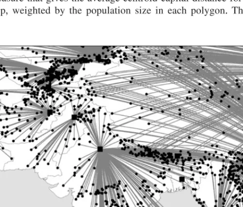
The location of the ethnic groups can be readily determined by means of geo-referenced polygons+ We used GIS to extract their precise mean center, in latitude and longitude coordinates+ Groups belonging to the EGIP are by default coded with the capital city as their location+ We then ran a script that measured the geo-desic distances from each MEG’s polygon centroid to the capital city ~see Fig-ure 1!+ For MEGs represented by two or more polygons, we generated a weighted distance measure that gives the average centroid-capital distance for all locations of the group, weighted by the population size in each polygon+ The population
weighting was necessary to prevent a distortion of distances due to small clusters far away from the group’s core settlement area+ To reduce outlier influence and to account for an expected declining effect of distance with higher values, we took the natural logarithm of the distance variable+
The second geographic proxy, which measures the extent of mountainous ter-rain, was computed in a manner similar to that of group populations+ By intersect-ing gridded mountain data with the boundaries of the ethnic groups, we were able to calculate the share of the two-dimensional area of each polygon covered by mountains+23For groups represented by multiple polygons, we weighted the
aver-age terrain values by the area of each polygon+ The area-weighted mountain vari-able takes on values between zero ~for groups in the plains! and one ~for groups settled entirely in the mountains!+
Determining the Onset of Dyadic Ethnic Conflict
The final step of data generation concerns the dependent variable, namely the out-break of dyadic ethnic conflict+ We relied on the Armed Conflicts Dataset of the Uppsala Conflict Data Collection ~UCDP! and the Peace Research Institute Oslo ~PRIO!,24 henceforth ACD,25 which is arguably the most established
country-level data set on armed conflict+ It applies a comparably low minimum casualty threshold of just twenty-five annual battle-related deaths and allows for and dis-tinguishes between multiple simultaneous conflicts within single countries+
Our operational definition of ethnic conflict is similar to that used by Fearon and Laitin,26which focuses on all conflicts in which the parties are organized
pri-marily along ethnic lines+ We make no attempt to uncover whether the contested issues are truly linked to ethnicity+ In order to separate out the ethnic rebellions from the total sample of intrastate conflicts in the ACD, we first identified those conflicts coded by other data sets as ethnic and dropped the ideological ones+27
For the remaining conflicts, we conferred relevant sources28 on a case-by-case
basis to determine whether mobilization was based on ethnic affiliation+ Finally, we identified the MEG~s! that were involved in each ethnic conflict+29 In cases
23+ Mountain data obtained from UNEP-WCMC 2002+ 24+ UCDP0PRIO Armed Conflicts Dataset v+ 4-2006+ 25+ Gleditsch et al+ 2002+
26+ Fearon and Laitin 2003+
27+ Some conflicts identified as ethnic wars by other data sources are excluded from our sample+ In most cases this is due to lack of differentiation between the warring parties in the ANM list, though there are also discrepancies in the way some conflicts are coded in various data sets+
28+ UCDP database; Keesing’s Online; Wikipedia+org; Globalsecurity+org; and the MAR project+ 29+ Incidentally, our candidate list also includes three cases of ethnic conflict within multiple-group EGIPs: Ukrainians versus the USSR ~outbreak 1946!, Assamese vs+ India ~1990, 1994!, and Panjabis versus India ~1983!+ Since these cases represent center-center rather than center-periphery dyads, they were automatically dropped from the analysis+ Nevertheless, elite infighting is an interesting form of ethnic conflict that can also be studied with disaggregated methods+
where more than one group challenged the capital at the same time, an onset of conflict was recorded in each of the corresponding dyads+ Ongoing years of con-flict are coded as missing+ In case of a lull in the fighting or a peace agreement that lasts for at least two consecutive calendar years, the next observation of con-flict in the dyad is coded as a new onset+
To facilitate comparison with country-level studies, we also generated an aggre-gated version of the dependent variable+ Here, country-years in which there are one or more onset~s! of dyadic conflict are coded as “1” while observations with-out onset ~including ongoing years of conflict! are coded “0+” In all, the dyadic data set contains 110 onsets of ethnic conflict among the roughly 35,000 valid dyad-years ~1946–2005! while the monadic data set includes fifty-five onsets in 3,463 country-years+
In addition to our key dyadic variables as described in the sections above, the statistical analysis includes a number of country-level controls+ These include Fearon and Laitin’s comprehensive selection of explanatory variables ~GDP per capita, log of population, log of mountainous terrain, noncontiguous territory, oil exports, new state, instability, democracy score, and ethnic and religious fractionalization!, Gleditsch’s logged GDP per capita,30Cederman and Girardin’s ethnic exclusion
index ~N*
!,31a variable measuring annual calendar time, and controls for duration
dependence+ All reported models are estimated by robust logit regression, cluster-ing the standard errors on the countries in the dyadic analysis+
Analyzing Country-Level Effects
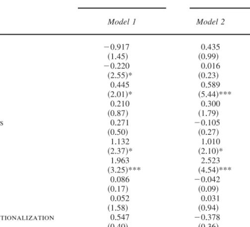
We start by testing models of ethnic conflict at the country level+ As our reference point, we apply Fearon and Laitin’s insurgency model to our restricted sample of Eurasia and North Africa+ Model 1 in Table 1 presents the findings of this repli-cation analysis, with Fearon and Laitin’s coding of “ethnic war” regressed on their standard set of independent variables+ In order to exclude countries not at risk of ethnic conflict, Model 1 is limited to country years with at least a 5 percent ethnic minority+32
As expected, this regression produces similar results to Fearon and Laitin’s global model+ Even though the replicated estimates are slightly weaker due to the reduced sample size, the variables that are significant in their model also perform well in our replication+ The overall correspondence to the original findings gives little rea-son to suspect substantial systematic bias in the reduced spatial domain of this study+
30+ Gleditsch 2002+
31+ Cederman and Girardin 2007+ 32+ See Fearon and Laitin 2003, 84+
Our next step is to replace Fearon and Laitin’s ethnic wars with our country-level measure of ethnic conflict ~and an accompanying “prior war” dummy!, derived from the ACD ~see Model 2!+ Given the latter data set’s more comprehensive def-inition of conflict, which captures multiple onsets per country and numerous spo-radic episodes of violence, it is not surprising that Model 2 provides somewhat different results+ Most strikingly, the more inclusive dependent variable com-pletely obliterates the effect of GDP per capita+ While wealth is often widely acclaimed as an effective insurance against civil war, it does not seem to be a guarantee against less severe ethnic unrest in our sample+
A second noteworthy deviation from Model 1 is that the population estimate has increased considerably and the z score has almost tripled+ This is consistent
TABLE 1. Logit analysis of onset of ethnic civil war, country level
Fearon /Laitin ethnic war UCDP/PRIO ethnic conflict
Model 1 Model 2 Model 3
prior war ⫺0+917 0+435 0+387 ~1+45! ~0+99! ~0+87! gdp capita1 ⫺0+220 0+016 0+044 ~2+55!* ~0+23! ~0+64! population1,2 0+445 0+589 0+671 ~2+01!* ~5+44!*** ~5+46!*** mountains2 0+210 0+300 0+185 ~0+87! ~1+79! ~0+98! noncontiguous 0+271 ⫺0+105 ⫺0+142 ~0+50! ~0+27! ~0+39! oil 1+132 1+010 0+993 ~2+37!* ~2+10!* ~2+06!* new state 1+963 2+523 2+509 ~3+25!*** ~4+54!*** ~4+43!*** instability 0+086 ⫺0+042 ⫺0+117 ~0+17! ~0+09! ~0+25! polity score1 0+052 0+031 0+039 ~1+58! ~0+94! ~1+22! religious fractionalization 0+547 ⫺0+378 ~0+40! ~0+36! ethnic fractionalization 0+084 1+406 ~0+07! ~1+92!
ethnic exclusion index N*2 0+094
~3+03!**
Constant ⫺9+128 ⫺11+936 ⫺11+102
~3+93!*** ~9+96!*** ~8+65!***
N 2,211 2,554 2,554
Notes: Model 1 includes all countries in Eurasia and North Africa with at least a 5 percent ethnic minority, 1945–99;
Models 2 and 3 include all countries in Eurasia and North Africa with at least one politically marginalized ethnic group, 1946–99+ Robust absolute z scores are given in parenthesis+ UCDP⫽ Uppsala Conflict Data Program+ PRIO ⫽ International Peace Research Institute, Oslo+ 1+ Lagged one year+ 2+ Log-transformed+ * p , 0+05; ** p , 0+01; *** p , 0+001+
with the fact that populous countries, on average, not only contain a higher num-ber of ethnic groups, but also tend to cover a larger geographical area, implying that some segments of the population reside at a considerable distance from the capital city+ If these peripheral groups constitute marginalized ethnic minorities, the combination of cultural and geographic distance is likely to amplify their oppor-tunities and desire for self-determination+
The dramatic increase in the impact of the ethnic fractionalization index in Model 2 also supports this logic, even if the coefficient estimate just misses the standard threshold of 95 percent level of confidence+ An overwhelming majority of the ethnic conflicts in our sample are violent separatist attempts, which are generally not perceived as a direct threat to the regime as a whole and thus require less drastic countermeasures+ Besides, separatist rebellion often involves guer-rilla warfare, in which the rebels take advantage of rough terrain and safe havens across the border, while avoiding large-scale encounters with militarily superior governmental forces+ The increased size of the estimate for mountains in Model 2 may reflect a similar byproduct of a relatively higher share of guerrilla wars in the ACD+
As a preliminary test of hypothesis ~1!, we conclude the country-level analysis with an evaluation of Cederman and Girardin’s N*
index+ According to this con-ception, a state features an ethnic configuration making up n groups with sizes $s0, s1, s2+ + + sn⫺1%where s0denotes the size of the EGIP+ Assuming that only dyadic
conflict between the EGIP and the respective peripheral groups can happen, it is possible to compute the probability of civil war as
N*⫽ Pr~CivilConflict! ⫽ 1 ⫺
)
i⫽1
n⫺1
~1⫺ p~i!!
where p~i ! is the probability of dyadic conflict erupting between the EGIP and the marginalized group i+
Furthermore, it is assumed that conflict happens if the power balance tips in favor of the peripheral group in question+ Using relative demographic group sizes as a proxy for power, their study postulates that the probability of conflict in the dyad involving the EGIP and group i can be written as
p~i !⫽ 1
1⫹ $r~i!0r%⫺k
where r~i !⫽ si0~ si⫹ s0!is group i ’s share of the total dyadic population, r is a
threshold value, and k a slope parameter+
In line with their study, we computed the index with the default settings r⫽ 0+5 and k⫽ 5, though our N*
provided by the ANM rather than on Fearon’s original group data+33Moreover, in
our case, the N*measure is extremely right-skewed+ It could thus be argued that
one unit change matters less for higher values of N*
, which would call for a log-transformation+ In fact, the logged N*in Model 3 is both positive and highly
sig-nificant, thus confirming Cederman and Girardin’s original findings+ Unlike their findings, our results do not hinge on a limited number of high-risk cases in the Middle East+34
Estimating Models of Ethnic Exclusion at the Dyadic
Level
Do these findings imply that hypothesis ~1! should be accepted and that the exclu-sion perspective has thereby been definitively vindicated? We are inclined to think that such a conclusion would be premature, because all analysis thus far has been conducted at the country level whereas the causal mechanisms are located at the substate level+ A dyadic analysis of ethic conflict is much better suited to uncover the true impact of ethno-nationalist exclusion+
The unit of observation in the dyadic analysis is the ethnic dyad, connecting an EGIP at the center with a marginalized ethnic group+ All dyads are observed at annual intervals from 1946 or the year of independence for younger states+ To control for nonindependence among dyads belonging to the same country, we spec-ify clustered standard errors in all models+ Moreover, we include a peace-years count and three natural cubic splines to handle duration dependence+35
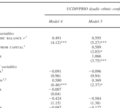
We start by considering a center-periphery model that, in addition to the logged dyadic power balance, r, includes as many independent variables as possible from Fearon and Laitin’s reference model ~see Model 4 in Table 2!+ However, we decided to drop the country-level fractionalization indices since ethnicity is measured by our proxy for relative power+ We also dropped the insignificant “noncontiguous” dummy, as it carries little meaning at the dyadic level, as well as the “new state” indicator, whose influence is largely captured by the peace-years variable+ Finally, due to the uneven temporal distribution of ethnic conflicts, with a relatively higher share occur-ring after the Cold War, we introduce a trend variable based on calendar years+
The results are striking+ As we anticipate from the exclusion perspective ~hypoth-esis 1!, the dyadic power balance has a positive and significant effect; the likeli-hood of ethnic conflict increases as the peripheral group’s relative size goes up+ The marginal impact is quite substantial as well+ An increase in the MEG’s power from the median ~r⫽ 0+003, or 0+3 percent of the dyadic population! to the 95th percentile value ~r⫽ 0+1! corresponds to a nontrivial fivefold increase in the
prob-33+ Fearon 2003+
34+ Fearon, Kasara, and Laitin 2007+ 35+ See Beck, Katz, and Tucker 1998+
ability of conflict, all else held at median values+ By contrast, the GDP variable performs poorly, again failing to reach significance+ Of the other country-level measures, the population variable is the only one that exhibits any effect+ Even after controlling for degree of marginalization, politically excluded groups in large countries have a higher baseline probability of hosting a rebellion+ Beyond that, the increasing time trend in ethnic conflict onsets is strongly confirmed, as is the healing effect of time since the last dyadic conflict+
We now add the geographic variables: the peripheral group’s distance to the capital ~hypothesis 2a! and extent of mountainous terrain in the excluded group’s
TABLE 2. Logit analysis of onset of ethnic civil war, dyadic level
UCDP/PRIO dyadic ethnic conflict
Model 4 Model 5 Model 6
Group-level variables
demographic balance r1 0+491 0+595 0+540
~4+12!*** ~5+27!*** ~5+05!***
distance from capital1 0+589 0+817
~2+03!* ~5+47!*** mountains 1+066 1+328 ~3+75!*** ~3+91!*** Country-level variables gdp capita2 ⫺0+091 ⫺0+096 ⫺0+3001,2 ~0+96! ~0+94! ~1+17! population1,2 0+580 0+369 ~6+46!*** ~2+37!* mountains ⫺0+007 ~0+04! oil ⫺0+424 ⫺0+584 ~1+15! ~1+38! instability ⫺0+087 ⫺0+127 ~0+10! ~0+14! polity score2 0+046 0+065 ~1+39! ~2+60!** year 0+061 0+064 0+066 ~5+32!*** ~5+49!*** ~6+06!*** peace years ⫺0+264 ⫺0+254 ⫺0+279 ~4+42!*** ~4+25!*** ~4+30!*** Constant ⫺126+799 ⫺134+436 ⫺135+095 ~5+64!*** ~5+75!*** ~6+52!*** N 32,720 32,720 33,882
Notes: r represents the size of the marginalized ethnic group ~MEG!, relative to the joint population of the MEG and
the ethnic group~s! in power ~EGIP!+ Models 4–5 cover the 1946–99 period, Model 6 covers the years from 1950– 2001+ Robust absolute z scores, clustered on countries, are given in parenthesis+ Estimates for three natural cubic splines not shown+ UCDP⫽ Uppsala Conflict Data Collection+ PRIO ⫽ International Peace Research Institute, Oslo+ 1+ Lagged one year+ 2+ Log-transformed+
home region ~hypothesis 2b!+ Model 5 provides strong evidence in support of these hypotheses+ It is clear that, ceteris paribus, remote groups and groups in rough terrain are significantly more likely to be involved in conflict than those closer to the capital and those located in the plains+ The latter finding is particularly inter-esting when compared to the insignificance of the corresponding country-level mea-sure in the previous model and nicely illustrates the power of disaggregation+ Note also that the impact of country population is substantially reduced as much of its effect is captured by the correlated distance variable+ Adding the ethno-geographic variables to Model 4 boosts the influence of the already highly significant dyadic power balance+ Moreover, the democracy term is now strongly significant, imply-ing a higher baseline risk of ethnic rebellion in democratic societies+ While this finding intuitively might seem suspicious, a similar result is reported by Buhaug for separatist conflict+36
So far, we have used most of Fearon and Laitin’s relatively long list of vari-ables as the benchmark of our dyadic exploration+ However, Achen warns against uncritically adding explanatory variables and estimating large models, as this is likely to distort inference+37 In addition, several of the country-level controls are
neither appropriate nor theoretically interesting in this context+ In Model 6 and subsequent models, we thus limit the selection of country-level controls to per capita income+ We further decided to drop Fearon and Laitin’s measure in favor of Gleditsch’s GDP per capita data,38because the latter data set has fewer missing
observations and covers two additional years ~2000–2001! in the most relevant period ~though it lacks data for years before 1950!+ Moreover, we take the natural logarithm of the measure to compensate for a declining effect of one unit change with higher income values+
Apart from making the overall model better specified, Model 6 shows that drop-ping irrelevant controls further strengthens the empirical case for the geographi-cally amended ethnic exclusion perspective+ Per capita income, in contrast, once again fails to reach significance+
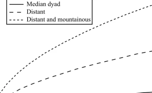
Figure 2 provides a graphic illustration of the association between r and the risk of dyadic conflict+ The lower, solid line shows the marginal effect of r, holding all other covariates at their median values+ Obviously, peripheral groups that face vastly superior EGIPs are not likely to rebel, but the risk of conflict increases markedly with the relative size of the marginalized group+ In the middle dashed plot, we changed the distance from the capital to the peripheral group from the 50th to the 95th percentile value+ This is associated with a considerably higher overall risk of conflict, as is also indicated by the positive coefficient in Model 6+ The upper, dot-ted line in the figure shows the likelihood of conflict across values of r for both mountainous ~95th percentile! and distant ~95th percentile! groups+ In line with our
36+ Buhaug 2006+ 37+ Achen 2002+ 38+ Gleditsch 2002+
hypotheses, relatively sizable marginalized groups residing in rough terrain and at a considerable distance from the capital ~such as Kurds in Iran and Bengalis in Pak-istan before 1971! are those most likely to challenge the center by violent means+
Checking the Robustness of the Dyadic Analysis
The results provide strong and compelling evidence in favor of our ethnic exclu-sion argument and simultaneously demonstrate the benefits of a disaggregated, dyad-level design+ Yet, certain aspects of the analysis deserve more consideration+ We therefore present three alternatively specified models that might help determine the robustness of the findings presented here+
First, there is a potential problem with nonindependence among time-series obser-vations of the same dyad as well as among dyads within the same country+ The data are also likely to exhibit some degree of unit heterogeneity not fully accounted for by the current selection of regressors+ While clustered standard errors address the former problem, unit heterogeneity remains largely unmeasured+ A conven-tional method to model cross-secconven-tional idiosyncrasies is to use a fixed-effects esti-mator+ This procedure essentially adds one dummy variable per unit that allows for a unique intercept, and thus an individual baseline propensity for conflict for each country case+ Model 7 in Table 3 presents the results from a fixed-effects logit analysis of the variables in the previous model+
FIGURE 2. Estimated risk of conflict as a function of the periphery’s relative
All dyad-specific explanatory variables confirm our preliminary conclusions+ Political exclusion of large ethnic cohorts poses a serious risk, and particularly so if the groups reside in inaccessible terrain and at a considerable distance from the capital+ Intriguingly, the estimate for the income variable is now significantly pos-itive, while both the trend variable and the peace-year count replicate previous results+
The fixed-effects estimator comes with certain unfortunate side-effects+ One such effect is that only units with variation on the dependent variable influences the regression estimates+ This explains the dramatic ~one-third! decrease in the num-ber of observations in Model 7 compared to the previous model; all dyads in all countries without conflict in the sample period are by design dropped from the analysis+ Yet, some of the excluded cases may have avoided conflict because of the very attributes on the explanatory variables+ Deeming these cases irrelevant makes little sense+39
39+ Beck and Katz 2001+
TABLE 3. Alternative specifications, dyadic level
Country fixed effects Static analysis
Fearon /Laitin dyadic ethnic war
Model 7 Model 8 Model 9
Group-level variables
demographic balance r1 0+603 0+614 0+884
~7+01!*** ~5+09!*** ~3+94!***
distance from capital1 1+410 0+610
~4+84!*** ~3+27!*** mountains 1+324 0+790 ~2+90!** ~1+68! Country-level variables gdp capita1,2 1+266 ⫺0+266 ⫺0+436 ~2+14!* ~1+16! ~1+96!* year 0+046 0+014 ~2+84!** ~0+80! peace years ⫺0+101 ⫺0+329 ~1+68! ~1+36! Constant ⫺1+868 –25+823 ~0+88! ~0+79! N 21,218 867 7,627
Notes: Model 7 uses a fixed-effects logit estimator of dyadic ethnic conflict, 1950–2001+ Model 8 is a cross-sectional
model of dyadic conflict, 1950–2001, with earliest available data on power ratio and GDP+ Model 9 uses a dyadic version of Fearon and Laitin’s civil war data, 1950–99 ~Fearon and Laitin 2003! with dyadic power balance, r, cal-culated from group measures in Fearon 2003+ Absolute z scores ~robust in Model 8, clustered on countries in Model 9! are given in parenthesis+ Estimates for three natural cubic splines ~Models 7 and 9! not shown+ 1+ Lagged one year+ 2+ Log-transformed+
Second, our ethno-geographic measures are in essence snapshots at one point in time, and the power balance, too, is static in most cases+ A lack of temporal vari-ation on key explanatory variables means that the model is not well-suited to pre-dict the timing of conflict onset+ Thus we next conduct a strictly cross-sectional analysis, with only one observation per dyad+ In this case, the binary dependent variable distinguishes between dyads that exhibited one or more conflicts during the sample period and those that remained at peace+ The time-varying covariates, dyadic power balance and GDP, are fixed at the earliest available figures for each dyad+
Model 8 shows the results from the static analysis+ By and large, our main results are once again confirmed+ Above all, the dyadic power ratio retains its powerful influence on the likelihood of ethnic conflict+ A center-periphery dyad with median values on all covariates has an estimated risk of experiencing at least one conflict between 1946 and 2003 of p⫽ +05+ An otherwise similar dyad for which the mar-ginalized group is relatively large ~r set at the 95th percentile value, correspond-ing to a still hefty 90–10 power preponderance in favor of the EGIP! is six times more likely to be engaged in conflict, with p⫽ +30+ The two ethno-geographic vari-ables also hold up quite well, even though the parameter estimates have shrunk and the rough terrain proxy is significant with only a 90 percent confidence threshold+ The effect for per capita income is still not even remotely significant+
A final sensitivity test remains+ Up to this point, our dyadic analysis has hinged entirely on the ethnic data of the ANM and the conflict data of the UCDP0PRIO ACD+ Since these data sets deviate from alternative sources in important ways, one might speculate whether our results are artifacts of specific sample selection criteria and variable operationalizations+ In particular, the ANM identifies a very large number of ethnic groups, many of which are clearly not politically relevant+ It does not, however, capture demonstrably critical sectarian cleavages, for exam-ple, in Arab countries+ The GIS-based method of generating group population esti-mates could also introduce measurement errors+ Similarly, the ACD’s inclusive definition of intrastate conflict ~at least twenty-five annual battle-deaths! implies that the sample of conflicts are dominated by low-level insurgencies not consid-ered “civil wars” by competing providers of conflict data+ Hence, in Model 9 ~Table 3! we replicate the analysis on Model 6 with a dyadic version of Fearon and Laitin’s ethnic civil war data, using Fearon’s group list and its associated group size values to construct the dyadic power balance indicator+ Unlike the ANM, Fearon’s ethnicity data contain no information on the location of the ethnic groups, so we are not able to test the robustness of hypotheses ~2a! and ~2b! here+
The results again provide strong and compelling support for the ethno-nationalist exclusion approach+ Even with an entirely different group list and conflict data with a considerably higher minimum casualty threshold, hypothesis ~1! holds+ We also note that by dropping the geographic factors and using a sample of major civil wars only, the GDP per capita measure regains its negative and significant effect+ The temporal control variables in Model 9 exert little impact on the overall fit of the model+
We also performed a series of other sensitivity analyses ~not reported here! that confirm the robustness of our main findings+ The results for the dyadic power bal-ance and ethno-geographic measures remain if we control for the number of groups in each country, multiple simultaneous conflicts, various types of spatial and tem-poral patterns, or apply a different temtem-poral threshold for coding recurring onsets+ Applying a minimum r-score threshold to exclude “politically irrelevant” MEGs, successively removing the cases with the highest r-scores, or dropping the coun-tries with the highest frequencies of dyadic conflict, made no significant differ-ence either+ Our results are also robust to exclusion of the Middle East region, which could be considered problematic due to the ANM’s lack of distinction between Shia and Sunni Islam+
Conclusion
By disaggregating civil wars to the level of ethnic center-periphery dyads, this study underlines the importance of politicized ethnicity as a major factor driving internal conflict+ Our research thus casts further doubt on recent studies that reject ethnic grievances as determinants of civil wars+ From a policy perspective, this is an important insight because of the prominence that such studies have gained through the sponsorship of the World Bank and other international organizations+ More specifically, we are able to say something about why ethnic configura-tions have an impact on conflict behavior+ Expecting powerful disgruntled ethnic minorities to be a major source of conflict, the dyadic perspective adopted here vindicates, and extends, Wimmer’s theory of ethno-nationalist exclusion+40
Center-periphery dyads characterized by such demographic asymmetries stand a much higher risk of civil war+
Our results also suggest that such an explanation interacts with ethno-geographic conditions+ Other things being equal, ethnic groups far from their state capitals tend to be more prone to involvement in ethnic civil wars+ The same can be said for those groups located in rough terrain+ Geographic factors of this type can be seen as important refinements of highly aggregated measures of terrain41and cruder
power estimations based merely on demographic group sizes+42
Obviously, the current study is far from the final word on the influence of eth-nicity on conflict+ It should once again be emphasized that because of data limita-tions, we have confined ourselves to the study of Eurasia and North Africa+ Future work will reveal if our conclusions hold up for the remaining world+43 There is
also plenty of room for improvement as regards the geographic calculations+ With
40+ Wimmer 2002+
41+ For example, Fearon and Laitin 2003+ 42+ Cederman and Girardin 2007+
43+ We do so in the ongoing project “Expert Survey on Ethnic Groups ~ESEG!”; see Cederman, Girardin, and Wimmer 2006+
better data, one might be able to account for the quality of local communication infrastructure+ The power estimation could also profit by relying on additional empirical dimensions, including data on mobilization and organizational structure of the groups in question+
For the time being, however, we advise against reducing civil wars to primarily greedy behavior, sheer criminality, or terrorist activities+ The unresolved Israeli-Palestinian conflict, and mounting ethno-nationalist tensions within occupied Iraq, prove that ethnic nationalism is far from a spent force+ If our findings are correct, this is a widespread problem that cries out for negotiated solutions+ Military inter-ventions that turn a blind eye to ethnic exclusion or try to manipulate the ethnic balance of power can be expected to foster future tension threatening to spill over international borders, as illustrated by those launched by the United States in Iraq in 2003 or by Israel in Lebanon in 2006+ Although we have focused on civil wars here, it would be a mistake to underestimate the transgressing and border-transforming influence of nationalism in today’s world+ Future research will show how transnational ethnic links and international interventions interact with the exclu-sion mechanisms explored in the current study+
References
Achen, Christopher H+ 2002+ Toward a New Political Methodology: Microfoundations and ART+ Annual
Review of Political Science 5:423–50+
Beck, Nathaniel, and Jonathan N+ Katz+ 2001+ Throwing out the Baby with the Bath Water: A Com-ment on Green, Kim, and Yoon+ International Organization 55 ~2!:487–95+
Beck, Nathaniel, Jonathan N+ Katz, and Richard Tucker+ 1998+ Taking Time Seriously: Time-Series– Cross-Section Analysis with a Binary Dependent Variable+ American Journal of Political Science 42 ~4!:1260–88+
Boulding, Kenneth+ 1962+ Conflict and Defense: A General Theory+ New York: Harper & Row+ Bruk, Salomon I+, and V+ S+ Apenchenko+ 1964+ Atlas Narodov Mira+ Moscow: Academy of Science,
USSR+
Buhaug, Halvard+ 2006+ Relative Capability and Rebel Objective in Civil War+ Journal of Peace Research 43 ~6!:691–708+
———+ 2007+ Dude, Where’s My Conflict? LSG, Relative Strength, and the Location of Civil War+ Unpublished manuscript, International Peace Research Institute, Oslo, Norway+
Buhaug, Halvard, and Jan Ketil Rød+ 2006+ Local Determinants of African Civil Wars, 1970–2001+
Political Geography 25 ~3!:315–35+
Cederman, Lars-Erik, and Luc Girardin+ 2007+ Beyond Fractionalization: Mapping Ethnicity onto Nation-alist Insurgencies+ American Political Science Review 101 ~1!:173–85+
Cederman, Lars-Erik, Luc Girardin, and Andreas Wimmer+ 2006+ Getting Ethnicity Right: An Expert Survey on Power Distributions Among Ethnic Groups+ Paper presented at the 102d Annual Meeting of the American Political Science Association, August–September, Philadelphia+
Cederman, Lars-Erik, Jan Ketil Rød, and Nils Weidmann+ 2006+ Geo-Referencing of Ethnic Groups: Creating a New Dataset+ Unpublished manuscript, ETH, Zürich, Switzerland+
Center for International Earth Science Information Network ~CIESIN!+ 2005+ Gridded Population of the World Version 3 ~GPWv3!+ Available at ^http:00sedac+ciesin+columbia+edu0gpw&+ Accessed 13 January 2008+
Collier, Paul, and Anke Hoeffler+ 2004+ “Greed and Grievance in Civil Wars+” Oxford Economic Papers 56 ~4!:563–95+
DeNardo, James+ 1985+ Power in Numbers: The Political Strategy of Protest and Rebellion+ Princeton, N+J+: Princeton University Press+
Fearon, James D+ 2003+ Ethnic and Cultural Diversity by Country+ Journal of Economic Growth 8 ~2!:195–222+
Fearon, James D+, Kimuli Kasara, and David Laitin+ 2007+ Ethnic Minority Rule and Civil War Onset+
American Political Science Review 101 ~1!:187–93+
Fearon, James D+, and David D+ Laitin+ 2003+ Ethnicity, Insurgency, and Civil War+ American Political
Science Review 97 ~1!:75–90+
Gleditsch, Kristian S+ 2002+ Expanded Trade and GDP Data+ Journal of Conflict Resolution 46 ~5!: 712–24+
Gleditsch, Nils Petter, Peter Wallensteen, Mikael Eriksson, Margareta Sollenberg, and Håvard Strand+ 2002+ Armed Conflict 1946–2001: A New Dataset+ Journal of Peace Research 39 ~5!:615–37+ Goemans, Hein, Kristian Skrede Gleditsch, Giacomo Chiozza, and Jinhee L+ Choung+ 2004+ Archigos:
A Database on Political Leaders+ Unpublished manuscript, University of Rochester, N+Y+; and Uni-versity of California San Diego+
Gurr, Ted Robert+ 2000+ Peoples Versus States: Minorities at Risk in the New Century+ Washington, D+C+: United States Institute of Peace Press+
Hegre, Håvard, and Nicholas Sambanis+ 2006+ Sensitivity Analysis of Empirical Results on Civil War Onset+ Journal of Conflict Resolution 50 ~4!:508–35+
Horowitz, Donald L+ 1985+ Ethnic Groups in Conflict+ Berkeley: University of California Press+ McCarthy, John D+, and Mayer N+ Zald+ 1977+ Resource Mobilization and Social Movements: A
Par-tial Theory+ American Journal of Sociology 82 ~6!:1212– 41+
Most, Benjamin A+, and Harvey Starr+ 1989+ Inquiry, Logic, and International Politics+ Columbia: Uni-versity of South Carolina Press+
Rokkan, Stein+ 1999+ State Formation, Nation-Building, and Mass Politics in Europe: The Theory of
Stein Rokkan, edited by Peter Flora, Stein Kuhnle, and Derek Urwin+ Oxford, U+K+: Oxford
Univer-sity Press+
Ross, Michael+ 2006+ A Closer Look at Oil, Diamonds, and Civil War+ Annual Review of Political
Science 9:265–300+
Sambanis, Nicholas+ 2004+ Using Case Studies to Expand Economic Models of Civil War+
Perspec-tives on Politics 2 ~2!:259–79+
Tarrow, Sidney+ 2007+ Inside Insurgencies: Political Violence in an Age of Civil War+ Perspectives on
Politics 5 ~3!:587– 600+
Taylor, Charles L+, and Michael C+ Hudson+ 1972+ World Handbook of Political and Social Indicators+ 2d ed+ New Haven, Conn+: Yale University Press+
United Nations Environmental Program ~UNEP!0World Conservation Monitoring Centre ~WCMC!+ 2002+ Mountain Watch+ New York: UNEP and WCMC+
Wimmer, Andreas+ 2002+ Nationalist Exclusion and Ethnic Conflict: Shadows of Modernity+ Cam-bridge, Mass+: Cambridge University Press+