HAL Id: hal-00296988
https://hal.archives-ouvertes.fr/hal-00296988
Submitted on 26 Apr 2007
HAL is a multi-disciplinary open access
archive for the deposit and dissemination of
sci-entific research documents, whether they are
pub-lished or not. The documents may come from
teaching and research institutions in France or
abroad, or from public or private research centers.
L’archive ouverte pluridisciplinaire HAL, est
destinée au dépôt et à la diffusion de documents
scientifiques de niveau recherche, publiés ou non,
émanant des établissements d’enseignement et de
recherche français ou étrangers, des laboratoires
publics ou privés.
Improved nowcasting of precipitation based on
convective analysis fields
M. Steinheimer, T. Haiden
To cite this version:
M. Steinheimer, T. Haiden. Improved nowcasting of precipitation based on convective analysis fields.
Advances in Geosciences, European Geosciences Union, 2007, 10, pp.125-131. �hal-00296988�
www.adv-geosci.net/10/125/2007/ © Author(s) 2007. This work is licensed under a Creative Commons License.
Geosciences
Improved nowcasting of precipitation based on convective analysis
fields
M. Steinheimer1and T. Haiden2
1Institute for Meteorology and Geophysics, University of Vienna, Austria 2Central Institute for Meteorology and Geodynamics, Vienna, Austria
Received: 8 July 2006 – Revised: 18 January 2007 – Accepted: 30 January 2007 – Published: 26 April 2007
Abstract. The high-resolution analysis and nowcasting
sys-tem INCA (Integrated Nowcasting through Comprehensive
Analysis) developed at the Austrian national weather service
provides three-dimensional fields of temperature, humidity, and wind on an hourly basis, and two-dimensional fields of precipitation rate in 15 min intervals. The system operates on a horizontal resolution of 1 km and a vertical resolution of 100–200 m. It combines surface station data, remote sensing data (radar, satellite), forecast fields of the numerical weather prediction model ALADIN, and high-resolution topographic data. An important application of the INCA system is now-casting of convective precipitation. Based on fine-scale tem-perature, humidity, and wind analyses a number of convec-tive analysis fields are routinely generated. These fields in-clude convective boundary layer (CBL) flow convergence and specific humidity, lifted condensation level (LCL), con-vective available potential energy (CAPE), concon-vective inhi-bition (CIN), and various convective stability indices. Based on the verification of areal precipitation nowcasts it is shown that the pure translational forecast of convective cells can be improved by using a decision algorithm which is based on a subset of the above fields, combined with satellite products.
1 Introduction
There is an increasing demand for automated high-quality very-short-range forecasts and nowcasts not just of precip-itation but also temperature, wind, humidity, cloudiness, or global radiation. Real-time flood-warning systems based on detailed hydrological modeling require meteorological in-put on small scales and at high update frequencies. High-resolution road weather forecasts become increasingly im-portant both for winter road management and for
transporta-Correspondence to: T. Haiden
tion planning. In response to these requirements the anal-ysis and nowcasting system INCA (Integrated Nowcasting through Comprehensive Analysis) has been developed at ZAMG (Central Institute for Meteorology and Geodynam-ics, Vienna, Austria). Section 2 gives a short overview of its general characteristics, data sources, and the analysis and nowcasting methods used.
Most existing observation-based forecasting systems have been designed for the prediction of precipitation and con-vective phenomena (Browning and Collier, 1989; Li et al., 1995; Hand, 1996; Golding, 1998; Pierce et al., 2000). Dur-ing the World Weather Research Program (WWRP) Forecast Demonstration Project (FDP) of the 2000 Sydney Olympics several systems were tested and compared (Pierce et al., 2004). A wind analysis and nowcasting system was also tested and evaluated during that project (Crook and Sun, 2004). The work, however, was not primarily focused on the wind field as such but on its use for the prediction of the initiation and development of deep convection (Wilson and Schreiber, 1986; Wilson et al., 2004). Similarly, analysis and nowcasting of near-surface temperature (Sun and Crook, 2001) has been of interest mainly in the prediction of con-vective developments rather than as a forecast field in itself.
These systems use different methods of determining pre-cipitation movement such as area tracking, individual cell tracking, and numerical weather prediction (NWP) model winds. Two of the systems, namely GANDOLF (MetOf-fice, Exeter, UK) and ANC (NCAR, Boulder, CO, USA) also have convective evolution and initiation capability (Wilson et al., 2004). In the GANDOLF system, convective cells are classified into different stages of development. Based on a conceptual model of storm evolution, future states are pre-dicted. New (“daughter”) cells can be initiated close to ex-isting cells if the boundary layer convergence predicted by the NWP model is sufficiently strong. The ANC predicts cell initiation and evolution based on the interaction of existing storms and cumulus clouds with boundary layer convergence
126 M. Steinheimer and T. Haiden: Improved nowcasting of precipitation based on convective analysis fields
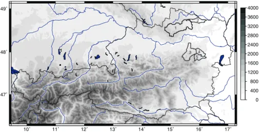
Fig. 1. INCA domain and topography (meter above mean sea level). Domain size is 600×350 km, horizontal resolution is 1 km. River catchments referred to in the study are Kamp (1), Pulkau (2), Traisen (3), Triesting (4), and Piesting (5).
lines observed by radar and predicted by NWP wind field characteristics. The main findings with regard to convective cell prediction in the Sydney FDP can be summarized as fol-lows (Wilson et al., 2004):
1. Predictive skill above pure translation occurs when boundary layer convergence lines can be identified and used to nowcast cell evolution.
2. For nowcasts beyond 60 min, boundary characteristics are more important for storm initiation than early detec-tion of cumulus clouds.
For the development of a cell initiation and evolution mod-ule in INCA, described in Sect. 3, these results served as a guideline. They also indicate the importance of a good boundary-layer wind field analysis. In Austria’s alpine ter-rain, boundary layer convergence lines are to a large degree related to topography, which adds a deterministic component to cell initiation (Haiden, 2001). With the current version of the INCA wind field analysis the ability to correctly detect these convergence lines critically depends on the skill of the ALADIN1model in predicting them, and on the surface sta-tion network to represent them. Case studies are carried out to determine to what extent this is in fact the case. However, none of the systems used in the Sydney FDP used convective analysis fields such as CAPE or CIN, so it is interesting to investigate what additional benefit can be gained from those. Results of the case studies are discussed in Sect. 4.
1ALADIN is a limited area weather prediction model (LAM).
In this study ALADIN-VIENNA is used, that runs operationally at ZAMG. (horizontal resolution: 9.6 km).
2 The INCA system
The forecast of an NWP model is trilinearly interpolated to the high-resolution (1 km) INCA grid, serving as a first guess. Differences between surface observations and the first guess are determined and spatially interpolated using inverse distance weighting (IDW) both in geometric and in physi-cal space. In the case of temperature, for example, geomet-rical distance weighting is used in the horizontal, while in the vertical the distance weighting is performed in potential temperature (θ ) space. The three-dimensional “distance” be-tween INCA gridpoint (i, j, m) and the k-th surface station is given by
rij mk = q
(xk− xi)2+ (yk− yj)2+ c2(θkNWP− θij mNWP)2,
(1) where the parameter c has the dimension of an inverse perature gradient. The interpolated three-dimensional tem-perature difference field is obtained from
1θ (i, j, m) = P k θOBS k −θkNWP rij mk2 P k 1 rij mk2 (2)
and added to the NWP first guess, giving
θINCA(i, j, m) = θNWP(i, j, m) + 1θ(i, j, m). (3) In case of wind a relaxation algorithm is applied to the in-terpolated field in order to obtain mass-consistency. The cur-rent downscaling procedure in INCA is purely kinematic and cannot introduce dynamical flow effects such as mountain waves or foehn if these phenomena are not already present in the NWP field or the observations. The same applies to boundary layer convergence. Hence, the resulting conver-gence is sensitive to the quality of the first guess provided by
the NWP. In areas with orographically induced convergence good results are achieved, as pointed out in Sect. 4.
INCA routinely analyzes three-dimensional fields with one hour update interval (temperature, humidity, wind), two-dimensional fields with one hour update interval (global radi-ation, convective analysis fields) and two-dimensional fields with 15 minutes update interval (cloudiness, precipitation). Analyses and nowcasts of these fields have been operational since 2005.
The high resolution of 1 km is an essential characteris-tic of INCA. It enables the system to process locally influ-enced station observations, because at this resolution the ac-tual elevation and exposition of most surface stations coin-cides reasonably well with the corresponding values on the numerical grid. In steep terrain the resolution is still not en-tirely adequate but it is an operationally feasible compromise for a domain size encompassing the entire area of Austria (600×350 km, Fig. 1). Another reason for using a 1 km grid is that it corresponds to the resolution of the radar data used in INCA.
In the vertical, a z-system is used where z is the height above the “valley-floor surface”. In mountainous or hilly ter-rain, the valley-floors of adjacent valleys are generally found at comparable heights. Thus one may define a hypothetical surface that is smooth compared to the actual topography and connects major valley-floors (Haiden, 1998). This surface represents a useful local reference height for the z-System. The vertical resolution of INCA is currently equidistant at
1z=200 m. The system has 21 levels (surface included)
par-allel to the valley-floor surface, covering the lowest 4000 m above this surface. For the wind analysis a z-coordinate with horizontal levels and 1z=125 m is used. The irregular shape and reduced volume of grid elements intersecting the ter-rain is taken into account using the shaved element approach (Steppeler et al., 2002).
ALADIN forecast fields are used as a first guess for the three-dimensional INCA analyses (temperature, humid-ity, wind). The NWP fields are 1-hourly, at a horizontal resolution of 9.6 km, with 45 levels in the vertical. Two ALADIN forecast runs per day are performed (00:00 UTC, 12:00 UTC). Post-processed fields from these runs are avail-able at about 05:00 UTC and 17:00 UTC. ALADIN fore-cast fields used in INCA are geopotential, temperature, rela-tive humidity, u-, v-, w- wind components (3-d fields), 2 m temperature and relative humidity, u-, v- 10 m-wind compo-nents, precipitation, total cloudiness, and low cloudiness (2-d fields).
The most important observational data for the INCA sys-tem are surface stations. ZAMG operates a network of ∼140 automated stations (TAWES) across the country. In the ver-tical, they span most of the topographic range in Austria, with highest stations Brunnenkogel (3440 m), and Sonnblick (3105 m). Although the distribution of stations is biased to-wards valley locations, there is a sufficient number of moun-tain stations to construct three-dimensional correction fields
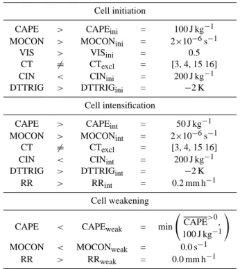
Table 1. Convective nowcast algorithm decision criteria and thresh-old values for cell initiation, intensification, and weakening.
Cell initiation
CAPE > CAPEini = 100 J kg−1
MOCON > MOCONini = 2×10⁻⁶s−1
VIS > VISini = 0.5
CT 6= CTexcl = [3, 4, 15 16]
CIN < CINini = 200 J kg−1
DTTRIG > DTTRIGini = −2 K
Cell intensification
CAPE > CAPEint = 50 J kg−1 MOCON > MOCONint = 2×10⁻⁶s−1
CT 6= CTexcl = [3, 4, 15 16]
CIN < CINint = 200 J kg−1
DTTRIG > DTTRIGint = −2 K
RR > RRint = 0.2 mm h−1
Cell weakening
CAPE < CAPEweak = min CAPE >0
,
100 J kg−1
!
MOCON < MOCONweak = 0.0 s−1 RR > RRweak = 0.0 mm h−1
to the NWP model output on the basis of these observations. Radar data used in INCA is a 2-d composite of four radar stations with ground clutter already removed. The data has 14 intensity categories and a time resolution of 5 min. Due to the mountainous character of the country, radar data is of limited use in many areas in western Austria, especially dur-ing wintertime when precipitation can originate from shallow cloud systems. The Meteosat 2nd Generation (MSG) satellite provides a number of new fields as well as a higher resolu-tion than previous Meteosat imagery. The satellite products used in INCA are visible brightness and “Cloud Type” which differentiates between different cloud levels (low, medium, high) and different degrees of opaqueness.
3 Convective nowcast algorithm
The INCA translational precipitation nowcast is an observation-based extrapolation that uses motion vectors de-termined from consecutive analyses with a correlation tech-nique. The size of the correlation quadrangle is 100 km. Spu-rious correlations implying unrealistically large translation speeds are meteorologically filtered by comparison with AL-ADIN wind fields at 500 und 700 hPa. The filtering is done using the condition
128 M. Steinheimer and T. Haiden: Improved nowcasting of precipitation based on convective analysis fields where VKORR is the motion vector derived by
correla-tion analysis, VALA is the ALADIN 500 or 700 hPa wind
(whichever is closer to VKORR), and 1 is a prescribed wind
speed scale which determines the amount of deviation per-mitted between VKORRand VALA. Operationally, the value 1=5 ms−1 is used. Equation (4) defines an elliptic area aligned with the vector VALA. Verification of both point
and areal precipitation forecasts shows that the INCA trans-lational nowcast is superior to NWP forecasts over the first 2–4 h.
In order to improve the convective precipitation forecast over that of a simple translation, the evolution (initiation, intensification, weakening) of convective cells must be as-sessed. Once every hour INCA routinely generates the con-vective analysis fields of lifted condensation level (LCL), level of free convection (LFC), convective available
poten-tial energy (CAPE), convective inhibition (CIN), Showalter
index (SWI), lifted index (LI), trigger temperature deficit
(DTTRIG), equivalent potential temperature (θe), boundary-layer convergence (CON) and boundary-boundary-layer humidity
con-vergence (MOCON). During the period of algorithm
devel-opment several different combinations of these fields were tested. The ones that proved most useful and were ultimately used are indicated by italics.
The basic concept of the INCA convective nowcast algo-rithm is to classify each gridpoint as either “convective” (us-ing the condition that CAPE>50 J kg−1within a certain dis-tance from the gridpoint) or “non-convective”. For each con-vective gridpoint it is tested whether the conditions for cell initiation, cell intensification, or cell weakening are fulfilled (Table 1). In addition to the above fields, Table 1 contains criteria based on MSG satellite data, namely visible bright-ness and cloud type information:
– Visible brightness (VIS) is used to identify areas
where non-precipitating cumulus convection is already present. Only in these areas cell initiation is allowed. VIS is scaled to its domain maximum value at a given time to allow the use of a constant threshold value (Ta-ble 1) throughout the daytime diurnal cycle. The current algorithm is unable to predict initiation after sunset.
– Cloud Type (CT) is used to exclude those areas from
initiation and intensification where obviously no con-vective cloudiness is present. This applies to follow-ing types: cloud free land snow (CT=3), cloud free
sea snow/ice (CT=4), high semi-transparent thin clouds
(CT=15), high semi-transparent thick clouds (CT=16). An additional condition, that the precipitation rate (RR) must be greater than a certain threshold value, had to be ap-plied in order to avoid intensification of very small precipi-tation rates that are sometimes generated in the analysis as a result of station interpolation.
The convective nowcast is created as follows:
– The analyzed precipitation field is moved according to
the motion vectors for the length of one time step 1t .
– The new intensity is calculated at gridpoints where the
criteria of Table 1 are fulfilled using Eq. (6); otherwise the intensity is left unchanged.
– The modified field is moved according to the motion
vectors for the length of another time step and again the intensity is updated at the appropriate gridpoints.
– This procedure is repeated till the end of the nowcast
period.
All three types of intensity changes (initiation, intensifica-tion, and weakening) are modeled as a Gaussian variation in time I (t ) = IMAXexp ( −h(t − tMAX) | {z } tREL /τi2 ) , (5)
where the three parameters IMAX (maximum rainfall rate), tMAX(time of maximum rainfall rate) or rather tREL(time of
maximum rainfall rate relative to time t ), and τ (cell evolu-tion time-scale) must be determined.
The resulting precipitation intensity at time t+1t is then given by I (t + 1t) = IMAXexp ( − h (1t + tREL)/τ i2) . (6)
Maximum cell intensity is parameterized as a function of specific humidity q (at valley-floor level) and CAPE in the form
IMAX = c1ρq √
CAPE, (7)
where ρ=1 kg m−3, and the nondimensional coefficient c1=1/90.
In the case of initiation and intensification τ is set to the constant value τG=1800 seconds.
The time of maximum intensity of a newly initiated cell relative to time t is set to tREL=−2τG. For cell intensifi-cation tREL is derived from the ratio of maximum intensity
to intensity at time t by inverting Eq. (6) and setting 1t=0, which gives
tREL= −τG p
ln[IMAX/I (t )], (8)
where IMAXis parameterized using Eq. (7).
In the case of cell weakening it is assumed that tREL=0,
IMAX=I (t). The timescale of weakening (in units of
sec-onds) is parameterized based on moisture convergence
τD = − c2
MOCON, (9)
where c2=9×10⁻⁴. In addition, τD is limited by the con-straint 1800≤τD≤3600 seconds.
Kamp
15 30 45 60 75 90 105 120 forecast time [min]
−0.5 0.0 0.5 1.0 1.5 2.0 2.5 3.0 3.5 [mm] MEcn RMSEcn MEtn RMSEtn Pulkau 15 30 45 60 75 90 105 120 forecast time [min]
−0.5 0.0 0.5 1.0 1.5 2.0 2.5 3.0 3.5 [mm] MEcn RMSEcn MEtn RMSEtn Traisen 15 30 45 60 75 90 105 120 forecast time [min]
−0.50.0 0.5 1.0 1.5 2.0 2.5 3.0 3.5 4.0 4.5 5.0 5.5 6.0 [mm] MEcn RMSEcn MEtn RMSEtn Triesting 15 30 45 60 75 90 105 120 forecast time [min]
−0.5 0.0 0.5 1.0 1.5 2.0 2.5 3.0 3.5 4.0 4.5 5.0 5.5 6.0 [mm] MEcn RMSEcn MEtn RMSEtn Piesting 15 30 45 60 75 90 105 120 forecast time [min]
−0.50.0 0.5 1.0 1.5 2.0 2.5 3.0 3.5 4.0 4.5 5.0 5.5 6.0 [mm] MEcn RMSEcn MEtn RMSEtn
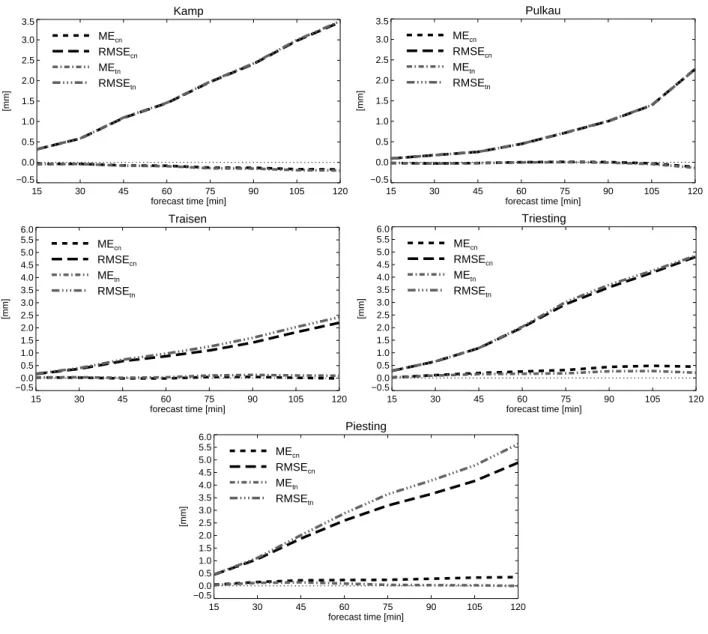
Fig. 2. Verification results for the non-alpine catchments Kamp and Pulkau, and the alpine catchments Traisen, Triesting, Piesting. Shown are the root-mean-square error (RMSE) and bias (ME) of areal precipitation nowcasts as a function of forecast time for the convective nowcast “cn” and the pure translational nowcast “tn”.
4 Results and discussion
Verification of the convective nowcast algorithm is per-formed for five small river catchments (Fig. 1) in different parts of the province of Lower Austria with terrain ranging from hilly (Kamp, Pulkau) to moderately alpine (Traisen, Triesting, Piesting). Catchment sizes range from 250 km2 (Piesting) to 1500 km2(Kamp). It was decided to verify areal rather than point forecasts because of their greater relevance to hydrological applications and because we did not want to penalize small location errors of the order of a few km. The forecast range considered is +15 to +120 min, verifica-tion measures are root-mean-square error (RMSE) and bias
(or mean error, ME) of accumulated precipitation, computed against INCA analyses. Results of the convective nowcast al-gorithm are compared to those obtained by pure translation. The verification period consists of all forecasts made at full hours between 11:00 and 18:00 UTC for those 10 days of the year 2005 which had the highest convective rainfall amounts in Lower Austria. All days fell within the period May–July.
When interpreting the verification results of the convective nowcast it must be kept in mind that a systematic improve-ment above pure translation is generally hard to achieve. By predicting intensity changes, in particular in the case of ini-tiation and intensification, the convective nowcast takes a greater “risk” than the translation. Our attempt was to design
130 M. Steinheimer and T. Haiden: Improved nowcasting of precipitation based on convective analysis fields an algorithm that gives significant improvements in
individ-ual cases without worsening the overall skill. On the other hand, the verification periods considered here cannot be con-sidered entirely independent since they contain cases that have been used in the design of the algorithm. Thus we ex-pected to see improvements at least in some of the areas.
Figure 2 shows the RMSE and ME for the translational and the convective nowcast. In the non-alpine areas the results are essentially neutral. Analysis of individual cases in these areas shows a number of days where there is in fact an im-provement due to the convective nowcast but this is compen-sated by worsening on other days. Results for the alpine areas show a significant improvement in terms of RMSE for Piest-ing and Traisen, and rather neutral behaviour for TriestPiest-ing. In the former two areas there are also individual cases where the convective nowcast algorithm has a larger error than the translational algorithm, but overall the improvements domi-nate. One reason why the improvement is more pronounced in the alpine areas may be that, due to orographic effects, the moisture convergence is more predictable and thus better represented in the ALADIN wind field that is used as a first guess in the INCA wind analysis. This assumption is based on the observation of strong moisture convergence in the re-gion of our alpine verification areas that are well-known cli-matological “hot spots” for orographically triggered convec-tive developments. The ME tends to increase slightly in areas where the RMSE is reduced. However, this is not always the case, as shown by the results for the Traisen catchment. With regard to differences in error magnitude between catchments it is important to note that they do not indicate a difference in forecast skill but primarily reflect different precipitation amounts.
In order to confirm whether the verification results from 2005 can be generalized, an additional continuous verifica-tion was performed which covers all nowcasts made between 4 April 2006 and 16 May 2006 during a pre-operational test run of the system. In this case no individual days were se-lected, thus the sample contains a mixture of non-convective and convective cases. Again, no significant change in RMSE was found for the non-alpine areas, whereas improvements similar in extent to the 2005 verification were found for two alpine areas (Triesting, Piesting) with the third (Traisen) giv-ing neutral results.
Based on a number of individual cases, Wilson et al. (2004) provide a qualitative verification of the convective nowcast algorithm in the ANC system for up to +60 min. They demonstrate that it outperforms the purely translational forecast in most cases but also point out that further algo-rithm development is needed. In contrast to INCA, the ANC obtains wind fields derived from Doppler radar as input. It is likely that such input would increase the skill of the INCA convective nowcast especially in lowland areas, where the current wind analysis based on NWP results and station data appears to be unable to resolve the convergence character-istics relevant to convective intensity changes. Pierce et al.
(2000) made a quantitative evaluation, and comparison with pure translation, for the GANDOLF system. In contrast to INCA, GANDOLF uses an object-oriented algorithm to ex-trapolate cell movement and intensity. For all non-frontal convective events of 1995–1996, results similar to the ones presented here were obtained in the sense that both improve-ments and worsening compared to pure translation was found for different catchments.
5 Conclusions
An approach to convective nowcasting is presented which is based on high-resolution analyses of some key convective di-agnostics. It is found that the convective analysis fields most important for the nowcast are CAPE, CIN, moisture con-vergence, and trigger temperature deficit. The current ver-sion of the algorithm also requires visible satellite imagery in order to identify areas of incipient cell intensification and to avoid over-prediction of cell initiation. Verification of areal precipitation nowcasts for small catchments shows that on average the convective nowcast performs slightly better than the purely translational nowcast. The improvement is more pronounced in the alpine catchments studied, whereas it is marginal in the non-alpine areas. This difference in be-haviour appears to be due to the more predictable character of the orographically induced moisture convergence field along the main alpine rim as compared to that over the lowlands.
There are many possible ways in which the current ver-sion of the algorithm could be improved. For example, it could be argued that the thresholds set for input fields like CAPE, CIN, DTTRIG and MOCON should not be constants but rather depend on the values of the other fields at the given instant and location. Also, it would be more physical in terms of an ingredient-based approach to use mass convergence in-stead of moisture convergence. For the mesoscale structures studied here, however, the convergence term dominates MO-CON, making mass and moisture convergence fields look rather similar (Banacos and Schultz, 2005).
Probably the largest improvement could be gained by im-proved analyses of the primary fields from which the con-vective diagnostics are derived. The typical length scale of CAPE, CIN, and MOCON variations in the analysis is sig-nificantly larger than the scale of individual convective cells. The DTTRIG parameter, which is smaller in scale, is not yet sufficiently reliable. To deal with this drawback the con-vective nowcast algorithm currently uses visible satellite im-agery to decide where new precipitation cells are initiated. That means that the current nowcast algorithm is unable to predict cell initiation in clear air. Further work on INCA will address this problem through improved spatial interpolation techniques for temperature, humidity and wind.
Acknowledgements. The provincial government of Lower Austria
supported the work done within this research. Edited by: S. C. Michaelides and E. Amitai Reviewed by: anonymous referees
References
Banacos, P. C. and Schultz, D. M.: The use of moisture flux convergence in forecasting convective initiation: historical and opeational perspectives, Wea. Forecast., 20, 351–366, 2005. Browning, K. A. and Collier, C. G.: Nowcasting of precipitation
systems, Rev. Geophys., 27, 345–370, 1989.
Crook, N. A. and Sun, J.: Analysis and forecasting of the low-level wind during the Sydney 2000 Forecast Demonstration Project, Wea. Forecast., 19, 151–167, 2004.
Golding, B. W.: Nimrod: A system for generating automated very short range forecasts, Meteorol. Appl., 5, 1–16, 1998.
Haiden, T.: Analytical aspects of mixed-layer growth in complex terrain. Preprints, Eighth Conference on Mountain Meteorology, Amer. Meteorol. Soc., Flagstaff, Arizona, 368–372, 1998. Haiden, T.: High-resolution forecasts of mountain cumulus,
Pro-ceedings, 22nd EWGLAM/7th SRNWP Meeting, Toulouse, France, 134–138, 2001
Hand, W. H.: An object-oriented technique for nowcasting heavy showers and thunderstorms, Meteorol. Appl., 3, 31–41, 1996. Li, L., Schmid, W., and Joss, J.: Nowcasting of motion and growth
of precipitation with radar over a complex topography, J. Appl. Meteorol., 34, 1286–1300, 1995.
Pierce, C. E., Hardaker, P. J., Collier, C. G., and Haggett, C. M.: GANDOLF: a system for generating automated nowcasts of con-vective precipitation, Meteorol. Appl., 7, 341–360, 2000. Pierce, C. E., Ebert, E., Seed, A. W., Sleigh, M., Collier, C. G., Fox,
N. I., Donaldson, N., Wilson, J. W., Roberts, R., and Mueller, C. K.: The nowcasting of precipitation during Sydney 2000: An appraisal of the QPF algorithms, Wea. Forecast., 19, 7–21, 2004. Steppeler, J., Bitzer, H.-W., Minotte, M., and Bonaventura, L.: Non-hydrostatic atmospheric modeling using a z-coordinate represen-tation, Mon. Wea. Rev., 130, 2143–2149, 2002.
Sun, J. and Crook, N. A.: Real-time low-level wind and tempera-ture analysis using WSR-88D data, Wea. Forecast., 16, 117–132, 2001.
Wilson, J. W. and Schreiber, W. E.: Initiation of convective storms by radar-observed boundary layer convergence lines, Mon. Wea. Rev., 114, 2516–2536, 1986.
Wilson, J. W., Ebert, E. E., Saxen, T. R., Roberts, R. D., Mueller, C. K., Sleigh, M., Pierce, C. E., and Seed, A.: Sydney 2000 Forecast Demonstration Project: Convective storm nowcasting, Wea. Forecast., 19, 131–150, 2004.