15,000 Years of mass-movement history in Lake Lucerne:
Implications for seismic and tsunami hazards
M
ICHAELS
CHNELLMANN1*, F
LAVIOS. A
NSELMETTI1, D
OMENICOG
IARDINI2& J
UDITHA. M
CK
ENZIE1Key words: Mass-flow deposits, megaturbidites, lacustrine sedimentation, natural hazard, paleoseismology, seismic stratigraphy, Central Switzerland
ABSTRACT
A chronological catalogue of Late Glacial and Holocene mass-movement de-posits in Chrüztrichter and Vitznau Basins of Lake Lucerne (Vierwaldstät-tersee) reveals a complex history of natural hazards affecting the lake and its shores. Ninety-one mass-flow and six megaturbidite deposits have been identi-fied and mapped out with a grid of more than 300 km high-resolution seismic profiles. An age model based on the analyses of 10 long piston cores, 2 tephra layers and 32 AMS-14C ages allowed building up a chronological event
cata-logue covering the last 15,000 years. Most of the identified mass-flow deposits relate to subaqueous sliding and subaerial rockfalling, as indicated by slide scars and rockfall cones on the lake floor. Deposits related to subaqueous slid-ing occur at the toe of slopes with inclinations >10° and reach their largest ex-tents below slopes with inclinations between 10 and 20°. On subaqueous slopes >25° there is hardly any sediment accumulation. Rockfall cones and related mass-flow deposits in the northeastern and southern part of Vitznau basin ev-idence repeated rockfall activity, particularly along two zones on the northern face of Bürgenstock Mountain. Historic examples indicate that such rockfalls, as well as large subaqueous slides, can induce considerable tsunami waves in the lake. All of the 91 identified mass-flow deposits are associated with 19 seis-mic-stratigraphic event horizons. One of them comprises 13 mass-flow depo-sits and 2 megaturbidites and relates to the 1601 A.D. Mw~ 6.2 earthquake. By
analogy, five older multiple mass-movement horizons, each including six or more coeval deposits, are interpreted to result from strong prehistoric earth-quakes.
ZUSAMMENFASSUNG
Ein chronologischer Katalog von Rutschungsablagerungen im Untergrund von 2 Becken des Vierwaldstättersees (Chrüztrichter und Vitznaubecken) zeugt von verschiedenen Naturgefahren, welche den See und dessen Ufer beeinträchtigen. Mit Hilfe eines dichten Netzes von mehr als 300 km hochauf-lösender reflektions-seismischer Profile wurden subaquatische Abrisskanten, Bergsturzfächer, sowie 91 Rutschungs- und 6 grosse Turbiditablagerungen identifiziert und mit seismisch-stratigraphischen Methoden auskartiert. Die Analyse von 10 Langkernen, zwei Aschenlagen und 32 AMS-14C Datierungen
ermöglichten eine Altersbestimmung der Ereignisse und das Erstellen eines chronologischen Ereignis-Kataloges der letzten 15,000 Jahre. Die häufigsten und umfangreichsten subaquatischen Rutschungsablagerungen treten am Fuss von Hängen mit einer Neigung von 10-20° auf. Flachere Hänge sind meist sta-bil und Hänge >25° in der Regel zu steil, um genügend Material für grosse Rutschungen zu akkumulieren. Bergsturzfächer und vorgelagerte Rutschungs-ablagerungen im Vitznauerbecken deuten auf wiederholte Bergsturzaktivität hin, insbesondere entlang zweier Zonen am Nordabhang des Bürgenstocks. Historische Beispiele zeigen, dass solche Bergstürze sowie grosse subaqua-tische Rutschungen im See beträchtliche Flutwellen auslösen können. Die identifizierten 91 Rutschungsablagerungen und 6 Turbidite verteilen sich auf 19 seismisch-stratigraphische Ereignis-Horizonte. Ein Ereignis-Horizont, wel-cher 13 Rutschungsablagerungen und zwei Megaturbidite umfasst, wurde in Zusammenhang mit dem historisch gut dokumentierten Erdbeben im Jahr 1601 abgelagert. Analog werden fünf prähistorische multiple Rutschungsab-lagerungen ebenfalls starken Erdbeben zugeschrieben.
rockfalls. In order to achieve a more complete hazard assess-ment including such low-frequency events, the historic event catalogue needs to be extended to prehistoric times.
Lakes provide ideal sedimentary archives, which, in con-trast to most subaerial archives, are spatially and temporally continuous and can readily be dated. Characteristic event beds in lacustrine sediments have been allocated to historically de-scribed catastrophic events, such as floods (e.g. Siegenthaler & Sturm 1991a; Gilli et al. 2003; Bussmann 2006), subaerial debris 1. Introduction
Recurrance times are crucial parameters for the assessment of natural hazards, such as earthquakes, rockfalls or floods. The available time series analyses are closely bound to the exis-tence of written historical documents, which, in most of Cen-tral and Northern Europe, are limited to the last 400 to maxi-mal 1000 years. This time span is too short to provide suffi-cient knowledge about the temporal and spatial distribution of rare high-impact events, such as strong earthquakes or major
*Correspondence: E-mail: [email protected] 1 Geological Institute, ETH Zurich, 8092 Zürich, Switzerland 2 Institute of Geophysics, ETH Zurich, 8093 Zürich, Switzerland 0012-9402/06/030409-20
DOI 10.1007/s00015-006-1196-7 Birkhäuser Verlag, Basel, 2007
flows (e.g. Sletten et al. 2003), rockfalls (Lemcke 1992; Blikra et al. in press; Bussmann 2006) and shore collapses (e.g. Heim 1876, 1888, 1932; Kelts & Hsü 1980; Prior et al. 1984; Hsü & Kelts 1985; Siegenthaler & Sturm, 1991a, 1991b; Longva et. al 2003). Strong historic earthquakes left characteristic multiple mass-movement deposits at the lake/ocean floor (Shilts & Clague 1992; Schnellmann et al. 2002; Locat et al. 2003; Skinner & Bornhold 2003). Based on the fingerprints of historic events in “recent” sediments, similar prehistoric events can be recog-nized in older deposits (Schnellmann et al. 2002; Skinner & Bornhold 2003; Sletten et al. 2003).
Lake Lucerne and its surroundings are characterized by a high activity of both subaerial and subaqueous mass move-ments. Beside the direct threats caused by such events, at least three times in the last ~ 400 years, subaerial rockfalls or sub-aqueous slides have caused tsunamis and seiches in the lake. These incidents led to considerable damage along the shore-line (Bünti 1914; Billeter 1916; Cysat 1969; Huber 1980; Siegenthaler et al. 1987; Siegenthaler & Sturm 1991b). During
the Mw~ 6.2 earthquake in 1601 A.D. (Fäh et al. 2003), two
subaerial rockfalls, various shore collapses and up to 4-m-high tsunami and seiche waves appeared in the lake (Cysat 1969; Schwarz-Zanetti et al. 2003). Consequently, the sediments in Lake Lucerne represent a suitable archive for characterizing the fingerprint of historic mass-movement and earthquake events and for extending the catalogue of such incidents to prehistoric times.
The aim of the study presented in this paper is: (1) to char-acterize and distinguish deposits related to subaqueous slides and subaerial rockfalls, (2) to establish a chronological cata-logue of Late Glacial and Holocene mass-movement deposits in the Chrüztrichter and Vitznau basins of Lake Lucerne, (3) to identify and characterize hot spots with frequent past slide and rockfall activity, and (4) to recognize multiple mass-move-ment events, which were potentially triggered by strong pre-historic earthquakes.
2. Methods
In order to image the subsurface of the studied basins in quasi-3D, a grid of more than 300 km 3.5 kHz seismic lines (pinger source) was acquired in 2000 and 2001. As this study focuses on slope and base-of-slope processes, the line orientation was cho-sen perpendicular to the slopes rather than strictly parallel. The source/receiver was mounted on a cataraft that was pushed ahead by a vessel. DGPS-Positioning with a maximum error of ± 2 m guaranteed an accurate navigation. Processing of the dig-itally recorded data included a band-pass filter, an automatic gain control, a water-bottom mute and a spiking deconvolution. For conversion of two-way traveltime to water depth and
sedi-ment thickness, a constant velocity of 1500 ms-1was used.
In 2000, eight Kullenberg-type gravity piston cores (Kelts et al. 1986), each 8–10 m-long, were retrieved from key loca-tions in the Chrüztrichter and Vitznau basins. During a second coring campaign in 2002, the deeper subsurface (8–20 m) was
cored at two different sites by using an UWITEC percussion piston coring device.
Petrophysical properties of the sediments (P-wave velocity, gamma-ray density and magnetic susceptibility) were mea-sured on whole cores with a GEOTEK Multi-Sensor Core Logger. After splitting, the cores were photographed and de-scribed macroscopically. Preparation and pretreatment of
sam-ple material for AMS 14C dating was carried out in the 14C
lab-oratory of the Department of Geography at the University of Zurich. The dating itself was made using the tandem accelera-tor of the Institute of Particle Physics at ETH Zurich.
3. Study Area: Geological Setting and Historical Mass movement Activity
Lake Lucerne is a fjord-type lake of glacial origin with a total
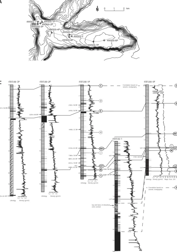
surface area of 116 km2 (Fig. 1A). It is located in Central
Switzerland at the northern alpine front and consists of seven steep-sided basins separated by subaqueous sills. Four major alpine rivers (Reuss, Muota, Engelberger Aa and Sarner Aa)
drain a large part of the catchment (2124 km2) and provide
~80% of the lakes total water supply (109 m3/s). This study
concentrates on the Chrüztrichter and Vitznau basins, which lack major active deltas and, as a consequence, show low sedi-mentation rates (Fig. 1A). The studied basins incorporate the alpine and the subalpine front, two major alpine thrusts sepa-rating (from S to N) Alpine Nappes, Subalpine Molasse and Plateau Molasse (Fig. 1A).
The southern shores of the studied basins are dominated by the steep Helvetic limestone cliffs of Bürgenstock Moun-tain. From the lake shore towards the top of Bürgenstock mountain the terrain raises about 700 m over a horizontal dis-tance of 400 m. Rockfall deposits and talus debris are abun-dant at the base of these cliffs (Buxtorf 1918). During a historic
rockfall close to Obermatt in 1964 approximately 70,000 m3of
limestone fell into the lake. The induced wave was 10–15 m-high close to the impact and still caused considerable damage on the 3.5 km distant opposite lake shore (Huber 1980). An-other rockfall at Bürgenstock occurred during the 1601 A.D. earthquake and contributed to huge water movements ob-served in the lake (Cysat 1969).
The northern shore of the Vitznau Basin is dominated by Rigi Mountain, which tectonically belongs to the Subalpine Molasse. The varying erosion resistance of individual Molasse beds results in a stepwise morphology. Parts of the steep con-glomerate cliffs frequently break away, leading to relatively small rockfalls (e.g. Kanton Luzern 2006a, 2006b). Most rock-fall deposits at the northern shore of Vitznau Basin occur be-tween Riedsort and Vitznau (Fig. 1B), e.g. the remnants of a historic rockfall, which destroyed the therapeutic baths at Lützelau in 1661 (Kanton Luzern 2006b). Prehistoric deposits in the same region point towards at least one older and consid-erably larger event (Kanton Luzern 2006b). The process of this prehistoric incident was probably similar to the 1806 Goldau rockslide, which also took place in a subalpine Molasse setting
and involved thick conglomerate Bussmann 2006 beds sliding away on marly layers (e.g. Heim 1932; Kopp 1936).
Beside rockfalls and rockslides the northern shore of Vitz-nau basin has also faced destructive debris flows and shore col-lapses: In 1674, a debris flow triggered by a landslide (Gassrübi Landslide) above Vitznau damaged the southern part of the village (Kaufmann 1872; Zimmermann 1913; Lemcke 1992). A particularly destructive event took place in 1795 A.D., when a slow-moving subaerial landslide (Rubi Landslide) broke away above the village of Weggis. Thanks to detailed historical in-formation including a map of the event, it is known that the event destroyed 28 houses and 15 barns and was over 300 m wide at the shore of the lake (Pfyffer 1795; Kanton Luzern 2006a). The debris flow triggered a sudden collapse of the lake shore, which induced a lowering of the lakebed by approxi-mately 15 m. Shore collapses happened also during the 1601
A.D. earthquake (Cysat 1969). The most serious case de-scribed for Vitznau and Chrüztrichter basins affected the vil-lage of Vitznau, where a considerable piece of flat riparian land disappeared in the lake and large cracks opened in the ground, leading to the destruction of a mill and a sawmill.
4. Sedimentation in Chrüztrichter and Vitznau basin
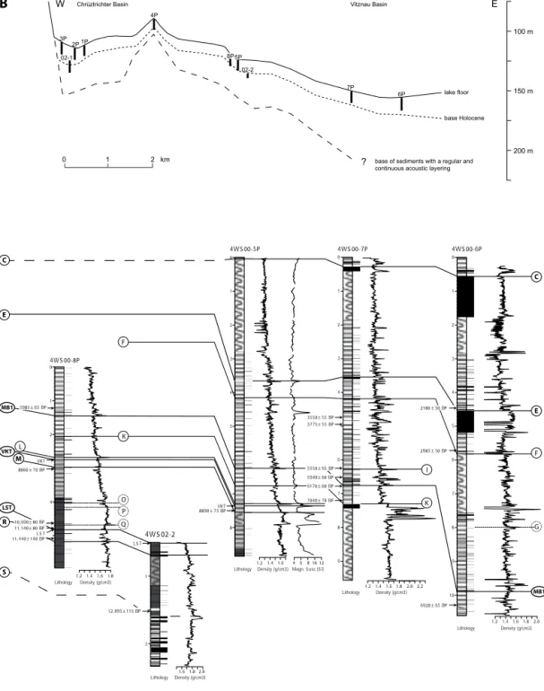
Air gun reflection seismic profiles revealed a 117 m-thick, glacio-lacustrine infill in the central part of the Vitznau Basin (Finckh et al. 1984). The majority of these sediments were de-posited in the Late Glacial period and only the uppermost 5 to 15 m are of Holocene age. Cores through the uppermost part of the Late Glacial sediments reveal thinly laminated light gray to yellowish mud with frequent intercalated graded turbidite beds of brown, gray and beige color. The Holocene sediments Fig. 1. A. Lake Lucerne and surroundings. The dotted and dashed-dotted lines mark the alpine front (AF) and the subalpine front (SAF), respec-tively. These two major thrusts separate the three main tectonic units of the area, which are, from north to south, the Plateau Molasse, the Sub-alpine Molasse and the Alpine Nappes (Helvetic Nappes and Penninic cliffs). The X’s indicate the deepest points of the seven basins of the lake: Alpnach Basin (AB), Chrüztrichter Basin (CB), Gersau Basin (GB), Küssnacht Basin (KB), Treib Basin (TB), Uri Basin (UB) and Vitznau Basin (VB). Contour interval of the bathymetry is 40 m. Dotted lines contour 20 m intervals and aim to clarify the basin morphology. The epicenter of the 1601 A.D. earthquake was determined macroseis-mically with a location uncertainty of 20 km (Fäh, et al., 2003). B. Bathymetry of the studied basins and location of seismic lines and sediment cores shown in Figures 2–5. The bathymetry is based on the seismic data acquired during this study. Con-tour intervals of solid and dotted lines are 10 m and 5 m, respectively. Weggis Kehrsiten Obermatt Rietsort Vitznau Meggen
B
2 km 1 0N
Fig. 5A Fig. 5B Fig. 3B Fig. 2B Fig. 2A Fig. 3A Fig. 4 Figs. 2C , 3C Weggis Pilatus Rigi Bürgenstock Luzern 0 5 10 kmN
CB VB KB GB TB UB AB Epicenter 1601 A.D. earthquake GoldauA
109m 3s-1 Reuss (outlflow) 19m3s-1 Muota 44m3s-1 Reuss (inflow) 12m 3-1s Sarner Aa 12m 3s-1 Engelberger Aa Stanstaad Kehr-siten Alps Lake Lucerne (Vierwaldstättersee) Plateau Molasse Subalpine Molasse Alpine N appes SAF AFconsist of faintly laminated, gray to brown mud with frequent organic-rich layers (mainly leafs and debris of land plants) and some intercalated graded turbidite beds. The uppermost sedi-ment consists of biochemical varves (Sturm & Lotter 1995), which, in the deepest part of Vitznau Basin, are continuous since 1945 A.D. (Lemcke 1992). Between the Vitznau and the Chrüztrichter basins, the sedimentary characteristics gradually change, particularly the number and color of turbidite layers. Whereas most of the turbidite beds in the Vitznau Basin have a beige to yellowish color, dark brown turbidite beds dominate in the Chrüztrichter Basin.
In contrast to many other perialpine lakes in Switzerland, there is no evidence for considerably higher past lake levels in Lake Lucerne (Kopp 1938). Peat layers in boreholes at the shore, however, indicate up to 9 m lower lake levels in prehis-toric times compared to today. This is supported by traces of prehistoric settlements in water depths of 6–8 m, which relate to a period between 6000 and 5400 cal. yr B.P. (Eberschweiler 2003). The most probably stepwise rise of the lake level since
that time is related to the growth of two opposing deltas in the outlet region near Lucerne (Kopp 1938). Since the foundation
of the city of Lucerne at the beginning of the 13thcentury, lake
level rose about 3–4 meters mainly due to man-made regula-tions of the outflow river.
Previous studies identified mass-flow deposits and excep-tional turbidite beds in the subsurface of Lake Lucerne and re-lated these deposits to historically-documented catastrophic events. Siegenthaler et al. (1991a) associate turbidite beds in the most internal and southern basin of Lake Lucerne (Urn-ersee) to historically documented floods, rockfalls and sub-aqueous slide events (both seismically and aseismically trig-gered). Hsü & Kelts (1985) detected a large mass-flow deposit in the subsurface of Vitznau Basin and interpreted it as the subaqueous continuation of the 1795 Rubi Landslide. Siegen-thaler et al. (1987) proposed an alternative explanation for the same mass-flow deposit: Based on the peculiar characteristics of the thick turbidite bed directly overlying the mass-flow de-posit, they associated the mass flow-turbidite sequence to Fig. 2. Slide-evolved mass-flow deposits in Vitznau Basin. See Figure 1B for location of the seismic lines and the sediment core. A. Seismic profile across the basin fill of Vitznau Basin. B. Seismic line across the subaqueous slide scar related to the mass-flow deposit shown in Figure 2A. C. Sediment core (4WS00-7P, 0.18 – 1.93 m) through slide-evolved mass-flow deposits. The location of the core is indicated as vertical black bar on the seismic section in Figure 2A.
8200.0 SP: 25 m N S 0.1 0.09 0.08 tw o-wa y tr a v eltime (s) water depth (m) 60 55 80 65 70 75 failure scar glacial deposits (?) water depth (m) 145 140 150 155 160 200 m S N 0.2 0.19 0.21 tw o-wa y tr a v eltime (s)
external mass-flow deposits thrusted blocks of lake strata
décollement
internal mass-flow deposits with deformed basin-plain sediments
4WS00-7P 0.3 0.4 0.5 0.6 0.7 0.2 0.8 0.9 1 1.2 1.3 1.4 1.5 1.6 1.1 1.7 1.8 1.9 Turbidite deposits: homogeneous mud with multiple, graded sandy to silty sequences at the base Upper mass-flow deposits: Mudclast conglomerate Lower mass-flow deposits: folded and disrupted pieces of laminated mud Lower mass-flow deposits: folded and disrupted pieces of laminated mud undisturbed sediment: faintly laminated mud undisturbed sediment block: faintly laminated mud depth in c o re (m)
A
C
B
shore collapses and cyclic water movements chronicled in rela-tion with the 1601 A.D. earthquake. This was confirmed by Lemcke (1992), who developed the first reliable age model for the sediments of the Vitznau Basin. With detailed
mineralogi-cal analyses and 137Cs-dating, he could relate a characteristic
bundle of beige layers and a gray turbidite bed to the 1679 A.D. Gassrübi Landslide and to the 1964 A.D. Obermatt Rockfall, respectively. This allowed calculation and down core extrapolation of the sedimentation rate and showed that the major mass-flow deposit identified by Hsü & Kelts (1985) re-lates to the 1601 A.D. earthquake and not to the 1795 Rubi Landslide.
5. Types of Mass-Movement Deposits
Unlike the undisturbed autochthonous background sediment, mass-movement deposits do not show a continuous acoustic layering and can therefore readily be recognized on seismic sections. Based on different geometries and seismic facies we distinguish between two different types of mass-movement de-posits, which are described in the two following subchapters.
5.1 Mass-flow deposits
The most common type of mass-movement deposits identified in the study area image as basinwards-thinning bodies with dis-tinct distal terminations, a chaotic or chaotic-to-transparent seismic facies and hummocky to relatively smooth top surfaces (Figs 2–4). Such geometries and seismic facies are typical char-acteristics of mass-flow deposits (e.g. Nardin et al. 1979; Prior et al. 1984; Mulder & Cochonat 1996).
In distal areas, the mass-flow deposits are relatively thin and overlay undisturbed or only superficially disturbed sedi-ment with a continuous acoustic layering (Fig. 2A). Close to the slope break, the mass-flow deposits are thicker and the chaotic-to-transparent facies reaches deeper, indicating de-formation of the overridden basin-plain sediment. The lateral boundary between undisturbed and deformed basin-plain sediment is marked by an abrupt lateral termination of contin-uous reflections (Fig. 2A). Deformation zones reach thickness-es >10 m and often show clear basal décollement surfacthickness-es. In most cases, the mass-flow deposits in the strict sense and the deformed basin-plain sediments cannot be distinguished on seismic sections, due to a similar seismic facies. However, close Fig. 3. Subaqueous rockfall cones and rockfall-evolved mass-flow deposits at the foot of Bürgenstock Mountain. See Figure 1B for location of the seismic lines and the sediment core. A. Seismic profile across the deposits related to the 1964 A.D. Obermatt rockfall. B. Stacked mass-flow deposits at the foot of a major rockfall cone. C. Sediment core (4WS00-7P, 7.27 – 7.93 m) through rockfall-evolved mass-flow deposits and photograph of rockfall-debris.
0.200 0.210 5 cm 100 m N S
B
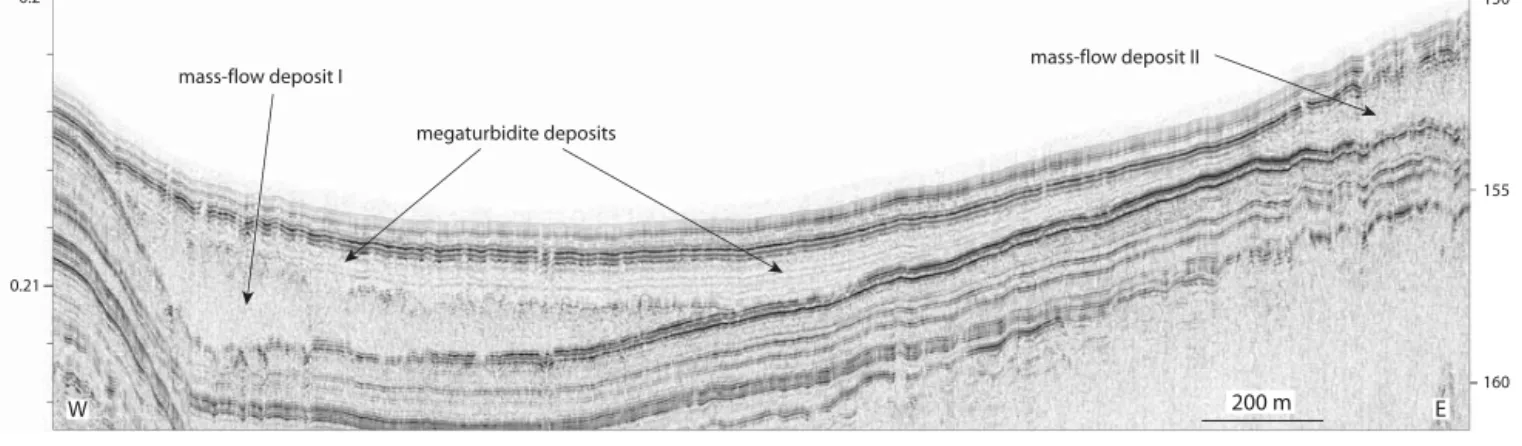
tw o-wa y tr a v eltime (s) 0.17 0.15 0.16 0.19 0.18 0.12 0.11 0.14 0.13 water depth (m) 140 130 120 110 100 90 80 mass-flow deposit II mass-flow deposit IIImass-flow deposit I rockfall cone 0.2 0.21 tw o-wa y tr a v eltime (s) water depth (m) 150 155 100 m N S
A
mass-flow deposits rockfall cone Megaturbidite deposits: homogeneous mud with graded, sandy to silty base Mass-flow deposits: limestone-fragments in muddy matrix undisturbed block: faintly laminated mud deformed sand layer undisturbed sediment: faintly laminated mud7.4 7.5 7.6 7.7 7.8 7.3 7.9
C
depth in c o re (m) sedimentto the deformation front, it is sometimes possible to recognize thrusted blocks of acoustically layered basin-plain sediment (Fig. 2A). The deep-reaching deformation of the marginal basin fill is regarded as the result of an adjustment of the basin-plain sediments to the increased static and dynamic load-ing durload-ing mass-flow deposition (Schnellmann et al. 2005).
Failure scars reaching heights >6 m have been identified on many seismic profiles throughout the study area, most of them on steepening-downwards slopes with 10–20° inclination. In most cases, the whole acoustically-lavered drape is removed below fresh slide scars and the acoustic bedrock is exposed. As no attempts have been made in this study to core the glide plane, it remains unclear whether the acoustic bedrock repre-sents glacial sediments or molasse. However, in some cases, a thin layer of sediments with a high-amplitude chaotic-to-trans-parent seismic facies overlies the acoustic bedrock (Fig. 2B). Here the glide plain most likely consists of glacial deposits.
Many of the mass-flow deposits in the basin plain can be related to failure scars on the slope above and are therefore re-garded as slide-evolved. Coring of such slide-evolved mass-flow deposits revealed deformed lake sediment. In the upper part, the sediment is heavily deformed and builds up a matrix-supported mud-clast conglomerate. In the lower part, defor-mation is much more localized and larger pieces of internally undeformed lake strata occur (Fig. 2C).
Other mass-flow deposits relate to rockfall cones (Fig. 3), which appear at the foot of steep cliffs and building up positive reliefs with irregular hummocky top surfaces. The cones are generally not penetrated by the high-resolution seismic signal. In the superfical part discontinuous high-amplitude reflections and diffractions are abundant and probably relate to blocky rock debris. At the foot of such cones, wedge-shaped mass-flow deposits with basinwards smoothing top surface and a chaotic- to high-amplitude chaotic seismic facies occur. The 1964 event produced a relatively small rockfall cone with a sin-gle mass-flow deposit (Fig. 3A). Figure 3B shows a consider-ably larger rockfall cone associated with three mass-flow de-posits at different stratigraphic levels, indicating repeated
rockfall activity at the same location. The two lower deposits (labeled mass-flow deposits I & II in Fig. 3B) are characterized by a high-amplitude-chaotic seismic facies, a common feature of large rockfall-evolved mass-flow deposits. The uppermost deposit (mass-flow deposit III) is of little extent and thickness and shows a chaotic-to-transparent rather than a high-ampli-tude-chaotic seismic facies. This relatively small deposit may result from the sliding of lake sediment deposited on the slopes of the rockfall cone and is, therefore, not necessarily related to a rockfall event. Cores through rockfall-evolved deposits re-vealed a breccia of mud clasts and angular limestone fragments (Fig. 3C). Such rock fragments are most probably the reason for the higher amplitude of the seismic facies of rockfall-evolved compared to slide-rockfall-evolved mass-flow deposits.
5.2 Megaturbidites
The mass-flow deposits are often directly overlain by a second, clearly different type of mass-movement deposits, which is characterized by a ponding geometry, an almost transparent seismic facies, a smooth top surface and maximum thicknesses reaching ~2 m. This geometry and acoustic signature is typical for thick, extensive turbidite deposits, which generally result from large mass flows (Bouma 1987).
Figure 2C shows a core through a complex turbidite related to the 1601 A.D. earthquake. It directly overlies a mass-flow deposit and is characterized by a multiple-graded sandy base, a 10 cm thick central part consisting of homogeneous medium gray mud and a light gray top. This complex turbidite is inter-preted as result of multiple sliding and related cyclic water movements in 1601 A.D. Turbidites related to rockfalls gener-ally show a particularly thick sandy base (Fig. 3C), which thins out to thin sand or silt layers towards more distal positions.
Although turbidites associate to most of the larger mass-flows in the study area, many of them are too small to be re-solved on seismic sections. Only the turbidite beds with bed thickness >15–20 cm could be mapped out in this study. In the following, we use the term “megaturbidite” for such ‘map-Fig. 4. Megaturbidite in Vitznau Basin directly overlaying two coeval mass-flow deposits. Note the characteristic, almost transparent seismic facies and the pond-ing geometry of the megaturbidite. See Figure 1B for location of the seismic line.
water depth (m) 150 155 160 200 m E W 0.2 0.21 tw o-wa y tr a v eltime (s) megaturbidite deposits mass-flow deposit I mass-flow deposit II
pable’ turbidites, which generally relate to major mass move-ments and the potentially related tsunami and seiche waves.
A somewhat untypical megaturbidite is outlined in yellow colors in Figure 5. Its thickness of up to 6 m is exceptional and, compared to all other identified megaturbidites, its seismic fa-cies is less transparent and includes short-range continuous re-flections. Nevertheless, it shows a ponding geometry. A core (core 4WS02-1), which, according to the seismic-to-core corre-lation, did not quite reach the base of these deposits, revealed a more than 1.3 m-thick, fining upward unit overlain by 40 cm of ungraded, homogeneous sediment. The possible origins of this unusual turbidite will be discussed in chapter 7.3.
6. Catalogue of Past Mass-Movement Deposits 6.1. Seismic stratigrapic mapping of event horizons
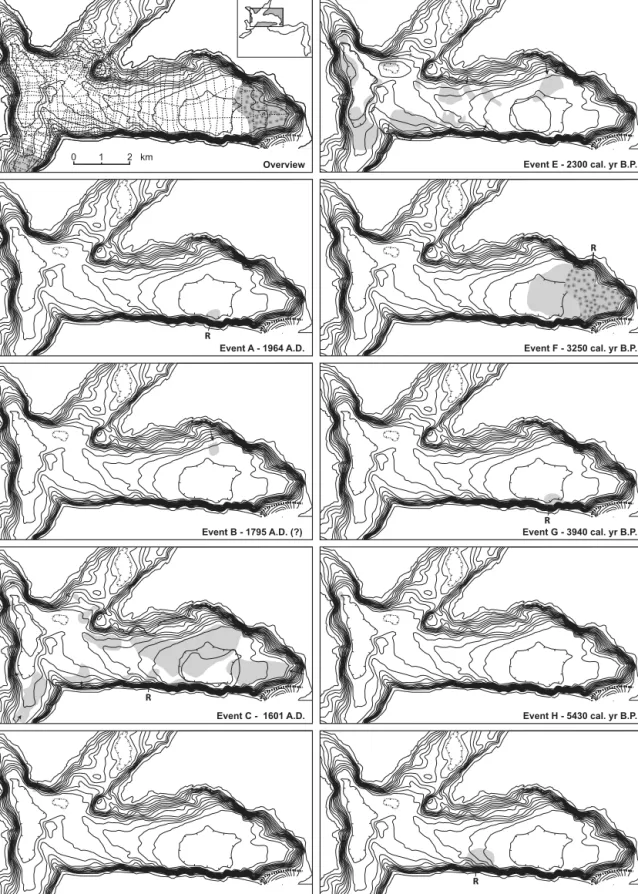
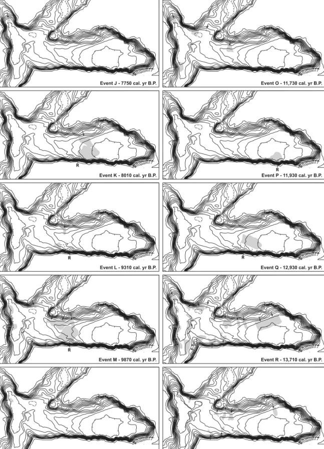
With the help of a dense grid of more than 300 km high-resolu-tion seismic lines, we identified and mapped out 91 mass-flow
deposits and 6 megaturbidites (Figs 5, 6). For establishing a chronology of past mass movements, the top of each mass-flow and megaturbidite deposit was determined and tied to a specif-ic seismspecif-ic stratigraphspecif-ic horizon (Fig. 5). The exact seismspecif-ic stratigraphic position of a mass-movement deposit can best be determined at the toe or pinch-out point of a deposit. In the in-ternal part of mass-flow deposits it is often difficult to clearly identify the top due to the presence of hummocky mass-flow surfaces. The seismic stratigraphic horizons related to specific mass-movement deposits were mapped throughout the lake, in order to recognize synchronous deposits and to allocate them to the same “event horizon” (= seismic stratigraphic horizon related to at least one mass-movement deposit).
In this way, 19 individual event horizons were identified and labeled as Event A (young) to Event S (old) according to stratigraphy. The distribution of mass-movement deposits re-lated to each of the event horizons are shown in Figure 6. Each of the event horizons comprises between 1 and 19 mass-flow and megaturbidite deposits.
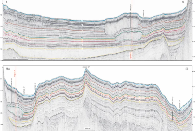
Fig. 5. Mapping of event horizons. A and B show two composite seismic lines across the western part of the study area. See Figure 1B for location of the seismic pro-files. The crossing between the two lines is indicated by solid vertical red lines. Different-colored solid lines mark seismic stratigraphic horizons relating to the top of mass-flow deposits and megaturbidites. Note that some horizons lie directly on top of more than one mass-flow deposit indicating synchronous deposition. Dashed colored lines mark the base of megaturbites, mass-flow deposits and deformed basin-plain sediment. Coring sites are indicated with bold vertical black lines.
4WS00-8P 4WS00-5P C M M N N O O H H R R S S E E F igur e A 4WS00-3P 4WS00-2P 4WS00-1P 4WS00-4P 500 m NW SE B 0.15 0.14 water depth (m) 110 100 120 130 0.16 0.17 0.18 tw o-wa y tr a v eltime (s) B C M M N N O O H H R R S S E E F igur e B 4WS02-1 4WS00-3P 500 m S N water depth (m) 110 120 130 140 0.17 0.18 0.19 0.15 0.16 tw o-wa y tr a v eltime (s) A
Fig. 6. Catalogue of mass-movement deposits in the subsurface of Lake Lucerne. The upper left panel shows the seismic survey grid, which was used for mapping and correlating the mass-movement deposits. The other panels show the areal distribution of events A to S. Zones with limited seismic penetration are indicated by dotted surfaces. Gray and hatched surfaces mark mass-flow deposits and megaturbidites, respectively. Bold solid lines delineate slide scars. Mass-flow deposits interpreted as rockfall-evolved are indicated by “R”. For dating procedure and age ranges, see Tables 1 and 2.
Event I - 6370 cal. yr B.P. R Event H - 5430 cal. yr B.P. Event G - 3940 cal. yr B.P. R Event F - 3250 cal. yr B.P. R Event E - 2300 cal. yr B.P. Event D - 1790 cal. yr B.P. Event C - 1601 A.D. R Event B - 1795 A.D. (?) Event A - 1964 A.D. R 2 km 1 0 Overview
Fig. 6. part 2 Event S - 14,590 cal. yr B.P. ? Event R - 13,710 cal. yr B.P. ? ? Event Q - 12,930 cal. yr B.P. R Event P - 11,930 cal. yr B.P. R Event O - 11,730 cal. yr B.P. ? Event N - 10,860 cal. yr B.P. K Event M - 9870 cal. yr B.P. R ? Event L - 9310 cal. yr B.P. R Event K - 8010 cal. yr B.P. R Event J - 7750 cal. yr B.P.
N L Correlation based on seismic stratigraphy C C E E MB1 MB1 M VKT M VKT R LST Correlation based on seismic stratigraphy S D H J 1.8 1.6 1.4 1.2 Density (g/cm3) 2.4 2.2 2.0 Lithology 9500 ± 80 BP ? top and base of disturbed zone unclear VKT 5 4 2 1 0 10 9 8 7 6 LS T 9400 ± 80 BP 4WS 02-1 Lithology LS T VKT 7 5 4 3 1 0 1.6 1.4 1.2 Density (g/cm3) 9785 ± 80 BP 4WS 00-4P 10 12 14 16 18 8 6 Magn. S usc. (S I) 8 9 7 6 5 4 3 2 1 0 Lithology 6755 ± 65 BP 1845 ± 50 BP 1.6 1.4 1.2 Density (g/cm3) 4WS 00-3P 8 9 7 6 5 4 3 2 1 0 2230 ± 60 BP Lithology 1.6 1.4 1.2 Density (g/cm3) 4WS 00-2P Lithology 8480 ± 65 BP 8095 ± 85 BP 8335 ± 70 BP 7380 ± 70 BP 2440 ± 50 BP 4400 ± 55 BP 2100 ± 50 BP 6150 ± 65 BP 1.6 1.4 1.2 Density (g/cm3) 8 5 3 2 1 0 4WS 00-1P VKT
C
2 km 1 0 NA
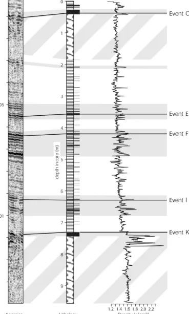
4WS00-6P 4WS00-7P 4WS02-2 4WS00-5P 4WS00-8P 4WS00-4P 4WS02-1 4WS00-3P4WS00-2P 4WS00-1PFig. 7. Core-to-core correlation along an E-W transect. A. Location of coring sites. B. Cross section across the study area with coring sites indicated by vertical black bars. C. Core-to-core correlation based on lithology, density and magnetic susceptibility. Solid lines delineate core-to-core correlation of mass-movement hori-zons and other marker beds. Uncertain correlations are indicated with dashed lines. Dotted horizontal lines show the litho-stratigraphic positions of event horihori-zons, which did not leave characteristic deposits like deformed beds or turbidites in the available cores. The lithostratigraphic positions of such events are solely based on seismic-to-core correlation (see text for further explanation). Note the two peaks in the magnetic susceptibility log of core 4WS00-4P at 5.75 m and 7.52 m, which re-late to the Vasset Killian (VKT) and to the Laacher See Tephra (LST), respectively. Markerbed MB1 represents a characteristic sequence of closely spaced tur-bidites, which was used for core-to-core correlation.
Fig. 7. part 2 I F F L K K C C E E M MB1 VKT R S LST MB1 O P Q G 3 1 1.8 1.6 Density (g/cm3) 2.0 Lithology LS T 4WS 02-2 12,095 ± 115 BP Lithology 8860 ± 70 BP VKT 4 2 1 0 4WS 00-8P 1.8 1.6 1.4 1.2 Density (g/cm3) 5985 ± 65 BP 10,690 ± 80 BP 11,440 ± 140 BPLS T 11,140 ± 80 BP Lithology 1.6 1.4 1.8 2.02.2 1.2 Density (g/cm3) 8 7 6 4 3 2 1 0 9 7040 ± 70 BP 3550 ± 55 BP 3775 ± 55 BP 5940 ± 60 BP 6170 ± 60 BP 4WS 00-7P 5550 ± 65 BP 8 7 6 5 4 3 2 1 0 9 10 Lithology 1.6 1.4 1.82.0 1.2 Density (g/cm3) 2180 ± 50 BP 2985 ± 50 BP 6920 ± 65 BP 4WS 00-6P Lithology 8 5 4 3 2 1 0 1.6 1.4 1.2 Density (g/cm3) 8890 ± 75 BPVKT 4WS 00-5P 468 10 12 Magn. S usc.(S I)
faintly laminated gray mud with intercalated turbidites (indicated by black bars) and frequent organic material laminated medium to light gray mud with intercalated turbidites (indicated by black bars) and little organic material very thinly laminated light gray to yellowish mud with frequent intercalated turbidites (indicated by black bars) deformed sediment beds comprising highly reworked mud clast conglomerates as well as
larger blocks of internally undisturbed blocks of lacustrine strata
150 m 200 m 100 m 2 km 1 0 E W ? 1P 4P 7P 6P lake floor 2P 02-1 02-2 3P 8P 5P base Holocene
base of sediments with a regular and continuous acoustic layering
Chrüztrichter Basin Vitznau Basin
Fig. 8. Seismic-to-core correlation (Core 4WS00-7P; for position see Fig. 7A). Gray bars highlight the correlation between high-reflective zones in the seis-mic data, high turbidite frequency and distinct changes of the gamma-ray den-sity. Hatched zones indicate acoustically chaotic-to-transparent areas on the seismic profile and corresponding deformation intervals in the sediment core. Solid lines delineate the correlation between seismic stratigraphic event hori-zons and specific lithological beds.
Seismics 0.00 0.005 0.01 tw o -w a y tr a v e lti m e ( s) Event C Event E Event F Event I Event K 1.6 1.4 1.82.02.2 1.2 Density (g/cm3) Lithology 8 7 6 5 4 3 2 1 0 9 de pt h in co re ( m )
The catalogue of past mass-movement activity shown in Figure 6 is not complete because: (1) only the youngest de-posits were mapped out in the very eastern part of Vitznau Basin and in the southern part of Chrüztrichter Basin due to limited penetration of the seismic signal, (2) relatively small and/or old mass-movement deposits may not have been recog-nized due to reworking and deformation by younger and larger events, and (3) some, mostly small, mass-movement deposits could not be included in the mass-movement event catalogue due to the lack of clear tops or pinch out points.
6.2. Coring of the event horizons
To date the prehistoric event horizons, 10 sediment cores reaching subsurface depths up to 20 m were retrieved from key locations, which were chosen based on the seismic data (Figs 5, 7A, B). Mass-flow and megaturbidite deposits related to the most prominent event horizons (Fig. 6 – Events C, E, M, R, S) were cored in both, the Chrüztrichter and Vitznau Basins in order to accurately date these deposits and to check the syn-chronicity of mass-flow deposits relating to specific seismic stratigraphic event horizons by core-to-core correlation. To allow accurate correlation and to overcome changing sedimen-tary characteristics between Vitznau and Chrüztrichter Basins, the coring sites were chosen along an E-W transect and the maximum distance between different coring sites was kept small (Figs 7A, B). In cores, the limits between mass-flow de-posits and autochthonous sediment are difficult to identify, as transported blocks of former strata often remain internally undisturbed (Schnellmann et al. 2005). Hence, along with cores through mass-flow deposits, cores from nearby undis-turbed sites were retrieved. Correlation between the two cores generally allowed identification of top and base of the mass-flow deposits.
Comparison of the seismic reflection patterns with litho-logical and gamma-ray density logs of the cores enables an ac-curate seismic-to-core correlation (Fig. 8). Reflection patterns characterized by high-amplitude reflections were matched with pronounced density changes, which typically relate to coarse and dense turbidite beds. Zones with a chaotic-to-transparent seismic facies were correlated to deformed sediment beds. For the majority of the seismic stratigraphic event horizons (Fig. 6 – Events C, E, F, I, K, L, M, N, R, S), the exact litho-strati-graphic position could be determined due to characteristic lay-ers, such as deformed deposits, (mega)turbidite beds or sand layers. Other events identified on the seismic data, however, did not leave direct traces at the coring sites. The litho-strati-graphic positions of such event horizons (Fig. 6 – Events D, G, H, J, O, P, Q) have been determined from their relative posi-tion between two known event horizons.
Correlation between neighboring cores was achieved by comparing both petrophysical properties and visual character-istics (Fig. 7C). In this way, and because of the relatively small maximum distance between the coring sites, a good core-to-core correlation was established. The following marker beds were traced throughout the basins and coring sites: (1) the mass-flow and (mega)turbidite beds related to Event E, (2) a characteristic sequence of closely spaced turbidite deposits (MB1), (3) The Boreal Vasset-Killian Tephra (VKT), (4) the mass-flow and turbidite beds related to Event M, and (5) the Allerød Laacher See Tephra (LST). The VKT and LST Tephras origin from volcanic eruptions in the Massive Central, Central France, and the Eifel, Western Germany, respectively. Both tephra-layers have been identified in several lakes in Switzerland (Hajdas et al. 1993; Shotyk et al. 1998) and SW-Germany (Merkt 1971; Mayer & Schwark 1999) and show
dis-tinct peaks in the magnetic susceptibility curves of several Lake Lucerne cores (see core 4WS00-4P in Fig.7 for a typical example). For sediments older than the lower tephra layer, correlation between the basinal core 4WS02-1 and the cores 4WS00-4P and 4WS02-2, which were retrieved further away from the depocenters, could not be established. This is most probably due to the enhanced focusing of Late Glacial sedi-mentation in the basin centers, which results in large differ-ences in both, sedimentation rates and sediment characteristics from basinal to more elevated environments.
6.3. Dating of the event horizons
The three youngest event horizons (Fig. 6 – Events A, B, C) all occurred in historical times. Events A and C have already been
identified and dated in earlier studies and relate to the 1964 A.D. Obermatt rockfall and the 1601 A.D. earthquake, respec-tively (Siegenthaler et al. 1987; Lemcke 1992). Event horizon B lies stratigraphically between these two events and compris-es only a single mass-flow deposit, which is located offshore the village of Weggis. Based on high-resolution seismics and core analysis, Zwyer (2006) showed that this deposid results from a subaqueous continuation of the 1795 A.D. Rubi lands-lide.
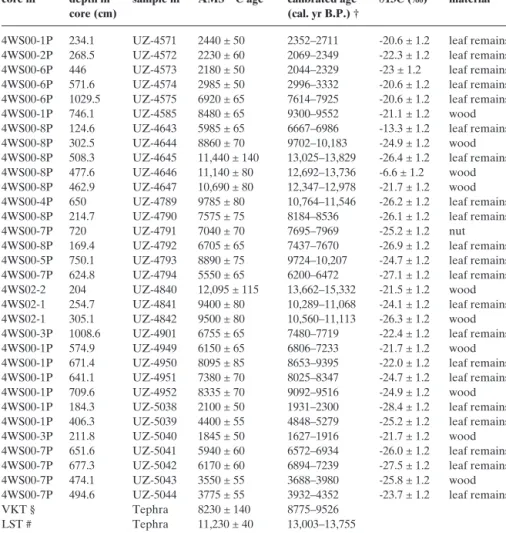
Thirty-two samples from various depths and cores were collected for AMS-radiocarbon dating (Table 1). To minimize the risk of dating reworked samples, terrestrial leaf remains were the preferred sample material. However, particularly in Late Glacial deposits, where organic material is scarce, small fragments of wood were also used for dating. Further age con-core nr depth in sample nr AMS 14C age * calibrated age ∂13C (‰) material
core (cm) (cal. yr B.P.) †
4WS00-1P 234.1 UZ-4571 2440 ± 50 2352–2711 -20.6 ± 1.2 leaf remains
4WS00-2P 268.5 UZ-4572 2230 ± 60 2069–2349 -22.3 ± 1.2 leaf remains
4WS00-6P 446 UZ-4573 2180 ± 50 2044–2329 -23 ± 1.2 leaf remains
4WS00-6P 571.6 UZ-4574 2985 ± 50 2996–3332 -20.6 ± 1.2 leaf remains
4WS00-6P 1029.5 UZ-4575 6920 ± 65 7614–7925 -20.6 ± 1.2 leaf remains
4WS00-1P 746.1 UZ-4585 8480 ± 65 9300–9552 -21.1 ± 1.2 wood
4WS00-8P 124.6 UZ-4643 5985 ± 65 6667–6986 -13.3 ± 1.2 leaf remains
4WS00-8P 302.5 UZ-4644 8860 ± 70 9702–10,183 -24.9 ± 1.2 wood
4WS00-8P 508.3 UZ-4645 11,440 ± 140 13,025–13,829 -26.4 ± 1.2 leaf remains
4WS00-8P 477.6 UZ-4646 11,140 ± 80 12,692–13,736 -6.6 ± 1.2 wood
4WS00-8P 462.9 UZ-4647 10,690 ± 80 12,347–12,978 -21.7 ± 1.2 wood
4WS00-4P 650 UZ-4789 9785 ± 80 10,764–11,546 -26.2 ± 1.2 leaf remains
4WS00-8P 214.7 UZ-4790 7575 ± 75 8184–8536 -26.1 ± 1.2 leaf remains
4WS00-7P 720 UZ-4791 7040 ± 70 7695–7969 -25.2 ± 1.2 nut
4WS00-8P 169.4 UZ-4792 6705 ± 65 7437–7670 -26.9 ± 1.2 leaf remains
4WS00-5P 750.1 UZ-4793 8890 ± 75 9724–10,207 -24.7 ± 1.2 leaf remains
4WS00-7P 624.8 UZ-4794 5550 ± 65 6200–6472 -27.1 ± 1.2 leaf remains
4WS02-2 204 UZ-4840 12,095 ± 115 13,662–15,332 -21.5 ± 1.2 wood
4WS02-1 254.7 UZ-4841 9400 ± 80 10,289–11,068 -24.1 ± 1.2 leaf remains
4WS02-1 305.1 UZ-4842 9500 ± 80 10,560–11,113 -26.3 ± 1.2 wood
4WS00-3P 1008.6 UZ-4901 6755 ± 65 7480–7719 -22.4 ± 1.2 leaf remains
4WS00-1P 574.9 UZ-4949 6150 ± 65 6806–7233 -21.7 ± 1.2 wood
4WS00-1P 671.4 UZ-4950 8095 ± 85 8653–9395 -22.0 ± 1.2 leaf remains
4WS00-1P 641.1 UZ-4951 7380 ± 70 8025–8347 -24.7 ± 1.2 leaf remains
4WS00-1P 709.6 UZ-4952 8335 ± 70 9092–9516 -24.9 ± 1.2 wood
4WS00-1P 184.3 UZ-5038 2100 ± 50 1931–2300 -28.4 ± 1.2 leaf remains
4WS00-1P 406.3 UZ-5039 4400 ± 55 4848–5279 -25.2 ± 1.2 leaf remains
4WS00-3P 211.8 UZ-5040 1845 ± 50 1627–1916 -21.7 ± 1.2 wood
4WS00-7P 651.6 UZ-5041 5940 ± 60 6572–6934 -26.0 ± 1.2 leaf remains
4WS00-7P 677.3 UZ-5042 6170 ± 60 6894–7239 -27.5 ± 1.2 leaf remains
4WS00-7P 474.1 UZ-5043 3550 ± 55 3688–3980 -25.8 ± 1.2 wood
4WS00-7P 494.6 UZ-5044 3775 ± 55 3932–4352 -23.7 ± 1.2 leaf remains
VKT § Tephra 8230 ± 140 8775–9526
LST # Tephra 11,230 ± 40 13,003–13,755
* Preparation and pretreatment of sample material for radiocarbon dating was carried out by the 14C
laboratory of the Department of Geography at the University of Zurich (GIUZ). The dating itself was done by AMS (accelerator mass spectrometry) with the tandem accelerator of the Institute of Particle Physics at ETH Zurich. † Calibration (2 sigma range) was carried out with CALIB 4.4 software (Stuiver and Reimer, 1993). § Vasset Killian Tephra (VKT), radiocarbon dated by Hajdas et al. (1993). # Laacher See Tephra (LST), radiocarbon dated by Hajdas et al. (1995).
straints arose from the two tephra layers, which have been ra-diocarbon dated to 8230 ± 140 B.P. (VKT; Hajdas et al. 1993)
and 11,230 ± 40 14C yrs B.P. (LST; Hajdas et al. 1995) in
Sop-pensee, a small lake 20 km SW of Lucerne.
The 14C-ages were transferred to calendar years (2s-range)
with the Calib 4.3 software (Table 1; Stuiver & Reimer 1993). For dating an individual event horizon the
lithostratigraphi-cally closest 1-4 14C-ages were selected. The error introduced
by the offset between the lithostratigraphic position of 14
C-age and event horizon was corrected using the estimated sedi-mentation rates applied to the sample-horizon offset (Table 2). In this way, for each of the 1-4 selected samples, an age range for the event horizon was calculated. Subsequently, the overlap of the obtained age-ranges and its center was deter-mined. The same procedure was repeated for each of the event horizons.
7. Spatial and Temporal Distribution of Past Mass-Movement Activity
7.1. Subaqueous sliding
In order to identify subaqueous slopes, which are particularly susceptible to sliding, all failure scars and all non-rockfall evolved mass-flow deposits were superpositioned (Fig. 9A). The identified scars occur on steepening-downward sections of marginal slopes or subaqueous hills with at least partial incli-nations >10° (Fig. 9). Stacked mass-flow deposits at the foot of slopes with distinct slide scars indicate repeated sliding on the same slope.
The surface covered by individual mass-flow deposits
ranges from <0.01 km2to >6 km2. Transported volumes are
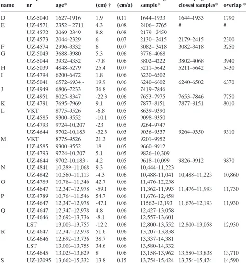
difficult to calculate, as slope material and reworked basin-horizon sample calibrated offset sed.rate horizon age overlap age of center of name nr age* (cm) † (cm/a) sample* closest samples* overlap *§
D UZ-5040 1627–1916 1.9 0.11 1644–1933 1644–1933 1790 E UZ-4571 2352 – 2711 4.3 0.08 2406– 2765 # # UZ-4572 2069–2349 8.8 0.08 2179– 2459 UZ-4573 2044–2329 6 0.07 2130– 2415 2179–2415 2300 F UZ-4574 2996–3332 6 0.07 3082– 3418 3082–3418 3250 G UZ-5043 3688–3980 5.3 0.06 3776–4068 UZ-5044 3932–4352 -7.8 0.06 3802–4222 3802–4068 3940 H UZ-5039 4848–5279 25.4 0.07 5211–5642 5211–5642 5430 I UZ-4794 6200–6472 1.8 0.06 6230–6502 UZ-5041 6572–6934 - 19.9 0.06 6240–6602 6240–6502 6370 J UZ-4949 6806–7233 36.8 0.06 7419–7846 UZ-4951 8025–8347 -22.3 0.06 7653–7975 7653–7846 7750 K UZ-4791 7695–7969 9.1 0.05 7877–8151 7877–8151 8010 L VKT 8775–9526 -6.8 0.05 8639–9390 UZ-4585 9300–9552 -10.1 0.05 9098–9350 UZ-4793 9724–10,207 -23 0.05 9264–9747 UZ-4644 9702–10,183 -32.3 0.05 9056–9537 9264–9350 9310 M VKT 8775–9526 21.3 0.05 9201–9952 UZ-4585 9300–9552 18 0.05 9660–9912 UZ-4793 9724–10,207 5.1 0.05 9826–10,309 UZ-4644 9702–10,183 - 4.2 0.05 9618–10,099 9826–9912 9870 N UZ-4841 10,289–11,068 9.3 0.06 10,444–11,223 UZ-4842 10,560–11,113 -4.3 0.06 10,488–11,041 10,488–11,223 10,860 O UZ-4789 10,764–11,546 42.7 0.06 11,476–12,258 UZ-4647 12,347–12,978 -59.1 0.06 11,362–11,993 11,476–11,993 11,730 P UZ-4789 10,764–11,546 54.7 0.06 11,676–12,458 UZ-4647 12,347–12,978 -47.1 0.06 11562–12,193 11,676–12,193 11,930 Q UZ-4647 12,347–12,978 4.8 0.06 12,427–13,058 UZ-4646 12,692–13,736 -8.1 0.06 12,557–13,601 LST 13,003–13,755 -12.2 0.06 12,800–13,552 12,800–13,058 12,930 R UZ-4647 12,347–12,978 51.6 0.06 13,207–13,838 UZ-4646 12,692–13,736 38.7 0.06 13,337–14,381 LST 13,003–13,755 34.6 0.06 13,580–14,332 UZ-4645 13,025–13,829 8 0.06 13,158–13,962 13,580–13,838 13,710 S UZ-12095 13,662–15,332 13.8 0.15 13,754–15,424 13,754–15,424 14,590
* Ages in cal. yr B.P. † Position of the dated sample relative to the event horizon. § Ages are rounded to the decade. # Sample UZ-4571 is not included in the determination of the horizon age due to its anomalous age range (reworking?)
plain sediment often cannot be distinguished on seismic sec-tions. Estimates of the volume transported by the two biggest
mass-flow deposits revealed more than 10 million m3. The
ma-jority of the thick and extensive non-rockfall-evolved mass-flow deposits occur at the foot of slopes with inclinations of 10–20°, while only a few small mass-flow deposits are present below slopes steeper than 25° (Fig. 9). It seems that slopes with inclinations <10° are essentially stable and slopes with inclina-tions >25° are too steep to accumulate the sediment volumes needed for major sliding. The “Weggis Slide”, one of the largest events in the study area (Fig. 6 – Event C), was trig-gered in an area with slope inclinations >10° before eroding flatter zones along its path. Once a slide is initiated, it is thus capable of eroding flatter slopes and thereby gaining volume.
Whereas the slide locations remain more or less the same from Late Glacial to Holocene times, the size of the Late Holocene mass-flow deposits tends to be larger compared to their older counterparts (Fig. 6). This is interpreted as a result of limited sediment deposition on the subaqueous slopes in Late Glacial times due to underflow-dominated sedimentation and limited productivity.
7.2. Rockfalls
Rockfall deposits occur along three zones in the southern and in the northeastern parts of Vitznau Basin. The location of the three rockfall cones and the corresponding number of rock-fall-incidents (number of rockfall-evolved mass-flow deposits) is indicated for each of the three locations in Figure 9A. These are minimum numbers, as rockfall events can heavily rework the basin-plain sediment and thereby destroy traces of older events. In the rockfall zone on the northern shore of Vitznau basin, the lake sediments older than the major rockfall Event F (3250 cal. yr B.P.) cannot be imaged with the seismic data due to reworking and gas-blanking.
Our data indicate a higher rockfall activity at the northern face of Bürgenstock before 6000 cal. yr B.P. Later, both the number of rockfall events and the size of rockfall-evolved mass-flow deposits decreased. There is no indication of a per-sistent migration of the instable zone and the related rockfall activity along the cliff of Bürgenstock Mountain.
As the southern shore of the Vitznau Basin is scarcely pop-ulated, the major hazard related to such events arises from rockfall-induced waves. Such waves particularly affect the northern shore of Vitznau Basin, as observed during the 1964 A.D. Obermatt rockfall. Most of the prehistoric rockfalls iden-tified in this study included larger volumes than this event. As the height of rockfall-generated waves is largely related to the volume of the displaced mass (Huber 1980; Vischer 1986), the waves generated by some of the prehistoric events may have been considerably larger than the historical example. However, the generation of waves by rockfalls is complex, and the shape and height of such waves also depend on many other parame-ters, such as shape and air content of the impacting mass, path-way-inclination and height of fall (Huber 1980; Fritz 2002).
7.3. Megaturbidites
The late Holocene multiple mass-movement events (Fig. 6; Events C, E) are associated with large megaturbidites. Minor turbidites have also been identified in relation to other events (Fig. 7 – Events F, I, K, L, M, N, R). However, due to their small size, these minor turbidites can not be seen on seismic sections, but only in cores. The following factors may be re-sponsible for the high amount of resuspension and the build-up of thick megaturbidites related to the Events C and E: (1) the relatively large size and number of involved mass flows, (2) the existence and considerable size of slide-induced tsuna-mi and seiche waves (Siegenthaler et al. 1987; Schnellmann et al. 2002), which potentially resuspend sediments from the lake floor (Siegenthaler et al. 1987; Chapron et al. 1999) and (3) the presumably high remobilization potential of the Late Holocene sediment.
As outlined in chapter 5.2, the large megaturbidite associ-ated with Event S shows a seismic facies, which is less trans-parent and includes short-range continuous reflections. Al-though the base of the megaturbidite has not been reached, the coring indicates a much thicker graded sequence (Fig. 7 – core 4WS02-1) and a higher sand content compared to the other megaturbidites observed in this study. The lateral thick-ness distribution of the event indicates transport from the re-gion of Stansstaad, where a paleodelta indicates a temporal drainage of Engelberger Aa River towards Chrüztrichter basin (Fig. 1). Transport direction and lateral sediment distribution could be explained by a delta collapse. Alternatively a cata-strophic flooding in the catchment, possibly related to the out-burst of an ice-, moraine- or rockfall-dammed lake could be the reason for the exceptional megaturbidite. Such a process has been proposed for two exceptional graded layers in Lake Constance, which have been linked to the outburst of two lakes produced by the Flims and Tamins Rockfalls, respective-ly (Schneider et. al. 2004).
8. Trigger Mechanism
One of the most remarkable characteristics of the mass-flow deposits in the subsurface of Lake Lucerne is the occurrence of several horizons with multiple coeval mass-flow and megatur-bidite deposits (Figs 7, 10). Seventy-five of the total 91 mapped mass-flow deposits relate to 6 multiple mass-movement hori-zons showing that regional trigger mechanisms are important. Multiple mass movement deposits have been shown to be a common geological signature of strong historic earthquakes, both in subaerial (Keefer 2002; Becker & Davenport 2003; Harp et al. 2003) and subaqueous environments (Locat et al. 2003; Skinner & Bornhold 2003). In Lake Lucerne, the youngest multiple mass-movement horizon (Event C) relates
to the 1601 A.D. Mw~ 6.2 earthquake and comprises 13 coeval
mass-flow deposits, which are overlain by two megaturbidites in the center of the Chrüztrichter and Vitznau basins. Distinct, more than 6 m-high failure scars on the subaqueous slopes
point towards subaqueous sliding as the dominant primary mass-movement process. One of the 1601 A.D. mass-flow de-posits directly lies at the foot of a rockfall cone and is, there-fore, interpreted as rockfall-evolved. Historical data, indeed, describe a rockfall on Bürgenstock Mountain, which caused a wave in the Vitznau Basin (Cysat 1969; Schwarz-Zanetti et al. 2003). The location of the identified rockfall deposit fits well to a locality named “an der Risi” (in English: at the place of the rockfall) on a detailed map of Lake Lucerne from 1645 A.D. (Cysat 1645).
Historic Event C shows the typical signature of a strong earthquake in Lake Lucerne and points towards a high suscep-tibility of the subaqueous slopes to multiple earthquake-in-duced sliding (Figs 7; 10). Prehistoric multiple mass-movement horizons in Lake Lucerne are, therefore, likely to be the prod-uct of strong seismic shocks as well and can be used to recon-struct the prehistoric earthquake history. Prehistoric Events E, M, O, R and S each comprise seven or more coeval mass-flow deposits and are, thus, interpreted as the result of strong
earth-quake shaking (Figs 7, 10). In contrast, mass-flow deposits lacking more than one coeval counterpart are regarded as trig-gered either by an aseismic process or by a minor seismic shock. Strong earthquakes can be excluded as trigger mecha-nism as they would destabilize multiple slopes at the same time.
For testing the earthquake triggering hypothesis, we further analyzed the multiple mass-movement horizons and tried to systematically exclude possible non-earthquake triggers, i.e. overloading and oversteepening of subaqueous slopes, regional flood events, loading by wind-induced surface waves and lake level variations. Overloading or oversteepening of different slopes of various orientation and water depths are unlikely to occur synchronously, particularly in the studied basins, which are characterized by low fluvial input. Flood events may trigger subaerial landslides, subaerial debris flows and hyperpycnal flows within a short time period all around the lake. Although such subaerial events may reach the lake and are capable of eroding submerged slopes along their pathway, they cannot ex-Fig. 9. A. Spatial distribution of identified slide scars, rockfall cones and mass-flow deposits. Gray shadings indicate the total number of identified mass-flow deposits at the foot of slopes with sub-aqueous failure scars. The number of rockfall-evolved mass-flow deposits related to each of the three rockfall cones is indicated next to the cones. B. Slope gradients of the studied basins as cal-culated from the seismic data. In the hatched area, the spacing of the seismic lines is insufficient for an accurate determination of the slope gradi-ent. Some artefacts also occur in the immediate proximity of the shoreline.
5 0 10 20 30 40 15 25 35 >45
B
slope gradient ( ) 2 km 1 0 2 3 4 5 1 6 number of mass-flow deposits rockfall cones withnumber of incidents failure scars 1 1
A
3 3 6plain deeply submerged scars and/or deposits at the foot of sub-aqueous hills in longer distance from the shoreline. Such fea-tures have been observed for all multiple mass-movement hori-zons with the exception of event S (Figs 6, 10). Extreme wind events may rework and destabilize the shallow zones of the lake. The maximum water depth, which may be influenced by wind-induced surface waves, can be calculated for certain fetch-es (horizontal distance over which a wave-generating wind blows) and wind velocities (Hakanson & Jansson 1983). A worst case scenario for the study area with stable wind veloci-ties of 40 m/s and an effective fetch of 5 km revealed wave am-plitudes of 1 m, wavelengths of 37 m and a wave base (l/2 wave-length) of 18.5 m. Sediment in water depths >30 m below the present lake level is, therefore, unlikely to be affected by wind
activity, even at times when the lake level was 9 m lower than today (Kopp 1938; Eberschweiler 2003). It also seems unlikely that the probably stepwise rise of lake level since mid Holocene times triggered numerous coeval slides in the deep water.
The tsunami waves associated with major rockfall or sub-aqueous slide events may erode parts of the shore and will in-duce rapid lake level changes, which will potentially initiate secondary mass flows. Events K, L and M include major rock-falls and mass-flow deposits at the foot of the slopes opposite the rockfall cliff. Out of these three horizons, a seismic trigger mechanism is only assigned to Event M, which comprises mass-flow deposits at other locations than just opposite the rockfall cliff and includes a slide scar in more than 70 m water depth.
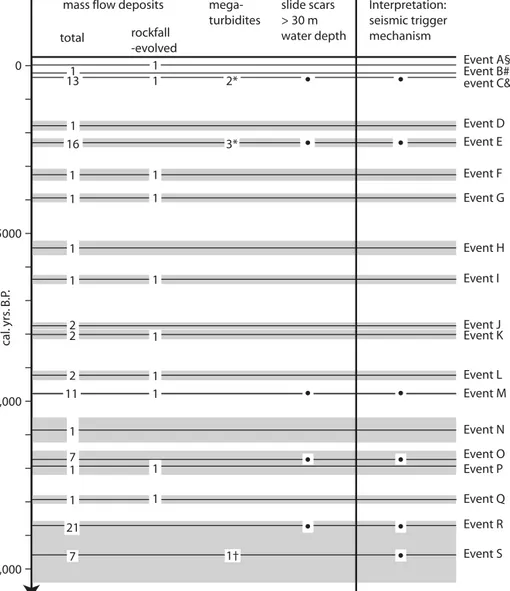
Fig. 10. Stratigraphical distribution of identified event horizons in Chrüztrichter and Vitznau Basins. Shadings indicate the error bars. Number and type of deposits, as well as the inferred trigger mechanism, are shown for each event horizon.
cal. yrs . B .P . 0 5000 10,000 15,000 Interpretation: seismic trigger mechanism rockfall -evolved total event C& Event D Event E Event F Event G Event H Event I Event J Event K Event L Event M Event S Event R Event Q Event P Event O Event N mass flow deposits
1 1 Event B# Event A§ 1 16 mega-turbidites 2* 3* 1† 1 1 1 1 1 1 1 1 1 1 2 2 7 7 2 11 1 1 1 1 1 1 1 1 1 1 slide scars > 30 m water depth 21
*Megaturbidite related to subaqueous sliding and to related tsunami/seiche waves †Megaturbidite related to major delta collapse or outburst of naturally-dammed lake §Hist. rockfall, 1964 A.D. (Huber, 1980; Lemcke, 1992)
#Continuation of hist. subaerial landslide, 1795 A.D. (Pfyffer, 1795; Zwyer, 2006)
&Hist. earthquake, 1601 A.D., Mw ~ 6.2 (Siegenthaler et. al., 1987; Schwarz-Zanetti et. al., 2003)
13
It remains unclear, whether the megaturbidite associated to event S results from a delta collapse or from the outbreak of a naturally dammed lake. Both, delta collapses and the out-break of dammed lakes can be, but don’t have to be related to earthquakes. Our assignment of a seismic trigger to event S is based on the fact that the megaturbidite correlates to 7 mass-flows in different parts of the lake.
The temporal distribution of the 6 horizons, which are in-terpreted as remnants of strong earthquakes, is highly irregular with four out of six events occurring between 9800 and 15,000 cal. yr B.P. (Fig. 10). The higher frequency before 9800 cal. yr B.P. could potentially be related to isostatic rebound after re-treat of the alpine glaciers (Stewart et al. 2000, and references therein).
The number and size of mass-flow deposits associated to an event horizon do not necessarily reflect the intensity of seismic shaking. Particularly if two earthquake shocks of similar size appear within a short period, the number and size of the mass-flow deposits related to the second shock will, most probably, be smaller. To test the results from this study and to estimate magnitudes and epicenters, it is crucial to investigate a series of archives within a region and to map out the regional distribu-tion of earthquake traces related to specific prehistoric events. The identification of mass-flow deposits and soft-sediment de-formation structures related to the 1601 A.D. earthquake in Lake Lungern, Lake Seelisberg and Lake Baldegg shows that the smaller lakes in the vicinity of Lake Lucerne are capable of recording earthquake activity (Monecke et al. 2004). Paleo-seismic investigations of prehistoric sediments in these lakes are given by Monecke et al. (2006, this volume). In a recent study three multiple mass-movement horizons have been iden-tified in Lake Zurich (Strasser et al. 2006). The age ranges of these events overlap with Events E, O and R in Lake Lucerne strengthening the hypothesis of earthquake triggering and al-lowing for estimates of magnitudes and epicenters.
9. Conclusion
(1) Combined high-resolution seismic and core studies of the subsurface of lakes enable identification and dating of stacked mass-movement deposits and allow for the determination of their type, distribution and frequency. In this way, the historic mass-movement event catalogue can be extended to prehis-toric times and low frequency events can be included in the natural hazard assessment of a region.
(2) Subaqueous slides leave failure scars on the slopes and wedge-shaped mass-flow deposits with a chaotic-to-transpar-ent seismic facies in the subjacchaotic-to-transpar-ent basin plain. Size and fre-quency of subaqueous slides largely depend on slope gradients. In the studied basins of Lake Lucerne, the most frequent and extensive deposits appear beneath slopes with moderate incli-nations of 10–20°. Slopes with incliincli-nations smaller than 10° barely failed in the past and slopes steeper than 25° seem to be too steep to accumulate enough sediment for major sliding.
(3) Rockfalls build up basin-marginal cones with
hum-mocky surfaces that are not penetrated by the seismic signal, but typically produce diffractions and some high-amplitude re-flections. Stacked mass-flow deposits at the foot of a rockfall cone point towards repeated rockfalls from the same cliff. Our data reveal a major rockfall event at the Rigi Mountain and re-peated rockfall activity along two zones of the Bürgenstock Mountain. Two historical examples indicate that the main haz-ard caused by rockfalls from the Bürgenstock cliff arises from waves induced by rockfall-impact on the lake. Most of the pre-historic deposits are larger compared to their pre-historic counter-parts and are, therefore, likely to have initiated equal or larger impact waves.
(4) Six multiple mass-movement horizons have been identi-fied, each comprising 7 or more coeval deposits. The youngest
of these events relates to the 1601 A.D. Mw~ 6.2 earthquake.
By analogy, the five older multiple mass-movement horizons are interpreted as remnants of strong prehistoric earthquakes. Four of the five prehistoric horizons include slide scars in water depths >30 m, providing further evidence for a seismic trigger mechanism, as even extreme winds or rainfall events including widespread subaerial debris-flow activity will not produce failure scars on non-delta slopes in such water depths. The temporal distribution of the multiple mass-movement horizons indicates an irregular occurrence of strong earth-quakes in the past 15,000 years, with enhanced activity during Late Glacial and early Holocene times.
Acknowledgements
We would like to thank Robert Hofmann for help during field work and Urs Gerber for the core photographs. Accommodation and harbor for field work were kindly provided by the EAWAG Limnological Research Center at Kas-tanienbaum. Arnfried Becker, Emmanuel Chapron, Stéphanie Girardclos, Ka-trin Monecke, Gabriela Schwarz and Michael Strasser are acknowledged for the numerous discussions of the data presented in this paper. Constructive re-views by Michael Sturm and Bernd Zolitschka helped to improve the manu-script. This study was supported by the Swiss National Science Foundation and the Swiss Commission for the Safety of Nuclear Installations.
REFERENCES
BECKER, A. & DAVENPORT, C.A. 2003: Rockfalls triggered by the AD 1356 Basle Earthquake. Terra Nova 15, 258–264.
BILLETER, J. 1916: Aus der Chronik des Pfarrers Jakob Billeter von Aegeri. In: XXII. Neujahrsblatt Uri, Verein für Geschichte und Altertümer von Uri, Altdorf, 43.
BLIRKA, L.H., LONGVA, O., BRAATHEN, A. & ANDA, E., DEHLS, J. & STALS
-BERG, K. in press: Rock-slope failures in Norwegian fjord areas: exam-ples, spatial distribution and temporal pattern. In: Landslides from Mas-sive Rock Slope Failure (Ed. by EVANS, S.G., SCARAWCIAMUGNOZZA, G., STROM, A.L. & HERMANNS, R.L.), Springer, Dordrecht.
BOUMA, A.H. 1987: Megaturbidite: An Acceptable Term? Geo-Marine Let-ters 7, 63–67.
BUSSMANN, F. 2006: The sediments of Lake Lauerz – a new approach to estab-lish the timing of the Rossberg landslide succession and the chronology of exceptional rainfall events. Unpublished Diploma Thesis ETH Zurich, 82 pp.
BUXTORF, A., 1916: Geologische Vierwaldstättersee-Karte 1:50 000, Schweiz-erische Geologische Kommission, Bern.
BÜNTI, J.L. 1914: Aus der Chronik des Landammann Joh. Lorenz Bünti von Stans. In: XX. Neujahrsblatt Uri, Verein für Geschichte und Altertümer von Uri, Altdorf, 8–9.