HAL Id: tel-00312752
https://tel.archives-ouvertes.fr/tel-00312752
Submitted on 26 Aug 2008HAL is a multi-disciplinary open access archive for the deposit and dissemination of sci-entific research documents, whether they are pub-lished or not. The documents may come from teaching and research institutions in France or abroad, or from public or private research centers.
L’archive ouverte pluridisciplinaire HAL, est destinée au dépôt et à la diffusion de documents scientifiques de niveau recherche, publiés ou non, émanant des établissements d’enseignement et de recherche français ou étrangers, des laboratoires publics ou privés.
The palaeozoic palynostratigraphy of the Karoo
supergroup and palynofacies insight into
palaeoenvironmental interpretations, Kalahari Karoo
Basin, Botswana
Benson Modie
To cite this version:
Benson Modie. The palaeozoic palynostratigraphy of the Karoo supergroup and palynofacies insight into palaeoenvironmental interpretations, Kalahari Karoo Basin, Botswana. Minéralogie. Université de Bretagne occidentale - Brest, 2007. Français. �tel-00312752�
THE PALAEOZOIC PALYNOSTRATIGRAPHY OF THE KAROO
SUPERGROUP
AND
PALYNOFACIES INSIGHT INTO PALAEOENVIRONMENTAL
INTERPRETATIONS, KALAHARI KAROO BASIN, BOTSWANA
Benson N. Modie
2007
THESE Présentée
DEVANT L’UNIVERSITE DE BRETAGNE OCCIDENTALE Pour obtenir
Le grade de DOCTEUR DE L’UNIVERSITE DE BRETAGNE OCCIDENTALE Mention Sciences de la Terre
Par
Benson Ndadzila MODIE
Equipe d’accueil : UMR 6538 Domaines Océaniques Ecole Doctorale des Sciences de la Mer (EDSM) Composante universitaire : U.F.R. « Sciences et Techniques
THE PALAEOZOIC PALYNOSTRATIGRAPHY OF THE KAROO SUPERGROUP AND PALYNOFACIES INSIGHT INTO PALAEOENVIRONMENTAL
INTERPRETATIONS, KALAHARI KAROO BASIN, BOTSWANA
Soutenue le 27 Avril 2007 devant la commission d’examen
Composition du Jury:
Dr. Jean BROUTIN Rapporteur
Dr. Jean-Jacques CHATEAUNEUF Examinateur invité
Dr. Alain LE HERISSE Directeur de Thèse
Dr. Patrick René RACHEBOEUF Examinateur
Dr. Mike STEPHENSON Rapporteur
To Mum (may her soul rest in peace) and Dad for giving me the opportunity to experience the process of life on Planet Earth.
i DECLARATION
This is to certify that the work submitted for a doctorate degree under the title “The Palaeozoic Palynostratigraphy of the Karoo Supergroup and palynofacies insight into palaeoenvironmental interpretations, Kalahari Karoo Basin, Botswana” is the result of original work. All authors and works consulted are fully acknowledged. No part of this work has been accepted, or is currently being submitted, in consideration for any other degree.
……….. Benson N. Modie
ii ACKNOWLEDGEMENTS
I would like to express my gratitude to Dr. Alain Le Hérissé of the Université de Bretagne Occidentale (Brest, France) for introducing me to the subject of palynology and then providing kind supervision with guidance throughout the term of study, and who together with his wife Ms. M. Le Hérissé helped with sample preparations, for which I am also greatly thankful. I extend my gratitude to Dr. Bernard Le Gall and Dr. Jean-Jacques Tiercelin, also of the Université de Bretagne Occidentale, who acted as co-supervisors and provided valuable discussions, and most importantly initiated dialogue with the Botswana Department of Geological Survey that led to the present study cooperation.
This study has greatly benefited from valuable comments, suggestions, and assistance obtained from Dr. Michael H. Stephenson of the British Geological Survey (Keyworth, U.K.), Professor Jean Broutin of the University of Paris (Jussieu), and Dr. Barry D. Millsteed then of the University of Durban-Westville (Durban, South Africa), all of whom I am indebted to. Special thanks go to the Department of Geological Survey (DGS), currently my employer, for providing me with all the support and data I used in this study, and to the director, for allowing the results of an official project to be used for dissertation purposes. To the staff of DGS who assisted with the procedures for sample collection and transportation to the laboratory in France as well as my external visit to the laboratory to perform analytical work on the samples, I am very thankful. A great many thanks to the staff at the Accounts Section of the Ministry of Minerals, Energy and Water Resources who provided great support to effect my international financial transactions for the study.
Finally, I wish to thank the few friends I had in France who helped me cope in a new environment, and equally, my family for their constant support throughout the duration of the study.
iii INTRODUCTION GÉNÉRALE
Cadre de l’étude
Au Botswana, les séries sédimentaires et volcaniques d’âge Paléozoïque supérieur et Mésozoïque appartenant au super-groupe du Karoo, sont connues dans la partie centrale du pays, dans une vaste zone appelée Bassin du Kalahari-Karoo (Fig.1). Les roches du super-groupe Karoo incluent d’importantes ressources naturelles, dominées par le charbon et le gaz naturel, mais comprenant aussi des argiles et des eaux souterraines. A l’échelle du pays, bien connu déjà pour ces ressources minières, il est incontestable que le Bassin du Kalahari-Karoo a également un très grand potentiel économique. Le Service Géologique du Botswana (DGS), mis en place en 1948, dont la mission est de faire progresser les connaissances sur les ressources naturelles et de conseiller le gouvernement et le public sur leur utilisation, est à l’origine de ces prospections de ressources dans le bassin du Kalahari-Karoo (e.g. Green, 1966; Baldock et. al., 1977; Farr, 1981; Clark et. al., 1986; Gwosdz and Sekwale, 1982; Williamson, 1996; ECL, 1998; ARI, 2003).
Les réserves en charbon découvertes jusqu’à présent au Botswana sont estimées à 17 billions de tonnes (SADC, 2001), et garantissent le pays d’une source majeure d’énergie. C’est la seule énergie fossile mise en évidence. Mais bien que le charbon ait un grand potentiel comme source première d’énergie pour les maisons, pour l’industrie et la production d’électricité, son utilisation reste encore limitée. Stephenson et Penn (2005) ont mis l’accent sur les améliorations importantes que ces ressources naturelles comme le charbon pourraient générer : création d’emploi direct, fourniture de services et richesse pour les populations pauvres, à condition qu’il y ait une augmentation des investissements,
Dans cette optique, et afin de compléter la connaissance géologique sur le bassin du Kalahari Karoo, le DGS a lancé un projet scientifique dans le cadre du Plan National de Développement 8 (NDP8) , avec deux objectifs principaux :
1. Estimer la disponibilité et le potentiel pour déveloper les ressources en gaz naturel (c’est à dire le gaz contenu dans les charbons), associées aux séries riches en charbon dans le bassin du Kalahari-Karoo au Botswana.
2. Etablir une base de données sur la stratigraphie et déveloper un système de corrélation qui caractériserait les séries sédimentaires à charbon du bassin de Kalahari-Karoo. Les travaux concernant le 1er objectif de ce projet, ont été confiés à une entreprise privée de consultance, “Advanced Resources International Inc.” (USA), en association avec “Scales Associates” (Botswana). Ils ont été achevés en 2003. Les résultats de cette étude indiquaient que les niveaux de charbons contenaient une ressource en gaz en place estimée à 60 trillions de pieds cubes (Tcf). On estime que les schistes carbonés associés contiennent en supplément 136 Tcf. L’ensemble correspond à un total de 196 Tcf de gaz en place (ARI, 2003).
Le second objectif du projet, concernait le sujet de cette thèse, et s’intégrait dans un programme de recherches en collaboration avec les géologues de l’UMR 6538 du CNRS et l’Université de Bretagne Occidentale
iv Portée de l’étude
Bien que plusieurs projets, à l’initiative du DGS, ont confirmé le grand potentiel en ressources économiques des séquences du Karoo, il manque encore une connaissance géologique précise pour permettre des corrélations efficaces sur l’ensemble du bassin du Kalahari-Karoo. La situation est compliquée par le manque d’affleurements. Il n’existe qu’une zone très limitée du Karoo (Fig.2) affleurant sous la couverture Crétacée et les sédiments récents appartenant à l’environnement du désert du Kalahari. Durant ces dernières années, pour l’exploration du charbon en particulier, on a utilisé à l’échelle régionale une méthode traditionnelle de corrélations stratigraphiques, basée sur des similitudes lithologiques dans des séries très peu exposées, pour corréler des sections en sondage souvent très éloignées (Farr, 1981; Smith, 1984; ECL, 1998). On sait cependant que les corrélations lithostratigraphiques, n’ont pas de signification chronostratigraphique, et peuvent conduire à des erreurs importantes; On peut avoir en effet des unités semblables d’âge différent, dans des régions différentes, sans connection physique entre elles (Reading, 1986; Mial, 1990). On ne peut effectuer de corrélations lithostratigraphiques que dans des régions où les couches de terrain peuvent être suivies sur le sol et où il y a des niveaux repères aisément reconnaissables, ce qui est rare dans le bassin du Kalahari-Karoo.
L’objectif de cette étude est de promouvoir le concept de biostratigraphie dans le Bassin du Kalahari-Karoo au Botswana et d’établir un schéma de corrélation biostratigraphique préliminaire, afin d’améliorer le système de corrélations lithostratigraphique utilisé actuellement.
La biostratigraphie, que l’on peut définir comme l’étude de l’arrangement relatif des strates en fonction de leur contenu fossilifère (Miall, 1990; Murphy and Salvador, 1994) est devenue une discipline indispensable pour les corrélations. La méthode de corrélation biostratigraphique s’appuie sur des zonations établies à l’échelle locale et régionale, et forme la base d’un système global de subdivisions chronostatigraphiques (Miall, 1990; Agterberg and Gradstein, 1999). Dans le cas présent, la zonation biostratigraphique aidera à valider les corrélations de sections du super-groupe du Karoo dans l’ensemble du bassin, et permettra de s’affranchir de l’utilisation de noms locaux différents pour des unités équivalentes dans différentes parties du bassin, comme c’est le cas actuellement (e.g. Smith, 1984). Ces méthodes entrainaient d’importantes difficultés dans les corrélations lors des prospections géologiques et minières. L’approche biostratigraphique apporte aussi des données complémentaires pour placer le bassin du Kalahari-Karoo, dans l’histoire géologique locale et régionale.
Dans cette étude, les horizons biostratigraphiques, que l’on peut définir comme des limites stratigraphiques, des surfaces ou interfaces en travers desquelles d’importants changements biostratigraphiques sont notés (Murphy and Salvador, 1994), sont utilisés à la base pour proposer des biozones. La section en sondage la mieux préservée et la mieux échantilonnée a été désignée comme section standard de référence. La section standard composite de référence, qui peut être mise à jour régulièrement, en fonction de la disponibilité de nouvelles données, forme la base pour un systèmede corrélation dans le bassin du Kalahari-Karoo.
v Bases de l’étude
La Paleopalynologie, qui concerne l’étude des palynomorphes, c’est à dire de l’ensemble des microfossiles à paroi organique et microrestes de plantes conservés dans les sédiments puis extraits par attaques acides (Traverse, 1988; Jansonius and McGregor, 1996), est parfaitement adaptée pour les études biostratigraphiques dans ce travail sur sondages, à défaut de sections exposées disponibles pour une étude de fossiles et macrorestes végétaux. En conséquence la méthode utilisée ici sera une approche palynostratigraphique, basée pour ces séries essentiellement continentales sur l’étude des spores et pollens. Ceux ci sont conservés en abondance dans les sédiments analysés, et montrent une évolution morphologique au niveau spécifique et générique qui traduit l’évolution de la paléoflore au cours des temps géologiques. Les variations dans la composition des assemblages de spores et pollens sont utilisés à la fois pour différencier les séquences et établir la biozonation, mais aussi discuter les variations des conditions d’environnement.
Les études de corrélations stratigraphiques dans le bassin du Kalahari-Karoo sont basées largement sur des études de sondages, lesquels présentent un meilleur potentiel pour la conservation des microfossiles en raison de leur petite taille (maximum 200µm), par rapport aux macrofossiles. Un autre avantage des palynomorphes est lié à la nature de leurs parois composées de sporopollenine ou de chitine (Traverse, 1988), qui comprennent des chaînes carbonées extrèmement résistantes, à la diagenèse, à l’enfousissement ainsi qu’aux processus de macération chimique en laboratoire. Le bon état de préservation des palynomorphes dans les échantillons de sondage du bassin de Kalahari-Karoo a été déjà noté dans des études précédentes (e.g. Cadman, 1995).
En plus de ces considérations biostratigraphiques basées sur l’étude de la répartition des palynomorphes, un autre aspect de ce travail s’est intéressé à l’évolution générale de la matière organique sédimentaire (MOS) dans les échantillons, pour une discussion des corrélations et des interprétations paléoenvironnementales. La MOS est constituée des différents composants organiques des roches sédimentaires, incluant les palynomorphes, mais souvent dominée par les restes de plantes continentales comme les morceaux de trons d’arbres, de branches et de feuilles (Batten, 1996). La MOS peut être séparée en différentes catégories, que l’on peut identifier, et que l’on peut compter, malgré les modifications physiques et chimiques subies par ces microrestes avant et après le dépôt. Les différents éléments organiques dans la roche composent ce que l’on appelle aussi le palynofaciès (Combaz, 1967). Dans la mesure ou la matière organique sédimentaire est partie intégrante de la roche sédimentaire, les différentes catégories qui la constitue, sont utiles pour l’interprétation des environnements de dépôt (Batten, 1996). Différents types de palynomorphes peuvent donner des indications sur les anciens environnements naturels ou vivaient les plantes, aussi bien que les conditions paléoclimatiques à l’origine des sédiments (Traverse, 1988).
vi RÉSUMÉ (Extended, in French)
Late Carboniferous to Permian strata of the Lower Karoo sequence in the Kalahari Karoo Basin, Botswana, contains suitably preserved palynomorphs for biostratigraphic classifications. All taxa described from eight out of the nine coreholes sampled for the study comprise sixty-eight genera made of one hundred and sixty-five miospore species, eleven arcritarchs species, seven prasinophytes species, and 1 chlorophyte. Two well-sampled coreholes, namely STRAT 1 and CKP6, have been subdivided on the basis of species ranges to produce three Range Zones (2 concurrent range zones and 1 taxon range zone) and three Assemblage Zones, for each section. Comparison of taxa in the zones indicates a preliminary direct correlation between the sequences at STRAT1 and CKP6 boreholes only on the basis of the Assemblage Zones as well as the Taxon Range Zones. STRAT 1 section has been designated the standard reference section on the basis of relatively good palynomorph yields and preservation, for comparative analysis both in the present and future studies.
The range zones established for STRAT1 comprises, in ascending order of stratigraphy, the
Potoniesporites congoensis – Converrucosisporites irregularis Concurrent Range Zone
(Biozone S1-1), the Retusotriletes diversiformis – Divaricrassus minor Concurrent Range Zone (Biozone S1-2), the Lophotriletes rectus – Concavisporites mortonii Concurrent Range Zone (Biozone S1-3), and the Platysaccus papilionis Taxon Range Zone (Biozone S1-4). Biozone S1-1 is defined on the basis of short to medium range taxa of which the most significant are: Raistrickia crenata, Converrucosisporites pseudoreticulatus,
Converrucosisporites irregularis, Potoniesporites congoensis, Limitisporites rectus, and
Hamiapollenites bullaeformis. Biozone S1-2 is also defined on the basis of short to medium
range taxa, the most significant of which include: Retusotriletes diversiformis, Apiculatisporis
unicus, Divaricrassus minor, Lophotriletes rarus, Horriditriletes curvibaculosus,
Cristatisporites inconstans, Cristatisporites menendezii, Lundbladispora gracilis,
Striomonosaccites crucistriatus, Caheniasaccites flavatus, Illinites spectabilis,
Protohaploxypinus haigii, Protohaploxypinus rugatus, Vittatina foveolata, and Arabisphaera
bellula. Biozone S1-3 is the least productive palynologically, and has the following
siginificant taxa : Concavisporites mortonii, Lophotriletes rectus, Horriditriletes brevis,
Laevigatosporites vulgaris, Laevigatosporites plicatus, Alisporites australis, Alisporites potoniei, Lueckisporites virkkiae, Protohaploxypinus perexiguus, Marsupipollenites
triradiatus, and Cymatiosphaera gondwanensis. Biozone S1-4 correspond to a narrow
topmost section of the borehole and has a limited range. The zone is characterized based on short-range taxa of which the most significant are : Florinites eremus, Platysaccus papilionis,
Hamiapollenites saccatus, Striatopodocarpites fusus, and Striatopodocarpites pantii.
The assemblage zones erected are common to both STRAT1 and CKP6, and are comprised of, in ascending order of stratigraphy, the Hamiapollenites bullaeformis Assemblage Zone (Biozone KK1), the Cyclogranisporites gondwanensis Assemblage Zone (Biozone KK2), and the Platysaccus papilionis Assemblage Zone (Biozone KK3). Biozone KK1 is characterized by an assemblage of fourteen taxa most of which are either restricted or nearly restricted to the zone. The lower limit of the zone is placed at the lowermost occurrences of taxa
Apiculatisporis parmatus and Potonieisporites brasiliensis. The upper limit of the zone is
placed at the last occurrences of taxa Punctatisporites gracilis, Densosporites rotundus, and
Cristatisporites microvacuolatus. The zone has been named after the species Hamiapollenites
bullaeformis, which forms one of the diagnostic taxa, and is restricted to the zone in both
STRAT 1 and CKP6. Biozone KK2 is palynologically less productive and has been defined on the basis of long-range and some medium-range taxa. The lower limit of this zone is
vii determined by the upper limit of the preceding zone i.e. Hamiapollenites bullaeformis
Assemblage Zone. The upper limit of the zone is placed at the last occurrence of taxon
Cyclogranisporites gondwanensis. Biozone KK3 correspond to a narrow topmost section of
the borehole. The upper limit of the zone is not defined and the lower limit is placed at the first occurrence of taxa Platysaccus papilionis and Striatopodocarpites fusus. STRAT 1 section has also been subdivided on the basis of palynofacies data generating stratigraphic marker horizons that are comparable to biohorizons and can be utilized for correlating local basin sequences.
Lithological comparisons with the palynozones reveal a younging of the Dwyka glacial facies to the southwest, from CKP6 to STRAT 1, representing the palaeo-trend in glacial migration. The qualitative data indicates notable differences in taxa diversity that include the predominance of trilete spores with monosaccates pollen in the Dwyka glacial facies, in comparison to a significant emergence of bisaccates and the disappearance of several spores in the lower Ecca sequence, attributed to palaeoclimatic influences associated with the transition from glacial to deglaciation and post-glacial era. Age determinations deduced from a comparison of the palynozones of STRAT 1 section, designated the standard reference section, with other regional and Gondwana-wide zonation schemes indicates Late Carboniferous (Kasimovian – Gzhelian) to earliest Late Permian (Roadian) ages for the Lower Karoo sequence in the Kalahari Karoo Basin. Broad palaeoclimatic inferences from the qualitative analysis support a transition from cold and humid conditions, during deposition of the Dwyka glacial facies, to warm and drier conditions during deposition of the lower Ecca sequences. Palaeoclimatic conditions ultimately turned wet during middle Ecca times generating coal-forming settings. Palaeoenvironmental interpretations based on palynofacies data indicate a predominantly proximal palaeo-depositional setting for the entire Lower Karoo sequence at STRAT 1 borehole. The broader depositional environment transformed from glacial sub-environments, during deposition of the Dwyka Group, into a relatively wider basin punctuated by some rare marine incursions, in the early Ecca Group, and ultimately developing into a deltaic system.
viii ABSTRACT
Late Carboniferous to Permian strata of the Lower Karoo sequence in the Kalahari Karoo Basin, Botswana, contains suitably preserved palynomorphs for biostratigraphic classifications. All taxa described from eight out of the nine coreholes sampled for the study comprise sixty-eight genera made of one hundred and sixty-five miospore species, eleven arcritarchs species, seven prasinophytes species, and 1 chlorophyte species. Two well-sampled coreholes, namely STRAT 1 and CKP6, have been subdivided on the basis of species ranges to produce three Range Zones (2 concurrent range zones and 1 taxon range zone) and three Assemblage Zones, for each section. Comparison of taxa in the zones indicates a preliminary direct correlation between the sequences at STRAT1 and CKP6 boreholes only on the basis of the Assemblage Zones as well as the Taxon Range Zones. STRAT 1 section has also been subdivided on the basis of palynofacies data generating stratigraphic marker horizons. Lithological comparisons with the palynozones reveal a younging of the Dwyka glacial facies to the southwest, from CKP6 to STRAT 1, representing the palaeo-trend in glacial migration. The qualitative data indicates notable differences in taxa diversity that include the predominance of trilete spores with monosaccates pollen in the Dwyka glacial facies, in comparison to a significant emergence of bisaccates and the disappearance of several spores in the lower Ecca sequence, attributed to palaeoclimatic influences associated with the transition from glacial to deglaciation and post-glacial era. Age determinations deduced from a comparison of the palynozones of STRAT 1 section, designated the standard reference section, with other regional and Gondwana-wide zonation schemes indicates Late Carboniferous (Kasimovian – Gzhelian) to earliest Late Permian (Roadian) ages for the Lower Karoo sequence in the Kalahari Karoo Basin. Broad palaeoclimatic inferences from the qualitative analysis support a transition from cold and humid conditions, during deposition of the Dwyka glacial facies, to warm and drier conditions during deposition of the lower Ecca sequences. Palaeoclimatic conditions ultimately turned wet during middle Ecca times generating coal-forming settings. Palaeoenvironmental interpretations based on palynofacies data indicate a predominantly proximal palaeo-depositional setting for the entire Lower Karoo sequence at STRAT 1 borehole. The broader depositional environment transformed from glacial sub-environments, during deposition of the Dwyka Group, into a relatively wider basin punctuated by some rare marine incursions, in the early Ecca Group, and ultimately developing into a deltaic system.
Contents ix LIST OF CONTENTS
Declaration i
Acknowledgements ii
Introduction générale iii
Résumé vi
Abstract viii Contents ix
1. INTRODUCTION 1
1.1 Background to the Study 1 1.2 Scope of Study 2 1.3 Bases of Study 4 1.4 Previous Work 5 2. BACKGROUND GEOLOGY 8 2.1 Regional Setting 8 2.2 Structural Development 11 2.3 Stratigraphy 13 2.4 Sedimentary Evolution 18 3. MATERIALS AND METHODS 23 3.1 Core Description and Sampling 23 3.2 Sample Preparations 33 3.3 Microscopy 35 3.3.1 Qualitative analysis 35 3.3.2 Quantitative analysis 35 4. PALAEOPALYNOLOGY SYSTEMATICS 37 4.1 Terminology 37 4.2 Systematic Descriptions 43 5. RESULTS 159 5.1 Palynostratigraphy 159 5.1.1 Qualitative Analysis 160 5.1.1.1 STRAT1 Borehole 160 5.1.1.1.1 Biozones 162 5.1.1.1.1.1 Range Zones 162 5.1.1.1.1.2 Assemblage Zones 166 5.1.1.2 CKP6 Borehole 170 5.1.1.2.1 Biozones 170 5.1.1.2.1.1 Range Zones 173 5.1.1.2.1.2 Assemblage Zones 175 5.1.2 Quantitative Analysis 177 5.1.2.1 Palynofacies Horizons 177 5.1.2.1.1 Total sedimentary organic
matter (TSOM) 178 5.1.2.1.2 Palynomorphs 180 5.1.2.1.3 Phytoclasts 183 5.1.2.1.4 Log10 ratios 185 5.1.2.2 Statistical Analysis 187 6. DISCUSSIONS 196 6.1 Correlation 196
6.1.1 STRAT 1 correlation with CKP 6 and CKP 9 196 6.1.2 Local Correlations 201 6.1.3 Regional Correlations 206 6.1.4 Gondwana-wide Correlations 210 6.2 Age 215 7. PALAEOENVIRONMENTAL INTERPRETATIONS 218 7.1 Qualitative Analysis 218 7.2 Quantitative Analysis 222 7.2.1 Relative Abundance Distributions 222 7.2.2 Statistical Analysis 226 7.2.2.1 Ternary Plots 226 7.2.2.2 Stratigraphic Trends 232 8. CONCLUSIONS 242
Contents x PLATES
Exposures
Plate A: Rare exposure depicting the Dwyka – Ecca contact, South East Central Kalahari Sub-basin 19 Plate B: Thinly bedded medium- to coarse-grained sandstone of the Ecca Group, Southern belt Central
Kalahari Sub-basin 19
Plate C: Erosional remnants of the Ntane Sandtone, Tuli Basin 22 Plate D: Sandstone bed inter-layered with basaltic lava, Tuli Basin 22 Palynomorphs 248
Palynofacies 271 REFERENCES 278 TABLES
Table 1: Total number of samples submitted for the study and their status of palynomorph yields 33 Table 2: Categories of sedimentary organic matter and supra-generic taxa 36
Table 3: Summary explanation of palynofacies fields and environments (after Tyson, 1995) 228
FIGURES Introduction
Figure 1: Regional disposition of the Kalahari Karoo Basin in Botswana 1
Figure 2: Area of exposed Karoo Supergroup rocks in the Kalahari Karoo Basin 3
Figure 3: Summary of previous palynology studies in Botswana 7
Background Geology
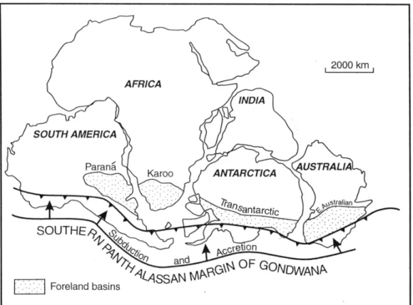
Figure 4: Regional outline of the Karoo basins in Southern Africa 8
Figure 5a: Late Palaeozoic
Gondwana framework and the
location of accretionary foreland basins (Turner, 1999) 9
Figure 5b: Geodynamic setting of the Main Karoo Basin as foreland basin to the Cape Fold-belt (Turner, 1999) 10
Figure 6: Geodynamic model explaining the origin of the northern Karoo basins 10
Figure 7: Major aeromagnetic interpretation lineaments associated with the Kalahari Karoo Basin structure 11
Figure 8: Boundaries to sub-basins of the Kalahari Karoo Basin relative to major pre-Karoo aeromagnetic interpretation structural elements 12 Figure 9: Lithostratigraphy and palaeoenvironments of the Karoo Supergroup 15
Figure 10: Sub-basins of the Kalahari Karoo Basin 16
Figure 11: Nomenclature and correlation of the Karoo Supergroup in Botswana 17
Materials and Methods
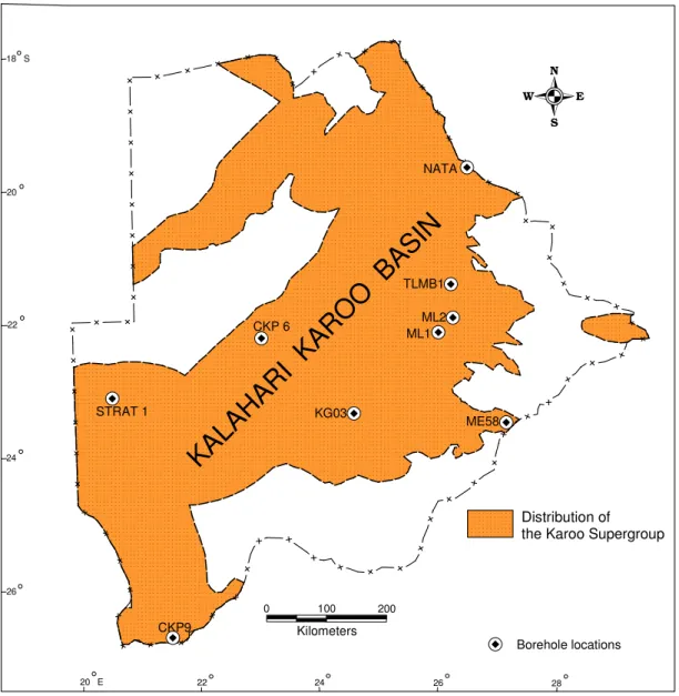
Figure 12: Locality map showing boreholes sampled for the study 23 Figure 13: STRAT 1 borehole section indicating sampled levels; sample numbers ending in -01 represent the initial 20 samples used for the trial run (A3 size) 24
Figure 14: CKP9 borehole section indicating sampled levels 25
Figure 15: CKP6 borehole section indicating sampled levels (A3 size) 26
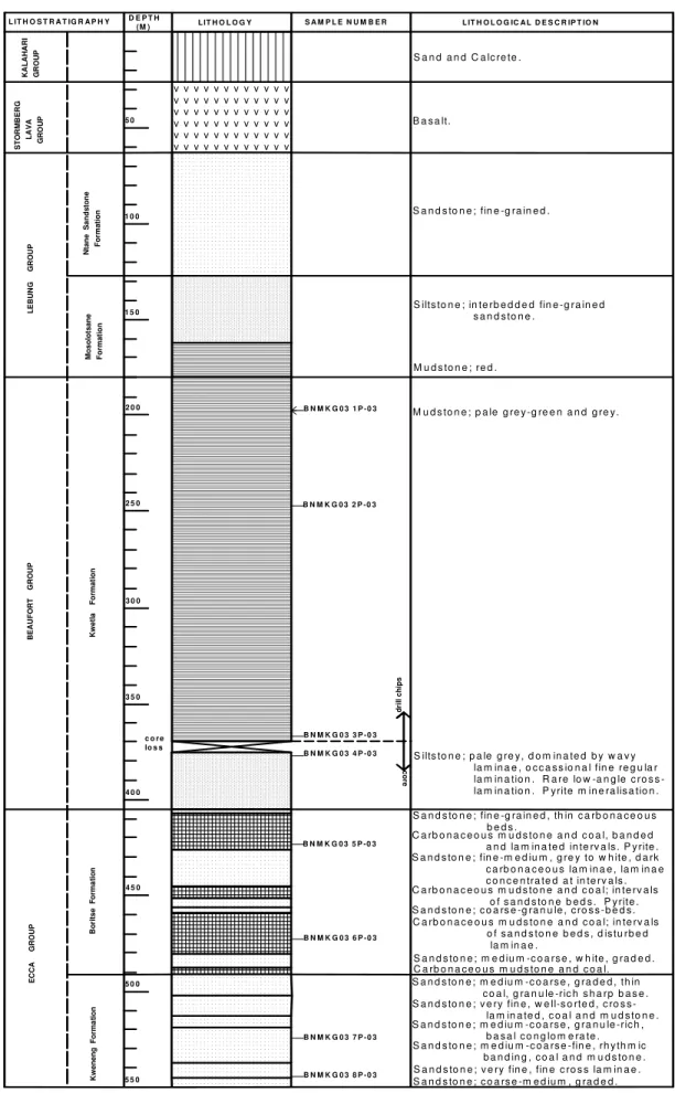
Contents xi Figure 16: KGO3 borehole section
indicating sampled levels 27
Figure 17: ML1 borehole section indicating sampled levels 28
Figure 18: ML2 borehole section indicating sampled levels 29
Figure 19: TLMB1 borehole section indicating sampled levels 30
Figure 20: NATA borehole section indicating sampled levels 31
Figure 21: ME58 borehole section indicating sampled levels 32
Systematic Palaeopalynology Figure 22: Principal morphological
features and measurement
terminology of trilete spores 38 Figure 23: Principal morphological
features and measurement
terminology of monolete spores 39 Figure 24: Principal morphological
features and measurement
terminology of monocolpate pollen 40
Figure 25: Principal morphological
features and measurement
terminology of monosaccate pollen 41.
Figure 26: Principal morphological
features and measurement
terminology of bisaccate pollen grains 42.
Results
Figure 27: Stratigraphic range chart
of determined taxa and
biostratigraphic subdivision of
STRAT 1 borehole section; broken lines reflect a zone of non-occurrence between the preceding relatively consistent occurrence and the last occurrence for the respective taxon (A3 size) 161
Figure 28: Stratigraphic range chart
of significant taxa and
biostratigraphic subdivision of
STRAT 1 borehole section 163 Figure 29: Summary of significant qualitative and quantitative analyses with subdivision of STRAT 1 borehole section (A3 size) 165 Figure 30: Significant assemblage zone taxa with subdivision of STRAT 1 borehole section 167 Figure 31: Summary of assemblage
zones highlighting notable
characteristics 169
Figure 32: Stratigraphic range chart
of determined taxa and
biostratigraphic subdivision of CKP 6 borehole section; broken lines reflect a zone of non-occurrence between the preceding or succeeding relatively consistent occurrence and
the last or first occurrence,
respectively (A3 size) 171
Figure 33: Stratigraphic range chart
of significant taxa and
biostratigraphic subdivision of CKP 6 borehole section 172
Figure 34: Summary of significant qualitative analyses with subdivision of CKP 6 borehole section (A3 size) 174
Figure 35: Significant assemblage zone taxa with subdivision of CKP 6 borehole section 176
Figure 36: Relative abundance and stratigraphic distribution of 3 major groups of sediment organic matter, and significant horizons (plotted as % of TSOM) 179
Figure 37: Relative abundance of 11 selected palynomorph groups
depicting their stratigraphic
distribution and significant horizons (plotted as % of TPa counted, including degraded palynomorphs not shown in figure) 181
Contents xii Figure 38: Relative abundance and
stratigraphic distribution of 4
selected phytoclasts categories, and significant horizons (plotted as % of TPh) 184
Figure 39: Stratigraphic distribution
of selected log10 ratios, and
significant horizons 186
Figure 40: Cluster analysis
dendrogram for total sediment
organic matter counts i.e. AOM (Amorphous organic matter), TPH (Total phytoclasts), and TPA (Total palynomorphs) 189
Figure 41: Cluster analysis
dendrogram for spores, pollen, and microplanktons depicting several associations of samples 190
Figure 42: Cluster analysis
dendrogram for selected categories
of phytoclasts e.g. Black
equidimensional (BLKE), Brown
equidimensional (BRNE), and
Cuticle and membranous tissues (CAMT) 191
Figure 43: Cluster analysis
dendrogram for total sediment
organic matter using only samples from the Malogong and Khuis formations, Dwyka Group 192
Figure 44: Cluster analysis
dendrogram for total sediment
organic matter using only samples from the Middlepits formation, Dwyka Group 193
Figure 45: Cluster analysis
dendrogram for total sediment
organic matter using only samples from the Kobe formation, Ecca Group 194
Figure 46: Cluster analysis
dendrogram for total sediment
organic matter using only samples from the Otshe formation, Ecca Group 195
Discussions
Figure 47: Biostratigraphic
correlation of STRAT 1 and CKP 6 boreholes 198
Figure 48: Tentative biostratigraphic correlation of STRAT 1 with CKP 9 200
Figure 49: Biostratigraphic
correlation chart of STRAT 1 borehole with other local previous studies 205
Figure 50: Biostratigraphic
correlation chart of STRAT 1 borehole with selected regional and Gondwana-wide zonation schemes.
Chronostratigraphic units are
sourced from the International
Stratigraphic Chart based on
Gradstein et. al. (2004) (A3 size) 216
Palaeoenvironmental Interpretations
Figure 51: Ternary AOM-total phytoclasts-total palynomorphs plot: (a) ternary plot based on dendrogram of Figure 40, (b) palynofacies fields and environments (see Table 2 for explanations) 227
Figure 52: Ternary microplankton-spore-pollen palynomorph plot: (a) ternary plot based on dendrogram of Figure 41, (b) ternary diagram for
palynomorphs indicating the
characteristic depositional
environments 230
Figure 53: Ternary black
equidimensional (BLKE)-brown
equidimensional (BRNE)-cuticular
and membranous tissues (CAMT)
phytoclasts plot, based on
Contents xiii
Figure 54: Small-scale
palaeoenvironmental stratigraphic
cycles in the Malogong and Khuis formations: (a) ternary AOM-TPH-TPA plot based on dendrogram of Figure 43, (b) proximal-distal trends, and notable relative abundances for the AOM 234
Figure 55: Small-scale
palaeoenvironmental stratigraphic
cycles in the Middlepits Formation: (a) ternary AOM-TPH-TPA plot based on dendrogram of Figure 44,
(b) proximal-distal trends, and
notable relative abundances for total
phytoclasts (TPh) and total
palynomorphs (TPa) 236
Figure 56: Small-scale
palaeoenvironmental stratigraphic
cycles in the Kobe Formation: (a) ternary AOM-TPH-TPA plot based on dendrogram of Figure 45, (b) proximal-distal trends, and notable
relative abundances for total
sediment organic matter 238
Figure 57: Small-scale
palaeoenvironmental stratigraphic
cycles in the Otshe Formation: (a) ternary AOM-TPH-TPA plot based on dendrogram of Figure 46, (b) proximal-distal trends, and notable
relative abundances for total
sediment organic matter 240 APPENDICES 288
Appendix I 288
1. All taxa index list Appendix II 293
1. STRAT1 all taxa occurrence
chart (A3 size) 293
2. STRAT 1 all taxa ranges with
biohorizons (A3 size) 294
3. CKP6 all taxa occurrence
chart (A3 size) 295
4. CKP6 all taxa range with
biohorizons (A3 size) 296
5. CKP9 borehole all taxa
occurrence chart 297
6. CKP9 borehole all taxa range
with biohorizons 298
7. KGO3 borehole all taxa
occurrence chart 299
8. ML1 borehole all taxa
occurrence chart 299
9. NATA borehole all taxa
occurrence chart 300
10. ME58 borehole all taxa
occurrence chart 300 Appendix III 301
1. Summary of palynofacies
horizons and their correlation with biohorizons, and notable characteristics of the
qualitative and quantitative analyses (A3 size) 301
Chapter 1: Introduction 1
KA
LA
HA
RI
K
AR
OO
B
AS
IN
CHAPTER 1: INTRODUCTION 1.1 Background to the StudyIn Botswana, late Palaeozoic to early Mesozoic sedimentary rocks and volcanic sequence belonging to the Karoo Supergroup occur in an extensive, centrally located area collectively termed the Kalahari Karoo Basin (Fig. 1).
Figure 1 Regional disposition of the Kalahari Karoo Basin in Botswana (Farr, 1981; Smith, 1984).
The Karoo Supergroup rocks host important natural resources dominated by coal, including coalbed methane natural gas, in addition to clay and groundwater resources. It is without doubt then that the Kalahari Karoo Basin holds great potential as a major contributor to build an economy of scale in Botswana, a country whose economic backbone is already anchored on mineral resources. Since it’s inception in 1948, the Botswana Department of Geological Survey (DGS), whose mission is to advance knowledge on earth resources, and to advice government and the public on their sustainable utilization, has pioneered several earth resources investigations in the Kalahari Karoo Basin (e.g. Green, 1966; Baldock et. al., 1977; Farr, 1981; Clark et. al., 1986; Gwosdz and Sekwale, 1982; Williamson, 1996; ECL, 1998; ARI, 2003). To date, huge amounts of coal resources, estimated at about 17 billion tons (SADC, 2001), have been discovered in Botswana. The discovery of coal in the Kalahari Karoo Basin provided Botswana with one of the major primary sources of energy
Chapter 1: Introduction 2 known in the world, which has over decades been the only known fossil fuel resource to exist in the country. Despite the great potential that coal has as a primary source of energy for homes and industry, and more significantly for the generation of electricity, it’s usage in Botswana still remains minimal. Stephenson and Penn (2005) also highlighted important benefits such natural resources, as is coal, could generate by creating wealth for poor communities through increased investment, direct employment and service provision.
On this realization, and in an attempt to further upgrade geological knowledge on the Kalahari Karoo Basin, the DGS initiated an applied science project, under the auspices of the National Development Plan 8 (NDP8) policy, with two main objectives:
1. To assess the availability and the potential to develop natural gas resources (i.e.
coalbed methane) associated with the coal-bearing sequences of the Kalahari Karoo Basin in Botswana.
2. To establish a database on stratigraphy and develop a correlation system that characterizes the coal-bearing sedimentary sequence of the Kalahari Karoo Basin in Botswana.
The works for the first objective of the project, successfully completed in 2003, were awarded to a private consultancy, namely, Advanced Resources International Inc. (USA), in association with Scales Associates (Botswana). The results of this study indicated that the coal beds within the study area contain an estimated gas-in-place resource of 60 trillion cubic feet (Tcf). The associated carbonaceous shales are estimated to contain an additional 136 Tcf, resulting in a combined total of 196 Tcf of gas-in-place (ARI, 2003).
The works for the second objective of the project, which forms the subject of this thesis, were incorporated into a collaborative research study with the school of doctorate of the University of Brest, in France.
1.2 Scope of Study
Although several projects initiated by the DGS have to date proven great potential in terms of economic resources associated with the Karoo sequence there is still a lack of adequate geological knowledge to effectively correlate across the entire Kalahari Karoo Basin. The situation is compounded by the lack of exposure owing to widespread cover by Cretaceous to recent sediments belonging to the Kalahari Desert environment, which has resulted in only an insignificant area of Karoo exposure (Figure 2). Nevertheless, several years of exploration, particularly coal exploration, has seen the continued use of the traditional method of stratigraphic correlation, based on lithological similarities, in the poorly exposed Kalahari Karoo Basin, to correlate widely spaced borehole sections (Farr, 1981; Smith, 1984; ECL, 1998). However,
Chapter 1: Introduction 3 correlations based solely on lithostratigraphic evidence have, through geological time, been found lacking in their chronostratigraphic significance and can lead to erroneous lithostratigraphic mis-correlations. This is because studies of sedimentary environments and facies distributions have shown that similar units can be deposited at different times, in different areas, and with no physical connection to each other (Reading, 1986; Mial, 1990). Lithostratigraphic correlations are reliable only in areas where beds can be physically traced out on the ground, and where there are distinctive and readily recognizable marker beds, a phenomenon that is rare in the Kalahari Karoo Basin.
Figure 2 Area of exposed Karoo Supergroup rocks in the Kalahari Karoo Basin (Farr, 1981; Smith, 1984; Modie, 2000).
The purpose of this study is to advance the concept of biostratigraphy in the Kalahari Karoo Basin of Botswana, and establish a preliminary biostratigraphic correlation scheme to augment the current lithostratigraphic correlation scheme that is being used. Biostratigraphy, which can be defined as the study of the relative arrangement of strata with regard to their fossil content (Miall, 1990; Murphy and Salvador, 1994) has become an indispensable aspect in lithostratigraphic correlations. The method of biostratigraphic correlation is used to erect zones of local or regional stratigraphic
24 18 S 20 22 24 26 20 E 22 Fault
KA
LA
HA
RI
K
AR
OO
BA
SIN
KALAHARI KAROO BASIN OF BOTSWANA
Karoo Supergroup 26 28 Exposures Zoetfontein FaultChapter 1: Introduction 4 correlations, and forms the basis for a global system of chronostratigraphic subdivision (Miall, 1990; Agterberg and Gradstein, 1999). Biostratigraphic zonation will help improve correlation of sections of the Karoo Supergroup from across the basin and minimize the use of local names for the same units in different parts of the basin, as is the case at present (e.g. Smith, 1984), which often give rise to difficulties in correlation during geological and mineral investigations. Additionaly, a biostratigraphic approach shall generate data that can be used to place the Kalahari Karoo Basin in both a regional and global setting.
In this study biostratigraphic horizons, which can be defined as stratigraphic boundaries, surfaces or interfaces across which significant biostratigraphic changes are noticed (Murphy and Salvador, 1994), are used as the basis for creating biozones. One better-preserved and closely sampled borehole section is designated a standard reference section. The standard reference section is then compared and correlated with other sections to produce a composite standard reference section. The composite standard reference section, which can be updated from time to time, as and when new data is availed, form the bases for a biostratigraphic correlation scheme in the Kalahari Karoo Basin.
1.3 Bases of Study
Palaeopalynology, which entails the study of palynomorphs i.e. plant microfossils and other remains of living organisms (Traverse, 1988; Jansonius and McGregor, 1996), is the main line of evidence used for biostratigraphic considerations in this study, owing to the unavailability of exposed sections for the study of larger scale fossils or macrofossils. Consequently, this study is specifically based on a palynostratigraphic approach, dominated by pollen and spore palynomorphs. The fundamental base upon which pollen and spore palynomorphs are utilized in correlation emanate from the fact that plants have evolved through geological time, during which various forms of palynormophs were deposited with sediments. As a result, palynomorph assemblages retrieved from different levels of the sedimentary strata are likely to be different in compositions, and hence, allow sequences to be differentiated.
Stratigraphic correlation studies in the Kalahari Karoo Basin are largely based on boreholes section, which has great potential for the retrieval of palynomorphs in contrast to that of macrofossils. Because of their small sizes (e.g. 200µm), palynomorphs are not affected by the smaller area coverage controlled by the drill-core diameters, which adversely affects the macrofossils, often resulting in only fragmentary evidence that is less reliable for biostratigraphic correlations. The fundamental advantage of palynomorphs lies in their highly protective and resistive external wall made of durable substances i.e. sporopollenin and chitin (Traverse, 1988). Sporopollenin on the outside wall allows pollen and spores to withstand and survive various depositional and burial processes of the rock sequence, as well as the rigorous laboratory maceration processes for their liberation for study. Relatively
Chapter 1: Introduction 5 good palynomorph preservations from borehole samples of the Kalahari Karoo Basin have been reported from some previous studies (e.g. Cadman, 1995).
In addition to palynomorph based evidence for biostratigraphic considerations, a major component of this study entails a general assessment of the sedimentary organic matter (SOM) present in the samples and their potential for correlation as well as palaeoenvironmental interpretations. SOM comprises the organic components of sedimentary rocks, inclusive of palynomorphs, and often largely dominated by the remains of land plants such as tree trunks, branches, and leaves (Batten, 1996). The SOM found in sedimentary rocks has undergone various pre- and post-depositional physical and chemical changes but the remains consist of various recognizable categories. Because sedimentary organic matter forms an integral part of the sedimentary rock the constituent categories are considered useful in the interpretation of depositional environments (Batten, 1996). Different palynomorph types can give insight into ancient environments in which parent organisms lived, as well as palaeoclimatic environments at source of sediments (Traverse, 1988). Studies in which acid-resistant organic matter have been categorized to define what are termed palynofacies (Combaz, 1964) are very common in palynological investigations, an approach which is generally similar to the interpretation of sedimentary facies in sedimentology (e.g. Courtinat, B., Piriou, S. and Rio, M, 2003; Roncalgia, L, 2004; Martin-Closas, C., Permanyer, A. and Vila, M, 2005; Masselter, T. and Hofmann, C, 2005).
1.4 Previous Work
There is a limited amount of previous palynological investigations undertaken from the Kalahari Karoo Basin of Botswana. The level and density of palynological information occurrence is still very low and of a sporadic nature across the basin. No palynofacies studies have ever been undertaken.
MacRae (1978) created the first preliminary biozonation system for the Karoo Supergroup in Botswana, which was based on samples from one borehole (N1/3) along the northeastern fringe of the basin. This work established the occurrence of three concurrent range zones (I, II, III) based on the species ranges and quantitative distribution of the major miospore taxa in the palynomorph assemblages. The positions of the lower and upper limits of the concurrent range zones I and III, respectively, were not conclusive from this study.
In a combined palaeontological and radiometric studies to determine the onset of Karoo vulcanicity Aldiss et. al (1984) established the occurrence of Early Jurassic palynomorphs i.e. Classopollis intrareticulatus. The palynomorphs were found in fluvio-lacustrine sedimentary rocks of the Tuli Sub-basin, intercalated with lava at the base of Karoo basalt, marking the end of Karoo sedimentation and the upper limit of the Lebung Group.
Chapter 1: Introduction 6
Dolby (1990) established the occurrence of two zones based on
micropalaeontological and palynological assemblages obtained from a lower Karoo Supergroup section (i.e. lower Ecca to Dwyka) intersected in a petroleum investigation borehole (Masetlheng Pan-1) drilled in southwest Botswana. The two zones, from young to old, were assigned to an Early Permian (Sakmarian-Asselian) and Late Carboniferous (Gzhelian-Kasimovian) age, respectively.
ECL (1990) developed a regional palynozonation scheme (MZI – MZV) in an attempt to underline the importance of chronostratigraphic control within the Lower Karoo sequence of southern Africa as opposed to the commonly used stratrigraphic subdivision based solely on lithostratigraphic features across the region. The scheme was based on palynological analyses of borehole and field samples from Namibia, Botswana, Zimbabwe and Zambia, in addition to published literature on Karoo palynology. Much of the samples analysed from the Kalahari Karoo Basin were from the Dwyka and Ecca section of the lithostratigraphy, and the recovered palynomorphs indicate Permian age.
Drilling for water in a Tribal Grazing Land Policy programme in southwest Botswana (northern Gemsbok Sub-basin) provided several lower Karoo Supergroup samples for Cadman (1995) to establish six palynological biozones (A – F), based on fossil pollen-spore assemblages. The six biozones range from Late Permian (Tatarian – Kazanian) to Late Carboniferous (Gzhelian – Kasimovian) ages.
Key et. al. (1995) presents biozone and age divisions of a lower Karoo Supergroup section from southwest Botswana, in the southern Gemsbok Sub-basin of the Kalahari Karoo Basin. This work however does not include the data (palynomorph assemblages) from which the biozones and ages were derived from.
The latest palynological publication from the Kalahari Karoo Basin is the work of Stephenson and McLean (1999) that gives details of palynological assemblages from the Morupule Main Seam, the main coal seam currently mined at Morupule Colliery, along the eastern fringe of the Kalahari Karoo Basin. Extensive regional and Gondwana-wide correlations based on palynological assemblages are detailed in this work. Strata of the Karoo Supergroup that host the Morupule Main Seam is assigned to an Early Permian age.
Figure 3 is a summary of the previous palynological studies undertaken on rocks of the Karoo Supergroup in Botswana.
Chapter 1: Introduction 7 C A R B O N IF E R O U S U P P E R G z h e li a n -K a s im o v ia n P E R M IA N U P P E R A r ti n s k ia n K a z a n ia n L O W E R JU R A S S IC L O W E R S a k m a ri a n -A s s e li a n DWYKA GROUP STRATIGRAPHY
AGE STAGE LOCATION
STORMBERG LAVA GROUP T o a r c ia n -S in e m u r ia n ECCA GROUP
Aldiss, Benson & Rundle, 1984 TULI BASIN
Intercalated fluvio-lacustrine sediments at base of volcanics
Northern Belt Central Kalahari Sub-basin
West Central Kalahari Sub-basin
South West Botswana North East Botswana Northern Belt & South East Central Kalahari Sub-basin. West Central Kalahari Sub-basin
AUTHOR
ECL, 1990
MacRae, 1978 ECL, 1990 South West Botswana
Dolby, 1990 ECL, 1990
Key, McGeorge, Aitken, Cadman, Tidi & Anscombe, 1995
MacRae, 1978 ECL, 1990
Stephenson & McLean, 1999 ECL, 1990
Dolby, 1990 ECL, 1990 Cadman, 1995
Key, McGeorge, Aitken, Cadman, Tidi & Anscombe, 1995
Figure 3 Summary of previous palynology studies in Botswana.
Chapter 2: Background Geology 8 CHAPTER 2: BACKGROUND GEOLOGY
2.1 Regional Setting
The Kalahari Karoo Basin of Botswana is one among several contemporaneous Karoo basins (Smith et. al., 1993; Johnson et. al., 1996; ECL, 1998) of southwestern Gondwana that became active in the Permo-Carboniferous times (Fig. 4).
Figure 4: Regional outline of the Karoo basins in Southern Africa (ECL, 1998).
Sedimentation in these basins continued to accumulate until it was interrupted and eventually brought to a close by widespread flood basaltic volcanism, initiated by extensional tectonics in the early Jurassic, which marked the onset of Gondwana break-up (Cox, 1992; ECL, 1998; Jourdan et. al., 2005). The maximum pre-erosion areal extent of the Karoo basins of southern Africa, in early Permian times, is
considered to have covered about 4.5 million km2,with a thickness range of 10 000m
to 1000m, recorded in the Main Karoo and Cabora Bassa basins, and the other subsidiary basins, respectively (Smith et. al., 1993; Johnson et. al., 1996). Several dolerite dikes, that are considered to represent conduits for Karoo basalts, are
Chapter 2: Background Geology 9 abundant across the region. The sedimentary fill of the Karoo basins throughout southern Africa have a remarkably uniform lithologic characteristics and fossil assemblages, which has been a great aid in regional stratigraphic correlation. In addition, the Karoo basins of southern Africa host all the coal deposits in the region. The largest of the Karoo basins, which is also the type basin for Karoo stratigraphy, is the Main Karoo Basin of South Africa that is considered to have developed as a foreland basin to the Cape Foldbelt (Johnson, 1991; Smith et. al., 1993; Johnson et. al., 1996; Turner, 1999). The Kalahari Karoo Basin of Botswana and several other subsidiary basins in South Africa, Namibia, Botswana, Zimbabwe and Mozambique are classified as intracratonic sag basins or rift basins (Orpen et. al., 1989; Verniers et. al., 1989; Johnson et. al., 1996; ECL, 1998; Holzforster et. al., 1999).
The exact geodynamic setting for the Kalahari Karoo basin, together with the other Karoo basins remains little understood. However, several workers e.g. Daly et al. (1991), Cox (1992), ECL (1998), and Turner (1999) have attributed origin of these basins to collision induced extensional tectonics related to the Late Palaeozoic to Early Mesozoic Gondwanide Cape orogeny that resulted from the subduction of a palaeo-Pacific plate under southern Gondwana. The latter gave rise to the development of the main Karoo Basin in the south as a retro-arc foreland basin to the Cape Foldbelt (Fig. 5a, b), while the Kalahari Karoo Basin, and other subsidiary basins, developed in the north as intracratonic basins.
Figure 5a: Late Palaeozoic Gondwana framework and the location of accretionary foreland basins (Turner, 1999).
Chapter 2: Background Geology 10
Figure 5b: Geodynamic setting of the Main Karoo Basin as foreland basin to the Cape Fold-belt (Turner, 1999).
Through the mechanism of collision-induced tectonics ECL (1998) invoked an interpretive model that depicts compressional re-activation and pull-apart basin development, with a continental “escape” vector, as the main
setting for the
northern basins
(Fig. 6).
Figure 6: Geodynamic model explaining the origin of the northern Karoo basins (ECL, 1998).
Chapter 2: Background Geology 11 2.2 Structural Development
The sub-surface structural framework of the Kalahari Karoo basin is little understood due to widespread cover by sediments of the Kalahari Desert environment. Consequently much of the covered centrally located Kalahari Karoo basin has hitherto been considered to define an intracratonic sag basin. Only along the eastern fringe of the basin, where there is limited exposure and near-surface bedrock, has it been possible to demonstrate the occurrence of fault-bounded graben structures (Green et. al., 1980; Williamson, 1996). In recent times though, the use of potential field data (e.g. seismic, aeromagnetics) to delineate major structural elements, such as faults and lineaments, indicates a rift basin setting for parts of the covered interior of the Kalahari Karoo basin (Davison and Steenkamp, 1995).
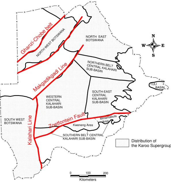
The structural evolution of the Kalahari Karoo basin appears to have been influenced by pre-Karoo (Archaean, Proterozoic) structural elements as evidenced by the close association of major interpreted geophysical lineaments (Fig. 7) and the basin disposition
(ECL, 1998).
Such lineaments (Carney et. al.,
1994), which includes the Kalahari Line, the Makgadikgadi Line, the Zoetfontein Fault, and fault lines associated with the Pan African Ghanzi-Chobe belt, generally parallels major boundaries that defines segments of the Kalahari Karoo Basin (Fig. 8).
Figure 7: Major aeromagnetic interpretation lineaments associated with the Kalahari Karoo Basin structural setting (source: DGS).
Chapter 2: Background Geology 12
Distribution of
the Karoo Supergroup
22 24 20 E WESTERN CENTRAL KALAHARI SUB-BASIN SOUTH WEST BOTSWANA NORT H WES T BOT SWAN A
Kweneng Area NORTH EAST BOTSWANA NORTHERN BELT CENTRAL KALAHARI SUB-BASINSOUTHERN BELT CENTRAL KALAHARI SUB-BASIN Mmamabula Area SOUTH-EAST CENTRAL KALAHARI SUB-BASIN TULI BASIN Zoetfonte in Fault Makg adikg adi L ine K al ah ar i L in e Ghan zi-Ch obe b elt 0 100 Kilometers 200
Figure 8: Boundaries to sub-basins of the Kalahari Karoo Basin relative to major pre-Karoo aeromagnetic interpretation structural elements.
Chapter 2: Background Geology 13 The exact nature of the relationship between the Kalahari and Makgadikgadi lines with the Karoo basin configuration is not unequivocal. ECL (1998) considers the Kalahari and Makgadikgadi lineaments to represent the edge of more stable cratonic blocks. In the Ghanzi-Chobe belt Karoo rocks are preserved in fault-bounded graben structures that are clearly superimposed on older lineaments of the Pan African Damara Orogeny (Modie, 1996). On the other hand, the Zoetfontein Fault, which appears to be a reactivation of older tectonic features between the Archaean Kaapvaal Craton and the Limpopo Belt, can be geophysically traced westward into the interior of the Kalahari Karoo basin (Williamson, 1996; ECL, 1998). A seismic survey interpretation of the Karoo Supergroup reflects reactivation of the Zoetfontein Fault during Karoo sedimentation and its development as a growth fault (Davison and Steenkamp, 1995). The present structural elements (i.e. open folds, normal faulting, inversion etc.) of the Kalahari Karoo basin, as interpreted from seismic data, represent several phases of Mid-Late Karoo and post-Karoo compressional or extensional tectonics (ECL, 1998).
2.3 Stratigraphy
Sub-division of Karoo stratigraphy in the Kalahari Karoo basin is largely based on lithological distinctions than it is on palaeontological aspects because of the unavailability of exposure to study fossils. The earlier “Karroo System” for Bechuanaland by Green (1966) although implying a chronostratigraphic sequence was essentially based on lithological factors and relied heavily on regional correlation with the “Karroo System” of South Africa (e.g. Du Toit, 1954). Subsequently, the Karoo of Botswana has been described under the lithostratigraphic term “Supergroup” by Stansfield (1973) working in the north of the country i.e. in the Dukwi (2026C) and Tlalamabele (2126A) areas. Several other workers in the country have since adopted this usage e.g. Aldiss (1983a/b), Meixner and Peart (1984), Smith (1984), Williamson (1996) etc. The Karoo Supergroup is divided into group and formation ranks most of which have lithological equivalents in the Main Karoo Basin of South Africa, as well as in Namibia and Zimbabwe.
The group nomenclature is largely adopted from the South African stratigraphy, owing to correlation with the better-exposed Main Karoo basin, and comprises such terminology as the Dwyka, Ecca, and Beaufort groups (SACS, 1980; Carney et. al., 1994; Johnson et. al., 1996). Figure 9 shows a generalized lithostratigraphy of the Karoo Supergroup from across the Kalahari Karoo Basin in Botswana. Overall, the broad lithostratigraphy of the Kalahari Karoo basin can be generally sub-divided into Lower and Upper Karoo about a major regional mid-Karoo unconformity (ECL, 1998). Sequences assigned to the Lower Karoo include the Dwyka, Ecca, and Beaufort groups whilst those assigned to the Upper Karoo include the Lebung and Stormberg Lava groups (Fig. 9).
Younger Cretaceous to Recent sediments masks much of the area underlain by the Karoo rocks, except for pockets of exposures (Fig. 2) confined to the basin fringe (Modie, 2000), as a result knowledge on the Karoo stratigraphy in Botswana has relied extensively on borehole information obtained from coal exploration. However, several of
Chapter 2: Background Geology 14 the coal exploration companies have tended to use different local formation names for the same units, which pose difficulties during correlation. There is yet no formalised stratigraphy of the Karoo Supergroup in Botswana. Smith (1984) divided the Kalahari Karoo basin into seven depositional sectors or sub-basins (Fig. 10) on the basis of geological setting and facies changes, with some however delineated on the basis of convenience for description. Sequences established in the seven sub-basins were given local formation names and correlated across the country (Fig. 11). This lithostratigraphy (i.e. Smith, 1984) now forms the basis for geological correlation of the Karoo Supergroup in the Kalahari Karoo basin of Botswana.
Chapter 2: Background Geology 15
Figure 9: Lithostratigraphy and palaeoenvironments of the Karoo Supergroup, Kalahari Karoo Basin, Botswana. B E A U FO R T D W Y K A G R O U P AGE STRATIGRAPHY
La
te
C
ar
bo
ni
fe
ro
us
-
E
ar
ly
J
ur
as
si
c
E C C A G R O U P LE B U N G G R O U P S TO R M B E R G LA V A G R O U PK
A
R
O
O
S
U
P
E
R
G
R
O
U
P
Basalt > amygdaloidal181 Ma
Mudstone Mudstone, varvites, siltstone, sandstone, and tillites Red beds > sandstone > siltstone, mudstone> sandstone, rare c/glomerate Siltstone, mudstone, limestone
LITHOLOGY
Sandstone, siltstone,
carbonaceous mudstone, and coal
>Aeolian >Fluvial >Lacustrine
Transitional >Lacustrine
De-glaciation, and amelioration of the palaeo-climate. >Fluvio-deltaic >Swamps >Lacustrine/marginal marine Glacial palaeo-climate >Subglacial >Glacio-fluvial >Glacio-lacustrine
Continental flood basalts DEPOSITIONAL ENVIRONMENT
>extensional tectonics related to on-set of Gondwana break-up.
Chapter 2: Background Geology 16
Distribution of the Karoo Supergroup
18 S 20 22 24 26 22 24 20 E WESTERN CENTRAL KALAHARI SUB-BASIN SOUTH WEST BOTSWANA NORT H W EST B OTSW ANA Kweneng Area NORTH EAST BOTSWANA NORTHERN BELT
CENTRAL KALAHARI
SUB-BASIN
SOUTHERN BELT CENTRAL KALAHARI SUB-BASIN Mmamabula Area 26 SOUTH-EAST CENTRAL KALAHARI SUB-BASIN 28 TULI BASIN SUB-BASINS OF THE KALAHARI KAROO BASIN (Smith, 1984)
Chapter 2: Background Geology 17 DWYKA
(Dwyka Series)
GROUPS
STOMBERG LAVA (U. Stomberg Series)
SOUTH WEST KWENENG/WESTERNCENTRAL KALAHARI MMAMABULA
? ECCA (Ecca Series) LEBUNG (L. Stormberg Series) (Beaufort Series) Otshe Fm. Kule Fm. Nakalatlou Sst. Dongdong Fm. Bori Fm. Bori Fm. Kobe Fm. Middlepits Fm. Khuis Fm. Malogong Fm. Mmamabula Fm. Mosolotsane Formation Kwetla Fm. Boritse Fm. Kweneng Fm. Korotlo Fm. Mosomane Fm. Dukwi Formation Kamotaka Fm. Morupule Fm. Serowe Fm.
Ntane Sandstone Formation Tlhabala Formation Ngwasha (n/east) Pandamatenga Makoro Fm. ? Mofdiahogolo Fm. Tlapana Fm. Mea Arkose Tswane Fm. ? S.E. CENTRAL
KALAHARI NORTH EAST AND NORTHERN BELT
Bobonong Lava Fm. Savuti Fm. NORTH WEST Bodibeng Sst. Marakwena Fm. Tale Fm. ? Seswe Formation ? TULI BASIN Tsheung Sst. Thune Fm. Korebo Fm.